Rural Alabama. Jennifer Zanoni. Geography Division U.S. Census Bureau. Alabama State Data Center 2018 Data Conference Tuscaloosa, Alabama
|
|
|
- Daniella Parker
- 5 years ago
- Views:
Transcription
1 Rural Alabama Jennifer Zanoni Geography Division U.S. Census Bureau Alabama State Data Center 2018 Data Conference Tuscaloosa, Alabama May 17, 2018
2 Agenda Census Geography Urban/Rural Definitions County-based Demographics 2020 Census Questions 2
3 3
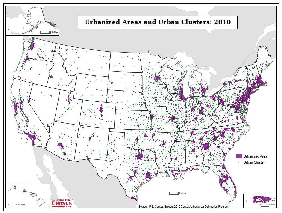
4 Urban Population as a Percentage of Total US Population, Percent Urban : urbanized areas of 50,000+ adopted. 2000: urban clusters of 2,500-49,999 adopted. 4
5 Census Bureau designated Urban Areas Delineated decennially Two types of urban areas: Urbanized Areas (UAs) of 50,000 or more people Urban Clusters (UCs) of at least 2,500 and less than 50,000 people 5
6 Urban and Rural Population in the United States: 2010 and Population 2000 Percent 2010 Population 2010 Percent Urban 222,360, ,253, Urbanized Area 192,323, ,922, Urban Cluster 30,036, ,331, Rural 59,061, ,492,
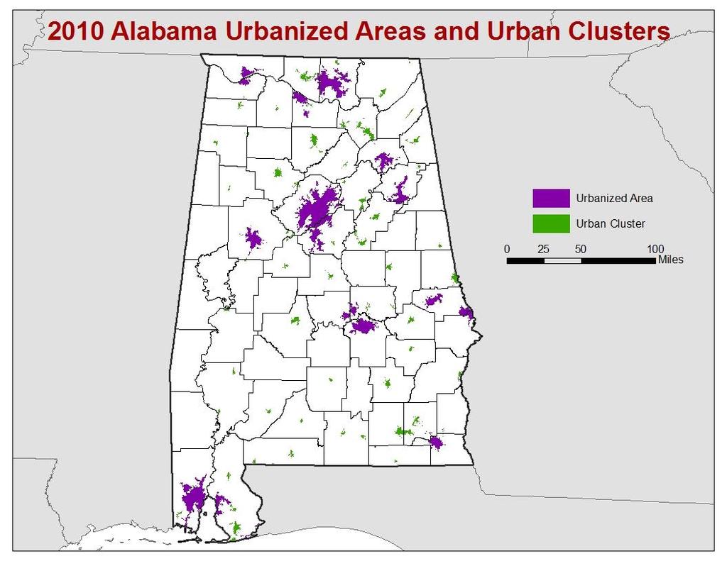
7 Urban/Rural Population: Alabama 6,000,000 Percent Rural 5,000,000 4,000,000 3,000, : 44.6% 2010: 41.0% ,000,000 1,000,000 0 Total Urban Rural 7
8
9 9
10 10
11 11
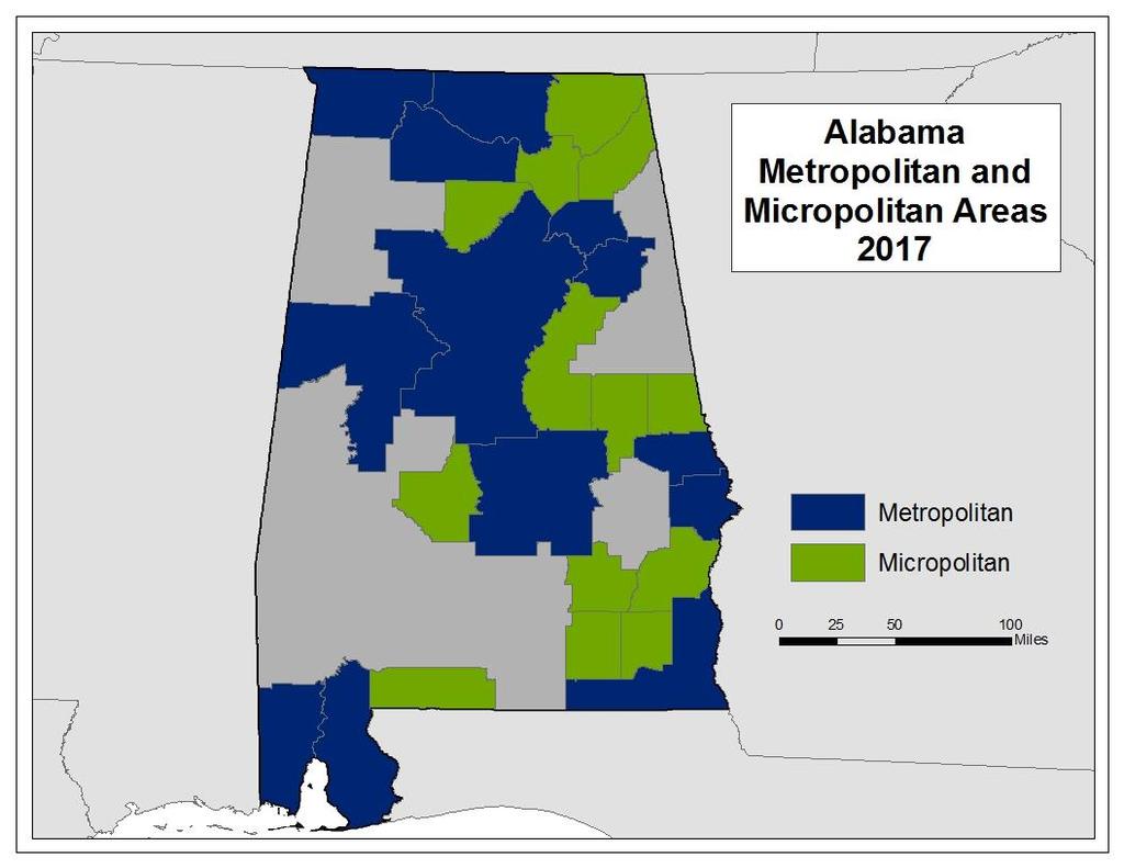
12 Metropolitan and Micropolitan Statistical Areas Defined by U.S. Office of Management and Budget (OMB) County Level Metropolitan Statistical Areas associated with at least one urbanized area with 50,000 population adjacent counties having a high degree of social and economic integration with the core as measured through commuting ties Micropolitan Statistical Areas associated with at least one urban cluster of at least 10,000 population adjacent counties having a high degree of social and economic integration with the core as measured through commuting ties 12
13 13
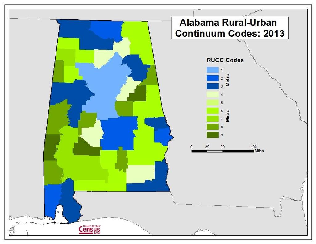
14 USDA Rural Classifications County Level Rural-Urban Continuum Codes Sub-County Level Frontier and Remote Areas Codes 14
15 Rural-Urban Continuum Codes 2013 (update planned for mid-2023) Based on OMB Metropolitan and Micropolitan categories Metropolitan counties by the population size of their metro area Nonmetropolitan counties by degree of urbanization and adjacency to a metro area Subdivided into three metro and six nonmetro categories Every county assigned one of the 9 codes 15
16 Micro Metro Code Rural-Urban Continuum Codes Description 1 Counties in metro areas of 1 million population or more 2 Counties in metro areas of 250,000 to 1 million population 3 Counties in metro areas of fewer than 250,000 population 4 Urban population of 20,000 or more, adjacent to a metro area 5 Urban population of 20,000 or more, not adjacent to a metro area 6 Urban population of 2,500 to 19,999, adjacent to a metro area 7 Urban population of 2,500 to 19,999, not adjacent to a metro area 8 Completely rural or less than 2,500 urban population, adjacent to a metro area 9 Completely rural or less than 2,500 urban population, not adjacent to a metro area 16
17 17
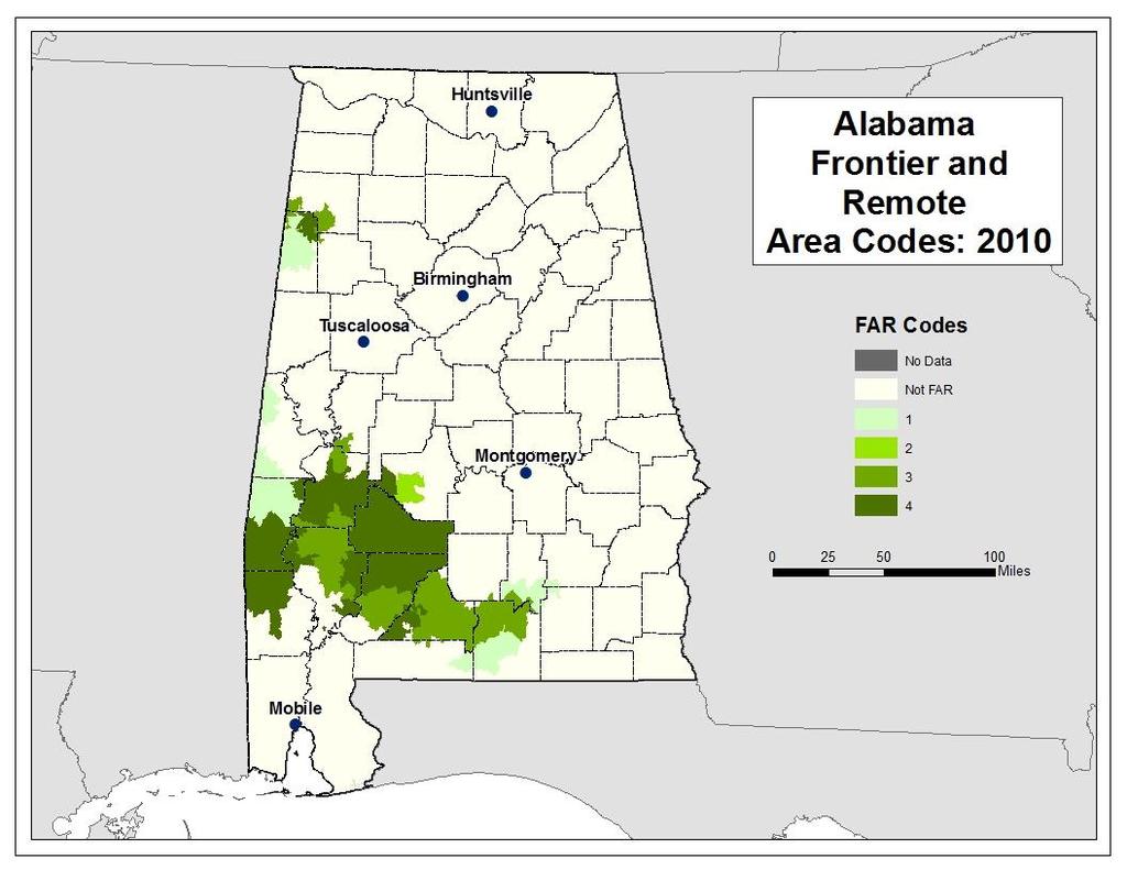
18 Frontier and Remote Area Codes ESRI zip code area level Based on different population thresholds Meant to reflect likely access to high order services (level one), low order services (level four), and intermediate order services (levels two and three) Level Description 1 Rural areas and urban areas up to 50,000 people that are 60 minutes or more from an urban area of 50,000 or more people 2 Rural areas and urban areas up to 25,000 people that are: 45 minutes or more from an urban area of 25,000-49,999 people; and 60 minutes or more from an urban area of 50,000 or more people 3 Rural areas and urban areas up to 10,000 people that are: 30 minutes or more from an urban area of 10,000-24,999; 45 minutes or more from an urban area of 25,000-49,999 people; and 60 minutes or more from an urban area of 50,000 or more people 4 Rural areas that are: 15 minutes or more from an urban area of 2,500-9,999 people; 30 minutes or more from an urban area of 10,000-24,999 people; 45 minutes or more from an urban area of 25,000-49,999 people; and 60 minutes or more from an urban area of 50,000 or more people 18
19 19
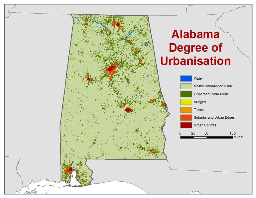
20 Cell level criteria Residents per sq km Refined Degree of Urbanisation Settlements by population size Areas outside settlements Small Medium Large 500 5,000 5,000 50,000 >50,000 High Density >1,500 Town Urban Centre Medium Density 300 1,500 Not Applicable Village Suburb & Urban Edge Low Density Rural Dispersed Areas Very Low Density <50 Mostly Uninhabited Areas
21 21
22 22
23 23
24 24
25 What is rural? What characterizes rurality? Low population density Small numbers of people Low levels of urbanization/urban population Distance from/proximity to [larger] urban centers Isolation and remoteness Rural often is defined as the residual. This could be not urban or not metropolitan in a dichotomous classification, or what remains after all other categories in a multi-category classification have been defined. 25
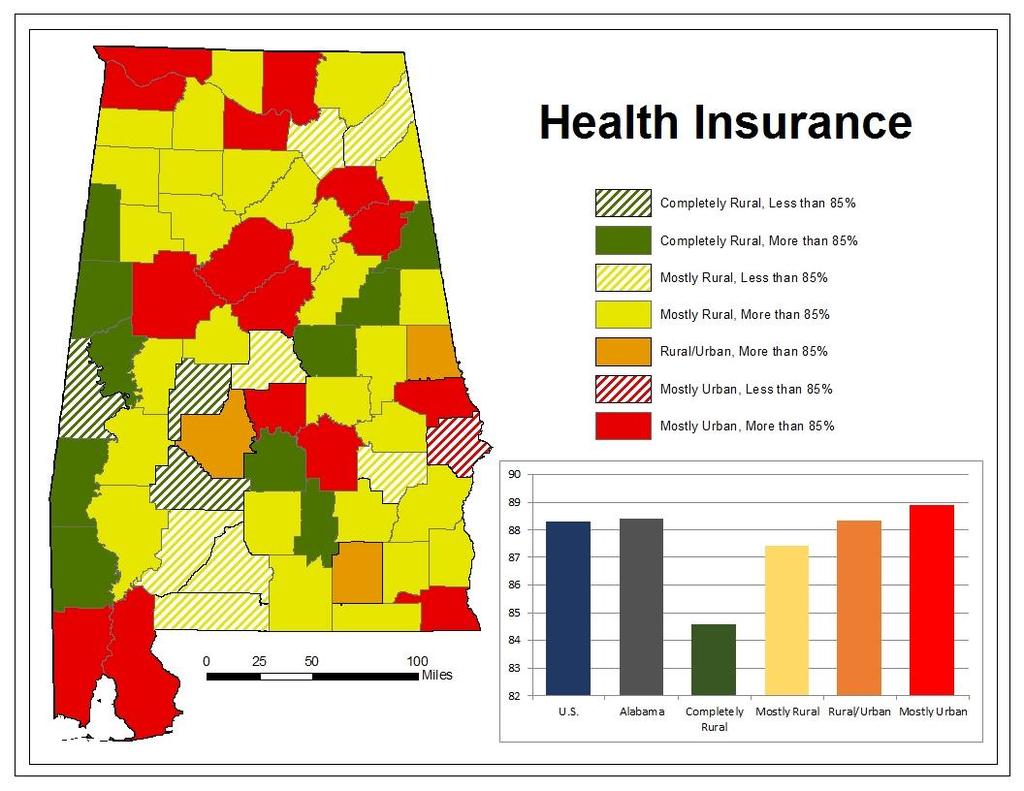
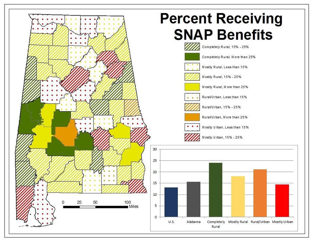
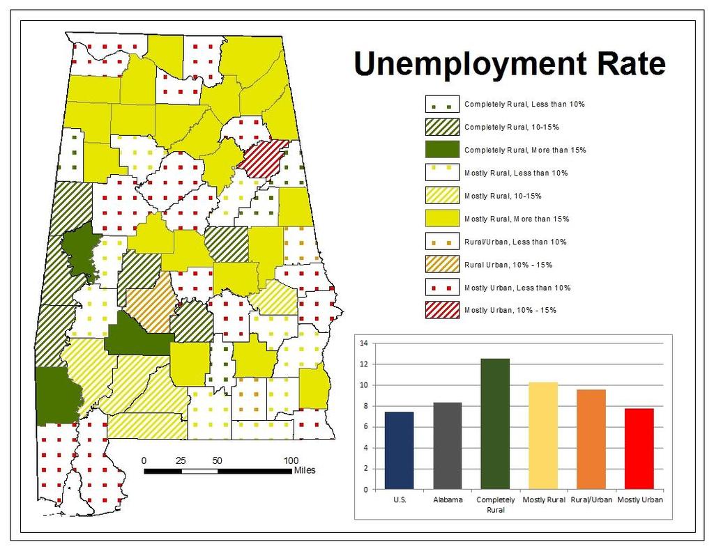
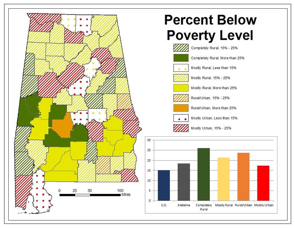
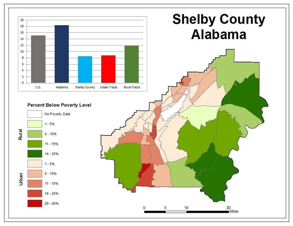
26 Rural Alabama Completely Rural: 100% of population lives in areas that have lower population density with <1,000 people per square mile (Clarke County) Mostly Rural: 50.1% to 99.9% of the population lives in areas with lower population density (Barbour County) Rural/Urban: Counties with populations < 50,000 people that have >50% of people in higher population density (Coffee County) Mostly Urban: Counties with Populations > 50,000 people that have >50% of people in higher population density (Shelby County) 26
27 27
28 28
29 29
30 30
31 31
32 32
33 33
34 34
35 35
36 36
37 37
38 2020 Urban Areas and Future 2020 Urban Areas Delineation Criteria How to define a Rural Statistical Area? 38
39 Questions? Comments? Contact information: Jennifer Zanoni
Rural Pennsylvania: Where Is It Anyway? A Compendium of the Definitions of Rural and Rationale for Their Use
 Rural Pennsylvania: Where Is It Anyway? A Compendium of the Definitions of Rural and Rationale for Their Use Pennsylvania Office of Rural Health 310 Nursing Sciences Building University Park, PA 16802
The History Behind Census Geography
 The History Behind Census Geography Michael Ratcliffe Geography Division US Census Bureau Tennessee State Data Center August 8, 2017 Today s Presentation A brief look at the history behind some of the
The History Behind Census Geography
 The History Behind Census Geography Michael Ratcliffe Geography Division US Census Bureau Kentucky State Data Center Affiliate Meeting August 5, 2016 Today s Presentation A brief look at the history behind
The Rural Health Workforce. Policy Brief Series. Data and Issues for Policymakers in: Washington Wyoming Alaska Montana Idaho
 The Health Workforce Data and Issues for Policymakers in: Washington Wyoming Alaska Montana Idaho Policy Brief Series ISSUE #1: THE RURAL HEALTH WORKFORCE: CHALLENGES AND OPPORTUNITIES ISSUE #2: THE RURAL
Frontier and Remote (FAR) Area Codes: A Preliminary View of Upcoming Changes John Cromartie Economic Research Service, USDA
 Area Codes: A Preliminary View of Upcoming Changes John Cromartie Economic Research Service, USDA") National Center for Frontier Communities webinar, January 27, 2015 Frontier and Remote (FAR) Area Codes: A Preliminary View of Upcoming Changes John Cromartie Economic Research Service, USDA The views
National Center for Frontier Communities webinar, January 27, 2015 Frontier and Remote (FAR) Area Codes: A Preliminary View of Upcoming Changes John Cromartie Economic Research Service, USDA The views
US Census Bureau Geographic Entities and Concepts. Geography Division
 US Census Bureau Geographic Entities and Concepts Geography Division Geographic Concepts Addresses vs. Geographic features and entities Legal/Administrative vs. Statistical Nesting relationships (or the
DRAFT RURAL-URBAN POPULATION CHANGE IN PUERTO RICO, 1990 TO 2000
 DRAFT RURAL-URBAN POPULATION CHANGE IN PUERTO RICO, 1990 TO 2000 Mei-Ling Freeman Geographic Standards and Criteria Branch Geography Division US Census Bureau For presentation at the Western Regional Science
Improving rural statistics. Defining rural territories and key indicators of rural development
 Improving rural statistics Defining rural territories and key indicators of rural development Improving rural statistics Improving Rural Statistics In 2016, the Global Strategy to improve Agricultural
Census Geography, Geographic Standards, and Geographic Information
 Census Geography, Geographic Standards, and Geographic Information Michael Ratcliffe Geography Division US Census Bureau New Mexico State Data Center Data Users Conference November 19, 2015 Today s Presentation
Passenger Transportation Networks & Urbanization Level: A Comparison of Classification Schemes
 Pyrialakou, Nlenanya, Gkritza 0 0 Passenger Transportation Networks & Urbanization Level: A Comparison of Classification Schemes V. Dimitra Pyrialakou (Corresponding author) Graduate Research Assistant,
International Workshop on Defining and Measuring Metropolitan Regions (Paris, France, 27 th November, 2006)
") OECD Special Session International Workshop on Defining and Measuring Metropolitan Regions (Paris, France, 27 th November, 2006) Defining an Measuring Metropolitan Areas: A Comparison between Canada and
OECD Special Session International Workshop on Defining and Measuring Metropolitan Regions (Paris, France, 27 th November, 2006) Defining an Measuring Metropolitan Areas: A Comparison between Canada and
Tracey Farrigan Research Geographer USDA-Economic Research Service
 Rural Poverty Symposium Federal Reserve Bank of Atlanta December 2-3, 2013 Tracey Farrigan Research Geographer USDA-Economic Research Service Justification Increasing demand for sub-county analysis Policy
Census Urban Area Comparisons, 2000 to 2010
 THE HONORABLE ROGERS Mayor ANDERSON, Karl Dean, CHAIRMAN Chairman Census Urban Area Comparisons, 2000 to 2010 TCC May 2, 2012 MPOs/RPOs in Tennessee Regional Geographies in Middle TN Nashville MPO Clarksville
DEFINING AND MEASURING RURALITY IN THE US: FROM TYPOLOGIES TO CONTINUOUS INDICES
 DEFINING AND MEASURING RURALITY IN THE US: FROM TYPOLOGIES TO CONTINUOUS INDICES Brigitte Waldorf and Ayoung Kim Department of Agricultural Economics, Purdue University West Lafayette, IN 47907, USA Email:
Secondary Towns, Population and Welfare in Mexico
 Public Disclosure Authorized Public Disclosure Authorized Public Disclosure Authorized Secondary Towns, Population and Welfare in Mexico Isidro Soloaga Department of Economics, Universidad Iberoamericana,
Operational Definitions of Urban, Rural and Urban Agglomeration for Monitoring Human Settlements
 Operational Definitions of Urban, Rural and Urban Agglomeration for Monitoring Human Settlements By Markandey Rai United Nations Human Settlements Programme PO Box-30030 Nairobi, Kenya Abstract The United
British Household Panel Survey, waves 1-17 ( )
") UK Data Archive Study Number 6032 - British Household Panel Survey, Waves 1-17, 1991-2008: Conditional Access, Rural-Urban s British Household Panel Survey, waves 1-17 (1991-2008) User Documentation: Rural-Urban
UK Data Archive Study Number 6032 - British Household Panel Survey, Waves 1-17, 1991-2008: Conditional Access, Rural-Urban s British Household Panel Survey, waves 1-17 (1991-2008) User Documentation: Rural-Urban
DIALOGUES on Research and Policy
 W E S T C O A S T P O V E R T Y C E N T E R Box 354900 Seattle, WA 98105 www.wcpc.washington.edu West Coast Poverty Center U N I V E R S I T Y O F W A S H I N G T O N A Partnership of the SCHOOL OF SOCIAL
Policy Paper Alabama Primary Care Service Areas
 Aim and Purpose Policy Paper Alabama Primary Care Service Areas Produced by the Office for Family Health Education & Research, UAB School of Medicine To create primary care rational service areas (PCSA)
Updating the Urban Boundary and Functional Classification of New Jersey Roadways using 2010 Census data
 Updating the Urban Boundary and Functional Classification of New Jersey Roadways using 2010 Census data By: Glenn Locke, GISP, PMP 1 GIS-T May, 2013 Presentation Overview Purpose of Project Methodology
TERCET: A European regulation on statistical units and territorial typologies
 TERCET: A European regulation on statistical units and territorial typologies NUAC Meeting 10 May 2016 Eurostat Unit E4 Regulation (EC) No 1059/2003: - Establishes a classification of territorial units
BROOKINGS May
 Appendix 1. Technical Methodology This study combines detailed data on transit systems, demographics, and employment to determine the accessibility of jobs via transit within and across the country s 100
Population Change. Alessandro Alasia Agriculture Division Statistics Canada. (ICRPS) Summer School 2009
 Summer School 2009") Population Change in Rural Areas Seminar presented by Alessandro Alasia Agriculture Division Statistics Canada alessandro.alasia@statcan.gc.ca International Comparative Rural Policy Studies (ICRPS) Summer
Population Change in Rural Areas Seminar presented by Alessandro Alasia Agriculture Division Statistics Canada alessandro.alasia@statcan.gc.ca International Comparative Rural Policy Studies (ICRPS) Summer
The Census, Urbanized Areas, and Your MPO/RPO
 The Census, Urbanized Areas, and Your MPO/RPO Alex Bond, AICP NADO Rural Transportation Peer Learning Conference August 25, 2011 1 Issues to Discuss Census background Definitions of Census geographies
Unit No-1&2. Settlement Geography
 Unit No-1&2 Settlement Geography TYPES OF SETTLEMENTS Rural Settlements - agriculture as the predominant occupation. Urban settlements - principal industries are secondary and tertiary. Rural Settlement:
C) Discuss two factors that are contributing to the rapid geographical shifts in urbanization on a global scale.
 Discuss two factors that are contributing to the rapid geographical shifts in urbanization on a global scale.") AP Human Geography Unit VII. Cities and Urban Land Use Free Response Questions FRQ 1 Rapid urbanization in Least Developed Countries (LDCs) has many profound impacts for the world. Answer the following
AP Human Geography Unit VII. Cities and Urban Land Use Free Response Questions FRQ 1 Rapid urbanization in Least Developed Countries (LDCs) has many profound impacts for the world. Answer the following
Developing Spatial Data to Support Statistical Analysis of Education
 Developing Spatial Data to Support Statistical Analysis of Education Doug Geverdt National Center for Education Statistics Education Demographic and Geographic Estimates (EDGE) Program 2016 ESRI User Conference
Urbanisation Dynamics in West Africa AFRICAPOLIS I, 2015 UPDATE
 Public Disclosure Authorized Public Disclosure Authorized Urbanisation Dynamics in West Africa 1950 2010 AFRICAPOLIS I, 2015 UPDATE uy François Moriconi-Ebrard, Dominique Harre, Philipp Heinrigs Washington
Accessibility, rurality, remoteness an investigation on the Island of Sardinia, Italy
 UNIVERSITY OF SASSARI DIPARTIMENTO DI INGEGNERIA DEL TERRITORIO UNIVERSITY OF CAGLIARI DIPARTIMENTO DI FISICA AND DIPARTIMENTO DI INGEGNERIA DEL TERRITORIO Accessibility, rurality, remoteness an investigation
Inclusion of Non-Street Addresses in Cancer Cluster Analysis
 Inclusion of Non-Street Addresses in Cancer Cluster Analysis Sue-Min Lai, Zhimin Shen, Darin Banks Kansas Cancer Registry University of Kansas Medical Center KCR (Kansas Cancer Registry) KCR: population-based
Measuring Agglomeration Economies The Agglomeration Index:
 Measuring Agglomeration Economies The Agglomeration Index: A Regional Classification Based on Agglomeration Economies J. P. Han Dieperink and Peter Nijkamp Free University, The Netherlands* Urban agglomerations
Spotlight on Population Resources for Geography Teachers. Pat Beeson, Education Services, Australian Bureau of Statistics
 Spotlight on Population Resources for Geography Teachers Pat Beeson, Education Services, Australian Bureau of Statistics Population Population size Distribution Age Structure Ethnic composition Gender
Developing a global, peoplebased definition of cities and settlements
 Developing a global, peoplebased definition of cities and settlements By Lewis Dijkstra, Lewis.Dijkstra@ec.europa.eu Head of the Economic Analysis Sector DG for Regional and Urban Policy, Regional & Urban
Bureau of Economic and Business Research May 29, Measuring Population Density for Counties in Florida
 Bureau of Economic and Business Research May 29, 2015 Measuring Population Density for Counties in Florida By: Stefan Rayer, PhD; Ying Wang, PhD https://www.bebr.ufl.edu/content/measuring-population-density-counties-florida
Western Economics Forum
 Spring 2014: Volume 13, Number 1 A Journal of the Western Agricultural Economics Association Western Economics Forum Farm & Ranch Management Marketing & Agribusiness Natural Resources & the Environment
How the science of cities can help European policy makers: new analysis and perspectives
 How the science of cities can help European policy makers: new analysis and perspectives By Lewis Dijkstra, PhD Deputy Head of the Economic Analysis Unit, DG Regional and European Commission Overview Data
City definitions. Sara Ben Amer. PhD Student Climate Change and Sustainable Development Group Systems Analysis Division
 City definitions Sara Ben Amer PhD Student Climate Change and Sustainable Development Group Systems Analysis Division sbea@dtu.dk Contents 1. Concept of a city 2. Need for the city definition? 3. Challenges
Spatial Organization of Data and Data Extraction from Maptitude
 Spatial Organization of Data and Data Extraction from Maptitude N. P. Taliceo Geospatial Information Sciences The University of Texas at Dallas UT Dallas GIS Workshop Richardson, TX March 30 31, 2018 1/
Presentation to the National Association of Counties Large Urban County Caucus 2016 Innovation Symposium. New York, NY November 2016
 Presentation to the National Association of Counties Large Urban County Caucus 2016 Innovation Symposium New York, NY November 2016 Large counties are leading a shift in the country s economic landscape
NSF CNH-Ex # Political Fragmentation Indicator Database (Version 3.01)
") NSF CNH-Ex #1114931 Political Fragmentation Indicator Database (Version 3.01) February 2014 NSF CNH-Ex #1114931 Project Team Jae Hong Kim (jaehk6@uci.edu) Timothy Keane (whisker@ksu.edu) 1 Introduction
NSF CNH-Ex #1114931 Political Fragmentation Indicator Database (Version 3.01) February 2014 NSF CNH-Ex #1114931 Project Team Jae Hong Kim (jaehk6@uci.edu) Timothy Keane (whisker@ksu.edu) 1 Introduction
Summary and Implications for Policy
 Summary and Implications for Policy 1 Introduction This is the report on a background study for the National Spatial Strategy (NSS) regarding the Irish Rural Structure. The main objective of the study
Do the Causes of Poverty Vary by Neighborhood Type?
 Do the Causes of Poverty Vary by Neighborhood Type? Suburbs and the 2010 Census Conference Uday Kandula 1 and Brian Mikelbank 2 1 Ph.D. Candidate, Maxine Levin College of Urban Affairs Cleveland State
A Comprehensive Method for Identifying Optimal Areas for Supermarket Development. TRF Policy Solutions April 28, 2011
 A Comprehensive Method for Identifying Optimal Areas for Supermarket Development TRF Policy Solutions April 28, 2011 Profile of TRF The Reinvestment Fund builds wealth and opportunity for lowwealth communities
Chapter 12: Services
 Chapter 12: Services The Cultural Landscape: An Introduction to Human Geography Services Service = any activity that fulfills a human want or need Services are located in settlements Location of services
Environmental Analysis, Chapter 4 Consequences, and Mitigation
 Environmental Analysis, Chapter 4 4.17 Environmental Justice This section summarizes the potential impacts described in Chapter 3, Transportation Impacts and Mitigation, and other sections of Chapter 4,
HOW FAR TO THE NEAREST PHYSICIAN?
 Rural and Small Town Canada Analysis Bulletin Catalogue no. 21-006-XIE Vol. 1, No. 5 (March 1999) HOW FAR TO THE NEAREST PHYSICIAN? Edward Ng, Russell Wilkins, Jason Pole and Owen B. Adams HIGHLIGHTS In
Preparing the GEOGRAPHY for the 2011 Population Census of South Africa
 Preparing the GEOGRAPHY for the 2011 Population Census of South Africa Sharthi Laldaparsad Statistics South Africa; E-mail: sharthil@statssa.gov.za Abstract: Statistics South Africa (Stats SA) s Geography
The paper is based on commuting flows between rural and urban areas. Why is this of
 Commuting 1 The paper is based on commuting flows between rural and urban areas. Why is this of interest? Academically, extent of spread of urban agglomeration economies, also the nature of rural-urban
Human Geography. Urban Development. Urban Development. Urban Development. Unit 8: Urban Development. I. Why are Settlements Established?
 I. Why are Settlements Established? A. Rural Settlements B. Urban Settlements Human Geography Unit 8: I. Why are Settlements Established? C. REASONS FOR ESTABLLISHING SETTLEMENTS 1. Cultural Religious
NEW CONCEPTUALISATION OF SETTLEMENT FOR DEMOGRAPHY : BEYOND THE RURAL/URBAN DICHOTOMY
 NEW CONCEPTUALISATION OF SETTLEMENT FOR DEMOGRAPHY : BEYOND THE RURAL/URBAN DICHOTOMY by Graeme Hugo*, Anthony Champion** and Alfredo Lattes*** Paper Prepared for Session 42, IUSSP Conference, Bahia, Brazil,
Rural Regional Innovation: A response to metropolitan-framed placed-based thinking in the United States Brian Dabson
 Rural Regional Innovation: A response to metropolitan-framed placed-based thinking in the United States Brian Dabson Community & Regional Development Institute Cornell University Regional Research Roundtable
Too Close for Comfort
 Too Close for Comfort Overview South Carolina consists of urban, suburban, and rural communities. Students will utilize maps to label and describe the different land use classifications. Connection to
ZIP Code Tabulation Areas For Census 2000
 ZIP Code Tabulation Areas For Census 2000 NCHS, CDC Andrew Flora June 13, 2000 TIGER Operations Branch Geography Division U S C E N S U S B U R E A U Helping You Make Informed Decisions ZIP Code Tabulations
Identifying Gaps in Health Service Provision: GIS Approaches
 Identifying Gaps in Health Service Provision: GIS Approaches Errol Bamford, Graeme Hugo Errol Bamford 6th National Rural Health Conference Canberra, Australian Capital Territory, 4-7 March 2001 Identifying
Analysis of travel-to-work patterns and the identification and classification of REDZs
 Analysis of travel-to-work patterns and the identification and classification of REDZs Dr David Meredith, Teagasc, Spatial Analysis Unit, Rural Economy Development Programme, Ashtown, Dublin 15. david.meredith@teagasc.ie
In my discussion, impediments are opportunities in the sense that if you remove the barrier, you move forward.
 Mark Partridge 1 Why discuss this issue now? Well, Ohio is getting closer to a tipping point where its communities will be under even more stress they currently are. Likewise, the evidence suggests that
Problems In Large Cities
 Chapter 11 Problems In Large Cities Create a list of at least 10 problems that exist in large cities. Consider problems that you have read about in this and other chapters and/or experienced yourself.
Regional Snapshot Series: Transportation and Transit. Commuting and Places of Work in the Fraser Valley Regional District
 Regional Snapshot Series: Transportation and Transit Commuting and Places of Work in the Fraser Valley Regional District TABLE OF CONTENTS Complete Communities Daily Trips Live/Work Ratio Commuting Local
A New Approach to Estimating Population Growth Along a Major Arterial Highway.
 . ABSTRACT In the last twenty years Texas has undergone extensive growth as people move across the country and relocate in the Lone Star State. Many of these new Texans choose suburbs outside major cities
USING DOWNSCALED POPULATION IN LOCAL DATA GENERATION
 USING DOWNSCALED POPULATION IN LOCAL DATA GENERATION A COUNTRY-LEVEL EXAMINATION CONTENT Research Context and Approach. This part outlines the background to and methodology of the examination of downscaled
Developed new methodologies for mapping and characterizing suburban sprawl in the Northeastern Forests
 Development of Functional Ecological Indicators of Suburban Sprawl for the Northeastern Forest Landscape Principal Investigator: Austin Troy UVM, Rubenstein School of Environment and Natural Resources
Technical Memorandum #2 Future Conditions
 Technical Memorandum #2 Future Conditions To: Dan Farnsworth Transportation Planner Fargo-Moorhead Metro Council of Governments From: Rick Gunderson, PE Josh Hinds PE, PTOE Houston Engineering, Inc. Subject:
Hennepin GIS. Tree Planting Priority Areas - Analysis Methodology. GIS Services April 2018 GOAL:
 Hennepin GIS GIS Services April 2018 Tree Planting Priority Areas - Analysis Methodology GOAL: To create a GIS data layer that will aid Hennepin County Environment & Energy staff in determining where to
Neighborhood social characteristics and chronic disease outcomes: does the geographic scale of neighborhood matter? Malia Jones
 Neighborhood social characteristics and chronic disease outcomes: does the geographic scale of neighborhood matter? Malia Jones Prepared for consideration for PAA 2013 Short Abstract Empirical research
Ch. 13: Urban Patterns
 Ch. 13: Urban Patterns Name: Introduction & Case Study (p. 430-432) 1. Describe some differences between urban and rural environments. 2. Why do MDCs have a higher percentage of people living in urban
Maps 1 & 2: Percent Total Rural Population of Missouri Counties Data Source: U.S. Decennial Census, 1980 and 1990
 Urban and Rural Differentiation and Variation in Missouri MSCDC Economic Report Series No. 9801 February 1998 By Douglas H. Bowles Center for Economic Information, University of Missouri-Kansas City Differentiation
LAND COVER IN OHIO S TOWNSHIPS: AN ANALYSIS OF TOWNSHIP LAND COVER AND POPULATION CHANGE
 THE EXURBAN CHANGE PROJECT REPORT NUMBER EX-3: LAND COVER IN OHIO S TOWNSHIPS: AN ANALYSIS OF TOWNSHIP LAND COVER AND POPULATION CHANGE (FEBRUARY 2002) Prepared by: Jason W. Reece Data Manager & GIS Analyst
South African Functional Town Typology 2018
 South African Functional Town Typology 2018 van Huyssteen, E. Green, C. Sogoni, Z., Maritz, J. and McKelly, D. South African Functional Town Typology (CSIR 2018 v2). Available at http://stepsa.org/socio_econ.html#indicator
ANNEX 2: Defining and measuring rurality. Prepared by Dr Steve Goss
 ANNEX 2: Defining and measuring rurality Prepared by Dr Steve Goss June 2013 1 TABLE OF CONTENTS 1 Definitions of rurality in common use... 2 1.1 Measuring rurality... 2 1.1.1 OECD rural urban division...
3. Project 1: Analysis of Data for All U.S. Counties
 3. Project 1: Analysis of Data for All U.S. Counties 3.1. The Nationwide Analysis The nationwide analysis focused on the counties of the continental United States and employed the U.S. county database
It is clearly necessary to introduce some of the difficulties of defining rural and
 UNIT 2 CHANGING HUMAN ENVIRONMENTS G2 Theme 2 Investigating Settlement Change in MEDCs 2.1 What are the distinctive features of settlements? It is clearly necessary to introduce some of the difficulties
Final Group Project Paper. Where Should I Move: The Big Apple or The Lone Star State
 Final Group Project Paper Where Should I Move: The Big Apple or The Lone Star State By: Nathan Binder, Shannon Scolforo, Kristina Conste, Madison Quinones Main Goal: Determine whether New York or Texas
Forecasts for the Reston/Dulles Rail Corridor and Route 28 Corridor 2010 to 2050
 George Mason University Center for Regional Analysis Forecasts for the Reston/Dulles Rail Corridor and Route 28 Corridor 21 to 25 Prepared for the Fairfax County Department of Planning and Zoning Lisa
Urban settlements delimitation using a gridded spatial support
 Urban settlements delimitation using a gridded spatial support Rita Nicolau 1, Elisa Vilares 1, Cristina Cavaco 1, Ana Santos 2, Mário Lucas 2 1 - General Directorate for Territory Development DGT, Portugal
g. Sanger h. Denton i. Lewisville j. Dallas k. Prosper l. Frisco 2. What patterns can you identify as you study the places you located on the map?
 IR-15: Texas Cities 1. Use a Texas highway map as a reference to locate and mark the following cities on the outline map below: a. Anahuac b. Baytown c. Pasadena d. Houston e. Katy f. Brookshire g. Sanger
CRP 608 Winter 10 Class presentation February 04, Senior Research Associate Kirwan Institute for the Study of Race and Ethnicity
 CRP 608 Winter 10 Class presentation February 04, 2010 SAMIR GAMBHIR SAMIR GAMBHIR Senior Research Associate Kirwan Institute for the Study of Race and Ethnicity Background Kirwan Institute Our work Using
Migration effects of natural amenities along the urban-rural continuum
 Migration effects of natural amenities along the urban-rural continuum Guangqing Chi (Corresponding author) Department of Sociology and Social Science Research Center Mississippi State University PO Box
2/25/2019. Taking the northern and southern hemispheres together, on average the world s population lives 24 degrees from the equator.
 Where is the world s population? Roughly 88 percent of the world s population lives in the Northern Hemisphere, with about half north of 27 degrees north Taking the northern and southern hemispheres together,
HORIZON 2030: Land Use & Transportation November 2005
 PROJECTS Land Use An important component of the Horizon transportation planning process involved reviewing the area s comprehensive land use plans to ensure consistency between them and the longrange transportation
HSC Geography. Year 2013 Mark Pages 10 Published Jul 4, Urban Dynamics. By James (97.9 ATAR)
") HSC Geography Year 2013 Mark 92.00 Pages 10 Published Jul 4, 2017 Urban Dynamics By James (97.9 ATAR) Powered by TCPDF (www.tcpdf.org) Your notes author, James. James achieved an ATAR of 97.9 in 2013 while
HSC Geography Year 2013 Mark 92.00 Pages 10 Published Jul 4, 2017 Urban Dynamics By James (97.9 ATAR) Powered by TCPDF (www.tcpdf.org) Your notes author, James. James achieved an ATAR of 97.9 in 2013 while
Chapter 13 Study Guide: Urban Geography Cities in the periphery, Latin America, and Europe
 Chapter 13 Study Guide: Urban Geography Cities in the periphery, Latin America, and Europe Compared to the private automobile, public transportation offers more energy efficiency. Public transit is more
CRP 272 Introduction To Regression Analysis
 CRP 272 Introduction To Regression Analysis 30 Relationships Among Two Variables: Interpretations One variable is used to explain another variable X Variable Independent Variable Explaining Variable Exogenous
Developing a global, people-based definition of cities and settlements
 Developing a global, people-based definition of cities and settlements Cooperation between: Directorate General for Regional and, Joint Research Centre, EUROSTAT (European Commission, European Union) OECD,
Marking Scheme Field Work. 6 International Geography Olympiad. Brisbane
 Marking Scheme Field Work th 6 International Geography Olympiad Brisbane June 2006 Question - Map - 7 Marks Mark out of 4 and divide by 2 at the end. (Sample map was provided to markers.) Shading according
The trends and patterns of urbanization in the NCT of Delhi during
 International Journal of Interdisciplinary and Multidisciplinary Studies (IJIMS), 2015, Vol 2, No.4, 27-39. 27 Available online at http://www.ijims.com ISSN: 2348 0343 The trends and patterns of urbanization
Mapping Welsh Neighbourhood Types. Dr Scott Orford Wales Institute for Social and Economic Research, Data and Methods WISERD
 Mapping Welsh Neighbourhood Types Dr Scott Orford Wales Institute for Social and Economic Research, Data and Methods WISERD orfords@cardiff.ac.uk WISERD Established in 2008 and funded by the ESRC and HEFCW
Sharthi Laldaparsad Statistics South Africa, Policy Research & Analysis. Sub-regional workshop on integration of administrative data,
 Sub-regional workshop on integration of administrative data, big data and geospatial information for the compilation of SDG indicators and International Workshop on Global Fundamental Geospatial Data Themes
Settlements are the visible imprint made by the man upon the physical
 Settlements are the visible imprint made by the man upon the physical landscape through the process of cultural occupancy. It is manmade colony of human being in which they live, work, and move to pursue
Merging statistics and geospatial information
 Merging statistics and geospatial information Demography / Commuting / Spatial planning / Registers Mirosław Migacz Chief GIS Specialist Janusz Dygaszewicz Director Central Statistical Office of Poland
SOCIO-DEMOGRAPHIC INDICATORS FOR REGIONAL POPULATION POLICIES
 SOCIO-DEMOGRAPHIC INDICATORS FOR REGIONAL POPULATION POLICIES A CANADIAN PERSPECTIVE Marc Termote Université de Montréal Potsdam, DART Conference, September 3, 2012 3 STEPS 1. Defining the problem 2. Identifying
Who Donated to Bernie Sanders? Exploring Determining Factors with Location-based Information
 Who Donated to Bernie Sanders? Exploring Determining Factors with Location-based Information URP4273 Final Project Group 3 James Reinders, Brandon Escalante, Eduard Tora-Bueno, and Jake de Leon Background
Census Transportation Planning Products (CTPP)
") Census Transportation Planning Products (CTPP) Penelope Weinberger CTPP Program Manager - AASHTO September 15, 2010 1 What is the CTPP Program Today? The CTPP is an umbrella program of data products, custom
Census Transportation Planning Products (CTPP) Penelope Weinberger CTPP Program Manager - AASHTO September 15, 2010 1 What is the CTPP Program Today? The CTPP is an umbrella program of data products, custom
LandScan Global Population Database
 LandScan Global Population Database The World s Finest Population Distribution Data Uncommon information. Extraordinary places. LandScan Global Population Database East View Cartographic is now offering
Travel behavior of low-income residents: Studying two contrasting locations in the city of Chennai, India
 Travel behavior of low-income residents: Studying two contrasting locations in the city of Chennai, India Sumeeta Srinivasan Peter Rogers TRB Annual Meet, Washington D.C. January 2003 Environmental Systems,
Regional Growth Strategy Regional Staff Committee
 Regional Growth Strategy Regional Staff Committee June 21, 2018 1 Overview Summary of June Growth Management Policy Board Regional Growth Strategy Objectives Regional Geographies Regional Growth Strategy
WHY SOME RURAL COMMUNITIES PROSPER WHILE OTHERS DO NOT
 WHY SOME RURAL COMMUNITIES PROSPER WHILE OTHERS DO NOT Andrew M. Isserman Edward Feser Drake Warren University of Illinois 23 May 2007 A Report to USDA Rural Development Summary: The language of decline
Urban-Rural spatial classification of Finland
 Urban-Rural spatial classification of Finland Finnish Environment Institute SYKE The geographical information-based area classification system has been created by the Finnish Environment Institute and
AS Population Change Question spotting
 AS Change Question spotting Changing rate of growth How the rate of growth has changed over the last 100 years Explain the reasons for these changes Describe global or national distribution. Study the
Whither Regionalism: The Salience of Megaregional Geographies for Inter-Metropolitan Planning and Policy Making
 Whither Regionalism: The Salience of Megaregional Geographies for Inter-Metropolitan Planning and Policy Making Michael Oden, Ph.D Community and Regional Planning Program University of Texas at Austin
The Influence of Small Airports and Air Transportation on Local Economic Development: A Study of Nebraska
 University of Nebraska Omaha DigitalCommons@UNO Publications since 2000 Center for Public Affairs Research 9-2005 The Influence of Small Airports and Air Transportation on Local Economic Development: A