US Census Bureau Geographic Entities and Concepts. Geography Division
|
|
|
- Lesley Hamilton
- 6 years ago
- Views:
Transcription
1 US Census Bureau Geographic Entities and Concepts Geography Division
2 Geographic Concepts Addresses vs. Geographic features and entities Legal/Administrative vs. Statistical Nesting relationships (or the lack of) Small area geography (tracts, block groups, blocks) Dangers of definitions (boundaries vs. perceptions) Calculated geography (ZCTAs, UAs) Products and Resources - find more information
3 Geographic Entities Legal/Administrative States Counties Minor civil divisions Incorporated places Congressional districts School districts Statistical Census tracts Metropolitan/Micropolitan statistical areas Urban areas Census designated places 3
4 Hierarchy of Census Geographic Entities
5 Small Statistical Areas
6 Blocks Small Geographic Areas Smallest units for 100% data tabulation Cover entire nation Nest within all other types of geographic areas Generally bounded by visible features or boundaries Block Groups Smallest units for tabulation of sample data Population ranges from 600 to 3,000 Nest within census tracts
7 Small Geographic Areas Census Tracts Small, relatively permanent, consistent statistical subdivisions of a county Size: optimally 4,000 people; range between 1,200 and 8,000 About 65,000 census tracts Census 2000; a little over 74,000 for Census 2010 Defined nationwide for the first time in Census 2000

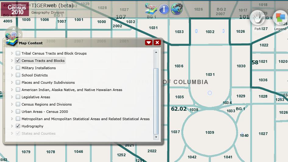
8 Census Tract

9 Census Tract Block Group

10 Census Tract Block Group Census Block
11


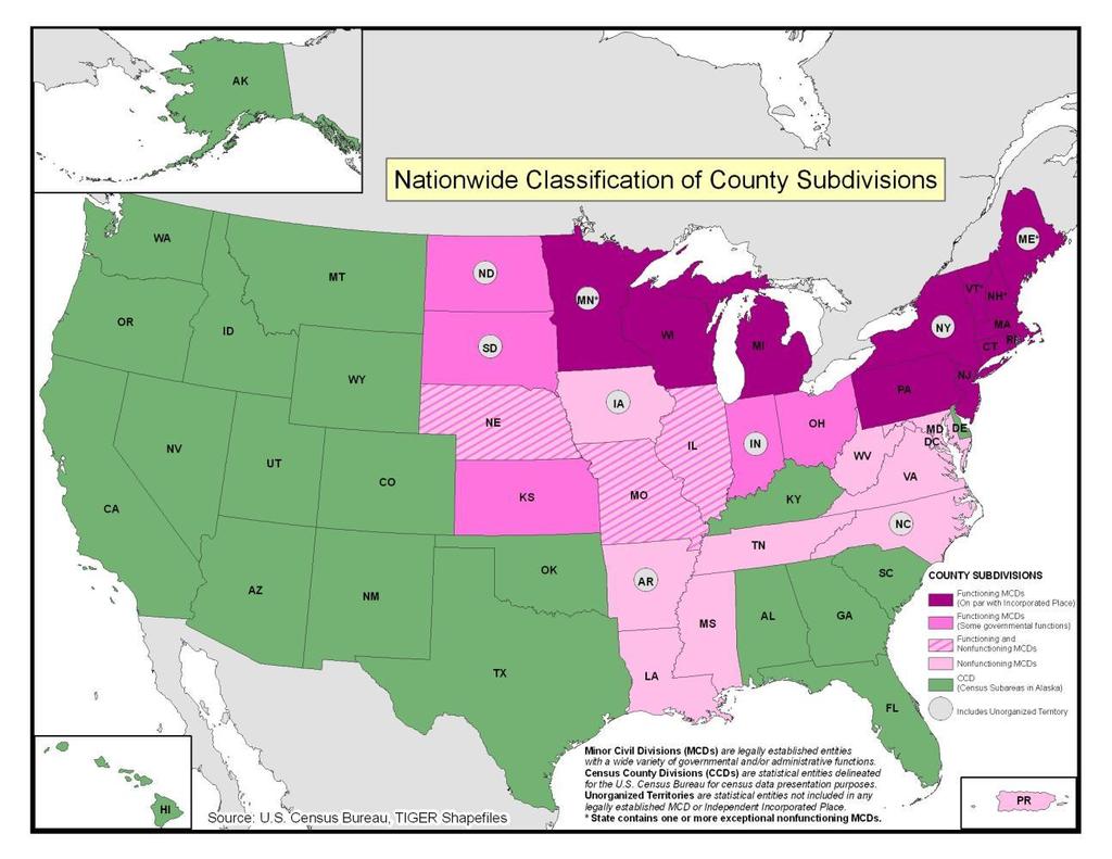
12 White House Census Block


13 White House Census Block
14 2010 Census Redistricting Data (Public Law ) Total: 5 Population of one race: 5 White alone 0 Black or African 5 American alone American Indian and 0 Alaska Native alone Asian alone 0 Native Hawaiian and 0 Other Pacific Islander alone Some Other Race alone 0 Block 1031, Block Group 1, Census Tract 62.02
15
16 Places and County Subdivisions

 over time as")

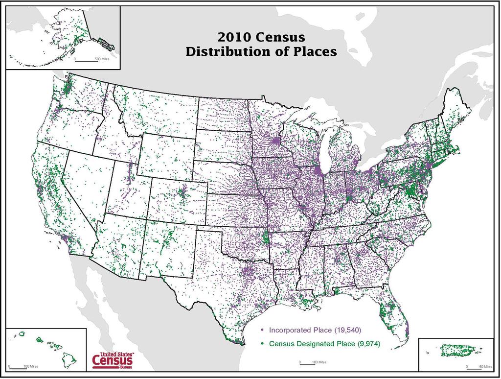
17 Census Bureau Place Concept Places are organic they expand (or contract) over time as population and commercial activity increases (or decreases)

18 Towns/townships are administrative areas; boundaries remain relatively constant as population changes.
19 County Subdivisions Minor Civil Divisions (MCDs) Legally bounded entity Subcounty entities in 29 states, the District of Columbia, Puerto Rico, and the Island Areas May have a formal government with elected officials Census County Divisions (CCDs) Statistical entity Subcounty units that have stable boundaries and recognizable names in 21 states No minimum or maximum population guidelines 19
20 20
21 Places Incorporated Places Legally bounded entity Referred to as cities, boroughs, towns, or villages, depending on the state Some form of local governance (city council, mayor, etc) recognized by the state Census Designated Places (CDPs) Statistical entity Area with a concentration of population, housing, and commercial structures identifiable by name; not within an incorporated place 21
22 22
23 Incorporated Places Includes: Cities Towns (except in the six New England states, New York, and Wisconsin) Villages Boroughs (except in New York and Alaska) Does not include: Towns/townships in the Northeast and Midwest 23
24 Consolidated Cities Within each consolidated city, a balance entity is defined, encompassing the area of the original city and the area outside the dependent incorporated places Augusta-Richmond County consolidated government Augusta-Richmond County (balance) Blythe city Hephzibah city 24

25 Augusta-Richmond County consolidated city 25
26 CDPs encompass a variety of places: Places with same range of social and economic activities as incorporated places, but lack governments: Silver Spring, MD; Tyson s Corner, VA; King of Prussia, PA Special taxation areas: Paradise, NV and other unincorporated towns in Nevada Towns/townships in the Northeast and Midwest that were defined as whole town CDPs: Upper St. Clair, PA; South Park Township, PA Village centers within towns/townships: Amherst Centre, MA Administrative centers/county seats Communities with unique characteristics and needs for data: colonias in TX, NM, AZ, and CA 26
27 Census Designated Places The distinction between legal and statistical as well as incorporated and unincorporated can be fuzzy for some CDPs: Nevada s unincorporated towns have legal status, legally defined boundaries, and have a mayor and town council Whole town CDPs in the Northeast and Midwest are coextensive with towns/townships, which are recognized as municipalities, have legal boundaries and governments Some CDPs (for example, Columbia, MD; Reston, VA) are defined around large associations, incorporated under state law. 27

28 Las Vegas Places
 and CDPs (in blue) cover only a portion of New")
29 New Jersey Places (Census Bureau definition) Census Bureau places cities and boroughs (in red) and CDPs (in blue) cover only a portion of New Jersey
30 New Jersey County Subdivisions (Townships, Cities, and Boroughs) Minor civil divisions, which include all townships, cities, and boroughs, more closely relate to the perception of place in New Jersey.


31 New Jersey places and MCDs Analyzing data for both places and MCDs, however, will result in duplication since cities and boroughs are represented as false MCDs and CDPs cover portions or the entirety of some towns.
32 Economic Place Concept Includes: Incorporated places Towns/townships in the Northeast as well as Michigan, Minnesota, and Wisconsin (the 12 strong-mcd states) Census designated places (except in the 12 strong-mcd states) Balance of county Balance of town Places must encompass either 5,000 or more people, or 5,000 or more jobs 32

33 33 Economic Census Places (2007): 5,000 or more people, or 5,000 or more jobs
34 Data for Places and County Subdivisions Decennial Census American Community Survey Population Estimates Program Economic Census Incorporated Places All All, in 5-year estimates All 5,000 or more persons/jobs Census Designated Places All All, in 5-year estimates Not included 5,000 or more persons/jobs MCDs All All, in 5-year estimates 20 states only 12 states only CCDs All All, in 5-year estimates Not included Not included 34
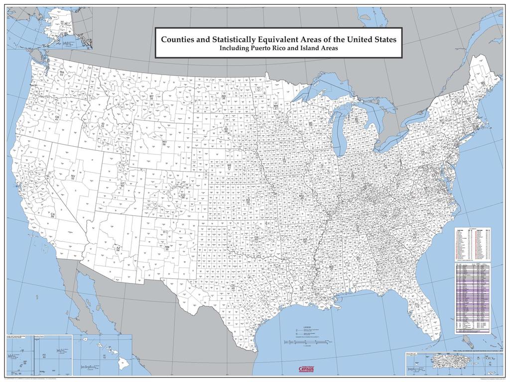
35 Counties and County Equivalents Counties in 48 states Independent Cities in MD, MO, NV, and VA Parishes in Louisiana Cities, Boroughs, Municipality, Census Areas in Alaska Municipios in Puerto Rico Islands and Districts in American Samoa Municipalities in the Northern Marianas Islands in the Virgin Islands District of Columbia and Guam each treated as a county equivalent 35
36
37 Urban and Rural Metropolitan and Micropolitan
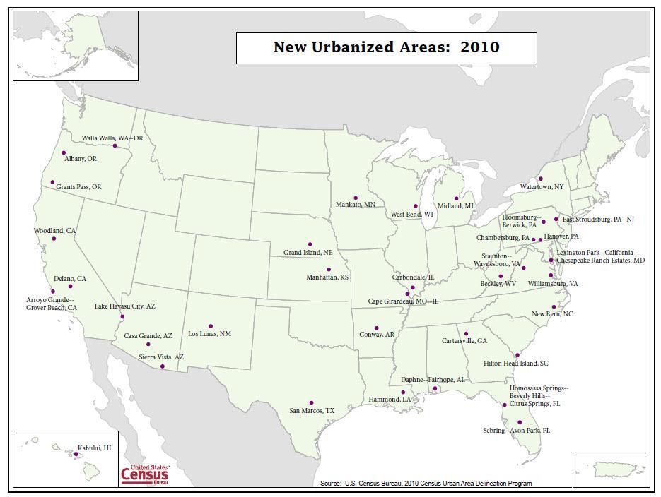
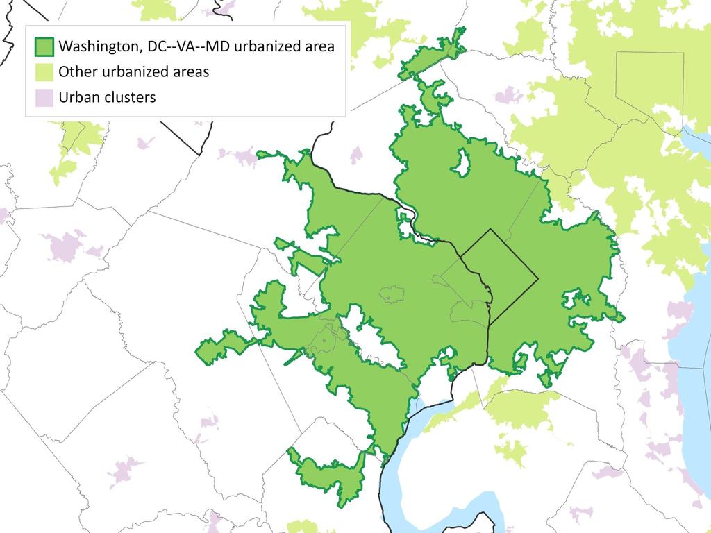
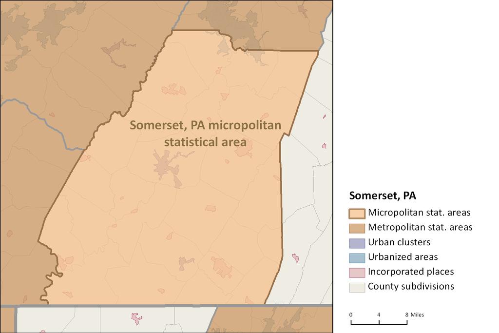
38 Census 2010 Urban Areas Represent densely developed territory, the urban footprint Contain residential, commercial, and other nonresidential urban land uses. Cross all other geographic units within the nation Begin with a dense core of at least 1,000 people per square mile Two types of Urban Areas 1. Urbanized Areas of 50,000 or more people 2. Urban Clusters of 2,500 up to 50,000 people 38
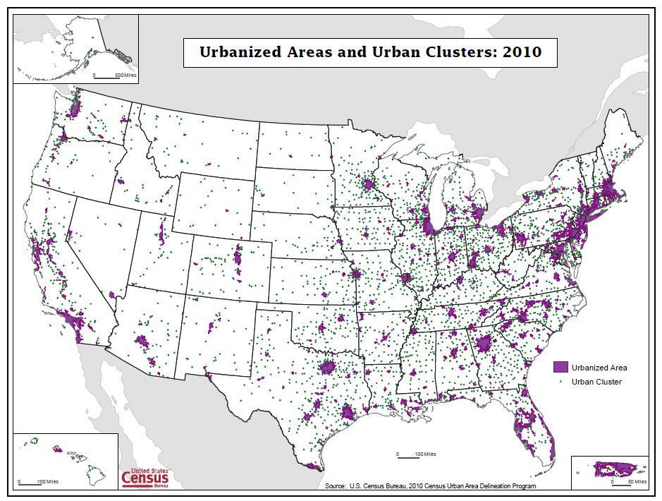
39 39
40 40
41 41

42 42
43 Urban and Rural Populations in the United States in 2010 and Population 2010 Percent 2000 Population 2000 Percent Urban 249,253, ,360, Urbanized Area 219,922, ,323, Urban Cluster 29,331, ,036, Rural 59,492, ,061, Puerto Rico: 93.8% urban, 90.7% urbanized 43
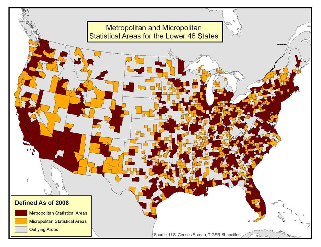
44 Core Based Statistical Areas (CBSA) Defined by U.S. Office of Management and Budget (OMB) National county based set of geographic units CBSA replaced the terms Metropolitan/Micropolitan Areas in Built from county/counties associated with a dense urbanized area or urban cluster of at least 10,000 population Represents an area with a high economic/social integration Integration assessed through commuting flow between adjacent counties and the core.
45 45
46 46
47 Bringing it all together: When we say Somerset, PA what do we really mean?
48
49
50
51
52
53
54 Questions? Geographic area concepts, criteria, codes, and attributes Geographic Standards and Criteria Branch: Geographic products Geographic Products Branch:
The History Behind Census Geography
 The History Behind Census Geography Michael Ratcliffe Geography Division US Census Bureau Kentucky State Data Center Affiliate Meeting August 5, 2016 Today s Presentation A brief look at the history behind
The History Behind Census Geography
 The History Behind Census Geography Michael Ratcliffe Geography Division US Census Bureau Tennessee State Data Center August 8, 2017 Today s Presentation A brief look at the history behind some of the
Spatial Organization of Data and Data Extraction from Maptitude
 Spatial Organization of Data and Data Extraction from Maptitude N. P. Taliceo Geospatial Information Sciences The University of Texas at Dallas UT Dallas GIS Workshop Richardson, TX March 30 31, 2018 1/
Rural Pennsylvania: Where Is It Anyway? A Compendium of the Definitions of Rural and Rationale for Their Use
 Rural Pennsylvania: Where Is It Anyway? A Compendium of the Definitions of Rural and Rationale for Their Use Pennsylvania Office of Rural Health 310 Nursing Sciences Building University Park, PA 16802
Rural Alabama. Jennifer Zanoni. Geography Division U.S. Census Bureau. Alabama State Data Center 2018 Data Conference Tuscaloosa, Alabama
 Rural Alabama Jennifer Zanoni Geography Division U.S. Census Bureau Alabama State Data Center 2018 Data Conference Tuscaloosa, Alabama May 17, 2018 Agenda Census Geography Urban/Rural Definitions County-based
pdcensus2010 User Guide Census Demographics Database
 [Type text] Version 1.0 7 pdcensus2010 User Guide Census Demographics Database An easy-to-use, comprehensive, and up-to-date United States demographics package drawn from U.S. Census Bureau 2010 Census
DRAFT RURAL-URBAN POPULATION CHANGE IN PUERTO RICO, 1990 TO 2000
 DRAFT RURAL-URBAN POPULATION CHANGE IN PUERTO RICO, 1990 TO 2000 Mei-Ling Freeman Geographic Standards and Criteria Branch Geography Division US Census Bureau For presentation at the Western Regional Science
The Census, Urbanized Areas, and Your MPO/RPO
 The Census, Urbanized Areas, and Your MPO/RPO Alex Bond, AICP NADO Rural Transportation Peer Learning Conference August 25, 2011 1 Issues to Discuss Census background Definitions of Census geographies
Census Geography, Geographic Standards, and Geographic Information
 Census Geography, Geographic Standards, and Geographic Information Michael Ratcliffe Geography Division US Census Bureau New Mexico State Data Center Data Users Conference November 19, 2015 Today s Presentation
Boundary and Annexation Survey (BAS)
") Boundary and Annexation Survey (BAS) New Mexico SDC Meeting Chris Wingate Geography Division U.S. Census Bureau 1 Agenda Boundary and Annexation Survey (BAS) BAS Overview American Community Survey (ACS)
Boundary and Annexation Survey (BAS) New Mexico SDC Meeting Chris Wingate Geography Division U.S. Census Bureau 1 Agenda Boundary and Annexation Survey (BAS) BAS Overview American Community Survey (ACS)
2020 Census Participant Statistical Areas Program (PSAP) Standard Statistical Geography Webinar
 Standard Statistical Geography Webinar") 2020 Census Participant Statistical Areas Program (PSAP) Standard Statistical Geography Webinar Agenda PSAP Overview. Schedule. Materials. Standard Statistical Geography Overview. Geographic Update Partnership
2020 Census Participant Statistical Areas Program (PSAP) Standard Statistical Geography Webinar Agenda PSAP Overview. Schedule. Materials. Standard Statistical Geography Overview. Geographic Update Partnership
2010 Census Data Release and Current Geographic Programs. Michaellyn Garcia Geographer Seattle Regional Census Center
 2010 Census Data Release and Current Geographic Programs Michaellyn Garcia Geographer Seattle Regional Census Center 2010 Center of Population Located approximately 2.7 miles northeast of Plato, Missouri
ZIP Code Tabulation Areas For Census 2000
 ZIP Code Tabulation Areas For Census 2000 NCHS, CDC Andrew Flora June 13, 2000 TIGER Operations Branch Geography Division U S C E N S U S B U R E A U Helping You Make Informed Decisions ZIP Code Tabulations
Community Opportunity Map
 Community Opportunity Map User Guide and FAQs UPDATED FEBRUARY 2018 Contents User Guide... 2 Overview... 2 Choosing a location... 3 Search for a city or address... 4 Select a county or ZIP code... 4 Explore
The 2020 Census Geographic Partnership Opportunities
 The 2020 Census Geographic Partnership Opportunities Web Adams Geographer, U.S. Census Bureau New York Regional Office 1 Geographic Partnership Opportunities The 2020 Census Local Update of Census Addresses
Geographic Boundaries of Population Census of Japan 1
 UNITED NATIONS SECRETARIAT ESA/STAT/AC.279/P20 Department of Economic and Social Affairs October 2013 Statistics Division English only United Nations Expert Group on the Integration of Statistical and
Using American Factfinder
 Using American Factfinder What is American Factfinder? American Factfinder is a search engine that provides access to the population, housing and economic data collected by the U.S. Census Bureau. It can
Operational Definitions of Urban, Rural and Urban Agglomeration for Monitoring Human Settlements
 Operational Definitions of Urban, Rural and Urban Agglomeration for Monitoring Human Settlements By Markandey Rai United Nations Human Settlements Programme PO Box-30030 Nairobi, Kenya Abstract The United
Frontier and Remote (FAR) Area Codes: A Preliminary View of Upcoming Changes John Cromartie Economic Research Service, USDA
 Area Codes: A Preliminary View of Upcoming Changes John Cromartie Economic Research Service, USDA") National Center for Frontier Communities webinar, January 27, 2015 Frontier and Remote (FAR) Area Codes: A Preliminary View of Upcoming Changes John Cromartie Economic Research Service, USDA The views
National Center for Frontier Communities webinar, January 27, 2015 Frontier and Remote (FAR) Area Codes: A Preliminary View of Upcoming Changes John Cromartie Economic Research Service, USDA The views
Census Urban Area Comparisons, 2000 to 2010
 THE HONORABLE ROGERS Mayor ANDERSON, Karl Dean, CHAIRMAN Chairman Census Urban Area Comparisons, 2000 to 2010 TCC May 2, 2012 MPOs/RPOs in Tennessee Regional Geographies in Middle TN Nashville MPO Clarksville
2/25/2019. Taking the northern and southern hemispheres together, on average the world s population lives 24 degrees from the equator.
 Where is the world s population? Roughly 88 percent of the world s population lives in the Northern Hemisphere, with about half north of 27 degrees north Taking the northern and southern hemispheres together,
LAND COVER IN OHIO S TOWNSHIPS: AN ANALYSIS OF TOWNSHIP LAND COVER AND POPULATION CHANGE
 THE EXURBAN CHANGE PROJECT REPORT NUMBER EX-3: LAND COVER IN OHIO S TOWNSHIPS: AN ANALYSIS OF TOWNSHIP LAND COVER AND POPULATION CHANGE (FEBRUARY 2002) Prepared by: Jason W. Reece Data Manager & GIS Analyst
Intercity Bus Stop Analysis
 by Karalyn Clouser, Research Associate and David Kack, Director of the Small Urban and Rural Livability Center Western Transportation Institute College of Engineering Montana State University Report prepared
Using Census Public Use Microdata Areas (PUMAs) as Primary Sampling Units in Area Probability Household Surveys
 as Primary Sampling Units in Area Probability Household Surveys") Using Census Public Use Microdata Areas (PUMAs) as Primary Sampling Units in Area Probability Household Surveys Joe McMichael, Patrick Chen RTI International, 1 3040 Cornwallis Road, Research Triangle
Using Census Public Use Microdata Areas (PUMAs) as Primary Sampling Units in Area Probability Household Surveys Joe McMichael, Patrick Chen RTI International, 1 3040 Cornwallis Road, Research Triangle
ESTABLISHING CLASSIFICATION AND HIERARCHY IN POPULATED PLACE LABELING FOR MULTISCALE MAPPING FOR THE NATIONAL MAP
 ESTABLISHING CLASSIFICATION AND HIERARCHY IN POPULATED PLACE LABELING FOR MULTISCALE MAPPING FOR THE NATIONAL MAP W. J. Stroh, S. J. Butzler and C. A. Brewer Department of Geography, The Pennsylvania State
Geographic Products and Data. Improvements in Spatial Accuracy and Accessing Data
 Geographic Products and Data Improvements in Spatial Accuracy and Accessing Data How it Began TIGER was internally developed to support the 1990 Decennial Census operations Used data sources such as USGS
CHANGES IN THE STRUCTURE OF POPULATION AND HOUSING FUND BETWEEN TWO CENSUSES 1 - South Muntenia Development Region
 TERITORIAL STATISTICS CHANGES IN THE STRUCTURE OF POPULATION AND HOUSING FUND BETWEEN TWO CENSUSES 1 - South Muntenia Development Region PhD Senior Lecturer Nicu MARCU In the last decade, a series of structural
Regional Snapshot Series: Transportation and Transit. Commuting and Places of Work in the Fraser Valley Regional District
 Regional Snapshot Series: Transportation and Transit Commuting and Places of Work in the Fraser Valley Regional District TABLE OF CONTENTS Complete Communities Daily Trips Live/Work Ratio Commuting Local
Environmental Analysis, Chapter 4 Consequences, and Mitigation
 Environmental Analysis, Chapter 4 4.17 Environmental Justice This section summarizes the potential impacts described in Chapter 3, Transportation Impacts and Mitigation, and other sections of Chapter 4,
Summary of Natural Hazard Statistics for 2008 in the United States
 Summary of Natural Hazard Statistics for 2008 in the United States This National Weather Service (NWS) report summarizes fatalities, injuries and damages caused by severe weather in 2008. The NWS Office
Problems In Large Cities
 Chapter 11 Problems In Large Cities Create a list of at least 10 problems that exist in large cities. Consider problems that you have read about in this and other chapters and/or experienced yourself.
Improving TIGER, Hidden Costs: The Uncertain Correspondence of 1990 and 2010 U.S. Census Geography
 Improving TIGER, Hidden Costs: The Uncertain Correspondence of 1990 and 2010 U.S. Census Geography Jonathan P. Schroeder ABSTRACT: The U.S. Census Bureau supplies GIS-compatible definitions of census geographic
ADDRESSING TITLE VI AND ENVIRONMENTAL JUSTICE IN LONG-RANGE TRANSPORTATION PLANS
 ADDRESSING TITLE VI AND ENVIRONMENTAL JUSTICE IN LONG-RANGE TRANSPORTATION PLANS Activities from the National Capital Region Transportation Planning Board Sergio Ritacco Transportation Planner 2017 Association
Developing Spatial Data to Support Statistical Analysis of Education
 Developing Spatial Data to Support Statistical Analysis of Education Doug Geverdt National Center for Education Statistics Education Demographic and Geographic Estimates (EDGE) Program 2016 ESRI User Conference
International Workshop on Defining and Measuring Metropolitan Regions (Paris, France, 27 th November, 2006)
") OECD Special Session International Workshop on Defining and Measuring Metropolitan Regions (Paris, France, 27 th November, 2006) Defining an Measuring Metropolitan Areas: A Comparison between Canada and
OECD Special Session International Workshop on Defining and Measuring Metropolitan Regions (Paris, France, 27 th November, 2006) Defining an Measuring Metropolitan Areas: A Comparison between Canada and
H. R heading to fund the award and oversight by the Administrator of grants made under this heading. FEDERAL HIGHWAY ADMINISTRATION
 H. R. 1 92 heading to fund the award and oversight by the Administrator of grants made under this heading. FEDERAL HIGHWAY ADMINISTRATION HIGHWAY INFRASTRUCTURE INVESTMENT For an additional amount for
Neighborhood social characteristics and chronic disease outcomes: does the geographic scale of neighborhood matter? Malia Jones
 Neighborhood social characteristics and chronic disease outcomes: does the geographic scale of neighborhood matter? Malia Jones Prepared for consideration for PAA 2013 Short Abstract Empirical research
Preparing the GEOGRAPHY for the 2011 Population Census of South Africa
 Preparing the GEOGRAPHY for the 2011 Population Census of South Africa Sharthi Laldaparsad Statistics South Africa; E-mail: sharthil@statssa.gov.za Abstract: Statistics South Africa (Stats SA) s Geography
CENTERS OF POPULATION COMPUTATION for the United States
 CENTERS OF POPULATION COMPUTATION for the United States 1950-2010 Geography Division U.S. Census Bureau U.S. Department of Commerce Washington, DC 20233 March 2011 Introduction The following document describes
E/CONF.105/69/CRP.69. China s Campaign to Clean up and Standardize Non-standard Geographical Names
 E/CONF.105/69/CRP.69 23 June 2017 Original: Chinese 11 th United Nations Conference on the Standardization of Geographical Names New York, 8-17 August 2017 Item 9 of the provisional agenda* National standardization
POPULATION ESTIMATION. Process Life Cycle. ensuring the quality of information is an important management objective.
 POPULATION ESTIMATION Process and quality requirements The Census Bureau is the largest statistical agency of the Federal Government. While best known for the decennial census of population and housing,
GIS Lecture 5: Spatial Data
 GIS Lecture 5: Spatial Data GIS 1 Outline Vector Data Formats Raster Data Formats Map Projections Coordinate Systems US Census geographic files US Census data files GIS Data Sources GIS 2 Vector Data Formats
Date: June 19, 2013 Meeting Date: July 5, Consideration of the City of Vancouver s Regional Context Statement
 Section E 1.5 To: From: Regional Planning and Agriculture Committee Lee-Ann Garnett, Senior Regional Planner Planning, Policy and Environment Department Date: June 19, 2013 Meeting Date: July 5, 2013 Subject:
Improving rural statistics. Defining rural territories and key indicators of rural development
 Improving rural statistics Defining rural territories and key indicators of rural development Improving rural statistics Improving Rural Statistics In 2016, the Global Strategy to improve Agricultural
Nevada s Mining Sector
 Nevada s Mining Sector Emsi Q4 2018 Data Set www.economicmodeling.com 1 Industry Summary for Mining 14,475 17.5% $113,786 Jobs (2018) % Change (2010-2018) Avg. Earnings Per Job (2018) 143% above National
ANALYZING CITIES & POPULATION: POPULATION GEOGRAPHY
 ANALYZING CITIES & POPULATION: POPULATION GEOGRAPHY Population Geography Population Geography study of the number, contribution, and distribution of human populations Demography the study of the characteristics
An Introduction to China and US Map Library. Shuming Bao Spatial Data Center & China Data Center University of Michigan
 An Introduction to China and US Map Library Shuming Bao Spatial Data Center & China Data Center University of Michigan Current Spatial Data Services http://chinadataonline.org China Geo-Explorer http://chinageoexplorer.org
A Method for Mapping Settlement Area Boundaries in the Greater Golden Horseshoe
 A Method for Mapping Settlement Area Boundaries in the Greater Golden Horseshoe Purpose This paper describes a method for mapping and measuring the lands designated for growth and urban expansion in the
Oregon Population Forecast Program
 Oregon Population Forecast Program Regional Forecast Meeting October 2, 2015 Presentation by Population Forecast Program Team Hood River County Oregon Population Forecast Program Project Team Xiaomin Ruan,
Utilizing Data from American FactFinder with TIGER/Line Shapefiles in ArcGIS
 Utilizing Data from American FactFinder with TIGER/Line Shapefiles in ArcGIS Web Adams, GISP Data Dissemination Specialist U.S. Census Bureau New York Regional Office 1 What We Do Decennial Census Every
Enrollment at a Glance Fall 2015
 1. Number of Students Enrolled at Tenth Day of Fall Term 2011 2012 2013 2014 2015 3,705 ( 100.0% ) 3,626 ( 100.0% ) 3,706 ( 100.0% ) 3,746 ( 100.0% ) 3,891 ( 100.0% ) New 1 1,051 ( 28.4% ) 1,063 ( 29.3%
Bureau of Economic and Business Research May 29, Measuring Population Density for Counties in Florida
 Bureau of Economic and Business Research May 29, 2015 Measuring Population Density for Counties in Florida By: Stefan Rayer, PhD; Ying Wang, PhD https://www.bebr.ufl.edu/content/measuring-population-density-counties-florida
Inclusion of Non-Street Addresses in Cancer Cluster Analysis
 Inclusion of Non-Street Addresses in Cancer Cluster Analysis Sue-Min Lai, Zhimin Shen, Darin Banks Kansas Cancer Registry University of Kansas Medical Center KCR (Kansas Cancer Registry) KCR: population-based
Do the Causes of Poverty Vary by Neighborhood Type?
 Do the Causes of Poverty Vary by Neighborhood Type? Suburbs and the 2010 Census Conference Uday Kandula 1 and Brian Mikelbank 2 1 Ph.D. Candidate, Maxine Levin College of Urban Affairs Cleveland State
Establishing Classification and Hierarchy in Populated Place Labeling for Multiscale Mapping for The National Map
 Establishing Classification and Hierarchy in Populated Place Labeling for Multiscale Mapping for The National Map Wesley Stroh, Stephen Butzler and Cynthia Brewer Gould Center, Geography Pennsylvania State
The Rural Health Workforce. Policy Brief Series. Data and Issues for Policymakers in: Washington Wyoming Alaska Montana Idaho
 The Health Workforce Data and Issues for Policymakers in: Washington Wyoming Alaska Montana Idaho Policy Brief Series ISSUE #1: THE RURAL HEALTH WORKFORCE: CHALLENGES AND OPPORTUNITIES ISSUE #2: THE RURAL
Passenger Transportation Networks & Urbanization Level: A Comparison of Classification Schemes
 Pyrialakou, Nlenanya, Gkritza 0 0 Passenger Transportation Networks & Urbanization Level: A Comparison of Classification Schemes V. Dimitra Pyrialakou (Corresponding author) Graduate Research Assistant,
Geographic Locations Survey of Clinical Psychologists in Canada
 Geographic Locations Survey of Clinical Psychologists in Canada A publication of the Canadian Psychological Association. 1999 To order print copies, click here! Print copies of this CPA document are available
Regional Transit Development Plan Strategic Corridors Analysis. Employment Access and Commuting Patterns Analysis. (Draft)
") Regional Transit Development Plan Strategic Corridors Analysis Employment Access and Commuting Patterns Analysis (Draft) April 2010 Contents 1.0 INTRODUCTION... 4 1.1 Overview and Data Sources... 4 1.2
Regional Transit Development Plan Strategic Corridors Analysis Employment Access and Commuting Patterns Analysis (Draft) April 2010 Contents 1.0 INTRODUCTION... 4 1.1 Overview and Data Sources... 4 1.2
The Governance of Land Use
 The planning system The Governance of Land Use United Kingdom Levels of government and their responsibilities The United Kingdom is a unitary state with three devolved governments in Northern Ireland,
Geospatial Analysis of Job-Housing Mismatch Using ArcGIS and Python
 Geospatial Analysis of Job-Housing Mismatch Using ArcGIS and Python 2016 ESRI User Conference June 29, 2016 San Diego, CA Jung Seo, Frank Wen, Simon Choi and Tom Vo, Research & Analysis Southern California
City definitions. Sara Ben Amer. PhD Student Climate Change and Sustainable Development Group Systems Analysis Division
 City definitions Sara Ben Amer PhD Student Climate Change and Sustainable Development Group Systems Analysis Division sbea@dtu.dk Contents 1. Concept of a city 2. Need for the city definition? 3. Challenges
Proposal for International Workshop on Defining and Measuring Metropolitan Regions. II. Definition and Measurement of Metropolitan Area in Japan
 November 20, 2006 Proposal for International Workshop on Defining and Measuring Metropolitan Regions Japanese Government I. Introduction II. Definition and Measurement of Metropolitan Area in
A. Geography Students know the location of places, geographic features, and patterns of the environment.
 Learning Targets Elementary Social Studies Grade 5 2014-2015 A. Geography Students know the location of places, geographic features, and patterns of the environment. A.5.1. A.5.2. A.5.3. A.5.4. Label North
Updating the Urban Boundary and Functional Classification of New Jersey Roadways using 2010 Census data
 Updating the Urban Boundary and Functional Classification of New Jersey Roadways using 2010 Census data By: Glenn Locke, GISP, PMP 1 GIS-T May, 2013 Presentation Overview Purpose of Project Methodology
Transportation Models and Data Initiative
 New York Metropolitan Transportation Council The Metropolitan Planning Organization Transportation Models and Data Initiative Technical Memorandum Tasks 11.4 Development of Best Practice Regional Zone
ONE REGION: PLANNING FOR A STRONG AND JUST METROPOLIS. NYLON # 14: Regional Planning. October 31, 2018
 DRAFT ONE REGION: PLANNING FOR A STRONG AND JUST METROPOLIS NYLON # 14: Regional Planning October 31, 2018 Carolyn Grossman Meagher, Director, Regional Planning Division the New Yorker March 1976. A New
Unit 1 Test - Version A
 Unit 1 Test - Version A 1. Approximately, how many degrees of longitude equal one time zone change? a. 5 b. 10 c. 15 d. 20 e. 25 2. The city of Lewisville has a population of 1,000 people living in 100
Guide to the Data-Driven Planning Toolkit in CPD Maps
 The econ Planning Suite: Guide to the Data-Driven Planning Toolkit in CPD Maps Version: April 2014 TABLE OF CONTENTS Introduction... 1 The Data-Driven Planning Toolkit... 3 Overview of the Basic Model...
GIS-Based Analysis of the Commuting Behavior and the Relationship between Commuting and Urban Form
 GIS-Based Analysis of the Commuting Behavior and the Relationship between Commuting and Urban Form 1. Abstract A prevailing view in the commuting is that commuting would reconstruct the urban form. By
Council Workshop on Neighbourhoods Thursday, October 4 th, :00 to 4:00 p.m. Burlington Performing Arts Centre
 Council Workshop on Neighbourhoods Thursday, October 4 th, 2012 1:00 to 4:00 p.m. Burlington Performing Arts Centre Agenda Introductions Warm-Up Exercise Presentation Exercise Neighbourhood Planning Break
Town Lines 2007 Municipal Officials & Statistics
 Town Lines 2007 Municipal Officials & Statistics 63 64 TOP PHOTO Nay Aug Gorge, Scranton BOTTOM PHOTO Moffat Estate, Covington Township Municipal Center PHOTOS ON PAGE 63 From top, left to right Ransom
PERCEPTION and Focus on Maps. Focus on Maps 8/29/2014. English and Dutch Maps from the 1600s and 1680 British Maps of N. Am.
 PERCEPTION English and Dutch Maps from the 600s The Nature of New York Dutch67 Prof. Anthony Grande English 67 Copyright 04 AFG 676 and 680 British Maps of N. Am. 70 and 776 4 Focus on Maps Maps are geographers
BIG IDEAS. Area of Learning: SOCIAL STUDIES Urban Studies Grade 12. Learning Standards. Curricular Competencies
 Area of Learning: SOCIAL STUDIES Urban Studies Grade 12 BIG IDEAS Urbanization is a critical force that shapes both human life and the planet. The historical development of cities has been shaped by geographic,
Chapter 2: Description of Planning Area
 2020 Facilities Plan Facilities Plan Report Chapter 2: Description of Planning Area 2.1 Introduction This chapter describes Milwaukee Metropolitan Sewerage District s (MMSD) planning area and existing
GIS Analysis of Crenshaw/LAX Line
 PDD 631 Geographic Information Systems for Public Policy, Planning & Development GIS Analysis of Crenshaw/LAX Line Biying Zhao 6679361256 Professor Barry Waite and Bonnie Shrewsbury May 12 th, 2015 Introduction
LOCAL GOVERNMENT ADMINISTRATION SERIES
 Public Policy Research Center University of Missouri St. Louis LOCAL GOVERNMENT ADMINISTRATION SERIES ISSUE #3 MARCH 2017 THE GOVERNOR IN GOVERNANCE: KEEPING THE PACE by Mark Tranel, Director, Public Policy
Presentation to the National Association of Counties Large Urban County Caucus 2016 Innovation Symposium. New York, NY November 2016
 Presentation to the National Association of Counties Large Urban County Caucus 2016 Innovation Symposium New York, NY November 2016 Large counties are leading a shift in the country s economic landscape
Population Density. Population density: A measure of how crowded a place is.
 Population Density Population density: A measure of how crowded a place is. Formula: Population Density = Population Total Area km 2 Overall Canada has a low population density of about 3 people per km
Nevada s Mining Sector
 Nevada s Mining Sector Industry Summary for Nevada s Mining Sector 14,645 53.0% $107,341 Jobs () % Change (2004-) Avg. Earnings Per Job () 99% above National average Nation: 63.6% Nation: $117,598 Industry
MEASURING RACIAL RESIDENTIAL SEGREGATION
 MEASURING RACIAL RESIDENTIAL SEGREGATION Race Relations Institute Fisk University 1000 Seventeenth Ave. North Nashville, Tennessee 37208 615/329-8575 WHERE WE LIVE: THE COLOR LINE The color line is carved
CRP 608 Winter 10 Class presentation February 04, Senior Research Associate Kirwan Institute for the Study of Race and Ethnicity
 CRP 608 Winter 10 Class presentation February 04, 2010 SAMIR GAMBHIR SAMIR GAMBHIR Senior Research Associate Kirwan Institute for the Study of Race and Ethnicity Background Kirwan Institute Our work Using
Policy Paper Alabama Primary Care Service Areas
 Aim and Purpose Policy Paper Alabama Primary Care Service Areas Produced by the Office for Family Health Education & Research, UAB School of Medicine To create primary care rational service areas (PCSA)
ITEM 11 Information June 20, Visualize 2045: Update to the Equity Emphasis Areas. None
 ITEM 11 Information June 20, 2018 Visualize 2045: Update to the Equity Emphasis Areas Staff Recommendation: Issues: Background: Briefing on the TPB-approved methodology to update the Equity Emphasis Areas
Annual Performance Report: State Assessment Data
 Annual Performance Report: 2005-2006 State Assessment Data Summary Prepared by: Martha Thurlow, Jason Altman, Damien Cormier, and Ross Moen National Center on Educational Outcomes (NCEO) April, 2008 The
Transit Development Planning: Flagler County Needs Assessment & Implementation Program INTERGOVERNMENTAL MEETING OF FLAGLER COUNTY APRIL 13, 2010
 Transit Development Planning: nty Needs Assessment & Implementation Program INTERGOVERNMENTAL MEETING OF FLAGLER COUNTY APRIL 13, 2010 Rob Gregg & Justin Begley, Center for Urban Transportation Research
GUIDE FOR ENVIRONMENTAL JUSTICE ANALYSIS WITH THE ENVIRONMENTAL IMPACT ANALYSIS PROCESS (EIAP) Department of the Air Force
 Department of the Air Force") GUIDE FOR ENVIRONMENTAL JUSTICE ANALYSIS WITH THE ENVIRONMENTAL IMPACT ANALYSIS PROCESS (EIAP) Department of the Air Force November 1997 TABLE OF CONTENTS INTRODUCTION............... 1 FLOWCHART STEP 1:
GUIDE FOR ENVIRONMENTAL JUSTICE ANALYSIS WITH THE ENVIRONMENTAL IMPACT ANALYSIS PROCESS (EIAP) Department of the Air Force November 1997 TABLE OF CONTENTS INTRODUCTION............... 1 FLOWCHART STEP 1:
May kindly Tim Page prepare the Bulgaria page header with the same design as the others? Bulgaria Urban Region of Sofia
 May kindly Tim Page prepare the Bulgaria page header with the same design as the others? Bulgaria Urban Region of Sofia National Planning Context Urban Region of Sofia Geography Statistics Trends Historical
Small-Area Population Forecasting Using a Spatial Regression Approach
 Small-Area Population Forecasting Using a Spatial Regression Approach Guangqing Chi and Paul R. Voss Applied Population Laboratory Department of Rural Sociology University of Wisconsin-Madison Extended
Developed new methodologies for mapping and characterizing suburban sprawl in the Northeastern Forests
 Development of Functional Ecological Indicators of Suburban Sprawl for the Northeastern Forest Landscape Principal Investigator: Austin Troy UVM, Rubenstein School of Environment and Natural Resources
Regional Growth Strategy Regional Staff Committee
 Regional Growth Strategy Regional Staff Committee June 21, 2018 1 Overview Summary of June Growth Management Policy Board Regional Growth Strategy Objectives Regional Geographies Regional Growth Strategy
AGEC 603. Stylized Cited Assumptions. Urban Density. Urban Density and Structures. q = a constant density the same throughout
 AGEC 603 Urban Density and Structures Stylized Cited Assumptions q = a constant density the same throughout c = constant structures the same throughout Reality housing is very heterogeneous Lot size varies
Establishing Classification and Hierarchy in Populated Place Labeling for Multiscale Mapping for The National Map
 Establishing Classification and Hierarchy in Populated Place Labeling for Multiscale Mapping for The National Map Stephen Butzler, Cynthia Brewer and Jim Thatcher RA: Doug Minnigh Gould Center, Geography
Population Trends Along the Coastal United States:
 Coastal Trends Report Series Population Trends Along the Coastal United States: 1980-2008 U.S. Department of Commerce National Oceanic and Atmospheric Administration National Ocean Service Assessing the
FHWA Planning Data Resources: Census Data Planning Products (CTPP) HEPGIS Interactive Mapping Portal
 HEPGIS Interactive Mapping Portal") FHWA Planning Data Resources: Census Data Planning Products (CTPP) HEPGIS Interactive Mapping Portal Jeremy Raw, P.E. FHWA, Office of Planning, Systems Planning and Analysis August 2017 Outline Census
FHWA Planning Data Resources: Census Data Planning Products (CTPP) HEPGIS Interactive Mapping Portal Jeremy Raw, P.E. FHWA, Office of Planning, Systems Planning and Analysis August 2017 Outline Census
Direct Selling Association 1
 Total Number of Firms 1,100 104 58 46 14 41 22 27 44 60 1 U.S. Sales Volume & Growth 1 Average Retail Sales per Firm ($thousands) 2015 $32,836 $210,572 $320,820 $69,556 $1,041 $11,788 $100,216 $721,897
NSF CNH-Ex # Political Fragmentation Indicator Database (Version 3.01)
") NSF CNH-Ex #1114931 Political Fragmentation Indicator Database (Version 3.01) February 2014 NSF CNH-Ex #1114931 Project Team Jae Hong Kim (jaehk6@uci.edu) Timothy Keane (whisker@ksu.edu) 1 Introduction
NSF CNH-Ex #1114931 Political Fragmentation Indicator Database (Version 3.01) February 2014 NSF CNH-Ex #1114931 Project Team Jae Hong Kim (jaehk6@uci.edu) Timothy Keane (whisker@ksu.edu) 1 Introduction
A Case Study of Regional Dynamics of China 中国区域动态案例研究
 A Case Study of Regional Dynamics of China 中国区域动态案例研究 Shuming Bao Spatial Data Center & China Data Center University of Michigan 1:00 PM - 2:00 PM, Tue, Feb 6, 2018 EST USA A Case Study of Regional Dynamics
Variables and Variable De nitions
 APPENDIX A Variables and Variable De nitions All demographic county-level variables have been drawn directly from the 1970, 1980, and 1990 U.S. Censuses of Population, published by the U.S. Department
Table 6 - Demographic Yearbook 2011
 Table 6 - Demographic Yearbook 2011 Table 6 presents total population by sex for as many years as possible between 2002 and 2011, as well as urban population as available. Description of variables: Data