The Cultural Landscape Eleventh Edition
|
|
|
- Percival Gaines
- 5 years ago
- Views:
Transcription

1 Chapter 13 Lecture The Cultural Landscape Eleventh Edition Urban Patterns Matthew Cartlidge University of Nebraska-Lincoln
2 Key Issues Why do services cluster downtown? Where are people distributed within urban areas? Why are urban areas expanding? Why do cities face challenges?
3 Learning Outcomes : Describe the three types of services found in a CBD : Explain the three-dimensional nature of a CBD : Describe the concentric zone, sector, and multiple nuclei models : Analyze how the three models help to explain where people live in an urban area.
4 Learning Outcomes : Describe how the three models explain patterns in European cities : Describe how the three models explain patterns in cities in developing countries Describe the history of development of cities in developing countries : State three definitions of urban settlements : Describe how metropolitan areas contain many local governments and overlap with each other.
5 Learning Outcomes : Identify historical and contemporary patterns of suburban expansion : Explain two ways in which suburbs are segregated : Describe the impact of motor vehicles in urban areas : State benefits and limitations of public transportation : Describe recent and possible future improvements in vehicles.
6 Learning Outcomes : Describe the processes of deterioration and gentrification in cities : Explain the problems of a permanent underclass and culture of poverty in cities : Describe the difficulties that cities face in paying for services, especially in a recession.
7 Why Do Services Cluster Downtown? CBD Land Uses The central business district takes up less than 1 percent of the urban land area, yet contains a large percentage of the services offered in the city. Services offered in the CBD can be divided into three types: 1. Public Services Examples: city hall, courts, county and state agencies, and libraries.. Centrally located for ease of accessibility to all residents Sports centers and conventions centers are often downtown to stimulate commerce in the CBD.
8 Why Do Services Cluster Downtown? CBD Land Uses Services offered in the CBD can be divided into three types cont d: 2. Business Services Examples: advertising agencies, banks, financial institutions, and law firms. Proximity to other service providers for businesses promotes collaboration and face-to-face meetings.
9 Why Do Services Cluster Downtown? CBD Land Uses Services offered in the CBD can be divided into three types cont d.: 3. Consumer Services Historically, three types of retail services clustered in a CBD.» Retailers with a high threshold» Retailers with a high range» Retailers that served people who worked in the CBD Changing shopping habits and a shift of the more affluent to the suburbs have reduced the importance of retail services in the CBD.

10 Insert fig. 13-2
11 Why Do Services Cluster Downtown? Competition for Land in the CBD High demand for the limited space in the CBD has encouraged vertical development. Underground CBD Inadequate space exists above ground for the needed dense network of telephone, electric, and broadband cables, thus they are placed underground and out of sight. Underground passages can segregate pedestrians from motor vehicles and shield them from harsh winter weather. Skyscrapers Demand for space in CBDs has made high-rise structures economically feasible.
12 Where Are People Distributed Within Urban Areas? Models of Urban Structure Concentric Zone Model Created in 1923 by sociologist E.W. Burgess First model to explain the distribution of different social groups within urban areas Model suggests that a city grows outward from a central area in a series of concentric rings. CBD: innermost ring where nonresidential activities occur A Zone in Transition: area eventually consumed by CBD Zone of Working-Class Homes: modest, older houses Zone of Better Residence: newer, larger houses for middle-class families Commuter Zone: beyond the continuous built-up
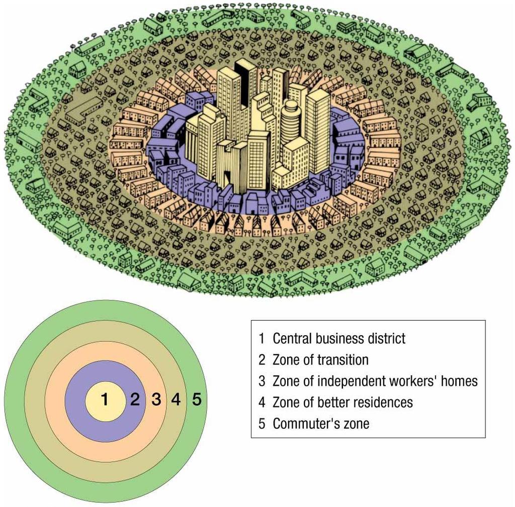
13 Fig. 13-9
14 Where Are People Distributed Within Urban Areas? Models of Urban Structure Sector Model Created by land economist Homer Hoyt in Model that posits a city develops in a series of sectors, not rings. As a city grows, activities expand outward in a wedge, or sector, from the center.

15 Fig
16 Where Are People Distributed Within Urban Areas? Models of Urban Structure Multiple Nuclei Model Created by geographers C. D. Harris and E. L. Ullman in 1945 Model posits that a city is a complex structure that includes more than one center around which activities revolve. Examples» Ports» Universities» Airports» Parks

17 Fig
18 Where Are People Distributed Within Urban Areas? Geographic Applications of the Models The models of urban structure help us understand where people with different social characteristics tend to live and why. Critics point out that the models are too simple and may be too dated to explain contemporary urban patterns in the U.S. or in other countries. Combining the models help geographers explain where different types of people live in a city. They suggest that most people prefer to live near others who have similar characteristics.
19 Where Are People Distributed Within Urban Areas? Geographic Applications of the Models Examples Concentric Zone Model Families in newer houses tend to live in an outer ring Families in older houses tend to live in an inner ring Sector Model Given two families who own their homes, the family with the higher income will not live in the same sector as the family with a lower income. Nuclei Model People with same ethnic background are likely to live near each other.

20 Figs on separate slides

21 Figs on separate slides

22 Figs on separate slides
23 Where Are People Distributed Within Urban Areas? Applying the Models Outside North America Applying the Models in Europe Sectors In Europe, the wealthy still live in the inner portions of the upper-class sector, not just in the suburbs like most of the affluent in the U.S. Concentric Zones In Europe, most of the newer housing built in the suburbs is high-rise apartment buildings for low-income people and recent immigrants, unlike the U.S.

24 Figs
25 Where Are People Distributed Within Urban Areas? Applying the Models Outside North America Applying the Models in Developing Countries The poor are accommodated in suburbs. The wealthy live near the center of the city, as well as in a sector extending from the center.

26 Figs
27 Where Are People Distributed Within Urban Areas? Stages of Cities in Developing Countries Precolonial Cities Before the Europeans established colonies, most people lived in rural settlements. There were but a few principal cities in Latin America, Africa, and Asia. Examples In present-day Mexico, the Aztecs built the city Tenochtitlan, where present-day Mexico City is located. Colonial Cities When European colonization gained control of Latin America, Asia, and Africa, they expanded the existing cities to provide colonial services.

28 Figs
29 Where Are People Distributed Within Urban Areas? Stages of Cities in Developing Countries Colonial Cities cont d. Examples include:» Administration» Military Command» International Trade» Housing for European Settlers Cities Since Independence Following independence, cities have become the focal points of change. Millions of migrants have arrived to them in search of work. In some cities, such as Mexico City, previous social patterns from the previous century were reinforced.

30 Figs
31 Why Are Urban Areas Expanding? Defining Urban Settlements Several definitions have been created to characterize cities and their suburbs. 1. The term city defines an urban settlement that has been legally incorporated into an independent, self-governing unit. In the U.S., these urban settlements are sometimes known as a central city.

32 Figs
33 Why Are Urban Areas Expanding? Defining Urban Settlements cont d. 2. An urban area consists of a dense core of census tracts, densely settled suburbs, and low-density land that links the dense suburbs with the core. The census recognizes two types of urban areas: 1. An urbanized area is an urban area with at least 50,000 inhabitants. 2. An urban cluster is an urban area with between 2,500 and 50,000 inhabitants.
34 Why Are Urban Areas Expanding? Defining Urban Settlements cont d. 3. The U.S. Bureau of the Census has created a method of measuring the functional area of a city, known as the metropolitan statistical area (MSA). It includes: An urbanized area with a population of at least 50,000 The county within which the city is located Adjacent counties with a high population density and a large percentage of residents working in the central city s county.
35 Why Are Urban Areas Expanding? Overlapping Metropolitan Areas Some adjacent MSAs overlap so that they now form one continuous urban complex. Example: Extending north of Boston to South of Washington D.C., geographer Jean Gottmann named this region Megalopolis, a Greek word meaning great city. Local Government Fragmentation Most U.S. metropolitan areas have a council of government, which is a cooperative agency consisting of various local government representatives. Purpose may be to do some overall planning for the area that cannot be performed by a single local government.
36 Why Are Urban Areas Expanding? Annexation The process of legally adding land area to a city is annexation. Many U.S. cities grew rapidly in the 19 th century, because they offered better services than available in the rural countryside (e.g. water supply, sewage disposal, etc.) Density Gradient U.S. tend to become less and less dense as one ventures farther from the city s center; this phenomenon is known as the density gradient.

37 Figs
38 Why Are Urban Areas Expanding? The Cost of Suburban Sprawl A flattening of the density gradient for a metropolitan area means that its people and services are spread out over a larger area. U.S. suburbs are characterized by sprawl, the progressive spread of development over the landscape. Suburban Segregation The modern residential suburb is segregated in two ways: 1.Social Class Similarly priced houses are typically built in close proximity to one another, thus attracting a specific range of income earners.

39 Figs
40 Why Are Urban Areas Expanding? Suburban Segregation The modern residential suburb is segregated in two ways cont d.: 2. Land Uses Residents are separated from commercial and manufacturing activities that are confined to compact, distinct areas.» Zoning ordinances enacted in the early 20 th century have contributed most notably to the segregation of land uses associated with suburban areas.
41 Why Are Urban Areas Expanding? Urban Transportation Motor Vehicles Cars and trucks permitted large-scale development of suburbs at greater distances from the city center. Motor vehicles use a considerable amount of space in U.S. cities. An average city allocated about ¼ of its land to roads and parking lots. Multilane freeways cut a 23-meter (75-foot) path through the heart of a city, and elaborate interchanges consume even more space. Valuable land in the central city is devoted to parking cars and trucks.
42 Why Are Urban Areas Expanding? Urban Transportation The Car of the Future Motor vehicles are one of the greatest challenges to reducing pollution in congested urban areas. Automakers are scrambling to bring alternative-fuel vehicles to the market. Diesel» Diesel engines burn fuel more efficiently.» Biodiesel fuel can be produced partly with vegetable oils or recycled restaurant grease. Hybrid» Energy that would be otherwise wasted when coasting and braking is reduced, because an electric engine takes over during those instances.
43 Why Are Urban Areas Expanding? Urban Transportation The Car of the Future Ethanol» Fuel made by distilling crops, such as sugarcane, corn, and soybeans.» Critics question whether the amount of energy put into growing the crops is not equal to, if not more than, the amount of energy derived from them as fuel. Plug-In Hybrid» Electric motor supplies the power at all speeds.» Gas engine can recharge the battery, as well as plugging the car into an electrical outlet. Hydrogen Fuel Cell» Hydrogen forced through a PEM (polymer electrolyte membrane or proton exchange membrane) combines with oxygen from the air, producing an electric charge.

44 Fig

45 Fig
46 Why Are Urban Areas Expanding? Urban Transportation Public Transit Benefits In larger cities, public transit is better suited than motor vehicles to move large numbers of people, because each transit traveler takes up less space. More cost effective than privately operated vehicles Emits relatively less pollutants than privately operated vehicles More energy efficient than privately operated vehicles Limitations Most people in the U.S. overlook the benefits of public transit, because they place higher value on the privacy and flexibility of schedule offered by a car. Not offered in most U.S. cities

47 Fig
48 Why Do Cities Face Challenges? Changing Urban Physical Geography The Process of Deterioration Filtering Large houses in older neighborhoods are subdivided into smaller dwellings for low-income families, through a process known as filtering. Over time, landlords cease maintaining the properties when they are no longer economically feasible. Redlining Some banks engage in redlining- drawing lines on a map to identify areas in which they will refuse to loan money to purchase or to fix up a house. Redlining is illegal but difficult to enforce
49 Why Do Cities Face Challenges? Changing Urban Physical Geography The Process of Deterioration Public Housing During the mid-twentieth century, many substandard innercity houses were demolished and replaced with public housing- housing reserved for low-income households, who must pay 30 percent of their income for rent. A housing authority, established by the local government, manages the buildings, and the federal government pays for all expenses not covered by rent. Most of the high-rise public housing projects built in the U.S. and Europe at this time are now considered unsatisfactory for families with children.

50 Fig
51 Why Do Cities Face Challenges? Changing Urban Physical Geography Gentrification Gentrification is the process by which middle-class people move into deteriorated inner-city neighborhoods and renovate the housing. Most U.S. cities have at least one substantially renovated inner-city neighborhood where middleclass people live. Middle class-families attracted by some of the following:» Houses may have more architectural character than those in the suburbs.» Proximity to cultural and recreational activities» Commuting time reduced to CBD

52 Fig
53 Why Do Cities Face Challenges? Changing Urban Social Geography Underclass Inner-city residents are frequently referred to as permanent underclass, because they are trapped in an unending cycle of economic and social problems. Suffers from relatively higher rates of unemployment, alcoholism, drug addiction, illiteracy, juvenile delinquency, and crime. Children often attend deteriorated schools Affordable housing is difficult to secure Tend to ignore good learning habits, regular school attendance, and completion of homework; the tendencies needed to elevate one s self out of the underclass.
54 Why Do Cities Face Challenges? Changing Urban Social Geography Culture of Poverty Inner-city residents are trapped as a permanent underclass, because they live in a culture of poverty. Characterized by: Unwed mothers giving birth to ¾ of the babies in the U.S. inner-city neighborhoods ¾ of children in the inner city live with only one parent Relatively higher usage of drugs.
55 Why Do Cities Face Challenges? Urban Economic Challenges The Eroding Tax Base Low-income inner-city residents require public services, but they pay little of the taxes needed to fund the public services. Cities have two choices to close the gap between the cost of operating public services and the funding made available by taxing. 1. Reduce Services 2. Raise Tax Revenues
56 Why Do Cities Face Challenges? Urban Economic Challenges The Impact of the Recession Housing market collapse in 2008 was one of principal causes of the severe recession. Lower assessed values of houses led to lower tax revenues acquired from property taxes. When borrowers cease paying their mortgages, lenders can take over the property in what is called a foreclosure.

57 Fig
58 Summary Services, especially public and business services, cluster in the CBD; some consumer services, especially leisure, are in the CBD. Three models help to explain where different groups of people live within urban areas. Urban growth has been primarily focused on suburbs that surround older cities. Cities face physical, social, and economic difficulties, but some improvements also occurred.
Chapter 13: Urban Patterns The Cultural Landscape:
 Chapter 13: Urban Patterns The Cultural Landscape: An Introduction to Human Geography Key Issues Why do services cluster downtown? Where are people distributed within urban areas? Why are urban areas expanding?
Contemporary Human Geography 3 rd Edition
 Chapter 13 Lecture Contemporary Human Geography 3 rd Edition Chapter 13: Urban Patterns Marc Healy Elgin Community College 13.1 The Central Business District The best-known and most visually distinctive
MULTIPLE CHOICE. Choose the one alternative that best completes the statement or answers the question.
 AP Test 13 Review Name MULTIPLE CHOICE. Choose the one alternative that best completes the statement or answers the question. 1) Compared to the United States, poor families in European cities are more
Key Issue 1: Why Do Services Cluster Downtown?
 Key Issue 1: Why Do Services Cluster Downtown? Pages 460-465 1. Define the term CBD in one word. 2. List four characteristics of a typical CBD. Using your knowledge of services from chapter 12, define
Key Issue 1: Why Do Services Cluster Downtown?
 Key Issue 1: Why Do Services Cluster Downtown? Pages 460-465 ***Always keep your key term packet out whenever you take notes from Rubenstein. As the terms come up in the text, think through the significance
Ch. 13: Urban Patterns
 Ch. 13: Urban Patterns Name: Introduction & Case Study (p. 430-432) 1. Describe some differences between urban and rural environments. 2. Why do MDCs have a higher percentage of people living in urban
c. What is the most distinctive above ground result of high land costs and intensive land use? i. Describe the vertical geography of a skyscraper?
 AP Human Geography Unit 7b Guided Reading: Urban Patterns and Social Issues Mr. Stepek Key Issue #1: Why Do Services Cluster Downtown? (Rubenstein p 404 410) 1. What is the CBD? What does it contain and
Chapter 13 Urban Patterns Pearson Education, Inc.
 Chapter 13 Urban Patterns Urban Patterns: Key Issues 1. Why Are Downtowns Distinctive? 2. Where Are People Distributed in Urban Areas? 3. Why Do Urban Areas Expand? 4. Why Do Cities Face Sustainability
Contemporary Human Geography 3 rd Edition
 Contemporary Human Geography 3 rd Edition Chapter 13: Urban Patterns Marc Healy Elgin Community College Services are attracted to the Central Business District (CBD) because of A. accessibility. B. rivers.
Problems In Large Cities
 Chapter 11 Problems In Large Cities Create a list of at least 10 problems that exist in large cities. Consider problems that you have read about in this and other chapters and/or experienced yourself.
Urban Geography Unit Test (Version B)
") Urban Geography Unit Test (Version B) 1. What function do the majority of the world s ten most populated cities serve? a. a fortress city to resist foreign invasion b. a port city for transporting people
Urban Geography Unit Test (Version B) 1. What function do the majority of the world s ten most populated cities serve? a. a fortress city to resist foreign invasion b. a port city for transporting people
URBAN GEOGRAPHY. Chapter 9
 URBAN GEOGRAPHY Chapter 9 When and Why Did People Start Living in Cities? City: A conglomeration of people and buildings clustered together to serve as a center of politics, culture, and economics Urban:
accessibility accessibility by-pass bid-rent curve bridging point administrative centre How easy or difficult a place is to reach.
 accessibility accessibility How easy or difficult a place is to reach. How easy or difficult it is to enter a building. administrative centre bid-rent curve The function of a town which is a centre for
Chapter 12. Services
 Chapter 12 Services Where di services originate? Key Issue #1 Shoppers in Salzburg, Austria Origins & Types of Services Types of services Consumer services Business services Public services Changes in
Edexcel Geography Advanced Paper 2
 Edexcel Geography Advanced Paper 2 SECTION B: SHAPING PLACES Assessment objectives AO1 Demonstrate knowledge and understanding of places, environments, concepts, processes, interactions and change, at
Subject: Note on spatial issues in Urban South Africa From: Alain Bertaud Date: Oct 7, A. Spatial issues
 Page 1 of 6 Subject: Note on spatial issues in Urban South Africa From: Alain Bertaud Date: Oct 7, 2009 A. Spatial issues 1. Spatial issues and the South African economy Spatial concentration of economic
Chapter 9 Urban Geography (Making questions from notes)
") Chapter 9 Urban Geography (Making questions from notes) Remember that you book is laid out rather neatly in that it divides sections of the chapter into Key Questions. What you want to do is make up questions
Chapter 9 Urban Geography (Making questions from notes) Remember that you book is laid out rather neatly in that it divides sections of the chapter into Key Questions. What you want to do is make up questions
Urban Planning Word Search Level 1
 Urban Planning Word Search Level 1 B C P U E C O S Y S T E M P A R E U O E U R B A N P L A N N E R T N S T D H E C O U N T Y G E R E R D W R E N I C I T Y C O U N C I L A A A S U G G C I L A G P R I R
Factors Affecting Human Settlement
 Factors Affecting Human Settlement Physical Factors One of the most basic factors affecting settlement patterns is the physical geography of the land. Climate is key, because if a place is too dry, too
HSC Geography. Year 2013 Mark Pages 10 Published Jul 4, Urban Dynamics. By James (97.9 ATAR)
") HSC Geography Year 2013 Mark 92.00 Pages 10 Published Jul 4, 2017 Urban Dynamics By James (97.9 ATAR) Powered by TCPDF (www.tcpdf.org) Your notes author, James. James achieved an ATAR of 97.9 in 2013 while
HSC Geography Year 2013 Mark 92.00 Pages 10 Published Jul 4, 2017 Urban Dynamics By James (97.9 ATAR) Powered by TCPDF (www.tcpdf.org) Your notes author, James. James achieved an ATAR of 97.9 in 2013 while
AP Human Geography Free-response Questions
 AP Human Geography Free-response Questions 2000-2010 2000-preliminary test 1. A student concludes from maps of world languages and religions that Western Europe has greater cultural diversity than the
Chapter 12. Key Issue Three: Why do business services locate in large settlements?
 Chapter 12 Key Issue Three: Why do business services locate in large settlements? Business Services and Settlements World cities Ancient world cities Medieval world cities Modern world cities Hierarchy
LOUISIANA STUDENT STANDARDS FOR SOCIAL STUDIES THAT CORRELATE WITH A FIELD TRIP TO DESTREHAN PLANTATION KINDERGARTEN
 LOUISIANA STUDENT STANDARDS FOR SOCIAL STUDIES THAT CORRELATE WITH A FIELD TRIP TO DESTREHAN PLANTATION KINDERGARTEN Standard 2 Historical Thinking Skills Students distinguish between events, people, and
Too Close for Comfort
 Too Close for Comfort Overview South Carolina consists of urban, suburban, and rural communities. Students will utilize maps to label and describe the different land use classifications. Connection to
It is clearly necessary to introduce some of the difficulties of defining rural and
 UNIT 2 CHANGING HUMAN ENVIRONMENTS G2 Theme 2 Investigating Settlement Change in MEDCs 2.1 What are the distinctive features of settlements? It is clearly necessary to introduce some of the difficulties
Chapter 9: Urban Geography
 Chapter 9: Urban Geography The Five Steps to Chapter Success Step 1: Read the Chapter Summary below, preview the Key Questions, and Geographic Concepts. Step 2: Complete the Pre-Reading Activity (PRA)
Chapter 12: Services
 Chapter 12: Services The Cultural Landscape: An Introduction to Human Geography Services Service = any activity that fulfills a human want or need Services are located in settlements Location of services
C) Discuss two factors that are contributing to the rapid geographical shifts in urbanization on a global scale.
 Discuss two factors that are contributing to the rapid geographical shifts in urbanization on a global scale.") AP Human Geography Unit VII. Cities and Urban Land Use Free Response Questions FRQ 1 Rapid urbanization in Least Developed Countries (LDCs) has many profound impacts for the world. Answer the following
AP Human Geography Unit VII. Cities and Urban Land Use Free Response Questions FRQ 1 Rapid urbanization in Least Developed Countries (LDCs) has many profound impacts for the world. Answer the following
MARS AREA SCHOOL DISTRICT CURRICULUM GRADE: Grade 4
 MARS AREA SCHOOL DISTRICT CURRICULUM GRADE: Grade 4 Course Title: Social Studies Brief Description Overview: Students will explore the history, geography, government, and economy of the United States with
AP Human Geography. Additional materials, including case studies, videos, and aerial photos, will be used to supplement primary course materials.
 Course Introduction AP Human Geography is a yearlong college-level course designed to prepare students for the Advanced Placement (AP) Human Geography Exam. The course focuses on the study of human populations
Social Studies Grade 2 - Building a Society
 Social Studies Grade 2 - Building a Society Description The second grade curriculum provides students with a broad view of the political units around them, specifically their town, state, and country.
Urbanization 5/17/2002 1
 Urbanization Study of processes of urbanization in sociology is called urban sociology. Urbanization is the process of increase in the percentage of a population living in cities. A city is a densely settled
Your web browser (Safari 7) is out of date. For more security, comfort and the best experience on this site: Update your browser Ignore
 is out of date. For more security, comfort and the best experience on this site: Update your browser Ignore") Your web browser (Safari 7) is out of date. For more security, comfort and the best experience on this site: Update your browser Ignore urban area For the complete encyclopedic entry with media resources,
Your web browser (Safari 7) is out of date. For more security, comfort and the best experience on this site: Update your browser Ignore urban area For the complete encyclopedic entry with media resources,
R E SEARCH HIGHLIGHTS
 Canada Research Chair in Urban Change and Adaptation R E SEARCH HIGHLIGHTS Research Highlight No.8 November 2006 THE IMPACT OF ECONOMIC RESTRUCTURING ON INNER CITY WINNIPEG Introduction This research highlight
Discerning sprawl factors of Shiraz city and how to make it livable
 Discerning sprawl factors of Shiraz city and how to make it livable 1. Introduction: Iran territory has now been directly affected by urban land-uses which are shaping landscapes in cities and around them.
Environmental Analysis, Chapter 4 Consequences, and Mitigation
 Environmental Analysis, Chapter 4 4.17 Environmental Justice This section summarizes the potential impacts described in Chapter 3, Transportation Impacts and Mitigation, and other sections of Chapter 4,
Measuring Disaster Risk for Urban areas in Asia-Pacific
 Measuring Disaster Risk for Urban areas in Asia-Pacific Acknowledgement: Trevor Clifford, Intl Consultant 1 SDG 11 Make cities and human settlements inclusive, safe, resilient and sustainable 11.1: By
UC Santa Barbara CSISS Classics
 UC Santa Barbara CSISS Classics Title Robert Park and Ernest Burgess, Urban Ecology Studies, 1925. CSISS Classics Permalink https://escholarship.org/uc/item/6f39q98d Author Brown, Nina Publication Date
Key Issue 1: Where Are Services Distributed? INTRODUCING SERVICES AND SETTLEMENTS LEARNING OUTCOME DESCRIBE THE THREE TYPES OF SERVICES
 Revised 2017 NAME: PERIOD: Rubenstein: The Cultural Landscape (12 th edition) Chapter Twelve Services and Settlements (pages 430 thru 457) This is the primary means by which you will be taking notes this
Rural Gentrification: Middle Class Migration from Urban to Rural Areas. Sevinç Bahar YENIGÜL
 'New Ideas and New Generations of Regional Policy in Eastern Europe' International Conference 7-8 th of April 2016, Pecs, Hungary Rural Gentrification: Middle Class Migration from Urban to Rural Areas
BIG IDEAS. Area of Learning: SOCIAL STUDIES Urban Studies Grade 12. Learning Standards. Curricular Competencies
 Area of Learning: SOCIAL STUDIES Urban Studies Grade 12 BIG IDEAS Urbanization is a critical force that shapes both human life and the planet. The historical development of cities has been shaped by geographic,
TYPES OF GOVERNMENTS
 While the terms country, state, and nation are often used interchangeably, there is a difference. A State (note the capital "S") is a self-governing political entity. The term State can be used interchangeably
THE MOST TRANSPARENT TREND in metropolitan areas is the decentralization of jobs and housing into
 AS JOBS SPRAWL, WHITHER THE COMMUTE? BY RANDALL CRANE AND DANIEL G. CHATMAN THE MOST TRANSPARENT TREND in metropolitan areas is the decentralization of jobs and housing into the suburbs and beyond. Scholars
Exemplar for Internal Achievement Standard. Geography Level 2
 Exemplar for Internal Achievement Standard Geography Level 2 This exemplar supports assessment against: Achievement Standard 91241 Demonstrate geographic understanding of an urban pattern An annotated
Urban White Paper on Tokyo Metropolis 2002
 Urban White Paper on Tokyo Metropolis 2002 By Bureau of City Planning Tokyo Metropolitan Government Part I. "Progress in IT and City Building" Effects of computer networks on cities and cities' response
Unit 7. Cities and Urban Land Use
 Unit 7 Cities and Urban Land Use Define Urbanism Population Depends on the Location Portugal Ethiopia Norway Define Urbanism Metropolitan Statistical Area Census Central City Immediate Interacting Communities
Curriculum Unit. Instructional Unit #1
 Curriculum Unit Name of Course: AP Human Geography Grade Level(s): 9-12 Brief Description (Course Catalog): The purpose of the AP Human Geography course is to introduce students to the systematic study
Volume Title: Empirical Models of Urban Land Use: Suggestions on Research Objectives and Organization. Volume URL:
 This PDF is a selection from an out-of-print volume from the National Bureau of Economic Research Volume Title: Empirical Models of Urban Land Use: Suggestions on Research Objectives and Organization Volume
MEGALOPOLIS. Megalopolis at Night. Megalopolis. LANDSCAPES of Megalopolis 3/7/2013
 MEGALOPOLIS Regional Landscapes of the United States and Canada MEGALOPOLIS Prof. Anthony Grande AFG 2013 Term used to describe any large urban area created by the growth toward each other and eventual
Human Geography. Urban Development. Urban Development. Urban Development. Unit 8: Urban Development. I. Why are Settlements Established?
 I. Why are Settlements Established? A. Rural Settlements B. Urban Settlements Human Geography Unit 8: I. Why are Settlements Established? C. REASONS FOR ESTABLLISHING SETTLEMENTS 1. Cultural Religious
Cultural Data in Planning and Economic Development. Chris Dwyer, RMC Research Sponsor: Rockefeller Foundation
 Cultural Data in Planning and Economic Development Chris Dwyer, RMC Research Sponsor: Rockefeller Foundation A Decade of Attempts to Quantify Arts and Culture Economic impact studies Community indicators
MODULE 1 INTRODUCING THE TOWNSHIP RENEWAL CHALLENGE
 MODULE 1 INTRODUCING THE TOWNSHIP RENEWAL CHALLENGE FOCUS OF THE MODULE Township renewal challenges and developmental outcomes covered in this module: Historical origins of townships and the inherited
Name Date Period Barron s (6 th edition) Chapter 7 Urban Geography
 Chapter 7 Urban Geography") Name Date Period Barron s (6 th edition) Chapter 7 Urban Geography Historical Geography of Urban Environments 1. In what way did the development of different types of occupations (carpenters, merchants,
Name Date Period Barron s (6 th edition) Chapter 7 Urban Geography Historical Geography of Urban Environments 1. In what way did the development of different types of occupations (carpenters, merchants,
ANALYZING CITIES & POPULATION: POPULATION GEOGRAPHY
 ANALYZING CITIES & POPULATION: POPULATION GEOGRAPHY Population Geography Population Geography study of the number, contribution, and distribution of human populations Demography the study of the characteristics
AP Human Geography Unit 7a: Services Guided Reading Mr. Stepek Introduction (Rubenstein p ) 1. What is the tertiary sector of the economy?
 1. What is the tertiary sector of the economy?") Public Business Consumer AP Human Geography Unit 7a: Services Guided Reading Mr. Stepek Introduction (Rubenstein p 372 374) 1. What is the tertiary sector of the economy? 2. What is a service activity?
Public Business Consumer AP Human Geography Unit 7a: Services Guided Reading Mr. Stepek Introduction (Rubenstein p 372 374) 1. What is the tertiary sector of the economy? 2. What is a service activity?
Note on Transportation and Urban Spatial Structure
 Note on Transportation and Urban Spatial Structure 1 By Alain Bertaud, Washington, ABCDE conference, April 2002 Email: duatreb@msn.com Web site: http://alain-bertaud.com/ http://alainbertaud.com/ The physical
Most people used to live like this
 Urbanization Most people used to live like this Increasingly people live like this. For the first time in history, there are now more urban residents than rural residents. Land Cover & Land Use Land cover
Tackling urban sprawl: towards a compact model of cities? David Ludlow University of the West of England (UWE) 19 June 2014
 19 June 2014") Tackling urban sprawl: towards a compact model of cities? David Ludlow University of the West of England (UWE) 19 June 2014 Impacts on Natural & Protected Areas why sprawl matters? Sprawl creates environmental,
Tackling urban sprawl: towards a compact model of cities? David Ludlow University of the West of England (UWE) 19 June 2014 Impacts on Natural & Protected Areas why sprawl matters? Sprawl creates environmental,
King City URA 6D Concept Plan
 King City URA 6D Concept Plan King City s Evolution Among the fastest growing cities 2000 Census 1,949 2010 Census 3,111 60% increase 2016 Census estimate 3,817 23% increase Average annual rate 4.3% Surpassing
Leveraging Urban Mobility Strategies to Improve Accessibility and Productivity of Cities
 Leveraging Urban Mobility Strategies to Improve Accessibility and Productivity of Cities Aiga Stokenberga World Bank GPSC African Regional Workshop May 15, 2018 Roadmap 1. Africa s urbanization and its
GCE. Geography. Mark Scheme for January Advanced Subsidiary GCE Unit F762: Managing Change in Human Environments
 GCE Geography Advanced Subsidiary GCE Unit F762: Managing Change in Human Environments Mark Scheme for January 2012 Oxford Cambridge and RSA Examinations OCR (Oxford Cambridge and RSA) is a leading UK
VII. Cities and Urban Land Use
 VII. Cities and Urban Land Use Tuesday, May 2, 2017 8:13 AM Enduring Understandings Learning Objectives Essential Knowledge A. The form, function, and size of urban settlements are constantly changing
ENVIRONMENTALLY ORIENTED PLANNING FOR HUMAN SETTLEMENTS
 40 TOPIC 7 ENVIRONMENTALLY ORIENTED PLANNING FOR HUMAN SETTLEMENTS Scope The process of rapid population growth and urbanization taking place in practically all the less developed countries will have an
São Paulo Metropolis and Macrometropolis - territories and dynamics of a recent urban transition
 São Paulo Metropolis and Macrometropolis - territories and dynamics of a recent urban transition Faculty of Architecture and Urbanism of São Paulo University Prof. Dr. Regina M. Prosperi Meyer WC2 - World
"Natural" Cultural Districts and Neighborhood Revitalization
 University of Pennsylvania ScholarlyCommons Culture and Community Revitalization: A Collaboration Social Impact of the Arts Project 6-2009 "Natural" Cultural Districts and Neighborhood Revitalization Mark
Unit 8 Settlement Geography: Urban and Rural, Cities and City Life
 Unit 8 Settlement Geography: Urban and Rural, Cities and City Life 38:180 Human Geography Settlement Geography Principally urban, but a continuum: Hamlet Village Town City plus rural World is predominantly
CLAREMONT MASTER PLAN 2017: LAND USE COMMUNITY INPUT
 Planning and Development Department 14 North Street Claremont, New Hampshire 03743 Ph: (603) 542-7008 Fax: (603) 542-7033 Email: cityplanner@claremontnh.com www.claremontnh.com CLAREMONT MASTER PLAN 2017:
What s wrong with sprawl? The urgent need for cost benefit analyses of modern urban growth patterns. Jacy Gaige
 What s wrong with sprawl? The urgent need for cost benefit analyses of modern urban growth patterns. Jacy Gaige Urban Econ 245 Professor Charles Becker Literature Review 1 Urban is hip. Bikes, messenger
How Geography Affects Consumer Behaviour The automobile example
 How Geography Affects Consumer Behaviour The automobile example Murtaza Haider, PhD Chuck Chakrapani, Ph.D. We all know that where a consumer lives influences his or her consumption patterns and behaviours.
THEORIES OF URBAN MORPHOLOGY. Component-I(A) - Personal Details Role Name Affiliation
 - Personal Details Role Name Affiliation") THEORIES OF URBAN MORPHOLOGY Component-I(A) - Personal Details Role Name Affiliation Principal Investigator Prof. Masood A Siddiqui Department of Geogra Jam Jamia Millia Islamia, New Delhi Paper Coordinator,
THEORIES OF URBAN MORPHOLOGY Component-I(A) - Personal Details Role Name Affiliation Principal Investigator Prof. Masood A Siddiqui Department of Geogra Jam Jamia Millia Islamia, New Delhi Paper Coordinator,
IN Indiana Indiana Academic Standards
 IN Indiana Indiana Academic Standards Indiana Academic Standards for Grade 3 History Students describe how significant people, events and developments have shaped their own community and region; compare
A Framework for the Study of Urban Health. Abdullah Baqui, DrPH, MPH, MBBS Johns Hopkins University
 This work is licensed under a Creative Commons Attribution-NonCommercial-ShareAlike License. Your use of this material constitutes acceptance of that license and the conditions of use of materials on this
Spatial profile of three South African cities
 Spatial Outcomes Workshop South African Reserve Bank Conference Centre Pretoria September 29-30, 2009 Spatial profile of three South African cities by Alain Bertaud September 29 Email: duatreb@msn.com
Unit 7 FRQs Question 3: Influence of transportation model on urban growth patterns Question 1: Primate Cities/Rank Size Rule
 Unit 7 FRQs 2013 - Question 3: Influence of transportation model on urban growth patterns 2011 - Question 1: Primate Cities/Rank Size Rule 2009 - Question 2: Squatter Settlements in LDCs 2005 - Question
International Court of Justice World Trade Organization Migration and its affects How & why people change the environment
 Social Issues Unit 2 Population Grade 9 Time for Completion: 12 class period State Standard: The student uses a working knowledge and understanding of the spatial organization of Earth s surface and relationships
Effects of a non-motorized transport infrastructure development in the Bucharest metropolitan area
 The Sustainable City IV: Urban Regeneration and Sustainability 589 Effects of a non-motorized transport infrastructure development in the Bucharest metropolitan area M. Popa, S. Raicu, D. Costescu & F.
USER PARTICIPATION IN HOUSING REGENERATION PROJECTS
 USER PARTICIPATION IN HOUSING REGENERATION PROJECTS Dr. Hatice Sadıkoğlu Bahçeşehir University, Faculty of Architecture and Design Prof. Dr. Ahsen Özsoy Istanbul Technical University, Faculty of Architecture
Urban Form and Travel Behavior:
 Urban Form and Travel Behavior: Experience from a Nordic Context! Presentation at the World Symposium on Transport and Land Use Research (WSTLUR), July 28, 2011 in Whistler, Canada! Petter Næss! Professor
Regional Snapshot Series: Transportation and Transit. Commuting and Places of Work in the Fraser Valley Regional District
 Regional Snapshot Series: Transportation and Transit Commuting and Places of Work in the Fraser Valley Regional District TABLE OF CONTENTS Complete Communities Daily Trips Live/Work Ratio Commuting Local
Energy Use in Homes. A series of reports on domestic energy use in England. Energy Efficiency
 Energy Use in Homes A series of reports on domestic energy use in England Energy Efficiency Energy Use in Homes A series of reports on domestic energy use in England This is one of a series of three reports
22 cities with at least 10 million people See map for cities with red dots
 22 cities with at least 10 million people See map for cities with red dots Seven of these are in LDC s, more in future Fastest growing, high natural increase rates, loss of farming jobs and resulting migration
Residential Market and Urban Planning in Transition. Case Study of Poznań.
 3 rd Central European Conference in Regional Science CERS, 2009 1258 Residential Market and Urban Planning in Transition. Case Study of Poznań. ADAM RADZIMSKI Adam Mickiewicz University 61-680 Poznań,
2. What is a settlement? Why do services cluster in settlements?
 Chapter 12: Services Introduction and Case Study (p. 397-399) 1. What is a service? How do LDCs and MDCs differ in regards to the number of workers employed in service- sector jobs? 2. What is a settlement?
GIS Analysis of Crenshaw/LAX Line
 PDD 631 Geographic Information Systems for Public Policy, Planning & Development GIS Analysis of Crenshaw/LAX Line Biying Zhao 6679361256 Professor Barry Waite and Bonnie Shrewsbury May 12 th, 2015 Introduction
Urban Geography. Unit 7 - Settlement and Urbanization
 Urban Geography Unit 7 - Settlement and Urbanization Unit 7 is a logical extension of the population theme. In their analysis of the distribution of people on the earth s surface, students became aware
State initiative following up the 2006 national planning report
 18 ness districts and public institutions, should be integrated with the opportunities for public transport services. State initiative following up the 2006 national planning report The Ministry of the
Topic 4: Changing cities
 Topic 4: Changing cities Overview of urban patterns and processes 4.1 Urbanisation is a global process a. Contrasting trends in urbanisation over the last 50 years in different parts of the world (developed,
Shrinking Cities. Economic Geography Dr. Gordon Winder Summer Term 2008 Georgina Gilchrist
 Shrinking Cities Economic Geography Dr. Gordon Winder Summer Term 2008 Georgina Gilchrist Overview Introduction Reasons for urban decline Case Study: Detroit Case Study: Manchester Summary Introduction
Changes in Transportation Infrastructure and Commuting Patterns in U.S. Metropolitan Areas,
 Changes in Transportation Infrastructure and Commuting Patterns in U.S. Metropolitan Areas, 1960-2000 Nathaniel Baum-Snow Department of Economics Box B Brown University Providence, RI 02912 Nathaniel_Baum-Snow@brown.edu
Omaha Trade Area Study No. 5: Omaha Spheres of Influence
 University of Nebraska at Omaha DigitalCommons@UNO Publications Archives, 1963-2 Center for Public Affairs Research 1968 Omaha Trade Area Study No. 5: Omaha Spheres of Influence Harold J. Retallick University
Does city structure cause unemployment?
 The World Bank Urban Research Symposium, December 15-17, 2003 Does city structure cause unemployment? The case study of Cape Town Presented by Harris Selod (INRA and CREST, France) Co-authored with Sandrine
The study of Geography and the use of geographic tools help us view the world in new ways.
 S How does Geography help us understand our world? What factors shape the Earth s different environments? 7.1.9 7.2.9 BIG IDEAS COMPETENCIES Text pages or The study of Geography and the use of geographic
Urban Foundations. Early American Cities. Early American Cities. Early American Cities. Cities in America to 1945
 Urban Foundations Cities in America to 1945 Early American Cities The design of early American cities was highly influenced by European traditions The roots of many of these traditions can in turn be traced
Social Studies Continuum
 Historical Skills chronological thinking understand that we can learn about the past from different sorts of evidence begin to use historical resources apply research skills by investigating a topic in
The Census, Urbanized Areas, and Your MPO/RPO
 The Census, Urbanized Areas, and Your MPO/RPO Alex Bond, AICP NADO Rural Transportation Peer Learning Conference August 25, 2011 1 Issues to Discuss Census background Definitions of Census geographies
Johns Hopkins University Fall APPLIED ECONOMICS Regional Economics
 Johns Hopkins University Fall 2017 Applied Economics Sally Kwak APPLIED ECONOMICS 440.666 Regional Economics In this course, we will develop a coherent framework of theories and models in the field of
Smart Growth: Threat to the Quality of Life. Experience
 Smart Growth: Threat to the Quality of Life Presentation by Wendell Cox Wendell Cox Consultancy Visiting Professor Conservatoire National des Arts et Metiers Paris Frontier Centre for Public Policy Winnipeg
Regional collaboration & sharing: pathway to sustainable, just & inclusive cities in Europe
 Berlin s Environmental Justice Map Regional collaboration & sharing: pathway to sustainable, just & inclusive cities in Europe Dr. Andrea I Frank Cardiff University School of Geography & Planning A. Sustainability:
RESIDENTIAL SATISFACTION IN THE CHANGING URBAN FORM IN ADELAIDE: A COMPARATIVE ANALYSIS OF MAWSON LAKES AND CRAIGBURN FARM, SOUTH AUSTRALIA
 RESIDENTIAL SATISFACTION IN THE CHANGING URBAN FORM IN ADELAIDE: A COMPARATIVE ANALYSIS OF MAWSON LAKES AND CRAIGBURN FARM, SOUTH AUSTRALIA by Michael Chadbourne BEPM (Hons) University of Adelaide Thesis
The Governance of Land Use
 The planning system The Governance of Land Use United Kingdom Levels of government and their responsibilities The United Kingdom is a unitary state with three devolved governments in Northern Ireland,