The Arable Mark: Accuracy and Applications
|
|
|
- Flora Butler
- 5 years ago
- Views:
Transcription

1 The Arable Mark: Accuracy and Applications January 7, 2018
 Band 1: 440-510 nm Band 2: 515-555 nm Band 3: 565-595 nm Band 4: 620-690 nm Band 5: 690-740 nm Band 6: 780-900 nm Band 7: 930-960 nm Photosynthetically active radiation")
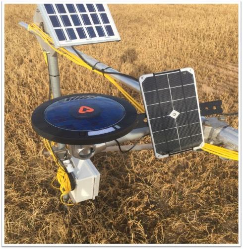
2 Overview Physical and Biological Observations Precipitation Air temperature, humidity, pressure Shortwave (SW) radiation (down & upwelling) Longwave (LW) radiation (down & upwelling) Seven-band spectrometer (up and down) Band 1: nm Band 2: nm Band 3: nm Band 4: nm Band 5: nm Band 6: nm Band 7: nm Photosynthetically active radiation (PAR) Contextual and Health Observations GPS coordinates Acoustic sonogram (sound classification) Tilt, compass, acceleration Voltage, Charge RSSI Derived data (examples) Net radiation (Rn) from SW and LW radiometers ETo from radiometers and static air properties ETc from ETo and canopy cover Leaf temperature from upwelling longwave Surface wetness from leaf temperature Disease risk from leaf wetness and temperature Frost risk from net longwave balance Canopy cover and biomass from spectrometer* Growth rate from change in canopy cover* Canopy nitrogen content from spectrometer* Light use efficiency from spectrometer* Flowering and pollination from spectrometer* Photosynthesis (A) from PAR, fapar, and LUE* * benefits from variety-specific calibration Advantages of the Arable Mark versus a conventional weather station: Integrated modem, power, and mounting dramatically reduces installation burden Measures not only conventional weather, but also drivers of crop performance (ET, A), as well as crop response to drivers (growth, reproduction, stress, nutrient and water status) Measures not only static air properties (temp, humidity, rain) but also surface fluxes (Rn, H, LE) Measures of agronomic importance (ET, disease risk, frost risk) Backfill and infill from weather model to enable complete seasonal view of heat accumulation versus a weather model: Enables bias correction for Point Forecasts of T, precip and crop metrics like ET and disease versus a drone: Continuous measurements enable integration in time (e.g. heat accumulation) and ephemeral events (e.g. frost, heat spike, rain event) that are essential for forecasts versus a satellite: Continuous and high fidelity spectroscopy unlocks value of infrequent and error-prone imagery
3 Accuracy Measurement Setting UNL Ameriflux Site, Mead NE, June 2016, 5m above a field of soybeans (Glycine max) Rutgers University Photochemical Assessment Monitoring Site (a) at New Brunswick, NJ in August, 2016 Reference Instruments Vaisala HMP50 Temperature and Relative Humidity Sensor (Vaisala Instruments, Vantaa, Finland) RM Young 61302V (RM Young, Traverse City, MI) R 2 = 0.99 R 2 = 0.95 R 2 = 0.99 Measurement Mark Sensor Accuracy Mark to Reference Relative Accuracy Reference Manufacturer Accuracy Air Temperature ± 0.75 C over the range -40 to 125 C 4% of measurement (mean relative error ± one σ) ± 1.5 C over the temperature range -40 C to 60 C Relative Humidity ± 3% RH over the range 0 to 100% 6% of measurement (mean relative error ± one σ) ± 3% RH over the range 0 to 90% RH and ± 5% over the range 90 to 95% RH Barometric Pressure ± 4 mbar over the pressure range 500 to 1100 mbar 0.1% of measurement (mean relative error ± one σ) 0.05% over analog pressure range (± one σ)
4 Accuracy Measurement Setting UNL Ameriflux Site, Mead NE, June 2016 Rutgers University Photochemical Assessment Monitoring Site (a) at New Brunswick, NJ in August, 2016 Reference Instruments Kipp and Zonen CM3, CNR4 Net Radiometer (Kipp and Zonen B.V., Delft, The Netherlands) LI-190 Quantum Sensor (LI-COR, Inc. Lincoln, NE) R 2 = 0.98 R 2 = 0.87 R 2 = 0.98 Measurement Mark to Reference Relative Accuracy Reference Manufacturer Accuracy Shortwave Energy Longwave Energy 4% at the daily total level of downwelling energy (mean error ± one σ) 4% at the daily total level of upwelling energy (mean error ± one σ) 5% at the daily total level (95% confidence interval) < 10% at the daily total level (95% confidence interval) Net Radiation 10% at the daily total level (mean error ± one σ) Not stated PAR 6% at the daily total level (mean error ± one σ) ± 5% traceable to the U.S. National Institute of Standards and Technology
5 Accuracy Measurement Setting UNL Ameriflux Site, Mead NE, June 2016 Rutgers University Photochemical Assessment Monitoring Site (a) at New Brunswick, NJ in August, 2016 Reference Instruments B&W Tek i-trometer Portable Spectrometer (B&W Tek, Newark, DE) Instruments SA, Inc. Monochromator Spectrometer bands relative to solar spectrum Absorption kernels of spectrometer bands

6 Accuracy
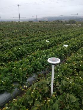
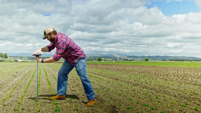
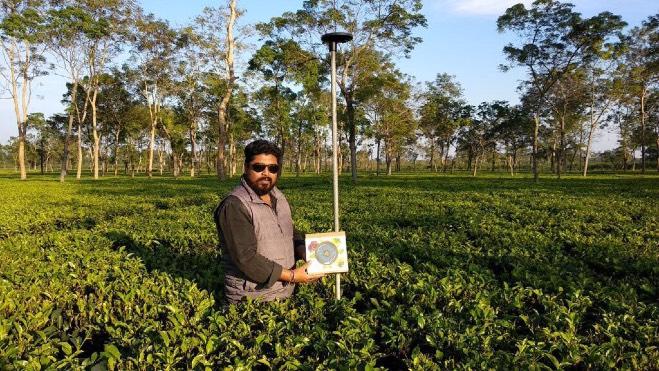

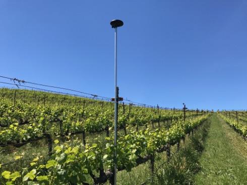
7 Applications: Mounting Strawberry Center Pivot Tea Celery Vineyard Orchard
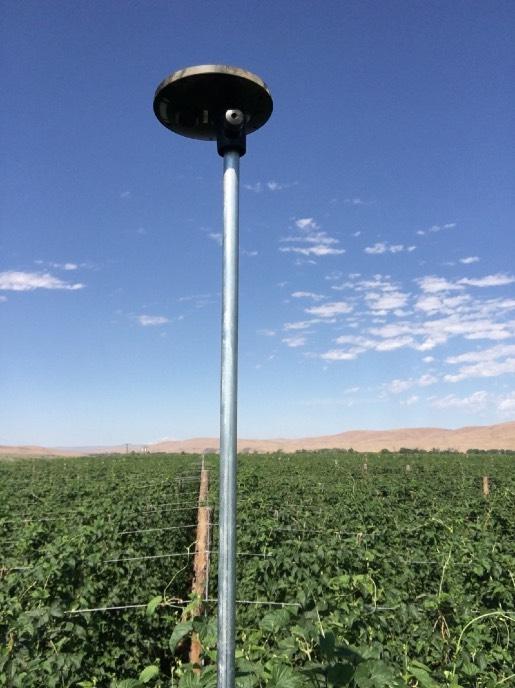
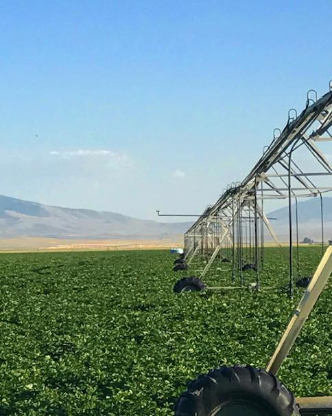
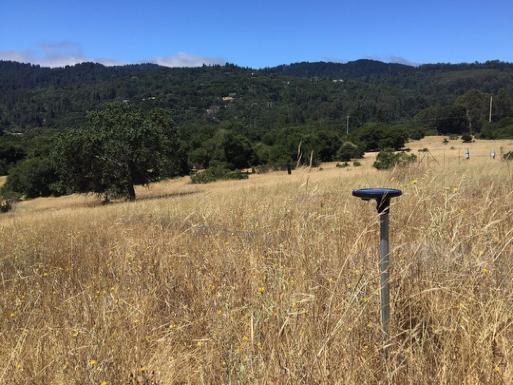
8 Applications: Mounting Hops Research Potatoes Rangeland
9 Applications: Water Cycle ETo, Kc, and ETc Measurement Setting UNL Mesonet (Brule N, Brule S), June-July 2017 R 2 = 0.72 MAE = 0.85 mm/day Reference Instruments Vaisala HMP50 RM Young 61302V Li-200 Pyranometer Water Potential Measurement Setting Various CA Vineyards Aug 2017 Reference Instruments PMS Model 1505D Pressure Bomb


10 Applications: Disease Liquid water and temperature sensitivity define many pathogens Downy Mildew Powdery Mildew Apr May Jun Jul Aug Sep Oct
11 Applications: Crop Monitoring and Prediction


12 Applications: Spatial Analysis 6/6/2017 Satellite 6/12/2017


13 Applications: Short term weather extremes Frost, Heat, Scald
Trevor Lee Director, Buildings. Grant Edwards PhD Department of Environment and Geography
 Weather Affects Building Performance Simulation v Monitoring real time solar and coincident weather data for building optimisation and energy management Trevor Lee Director, Buildings Grant Edwards PhD
Climate Change and Arizona s Rangelands: Management Challenges and Opportunities
 Climate Change and Arizona s Rangelands: Management Challenges and Opportunities Mike Crimmins Climate Science Extension Specialist Dept. of Soil, Water, & Env. Science & Arizona Cooperative Extension
Weather Station: WH_500_Series. Battery Voltage
 Battery Voltage 12.800 12.795 12.790 Voltage 12.785 12.780 12.775 12.770 Apr 2015 8 Wed 15 Wed 22 Wed 1 Fri Time Page 1 Date Batt Volt Min 4/1/2015 12.77 4/2/2015 12.78 4/3/2015 12.80 4/4/2015 12.79 4/5/2015
Variability of Reference Evapotranspiration Across Nebraska
 Know how. Know now. EC733 Variability of Reference Evapotranspiration Across Nebraska Suat Irmak, Extension Soil and Water Resources and Irrigation Specialist Kari E. Skaggs, Research Associate, Biological
2008 Growing Season. Niagara Region
 28 Growing Season Niagara Region Weather INnovations Staff November 14, 28 Overview The start of the 28 growing season looked promising. After an extremely dry 27 growing season, soil moisture levels had
UWM Field Station meteorological data
 University of Wisconsin Milwaukee UWM Digital Commons Field Station Bulletins UWM Field Station Spring 992 UWM Field Station meteorological data James W. Popp University of Wisconsin - Milwaukee Follow
ZUMWALT WEATHER AND CLIMATE ANNUAL REPORT ( )
") ZUMWALT WEATHER AND CLIMATE ANNUAL REPORT (26-29) FINAL DRAFT (9 AUGUST 21) J.D. HANSEN 1, R.V. TAYLOR 2, AND V.S. JANSEN 3 INTRODUCTION The Zumwalt Prairie in northeastern Oregon is a unique grassland
ZUMWALT WEATHER AND CLIMATE ANNUAL REPORT (26-29) FINAL DRAFT (9 AUGUST 21) J.D. HANSEN 1, R.V. TAYLOR 2, AND V.S. JANSEN 3 INTRODUCTION The Zumwalt Prairie in northeastern Oregon is a unique grassland
Microclimate. Climate & scale. Measuring a Microclimate Microclimates VARY. Microclimate factors. Aboveground environment.
 Microenvironments Microenvironments Aboveground environment Belowground environment Edaphic factors soil environment Macroclimate Climate & scale Mesoclimate factors Temperature s VARY I. In Time Long
Development of Innovative Technology to Provide Low-Cost Surface Atmospheric Observations in Data-sparse Regions
 Development of Innovative Technology to Provide Low-Cost Surface Atmospheric Observations in Data-sparse Regions Paul Kucera and Martin Steinson University Corporation for Atmospheric Research/COMET 3D-Printed
Station Maintenance and Calibration Report ABRAHAM LINCOLN BIRTHPLACE NATIONAL HISTORIC SITE March 13, 2007
 Station Maintenance and Calibration Report ABRAHAM LINCOLN BIRTHPLACE NATIONAL HISTORIC SITE March 13, 2007 National Park Service Gaseous Pollutant Monitoring Program Prepared by Air Resource Specialists,
INSTALLATION OF PORTABLE O3 MONITORING STATION NATIONAL PARK SERVICE AMBIENT AIR QUALITY AND METEOROLOGY MONITORING NETWORK
 INSTALLATION OF PORTABLE O3 MONITORING STATION TIOL PARK SERVICE AMBIENT AIR QUALITY AND METEOROLOGY MONITORING NETWORK ASSATEAGUE ISLAND TIOL SEASHORE APRIL 24, 2006 prepared for John Ray TIOL PARK SERVICE
Memo. I. Executive Summary. II. ALERT Data Source. III. General System-Wide Reporting Summary. Date: January 26, 2009 To: From: Subject:
 Memo Date: January 26, 2009 To: From: Subject: Kevin Stewart Markus Ritsch 2010 Annual Legacy ALERT Data Analysis Summary Report I. Executive Summary The Urban Drainage and Flood Control District (District)
SU solar resource measurement station: Sonbesie metadata
 SU solar resource measurement station: Sonbesie metadata Date: 30 July 2013 Introduction A solar resource measurement station, known as Sonbesie, has been installed at Stellenbosch University. The system
Plant Water Stress Frequency and Periodicity in Western North Dakota
 Plant Water Stress Frequency and Periodicity in Western North Dakota Llewellyn L. Manske PhD, Sheri Schneider, John A. Urban, and Jeffery J. Kubik Report DREC 10-1077 Range Research Program Staff North
A FIRST INVESTIGATION OF TEMPORAL ALBEDO DEVELOPMENT OVER A MAIZE PLOT
 1 A FIRST INVESTIGATION OF TEMPORAL ALBEDO DEVELOPMENT OVER A MAIZE PLOT Robert Beyer May 1, 2007 INTRODUCTION Albedo, also known as shortwave reflectivity, is defined as the ratio of incoming radiation
Sensing Strategies and Software Tools to Help Farmers Adapt to a Changing Climate
 Sensing Strategies and Software Tools to Help Farmers Adapt to a Changing Climate John D. Lea-Cox Department of Plant Science and Landscape Architecture University of Maryland, College Park, MD USA JLC@umd.edu
Comparative analysis of data collected by installed automated meteorological stations and manual data in Central Asia.
 Comparative analysis of data collected by installed automated meteorological stations and manual data in Central Asia. Merkushkin Aleksandr Uzhydromet 71 K. Makhsumov str., 100052 Tashkent, Uzbekistan
Assimilation of satellite derived soil moisture for weather forecasting
 Assimilation of satellite derived soil moisture for weather forecasting www.cawcr.gov.au Imtiaz Dharssi and Peter Steinle February 2011 SMOS/SMAP workshop, Monash University Summary In preparation of the
Eric. W. Harmsen 1, John Mecikalski 2, Vanessa Acaron 3 and Jayson Maldonado 3
 Estimating Ground-Level Solar Radiation and Evapotranspiration In Puerto Rico Using Satellite Remote Sensing Eric. W. Harmsen 1, John Mecikalski 2, Vanessa Acaron 3 and Jayson Maldonado 3 1 Department
Near-surface weather prediction and surface data assimilation: challenges, development, and potential data needs
 Near-surface weather prediction and surface data assimilation: challenges, development, and potential data needs Zhaoxia Pu Department of Atmospheric Sciences University of Utah, Salt Lake City, Utah,
2016 Meteorology Summary
 2016 Meteorology Summary New Jersey Department of Environmental Protection AIR POLLUTION AND METEOROLOGY Meteorology plays an important role in the distribution of pollution throughout the troposphere,
A sensitivity and uncertainty analysis. Ministry of the Walloon Region Agricultural Research Centre
 Development of an agrometeorological model integrating leaf wetness duration estimation and weather radar data to assess the risk of head blight infection in wheat A sensitivity and uncertainty analysis
Drought Characterization. Examination of Extreme Precipitation Events
 Drought Characterization Examination of Extreme Precipitation Events Extreme Precipitation Events During the Drought For the drought years (1999-2005) daily precipitation data was analyzed to find extreme
Many of remote sensing techniques are generic in nature and may be applied to a variety of vegetated landscapes, including
 Remote Sensing of Vegetation Many of remote sensing techniques are generic in nature and may be applied to a variety of vegetated landscapes, including 1. Agriculture 2. Forest 3. Rangeland 4. Wetland,
Relationship between light use efficiency and photochemical reflectance index in soybean leaves as affected by soil water content
 International Journal of Remote Sensing Vol. 27, No. 22, 20 November 2006, 5109 5114 Relationship between light use efficiency and photochemical reflectance index in soybean leaves as affected by soil
The Climate of Grady County
 The Climate of Grady County Grady County is part of the Central Great Plains, encompassing some of the best agricultural land in Oklahoma. Average annual precipitation ranges from about 33 inches in northern
Potential indicators of habitat and water quality in the lower Columbia River
 Potential indicators of habitat and water quality in the lower Columbia River Joe Needoba, Ph.D. Associate Professor OHSU-PSU School of Public Health How did the Blob influence the Columbia River estuary?
Non-Acoustical Inputs
 CHAPTER 18 Non-Acoustical Inputs This chapter discusses the use of external transducers and devices to provide non-acoustical data to the Model 831. Included are the following: 831-INT 831-INT Interface
Mapping Evapotranspiration and Drought at Local to Continental Scales Using Thermal Remote Sensing
 Mapping Evapotranspiration and Drought at Local to Continental Scales Using Thermal Remote Sensing M.C. Anderson, W.P. Kustas USDA-ARS, Hydrology and Remote Sensing Laboratory J.M Norman University of
Remote Sensing Applications for Land/Atmosphere: Earth Radiation Balance
 Remote Sensing Applications for Land/Atmosphere: Earth Radiation Balance - Introduction - Deriving surface energy balance fluxes from net radiation measurements - Estimation of surface net radiation from
Local Precipitation Variability
 Local Precipitation Variability Precipitation from one storm can vary from neighborhood to neighborhood. What falls in your yard may not fall in the next. The next time it rains see how the precipitation
Jackson County 2013 Weather Data
 Jackson County 2013 Weather Data 61 Years of Weather Data Recorded at the UF/IFAS Marianna North Florida Research and Education Center Doug Mayo Jackson County Extension Director 1952-2008 Rainfall Data
Supplementary appendix
 Supplementary appendix This appendix formed part of the original submission and has been peer reviewed. We post it as supplied by the authors. Supplement to: Lowe R, Stewart-Ibarra AM, Petrova D, et al.
The Climate of Seminole County
 The Climate of Seminole County Seminole County is part of the Crosstimbers. This region is a transition region from the Central Great Plains to the more irregular terrain of southeastern Oklahoma. Average
Single-Column Modeling, General Circulation Model Parameterizations, and Atmospheric Radiation Measurement Data
 Single-Column ing, General Circulation Parameterizations, and Atmospheric Radiation Measurement Data S. F. Iacobellis, D. E. Lane and R. C. J. Somerville Scripps Institution of Oceanography University
Australian Considerations for the Year of Polar Prediction
 Australian Considerations for the Year of Polar Prediction 2017-2018 Mawson (1954) Davis (1957) Macquarie Is. (1948) Casey (1969) Photos by Christopher Wilkins (AAD) Observations Surface Observations upper
Using NEWA Resources in a Vineyard IPM Strategy. Tim Weigle and Juliet Carroll NYS IPM Program, Cornell Cooperative Extension
 Using NEWA Resources in a Vineyard IPM Strategy Tim Weigle and Juliet Carroll NYS IPM Program, Cornell Cooperative Extension Historically, control practices for vineyard pests in the eastern United States
The Albedo of Junipers
 The Albedo of Junipers Measured in Summer 29 at the Niederhorn, Switzerland Werner Eugster1, and Brigitta Ammann2 1 ETH Zu rich, Institute of Plant Sciences, CH 892 Zu rich, Switzerland 2 University of
for JMA/WMO Training Workshop on CALIBRATION AND MAINTENANCE OF METEOROLOGICAL INSTRUMENTS
 for JMA/WMO Training Workshop on CALIBRATION AND MAINTENANCE OF METEOROLOGICAL INSTRUMENTS in RA II (ASIA) 0. Overview of JMA 3 4 1. Surface observation station 5-8 2. Instruments in operational use 9-14
The Climate of Marshall County
 The Climate of Marshall County Marshall County is part of the Crosstimbers. This region is a transition region from the Central Great Plains to the more irregular terrain of southeastern Oklahoma. Average
Flux Tower Data Quality Analysis in the North American Monsoon Region
 Flux Tower Data Quality Analysis in the North American Monsoon Region 1. Motivation The area of focus in this study is mainly Arizona, due to data richness and availability. Monsoon rains in Arizona usually
The Climate of Bryan County
 The Climate of Bryan County Bryan County is part of the Crosstimbers throughout most of the county. The extreme eastern portions of Bryan County are part of the Cypress Swamp and Forest. Average annual
BMKG Research on Air sea interaction modeling for YMC
 BMKG Research on Air sea interaction modeling for YMC Prof. Edvin Aldrian Director for Research and Development - BMKG First Scientific and Planning Workshop on Year of Maritime Continent, Singapore 27-3
APPENDIX 3.6-A Support Information for Newcastle, Wyoming Meteorological Monitoring Site
 APPENDIX 3.6-A Support Information for Newcastle, Wyoming Meteorological Monitoring Site September 2012 3.6-A-i Appendix 3.6-A This page intentionally left blank September 2012 Appendix 3.6-A APPENDIX
pest management decisions
 Using Enviroweather to assist pest management decisions Emily Pochubay 2014 Integrated Pest Management Academy February 19, 2014 Okemos, MI www.enviroweather.msu.edu Enviro-weather An online resource that
Eric Snodgrass Co-Founder and Senior Atmospheric Scientist of Agrible, Inc Director of Undergraduate Studies Department of Atmospheric Sciences
 Eric Snodgrass Co-Founder and Senior Atmospheric Scientist of Agrible, Inc Director of Undergraduate Studies Department of Atmospheric Sciences University Of Illinois Urbana-Champaign snodgrss@illinois.edu
HAIDA GWAII CLIMATE ASSESSMENT 2010 Special Report for MIEDS Franc Pridoehl
 HAIDA GWAII CLIMATE ASSESSMENT 2010 Special Report for MIEDS Franc Pridoehl INTRODUCTION Climatic conditions have varied considerably on Haida Gwaii over the past centuries and millennia (Hebda 2007).
Champaign-Urbana 2000 Annual Weather Summary
 Champaign-Urbana 2000 Annual Weather Summary ILLINOIS STATE WATER SURVEY 2204 Griffith Dr. Champaign, IL 61820 wxobsrvr@sws.uiuc.edu Maria Peters, Weather Observer January: January started on a mild note,
Land Data Assimilation at NCEP NLDAS Project Overview, ECMWF HEPEX 2004
 Dag.Lohmann@noaa.gov, Land Data Assimilation at NCEP NLDAS Project Overview, ECMWF HEPEX 2004 Land Data Assimilation at NCEP: Strategic Lessons Learned from the North American Land Data Assimilation System
Joint Polar Satellite System. 3 rd Post-EPS User Consultation Workshop Mike Haas
 3 rd Post-EPS User Consultation Workshop Mike Haas Overview Introduction - Policy Drivers - Management System Description - Space Segment - Ground Segment Partnerships Status Benefits 2 Introduction (Policy
Application of the Integrated Aerobiology Modeling System to Soybean Rust Forecasting in 2006
 Application of the Integrated Aerobiology Modeling System to Soybean Rust Forecasting in 2006 Scott A. Isard Penn State University & Joseph M. Russo ZedX Inc. Integrated Aerobiology Modeling System (IAMS)
Jackson County 2018 Weather Data 67 Years of Weather Data Recorded at the UF/IFAS Marianna North Florida Research and Education Center
 Jackson County 2018 Weather Data 67 Years of Weather Data Recorded at the UF/IFAS Marianna North Florida Research and Education Center Doug Mayo Jackson County Extension Director 1952-2008 Rainfall Data
The Climate of Payne County
 The Climate of Payne County Payne County is part of the Central Great Plains in the west, encompassing some of the best agricultural land in Oklahoma. Payne County is also part of the Crosstimbers in the
BSRN STATION DESCRIPTION
 Description page 1-7 valid until 2014-12-31, for the description from 2015-01-01 on see page 8-14 BSRN STATION STATION MANAGER Atmospheric Environment Division, Japan Meteorological Agency (JMA) Address:
Vermont Soil Climate Analysis Network (SCAN) sites at Lye Brook and Mount Mansfield
 sites at Lye Brook and Mount Mansfield") Vermont Soil Climate Analysis Network (SCAN) sites at Lye Brook and Mount Mansfield 13 Years of Soil Temperature and Soil Moisture Data Collection September 2000 September 2013 Soil Climate Analysis Network
Vermont Soil Climate Analysis Network (SCAN) sites at Lye Brook and Mount Mansfield 13 Years of Soil Temperature and Soil Moisture Data Collection September 2000 September 2013 Soil Climate Analysis Network
The Climate of Murray County
 The Climate of Murray County Murray County is part of the Crosstimbers. This region is a transition between prairies and the mountains of southeastern Oklahoma. Average annual precipitation ranges from
September 2018 Weather Summary West Central Research and Outreach Center Morris, MN
 September 2018 Weather Summary The mean temperature for September was 60.6 F, which is 1.5 F above the average of 59.1 F (1886-2017). The high temperature for the month was 94 F on September 16 th. The
Chiang Rai Province CC Threat overview AAS1109 Mekong ARCC
 Chiang Rai Province CC Threat overview AAS1109 Mekong ARCC This threat overview relies on projections of future climate change in the Mekong Basin for the period 2045-2069 compared to a baseline of 1980-2005.
5.6. Barrow, Alaska, USA
 SECTION 5: QUALITY CONTROL SUMMARY 5.6. Barrow, Alaska, USA The Barrow installation is located on Alaska s North Slope at the edge of the Arctic Ocean in the city of Barrow. The instrument is located in
The Nebraska Mesonet!"#$%"&'%()'*+,&-./#"'*"&'$"$.&0)+!"$1)12+'$&"-3&"''10+"$.&4#15.''1# 6789:;8<=>
'*+,&-./#'*&'$$.&0)+!$1)12+'$&-3&''10+$.&4#15.''1# 6789:;8<=>") The Nebraska Mesonet!"#$%"&'%()'*+,&-./#"'*"&'$"$.&0)+!"$1)12+'$&"-3&"''10+"$.&4#15.''1# 6789:;8 The Nebraska State Climate Office!"#$%&!'%()& MISSION Deliver science-based weather and climate information
The Nebraska Mesonet!"#$%"&'%()'*+,&-./#"'*"&'$"$.&0)+!"$1)12+'$&"-3&"''10+"$.&4#15.''1# 6789:;8 The Nebraska State Climate Office!"#$%&!'%()& MISSION Deliver science-based weather and climate information
Country Presentation-Nepal
 Country Presentation-Nepal Mt.Everest, Shiva Pd. Nepal, DHM South Asia Drought Monitor Workshop Dhaka Bangladesh 2 th April 215 Overview Brief Climatology Climate activities- DHM PPCR (Pilot Program for
2003 Water Year Wrap-Up and Look Ahead
 2003 Water Year Wrap-Up and Look Ahead Nolan Doesken Colorado Climate Center Prepared by Odie Bliss http://ccc.atmos.colostate.edu Colorado Average Annual Precipitation Map South Platte Average Precipitation
Projeto Temático FAPESP 2013/ Climate Ecosystems Atmospheric Composition
 Projeto Temático FAPESP 2013/05014-0 Climate Ecosystems Atmospheric Composition GoAmazon2014/15 Experiment Manaus is a city of 2 million people surrounded by just forest in a radius of 1.500 Km. UNIQUE
Volume XIV, Number 1 January 6, 2014
 Research & Extension for the Potato Industry of Idaho, Oregon, & Washington Andrew Jensen, Editor. ajensen@potatoes.com; 208-939-9965 www.nwpotatoresearch.com Volume XIV, Number 1 January 6, 2014 Accuracy
GRUAN Station Report for Ny-Ålesund
 WMO/IOC/UNEP/ICSU GLOBAL CLIMATE OBSERVING SYSTEM (GCOS) 8th GRUAN Implementation- Coordination Meeting (ICM-8) Boulder, USA 25 April 29 April 2016 Doc. 7.11 (05.IV.2016) Session 7 GRUAN Station Report
Champaign-Urbana 2001 Annual Weather Summary
 Champaign-Urbana 2001 Annual Weather Summary ILLINOIS STATE WATER SURVEY 2204 Griffith Dr. Champaign, IL 61820 wxobsrvr@sws.uiuc.edu Maria Peters, Weather Observer January: After a cold and snowy December,
PREDICTING THE ONSET AND SEVERITY OF POTATO LATE BLIGHT IN OREGON
 PREDICTING THE ONSET AND SEVERITY OF POTATO LATE BLIGHT IN OREGON Clinton C. Shock, Cedric A. Shock, and Lamont D. Saunders Malheur Experiment Station Lynn Jensen Malheur County Extension Service Oregon
November 2018 Weather Summary West Central Research and Outreach Center Morris, MN
 November 2018 Weather Summary Lower than normal temperatures occurred for the second month. The mean temperature for November was 22.7 F, which is 7.2 F below the average of 29.9 F (1886-2017). This November
Inter-linkage case study in Pakistan
 7 th GEOSS Asia Pacific Symposium GEOSS AWCI Parallel Session: 26-28 May, 2014, Tokyo, Japan Inter-linkage case study in Pakistan Snow and glaciermelt runoff modeling in Upper Indus Basin of Pakistan Maheswor
Monthly Long Range Weather Commentary Issued: APRIL 25, 2016 Steven A. Root, CCM, Chief Analytics Officer, Sr. VP, sales
 Monthly Long Range Weather Commentary Issued: APRIL 25, 2016 Steven A. Root, CCM, Chief Analytics Officer, Sr. VP, sales sroot@weatherbank.com MARCH 2016 Climate Highlights The Month in Review The March
AgWeatherNet A Tool for Making Decisions Based on Weather
 AgWeatherNet A Tool for Making Decisions Based on Weather Gerrit Hoogenboom Director, AgWeatherNet & Professor of Agrometeorology Washington State University Prosser, Washington November 14, 2013 Washington
Terminal Ceiling & Visibility PDT
 Terminal Ceiling & Visibility PDT AWRP Program Management Review 19 November 2002 Dave Clark PMR_Nov_02-1 Terminal C&V Project Areas SFO Marine Stratus Forecast System - 2002 Activities - Continued development
Road Weather: The Science Behind What You Know
 The Weather Road Weather: The Science Behind What You Know Jon Tarleton Global Roads Marketing Manager Meteorologist Jon.tarleton@vaisala.com Page 2 / date / name / Internal use / Vaisala Weather and Our
Water vapour above Switzerland over the last 12 years
 Water vapour above Switzerland over the last 12 years June Morland*, Martine Collaud**, Klemens Hocke*, Pierre Jeannet**, Christian Mätzler* *Institute of Applied Physics, University of Bern **MeteoSwiss
School on Modelling Tools and Capacity Building in Climate and Public Health April Remote Sensing
 2453-5 School on Modelling Tools and Capacity Building in Climate and Public Health 15-26 April 2013 Remote Sensing CECCATO Pietro International Research Institute for Climate and Society, IRI The Earth
US Drought Status. Droughts 1/17/2013. Percent land area affected by Drought across US ( ) Dev Niyogi Associate Professor Dept of Agronomy
 Dev Niyogi Associate Professor Dept of Agronomy") Droughts US Drought Status Dev Niyogi Associate Professor Dept of Agronomy Deptof Earth Atmospheric Planetary Sciences Indiana State Climatologist Purdue University LANDSURFACE.ORG iclimate.org climate@purdue.edu
Droughts US Drought Status Dev Niyogi Associate Professor Dept of Agronomy Deptof Earth Atmospheric Planetary Sciences Indiana State Climatologist Purdue University LANDSURFACE.ORG iclimate.org climate@purdue.edu
The Climate of Pontotoc County
 The Climate of Pontotoc County Pontotoc County is part of the Crosstimbers. This region is a transition region from the Central Great Plains to the more irregular terrain of southeast Oklahoma. Average
Climate Variability and Malaria over the Sahel Country of Senegal
 Climate Variability and Malaria over the Sahel Country of Senegal Ibrahima DIOUF CPC International Desks NOAA Center for Weather and Climate Prediction 5830 University Research Court, College Park, Maryland
Title: The Importance of Daily Light Integral (DLI) for Indoor Cannabis Cultivation
 for Indoor Cannabis Cultivation") Title: The Importance of Daily Light Integral (DLI) for Indoor Cannabis Cultivation Haley Bishoff - Smart Grow Systems Research Team 1. Bachelors of Science in Nutrition and Dietetics, Oregon State University
Title: The Importance of Daily Light Integral (DLI) for Indoor Cannabis Cultivation Haley Bishoff - Smart Grow Systems Research Team 1. Bachelors of Science in Nutrition and Dietetics, Oregon State University
The Climate of Haskell County
 The Climate of Haskell County Haskell County is part of the Hardwood Forest. The Hardwood Forest is characterized by its irregular landscape and the largest lake in Oklahoma, Lake Eufaula. Average annual
Promoting Rainwater Harvesting in Caribbean Small Island Developing States Water Availability Mapping for Grenada Preliminary findings
 Promoting Rainwater Harvesting in Caribbean Small Island Developing States Water Availability Mapping for Grenada Preliminary findings National Workshop Pilot Project funded by The United Nations Environment
Communicating Climate Change Consequences for Land Use
 Communicating Climate Change Consequences for Land Use Site: Prabost, Skye. Event: Kyle of Lochalsh, 28 th February 28 Further information: http://www.macaulay.ac.uk/ladss/comm_cc_consequences.html Who
Comparison of measured and modelled wetness duration as inputs to a grape disease model
 405 Comparison of measured and modelled wetness duration as inputs to a grape disease model W.R. Henshall, G.N. Hill and R.M. Beresford The New Zealand Institute for Plant & Food Research Ltd, Private
Appendix C. AMEC Evaluation of Zuni PPIW. Appendix C. Page C-1 of 34
 AMEC s Independent Estimate of PPIW Crop Water Use Using the ASCE Standardized Reference Evapotranspiration via Gridded Meteorological Data, and Estimation of Crop Coefficients, and Net Annual Diversions
EXAMINATION OF MODELS FOR THE PREDICTION OF THE ONSET AND SEVERITY OF POTATO LATE BLIGHT IN OREGON
 EXAMINATION OF MODELS FOR THE PREDICTION OF THE ONSET AND SEVERITY OF POTATO LATE BLIGHT IN OREGON Clinton C. Shock, Cedric A. Shock, Lamont D. Saunders, and Brad Coen Malheur Experiment Station Lynn Jensen
Prince Edward County Appellation 2015 Growing Season Summary
 Overview Prince Edward County Appellation 215 Growing Season Summary The 215 growing season in the Prince Edward County appellation ended with above normal heat units. Daytime temperatures typically averaged
The Climate of Kiowa County
 The Climate of Kiowa County Kiowa County is part of the Central Great Plains, encompassing some of the best agricultural land in Oklahoma. Average annual precipitation ranges from about 24 inches in northwestern
Plant Growth & Development. Growth Processes Photosynthesis. Plant Growth & Development
 Plant Growth & Development Growth Processes Growth Requirements Types of Growth & Development Factors Growth Processes Photosynthesis Creating carbohydrates (stored energy) from CO 2 + water + sunlight
Central Ohio Air Quality End of Season Report. 111 Liberty Street, Suite 100 Columbus, OH Mid-Ohio Regional Planning Commission
 217 218 Central Ohio Air Quality End of Season Report 111 Liberty Street, Suite 1 9189-2834 1 Highest AQI Days 122 Nov. 217 Oct. 218 July 13 Columbus- Maple Canyon Dr. 11 July 14 London 11 May 25 New Albany
Interview with Dr. Jaya Singh. 1. How critical is weather monitoring in a solar power plant and what are all the parameters to be monitored?
 Interview with Dr. Jaya Singh Dr. Jaya Singh is an entrepreneur and scientist with experience in a range of industries including biotech, environmental sciences, and agriculture. She currently drives strategy
Impact on Agriculture
 Weather Variability and the Impact on Agriculture InfoAg 2017 Copyright 2017, awhere. All Rights Reserved The Problem: The Earth s Atmosphere is a Heat Engine In transition 1 C warming of atmosphere Triples
Characteristics of the night and day time atmospheric boundary layer at Dome C, Antarctica
 Characteristics of the night and day time atmospheric boundary layer at Dome C, Antarctica S. Argentini, I. Pietroni,G. Mastrantonio, A. Viola, S. Zilitinchevich ISAC-CNR Via del Fosso del Cavaliere 100,
Meteorological Service
 Meteorological Service The Meteorological Service in Oman was established in 1973. Oman joined ICAO in 1973 Oman joined WMO in 1975. Meteorological Service is under the framework of the Directorate General
P1.34 MULTISEASONALVALIDATION OF GOES-BASED INSOLATION ESTIMATES. Jason A. Otkin*, Martha C. Anderson*, and John R. Mecikalski #
 P1.34 MULTISEASONALVALIDATION OF GOES-BASED INSOLATION ESTIMATES Jason A. Otkin*, Martha C. Anderson*, and John R. Mecikalski # *Cooperative Institute for Meteorological Satellite Studies, University of
Comparing the Relationships Between Heat Stress Indices and Mortality in North Carolina
 Comparing the Relationships Between Heat Stress Indices and Mortality in North Carolina Jordan Clark PhD Student CISA Research Assistant Department of Geography UNC-Chapel Hill 10/30/2018 Overview Background
WMO number: Internal Station number: same as WMO number, historic AWOS documents refer to the station as A19. Current Station Location
 Basic Climatological Station Metadata Current Status (draft in word by gjh, 28.01.09, DGCA to complete all areas highlighted in yellow color) Metadata compiled: 2009 Station: Kuwait City WMO number: 40581
Soil Moisture Prediction and Assimilation
 Soil Moisture Prediction and Assimilation Analysis and Prediction in Agricultural Landscapes Saskatoon, June 19-20, 2007 STEPHANE BELAIR Meteorological Research Division Prediction and Assimilation Atmospheric
Yield Responses to Supplemental Lighting
 Yield Responses to Supplemental Lighting Solar radiation Sunlight s full spectrum ranges from 3 to 3 nm Heat Light for plant growth and development Three dimensions Celina Gómez, PhD Environmental Horticulture
APPENDIX G-7 METEROLOGICAL DATA
 APPENDIX G-7 METEROLOGICAL DATA METEOROLOGICAL DATA FOR AIR AND NOISE SAMPLING DAYS AT MMR Monthly Normals and Extremes for Honolulu International Airport Table G7-1 MMR RAWS Station Hourly Data Tables
Radiative Climatology of the North Slope of Alaska and the Adjacent Arctic Ocean
 Radiative Climatology of the North Slope of Alaska and the Adjacent Arctic Ocean C. Marty, R. Storvold, and X. Xiong Geophysical Institute University of Alaska Fairbanks, Alaska K. H. Stamnes Stevens Institute