BSRN STATION DESCRIPTION
|
|
|
- Christina Harrison
- 6 years ago
- Views:
Transcription
1 Description page 1-7 valid until , for the description from on see page 8-14 BSRN STATION STATION MANAGER Atmospheric Environment Division, Japan Meteorological Agency (JMA) Address: Otemachi, Chiyoda-ku, Tokyo , Japan Tel : (ext. 4136) FAX : rrc-jma@met.kishou.go.jp STATION LOCATION Latitude : ( deg.) N Longitude: ( deg.) E Elevation : 2.5 m (MSL) Local Time: GMT + 09 Topography Type: 1 (flat, urban) Surface Type : 12 (asphalt) Address : Ohori, Chuo-ku, Fukuoka-shi, Fukuoka , Japan PHOTOMAP OF SURROUNDING 15 KM RADIUS 15km BSRN Fukuoka (c)2009 Google Image (c)2009 TerraMetrics 1


2009 Digital, GeoEye, Digital Earth Technology 1 A tower at 200 meters distance in ESE direction.")
2 BSRN SITE SITE Fukuoka district meteorological observatory Fukuoka District Meteorological Observatory Instruments are installed at the rooftop of Fukuoka district meteorological observatory. CLIMATE Köppen climate classification Cfa (Humid subtropical climate) ( ) (mm) annual mean temp.: annual rainfall: mm DESCRIPTIVE MAP OF SURROUNDING 1 KM RADIUS 1km 4 BSRN Fukuoka (c)2009 Google Image (c)2009 Digital, GeoEye, Digital Earth Technology 1 A tower at 200 meters distance in ESE direction. 2 A building at 100 meters distance in SE direction. 3 A building at 200 meters distance in SW direction. 4 A building at 200 meters distance in W direction. 2
 Kipp & Zonen CHP1")
 Kipp & Zonen CMP22")

 Kipp & Zonen CHP1 Pyrheliometer")


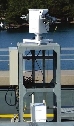
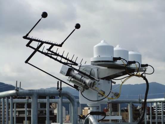
3 BSRN SITE INSTRUMENT INSTRUMENT LOCATION MAP 1 First Tracker (PREDE ASTX-220) Kipp & Zonen CHP1 Pyrheliometer Kipp & Zonen CMP21 Pyranometer (for Global Solar Radiation) Kipp & Zonen CMP22 Pyranometer (for Diffuse Solar Radiation) Kipp & Zonen CGR4 Pyrgeometer Height from ground level: 22.0 m Sampling frequency :1 Hz 2 Second Tracker (PREDE ASTX-220) Kipp & Zonen CHP1 Pyrheliometer HORIZON MAP OF CENTRAL INSTRUMENT Height from ground level: 15.9 m Sampling frequency :1 Hz VIEW5 N W S E VIEW2 VIEW4 OF METEOROLOGICAL INSTRUMENTS 1 2 Shaded Global Shaded Longwave Direct Solar Radiation Global Radiation Direct Solar Radiation For reduction of obstruction effect, the second tracker is installed. ( P7 COMMENT ON THE SITE ) 3


4 BSRN STATION VIEWS VIEW1 建物 1 鉄塔 Eastern View Azimuth 90 degrees Inclination ~5 degrees VIEW2 Tower and Building View 1Tower 2Building 1Tower Azimuth 115 degrees Inclination 8 degrees 2Building Ai Azimuth th140d degrees Inclination 5 degrees 4


5 BSRN STATION VIEWS VIEW3 Southern View Azimuth 180 degrees Inclination ~5 degrees VIEW4 3Building Building View Azimuth 235 degrees Inclination 10 degrees 5


6 BSRN STATION VIEWS VIEW5 5Meteorological Radar Tower 6Propeller Vane 4Building Western View 4Building Azimuth 260 degrees Inclination 10 degrees 5Tower Azimuth 270 degrees Inclination 24 degrees 6Propeller Vane Azimuth 285 degrees Inclination 10 degrees VIEW6 Northern View Azimuth 360 degrees Inclination ~5 degrees 6


7 COMMENT ON THE SITE Additional observation programs: (a) WMO WWW programme: upper-air observation o surface observations (i.e. surface air temp., air pressure, humidity, wind, cloud amount, etc.) Calibration: All radiometers are calibrated every 5 years. Pyrheliometers and pyranometers are traceable to the WRR, and pyrgeometer is traceable to the World Infrared Standard Group (WISG). The trackers will be overhauled every 5 years by its manufacturer. Direct solar radiation measurements: Some obstructions in a westward direction disturb direct beam radiation before sunset in some seasons (see View 5). To minimize missing direct beam data, two pyrheliometers are installed on different trackers and observe direct beam in parallel. a) the first tracker b) the second tracker Azimuth (deg.) Azimuth (deg.) Figure: Horizontal view and solar trajectory (red line) at two pyrheliometers on different trackers. a) the first tracker and b) the second tracker. 7
 FAX : +81-3-3211-4640 E-mail : rrc-jma@met.kishou.go.jp STATION LOCATION Latitude : 33 34.9 ( 33.5822 deg.) N Longitude: 130 22.6 (130.3764 deg.) E Elevation : 2.")
8 Since : BSRN STATION STATION MANAGER Atmospheric Environment Division, Japan Meteorological Agency (JMA) Address: Otemachi, Chiyoda-ku, Tokyo , Japan Tel : (ext. 4136) FAX : rrc-jma@met.kishou.go.jp STATION LOCATION Latitude : ( deg.) N Longitude: ( deg.) E Elevation : 2.5 m (MSL) Local Time: GMT + 09 Topography Type: 1 (flat, urban) Surface Type : 12 (asphalt) Address : Ohori, Chuo-ku, Fukuoka-shi, Fukuoka , Japan PHOTOMAP OF SURROUNDING 15 KM RADIUS 15km BSRN Fukuoka (c)2009 Google Image (c)2009 TerraMetrics 1
 ( ) (mm) 40 400 annual mean temp.: 16.6 30 20 10 0-10 -20-30 -40 annual rainfall: 1632.")

9 BSRN SITE SITE Fukuoka district meteorological observatory Fukuoka District Meteorological Observatory Instruments are installed at the rooftop of Fukuoka district meteorological observatory. CLIMATE Köppen climate classification Cfa (Humid subtropical climate) ( ) (mm) annual mean temp.: annual rainfall: mm DESCRIPTIVE MAP OF SURROUNDING 1 KM RADIUS 1km 4 BSRN Fukuoka (c)2009 Google Image (c)2009 Digital, GeoEye, Digital Earth Technology 1 A tower at 200 meters distance in ESE direction. 2 A building at 100 meters distance in SE direction. 3 A building at 200 meters distance in SW direction. 4 A building at 200 meters distance in W direction. 2
10


11 BSRN STATION VIEWS VIEW1 建物 1 鉄塔 Eastern View Azimuth 90 degrees Inclination ~5 degrees VIEW2 Tower and Building View 1Tower 2Building 1Tower Azimuth 115 degrees Inclination 8 degrees 2Building Azimuth 140 degrees Inclination 5 degrees 4


12 BSRN STATION VIEWS VIEW3 Southern View Azimuth 180 degrees Inclination ~5 degrees VIEW4 3Building Building View Azimuth 235 degrees Inclination 10 degrees 5

13 BSRN STATION VIEWS 3Building VIEW5 4Building Western View 3Building Azimuth 235 degrees Inclination 10 degrees 4Building Azimuth 260 degrees Inclination 10 degrees VIEW6 Northern View Azimuth 360 degrees Inclination ~5 degrees 6
 Calibration: All radiometers are calibrated every 5 years. Pyrheliometers and pyranometers are traceable to the WRR, and pyrgeometer is traceable to the World Infrared Standard Group (WISG).")
.")
14 COMMENT ON THE SITE Additional observation programs: (a) WMO WWW programme: upper-air observation surface observations (i.e. surface air temp., air pressure, humidity, wind, cloud amount, etc.) Calibration: All radiometers are calibrated every 5 years. Pyrheliometers and pyranometers are traceable to the WRR, and pyrgeometer is traceable to the World Infrared Standard Group (WISG). The trackers will be overhauled every 5 years by its manufacturer. Direct solar radiation measurements: Some obstructions in a westward direction disturb direct beam radiation before sunset in some seasons (see View 5). To minimize missing direct beam data, two pyrheliometers are installed on different trackers and observe direct beam in parallel. a) the first tracker b) the second tracker Azimuth (deg.) Azimuth (deg.) Figure: Horizontal view and solar trajectory (red line) at two pyrheliometers on different trackers. a) the first tracker and b) the second tracker. 7
Practicaluseof standardmeteorolo gicalinstruments indomesticmeteorolo gical observationnetworks
 Practicaluseof standardmeteorolo gicalinstruments indomesticmeteorolo gical observationnetworks Satoshi HAGIYA Meteorolo gicalinst rumentcenter WMO/RegionalInst rumentcentre (RIC) Tsukuba JapanMeteorologicalAgency(JMA)
Recent Improvement of Integrated Observation Systems in JMA
 Recent Improvement of Integrated Observation Systems in JMA Mr Osamu Suzuki and Mr Yoshihiko Tahara Japan Meteorological Agency 1-3-4 Otemachi, Chiyoda-ku, Tokyo 100-8122, Japan Tel: +81-3-3212-8341, Fax:
Measurements of the angular distribution of diffuse irradiance
 Downloaded from orbit.dtu.dk on: Nov 02, 2018 Measurements of the angular distribution of diffuse irradiance Nielsen, Elsabet Nomonde Noma; Nielsen, Kristian Pagh ; Dragsted, Janne; Furbo, Simon Published
OverviewofRIC Tsukuba (Japan,RAII )
") OverviewofRIC Tsukuba (Japan,RAII ) 7Nov.2016 Hiroshi Yoshimura Scientific Officer Regional Instrument Centre Tsukuba Observing Division, Observing Department Outline 1. WMO Regional Instrument Center
OverviewofRIC Tsukuba (Japan,RAII ) 7Nov.2016 Hiroshi Yoshimura Scientific Officer Regional Instrument Centre Tsukuba Observing Division, Observing Department Outline 1. WMO Regional Instrument Center
Australian Considerations for the Year of Polar Prediction
 Australian Considerations for the Year of Polar Prediction 2017-2018 Mawson (1954) Davis (1957) Macquarie Is. (1948) Casey (1969) Photos by Christopher Wilkins (AAD) Observations Surface Observations upper
Comparison of Long-term Downward Radiation Observations at Tateno with JRA-25 and ERA-40 Data
 Comparison of Long-term Downward Radiation Observations at Tateno with JRA-25 and ERA-40 Data Nozomu Ohkawara, Yasuo Hirose Ozone and Radiation Division, Aerological Observatory, Japan Meteorological Agency
ME 476 Solar Energy UNIT THREE SOLAR RADIATION
 ME 476 Solar Energy UNIT THREE SOLAR RADIATION Unit Outline 2 What is the sun? Radiation from the sun Factors affecting solar radiation Atmospheric effects Solar radiation intensity Air mass Seasonal variations
SU solar resource measurement station: Sonbesie metadata
 SU solar resource measurement station: Sonbesie metadata Date: 30 July 2013 Introduction A solar resource measurement station, known as Sonbesie, has been installed at Stellenbosch University. The system
LP PYRA Installation and Mounting of the Pyranometer for the Measurement of Global Radiation:
 CENTRO DI TARATURA SIT N 124 TEL. +39.049.8977150 r.a. FAX +39.049.635596 1 Introduction LP PYRA 03 The LP PYRA 03 pyranometer measures the irradiance on a plane surface (Watt/ m 2 ). Measured irradiance
URBAN HEAT ISLAND IN SEOUL
 URBAN HEAT ISLAND IN SEOUL Jong-Jin Baik *, Yeon-Hee Kim ** *Seoul National University; ** Meteorological Research Institute/KMA, Korea Abstract The spatial and temporal structure of the urban heat island
Chapter 2 Agro-meteorological Observatory
 Chapter 2 Agro-meteorological Observatory Abstract A Meteorological observatory is an area where all the weather instruments and structures are installed. The chapter gives a description of a meteorological
Introductions to RIC-Beijing. NAN Xuejing, CUI Xiai Meteorological Observation Center China Meteorological Administration March,2018
 Introductions to RIC-Beijing NAN Xuejing, CUI Xiai China Meteorological Administration March,2018 Contents 1. China Meteorological Administration (CMA) Organization 2. (MOC) Functional Structure Responsibilities
Chapter 2 Available Solar Radiation
 Chapter 2 Available Solar Radiation DEFINITIONS Figure shows the primary radiation fluxes on a surface at or near the ground that are important in connection with solar thermal processes. DEFINITIONS It
JMA/WMO Training workshop on Calibration and maintenance of Meteorological Instruments in RA II (Asia)
") JMA/WMO Training workshop on Calibration and maintenance of Meteorological Instruments in RA II (Asia) Headquarters of JMA, Tokyo and Regional instruments Centre (RIC)- Tsukuba,Japan 19-22 February 2013
JMA/WMO Training workshop on Calibration and maintenance of Meteorological Instruments in RA II (Asia) Headquarters of JMA, Tokyo and Regional instruments Centre (RIC)- Tsukuba,Japan 19-22 February 2013
EAS 535 Laboratory Exercise Solar Radiation
 EAS 535 Laboratory Exercise Solar Radiation Lab Objectives: Estimate the atmospheric optical depth and solar constant from a set of measurements of the total and diffuse solar radiation at the surface.
COMPARISON OF GUNN BELLANI RADIOMETER DATA WITH GLOBAL SOLAR RADIATION SENSOR (PYRANOMETER CM6B) Author. Mungai Peter N.
 Author. Mungai Peter N.") COMPARISON OF GUNN BELLANI RADIOMETER DATA WITH GLOBAL SOLAR RADIATION SENSOR (PYRANOMETER CM6B) Author Mungai Peter N. Kenya Meteorological Department. P.O.Box 30259-00100 GPO Nairobi, Kenya. Phone 254-2-3867880
COMPARISON OF GUNN BELLANI RADIOMETER DATA WITH GLOBAL SOLAR RADIATION SENSOR (PYRANOMETER CM6B) Author Mungai Peter N. Kenya Meteorological Department. P.O.Box 30259-00100 GPO Nairobi, Kenya. Phone 254-2-3867880
CONTENT 2. ORGANIZATION 3. SERVICES. instruments. (3)Activities of RIC Tsukuba
Activities of RIC Tsukuba") 1 CONTENT 1. INTRODUCTION 2. ORGANIZATION 3. SERVICES (1)Quality assurance of meteorological instruments (2)Research and development (3)Activities of RIC Tsukuba 2 Meteorological Instruments Center (MIC)
1 CONTENT 1. INTRODUCTION 2. ORGANIZATION 3. SERVICES (1)Quality assurance of meteorological instruments (2)Research and development (3)Activities of RIC Tsukuba 2 Meteorological Instruments Center (MIC)
Trevor Lee Director, Buildings. Grant Edwards PhD Department of Environment and Geography
 Weather Affects Building Performance Simulation v Monitoring real time solar and coincident weather data for building optimisation and energy management Trevor Lee Director, Buildings Grant Edwards PhD
Solar Energy Basics II - Estimation of Solar Radiation to a Solar Panel
 PDHonline Course E287 (3 PDH) Solar Energy Basics II - Estimation of Solar Radiation to a Solar Panel Instructor: Harlan H. Bengtson, Ph.D., PE 2012 PDH Online PDH Center 5272 Meadow Estates Drive Fairfax,
CHAPTER CONTENTS. Page
 CHAPTER CONTENTS CHAPTER 7. MEASUREMENT OF RADIATION... 222 7.1 General... 222 7.1.1 Definitions... 222 7.1.2 Units and scales... 223 7.1.2.1 Units... 223 7.1.2.2 Standardization... 223 7.1.3 Meteorological
Quality Assurance and Quality Control
 Quality Assurance and Quality Control of Surface Observations in JMA Japan Meteorological Agency Hakaru MIZUNO "Guide to Meteorological Instruments and Methods of Observation", WMO-No.8, 7th ed., 2008.
AVAILABLE SOLAR RADIATION THEORETICAL BACKGROUND
 AVAILABLE SOLAR RADIATION THEORETICAL BACKGROUND DETERMINING THE OPTIMUM ORIENTATION OF A GREENHOUSE ON THE BASIS OF THE TOTAL SOLAR RADIATION AVAILABILITY THE SOLAR CONSTANT At a distance of one astronomical
Solar Radiation Measurements and Model Calculations at Inclined Surfaces
 Solar Radiation Measurements and Model Calculations at Inclined Surfaces Kazadzis S. 1*, Raptis I.P. 1, V. Psiloglou 1, Kazantzidis A. 2, Bais A. 3 1 Institute for Environmental Research and Sustainable
Solar Resource Mapping in South Africa
 Solar Resource Mapping in South Africa Tom Fluri Stellenbosch, 27 March 2009 Outline The Sun and Solar Radiation Datasets for various technologies Tools for Solar Resource Mapping Maps for South Africa
Kazuyuki TAKAHASHI, Hideo TAKAHASHI. and Takehiko MIKAMI
 GEOGRAPHICAL REPORTS OF TOKYO METROPOLITAN UNIVERSITY 46 (2011) 13-30 DETECTION OF THE ATMOSPHERIC PRESSURE DEPRESSION IN THE CENTER OF TOKYO USING DATA CORRECTED BY ASSUMING HYDROSTATIC EQUILIBRIUM: A
Interview with Dr. Jaya Singh. 1. How critical is weather monitoring in a solar power plant and what are all the parameters to be monitored?
 Interview with Dr. Jaya Singh Dr. Jaya Singh is an entrepreneur and scientist with experience in a range of industries including biotech, environmental sciences, and agriculture. She currently drives strategy
for JMA/WMO Training Workshop on CALIBRATION AND MAINTENANCE OF METEOROLOGICAL INSTRUMENTS
 for JMA/WMO Training Workshop on CALIBRATION AND MAINTENANCE OF METEOROLOGICAL INSTRUMENTS in RA II (ASIA) 0. Overview of JMA 3 4 1. Surface observation station 5-8 2. Instruments in operational use 9-14
WORLD METEOROLOGICAL ORGANIZATION. INSTRUMENTS AND OBSERVING METHODS REP ORT No. 97
 WORLD METEOROLOGICAL ORGANIZATION INSTRUMENTS AND OBSERVING METHODS REP ORT No. 97 SECOND WMO REGIONAL PYRHELIOMETER COMPARISON OF RA II (Tokyo, 22 January 2 February 2007) by H. SASAKI (Japan) WMO/TD
Bankable Solar Resource Data for Energy Projects. Riaan Meyer, GeoSUN Africa, South Africa Marcel Suri, GeoModel Solar, Slovakia
 Bankable Solar Resource Data for Energy Projects Riaan Meyer, GeoSUN Africa, South Africa Marcel Suri, GeoModel Solar, Slovakia Solar resource: fuel for solar technologies Photovoltaics (PV) Concentrated
Applications. Remote Weather Station with Telephone Communications. Tripod Tower Weather Station with 4-20 ma Outputs
 Tripod Tower Weather Station with 4-20 ma Outputs Remote Weather Station with Telephone Communications NEMA-4X Enclosure with Two Translator Boards and Analog Barometer Typical Analog Output Evaporation
Improvements in the Upper-Air Observation Systems in Japan
 Improvements in the Upper-Air Observation Systems in Japan Masahito Ishihara, Masanori Chiba, Yasushi Izumikawa, Nobuyuki Kinoshita, and Naoki Tsukamoto Japan Meteorological Agency, 1-3-4 Otemachi, Chiyoda-ku,
1.0 BACKGROUND 1.1 Surface Radiation
 1.0 BACKGROUND 1.1 Surface Radiation Meteorologists have utilized recent advances in computer speeds and atmospheric models to create increasingly accurate models of the environment. The computational
Modeling of the Optimum Tilt of a Solar Collector to Receive Maximum Radiation
 Nigerian Journal of Solar Energy, Vol. 25, 14. Solar Energy Society of Nigeria (SESN) 14. All rights reserved. Modeling of the Optimum Tilt of a Solar Collector to Receive Maximum Radiation 1 Garba, I.
Series tore word. Acknowledgements
 Series tore word p. xi Preface p. xiii Acknowledgements p. xv Disclaimer p. xvii Introduction p. 1 The instrumental age p. 2 Measurements and the climate record p. 2 Clouds and rainfall p. 3 Standardisation
Climate Classification
 Chapter 15: World Climates The Atmosphere: An Introduction to Meteorology, 12 th Lutgens Tarbuck Lectures by: Heather Gallacher, Cleveland State University Climate Classification Köppen classification:
Energy Systems, Structures and Processes Essential Standard: Analyze patterns of global climate change over time Learning Objective: Differentiate
 Energy Systems, Structures and Processes Essential Standard: Analyze patterns of global climate change over time Learning Objective: Differentiate between weather and climate Global Climate Focus Question
Site Report: Lauder, New Zealand
 WMO/IOC/UNEP/ICSU GLOBAL CLIMATE OBSERVING SYSTEM (GCOS) 3rd GRUAN Implementation- Coordination Meeting (ICM-3) Queenstown, New Zealand 28 February 4 March 2011 Doc. 5.8 (21.II.2011) Session 5 Site Report:
3.2 Wind direction / wind velocity
 3.2 Wind direction / wind velocity The direction from which air moves to is called the wind direction, and the distance air moves per unit time is the wind velocity. Wind has to be measured not only as
PRESENT STATE OF METEOROLOGICAL INSTRUMENTS IN MONGOLIA
 JMA/WMO TRAINING WORKSHOP ON CALIBRATION AND MAINTENANCE OF METEOROLOGICAL INSTRUMENTS IN RA II (ASIA) PRESENT STATE OF METEOROLOGICAL INSTRUMENTS IN MONGOLIA Tseveenravdan DOVCHIN NAMEM-CLEM Mongolia
SUB-REGIONAL PYRANOMETER INTERCOMPARISON FOR THE SOUTH-EASTERN EUROPE ABSTRACT
 SUB-REGIOAL PYRAOMETER ITERCOMPARISO FOR THE SOUTH-EASTER EUROPE Krunoslav Premec Meteorological and Hydrological Service of Croatia, HR-10000 Zagreb, Gric 3, CROATIA Tel: + 385 1 4565 607, Fax: +385 1
FUTURE PLAN AND RECENT ACTIVITIES FOR THE JAPANESE FOLLOW-ON GEOSTATIONARY METEOROLOGICAL SATELLITE HIMAWARI-8/9
 FUTURE PLAN AND RECENT ACTIVITIES FOR THE JAPANESE FOLLOW-ON GEOSTATIONARY METEOROLOGICAL SATELLITE HIMAWARI-8/9 Toshiyuki Kurino Japan Meteorological Agency, 1-3-4 Otemachi Chiyodaku, Tokyo 100-8122,
Global, direct and diffuse radiation measurements at ground by the new Environmental Station of the University of Rome Tor Vergata
 Global, direct and diffuse radiation measurements at ground by the new Environmental Station of the University of Rome Tor Vergata A. Spena and C. Cornaro Facoltà di Ingegneria, Dipartimento di Ingegneria
Calculating equation coefficients
 Solar Energy 1 Calculating equation coefficients Construction Conservation Equation Surface Conservation Equation Fluid Conservation Equation needs flow estimation needs radiation and convection estimation
LOCAL CLIMATOLOGICAL DATA Monthly Summary July 2013
 Deg. Days Precip Ty Precip Wind Solar Hu- Adj. to Sea Level mid- ity Avg Res Res Peak Minute 1 fog 2 hvy fog 3 thunder 4 ice plt 5 hail 6 glaze 7 duststm 8 smk, hz 9 blw snw 1 2 3 4A 4B 5 6 7 8 9 12 14
Wind Potential Evaluation in El Salvador Abstract: Key words: 1. Introduction Corresponding author:
 Journal of Energy and Power Engineering 11 (2017) 225-232 doi: 10.17265/1934-8975/2017.04.002 D DAVID PUBLISHING Tsutomu Dei 1, Hironori Hayasi 2, Takeshi Okamura 3 and Izumi Ushiyama 4 1. Division of
All objects emit radiation. Radiation Energy that travels in the form of waves Waves release energy when absorbed by an object. Earth s energy budget
 Radiation Energy that travels in the form of waves Waves release energy when absorbed by an object Example: Sunlight warms your face without necessarily heating the air Shorter waves carry more energy
Field Experiment on the Effects of a Nearby Asphalt Road on Temperature Measurement
 8.3 Field Experiment on the Effects of a Nearby Asphalt Road on Temperature Measurement T. Hamagami a *, M. Kumamoto a, T. Sakai a, H. Kawamura a, S. Kawano a, T. Aoyagi b, M. Otsuka c, and T. Aoshima
ESCI 344 Tropical Meteorology Lesson 7 Temperature, Clouds, and Rain
 ESCI 344 Tropical Meteorology Lesson 7 Temperature, Clouds, and Rain References: Forecaster s Guide to Tropical Meteorology (updated), Ramage Tropical Climatology, McGregor and Nieuwolt Climate and Weather
Model 3024 Albedometer. User s Manual 1165 NATIONAL DRIVE SACRAMENTO, CALIFORNIA WWW. ALLWEATHERINC. COM
 Model 3024 Albedometer User s Manual 1165 NATIONAL DRIVE SACRAMENTO, CALIFORNIA 95834 WWW. ALLWEATHERINC. COM TABLE OF CONTENTS INTRODUCTION... 1 THEORY OF OPERATION... 2 General Description... 2 Accuracy...
BIAN ZEQIANG Senior Engineer National Center for Meteorological Metrology Meteorological Observation Cent China Meteorological Administration
 Introduction of RIC-Beijing BIAN ZEQIANG Senior Engineer National Center for Meteorological Metrology Meteorological Observation Cent China Meteorological Administration Outline 1. China Meteorology Administration
COMPUTER PROGRAM FOR THE ANGLES DESCRIBING THE SUN S APPARENT MOVEMENT IN THE SKY
 COMPUTER PROGRAM FOR THE ANGLES DESCRIBING THE SUN S APPARENT MOVEMENT IN THE SKY B. BUTUC 1 Gh. MOLDOVEAN 1 Abstract: The paper presents software developed for the determination of the Sun-Earth geometry.
CHAPTER 7. MEASUREMENT OF RADIATION
 SECTION: Table_of_Contents_Chapter Chapter title in running head: CHAPTER 7. MEASUREMENT OF RADIATION Chapter_ID: 8_I_7_en Part title in running head: PART I. MEASUREMENT OF METEOROLOGICAL VARI SECTION:
OPTIMISING THE TEMPORAL AVERAGING PERIOD OF POINT SURFACE SOLAR RESOURCE MEASUREMENTS FOR CORRELATION WITH AREAL SATELLITE ESTIMATES
 OPTIMISING THE TEMPORAL AVERAGING PERIOD OF POINT SURFACE SOLAR RESOURCE MEASUREMENTS FOR CORRELATION WITH AREAL SATELLITE ESTIMATES Ian Grant Anja Schubert Australian Bureau of Meteorology GPO Box 1289
Chapter 3. Materials and Methods
 Chapter 3 Materials and Methods CHAPTER3 MATERIALS AND METHODS The present study aims to identify the role of climatic factors in the dispersal of air pollutants released into the atmosphere at some important
Analysis of meteorological measurements made over three rainy seasons in Sinazongwe District, Zambia.
 Analysis of meteorological measurements made over three rainy seasons in Sinazongwe District, Zambia. 1 Hiromitsu Kanno, 2 Hiroyuki Shimono, 3 Takeshi Sakurai, and 4 Taro Yamauchi 1 National Agricultural
* * * Table (1) Table (2)
 Table (2)") A step Forward to Atomize the Sudan Meteorological Authority (SMA) Net work Y.S. Odan Surface Instruments Department Tel: 00249 912220246 E-mail yaseen@ersad.gov.sd Abstract AWS has been introduced to
A step Forward to Atomize the Sudan Meteorological Authority (SMA) Net work Y.S. Odan Surface Instruments Department Tel: 00249 912220246 E-mail yaseen@ersad.gov.sd Abstract AWS has been introduced to
International Pyrheliometer Comparison IPC-XII
 t h The 12 t h International Pyrheliometer Comparison IPC-XII 29. September 2016, TECO-2016, Madrid Wolfgang Finsterle Physikalisch-Meteorologisches Observatorium Davos World Radiation Center Outline What
CAPACITY BUILDING AND DEVELOPMENT OF THE RIC IN MANILA (PHILIPPINES)
") CAPACITY BUILDING AND DEVELOPMENT OF THE RIC IN MANILA (PHILIPPINES) by Ferdinand Y. Barcenas 1 ABSTRACT The Regional Instrument Centre for the South-West Pacific in Manila, Philippines was recognized
CAPACITY BUILDING AND DEVELOPMENT OF THE RIC IN MANILA (PHILIPPINES) by Ferdinand Y. Barcenas 1 ABSTRACT The Regional Instrument Centre for the South-West Pacific in Manila, Philippines was recognized
Solar Basics Radiation Data Online
 Solar Basics Radiation Data Online by Dr. Harlan H. Bengtson, P.E. 1. Introduction Whether you are planning, designing or surveying for a photovoltaic solar power system, a passive solar heating system
Country Report for Japan (Submitted by Kenji Akaeda, Japan Meteorological Agency)
") Japan JMA/WMO Workshop on Quality Management in Surface, Climate and Upper-air Observations in RA II (Asia) Tokyo, Japan 27 30 July 2010 Doc. Japan (10.VII.2010) Country Report for Japan (Submitted by
Japan JMA/WMO Workshop on Quality Management in Surface, Climate and Upper-air Observations in RA II (Asia) Tokyo, Japan 27 30 July 2010 Doc. Japan (10.VII.2010) Country Report for Japan (Submitted by
LP NET. 1 About LP NET. 2 Working Principle. TEL r.a. FAX
 CENTRO DI TARATURA SIT N 124 MEASURING INSTRUMENTS REGULATORS STRUMENTI DI MISURA REGOLATORI TEL. +39.049.8977150 r.a. FAX +39.049.635596 LP NET 1 About LP NET LP NET net radiometer is designed to measure
WEATHER STATION FOR SOLAR FARM MONITORING
 WEATHER STATION FOR SOLAR FARM MONITORING SOLAR FARM MONITORING SYSTEM: Measures global, horizontal, & background irradiance. Measures wind speed, wind direction, ambient temperature, and relative humidity.
London Heathrow Field Site Metadata
 London Heathrow Field Site Metadata Field Site Information Name: Heathrow src_id (Station ID number): 708 Geographic Area: Greater London Latitude (decimal ): 51.479 Longitude (decimal ): -0.449 OS Grid
Reduction of the Radius of Probability Circle. in Typhoon Track Forecast
 Reduction of the Radius of Probability Circle in Typhoon Track Forecast Nobutaka MANNOJI National Typhoon Center, Japan Meteorological Agency Abstract RSMC Tokyo - Typhoon Center of the Japan Meteorological
Estimation of solar radiation at Uturu, Nigeria
 International Journal of Physical Sciences Vol. 3 (5), pp. 126-130, May, 2008 Available online at http://www.academicjournals.org/ijps ISSN 1992 1950 2008 Academic Journals Full Length Research Paper Estimation
Meteorology. Chapter 15 Worksheet 1
 Chapter 15 Worksheet 1 Meteorology Name: Circle the letter that corresponds to the correct answer 1) The Tropic of Cancer and the Arctic Circle are examples of locations determined by: a) measuring systems.
Complex Terrain (EDUCT) experiment, conducted by the National Center for Atmospheric
 experiment, conducted by the National Center for Atmospheric") Alex Ameen Shenandoah Trip Paper I visited Shenandoah National Park on April 11, 2009 to investigate the Education in Complex Terrain (EDUCT) experiment, conducted by the National Center for Atmospheric
Alex Ameen Shenandoah Trip Paper I visited Shenandoah National Park on April 11, 2009 to investigate the Education in Complex Terrain (EDUCT) experiment, conducted by the National Center for Atmospheric
Analysis of wind and radiant environment in street canyons for production of urban climate maps at district scale
 Academic Article Journal of Heat Island Institute International Vol. 12-2 (217) Analysis of wind and radiant environment in street canyons for production of urban climate maps at district scale Hideki
TCC News 1 No. 29 Summer 2012
 No. 29 Summer 2012 Contents Upgrade of JMA s Supercomputer System Summary of Kosa (Aeolian dust) Events over Japan in 2012 Sea Ice in the Sea of Okhotsk for the 2011/2012 Winter Season BMKG expert visit
Radiative Climatology of the North Slope of Alaska and the Adjacent Arctic Ocean
 Radiative Climatology of the North Slope of Alaska and the Adjacent Arctic Ocean C. Marty, R. Storvold, and X. Xiong Geophysical Institute University of Alaska Fairbanks, Alaska K. H. Stamnes Stevens Institute
Solar Insolation and Earth Radiation Budget Measurements
 Week 13: November 19-23 Solar Insolation and Earth Radiation Budget Measurements Topics: 1. Daily solar insolation calculations 2. Orbital variations effect on insolation 3. Total solar irradiance measurements
Fig Operational climatological regions and locations of stations
 1. Explanatory notes 1.1 About the Annual Report on Climate System The Japan Meteorological Agency (JMA) has published the Annual Report on Climate System (CD-ROM version) since 1997. From 2008, a new
DRY INTRUSION FROM THE INDIAN OCEAN OBSERVED AT SUMATERA ISLAND ON OCTOBER 6-7, 1998
 DRY INTRUSION FROM THE INDIAN OCEAN OBSERVED AT SUMATERA ISLAND ON OCTOBER 6-7, 1998 FUMIE MURATA Research Institute for Humanity and Nature, 335 Takashima-cho, Kamigyo, Kyoto, 602-0878, Japan MANABU D.
Measurements of Solar Radiation
 Asian J. Energy Environ., Vol. 5, Issue1, (2004), pp. 1-17 Measurements of Solar Radiation A. Q. Malik, Yeo Chin Boon, Haji Mohd Zulfaisal bin Haji Omar Ali, Hjh Norzainun Bte Haji Zainal Zainal and Nor
Experimental and Theoretical Study on the Optimal Tilt Angle of Photovoltaic Panels
 Experimental and Theoretical Study on the Optimal Tilt Angle of Photovoltaic Panels Naihong Shu* 1, Nobuhiro Kameda 2, Yasumitsu Kishida 2 and Hirotora Sonoda 3 1 Graduate School, Kyushu Kyoritsu University,
OFICIAL INAUGURATION METAS AND DUKE Almería 6 June, 2013
 OFICIAL INAUGURATION METAS AND DUKE Almería 6 June, 2013 Dr. Lourdes Ramírez Santigosa División de Energías Renovables. Mr. Stefan Wilbert Institute of Solar Research CONTENT INTRODUCTION MAIN TOPICS DRIVEN
Mr Riaan Meyer On behalf of Centre for Renewable and Sustainable Energy Studies University of Stellenbosch
 CSP & Solar Resource Assessment CSP Today South Africa 2013 2 nd Concentrated Solar Thermal Power Conference and Expo 4-5 February, Pretoria, Southern Sun Pretoria Hotel Mr Riaan Meyer On behalf of Centre
The Long-term Variation in Surface Shortwave Irradiance in China and Japan: A Review
 Journal October of 2016 the Meteorological Society of Japan, Vol. T. 94, HAYASAKA No. 5, pp. 393 414, 2016 393 DOI:10.2151/jmsj.2016-024 The Long-term Variation in Surface Shortwave Irradiance in China
Which Earth latitude receives the greatest intensity of insolation when Earth is at the position shown in the diagram? A) 0 B) 23 N C) 55 N D) 90 N
 0 B) 23 N C) 55 N D) 90 N") 1. In which list are the forms of electromagnetic energy arranged in order from longest to shortest wavelengths? A) gamma rays, x-rays, ultraviolet rays, visible light B) radio waves, infrared rays, visible
1. In which list are the forms of electromagnetic energy arranged in order from longest to shortest wavelengths? A) gamma rays, x-rays, ultraviolet rays, visible light B) radio waves, infrared rays, visible
Features of the wind fields associated with Typhoon 0418 (Songda) compared with those of Typhoon 9119 (Mireille)
 compared with those of Typhoon 9119 (Mireille)") Features of the wind fields associated with Typhoon 0418 (Songda) compared with those of Typhoon 9119 (Mireille) by Fumiaki Fujibe 1, Naoko Kitabatake 2, Kotaro Bessho 2 and Shunsuke Hoshino 3 ABSTRACT
Features of the wind fields associated with Typhoon 0418 (Songda) compared with those of Typhoon 9119 (Mireille) by Fumiaki Fujibe 1, Naoko Kitabatake 2, Kotaro Bessho 2 and Shunsuke Hoshino 3 ABSTRACT
WMO number: Internal Station number: same as WMO number, historic AWOS documents refer to the station as A19. Current Station Location
 Basic Climatological Station Metadata Current Status (draft in word by gjh, 28.01.09, DGCA to complete all areas highlighted in yellow color) Metadata compiled: 2009 Station: Kuwait City WMO number: 40581
Amplified Pyranometer SP-212 & 215
 Amplified Pyranometer SP-212 & 215 Amplified Pyranometer Sensor This sensor is calibrated to measure total shortwave radiation. The evaporation of water from soil and the transpiration of water from plant
Meteorological Service
 Meteorological Service The Meteorological Service in Oman was established in 1973. Oman joined ICAO in 1973 Oman joined WMO in 1975. Meteorological Service is under the framework of the Directorate General
What is Climate? Understanding and predicting climatic changes are the basic goals of climatology.
 What is Climate? Understanding and predicting climatic changes are the basic goals of climatology. Climatology is the study of Earth s climate and the factors that affect past, present, and future climatic
Interpretation of Outputs from Numerical Prediction System
 Interpretation of Outputs from Numerical Prediction System Hiroshi OHNO Tokyo Climate Center (TCC)/ Climate Prediction Division of Japan Meteorological Agency (JMA) Procedure of Seasonal Forecast (1) 1.
Solutions Manual to Exercises for Weather & Climate, 8th ed. Appendix A Dimensions and Units 60 Appendix B Earth Measures 62 Appendix C GeoClock 63
 Solutions Manual to Exercises for Weather & Climate, 8th ed. 1 Vertical Structure of the Atmosphere 1 2 Earth Sun Geometry 4 3 The Surface Energy Budget 8 4 The Global Energy Budget 10 5 Atmospheric Moisture
GHI CORRELATIONS WITH DHI AND DNI AND THE EFFECTS OF CLOUDINESS ON ONE-MINUTE DATA
 GHI CORRELATIONS WITH DHI AND DNI AND THE EFFECTS OF CLOUDINESS ON ONE-MINUTE DATA Frank Vignola Department of Physics 1274 University of Oregon Eugene, OR 97403-1274 e-mail: fev@uoregon.edu ABSTRACT The
IMPACT STUDIES OF AMVS AND SCATTEROMETER WINDS IN JMA GLOBAL OPERATIONAL NWP SYSTEM
 IMPACT STUDIES OF AMVS AND SCATTEROMETER WINDS IN JMA GLOBAL OPERATIONAL NWP SYSTEM Koji Yamashita Japan Meteorological Agency / Numerical Prediction Division 1-3-4, Otemachi, Chiyoda-ku, Tokyo 100-8122,
Introduction of RIC Tsukuba (Japan, RAII)
") Introduction of RIC Tsukuba (Japan, RAII) 20 March, 2018 Kouichi NAKASHIMA Scientific Officer Regional Instrument Centre Tsukuba Observing Division, Observing Department Outline 1. Overview of Organization
Introduction of RIC Tsukuba (Japan, RAII) 20 March, 2018 Kouichi NAKASHIMA Scientific Officer Regional Instrument Centre Tsukuba Observing Division, Observing Department Outline 1. Overview of Organization
Content. Climate Parameters used for the measurement and recording of weather phenomena The Psychrometric Chart
 Climate Content Climate Parameters used for the measurement and recording of weather phenomena The Psychrometric Chart Climate Climate is a measure of the average pattern of variation in temperature, humidity,
MASTERY ASSIGNMENT 2015
 Climate & Meteorology MASTERY ASSIGNMENT 2015 Directions: You must submit this document via Google Docs to lzimmerman@wcpss.net. The document must include the questions and pictures must be hand drawn
Motion of the Sun. View Comments
 Login 2017 Survey to Improve Photovoltaic Education Christiana Honsberg and Stuart Bowden View Comments Instructions 1. Introduction 2. Properties of Sunlight 2.1. Basics of Light Properties of Light Energy
Solar and Earth Radia.on
 Solar and Earth Radia.on Solar and Earth Radia.on Solar radia.on Any incoming radia.on measured at the earth s surface Earth radia.on The long- wave band of radia.on emi>ed by the earth What are the typical
Welcome to the world of wind energy. Wind Potential. Dr. D. V. Kanellopoulos OPWP Renewable Energy Training Program December 2016 Muscat, Oman
 Welcome to the world of wind energy Wind Potential Dr. D. V. Kanellopoulos OPWP Renewable Energy Training Program 11-14 December 2016 Muscat, Oman 1 Solar radiation powers up the wind 2 Surface air temperatures
Moisture content in concrete
 Universal Moisture Transport Model in Concrete under Natural Environment Takumi Shimomura Nagaoka University of Technology Moisture content in concrete Shrinkage and creep of concrete Transport of aggressive
Sunlight and its Properties Part I. EE 446/646 Y. Baghzouz
 Sunlight and its Properties Part I EE 446/646 Y. Baghzouz The Sun a Thermonuclear Furnace The sun is a hot sphere of gas whose internal temperatures reach over 20 million deg. K. Nuclear fusion reaction
What is one-month forecast guidance?
 What is one-month forecast guidance? Kohshiro DEHARA (dehara@met.kishou.go.jp) Forecast Unit Climate Prediction Division Japan Meteorological Agency Outline 1. Introduction 2. Purposes of using guidance
APPENDIX 2 OVERVIEW OF THE GLOBAL PRECIPITATION MEASUREMENT (GPM) AND THE TROPICAL RAINFALL MEASURING MISSION (TRMM) 2-1
 AND THE TROPICAL RAINFALL MEASURING MISSION (TRMM) 2-1") APPENDIX 2 OVERVIEW OF THE GLOBAL PRECIPITATION MEASUREMENT (GPM) AND THE TROPICAL RAINFALL MEASURING MISSION (TRMM) 2-1 1. Introduction Precipitation is one of most important environmental parameters.
APPENDIX 2 OVERVIEW OF THE GLOBAL PRECIPITATION MEASUREMENT (GPM) AND THE TROPICAL RAINFALL MEASURING MISSION (TRMM) 2-1 1. Introduction Precipitation is one of most important environmental parameters.
The Atmosphere. Importance of our. 4 Layers of the Atmosphere. Introduction to atmosphere, weather, and climate. What makes up the atmosphere?
 The Atmosphere Introduction to atmosphere, weather, and climate Where is the atmosphere? Everywhere! Completely surrounds Earth February 20, 2010 What makes up the atmosphere? Argon Inert gas 1% Variable
Estimation of Global Solar Radiation using Pyranometer and NILU-UV Irradiance Meter at Pokhara Valley in Nepal. Tribhuvan University, Nepal 2
 TUTA/IOE/PCU Journal of the Institute of Engineering, Vol. 9, No. 1, pp. 69 78 TUTA/IOE/PCU All rights reserved. Printed in Nepal Fax: 977-1-5525830 Estimation of Global Solar Radiation using Pyranometer