An Introduction of FY3 Satellite Project ---Status and Future Plan
|
|
|
- Julius Davidson
- 6 years ago
- Views:
Transcription
1 7 th GPM workshop An Introduction of FY3 Satellite Project ---Status and Future Plan National Satellite Meteorological Center, CMA Hu Yang Naimeng Lu Dec 04,2007
2 7 th GPM workshop Contents 1.Introduction of FY3 satellite 2.Introduction of FY3-01 instruments 3.Future Plan of FY3 Project

3 1. The Present Status of FenYun series Satellite Polar-orbit Launch Date Geostationary Launch Date series Series FY1A Sep.7,1988 FY2A Jun.10,1997 FY1B Sep.3,1990 FY2B Jun.25,2000 FY1C May.10,1999 FY2C Oct.18,2004 FY1D May.15,2002 FY2D Dec.8,2006

4 Introduction of Fenyun polarorbit meteorological satellite The First Generation polarorbit satellite of China-FY1 FY-1A Launched in sep.7,1988 FY-1B Launched in sep.3,1990 FY-1C Launched in May.5,1999 FY-1D Launched in May.15,2002 The new Generation polar-orbit satellite of China FY3 1990,FY3 satellite project was proposed by NSMC; 1995,Feasibility study was performed 2000,development of FY3 instrument was started FY3 satellite will be launched in May,2008
5 Comparison of FY1 and FY3 instrument FY-1 Instrument FY-3 Instrument (1)VIRR( VIRR(VisibleVisible and InfraRed Radiometer ) (2)Space environment detection sensor FY-1A,1B FY-1C,1D 5 channels 10 channels (1) VIRR(Visible Visible and InfraRed Radiometer ) (2) IRAS(InfraRed InfraRed Atmospheric Sounder ) (3) MWTS(MicroWave MicroWave Temperature Sounder ) (4) MWHS(MicroWave Humidity Sounder ) (5) MWRI(Microwave Microwave Radiation Imager ) (6) MERSI(MEdium MEdium Resolution Spectral Imager ) (7) SBUS(Solar Solar Backscatter Ultraviolet Sounder ) (8) TOU(Total Total Ozone Unit ) (9) ERM(Earth Earth Radiation Measurement ) (10)SIM(SolarSolar Irradance Monitor ) (11)SEM(SpaceSpace Environment Monitor)
6 2.Introduction of FY3 instrument characteristics Instrument Channel number Spectrum range Samples/scan line Nadir resolution (km) Science target VIRR 10 IRAS μm μm MWTS GHz MWHS GHz MERSI μm 2048/ /250 remote sensing of Watercolor Atmospheric Aerosol, water vapour,microphysics of cloud, vegetation, LST, snow and ice Remote sensing of atmospheric vertical temperature and huminity profile, Total water vapour content Atmospheric vertical temperature profile Atmospheric vertical huminity profile Land surface parameters Watercolor Atmospheric Aerosol, water vapour,microphysics of cloud, vegetation, LST, snow and ice SBUS nm Vertical profile of O 3 TOU nm Total O 3 content MWRI GHz Rainrate cloud water content water vapour soil moisture swe SST SIM 0.2~50μm Solar irradiance monitoring
7 Visible and InfraRed Radiometer (VIRR) channel Spectrum (μm) NEΔT Dynamic Range (ρ or k) % 0-100% % 0-100% K k k k k k % 0-90% % 0-50% % 0-50% % 0-50% % 0-90%
8 MEdium Resolution Spectral Imager (MERSI) Channel Centre Wavelength (μm) Spectrum bandwidth (μm) Resolution (m) NEΔρ(%) NEΔT(K) Dynamic Range(Maxρ MaxK) % % % % K 330k % % % % % % % % % % % % % % %
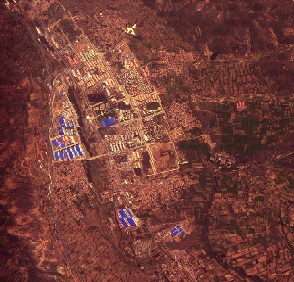
9 Airborne MERSI images(dunhuang)
10 InfraRed Atmospheric Sounder (IRAS) Channel Centre wavenumbe r (cm -1 ) Centre WaveLength (μm) Semi-power band width (cm -1 ) absorption Maximum Temperature (K) NEΔN (mw/m 2 -sr-cm -1 ) Detection Height (hpa) CO 2 CO 2 CO 2 CO 2 CO 2 CO 2 /H 2 O CO 2 /H 2 O Window Surface Window Surface O H 2 O H 2 O H 2 O N 2 O N 2 O CO 2 /N 2 O CO 2 /N 2 O * * * * CO * Atmosphere Window * Surface Window 100%A 0.10%A Cloud window 100%A 0.10%A Surface H 2 O 100%A 0.10%A Surface H 2 O 100%A 0.10%A Surface H 2 O 100%A 0.10%A Surface H 2 O 100%A 0.10%A surface
11 MicroWave Temperature Sounder(MWTS) Observation Angle ±48.3 Pixels/scan 15 Scanning step angle 6.9 Nadir view Resolution 50~75Km Channel Match accuracy Beam pointing error<0.1 Scan Time 16sec channel Centre Frequency (GHz) Absorpt ion Band width (MHz) NEΔT (k) Main beam Efficienc y(%) Dynamic Range (K) Calibration Accuracy (K) Window * > ±0.115 O > O > O >
12 MicroWave Humidity Sounder (MWHS) Observation Angle ±53.35 Swath Width ~2700 Km Pixel/scan 98 Nadir resolution ~15Km Channel Match accuracy Beam Pointing error<0.1 Scan Time 2.667sec Calibration Accuracy 1.5K Channel Centre Frequency (GHz) Absorbt ion Band width (MHz) NEΔT * (k) Main beam efficie ncy Dynamic Range(K) 1 150(V) Window % ** (H) Window % ** ±1 H 2 O % ±3 H 2 O % ±7 H 2 O % 3-340
13 Airborne MWHS images(qinhai Lake)
![[ 注 1]: 第一颗星无该通道 [ 注 2]: 第一颗星分别为 :0.](/docs-images/78/76848178/images/14-3.jpg "6 1K 1K 1K 2K MWRI Instrument")
14 [ 注 1]: 第一颗星无该通道 [ 注 2]: 第一颗星分别为 :0.6 1K 1K 1K 2K MWRI Instrument characteristics
15 Solar Backscatter Ultraviolet Sounder (SBUS) Earth Mode:12 channels in 250~340nm for retrieving O 3 vertical profile. channel Central wavelength(nm) bandpass (FWHM)(nm) ± , ± , ± , ± , ± , ± , ± , ± , ± , ± , ± , ± ,-0 Cloud Cover Radiometer ± sweep solar mode:consecutive scanning for measuring solar irradiance in 160~400nm, step length:0.21nm; Discrete solar mode: discrete scanning for measuring solar irradiances of 12 channels.
16 1.Spectral properties Total Ozone Unit (TOU) channel Central wavelength(nm) bandpass(fwhm)(nm) ± , ± , ± , ± , ± , ± ,-0 2.Dynamic range: Noise: μw/cm 2 sr nm(s/n=1) 4. cross-track scanning mode :perpendicular to the orbital plane in 3.6- degree steps from 54 degrees on one side of spacecraft nadir to 54 degrees on the other side, for a total of 31 samples. 5.scanning cycle time:8.16s 6.Relative radiometric calibration accuray:radiance irradiance: 2%; wavelength calibration accuray: 0.03nm 7.Diffuser BRDF calibration accuray: 3% 8. 量化等级 :12 bits(with 3 gain ranges) 9. Stray light :< Spatial resolution (nadir ground size) :~50Km(altitude:836Km) 11. Diffuser calibration mode and wavelength calibration mode are performed in-orbit and data are received by ground station
17 Requirements for the Characteristics of the Earth s s Radiation Budget instruments Characteristics for narrow FOV/scanning channels I. For solar radiation measurement 1. Dynamic Range:100~2000W/m 2 2. Waveband:0.2~50μm 3. Sensitivity:0.2Wm Accuracy:0.5% 5. long-term stability in 2 years:<0.02% 6. Quantization level:16bit channel 0.2~>3.8μm 0.2~50μm FOV Scanning range ±50 ±50 Dynamic range 0~370Wm -2 Sr -1 0~500Wm -2 Sr -1 accuracy * 1% 0.8% sensitivity 0.4Wm -2 Sr Wm -2 Sr -1 Long-term stability in 2 yaers ** <1% <1% Characteristics for wide FOV/non-scanning channels II. For Earth s radiation measurement This instrument Consists of two groups of channels,which use wide FOV/non-scanning and narrow FOV/scanning observation mode respectively. For wide FOV channels,the sample cycle for earth observation is 0.5s. For narrow FOV channels,one scan cycle consists of 151 sampling channel 0.2~>3.8μm 0.2~50μm FOV Dynamic range 0~370Wm -2 Sr -1 0~500Wm -2 Sr -1 accuracy * 1% 0.8% sensitivity 0.4Wm -2 Sr Wm -2 Sr -1 Long-term stability in 2 yaers ** <1% <1%
18 FY3 Ground Station:Global data receiving ability Global data receiving within 2-3 hours


19 FY Project's Nine (9) Specific Science Themes Nature Hazard Water Resources Land & Ocean Ecosystem uman Health Energy Agriculture & Desertificati on Weather forcast Climate change Biodivers ity


20 1.Weather 1.Atmosphere Temperature profile hPa 2.Atmosphere humidity profile hPa 3. geopotential height hPa 4.Atmosphere stability index 5.OLR 6.Aerosol above sea 7.Preciple water content 8.Total water vapor content 9.Cloud mask 9.Cloud top temperature 10.Cloud optical depth 11.Cloud classification 12.Cloud amount(cloud total amount, High cloud amount) 13.mirage 14.precipation 15.Convective system strength estimation 16.Microwave surface emissivity 17.Polar area wind vector 18.Ice and water route depth index


21 50 2&3 climate change 1.Cloud amount(cloud total amount, High cloud amount) 2.Snow cover 3.SWE 4.OLR 5.SST 6.Vegetation distribution and change detection 7.land-atmosphere system net radiation 8.Total water vapor content 9.precipatation 10.aerosol 11.Soil moisture 12.Drought monitoring 13.Cloud water content 14. Ice and water route depth index Clouud Amount Cloud Optical Thickness Year Year Cloud Water path Year


22 4 Agriculture and Ecosystem 1. Landcover 2.Vegetation index 3.LAI 4.FPAR 5.NPP 6.LST 7.Soil moisture 8.Albedo 9.Snow cover 10.Surface emissivity


23 5 Atmospheric components 1.aerosol 2.sandstorm 3.Total Ozone content 4.Ozone profile 5. Greenhouse gases


24 6 Weather modification Cloud mask cloud total amount, High cloud amount fog Cloud top temperature Cloud optical depth precipitation

25 7.spaceweather proton ion electron Electric potential radiation dose Radiation Fluxe high energy ion


26 8 Thunder Severe convective system satellite monitoring image Cloud Phase Deep convective index Cloud Top Temperature Thunderstorms V-type Storm Top Temp C Large Ice Particles left:yellow-high cloud,blue-thin cirrus,wheat-middle cloud,green-low cloud


27 3.Future Plan of FenYun meteorological satellite Project Polar-orbit series FY 1A 1B 1C 1D FY 3A 3B 3C 3H The first Generation The new generation Geostationary series FY 2A 2B 2C 2D 2E FY 4
 2016FY-4WEST1 2017FY-4MS (TEST) 2020 FY-4MS 2019FY-3RM2 2018FY-3PM3 2016FY-3RM1 2017FY-3AM3 2020 FY-4WEST2 2019 FY-4EAST2")
28 Roadmap of FenYun satellite 2011FY-3AM1 2012FY-2G 2012FY-3PM1 2013FY-4A (TEST) 2010FY-2F 2013FY-3RM (TEST) 2009FY-3B (TEST) 2014FY-3AM2 2008FY-2E 2006FY-2D Science Target: Global all weather, multispectral 3D detection 2015FY-4EAST1 2015FY-3PM2 2007FY-3A (TEST) 2016FY-4WEST1 2017FY-4MS (TEST) 2020 FY-4MS 2019FY-3RM2 2018FY-3PM3 2016FY-3RM1 2017FY-3AM FY-4WEST FY-4EAST2

29 China Rainradar Measurement (RM) Plan The main objectives of RM satellite: 1. Consist a Global observation constellation system with FY3-2 AM and PM satellites, as well as GPM satellite; 2. Improve the severe convective system monitoring ability in china together with GPM satellite; 3. Provide 3D precipitation structure over both ocean and land; 4. Improve the sensitivity and accuracy of precipitation measurement over china and arrounding area;
30 Orbit and attitude 1).orbit parameters ⑴orbit type:low earth-orbiting (LEO) non-sunsynchronous satellites ⑵Orbit altitude:450km ⑶orbit angle:65 ⑹Eccentricity: ).satellite attitude ⑴attitude control type:three-axis Stabilize ⑵pointing control accuracy: 0.2 ⑶measurement accuracy: 0.03 ⑷Attitude Control Stability: /s
31 The core instrument-pr Detection Frequencies Ku Ka Antenna type Active Phased Array Active Phased Array Polarization VV or HH VV or HH Range reso 250 m 250 m/500 m Horizontal Reso 5 km (at nadir) 5 km (at nadir) sensitivity 17dBZ(0.5mm/h) 11dBZ(0.2mm/h) Detection accuracy within ±1 db within ±1 db

32 Stop Here
CMA Consideration on early-morning orbit satellite
 CMA Consideration on early-morning orbit satellite National Satellite Meteorological Center,CMA Yang Jun CGMS 40 in Lugano, 5-9 Nov., 2012 Outline Background Gap analysis on the sounding data coverage
The current status of FY-3D
 The current status of FY-3D Xiang Fang National Satellite Meteorological Center, China Meteorological Administration (NSMC/CMA) OUTLINE Overview Key instruments onboard FY-3D Products and data service
Progress on CMA s Meteorological Satellites
 CMA report on ET SAT 6, Geneva, April 12 16, 11 Progress on CMA s Meteorological Satellites YANG Jun Director General, National Satellite Meteorological Center, CMA 1 FENGYUN satellite programs Current
The current status of FY-3D. (Submitted by Xiang Fang, CMA) Summary and Purpose of Document
 Summary and Purpose of Document") WORLD METEOROLOGICAL ORGANIZATION COMMISSION FOR BASIC SYSTEMS OPEN PROGRAMME AREA GROUP ON INTEGRATED OBSERVING SYSTEMS INTER-PROGRAMME EXPERT TEAM ON SATELLITE UTILIZATION AND PRODUCTS FOURTH SESSION
WORLD METEOROLOGICAL ORGANIZATION COMMISSION FOR BASIC SYSTEMS OPEN PROGRAMME AREA GROUP ON INTEGRATED OBSERVING SYSTEMS INTER-PROGRAMME EXPERT TEAM ON SATELLITE UTILIZATION AND PRODUCTS FOURTH SESSION
Updates on CMA FENGYUN Meteorological Satellite Programs
 Updates on CMA FENGYUN Meteorological Satellite Programs Peng ZHANG National Satellite Meteorological Center, China Meteorological Administration (NSMC/CMA) 29 Nov. - 5 Dec. 2017, Darmstadt, Germany 1.
Interpretation of Polar-orbiting Satellite Observations. Atmospheric Instrumentation
 Interpretation of Polar-orbiting Satellite Observations Outline Polar-Orbiting Observations: Review of Polar-Orbiting Satellite Systems Overview of Currently Active Satellites / Sensors Overview of Sensor
F O U N D A T I O N A L C O U R S E
 F O U N D A T I O N A L C O U R S E December 6, 2018 Satellite Foundational Course for JPSS (SatFC-J) F O U N D A T I O N A L C O U R S E Introduction to Microwave Remote Sensing (with a focus on passive
The Status Report of FY-2F
 Seventh Session of the Expert Team on Satellite Utilization and Products The Status Report of FY-2F Presented by Xiang Fang National Satellite Meteorological Center (NSMC) China Meteorological Administration
Status report on the current and future satellite systems by CMA. Presented to CGMS46-CMA-WP-01, Plenary session, agenda item D.1
 Status report on the current and future satellite systems by CMA Presented to CGMS46-CMA-WP-01, Plenary session, agenda item D.1 Overview - Planning of CMA satellite systems FengYun Meteorological Satellites
Instrumentation planned for MetOp-SG
 Instrumentation planned for MetOp-SG Bill Bell Satellite Radiance Assimilation Group Met Office Crown copyright Met Office Outline Background - the MetOp-SG programme The MetOp-SG instruments Summary Acknowledgements:
Brief introduction to. National Satellite Meteorological Center, CMA. Jinsong Wang Deputy Director-General NSMC/CMA
 Brief introduction to National Satellite Meteorological Center, CMA Jinsong Wang Deputy Director-General NSMC/CMA Rio de Janerio, Oct. 12-15, 10 Beijing Guangzhou Urumuqi Jiamusi 2 NSMC DPC@NSMC KIRUNA
McIDAS support of Suomi-NPP /JPSS and GOES-R L2
 McIDAS support of Suomi-NPP /JPSS and GOES-R L2 William Straka III 1 Tommy Jasmin 1, Bob Carp 1 1 Cooperative Institute for Meteorological Satellite Studies, Space Science and Engineering Center, University
Preparation for FY-4A. (Submitted by Xiang Fang, CMA)
") WORLD METEOROLOGICAL ORGANIZATION COMMISSION FOR BASIC SYSTEMS OPEN PROGRAMME AREA GROUP ON INTEGRATED OBSERVING SYSTEMS EXPERT TEAM ON SATELLITE UTILIZATION AND PRODUCTS ET-SUP-8/Doc. 10.3 (2.IV.2014)
WORLD METEOROLOGICAL ORGANIZATION COMMISSION FOR BASIC SYSTEMS OPEN PROGRAMME AREA GROUP ON INTEGRATED OBSERVING SYSTEMS EXPERT TEAM ON SATELLITE UTILIZATION AND PRODUCTS ET-SUP-8/Doc. 10.3 (2.IV.2014)
Training on FY 3 product suite
 Training on FY 3 product suite Xiang Fang National Satellite Meteorological Center,CMA Outline Status of FY 3 satellite Training Actions Training Plan Status of FY 3 satellite Currently On Orbit Satellites:
REVISION OF THE STATEMENT OF GUIDANCE FOR GLOBAL NUMERICAL WEATHER PREDICTION. (Submitted by Dr. J. Eyre)
") WORLD METEOROLOGICAL ORGANIZATION Distr.: RESTRICTED CBS/OPAG-IOS (ODRRGOS-5)/Doc.5, Add.5 (11.VI.2002) COMMISSION FOR BASIC SYSTEMS OPEN PROGRAMME AREA GROUP ON INTEGRATED OBSERVING SYSTEMS ITEM: 4 EXPERT
WORLD METEOROLOGICAL ORGANIZATION Distr.: RESTRICTED CBS/OPAG-IOS (ODRRGOS-5)/Doc.5, Add.5 (11.VI.2002) COMMISSION FOR BASIC SYSTEMS OPEN PROGRAMME AREA GROUP ON INTEGRATED OBSERVING SYSTEMS ITEM: 4 EXPERT
APPLICATIONS WITH METEOROLOGICAL SATELLITES. W. Paul Menzel. Office of Research and Applications NOAA/NESDIS University of Wisconsin Madison, WI
 APPLICATIONS WITH METEOROLOGICAL SATELLITES by W. Paul Menzel Office of Research and Applications NOAA/NESDIS University of Wisconsin Madison, WI July 2004 Unpublished Work Copyright Pending TABLE OF CONTENTS
Use of FY-3C/GNOS Data for Assessing the on-orbit Performance of Microwave Sounding Instruments
 Use of FY-3C/GNOS Data for Assessing the on-orbit Performance of Microwave Sounding Instruments Xiuqing Hu 1 Xueyan Hou 2, and Mi Liao 1 1 National Satellite Meteorological Center (NSMC), CMA 2 Chinese
Lecture 19: Operational Remote Sensing in Visible, IR, and Microwave Channels
 MET 4994 Remote Sensing: Radar and Satellite Meteorology MET 5994 Remote Sensing in Meteorology Lecture 19: Operational Remote Sensing in Visible, IR, and Microwave Channels Before you use data from any
Xiang FNAG National Satellite Meteorological Center, China Meteorological Administration (NSMC/CMA)
") CMA Fengyun Meteorological Satellite Program Xiang FNAG National Satellite Meteorological Center, China Meteorological Administration (NSMC/CMA) Outline Overview Current Missions Latest Progress Future
CMA Fengyun Meteorological Satellite Program Xiang FNAG National Satellite Meteorological Center, China Meteorological Administration (NSMC/CMA) Outline Overview Current Missions Latest Progress Future
Atmospheric Lidar The Atmospheric Lidar (ATLID) is a high-spectral resolution lidar and will be the first of its type to be flown in space.
 is a high-spectral resolution lidar and will be the first of its type to be flown in space.") www.esa.int EarthCARE mission instruments ESA s EarthCARE satellite payload comprises four instruments: the Atmospheric Lidar, the Cloud Profiling Radar, the Multi-Spectral Imager and the Broad-Band Radiometer.
www.esa.int EarthCARE mission instruments ESA s EarthCARE satellite payload comprises four instruments: the Atmospheric Lidar, the Cloud Profiling Radar, the Multi-Spectral Imager and the Broad-Band Radiometer.
VALIDATION OF INSAT-3D DERIVED RAINFALL. (Submitted by Suman Goyal, IMD) Summary and Purpose of Document
 Summary and Purpose of Document") WORLD METEOROLOGICAL ORGANIZATION COMMISSION FOR BASIC SYSTEMS OPEN PROGRAMME AREA GROUP ON INTEGRATED OBSERVING SYSTEMS INTER-PROGRAMME EXPERT TEAM ON SATELLITE UTILIZATION AND PRODUCTS SECOND SESSION
WORLD METEOROLOGICAL ORGANIZATION COMMISSION FOR BASIC SYSTEMS OPEN PROGRAMME AREA GROUP ON INTEGRATED OBSERVING SYSTEMS INTER-PROGRAMME EXPERT TEAM ON SATELLITE UTILIZATION AND PRODUCTS SECOND SESSION
Joint Polar Satellite System. 3 rd Post-EPS User Consultation Workshop Mike Haas
 3 rd Post-EPS User Consultation Workshop Mike Haas Overview Introduction - Policy Drivers - Management System Description - Space Segment - Ground Segment Partnerships Status Benefits 2 Introduction (Policy
MSG system over view
 MSG system over view 1 Introduction METEOSAT SECOND GENERATION Overview 2 MSG Missions and Services 3 The SEVIRI Instrument 4 The MSG Ground Segment 5 SAF Network 6 Conclusions METEOSAT SECOND GENERATION
APPENDIX 2 OVERVIEW OF THE GLOBAL PRECIPITATION MEASUREMENT (GPM) AND THE TROPICAL RAINFALL MEASURING MISSION (TRMM) 2-1
 AND THE TROPICAL RAINFALL MEASURING MISSION (TRMM) 2-1") APPENDIX 2 OVERVIEW OF THE GLOBAL PRECIPITATION MEASUREMENT (GPM) AND THE TROPICAL RAINFALL MEASURING MISSION (TRMM) 2-1 1. Introduction Precipitation is one of most important environmental parameters.
APPENDIX 2 OVERVIEW OF THE GLOBAL PRECIPITATION MEASUREMENT (GPM) AND THE TROPICAL RAINFALL MEASURING MISSION (TRMM) 2-1 1. Introduction Precipitation is one of most important environmental parameters.
The use and impacts of sea surface temperature from passive microwave measurements
 The use and impacts of sea surface temperature from passive microwave measurements Anne O Carroll 6/12/2017 ECMWF workshop on using low frequency passive microwave measurements in research and operational
Status report on the current and future meteorological satellite systems by CMA
 Status report on the current and future meteorological satellite systems by CMA Presented to CGMS-44Plenary session, agenda item [D.1] Overview - Planning of China satellite systems by year 2025 NSIP:
Status of Indian Satellite Meteorological Programme
 Status of Indian Satellite Meteorological Programme Pradeep K Thapliyal Space Applications Centre (SAC) Indian Space research Organisation (ISRO) Ahmedabad (INDIA) Email: pkthapliyal@sac.isro.gov.in International
Evaluation of Satellite and Reanalysis Products of Downward Surface Solar Radiation over East Asia
 International Workshop on Land Use/Cover Changes and Air Pollution in Asia August 4-7th, 2015, Bogor, Indonesia Evaluation of Satellite and Reanalysis Products of Downward Surface Solar Radiation over
JAXA Remote Sensing Satellite Missions Utilization for Earth and Environment Observation
 JAXA Remote Sensing Satellite Missions Utilization for Earth and Environment Observation 27 th June 2013 Toshiyoshi Kimura EORC/JAXA Inventory, Modeling and Climate Impacts of Greenhouse Gas emissions
The EarthCARE mission: An active view on aerosols, clouds and radiation
 The EarthCARE mission: An active view on aerosols, clouds and radiation T. Wehr, P. Ingmann, T. Fehr Heraklion, Crete, Greece 08/06/2015 EarthCARE is ESA s sixths Earth Explorer Mission and will be implemented
Introduction of the Hyperspectral Environmental Suite (HES) on GOES-R and beyond
 on GOES-R and beyond") Introduction of the Hyperspectral Environmental Suite (HES) on GOES-R and beyond Timothy J. Schmit SaTellite Applications and Research (STAR) Advanced Satellite Products Team (ASPT) Presented by Jun Li
Introduction of the Hyperspectral Environmental Suite (HES) on GOES-R and beyond Timothy J. Schmit SaTellite Applications and Research (STAR) Advanced Satellite Products Team (ASPT) Presented by Jun Li
Lecture 4b: Meteorological Satellites and Instruments. Acknowledgement: Dr. S. Kidder at Colorado State Univ.
 Lecture 4b: Meteorological Satellites and Instruments Acknowledgement: Dr. S. Kidder at Colorado State Univ. US Geostationary satellites - GOES (Geostationary Operational Environmental Satellites) US
GCOM-W1 now on the A-Train
 GCOM-W1 now on the A-Train GCOM-W1 Global Change Observation Mission-Water Taikan Oki, K. Imaoka, and M. Kachi JAXA/EORC (& IIS/The University of Tokyo) Mini-Workshop on A-Train Science, March 8 th, 2013
Update on SCOPE-Nowcasting Pilot Project Real Time Ocean Products Suman Goyal Scientist-E
 Update on SCOPE-Nowcasting Pilot Project Real Time Ocean Products Suman Goyal Scientist-E 19-22 Nov 2013 SCOPE-Nowcasting-1 Agenda Item 5 Pilot Projects Overview Users /Clients User requirements Product
Lecture 4: Meteorological Satellites and Instruments. Acknowledgement: Dr. S. Kidder at Colorado State Univ.
 Lecture 4: Meteorological Satellites and Instruments Acknowledgement: Dr. S. Kidder at Colorado State Univ. Homework for the Spring Break: get some tangible, preliminary results for your final project.
GCOM-C/SGLI and its Lunar Calibration
 GCOM-C/SGLI and its Lunar Calibration Lunar Calibration Workshop December 1-4, 2014 JAXA/GCOM Proj. Yoshihiko Okamura (okamura.yoshihiko@jaxa.jp) 1. Overview of GCOM-C satellite and SGLI (1) Global Change
Topics: Visible & Infrared Measurement Principal Radiation and the Planck Function Infrared Radiative Transfer Equation
 Review of Remote Sensing Fundamentals Allen Huang Cooperative Institute for Meteorological Satellite Studies Space Science & Engineering Center University of Wisconsin-Madison, USA Topics: Visible & Infrared
Climate & Earth System Science. Introduction to Meteorology & Climate. Chapter 05 SOME OBSERVING INSTRUMENTS. Instrument Enclosure.
 Climate & Earth System Science Introduction to Meteorology & Climate MAPH 10050 Peter Lynch Peter Lynch Meteorology & Climate Centre School of Mathematical Sciences University College Dublin Meteorology
Future Opportunities of Using Microwave Data from Small Satellites for Monitoring and Predicting Severe Storms
 Future Opportunities of Using Microwave Data from Small Satellites for Monitoring and Predicting Severe Storms Fuzhong Weng Environmental Model and Data Optima Inc., Laurel, MD 21 st International TOV
Lecture 4: Radiation Transfer
 Lecture 4: Radiation Transfer Spectrum of radiation Stefan-Boltzmann law Selective absorption and emission Reflection and scattering Remote sensing Importance of Radiation Transfer Virtually all the exchange
METEOSAT THIRD GENERATION
 METEOSAT THIRD GENERATION FACTS AND FIGURES MONITORING WEATHER AND CLIMATE FROM SPACE A HIGHLY INNOVATIVE GEOSTATIONARY SATELLITE SYSTEM FOR EUROPE AND AFRICA The Meteosat Third Generation (MTG) system
Spectrum of Radiation. Importance of Radiation Transfer. Radiation Intensity and Wavelength. Lecture 3: Atmospheric Radiative Transfer and Climate
 Lecture 3: Atmospheric Radiative Transfer and Climate Radiation Intensity and Wavelength frequency Planck s constant Solar and infrared radiation selective absorption and emission Selective absorption
PASSIVE MICROWAVE IMAGING. Dr. A. Bhattacharya
 1 PASSIVE MICROWAVE IMAGING Dr. A. Bhattacharya 2 Basic Principles of Passive Microwave Imaging Imaging with passive microwave is a complementary technology that needs an introduction to identify its role
BUFR Table D List of common sequences
 BUFR Table D List of common sequences F X Category of sequences Identifier NONE Category 01 Location and identification sequences (Temperature and humidity instrumentation) 3 01 130 0 03 002 Generic type
Lecture 3: Atmospheric Radiative Transfer and Climate
 Lecture 3: Atmospheric Radiative Transfer and Climate Solar and infrared radiation selective absorption and emission Selective absorption and emission Cloud and radiation Radiative-convective equilibrium
MONITORING WEATHER AND CLIMATE FROM SPACE
 MONITORING WEATHER AND CLIMATE FROM SPACE EUMETSAT Report on New Services Anders Meier Soerensen New X/L-band antenna, Greenland Athens: New 3.0 m L/X-band antenna New 2.4 m L/Xband antenna Installations
CGMS Baseline. Sustained contributions to the Global Observing System. Endorsed by CGMS-46 in Bengaluru, June 2018
 CGMS Baseline Sustained contributions to the Global Observing System Best Practices for Achieving User Readiness for New Meteorological Satellites Endorsed by CGMS-46 in Bengaluru, June 2018 CGMS/DOC/18/1028862,
Lectures 7 and 8: 14, 16 Oct Sea Surface Temperature
 Lectures 7 and 8: 14, 16 Oct 2008 Sea Surface Temperature References: Martin, S., 2004, An Introduction to Ocean Remote Sensing, Cambridge University Press, 454 pp. Chapter 7. Robinson, I. S., 2004, Measuring
Yi Liu TanSat Science Team
 12th International Workshop on Greenhouse Gas Measurements from Space The Pre Launch Status of TanSat Mission Yi Liu TanSat Science Team Institute of Atmospheric Physics, Chinese Academy of Sciences 9
EUMETSAT STATUS AND PLANS
 1 EUM/TSS/VWG/15/826793 07/10/2015 EUMETSAT STATUS AND PLANS François Montagner, Marine Applications Manager, EUMETSAT WMO Polar Space Task Group 5 5-7 October 2015, DLR, Oberpfaffenhofen PSTG Strategic
Earth Exploration-Satellite Service (EESS)- Active Spaceborne Remote Sensing and Operations
- Active Spaceborne Remote Sensing and Operations") Earth Exploration-Satellite Service (EESS)- Active Spaceborne Remote Sensing and Operations SRTM Radarsat JASON Seawinds TRMM Cloudsat Bryan Huneycutt (USA) Charles Wende (USA) WMO, Geneva, Switzerland
Earth Exploration-Satellite Service (EESS)- Active Spaceborne Remote Sensing and Operations SRTM Radarsat JASON Seawinds TRMM Cloudsat Bryan Huneycutt (USA) Charles Wende (USA) WMO, Geneva, Switzerland
Remote Sensing of Precipitation
 Lecture Notes Prepared by Prof. J. Francis Spring 2003 Remote Sensing of Precipitation Primary reference: Chapter 9 of KVH I. Motivation -- why do we need to measure precipitation with remote sensing instruments?
Remote Sensing I: Basics
 Remote Sensing I: Basics Kelly M. Brunt Earth System Science Interdisciplinary Center, University of Maryland Cryospheric Science Laboratory, Goddard Space Flight Center kelly.m.brunt@nasa.gov (Based on
Remote Sensing in Meteorology: Satellites and Radar. AT 351 Lab 10 April 2, Remote Sensing
 Remote Sensing in Meteorology: Satellites and Radar AT 351 Lab 10 April 2, 2008 Remote Sensing Remote sensing is gathering information about something without being in physical contact with it typically
GSICS UV Sub-Group Activities
 GSICS UV Sub-Group Activities Rosemary Munro with contributions from NOAA, NASA and GRWG UV Subgroup Participants, in particular L. Flynn 1 CEOS Atmospheric Composition Virtual Constellation Meeting (AC-VC)
GIFTS SOUNDING RETRIEVAL ALGORITHM DEVELOPMENT
 P2.32 GIFTS SOUNDING RETRIEVAL ALGORITHM DEVELOPMENT Jun Li, Fengying Sun, Suzanne Seemann, Elisabeth Weisz, and Hung-Lung Huang Cooperative Institute for Meteorological Satellite Studies (CIMSS) University
CGMS Baseline In response to CGMS action/recommendation A45.01 HLPP reference: 1.1.8
 Prepared by WGIII Agenda Item: 7.1 Discussed in WGIII CGMS Baseline In response to CGMS action/recommendation A45.01 HLPP reference: 1.1.8 In CGMS-45, Working Group III agreed to hold a review of the CGMS
Assimilation of satellite derived soil moisture for weather forecasting
 Assimilation of satellite derived soil moisture for weather forecasting www.cawcr.gov.au Imtiaz Dharssi and Peter Steinle February 2011 SMOS/SMAP workshop, Monash University Summary In preparation of the
HY-2A Satellite User s Guide
 National Satellite Ocean Application Service 2013-5-16 Document Change Record Revision Date Changed Pages/Paragraphs Edit Description i Contents 1 Introduction to HY-2 Satellite... 1 2 HY-2 satellite data
An Evaluation of FY-3C MWHS-2 and its potential to improve forecast accuracy at ECMWF
 An Evaluation of FY-3C MWHS-2 and its potential to improve forecast accuracy at ECMWF Heather Lawrence, final-year EUMETSAT fellow, ECMWF Supervised by: Niels Bormann & Stephen English Slide 1 China s
Meteorological Satellite Image Interpretations, Part III. Acknowledgement: Dr. S. Kidder at Colorado State Univ.
 Meteorological Satellite Image Interpretations, Part III Acknowledgement: Dr. S. Kidder at Colorado State Univ. Dates EAS417 Topics Jan 30 Introduction & Matlab tutorial Feb 1 Satellite orbits & navigation
NEW CGMS BASELINE FOR THE SPACE-BASED GOS. (Submitted by the WMO Secretariat) Summary and Purpose of Document
 Summary and Purpose of Document") WORLD METEOROLOGICAL ORGANIZATION COMMISSION FOR BASIC SYSTEMS OPEN PROGRAMME AREA GROUP ON INTEGRATED OBSERVING SYSTEMS EXPERT TEAM ON SATELLITE SYSTEMS ET-SAT-7/Inf. 2 (12.III.2012) ITEM: 8.1 SEVENTH
WORLD METEOROLOGICAL ORGANIZATION COMMISSION FOR BASIC SYSTEMS OPEN PROGRAMME AREA GROUP ON INTEGRATED OBSERVING SYSTEMS EXPERT TEAM ON SATELLITE SYSTEMS ET-SAT-7/Inf. 2 (12.III.2012) ITEM: 8.1 SEVENTH
Radiative Transfer Model based Bias Correction in INSAT-3D/3DR Thermal Observations to Improve Sea Surface Temperature Retrieval
 Radiative Transfer Model based Bias Correction in INSAT-3D/3DR Thermal Observations to Improve Sea Surface Temperature Retrieval Rishi K Gangwar, Buddhi P Jangid, and Pradeep K Thapliyal Space Applications
Remote Sensing: Introduction
 Curso Intensivo sobre Asimilación de Datos 27 de Octubre - 7 de Noviembre de 2008 Aula Magna, Pabellon I, Ciudad Universitaria Buenos Aires, Argentina Remote Sensing: Introduction Inés Velasco Departamento
A 2016 CEOS Chair Initiative. Non-meteorological Applications for Next Generation Geostationary Satellites
 A 2016 CEOS Chair Initiative Committee on Earth Observation Satellites Non-meteorological Applications for Next Generation Geostationary Satellites Co-chaired by EUMETSAT (Holmlund), CSIRO (Schroeder),
REMOTE SENSING KEY!!
 REMOTE SENSING KEY!! This is a really ugly cover page I m sorry. Name Key. Score / 100 Directions: You have 50 minutes to take this test. You may use a cheatsheet (2 pages), a non-graphing calculator,
IASI Level 2 Product Processing
 IASI Level 2 Product Processing Dieter Klaes for Peter Schlüssel Arlindo Arriaga, Thomas August, Xavier Calbet, Lars Fiedler, Tim Hultberg, Xu Liu, Olusoji Oduleye Page 1 Infrared Atmospheric Sounding
Variability in Global Top-of-Atmosphere Shortwave Radiation Between 2000 And 2005
 Variability in Global Top-of-Atmosphere Shortwave Radiation Between 2000 And 2005 Norman G. Loeb NASA Langley Research Center Hampton, VA Collaborators: B.A. Wielicki, F.G. Rose, D.R. Doelling February
THE FEASIBILITY OF EXTRACTING LOWLEVEL WIND BY TRACING LOW LEVEL MOISTURE OBSERVED IN IR IMAGERY OVER CLOUD FREE OCEAN AREA IN THE TROPICS
 THE FEASIBILITY OF EXTRACTING LOWLEVEL WIND BY TRACING LOW LEVEL MOISTURE OBSERVED IN IR IMAGERY OVER CLOUD FREE OCEAN AREA IN THE TROPICS Toshiro Ihoue and Tetsuo Nakazawa Meteorological Research Institute
Remote Sensing How we know what we know A Brief Tour
 Remote Sensing How we know what we know A Brief Tour Dr. Erik Richard Dr. Jerald Harder LASP Richard 1 Remote Sensing The measurement of physical variables (usually light or sound) from outside of a medium
EPS-SG Candidate Observation Missions
 EPS-SG Candidate Observation Missions 3 rd Post-EPS User Consultation Workshop Peter Schlüssel Slide: 1 EPS-SG benefits to activities of NMSs Main Payload High-Resolution Infrared Sounding Microwave Sounding
Operational Uses of Bands on the GOES-R Advanced Baseline Imager (ABI) Presented by: Kaba Bah
 Presented by: Kaba Bah") Operational Uses of Bands on the GOES-R Advanced Baseline Imager (ABI) Presented by: Kaba Bah Topics: Introduction to GOES-R & ABI ABI individual bands Use of band differences ABI derived products Conclusions
Operational Uses of Bands on the GOES-R Advanced Baseline Imager (ABI) Presented by: Kaba Bah Topics: Introduction to GOES-R & ABI ABI individual bands Use of band differences ABI derived products Conclusions
Principles of Radiative Transfer Principles of Remote Sensing. Marianne König EUMETSAT
 - Principles of Radiative Transfer Principles of Remote Sensing Marianne König EUMETSAT marianne.koenig@eumetsat.int Remote Sensing All measurement processes which perform observations/measurements of
ABB Remote Sensing Atmospheric Emitted Radiance Interferometer AERI system overview. Applications
 The ABB Atmospheric Emitted Radiance Interferometer AERI provides thermodynamic profiling, trace gas detection, atmospheric cloud aerosol study, air quality monitoring, and more. AERI high level overview
FUNDAMENTALS OF REMOTE SENSING FOR RISKS ASSESSMENT. 1. Introduction
 FUNDAMENTALS OF REMOTE SENSING FOR RISKS ASSESSMENT FRANÇOIS BECKER International Space University and University Louis Pasteur, Strasbourg, France; E-mail: becker@isu.isunet.edu Abstract. Remote sensing
Next generation of EUMETSAT microwave imagers and sounders: new opportunities for cloud and precipitation retrieval
 Next generation of EUMETSAT microwave imagers and sounders: new opportunities for cloud and precipitation retrieval Christophe Accadia, Sabatino Di Michele, Vinia Mattioli, Jörg Ackermann, Sreerekha Thonipparambil,
A two-season impact study of the Navy s WindSat surface wind retrievals in the NCEP global data assimilation system
 A two-season impact study of the Navy s WindSat surface wind retrievals in the NCEP global data assimilation system Li Bi James Jung John Le Marshall 16 April 2008 Outline WindSat overview and working
Radio Frequency Earth Science
 Radio Frequency Earth Science Overview for Committee On Radio Frequency (CORF) National Academy of Science National Research Council April 27, 2005 Bill.Watson@NASA.Gov Program Executive for Ground Networks
Comparison of NASA AIRS and MODIS Land Surface Temperature and Infrared Emissivity Measurements from the EOS AQUA platform
 Comparison of NASA AIRS and MODIS Land Surface Temperature and Infrared Emissivity Measurements from the EOS AQUA platform Robert Knuteson, Steve Ackerman, Hank Revercomb, Dave Tobin University of Wisconsin-Madison
Day Microphysics RGB Nephanalysis in daytime. Meteorological Satellite Center, JMA
 Day Microphysics RGB Nephanalysis in daytime Meteorological Satellite Center, JMA What s Day Microphysics RGB? R : B04 (N1 0.86) Range : 0~100 [%] Gamma : 1.0 G : B07(I4 3.9) (Solar component) Range :
Inventory & Evaluation of Space-based Instruments: Using OSCAR for space weather
 WMO OMM World Meteorological Organization Working together in weather, climate and water Inventory & Evaluation of Space-based Instruments: Using OSCAR for space weather Jérôme Lafeuille (WMO) Alain Hilgers
REMOTE SENSING TEST!!
 REMOTE SENSING TEST!! This is a really ugly cover page I m sorry. Name. Score / 100 Directions: (idk if I need to put this???) You have 50 minutes to take this test. You may use a cheatsheet (2 pages),
Future GOES (XGOHI, GOES-13/O/P, GOES-R+)
") Future GOES (XGOHI, GOES-13/O/P, GOES-R+) Timothy J. Schmit NOAA/NESDIS/Satellite Applications and Research Advanced Satellite Products Branch (ASPB) Madison, WI And many others MUG Meeting October 16,
Future GOES (XGOHI, GOES-13/O/P, GOES-R+) Timothy J. Schmit NOAA/NESDIS/Satellite Applications and Research Advanced Satellite Products Branch (ASPB) Madison, WI And many others MUG Meeting October 16,
Observations of Integrated Water Vapor and Cloud Liquid Water at SHEBA. James Liljegren
 Observations of Integrated Water Vapor and Cloud Liquid Water at SHEBA James Liljegren Ames Laboratory Ames, IA 515.294.8428 liljegren@ameslab.gov Introduction In the Arctic water vapor and clouds influence
Glaciology HEAT BUDGET AND RADIATION
 HEAT BUDGET AND RADIATION A Heat Budget 1 Black body radiation Definition. A perfect black body is defined as a body that absorbs all radiation that falls on it. The intensity of radiation emitted by a
Study of the Influence of Thin Cirrus Clouds on Satellite Radiances Using Raman Lidar and GOES Data
 Study of the Influence of Thin Cirrus Clouds on Satellite Radiances Using Raman Lidar and GOES Data D. N. Whiteman, D. O C. Starr, and G. Schwemmer National Aeronautics and Space Administration Goddard
CLAVR-x is the Clouds from AVHRR Extended Processing System. Responsible for AVHRR cloud products and other products at various times.
 CLAVR-x in CSPP Andrew Heidinger, NOAA/NESDIS/STAR, Madison WI Nick Bearson, SSEC, Madison, WI Denis Botambekov, CIMSS, Madison, WI Andi Walther, CIMSS, Madison, WI William Straka III, CIMSS, Madison,
New capabilities with high resolution cloud micro-structure facilitated by MTG 2.3 um channel
 Slide 19 November 2016, V1.0 New capabilities with high resolution cloud micro-structure facilitated by MTG 2.3 um channel Author: Daniel Rosenfeld The Hebrew University of Jerusalem (HUJ) daniel.rosenfeld@huji.ac.il
What are Aerosols? Suspension of very small solid particles or liquid droplets Radii typically in the range of 10nm to
 What are Aerosols? Suspension of very small solid particles or liquid droplets Radii typically in the range of 10nm to 10µm Concentrations decrease exponentially with height N(z) = N(0)exp(-z/H) Long-lived
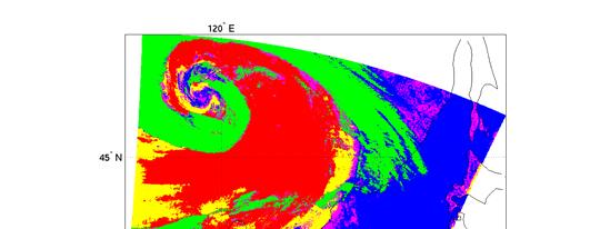
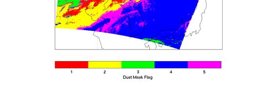
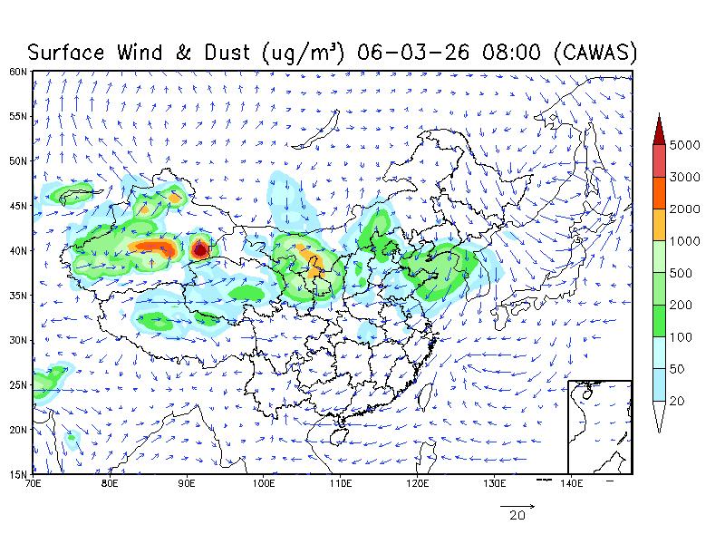
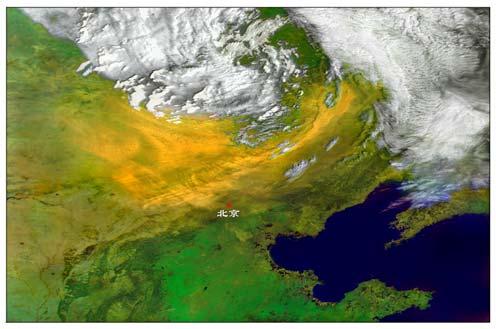
Satellite observation of atmospheric dust
 Satellite observation of atmospheric dust Taichu Y. Tanaka Meteorological Research Institute, Japan Meteorological Agency 11 April 2017, SDS WAS: Dust observation and modeling @WMO, Geneva Dust observations
Megha-Tropiques Presentation by Indian Delegation at the 55th Session of UNCOPUOS Vienna 12 June 2012
 Megha-Tropiques Presentation by Indian Delegation at the 55 th Session of UNCOPUOS Vienna 12 June 2012 Megha-Tropiques Mission Indo-French Joint Satellite for studying tropical atmosphere Megha in Sanskrit
Earth s Energy Budget: How Is the Temperature of Earth Controlled?
 1 NAME Investigation 2 Earth s Energy Budget: How Is the Temperature of Earth Controlled? Introduction As you learned from the reading, the balance between incoming energy from the sun and outgoing energy
Name(s) Period Date. Earth s Energy Budget: How Is the Temperature of Earth Controlled?
 Period Date. Earth s Energy Budget: How Is the Temperature of Earth Controlled?") Name(s) Period Date 1 Introduction Earth s Energy Budget: How Is the Temperature of Earth Controlled? As you learned from the reading, the balance between incoming energy from the sun and outgoing energy
Name(s) Period Date 1 Introduction Earth s Energy Budget: How Is the Temperature of Earth Controlled? As you learned from the reading, the balance between incoming energy from the sun and outgoing energy
GEOSC/METEO 597K Kevin Bowley Kaitlin Walsh
 GEOSC/METEO 597K Kevin Bowley Kaitlin Walsh Timeline of Satellites ERS-1 (1991-2000) NSCAT (1996) Envisat (2002) RADARSAT (2007) Seasat (1978) TOPEX/Poseidon (1992-2005) QuikSCAT (1999) Jason-2 (2008)
A New Era: Three-Dimensional Observation and Service with Fully High Resolutions on FY-4 Platform are Coming Next Year
 6 th Asia/Oceania Meteorological Satellite Users Conference A New Era: Three-Dimensional Observation and Service with Fully High Resolutions on FY-4 Platform are Coming Next Year Presented by Qiang Guo
Changes in Earth s Albedo Measured by satellite
 Changes in Earth s Albedo Measured by satellite Bruce A. Wielicki, Takmeng Wong, Norman Loeb, Patrick Minnis, Kory Priestley, Robert Kandel Presented by Yunsoo Choi Earth s albedo Earth s albedo The climate
THE LAND-SAF SURFACE ALBEDO AND DOWNWELLING SHORTWAVE RADIATION FLUX PRODUCTS
 THE LAND-SAF SURFACE ALBEDO AND DOWNWELLING SHORTWAVE RADIATION FLUX PRODUCTS Bernhard Geiger, Dulce Lajas, Laurent Franchistéguy, Dominique Carrer, Jean-Louis Roujean, Siham Lanjeri, and Catherine Meurey
OCEAN COLOUR MONITOR ON-BOARD OCEANSAT-2
 OCEAN COLOUR MONITOR ON-BOARD OCEANSAT-2 Rangnath R Navalgund Space Applications Centre Indian Space Research Organisation Ahmedabad-380015, INDIA OCEANSAT-2 2 MISSION OCEANSAT-2 2 is a global mission
Sentinel-3 Sea and Land Surface Temperature Radiometer (SLSTR) Mireya Etxaluze (STFC RAL Space)
 Mireya Etxaluze (STFC RAL Space)") Sentinel-3 Sea and Land Surface Temperature Radiometer (SLSTR) Mireya Etxaluze (STFC RAL Space) RAL Space Radiometry Group Dave Smith Mireya Etxaluze, Ed Polehampton, Caroline Cox, Tim Nightingale, Dan
Sentinel-3 Sea and Land Surface Temperature Radiometer (SLSTR) Mireya Etxaluze (STFC RAL Space) RAL Space Radiometry Group Dave Smith Mireya Etxaluze, Ed Polehampton, Caroline Cox, Tim Nightingale, Dan
Updates on Chinese Meteorological Satellite Programs
 6 th Asia/Oceania Meteorological Satellite Users Conference Updates on Chinese Meteorological Satellite Programs Caiying Wei Deputy director-general of NSMC National Satellite Meteorological Center (NSMC)