Progress on CMA s Meteorological Satellites
|
|
|
- Ariel May
- 5 years ago
- Views:
Transcription


1 CMA report on ET SAT 6, Geneva, April 12 16, 11 Progress on CMA s Meteorological Satellites YANG Jun Director General, National Satellite Meteorological Center, CMA 1
 FY 3A/B(R&D, polar) Future Satellite Programs FY 3C/D/E/F (operational, polar) FY 3/RM (rainfull measurement, low inclination) FY 4A(R&D, geo) FY 4B/C (operational, geo.")
2 FENGYUN satellite programs Current Satellite Programs FY 1D(operational, polar) FY 2D/E(operational, geo.) FY 3A/B(R&D, polar) Future Satellite Programs FY 3C/D/E/F (operational, polar) FY 3/RM (rainfull measurement, low inclination) FY 4A(R&D, geo) FY 4B/C (operational, geo.) Others EO Satellites (NOAA, Meteosat, MTSAT,EOS etc.) Ground System with 24/7 Satellite operations and data processing FENGYUN satellite constellation
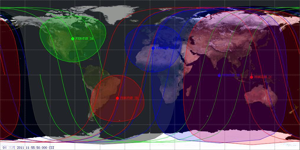


3 Current Satellites In orbit FY 3A FY 1D FY 3B FY 2D 86.5 FY 2E 105 FY 2C 123.5


 Oct.")


4 FengYun GEO. Satellites: FY 2 No. Pos. Status Launch FY 2C 105E Op. (retired) Oct.18, 04 FY 2D 86.5E Op. (working) Dec.8, 06 FY 2E 105E Op. (working) Dec.23,08 Platform: Spin stabilization Payload: 5 chl. VISSR Full Disc: every 30 min. at most FY 2E & FY 2D are working together to implement 15 min. interval obs. FY 2E took over FC 2C in DEC., 09 FY 2C was retired, but still used for rapid scanning mode in case of need FY 2D B: 86.5ºE FY 2E A: 105ºE

5 60min. interval 30min. interval 15min. interval 13 th tropical cyclone Megi (108 Hours)
")


 Solar")


6 Discipline Basic Dataset(L1) Automatic derived product (L2+) Monitoring Product (L2+) Images FY 2 Products: 25 Products+6 Parameters Measurement Calibrated and Navigated dataset(nom) S VISSR(SVS) Cloud Classification/Amount Cloud Motion Winds Precipitation Estimation/Index Outgoing Long wave Radiation SST TBB Upper Troposphere Humidity Humidity Profile from Cloud Perceptible Water (Clear Sky ) Solar Irradiance ISCCP dataset Sand Storm Monitoring Snow Cover Monitoring Fog Monitoring Sea Ice Monitoring Fire Monitoring Flood Monitoring Soil Moisture Monitoring Tropical Cyclone /Typhoon Position and Intensity Segment image Multi Sat Mosaic


7 2 nd Generation of LEO: FY 3 ok FY 3 Constellation (FY 3A:Morning,FY 3B:Afternoon) After FY 3A, FY 3B was successfully launched on Nov. 5, 10 Commission test has been finished by the end of March, 11 FY 3B is expected to be put into use in next month, together with FY 3A 11 instruments on board FY 3A/B, including: VIRR: Visible and Infra Red Radiometer MERSI: Medium Resolution Spectral Imager IRAS: Infrared Atmospheric Sounder MWTS:MicroWave Temperature Sounder MWHS: MicroWave Humidity Sounder MWRI: MicroWave Radiation Imager SBUS: Solar Backscatter Ultraviolet Sounder TOU: Total Ozone mapping Unit SIM: Solar Irritation Monitor ERM: Earth Radiation Monitor SEM: Space Environment Monitor No. FY 3A FY 3B FY 3C FY 3D FY 3E FY 3F Launch May 27,08 Nov 5, (plan) 14(plan) 16(plan) 18(plan) Orbit M A M A M A Status R&D R&D Op. Op. Op. Op. 7

8 Converage for NWP data assimilate per 6 hours by FY 3A and FY 3B
 comparing")

9 Mesoscale convective clouds cluster monitoring by FY 3B (afternoon) comparing with FY 3A (morning) The convective clouds developed in the brink of the tropical cyclone CARLOS


10 Dust monitoring in the Arabian Peninsula on 26, March 11 by FY 3A and FY 3B


11 BeforeTsunami, Feb 3, 11 After Tsunami, March 13, 11 True Color composition with 250m resolution byfy 3B MERSI Chl1,2,4 Affected Area


12 Ozone hole near the arctic area Polar stratospheric clouds Total ozone amount


13 Low Ozone Amount Area near North Polar Region FY 3A


14 Global Temperature & Humidity Profile from IRAS/MWTS/MWHS of FY 3B


15 Soil Moisture from MWRI Land Surface Temperature from MWRI Precipitable Water from MWRI Land Emissivity from MWRI

16 Solar Constant from SIM/FY 3B FY-3B/SIM 观测平均日地距离上太阳辐射与美国宇航局 SORCE/TIM 观测对比 Comparison between FY-3B SIM and NASA SORCE/TIM
17 FY 3A/B Instruments Specifications Spatial Name of Number of Swath Width Spectral range Resoluation at Instrument Channels (Km) Sub point (Km) VIRR μm MERSI μm ~ 1 MWRI GHz ~ 85 IRAS μm MWTS GHz ~ 75 MWHS GHz SBUS μm 0 TOU 6 0.3~0.36μm ERM 4 0.2~50 μm SIM 1 0.2~50 μm SEM atmospheric sounding Microwave Imaging Optical Imaging from Km to 250m Atmospheric composition: Ozone Radiation budget for earth system
18 FY 3 Products: 10 L L2 No. Atmosphere & Cloud Ocean Land Atmos Chemistry Space Enviornment 1 Cloud Mask Sea Ice LST Ozone Amount high energy particles radiation dose 2 Cloud Classification Ocean Color NDVI Ozone profile 3 Cloud Height SST Fire 4 Fog Flood & Drought 5 Water Vapor Snow 6 T/Q profile 7 Radiance Budget 8 Precipitation 9 Aerosoal 10 OLR


19 FY 3/RM:Rainfall Measurement Satellite on board Precipitation Radar A member of FY 3 constellation together with FY 3 AM & PM The objectives of FY 3/RM satellite are: To make up a global observation constellation system with FY 3 AM & PM satellites, as well as GPM satellite; To enhance the severe convective system monitoring capability in china together with GPM satellite; To provide 3D precipitation structure over both ocean and land; To improve the sensitivity and accuracy of precipitation measurement over china and arrounding area; Core instrument: Ku/Ka Radar Microwave Sounders: MWTS MWHS MWRI Ka band PR Ku band PR


20 Air borne PR flight experiments finished June Oct. 10 EDU:Ku/Ka dual band PR Zm (cross track, scan 1) height / km scan range / km 10


21 Next Generation of GEO satellite FY 4 4 main instruments Advanced Geo. Radiation Imager Geo. Interferometric InfraRed Sounder Lighting Mapping Imager Solar X EUV imaging telescope (not available on 1 st satellite) No. Plan Launch Design Life Status FY 4A 15 5 years R&D FY 4B 17 7 years Op. FY 4C 19 7 years Op. Prototype structure of FY 4A
22 Major improvements on FY 4 compared with 1 st gen. FY 2 Platform transition from spin stabilization to 3 axis stabilization Higher observation efficiency Flexible area scanning mode Advanced radiation imager Total 216 sensors for 14 bands from visible to long wave infrared Full path on orbit radiation calibration for all bands High temporal resolution from 30min to 15min Spatial resolution from 1.25Km to 500m Define HQ mode to improve S/N Interferometric Infrared Sounder, new capability! 538 LWIR Channels,375 S/MIR Channels High spectrum resolution to enable better atmosphere T&H retrieval Lighting imager, new capability!


 China area: 67min(5000x5000km) Central")
23 AGRI GIIRS LMI Advanced Geo. Radiation Imager Geo. Interferometric Infrared Sounder Lighting Mapping Imager 14 Channels within 0.55~13.8μm 500mx1;1Kmx2 2Kmx4; 4Kmx7 S/N : 90 ~ 0 NEΔT: 0.2~0.7K Full Disk < =15min 538 LWIR Channels 375 S/MIR Channels 16Km Radiometric Calibration accuracy: 1K Spectral Calibration accuracy:10ppm Meso scale : 35min(1000x1000km) China area: 67min(5000x5000km) Central Frequency: 777.4nm 7.8Km S/N > =6 2ms
 Quick")


24 FY 4 Product Family Basic Dataset (L1) Image Products Quantitative Products (L2+) Quick Monitoring Products (L2+) Calibrated and Navigated dataset Aerosol Detection (including Smoke & Dust) Volcanic Ash True color image, Remapped images Detection Cloud Mask Cloud Classification (including Fog) Cloud Amount Cloud Top Heights/Pressure/Temperature/Phase Cloud Ice Water /Liquid Water Path Cloud Particle Size Distribution Visibility Atmospheric Motion Vectors (Cloud Derived Winds) Precipitation Index, Precipitation Estimation Moisture /Temperature /Ozone Profile, Total Ozone /Water Content Absorbed Shortwave Radiation, Reflected Solar Isolation Downward Long wave Radiation Outgoing Long wave Radiation Land Surface (Skin)/Sea/Lake Surface Temperature Overshooting Intensity Convective SO 2 DetectionDetection Fire / HotTyphoon Spot Detection Sand Storm Initiation Flooding Sea Ice, Snow Cover
25 10- FY-3 polar orbiting satellites Launch schedule FY 3B/PM FY 3C/AM FY 3D/PM FY 3E/AM FY 3/ RM1 FY 3F/PM FY 3/ RM2 FY 3G/AM Afternoon orbit Morning orbit Low inclination
26 R2D Transition Plan from FY 2 to FY 4 Previous plan Plan refined: 1) FY 2F is 6 month postponed to the early 12, since FY 2D/E are working well 2) FY 4A is planned 1 year late than previous
27 10- FENGYUN Geostationary Satellites Launch Schedule FY 2 FY 2G FY 2H FY 4A FY 4B FY 4C


28 International cooperation on satellite meteorology and Earth observation Bilateral agreement with NOAA on Satellite Meteorology Satellite Data Exchange, Intercalibration, data assimilation, products development... Cooperation with EUMETSAT Six CMA EUMETSAT bilateral meetings since 1998 Four cooperation agreements between CMA and EUMETSAT on meteorological satellite data application, exchange and redistribution Highlights on CMA s international cooperative activities in 10 The first Asian/Oceania Satellite User Conference, host by CMA, cosponsored by WMO, GEO, JMA, KMA, was successfully hold in Beijing on Nov.2 4, 10. GEO summits was hold in Beijing on Nov, 5 12, 10 CMA/NSMC participated in CEOS plenary meeting in Brazil,and became the member of CEOS.
29 Thank you
Brief introduction to. National Satellite Meteorological Center, CMA. Jinsong Wang Deputy Director-General NSMC/CMA
 Brief introduction to National Satellite Meteorological Center, CMA Jinsong Wang Deputy Director-General NSMC/CMA Rio de Janerio, Oct. 12-15, 10 Beijing Guangzhou Urumuqi Jiamusi 2 NSMC DPC@NSMC KIRUNA
Preparation for FY-4A. (Submitted by Xiang Fang, CMA)
") WORLD METEOROLOGICAL ORGANIZATION COMMISSION FOR BASIC SYSTEMS OPEN PROGRAMME AREA GROUP ON INTEGRATED OBSERVING SYSTEMS EXPERT TEAM ON SATELLITE UTILIZATION AND PRODUCTS ET-SUP-8/Doc. 10.3 (2.IV.2014)
WORLD METEOROLOGICAL ORGANIZATION COMMISSION FOR BASIC SYSTEMS OPEN PROGRAMME AREA GROUP ON INTEGRATED OBSERVING SYSTEMS EXPERT TEAM ON SATELLITE UTILIZATION AND PRODUCTS ET-SUP-8/Doc. 10.3 (2.IV.2014)
Status report on the current and future satellite systems by CMA. Presented to CGMS46-CMA-WP-01, Plenary session, agenda item D.1
 Status report on the current and future satellite systems by CMA Presented to CGMS46-CMA-WP-01, Plenary session, agenda item D.1 Overview - Planning of CMA satellite systems FengYun Meteorological Satellites
CMA Consideration on early-morning orbit satellite
 CMA Consideration on early-morning orbit satellite National Satellite Meteorological Center,CMA Yang Jun CGMS 40 in Lugano, 5-9 Nov., 2012 Outline Background Gap analysis on the sounding data coverage
The current status of FY-3D
 The current status of FY-3D Xiang Fang National Satellite Meteorological Center, China Meteorological Administration (NSMC/CMA) OUTLINE Overview Key instruments onboard FY-3D Products and data service
Status report on the current and future meteorological satellite systems by CMA
 Status report on the current and future meteorological satellite systems by CMA Presented to CGMS-44Plenary session, agenda item [D.1] Overview - Planning of China satellite systems by year 2025 NSIP:
Updates on Chinese Meteorological Satellite Programs
 6 th Asia/Oceania Meteorological Satellite Users Conference Updates on Chinese Meteorological Satellite Programs Caiying Wei Deputy director-general of NSMC National Satellite Meteorological Center (NSMC)
Xiang FNAG National Satellite Meteorological Center, China Meteorological Administration (NSMC/CMA)
") CMA Fengyun Meteorological Satellite Program Xiang FNAG National Satellite Meteorological Center, China Meteorological Administration (NSMC/CMA) Outline Overview Current Missions Latest Progress Future
CMA Fengyun Meteorological Satellite Program Xiang FNAG National Satellite Meteorological Center, China Meteorological Administration (NSMC/CMA) Outline Overview Current Missions Latest Progress Future
The Status Report of FY-2F
 Seventh Session of the Expert Team on Satellite Utilization and Products The Status Report of FY-2F Presented by Xiang Fang National Satellite Meteorological Center (NSMC) China Meteorological Administration
The current status of FY-3D. (Submitted by Xiang Fang, CMA) Summary and Purpose of Document
 Summary and Purpose of Document") WORLD METEOROLOGICAL ORGANIZATION COMMISSION FOR BASIC SYSTEMS OPEN PROGRAMME AREA GROUP ON INTEGRATED OBSERVING SYSTEMS INTER-PROGRAMME EXPERT TEAM ON SATELLITE UTILIZATION AND PRODUCTS FOURTH SESSION
WORLD METEOROLOGICAL ORGANIZATION COMMISSION FOR BASIC SYSTEMS OPEN PROGRAMME AREA GROUP ON INTEGRATED OBSERVING SYSTEMS INTER-PROGRAMME EXPERT TEAM ON SATELLITE UTILIZATION AND PRODUCTS FOURTH SESSION
An Introduction of FY3 Satellite Project ---Status and Future Plan
 7 th GPM workshop An Introduction of FY3 Satellite Project ---Status and Future Plan National Satellite Meteorological Center, CMA Hu Yang Naimeng Lu Dec 04,2007 7 th GPM workshop Contents 1.Introduction
Satellite observation of atmospheric dust
 Satellite observation of atmospheric dust Taichu Y. Tanaka Meteorological Research Institute, Japan Meteorological Agency 11 April 2017, SDS WAS: Dust observation and modeling @WMO, Geneva Dust observations
Interpretation of Polar-orbiting Satellite Observations. Atmospheric Instrumentation
 Interpretation of Polar-orbiting Satellite Observations Outline Polar-Orbiting Observations: Review of Polar-Orbiting Satellite Systems Overview of Currently Active Satellites / Sensors Overview of Sensor
Training on FY 3 product suite
 Training on FY 3 product suite Xiang Fang National Satellite Meteorological Center,CMA Outline Status of FY 3 satellite Training Actions Training Plan Status of FY 3 satellite Currently On Orbit Satellites:
A New Era: Three-Dimensional Observation and Service with Fully High Resolutions on FY-4 Platform are Coming Next Year
 6 th Asia/Oceania Meteorological Satellite Users Conference A New Era: Three-Dimensional Observation and Service with Fully High Resolutions on FY-4 Platform are Coming Next Year Presented by Qiang Guo
McIDAS support of Suomi-NPP /JPSS and GOES-R L2
 McIDAS support of Suomi-NPP /JPSS and GOES-R L2 William Straka III 1 Tommy Jasmin 1, Bob Carp 1 1 Cooperative Institute for Meteorological Satellite Studies, Space Science and Engineering Center, University
Updates on CMA FENGYUN Meteorological Satellite Programs
 Updates on CMA FENGYUN Meteorological Satellite Programs Peng ZHANG National Satellite Meteorological Center, China Meteorological Administration (NSMC/CMA) 29 Nov. - 5 Dec. 2017, Darmstadt, Germany 1.
Update on SCOPE-Nowcasting Pilot Project 1
 Update on SCOPE-Nowcasting Pilot Project 1 Xiang Fang National Satellite Meteorological Center (NSMC) China Meteorological Administration (CMA) Overview Now, China has 6 meteorological satellites in operation.
Jun Park National Meteorological Satellite Center Korea Meteorological Administration
 KMA Implementation Plan for Satellite Climate products Jun Park National Meteorological Satellite Center Korea Meteorological Administration jun.park@kma.go.kr Outline 1. Introduction : Current & Future
Instrumentation planned for MetOp-SG
 Instrumentation planned for MetOp-SG Bill Bell Satellite Radiance Assimilation Group Met Office Crown copyright Met Office Outline Background - the MetOp-SG programme The MetOp-SG instruments Summary Acknowledgements:
Status of Indian Satellite Meteorological Programme
 Status of Indian Satellite Meteorological Programme Pradeep K Thapliyal Space Applications Centre (SAC) Indian Space research Organisation (ISRO) Ahmedabad (INDIA) Email: pkthapliyal@sac.isro.gov.in International
A 2016 CEOS Chair Initiative. Non-meteorological Applications for Next Generation Geostationary Satellites
 A 2016 CEOS Chair Initiative Committee on Earth Observation Satellites Non-meteorological Applications for Next Generation Geostationary Satellites Co-chaired by EUMETSAT (Holmlund), CSIRO (Schroeder),
Preparation for Himawari 8
 Preparation for Himawari 8 Japan Meteorological Agency Meteorological Satellite Center Hidehiko MURATA ET SUP 8, WMO HQ, Geneva, 14 17 April 2014 1/18 Introduction Background The Japan Meteorological Agency
CMA Satellite Programs Supporting SWCEM
 CMA Satellite Programs Supporting SWCEM YANG Jun National Satellite Meteorological Center, CMA Operational Space-based Weather and Climate Extremes Monitoring (SWCEM) Workshop 15-17,Feb., 2017, Geneva,
Arctic Weather Every 10 Minutes: Design & Operation of ABI for PCW
 Arctic Weather Every 10 Minutes: Design and Operation of ABI for PCW Dr. Paul C. Griffith and Sue Wirth 31st Space Symposium, Technical Track, Colorado Springs, Colorado This document is not subject to
REVISION OF THE STATEMENT OF GUIDANCE FOR GLOBAL NUMERICAL WEATHER PREDICTION. (Submitted by Dr. J. Eyre)
") WORLD METEOROLOGICAL ORGANIZATION Distr.: RESTRICTED CBS/OPAG-IOS (ODRRGOS-5)/Doc.5, Add.5 (11.VI.2002) COMMISSION FOR BASIC SYSTEMS OPEN PROGRAMME AREA GROUP ON INTEGRATED OBSERVING SYSTEMS ITEM: 4 EXPERT
WORLD METEOROLOGICAL ORGANIZATION Distr.: RESTRICTED CBS/OPAG-IOS (ODRRGOS-5)/Doc.5, Add.5 (11.VI.2002) COMMISSION FOR BASIC SYSTEMS OPEN PROGRAMME AREA GROUP ON INTEGRATED OBSERVING SYSTEMS ITEM: 4 EXPERT
CGMS Baseline In response to CGMS action/recommendation A45.01 HLPP reference: 1.1.8
 Prepared by WGIII Agenda Item: 7.1 Discussed in WGIII CGMS Baseline In response to CGMS action/recommendation A45.01 HLPP reference: 1.1.8 In CGMS-45, Working Group III agreed to hold a review of the CGMS
Operational Uses of Bands on the GOES-R Advanced Baseline Imager (ABI) Presented by: Kaba Bah
 Presented by: Kaba Bah") Operational Uses of Bands on the GOES-R Advanced Baseline Imager (ABI) Presented by: Kaba Bah Topics: Introduction to GOES-R & ABI ABI individual bands Use of band differences ABI derived products Conclusions
Operational Uses of Bands on the GOES-R Advanced Baseline Imager (ABI) Presented by: Kaba Bah Topics: Introduction to GOES-R & ABI ABI individual bands Use of band differences ABI derived products Conclusions
APPENDIX 2 OVERVIEW OF THE GLOBAL PRECIPITATION MEASUREMENT (GPM) AND THE TROPICAL RAINFALL MEASURING MISSION (TRMM) 2-1
 AND THE TROPICAL RAINFALL MEASURING MISSION (TRMM) 2-1") APPENDIX 2 OVERVIEW OF THE GLOBAL PRECIPITATION MEASUREMENT (GPM) AND THE TROPICAL RAINFALL MEASURING MISSION (TRMM) 2-1 1. Introduction Precipitation is one of most important environmental parameters.
APPENDIX 2 OVERVIEW OF THE GLOBAL PRECIPITATION MEASUREMENT (GPM) AND THE TROPICAL RAINFALL MEASURING MISSION (TRMM) 2-1 1. Introduction Precipitation is one of most important environmental parameters.
6 th ET SAT meeting, April 12 15, Geneva, Switzerland Satellite Programme of KMA
 6 th ET SAT meeting, April 12 15, Geneva, Switzerland Satellite Programme of KMA Korea Meteorological Administration National Meteorological Satellite Center Status of COMS COMS Heritage COM Design & Review
Lecture 4b: Meteorological Satellites and Instruments. Acknowledgement: Dr. S. Kidder at Colorado State Univ.
 Lecture 4b: Meteorological Satellites and Instruments Acknowledgement: Dr. S. Kidder at Colorado State Univ. US Geostationary satellites - GOES (Geostationary Operational Environmental Satellites) US
The use and impacts of sea surface temperature from passive microwave measurements
 The use and impacts of sea surface temperature from passive microwave measurements Anne O Carroll 6/12/2017 ECMWF workshop on using low frequency passive microwave measurements in research and operational
FUTURE PLAN AND RECENT ACTIVITIES FOR THE JAPANESE FOLLOW-ON GEOSTATIONARY METEOROLOGICAL SATELLITE HIMAWARI-8/9
 FUTURE PLAN AND RECENT ACTIVITIES FOR THE JAPANESE FOLLOW-ON GEOSTATIONARY METEOROLOGICAL SATELLITE HIMAWARI-8/9 Toshiyuki Kurino Japan Meteorological Agency, 1-3-4 Otemachi Chiyodaku, Tokyo 100-8122,
Future GOES (XGOHI, GOES-13/O/P, GOES-R+)
") Future GOES (XGOHI, GOES-13/O/P, GOES-R+) Timothy J. Schmit NOAA/NESDIS/Satellite Applications and Research Advanced Satellite Products Branch (ASPB) Madison, WI And many others MUG Meeting October 16,
Future GOES (XGOHI, GOES-13/O/P, GOES-R+) Timothy J. Schmit NOAA/NESDIS/Satellite Applications and Research Advanced Satellite Products Branch (ASPB) Madison, WI And many others MUG Meeting October 16,
CGMS Baseline. Sustained contributions to the Global Observing System. Endorsed by CGMS-46 in Bengaluru, June 2018
 CGMS Baseline Sustained contributions to the Global Observing System Best Practices for Achieving User Readiness for New Meteorological Satellites Endorsed by CGMS-46 in Bengaluru, June 2018 CGMS/DOC/18/1028862,
MONITORING WEATHER AND CLIMATE FROM SPACE
 MONITORING WEATHER AND CLIMATE FROM SPACE EUMETSAT Report on New Services Anders Meier Soerensen New X/L-band antenna, Greenland Athens: New 3.0 m L/X-band antenna New 2.4 m L/Xband antenna Installations
EUMETSAT products and services for monitoring storms - New missions, more data and more meteorological products
 EUMETSAT products and services for monitoring storms - New missions, more data and more meteorological products Jochen Grandell 1 EUM/RSP/VWG/17/921460 Outline Overview of EUMETSAT missions Current...and
MSG system over view
 MSG system over view 1 Introduction METEOSAT SECOND GENERATION Overview 2 MSG Missions and Services 3 The SEVIRI Instrument 4 The MSG Ground Segment 5 SAF Network 6 Conclusions METEOSAT SECOND GENERATION
Lecture 19: Operational Remote Sensing in Visible, IR, and Microwave Channels
 MET 4994 Remote Sensing: Radar and Satellite Meteorology MET 5994 Remote Sensing in Meteorology Lecture 19: Operational Remote Sensing in Visible, IR, and Microwave Channels Before you use data from any
NOAA Report. Hal Bloom Mitch Goldberg NOAA/NESDIS
 NOAA Report Hal Bloom Mitch Goldberg NOAA/NESDIS Summary of Major Events at NESDIS (of interest to ITSC) NOAA/NASA addressing NPOESS Climate Sensors Letter of agreement signed with JAXA on GCOM interagency
H-SAF future developments on Convective Precipitation Retrieval
 H-SAF future developments on Convective Precipitation Retrieval Francesco Zauli 1, Daniele Biron 1, Davide Melfi 1, Antonio Vocino 1, Massimiliano Sist 2, Michele De Rosa 2, Matteo Picchiani 2, De Leonibus
VALIDATION OF INSAT-3D DERIVED RAINFALL. (Submitted by Suman Goyal, IMD) Summary and Purpose of Document
 Summary and Purpose of Document") WORLD METEOROLOGICAL ORGANIZATION COMMISSION FOR BASIC SYSTEMS OPEN PROGRAMME AREA GROUP ON INTEGRATED OBSERVING SYSTEMS INTER-PROGRAMME EXPERT TEAM ON SATELLITE UTILIZATION AND PRODUCTS SECOND SESSION
WORLD METEOROLOGICAL ORGANIZATION COMMISSION FOR BASIC SYSTEMS OPEN PROGRAMME AREA GROUP ON INTEGRATED OBSERVING SYSTEMS INTER-PROGRAMME EXPERT TEAM ON SATELLITE UTILIZATION AND PRODUCTS SECOND SESSION
ESA Status Report. ET-SAT-11, WMO, Geneva, CH, 4 April Prepared by Earth Observation Programmes Directorate
 ESA Status Report ET-SAT-11, WMO, Geneva, CH, 4 April 2017 Prepared by Earth Observation Programmes Directorate Presented by Ivan Petiteville, ESA, Earth Observation Programmes Issue/Revision: 0.0 Reference:
NEW CGMS BASELINE FOR THE SPACE-BASED GOS. (Submitted by the WMO Secretariat) Summary and Purpose of Document
 Summary and Purpose of Document") WORLD METEOROLOGICAL ORGANIZATION COMMISSION FOR BASIC SYSTEMS OPEN PROGRAMME AREA GROUP ON INTEGRATED OBSERVING SYSTEMS EXPERT TEAM ON SATELLITE SYSTEMS ET-SAT-7/Inf. 2 (12.III.2012) ITEM: 8.1 SEVENTH
WORLD METEOROLOGICAL ORGANIZATION COMMISSION FOR BASIC SYSTEMS OPEN PROGRAMME AREA GROUP ON INTEGRATED OBSERVING SYSTEMS EXPERT TEAM ON SATELLITE SYSTEMS ET-SAT-7/Inf. 2 (12.III.2012) ITEM: 8.1 SEVENTH
ISRO Report on the Status of Current and future satellites. Presented to CGMS-44 WP-01 Plenary Session
 ISRO Report on the Status of Current and future satellites Presented to CGMS-44 WP-01 Plenary Session CGMS-44-ISRO 05-10 June 2016 Indian Satellite System for weather parameters Satellite Oceansat-1/ MSMR
Update on SCOPE-Nowcasting Pilot Project Real Time Ocean Products Suman Goyal Scientist-E
 Update on SCOPE-Nowcasting Pilot Project Real Time Ocean Products Suman Goyal Scientist-E 19-22 Nov 2013 SCOPE-Nowcasting-1 Agenda Item 5 Pilot Projects Overview Users /Clients User requirements Product
WMO SCOPE-Nowcasting using new-generation satellite data: Progress and Perspectives
 WMO SCOPE-Nowcasting using new-generation satellite data: Progress and Perspectives Stephan Bojinski WMO Space Programme 8 th Asia-Oceania Meteorological Satellite Users Conference Vladivostok, Russia,
Recent Progress of Fengyun Meteorology Satellites
 Recent Progress of Fengyun Meteorology Satellites ZHANG Peng, CHEN Lin, XIAN di, XU Zhe (National Satellite Meteorological Center/National Center for Space Weather, China Meteorological Administration,
EUMETSAT PLANS. Dr. K. Dieter Klaes EUMETSAT Am Kavalleriesand 31 D Darmstadt Germany
 EUMETSAT PLANS Dr. K. Dieter Klaes EUMETSAT Am Kavalleriesand 31 D-64295 Darmstadt Germany Page 1 EUMETSAT SATELLITE PROGRAMMES 96 97 98 99 00 01 02 03 04 05 06 07 08 09 10 11 12 13 14 15 16 17 18 METEOSAT
GCOM-W1 now on the A-Train
 GCOM-W1 now on the A-Train GCOM-W1 Global Change Observation Mission-Water Taikan Oki, K. Imaoka, and M. Kachi JAXA/EORC (& IIS/The University of Tokyo) Mini-Workshop on A-Train Science, March 8 th, 2013
Introduction of the Hyperspectral Environmental Suite (HES) on GOES-R and beyond
 on GOES-R and beyond") Introduction of the Hyperspectral Environmental Suite (HES) on GOES-R and beyond Timothy J. Schmit SaTellite Applications and Research (STAR) Advanced Satellite Products Team (ASPT) Presented by Jun Li
Introduction of the Hyperspectral Environmental Suite (HES) on GOES-R and beyond Timothy J. Schmit SaTellite Applications and Research (STAR) Advanced Satellite Products Team (ASPT) Presented by Jun Li
APPLICATIONS WITH METEOROLOGICAL SATELLITES. W. Paul Menzel. Office of Research and Applications NOAA/NESDIS University of Wisconsin Madison, WI
 APPLICATIONS WITH METEOROLOGICAL SATELLITES by W. Paul Menzel Office of Research and Applications NOAA/NESDIS University of Wisconsin Madison, WI July 2004 Unpublished Work Copyright Pending TABLE OF CONTENTS
Current and Upcoming NASA Hurricane Measurement Missions National Hurricane Conference
 NASA Science Mission Directorate Earth Science Division Applied Sciences Program Current and Upcoming NASA Hurricane Measurement Missions National Hurricane Conference April 18, 2017 Formulation Implementation
GOES-R. Getting ready for the next generation earth observing system. Yuguang He AER April 10, 2015
 GOES-R Getting ready for the next generation earth observing system Yuguang He AER April 10, 2015 Outline! AER in research and applica0ons! AER on GOES- R! GOES- R: the next genera0on! Ge:ng ready for
Radiative Transfer Model based Bias Correction in INSAT-3D/3DR Thermal Observations to Improve Sea Surface Temperature Retrieval
 Radiative Transfer Model based Bias Correction in INSAT-3D/3DR Thermal Observations to Improve Sea Surface Temperature Retrieval Rishi K Gangwar, Buddhi P Jangid, and Pradeep K Thapliyal Space Applications
Future Opportunities of Using Microwave Data from Small Satellites for Monitoring and Predicting Severe Storms
 Future Opportunities of Using Microwave Data from Small Satellites for Monitoring and Predicting Severe Storms Fuzhong Weng Environmental Model and Data Optima Inc., Laurel, MD 21 st International TOV
Development of Tropical cyclone objective analysis technique based on FY serial satellite data
 2 nd International Workshop On Satellite Analysis of Tropical Cyclones (IWSATC-2) Update on Objective Satellite-Based TC Analysis Methods 18 February 2016 Honolulu, Hawaii, USA Development of Tropical
Usage of McIDAS V with GOES R AWG products
 McIDAS User Group Meeting, October 25-27, 2010, Madison, WI Usage of McIDAS V with GOES R AWG products William Straka III UW/CIMSS Madison, Wisconsin, USA With help from Tom Rink (CIMSS/), Tom Achtor (CIMSS/),
International Cooperation in Operational Environmental Satellites: The U.S. Experience
 Committee on the Peaceful Uses of Outer Space Science and Technology Sub committee Forty seventh session February 17, 2010 Vienna, Austria International Cooperation in Operational Environmental Satellites:
F O U N D A T I O N A L C O U R S E
 F O U N D A T I O N A L C O U R S E December 6, 2018 Satellite Foundational Course for JPSS (SatFC-J) F O U N D A T I O N A L C O U R S E Introduction to Microwave Remote Sensing (with a focus on passive
The Copernicus Sentinel-5 Mission: Daily Global Data for Air Quality, Climate and Stratospheric Ozone Applications
 SENTINEL-5 The Copernicus Sentinel-5 Mission: Daily Global Data for Air Quality, Climate and Stratospheric Ozone Applications Yasjka Meijer RHEA for ESA, Noordwijk, NL 15/04/2016 Co-Authors: Jörg Langen,
Joint Polar Satellite System. 3 rd Post-EPS User Consultation Workshop Mike Haas
 3 rd Post-EPS User Consultation Workshop Mike Haas Overview Introduction - Policy Drivers - Management System Description - Space Segment - Ground Segment Partnerships Status Benefits 2 Introduction (Policy
Space Based Global Observing System Requirements for Satellite Sounders. Dr. Jian Liu Space Programme World Meteorological Organization
 Space Based Global Observing System Requirements for Satellite Sounders Dr. Jian Liu Space Programme World Meteorological Organization Outline 1. satellite sounders capabilities 2. User requirements 3.
EUMETSAT STATUS AND PLANS
 1 EUM/TSS/VWG/15/826793 07/10/2015 EUMETSAT STATUS AND PLANS François Montagner, Marine Applications Manager, EUMETSAT WMO Polar Space Task Group 5 5-7 October 2015, DLR, Oberpfaffenhofen PSTG Strategic
Evaluation of FY-3B data and an assessment of passband shifts in AMSU-A and MSU during the period
 Interim report of Visiting Scientist mission NWP_11_05 Document NWPSAF-EC-VS-023 Version 0.1 28 March 2012 Evaluation of FY-3B data and an assessment of passband Qifeng Lu 1 and William Bell 2 1. China
METEOSAT THIRD GENERATION
 METEOSAT THIRD GENERATION FACTS AND FIGURES MONITORING WEATHER AND CLIMATE FROM SPACE A HIGHLY INNOVATIVE GEOSTATIONARY SATELLITE SYSTEM FOR EUROPE AND AFRICA The Meteosat Third Generation (MTG) system
An Evaluation of FY-3C MWHS-2 and its potential to improve forecast accuracy at ECMWF
 An Evaluation of FY-3C MWHS-2 and its potential to improve forecast accuracy at ECMWF Heather Lawrence, final-year EUMETSAT fellow, ECMWF Supervised by: Niels Bormann & Stephen English Slide 1 China s
Applications of the SEVIRI window channels in the infrared.
 Applications of the SEVIRI window channels in the infrared jose.prieto@eumetsat.int SEVIRI CHANNELS Properties Channel Cloud Gases Application HRV 0.7 Absorption Scattering
Vision for the space-based component of WIGOS in 2040
 Vision for the space-based component of WIGOS in 2040 Stephan Bojinski, WMO Space Programme Toshiyuki Kurino, WMO Space Programme Corresponds to version 1.1 of the 2040 Vision Document 2017 GRWG/GDWG Annual
Status of ESA EO Programmes
 Status of ESA EO Programmes 54 th ESSC Plenary Meeting 24 November 2017 Maurice Borgeaud, ESA Head of the ESA Earth Observation Science, Applications and Climate Department Issue/Revision: 0.0 Reference:
Evaluation of Satellite and Reanalysis Products of Downward Surface Solar Radiation over East Asia
 International Workshop on Land Use/Cover Changes and Air Pollution in Asia August 4-7th, 2015, Bogor, Indonesia Evaluation of Satellite and Reanalysis Products of Downward Surface Solar Radiation over
CNES Activity Report. Patrice Henry - CNES WGCV Plenary # 41 Tokyo Sept. 5-7, Working Group on Calibration and Validation
 Activity Report Patrice Henry - Tokyo Sept. 5-7, 2016 Working Group on Calibration and Validation SUMMARY Calibration Monitoring of in-flight Missions Preparation of future Missions Involvement in CEOS/WGCV
JAXA Remote Sensing Satellite Missions Utilization for Earth and Environment Observation
 JAXA Remote Sensing Satellite Missions Utilization for Earth and Environment Observation 27 th June 2013 Toshiyoshi Kimura EORC/JAXA Inventory, Modeling and Climate Impacts of Greenhouse Gas emissions
STATUS OF JAPANESE METEOROLOGICAL SATELLITES AND RECENT ACTIVITIES OF MSC
 STATUS OF JAPANESE METEOROLOGICAL SATELLITES AND RECENT ACTIVITIES OF MSC Daisaku Uesawa Meteorological Satellite Center, Japan Meteorological Agency Abstract MTSAT-1R is the current operational Japanese
How to display RGB imagery by SATAID
 How to display RGB imagery by SATAID Akihiro SHIMIZU Meteorological Satellite Center (MSC), Japan Meteorological Agency (JMA) Ver. 2015110500 RGB imagery on SATAID SATAID software has a function of overlapping
Lecture 4: Meteorological Satellites and Instruments. Acknowledgement: Dr. S. Kidder at Colorado State Univ.
 Lecture 4: Meteorological Satellites and Instruments Acknowledgement: Dr. S. Kidder at Colorado State Univ. Homework for the Spring Break: get some tangible, preliminary results for your final project.
Radio Frequency Earth Science
 Radio Frequency Earth Science Overview for Committee On Radio Frequency (CORF) National Academy of Science National Research Council April 27, 2005 Bill.Watson@NASA.Gov Program Executive for Ground Networks
EUMETSAT Data and Services for Climate Services and Research. Jörg Schulz
 EUMETSAT Data and Services for Climate Services and Research Jörg Schulz 1 WMO Workshop on Operational Space-based Weather and Climate Extremes Monitoring, WMO HQ, Geneva, Switzerland, 15-17 February 2017
REMOTE SENSING KEY!!
 REMOTE SENSING KEY!! This is a really ugly cover page I m sorry. Name Key. Score / 100 Directions: You have 50 minutes to take this test. You may use a cheatsheet (2 pages), a non-graphing calculator,
Megha-Tropiques Presentation by Indian Delegation at the 55th Session of UNCOPUOS Vienna 12 June 2012
 Megha-Tropiques Presentation by Indian Delegation at the 55 th Session of UNCOPUOS Vienna 12 June 2012 Megha-Tropiques Mission Indo-French Joint Satellite for studying tropical atmosphere Megha in Sanskrit
Application of Himawari-8 AHI Data to the GOES-R Rainfall Rate Algorithm
 Application of Himawari-8 AHI Data to the GOES-R Rainfall Rate Algorithm Yaping Li 1, Robert Kuligowski 2 and Yan Hao 1 1. IMSG at NOAA/NESDIS/STAR 2. NOAA/NESDIS/STAR, College Park, MD 1 GOES-R Baseline
Introduction of the Hyperspectral Environmental Suite (HES) on GOES-R and beyond
 on GOES-R and beyond") Introduction of the Hyperspectral Environmental Suite (HES) on GOES-R and beyond 1 Timothy J. Schmit, 2 Jun Li, 3 James Gurka 1 NOAA/NESDIS, Office of Research and Applications, Advanced Satellite Products
Introduction of the Hyperspectral Environmental Suite (HES) on GOES-R and beyond 1 Timothy J. Schmit, 2 Jun Li, 3 James Gurka 1 NOAA/NESDIS, Office of Research and Applications, Advanced Satellite Products
The ESA Earth observation programmes overview and outlook
 The ESA Earth observation programmes overview and outlook Dr. Volker Liebig Director, ESA EO Programmes ILA 2008, Berlin ENVISAT mission: 6 years! Bam earthquake Tectonic uplift (Andaman) Arctic 2007 First
Next generation of EUMETSAT microwave imagers and sounders: new opportunities for cloud and precipitation retrieval
 Next generation of EUMETSAT microwave imagers and sounders: new opportunities for cloud and precipitation retrieval Christophe Accadia, Sabatino Di Michele, Vinia Mattioli, Jörg Ackermann, Sreerekha Thonipparambil,
Non-meteorological Applications for Next Generation Geostationary Satellites: A 2016 CEOS Chair Initiative
 Committee on Earth Observation Satellites Non-meteorological Applications for Next Generation Geostationary Satellites: A 2016 CEOS Chair Initiative Ian Grant, Australian Bureau of Meteorology (Adapted
Use of FY-3C/GNOS Data for Assessing the on-orbit Performance of Microwave Sounding Instruments
 Use of FY-3C/GNOS Data for Assessing the on-orbit Performance of Microwave Sounding Instruments Xiuqing Hu 1 Xueyan Hou 2, and Mi Liao 1 1 National Satellite Meteorological Center (NSMC), CMA 2 Chinese
The Earth Explorer Missions - Current Status
 EOQ N 66 July 2000 meteorology earthnet remote sensing solid earth future programmes Earth Observation Quarterly The Earth Explorer Missions - Current Status G. Mégie (1) and C.J. Readings (2) (1) Institut
Spaceborne Wind Lidar Observations by Aeolus Data Products and Pre-Launch Validation with an Airborne Instrument
 DRAGON 3 Project ID 10532 Cal/Val Spaceborne Wind Lidar Observations by Aeolus Data Products and Pre-Launch Validation with an Airborne Instrument Reitebuch Oliver, Lemmerz Christian, Marksteiner Uwe,
Status of the Sentinel-5 Precursor Presented by C. Zehner S5p, S4, and S5 Missions Manager - ESA
 Status of the Sentinel-5 Precursor Presented by C. Zehner S5p, S4, and S5 Missions Manager - ESA European response to global needs: to manage the environment, to mitigate the effects of climate change
EPS-SG Candidate Observation Missions
 EPS-SG Candidate Observation Missions 3 rd Post-EPS User Consultation Workshop Peter Schlüssel Slide: 1 EPS-SG benefits to activities of NMSs Main Payload High-Resolution Infrared Sounding Microwave Sounding
Meteorological Satellite Image Interpretations, Part III. Acknowledgement: Dr. S. Kidder at Colorado State Univ.
 Meteorological Satellite Image Interpretations, Part III Acknowledgement: Dr. S. Kidder at Colorado State Univ. Dates EAS417 Topics Jan 30 Introduction & Matlab tutorial Feb 1 Satellite orbits & navigation
History of Aerosol Remote Sensing. Mark Smithgall Maria Zatko 597K Spring 2009
 History of Aerosol Remote Sensing Mark Smithgall Maria Zatko 597K Spring 2009 Aerosol Sources Anthropogenic Biological decomposition from fertilizer and sewage treatment (ex. ammonium) Combustion of fossil
A two-season impact study of the Navy s WindSat surface wind retrievals in the NCEP global data assimilation system
 A two-season impact study of the Navy s WindSat surface wind retrievals in the NCEP global data assimilation system Li Bi James Jung John Le Marshall 16 April 2008 Outline WindSat overview and working
Land Surface Temperature Measurements From the Split Window Channels of the NOAA 7 Advanced Very High Resolution Radiometer John C.
 Land Surface Temperature Measurements From the Split Window Channels of the NOAA 7 Advanced Very High Resolution Radiometer John C. Price Published in the Journal of Geophysical Research, 1984 Presented
The Transition of Atmospheric Infrared Sounder Total Ozone Products to Operations
 The Transition of Atmospheric Infrared Sounder Total Ozone Products to Operations Emily Berndt 1, Bradley Zavodsky 2, Gary Jedlovec 2 1 NASA Postdoctoral Program Marshall Space Flight Center, Huntsville,
All-sky assimilation of MHS and HIRS sounder radiances
 All-sky assimilation of MHS and HIRS sounder radiances Alan Geer 1, Fabrizio Baordo 2, Niels Bormann 1, Stephen English 1 1 ECMWF 2 Now at Bureau of Meteorology, Australia All-sky assimilation at ECMWF
EUMETSAT SAF NETWORK. Lothar Schüller, EUMETSAT SAF Network Manager
 1 EUMETSAT SAF NETWORK Lothar Schüller, EUMETSAT SAF Network Manager EUMETSAT ground segment overview METEOSAT JASON-2 INITIAL JOINT POLAR SYSTEM METOP NOAA SATELLITES CONTROL AND DATA ACQUISITION FLIGHT
VISION FOR THE GOS IN 2025 ( Approved by CBS-XIV and Adopted by EC LXI in June 2009)
") WORLD METEOROLOGICAL ORGANIZATION Weather Climate Water VISION FOR THE GOS IN 2025 ( Approved by CBS-XIV and Adopted by EC LXI in June 2009) PREAMBLE This Vision provides high-level goals to guide the
WORLD METEOROLOGICAL ORGANIZATION Weather Climate Water VISION FOR THE GOS IN 2025 ( Approved by CBS-XIV and Adopted by EC LXI in June 2009) PREAMBLE This Vision provides high-level goals to guide the
CEOS Overview and JAXA Plans for Water Cycle Observation
 CEOS Overview and JAXA Plans for Water Cycle Observation Asian Water Cycle Symposium November 2-4, 2005 Tokyo, Japan Chu Ishida Japan Aerospace Exploration Agency (JAXA) Contents 1. CEOS overview 2. CEOS
Atmospheric Lidar The Atmospheric Lidar (ATLID) is a high-spectral resolution lidar and will be the first of its type to be flown in space.
 is a high-spectral resolution lidar and will be the first of its type to be flown in space.") www.esa.int EarthCARE mission instruments ESA s EarthCARE satellite payload comprises four instruments: the Atmospheric Lidar, the Cloud Profiling Radar, the Multi-Spectral Imager and the Broad-Band Radiometer.
www.esa.int EarthCARE mission instruments ESA s EarthCARE satellite payload comprises four instruments: the Atmospheric Lidar, the Cloud Profiling Radar, the Multi-Spectral Imager and the Broad-Band Radiometer.