1982 WORK REPORT. Line Cutting, Geochemistry and Geophysics. on the 82F/15 W. SMD Mining Co. Ltd.
|
|
|
- Robert Ramsey
- 5 years ago
- Views:
Transcription
1 1982 WORK REPORT Line Cutting, Geochemistry and Geophysics on the KAS 1, KAS 2, KAS 3, KAS 4, LO 5 CLAIMS (IMP GROUP) S1 ocan Mining Di vision NTS: 82F/15 W LAT: 49"53'N LONG: 116"56'W Owner & Operator: SMD Mining Co. Ltd. K MINERAL RESOURCES CRANCH David T.M. Chan November 1982
2 SUMMARY 1982 work on the KAS 1, 2, 3, 4 and LO 5 claims (IMP Group) near Kaslo, B.C. involved line cutting, soil geochemical and geophysical surveys. These surveys are follow-up work on an airborne electromagnetic survey done in June The soil geochemical survey identified three zinc anomalies, one on the KAS 4 claim (Grid E), and two on the LO 5 claim (Grid F). All three are monoelement anomalies occurring in areas underlain by Jurassic 2ranitic sills or overburden. The CEM shoot-back system confirmed most of the airborne conductors but none of these conductors has correlation with the soil geochemical anomal i es. No sulphide mineralization was found on the grids and no further work is recommended.
3 TABLE OF CONTENTS Page SUMMARY 1. INTRODUCTION (i) Location and Access (i i ) Physiography (iii) Claim Definition (iv) Previous Work 2. LINE CUTTING 3. GEOLOGY 4. GEOCHEMISTRY 5. GEOPHYSICS 6. GRID SUMMARIES 7. CONCLUSIONS AND RECOMMENDATIONS 8. ITEMIZED COST STATEMENT 9. STATEMENT OF QUALIFICATIONS 10. REFERENCES I LIST OF FIGURES FIGURE 1 FIGURE 2 Location Map Claim Map LIST OF MAPS DRAWING 1 DRAWING 2 DRAWING 3 DRANING 4 DRAWING 5 DRAWING 6 Grid Location (1:lO 000) Grid B (1:5 000) Grid C Grid D Grid E Grid F II I1 I1 I1
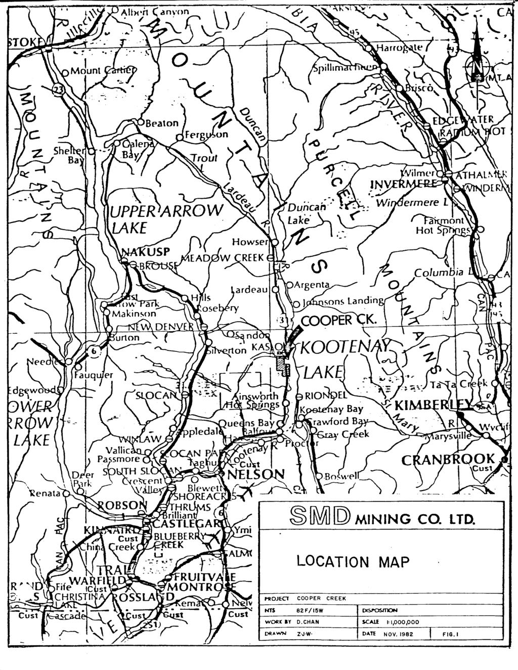
4 1. INTRODUCTION (i) Location and Access The IMP Group claims are located on the southeast flank of True Blue Mountain, 6 km southwest of Kaslo, B.C. Access to the claims is via Highway 31 and an all-weather gravel road southwest of Kaslo (Figure 1). (ii ) Physiography The property area lies in extremely rugged alpine terrain of the Selkirk Mountains in southeastern British Columbia. The property topography shows the strong relief characteristics of mountainous terrain in the adolescent stage of erosion. Spruce, hemlock and fir stands, some of commercial value, extend well above the 2,000 m elevation. The southeastern flank of the rnountain was logged during the early 1970's resulting in a thick regrowth of willow and alder. Forest cover is often cut by natural drainage gullies covered by fallen trees and alder/willow brush. These intermittent stream courses and the strong topographic relief are major obstacles to traversing and grid preparation. (iii) Claim Definition The IMP Group consists of KAS 1, KAS 2, KAS 3, KAS 4 and LO 5 claims totalling 40 units and is located in the Slocan Mining Division (Figure 2). The claims are owned by SMD Mining Co. Ltd. Table 1 Claim Record No. Record Date Units KAS September 2, KAS September 2, KAS September 2, KAS September 2, LO September 13, Claims TOTAL 40 units
5
6 ,.. q -* i I' I I II \ I \ I I TRUE BLUE YOUNTAll KAS- 2 I KAS- I smd MlNiNG CO. LTD. CLAIM MAP 1-50,000 0 loo rnefrer L 3 PPOJCCT COOPER CREEK mwt BY 0. CHAN SCALI 1:50,000 WIUh ZJ-W. I DATE 1982 I FIG.2
7 - 2 - (iv) Previous Work (Fyles 1967). The region was mapp d by the B.C. D artm t of Mines in 1967 The DIGHEM I1 airborne electromagnetic/resistivity/magnetic surveys were flown in June 1982 over the Kaslo area by DIGHEM Limited of Toronto, Ontario under contract with SMD Mining Co. Ltd. 2. LINE CUTTING Line cutting was undertaken to prepare grids over selected airborne EM conductors to facilitate geochemical, geophysical and geological surveys. Bema Industries personnel cut five new grids (B,C,D,E,F) totalling 12.6 km in August, 1982 (Dwg. 1). Stations were established at 25 m intervals (secant chained) by SMD Mining Co. Ltd. personnel. 3. GEOLOGY The project area lies on the western flank of the Kootenay Arc, a major structural element within the Omineca Belt of the Canadian Cordillera (Sutherland-Brown, et al., 1971). The Kaslo area contains a complexly deformed group of volcanic and sedimentary rocks with age ranging from Lower Cambrian to Triassic. Crystalline rocks of the Lardeau Group, of Lower Cambrian to Lower Devonian age, occur along the west shore of Kootenay Lake. Further west, the Mil ford Group unconformably over1 ies the Lardeau Group. The Milford Group, of Mississippian to Permian age, consists of argillite, limestone, dolomite, quartzite and schist. The Kaslo Group, of Permian or Triassic age, overlies the Milford Group rocks in the project area. The Kaslo Group consists of meta-andesite flows and tuffs, with minor felsic pyroclastic rocks (Wheeler and Read, 1976). Overlying the Kaslo Group rocks, to the west of the project area, are argillite, quartzite, phyllite and andesitic tuffs of the Triassic to Lower Jurassic Slocan Group. I
8 - 3 - Small stocks, dykes and sills related to the Nelson batholith (Jurassic to Cretaceous age) cut rocks of the Lardeau, Milford, Kaslo and Slocan Group. 4. GEOCHEMISTRY Soil samples collected on the claims were analyzed for copper, lead, zinc, silver, gold and arsenic. The results are shown on Drawing 3 to 6 (in map pockets). A total of 575 soil samples were collected by SMD Mining Co. Ltd. personnel on grid lines at 25 m intervals. The samples were collected in kraft paper bags from the IIBtt horizon (average depth 15 cm). These samples were shipped to Acme Analytical Laboratories Ltd. in Vancouver where they were dried and sieved to -80 mesh, pulverized to -200 mesh, digested with hot aqua regia, and geochemically analyzed by the Inductively Coupled Argon Plasma (ICP) method. Gold was analyzed by atomic absorption. Analytical results are discussed individually in the summary of each grid. I 5. GEOPHYSICS Ground magnetic and shoot-back electromagnetic surveys were conducted on Grids B, C, D, E and F by an in-house crew during September 1982 to locate airborne EM conductors discovered in an earlier survey (Dvorak, 1982). Magnet i cs The magnetic survey employed a Geornetrics G-816 proton precession magnetometer. Read ngs were taken at 25 m intervals a ong grid lines spaced approximately 200 m apart. Readings were corrected for diurnal drift using a Canadian Mining Geophysics built MR-10 base station recorder. Instrument drift was checked by running the magnetometer traverse in closed loops. The data were plotted in profiles. Results are discussed in the grid summaries.
9 - 4 - Electromaqnetics The EM survey employed a Crone CEM shoot-back unit. The survey was carried out with a 50 m coil separation at three frequencies, 390, 1830 and 5010 Hz using the horizontal mode. the transmit coils are held in a horizontal position. In the horizontal mode of operation Both operators in turn transmit and then receive, measuring the dip angle of the field. The two dip angles are added together, and the reading is recorded at the mid-point between the two operators. consequences of rough topography can be effectively eliminated. In this way the reverse procedure also means that changes in coil spacing are not an important consideration. This The basic shape of a Shoot-back anomaly over a shallow, vertical conductor is a central positive peak, flanked by negative peaks. ratio of the resultant peak dip angles at two frequencies permits an eval- uation of the conductivity of the body. conductor can be estimated by comparing the field curves with model studies. As the dip of a body becomes shallower, the hanging wall negative portion of the profile increases in magnitude and extent and the footwall negative decreases. angle profiles, with positive angles only occurring over the edge of near surface, high conductivity conductors. The The geometrical parameters of a Flat conductors produce predominantly negative resultant dip For depths greater than half the coil spacing only low amplitude, negative resultant dip angles are obtained which can often be lost in the noise envelope. Effective depth penetration for the shoot-back techniques is thus limited to less than half the coil spacing. Most of the airborne conductors were located by the ground survey. Data are plotted at 1:5 000 map scale and 1 cm = 10" vertical scale. (Dwgs. 2 to 6). Survey results are discussed in grid summaries.
10 GRID SUMMARIES (i) Grid B Location and Access Grid B lies on the southeast slope of True Blue Mountain, 5 km due southwest of Kaslo. Access is via the Kaslo airfield, then south on an old road for 4 km up True Blue Mountain (Dwg. 1). Soil Geochemistry Copper, lead and gold values are low. A silver and zinc anomaly occurs in the southwest part of Grid B. This anomaly also has elevated arsenic and lead values (Dwg. 2). Scattered anomalous silver values occur west of B.L E. All silver and zinc anomalies are underlain by Kaslo Group metavolcanics, but do not correlate with the magnetic or electromagnetic anomalies. Geophysics Ground EM survey confirmed all airborne EM conductors on Grid B (Dwg. 1). A weak conductor trending 154" occurs at 99+00E on lines N, N and N. A second weak conductor occurs at E on line N (Dwg. 2). graphite schist or graphite schist. Both conductors are associated with chloritic Ground magnetic survey results are very noisy (Dwg. 2) with scattered magnetic highs throughout the grid. Several magnetic highs are probably due to rugged terrain. Both EM conductors have strong magnetic response. I (ii) Grid C Location and Access Grid C is 7 km due south of Kaslo. Access is south along Highway 31 for 7.5 km, then follow the claim line of KAS 1, 2, 3, 4 west for 1.3 km (Dwg. 1).
11 - 6 - Soil Geochemistry Gold and arsenic values are generally low. There are two multielement anomalies, lbcated at the southwest and the central part of the grid (Dwg. 3). The "southwestt' anomaly is zinc-silver, with 200 to 600 ppm zinc and 1.3 ppm silver in one sample. This anomaly is associated with an EM conductor. The "central" anomaly is zinc-copper-lead and is unrelated to any magnetic or electromagnetic anomalies. Both anomalies are underlain by the Kaslo Group schists. Several scattered high zinc, copper values are also present. Geophysics Three of the four airborne EM conductors were confirmed by the ground EM survey. All three conductors occur in the southwest corner of Grid C, on 1 ines N and N (Dwg. 3), and are underlain by the Kaslo Group. These are strong conductors with moderate to high magnetic response. The magnetic survey gave extremely erratic results possibly due to the rugged terrain and complex folding and faulting of $he underlying Ki 1 ford and Kasl o Group rocks. (iii) Grid D Location and Access Grid D is located 800 metres east, down-slope of Grid C. Access is south of Kaslo along Highway 31 for 7.5 km, then follow the claim line of KAS 1,2,3,4 west for 300 m. (Dwg. 1). Soil Geochemistry In general, gold, arsenic, lead, silver low. Several high zinc values, 300 ppm to 500 the grid but no significant anomalies occur on underlies most of the grid. and copper values are ppm are scattered around Grid D. The Lardeau Group Geophvsi cs A weak north-trending EM conductor occurs on the west end of Grid D. (Dwg. 4), caused by the airborne EM conductor at B.L E, line
12 N. The magnetic survey results are erratic and do not reflect the different lithologies underlying the grid. (iv) Grid E Location and Access Grid E is 6 km due south of Kaslo. Access is via Highway 31, south of Kaslo, Dwg. 1). The grid is 1 km north of Grid D. Soil Geochemistry The gold and arsenic values are generally low. Anomalous zinc values, 400 ppni to 700 ppm occur at the east end of Grid E (Dwg. 5). This area is underlain by granitic sills possibly covering the Lardeau Group. Anomalous zinc and lead values are scattered over the grid. No geochemical anomalies occur over the EM conductor. Geophysics 1 Ground electromagnetic survey indicated a strong north-trending conductor at 99+00E on lines N, N and N. A Max-Min I1 survey was run over this conductor on line N and indicated a west-dipping conductor. The coarse-grained graphitic-muscovite schist, striking north and dipping west, underlying the conductor could be the source (Dwg. 5). Magnetic highs occur at 98+00E on lines N and N. It is not sure if the magnetic highs are associated with the EM anomalies. (v) Grid F Location and Access Grid F is located 4 km southwest of Kaslo at the foot of True Blue Mountain. The grid is 1.5 km east of Grid B. Access is via an all-weather gravel road just southwest of Kaslo for 3.5 km. (Dwg. 1). Soil Geochemistry In general, copper, silver, gold and arsenic values are low (Dwg. 6).
13 -a- Lead values are elevated and higher than in all other grids. Two zinc anomalies occur on line N at 98+00E and E with values from 400 ppm to 1000 ppm zinc. The anomalies are unrelated to the EM conductor and located in areas with no outcrops. An anomalous gold value (225 ppb au) occurs on line N near a gravel road. Geophysics Ground geophysics surveys confirmed a northwest-trending airborne EM conductor (Dwg. 1). The conductor trends parallel to B.L E (bearing 154") and extends from line N to line N at 99+00E. (Dwg. 6). This conductor is similar to the one on Grid E and is reflected on all frequencies (390 Hz, 1830 Hz, and 5010 Hz). No graphitic material is associated with this conductor and overburden covered most of the conductive area. No significant magnetic anomalies occur on Grid F. 1
14 CONCLUSIONS AND RECOMMENDATIONS Soil Geochemical surveying has adequately tested all the grids but did not locate any significant anomalies. Ground CEM shoot-back survey has successfully located most airborne EM conductors. Most of these conductors are underlain by graphitic schists of the Kaslo Group. The ground magnetic survey was unsuccessful in distinguishing different lithologies due to complex folding and rugged terrain, but the survey was successful in locating several faults. No further work is recommended due to the negative results. I
15 ITEMIZED COST STATEMENT The following exploration activities were undertaken during the period August 19 to September 22, 1982: Line Cutting Bema Industries Ltd. - Contract # km Q $590 Soil Sampling and Chaining SMD Crew L. Lindinger a days Q $150 D. Bush 8 $110 M. Baker 8 days Q $ samples by ICP Q $ samples by AA for gold Q $5.00 Magnetometer Survey SMD Crew km G. Aust 4 days Q $126 J. Laidlaw 4 days Q $ Proton magnetometer rental - 8 days Q $10.90 MR-10 Base magnetometer rental - 4 days CEM Shoot-back Survey SMD Crew - 10 km Q $11.40 G. Aust 11 days Q $126 J. Laidlaw 11 days Q $126 CEM Shoot-back rental - 11 days Q $8.80 Project Supervision, Report Writing and Support SMD Staff David Chan - Geologist 13 days Q $150 Z. Wytrwal - Draftsperson 56 hrs Q $15 Food and Lodging cost - 62 man days Q $40 4x4 Truck rental including operating cost 23 days Q $50 $ TOTAL EXPENDITURES $ 26, ~ _
16 STATEMENT OF QUALIFICATIONS certify: I, David T. M. Chan, of Vancouver, British Columbia, hereby 1) That I am a geologist residing at Franklin St. Vancouver, B. C. 2) That I am a graduate of the University of Toronto with a B.Sc degree in Geology in ) 4) That I have practiced my profession since graduation. That I personally supervised and carried out the work on the IMP Group claims. David T. M. Chan November, 1982
17 REFERENCES Dvorak, Z. (1982) Fyles, J.T. (1967) DIGHEM I1 Survey of the Cooper Creek area, B.C. for SMD Mining Co. Ltd., Dighem Limited Report # 162/2, Toronto, Ontario. September (Unpublished company report) Geology of the Ainsworth-Kaslo Area, Brit'ish Columbia, British Columbia Department of Mines and Petroleum Resources, Bulletin 53, 125 p. Sutherland-Brown, A., (1971) et a1 Metallogeny of the Canadian Cordillera, CIlrl Bulletin, Vol. 64, No. 709, p Wheeler, J.O. and Read, P.B. Geological and Mineral Maps of Lardeau, (1976) B.C., West Half 82K, GSC Open File #432 I
18
19
20
21
22
23
GEOPHYSICAL REPORT CHU CHUA PROJECT Green Mountain Group. KAMLOOPS MINING DIVISION NTS 92P/8E, 82M/5W Lat: 51'24' N Long: 120'00' w
 I GEOPHYSICAL REPORT CHU CHUA PROJECT Green Mountain Group KAMLOOPS MINING DIVISION NTS 92P/8E, 82M/5W Lat: 51'24' N Long: 120'00' w I rvm #.,_..._..._._._.- $...-...! 1 VANCOUVER, B.C. 1 G E 0 I, 0.G
GEOLOGICAL BRANCH ASSESSMENT REPORT 12. FItE NO: ACTION: THE GOLDEN MINING DIVISION, GOLDEN, Including THE NTS MAP; M82K/15W
 ACTION: FItE NO: Including 1990 GEO-CHEM SURVEY RESULTS -- THE AVD CLAIMS - THE GOLDEN MINING DIVISION, GOLDEN, B.C. NTS MAP; M82K/15W Lat. 50 deg. 55 Min. Long 116 deg. 55 min. For GEOLOGICAL BRANCH ASSESSMENT
UNION MINIERE EXPLORATIONS AND MINING CORPORATION LIMITED ASSESSMENT REPORT ON FITINAT MINERAL CLAIM. Alberni Mining Division Record No.
 M F )( UNION MINIERE EXPLORATIONS AND MINING CORPORATION LIMITED Suite 200, 4299 Canada Way, Burnaby, B.C. V5G 1 H4 Telephone (604) 437-9491 ASSESSMENT REPORT ON GEOCHEMICAL SOIL SURVEYS AND ROCKSAMPLING
Prospecting Report 'S Office i DB Property, B.C. -J Negro Creek Nelson Mining District NTS 82F.050. Operator: Kootenay Gold Inc.
 . '.' I"' i9 12 Prospecting Report 'S Office i DB Property, B.C. -J Negro Creek Nelson Mining District NTS 82F.050 Operator: Kootenay Gold Inc. Owner: Darlene Lavoie Work Performed Summer of 2007 Report
RECONNAISSANCE GEOCHEMICAL SURVEY
 RECONNAISSANCE GEOCHEMICAL SURVEY LEGAL, RITA, LOUISE FR. (CHAPLEAU GROUP) REVERTED CROWN GRANTS CHAPLEAU CREEK AREAJ, SLOC& MINING DIVISION 82 F/11W Lat: 49'44" Long: 117"22'W MINERAL RESOURCES BRANCH
PRECIOUS METALS. owner. JMT Services Corp. GEOCHPlICAL SAMPLING CHELASLIE WCE, NORTH CENTRAL, B.C. OMINECA MINING DIVISION NTS 93F/5E & 6W
 PRECIOUS METALS REPORT ON 1980 RECONNAISSANCE GEOCHPlICAL SAMPLING CHELASLIE WCE, NORTH CENTRAL, B.C. OMINECA MINING DIVISION NTS 93F/5E & 6W LATITUDE 53O28 N LONGITUDE 125O31 W DATES Qp WORK: JULY 10
49" 3-4 I4 I \ Y 59 tj
 ASSESSMENT REPORT Mary 4 FORT STEELE M.D. NTS 82G/5W 49" 3-4 4 \ Y 59 tj Owner: St. Eugene Mining Corporation Limited Operator : St. Eugene Mining Corporation Limited Author: John R. Wilson Date Submitted:
GRANGES EXPLORATION AB CANADIAN DIVISION
 GRANGES EXPLORATON AB CANADAN DVSON GEOCHEMCAL REPORT ON "B" and "D" CLAMS OMNECA MNNG DEVSON FAWNE NOSE AREA LATTUDE: 53O 19' LONGTUDE: 125O 1' MNERAL RESOURCES BRANCH N.T.S 93F/6 E Owner and Operator
COMINCO LTD. HORIZONTAL LOOP EM AND MAGNETIC SURVEYS ON SHA. CLAIMS 1, 2, 7 and 8 NELSON AND FORT STEELE MINING DIVISIONS, B.C.
 COMINCO LTD. EXPLORATION WESTERN DISTRICT NTS: 82-F/1 HORIZONTAL LOOP EM AND MAGNETIC SURVEYS ON SHA CLAIMS 1, 2, 7 and 8 - ASSESSMENT REPORT - NELSON AND FORT STEELE MINING DIVISIONS, B.C. Latitude Longitude
W. 1.NELSON Jr. P. ENG.
 GEOCHEMICAL AND GEOPHYSICAL SURVEY SNO GROUP CLAIMS W. 1.NELSON Jr. P. ENG. NORANDA EXPLORATION COMPANY, LIMITED OMINECA MINING DIVISION AUG. 17, 1971 - AUG. 29, 1971 TABLE OF CONTENTS - Page INTRODUCTION
Fox 2-Record No. 2524
 F HELICOPTER E.M. AND MAGNETOMETER SURVEY OVER THE FOX CLAIMS, OMINECA MINING DISTRICT BRITISH COLUMBIA ON BEHALF OF OWNER MR. MIKE BOYLE Claims: Fox l-record No. 2523 Fox 2-Record No. 2524 Location 126'
BALFOUR MINING LTD. (N.P.L.) HAM GROUP 92-P-6, CLINTON M. D.8 B. C. Lat 51 17'N, GEOCHEMICAL REPORT. V. CUKOR, P. Eng.
 HAM GROUP 92-P-6, CLINTON M. D.8 B. C. Lat 51 17'N, GEOCHEMICAL REPORT. V. CUKOR, P. Eng.") 34q '7 BALFOUR MINING LTD. (N.P.L.) HAM GROUP 92-P-6, CLINTON M. D.8 B. C. Lat 51 17'N, Long 12lo14'W GEOCHEMICAL REPORT, V. CUKOR, P. Eng. January 31, 1972 TABLE OF CONTENTS 1. INTRODUCTION 2. PROPERTY,
34q '7 BALFOUR MINING LTD. (N.P.L.) HAM GROUP 92-P-6, CLINTON M. D.8 B. C. Lat 51 17'N, Long 12lo14'W GEOCHEMICAL REPORT, V. CUKOR, P. Eng. January 31, 1972 TABLE OF CONTENTS 1. INTRODUCTION 2. PROPERTY,
AND HORSEFLY PROSPECTS, N.W. BRITISH COLUMBIA NTS, 103H/ll, 14 FOR ATNA RESOURCES LTD DELTA GEOSCIENCE LTD
 AND HORSEFLY PROSPECTS, N.W. BRITISH COLUMBIA NTS, 103H/ll, 14 FOR ATNA RESOURCES LTD BY DELTA GEOSCIENCE LTD FE T A. HENDRICKSON, P.GEO. 1 . TABLE OF CONTENTS Introduction............. Page 1. Personnel..........
Gold Mountain Group Gold Mtn. A, B, C & D Mineral Claims Record Nos. 697, 698, 699 & 700. Island Mountain Cariboo Mining Division British Columbia
 GOLD POINT RESOURCES LTD. Geophysical Survey Gold Mountain Group Gold Mtn. A, B, C & D Mineral Claims Record Nos. 697, 698, 699 & 700 Island Mountain Cariboo Mining Division British Columbia Vancouver,
ASSESSMENT REPORT GEOLOGICAL BRANCH. 50' 23 'North. GEOLOGICAL and GEOCHEMICAL SURVEYS ON THE. PUTNAM PROPERTY (Putnam Mineral Claim)
") GEOLOGICAL and GEOCHEMICAL SURVEYS ON THE PUTNAM PROPERTY (Putnam Mineral Claim) VERNON MINING DIVISION, B.C. GEOLOGICAL BRANCH ASSESSMENT REPORT NTS : Latitude: 82L17W 50' 23 'North LOCATION, ACCESS,
GEOLOGICAL and GEOCHEMICAL SURVEYS ON THE PUTNAM PROPERTY (Putnam Mineral Claim) VERNON MINING DIVISION, B.C. GEOLOGICAL BRANCH ASSESSMENT REPORT NTS : Latitude: 82L17W 50' 23 'North LOCATION, ACCESS,
PROSPECTORS ASSISTANCE PROGRAM MINISTRY OF ENERGY AND MINES
 BRITISH COLUMBIA PROSPECTORS ASSISTANCE PROGRAM MINISTRY OF ENERGY AND MINES GEOLOGICAL SURVEY BRANCH PROGRAM YEAR: 1999/2000 REPORT #: PAP 99-l 6 NAME: KIM ANSCHETZ PROSPECTORS TlEPORT on the 99 LOUIS
FILE NO. ASSESSMENT REPORT VLF-EM GEOPHY S I CS BUCK CLAIMS. Moyie River and Perry Creek Area FORT STEELE MINING DIVISION. NTS 82 F/8 E and 82 G/5 W
 FILE NO. ASSESSMENT REPORT on - VLF-EM GEOPHY S I CS BUCK CLAIMS Moyie River and Perry Creek Area FORT STEELE MINING DIVISION NTS 82 F/8 E and 82 G/5 W Latitude 49 27' N Longitude 116 03' W PETER KLEWCHUK
ASSESSMENT REPORT ON THE VLF-EM SURVEY. Trail Creek Mining Division NTS: 82 F/4 W Longitude: 1 17' 49' 50" Latitude: 49O 03' 40"
 ASSESSMENT REPORT ON THE JERO 5 MINERAL CLAIM ROSSLAND, BRJTISH COLUMBIA VLF-EM SURVEY Trail Creek Mining Division NTS: 82 F/4 W Longitude: 1 17' 49' 50" Latitude: 49O 03' 40" Owner: Operator: Author:
ASSESSMENT' REPORT GEOPHYSICAL REPORT ON THE ATTORNEY 2 CLAIM (4 UNITS) OMINECA MINING DIVISION SHEILA A. CRAWFORD.
 OMINECA MINING DIVISION SHEILA A. CRAWFORD.") ASSESSMENT' REPORT GEOPHYSICAL REPORT ON THE ATTORNEY 2 CLAIM (4 UNITS) OMINECA MINING DIVISION by SHEILA A. CRAWFORD LOCATION: 57z17' N Latitude 127 11' W Longitude N.T.S. 94E/6E OWNER/OPERATOR: SEREM
ASSESSMENT' REPORT GEOPHYSICAL REPORT ON THE ATTORNEY 2 CLAIM (4 UNITS) OMINECA MINING DIVISION by SHEILA A. CRAWFORD LOCATION: 57z17' N Latitude 127 11' W Longitude N.T.S. 94E/6E OWNER/OPERATOR: SEREM
490 20' 30" North Latitude ' 30" West Longitude
 _._.. I CONSULTING GEOLOGISTS 605-602 WEST HASTINGS STREET, VANCOUVER, B.C. V6B 1P2 TELEPHONE: (604) 689-5533 6 I F: ASSESSMENT REPORT ON THE PATSY 1 MINERAL CLAIM ' '?%2% I WHISTLE CREEK, HEDLEY ARE L-l-
ASSESSMENT REPORT ON THE PEAVINE PROJECT. DGW & Associates # Alberni Street, Vancouver, British Columbia, V6E 4V2
 ASSESSMENT REPORT ON THE PEAVINE PROJECT KAMLOOPS MINING DIVISION BRITISH COLUMBIA NTS 082M 12 Latitude 51 36' 19.0"North -- Longitude --119 47' 27.0"West UTM Zone 11, NAD 83 5720827N 306744E Prepared
NTS 082F03SW N W U E N
 Prospecting Report JOCELYN CLAIM NTS 082F03SW N49 09 51 W 117 14 04 11U 482906E 5445737N NELSON MINING DIVISION Martin Ross PO Box 323 Salmo BC V0G 1Z0 Jan 31, 2012 PROSPECTING REPORT JOCELYN MINERAL CLAIM
NTS 93L/9W GEOCHEMICAL AND GEOPHYSICAL REPORT MONA CLAIM OMINICA MINING DIVISION. Lati tude 54036'N; Longitude 'W
 GEOCHEMICAL AND GEOPHYSICAL REPORT ON MONA CLAIM OMINICA MINING DIVISION Lati tude 54036'N; Longitude 126018'W NTS 93L/9W April 1981 Paul Plicka Consulting Geologist LOCATION MAP INTRODUCTION TABLE OF
7 MILES WEST OF PORT HARDY, B.C.
 GEOPHYSICAL REPORT VERTICAL INTENSITY MAGNETOMEER SURVEY ON LUK CLAIMS, 7 MILES WEST OF PORT HARDY, B.C. 50' 127O SE BY R. E. SHIELDS UNDER SUPERVISION OF J. R. BILLINGSLEY FOR SECOND0 MINING LTD. (N.
sq N & %%.& GEOPHYSICAL CONSULTING rr SERVICES LTD. $%& Long. 118o3OtW N.T.S. 82 E/15 -I- AUTROR: Glen E. Whi*e, B.Sc., P. %g.
 -\ GEOCHEMICAL EXPORT.,~.,~..'.. AMORE MINERALS 1NCORPOR;ITZC,' ~. 3rd fl5 Geo 3. and 2 mineral claims, Vernon- ~ $lining Division, B. C. Lat. 49 47'T?,,/ Long. 118o3OtW N.T.S. 82 E/15 -I- AUTROR: Glen
ASSESShAENT REPORT Mines and Petroleum Resources. Department of. No* JIMMY MINERAL CLAIM FRANKLIN CREEK AREA, GREENWOOD M. D.
 GEOCHEMICAL REPORT ON JIMMY MINERAL CLAIM FRANKLIN CREEK AREA, GREENWOOD M. D. Lat. 49'35' OON, N.T.S. Long. 118O22' 00W 82-E-9 July 18-21, 1974 Vancouver, B.C. J.J. McDougall, P.Eng. July 21, 1974 * Department
ASSESSMENT REPORT MAGNETOMETER SURVEY GOLDEN ROD, GOLDEN ROD #2. Long.: General Delivery, Vananda, B. C.
 ASSESSMENT REPORT MAGNETOMETER SURVEY GOLDEN ROD, GOLDEN ROD #2 t=/ NTS 92~110w Lat.: Long.: 49O 44' N 124O 34' W Owner: E. Johanson General Delivery, Vananda, B. C. Operator: Rhyolite Resources I nc.
ASSESSMENT REPORT N 0. REPORT ON HORIZONTAL COPLANAR LOOP ELECTROMAGNETIC SURVEY HOUSTON AREA OF BRITISH COLUMBIA AQUITAINE COMPANY OF CANADA DURING
 tf 62 33 REPORT ON HORIZONTAL COPLANAR LOOP ELECTROMAGNETIC SURVEY IN THE HOUSTON AREA OF BRITISH COLUMBIA BY AQUITAINE COMPANY OF CANADA c DURING MARCH 21 - MARCH 25, 1977 MINERAL RESOURCES BRANCH ASSESSMENT
51 46'N Latitude, 119'44'1;!
 COMI)!CO LTD. EXPLORATION NTS: 82 1'1/13E GEOCHEKICAL ASSESSMENT REPORT ON THE SI 1 MINERAL CLAIM in the Kamloops Mining Division 51 46'N Latitude, 119'44'1;! Longitude Work Period: June 25, 1979 - July
PHYSICAL WORK REPORT. the BAY CLAIMS. Omineca Mining Division Smithers, British Columbia N.T.S. 93E 13E/W
 PHYSICAL WORK REPORT the BAY CLAIMS Omineca Mining Division Smithers, British Columbia a N.T.S. 93E 13E/W LATITUDE: 53 57 00 N I LONGITUDE: 127 45 OO W for Home Ventures Ltd. 1201-675 West Hastings Street
GEOLOGICAL BRANCH ASSESSMENT REPORT
 GEOLOGICAL BRANCH ASSESSMENT REPORT REPORT ON GEOPHYSICAL GROUND SURVEYS ON THE CHILI CLAIM MAGNETIC, VLF DIP ANGLE ELECTROMAGNETIC, AND VLF RESISTIVITY SURVEYS BY HI LIMION SEPTEMBER 12, 1986 &! FILMED
REPORT ON MAGNETOMETER SURVEY TIK-1 CLAIM e&f KAMLOOPS MINING DTVISION. by D. Hendry D. C. MILLER. February 3, for
 REPORT ON MAGNETOMETER SURVEY TIK-1 CLAIM 92-1-14 e&f KAMLOOPS MINING DTVISION lat. 50 57 ' 12" long. 121O23 ' 37" OWNER: ST. JOSEPH EXPLORATIONS LIMITED OPERATIOR: ST. JOSEPH EXPLORATIONS LIMITED by D.
PHOENIX GEOPHYSICS LIMITED REPORT ON THE VLF-EM AND TOTAL FIELD MAGNETOMETER SURVEYS ON THE
 PHOENIX GEOPHYSICS LIMITED REPORT ON THE VLF-EM AND TOTAL FIELD MAGNETOMETER SURVEYS ON THE TAN CLAIMS, CHILLIWACK AREA NEW WESTMINSTER MINING DIVISION, BRITISH COLUMBIA FOR LORNEX MINING CORPORATION LIMITED
1 i I.; :<7 6EOLOGICAL BRANCH ASSESSMENT REPORT HLEM, VLF-EM AND MAGNETOMETER TEST SURVEY ON THE ARC PROPERTY FOR SURVEY BY SJ GEOPHYSICS LTD.
 f - ~ --- j LOG NO: MAR 2 a 1992,,, -- - - - -- L$TiC'P;: I.; 1 i HLEM, VLF-EM AND MAGNETOMETER TEST SURVEY ON THE ARC PROPERTY FOR SURVEY BY SJ GEOPHYSICS LTD. SLOCAN M.D., B.C. N.T.S. 88 F/10 d 2- :
ASSESSMENT REPORT. Geochemical and Geological Surveys. on the. Gooch#1-4. Mineral Claims. Omenica Mining District NTS 93L/7W
 f- GEOLOGICAL BRANCH ASSESSMENT REPORT ASSESSMENT REPORT Geochemical and Geological Surveys on the Gooch#1-4 Mineral Claims Omenica Mining District NTS 93L/7W LAT: 54O25'W LONG: 126O26'W Operator: SMD
1 FILMED 1. FILE NO:!..rsrru -* -. GRAND TWO CLAIM
 FILE NO:!..rsrru -* -. GRAND TWO CLAIM REPORT ON 1993 ASSESSMENT WORK GRAND TWO CLAIM REC. NO. 301849 NELSON MINING DIVISION NTS MAP SHEET 82F6/W 49 25'51" NORTH 117 18'08" WEST 1 FILMED 1 AUTHOR: R. Jordan,
1 CLAIMS GEOPHYSICAL REPORT ON BOYAL SITUATE NORTHEAST OF TILLICUM MOUNTAIN GOLD AREA BURTON - NAKUSP SIQCAEJ MINING DIVISION
 GEOPHYSICAL REPORT ON BOYAL 1 CLAIMS SITUATE NORTHEAST OF TILLICUM MOUNTAIN GOLD AREA BURTON - NAKUSP SIQCAEJ MINING DIVISION CONSULTING GEOLOGIST AUGUST 1983 VANCOUVER B *C INDEX INTRODUCTION ooa,.eoaaa.aaaoaaooaoa~ao~o
Cominco ltd. REPORT OF GRID "C" GEOCHEMICAL SURVEY ON VINE 1 CLAIM, VINE 1, 25, 27 CLAIM GROUP Fort Steele Mining Division
 GOVERNMENT OFFICE Cominco ltd. EXPLORATION DIVISION REPORT OF GRID "C" GEOCHEMICAL SURVEY ON VINE 1 CLAIM, VINE 1, 25, 27 CLAIM GROUP Fort Steele Mining Division Submitted by: E.W. BATCHELOR Cominco Ltd.
NICOLA M.D King Street West, April, 1969 AMALG 1-44 MINERAL CLAIMS 1. OWNER: Dr. F. R. Burton, W. M. Sirola, P. Eng.
 REPORT ON ' MAGNETIC AND ELECTROMAGNETIC SURVEY AMALG 1-44 MINERAL CLAIMS 1. NICOLA M.D. 49'501 N - 12Oo57f W OWNER: Dr. F. R. Burton, 1506-44 King Street West, Toronto 1, Ontario. by W. M. Sirola, P.
for the Greenwood Mining Division, B.C. NTS 82E/7W Latitude 49' 27' W, Longitude 118' 5 Prepared by a= D. Dylan Watt, B.Sc.
 t. b LOGnO: 37~ -08 m. ACTIO#: for the AMP AMP 2 AMP 3 t AMP 4 CLAIMS Greenwood Mining Division, B.C. NTS 82E/7W Latitude 49' 27' W, Longitude 8' 5 %E c,w zc *& a w Prepared by a= -4c. D. Dylan Watt, B.Sc.
Lat. 52' 43' N Long ' W
 &A exploration ltd MINING ENGINEERING GEOLOGY- GEOPHYSICS 4570 HOSKINS ROAD, NORTH VANCOUVER, 6. C. TELEPHONE (804) 985,7921 V7K 2R1 GEOLOGICAL AND GEOCHEMICAL REPORT on the BLUE CLAIMS Cariboo Mining
The Cobalt Rainbow. Airborne geophysical maps show that a north trending aeromagnetic high suggests further undiscovered mineralisation.
 The Cobalt Rainbow The property is located on Greenstone Creek, approximately 4.8 kilometres south west of the creek mouth. The property is located about 24 km due west of Campbell River, in the east-central
ASSESSMENT REPORT PROSPECTING PROGRAM ION/DIRTY JACK PROPERTY NELSON MINING DIVISION N.T.S. MAP SHEET 82F.023 UTM COORDINATES N E
 ASSESSMENT REPORT PROSPECTING PROGRAM ION/DIRTY JACK PROPERTY NELSON MINING DIVISION N.T.S. MAP SHEET 82F.023 UTM COORDINATES 5454800N - 0455235E Work Performed Summer 2007 OWNER >* ' Tom Kennedy >8 404-22
2013 GEOLOGICAL ASSESSMENT REPORT SHERIDAN HILL PROPERTY
 2013 GEOLOGICAL ASSESSMENT REPORT ON THE SHERIDAN HILL PROPERTY NEW WESTMINSTER MINING DIVISION BRITISH COLUMBIA NTS 092G07 49 16 31 NORTH LATITUDE, 122 39 48 WEST LONGITUDE PREPARED FOR Sheridan Hill
CONSULTING GEOLOGICAL 8: MINING ENGINEERS STINGS STREET DA V6E 2E9 GEOPHYSICAL SURVEY SILVER QUEEN 2 ZEBALLOS AREA. B.C.
 DOLMAGE CAMPBELL & ASSOCIATES (1 975) LTD. CONSULTING GEOLOGICAL 8: MINING ENGINEERS STINGS STREET DA V6E 2E9 '' 1E O L 0 G I C A.L B'x;&a:f2:#& 'SESSMENT REPObT 12, Assessment RESOURCES LTD. 111 ReDort
REPORT SOIL GEOCHEMICAL SURVEY. ATTYCELLEY NO. 2 GROUP (Attycelley Mineral Claims No. 7-10)
") REPORT SOIL GEOCHEMICAL SURVEY ATTYCELLEY NO. 2 GROUP (Attycelley Mineral Claims No. 7-10) Situated 7 miles east of north end of Thutade Lake, Omineca Mining Division British Columbia I Department of I
REPORT SOIL GEOCHEMICAL SURVEY ATTYCELLEY NO. 2 GROUP (Attycelley Mineral Claims No. 7-10) Situated 7 miles east of north end of Thutade Lake, Omineca Mining Division British Columbia I Department of I
GEOCHEMICAL REPORT THE 82M/12 FH GROUP BIRCH ISLAND, B.C. S1 119O NOW. ROYAL CANADIAN VENTUR 3S LTD. By: Vollo, P. Eng. N.B. Pay 28th, 1969.
 c GEOCHEMICAL REPORT ON THE 82M/12 FH GROUP AT BIRCH ISLAND, BC S1 119O NOW BY ROYAL CANADIAN VENTUR 3S LTD NB By: Vollo, P Eng Pay 28th, 1969 Approximately 700 samples were collected over 14 miles of
GEOPHYSICAL REPORT ON A VLF-EM SURVEY OVER THE BOSS 1 AND 2 CLAIMS HEDLEY AREA SIMILKAMEEN MINING DIVISION BRITISH COLUMBIA
 GEOPHYSICAL REPORT i ON A VLF-EM SURVEY OVER THE BOSS 1 AND 2 CLAIMS HEDLEY AREA SIMILKAMEEN MINING DIVISION BRITISH COLUMBIA PROPERTY SURVEYED BY : 11.0 h S60W of Bedley : 49' 120O SE : N.T.S. 92~18~
PROSPECTING REPORT THE WALLACE CLAIM OMENICA MINING DIVISION. 54" x6" 3.d d. for. Reako Exlorat ions Ltd. Wallace Rev. C.G.
 PROSPECTING REPORT ON THE WALLACE CLAIM OMENICA MINING DIVISION 54"44 14 1x6" 3.d d by David A. Howard P.Eng. for Reako Exlorat ions Ltd. Claim Locat ion Wallace Rev. C.G. #1560 Dome Mountain Area 9 3
FOLLOW-UP GEOCHEMICAL REPORT ON THE PM CLAIM OMINECA MINING DIVISION N.T.S. 93 5/ degrees 123 degrees
 FOLLOW-UP GEOCHEMICAL REPORT ON THE PM CLAIM OMINECA MINING DIVISION N.T.S. 93 5/3 PO mm w o Latitude: Longitude: 54 degrees 3 degrees 59" 44'W NORANDA EXPLORATION COMPANY, LIMITED (NO PERSONAL LIABILITY)
PIOTR LUTYNSKI VANCOUVER, BRITISH COLUMBIA
 AN ASSESSMENT REPORT ON GROUND MAGNETIC SURVEYING CHUCHI PROPERTY FORT ST. JAMES AREA, BRITISH COLUMBIA OMINECA M.D. 55 17 N, 124 31 W NTS 93N/ 7&8 Claims Surveyed: 597976, 597878-597880 Survey Dates:
ON THE LOST GOLD PROPERTY
 ON THE LOST GOLD PROPERTY NELSON MINING DIVISION BRITISH COLUMBIA Latitude: 49 18 North Longitude: 117 29.West TRIM MAPS: 82F1023,033 NTS: 8tF/5,6 By: Fred Critchlow . TABLE OF CONTENTS r PAGE lutroduction
Assessment Work Report. on the Geophysical Surveys carried out over the
 Assessment Work Report on the Geophysical Surveys carried out over the PINE GROUP of Mineral Claims 951-J-15-W Lillooet Mining Division Goldbridge, B.C. Long 122 48' Lat. 50 48' by Levon Resources Ltd.
3 I1 I I Ill 111 II! II 111 II Ill I IlE I I P I
 -7 3 1 1 11111111111111111111111111111111 ll 111! 111 111 111 111 111111111111111 ll 1111111 1 11111111111111 le P GEOCHEMCAL SURVEY OF THE KE AND D'ARCY CLAM GROUPS.. Similkameen Mining Division, B.C.
Serengeti Resources Inc GEOCHEMICAL REPORT ON THE SHADOW PROPERTY a.
 Serengeti Resources Inc. 2004 GEOCHEMICAL REPORT ON THE SHADOW PROPERTY a. Located in the Johanson Lake Area Omenica Mining Division NTS 94D/9 6 degrees and 32 minutes North Latitude 126 degrees and 2
The Cerattepe Massive Sulphide Property, Northeastern Turkey
 Integrated Exploration Case Histories Paper 139 Explor97 Master Page Explor97 Contents Previous Paper G O T O Author Index Section Contents The Cerattepe Massive Sulphide Property, Northeastern Turkey
of Youbou, V.I. on Work Done between Aulqust 10 and November four miles north 4a0w0 NE J.H. Mcmtqomery, Ph.D. P. Enq. GEOCHEMICAL SEPORT
 GEOCHEMCAL SEPORT on Work Done between Aulqust 10 and November 19. 1969, on Anne 23-3Ze 35-40 0.--...-, Mineral,..-... ~. -. -...: ::,;./.,....... ;; ' ',Claims.. owned::by Hlbernla Mlnlnq Co. Ltd.,' '..'
Work performed between August 1 and December 1, 1975 COMINCO LTD. WESTERN DISTRICT NTS 93 '(~15 EXPLORATION GEOCHEMICAL SURVEY THE CRY AND CAB CLAIMS
 COMINCO LTD. EXPLORATION WESTERN DISTRICT NTS 93 '(~15 GEOCHEMICAL SURVEY ON THE CRY AND CAB CLAIMS CRIN PROPERTY Work performed between August 1 and December 1, 1975 NICHOLAS L. SZABO TABLE OF CONTENTS
ASSESSMENT REPORT GRID LOCATION SOIL GEOCHEMICAL SURVEY CAT TRAIL CONSTRUCTION. at Mohawk Creek, B. c.
 ASSESSMENT REPORT GRID LOCATION SOIL GEOCHEMICAL SURVEY CAT TRAIL CONSTRUCTION at Mohawk Creek, B. c. _....,.. :lii I. 50"46'N, 118O36'W Claims: Mohawk 1, 8 Ff, 9 Fr, 10 Fr. Hawk 2, 3 Pool 3, 5 Fr Fiver
REPORT OF WORK GEOPHYSICRL SURVEYS ON THE HENK MINERRL CLRIM N. T. S. 93L/2,3 ( ', 54 85' ) Omineca Mining Division
 Omineca Mining Division") REPORT OF WORK GEOPHYSICRL SURVEYS ON THE HENK MINERRL CLRIM N. T. S. 93L/2,3 ( 126 49', 54 85' ) Omineca Mining Division 1 L/$\ GEOLOGICAId BRANCH ASSESSMENT BEPORT -- Submitted by : L. Eradish Division
REPORT OF WORK GEOPHYSICRL SURVEYS ON THE HENK MINERRL CLRIM N. T. S. 93L/2,3 ( 126 49', 54 85' ) Omineca Mining Division 1 L/$\ GEOLOGICAId BRANCH ASSESSMENT BEPORT -- Submitted by : L. Eradish Division
GEOCSZNICAL - SURVEY. ICAMLOOPS Kl.D. 2'' 6;kr. HY "'f. Alfred R. Allen,P.Eng. 1 NO.%=...,... 6"- 'I.
 t i.i GEOCSZNICAL - SURVEY i p' ICAMLOOPS Kl.D. 2'' 6;kr HY 50-64 +."'f 121-51 NE 5-10-70 : 19-10-70 Alfred R. Allen,P.Eng. I) ' 1 6"- 'I. 1 NO.%=...,..... Q.C. EXPLORATIONS LTD. 2Cl- 535 Kowe Street Vancouver
Summary of Rover Metals Geologic Mapping Program at the Up Town Gold Project, Northwest Territories
 October 13, 2017 Summary of Rover Metals Geologic Mapping Program at the Up Town Gold Project, Northwest Territories Vancouver, British Columbia, Canada - Rover Metals Corp., Rover, is pleased to provide
46s9. on the. July 19, 1973 to July 24, October, Troup 92-P-8. i nc I u s ive
 N.T.S.= 92-P-8 GEOCHEMICAL REPORT on the 'DUM' CLAIM GROUP A.G. Troup October, 1.473 -.- Names - Record Numbers DUM 1-24 inclusive 122804 to 122827 LOCATION: Little Fort area, British Columbia N.T.S. 92-P-8
GEOLOGICAL BRANCH ASSESSMENT REB(3,R.T
 GEOPHYSICAL REPORT on the PHANTOM CLAIMS 2-3 CARIB00 MINING DIVISION N.T.S. 93B/16 East by H. Limion, Chief Geophysicist J. A. Turner, Geologist January 1983 CLAIMS OWNED BY: WORK DONE BY: Newmont Exploration
MtNERAL EXPLORATION CONSULTANTS ASSESSMENT REPORT MT. MILLIGAN AREA OMINECA M.D. Latitude: 55' 07' N Longitude: 123" 56' W NTS : 93 0/4 W.
 D. L. COOKE AND ASSOCIATES LTD. MtNERAL EXPLORATION CONSULTANTS ASSESSMENT REPORT 1989 PRELIMINARY GEOCHEMICAL SURVEY KC MINERAL CLAIMS MT. MILLIGAN AREA OMINECA M.D. Latitude: 55' 07' N Longitude: 123"
UMEX UNION MlNlERE EXPLORATIONS. AND MINING CORPORATION LIMITED
 UMEX UNION MlNlERE EXPLORATIONS. AND MINING CORPORATION LIMITED SUITE 200 I 4299 CANADA WAY BURNABY. RC. vso in4 TELEPHONE 437-949 i GEOCHEMICAL SOIL SURVEY CLAW -20 MINEFULL CLAIlW (Record Numbers 70095-7002,
Toronto, Ontario November 16, This report may not be reproduced, in whole or in part, without the written permission of Derry, Michener S Booth.
 13 2.1354 L ITTLE 010 GEOPHYSICAL SURVEYS, LITTLE TOWNSHIP CLAIM GROUP OB-F TIMMINS AREA PORCUPINE MINING DIVISION, ONTARIO Toronto, Ontario November 16, 1973 This report may not be reproduced, in whole
GEOCMCAL SURVEY LOOP PROPERTY NCRAIIDA EXPLORATION COMPANY, LIMITED OMINECA MINING DIVISION JULY 5, 1971 TO JULY 30, 1971
 GEOCMCAL SURVEY LOOP PROPERTY NCRAIIDA EXPLORATION COMPANY, LIMITED OMINECA MINING DIVISION JULY 5, 1971 TO JULY 30, 1971 TABLE OF CONTENTS INTRODUCTION 2 li Fig. A (Incation Map) GENERAL GEOLOGY GRID
.April 3, Jon G. Baird, B.Sc., P.Eng. LOCATION : One mile west of Mile 70 on the Haynes Road At lin Mining Division 135" 59 O SE
 , It I i REPORT ON MAGNETIC AND ELECTROMAGNETIC SURVEYS ON SOME LUNAR CLAIMS NADAHINI MOUNTAIN AREA NORTHERN BRITISH COLUMBIA ON BEHALF OF MAX FUERSTNER AND IRWIN DEFT 1 t Jon G. Baird, B.Sc., P.Eng..April
R.A. COMINCO LTD. EXPLORATION NTS: 92H/16. WESTERN DISTRICT January 6, 1982 ASSESSMENT REPORT 1981 SOIL GEOCHEMISTRY ON THE TROUT PROPERTY
 COMINCO LTD. EXPLORATION NTS: 92H/16 WESTERN DISTRICT January 6, 1982 ASSESSMENT REPORT 1981 SOIL GEOCHEMISTRY ON THE TROUT PROPERTY (Trout 1 and 6 Claims) SIWASH LAKE AREA, SIMILKAMEEN M.D., B.C. (Work
GEOCHEMICAL STREAM SAMPLING. on the PLACER LEASES NO. Jordan River/Bear Creek Area. Victoria Mining Division. Latitude 48 degrees 32 minutes N.T.S.
 GEOCHEMCAL STREAM SAMPLNG on the PLACER LEASES NO P. 8149, 8150, 8151, 8152, 8161, 8162, 8163, 8400, 10844, 10845 Jordan River/Bear Creek Area Victoria Mining Division Latitude 48 degrees 32 minutes Longitude
..!I AXE CLAIMS ON THE. for RICHCORE EXPLORATIONS LTO. GREENWOOD MINING DIVISION BRITISH COLUMBIA. Latitude 49O 30"; Longitude 118' 30'W NTS 82E/9W
 ON THE AXE CLAIMS for RICHCORE EXPLORATIONS LTO. GREENWOOD MINING DIVISION BRITISH COLUMBIA Latitude 49O 30"; Longitude 118' 30'W NTS 82E/9W... -... ~ i.,...._.'..!i Vancouver, B.C. September, 1980 P.
The survey covered claims, in part or in full, DUCKLING 3, 4, 5, 4 fraction, and 5 fraction.
 514 687-6671 XXX- 602 West Hastin~a StroeP, Vata;sn@ouver, BritlsA fhlum~b~a, Garaadsa B81apphgtaa DISCUSS ION OF MAGNETOMETER SURVEY ON DUCKLING CLAIMS FOR DONNA MINES LTD. (N0P.L.) Submitted to: DONNA
_.----." 2) Gravimetric Profiles... In Pocket TABLE OF CONTENTS PAGE - SUMMARY AN0 CONCLUSIONS... 1A GRAVIMETRIC SURVEY Field Procedures...
 Gravimetric Profiles... In Pocket TABLE OF CONTENTS PAGE - SUMMARY AN0 CONCLUSIONS... 1A GRAVIMETRIC SURVEY Field Procedures...") _.----." TABLE OF CONTENTS PAGE - SUMMARY AN0 CONCLUSIONS... 1A GRAVIMETRIC SURVEY... 1 Field Procedures... 1 Elevation and Horizontal Control... 2 Meter Procedures... 2 Computing Procedures... 2 Plotting...
_.----." TABLE OF CONTENTS PAGE - SUMMARY AN0 CONCLUSIONS... 1A GRAVIMETRIC SURVEY... 1 Field Procedures... 1 Elevation and Horizontal Control... 2 Meter Procedures... 2 Computing Procedures... 2 Plotting...
J.D. Mason, Prof. Engineer. Report on the Reconnaissance Magnetometer Survey. Completed for. North American Platinum Corporation Ltd.
 Report on the Reconnaissance Magnetometer Survey Completed for North American Platinum Corporation Ltd. Olivine Mountain Property, Tulameen, B.C. J.D. Mason, Prof. Engineer. November 28, 1967. Certificate
REPORT ON GEOPHYSICAL SURVEYS ON THE BAMAJI LAKE PROPERTY CROBIE PROJECT, NW ONTARIO OF UMEX INC.
 S20e3NWe«28 S20«3NWee37 FRY LAKE 0 1 0 REPORT ON GEOPHYSICAL SURVEYS ON THE BAMAJI LAKE PROPERTY CROBIE PROJECT, NW ONTARIO OF UMEX INC. Patricia Mining Division NTS 52 0/3 Latitude 51 10'N Longitude 91
n3a 92 C- /.I 4 tr November 6, 1979 J. F. MclNTYRE, P.ENG. CONSU LTlNG MINING ENGl NEER Map #92C-16 TRANS PACIFIC VENTURES LTD.
 TELEPHONE : 5 9 6-1331 J. F. MclNTYRE, P.ENG. CONSU LTlNG MINING ENGl NEER 6466 CAGELDU CRESCENT DELTA, B.C. CANADA TRANS PACIFIC VENTURES LTD. c i. SAMPLING AND GEOPHYSICAL REPORT CAP CLAIM, VICTORIA
Report of Gridding and Magnetic Surveys. On the. Munro Property. Munro and Beatty Townships, Ontario. Larder Lake Mining Division
 Report of Gridding and Magnetic Surveys On the Munro Property Munro and Beatty Townships, Ontario Larder Lake Mining Division Claims: 39 4244 For Big Red Diamond Corporation October 3, 2 Timmins, Ontario
EWS PETROLEUM CORPCWAT~ WEST HASTINGS STREET VANCOUVER, 8. C. V6C 186
 EWS PETROLEUM CORPCWAT~ 613-837 WEST HASTINGS STREET VANCOUVER, 8. C. V6C 186 GEOPHYSICAL REPORT on a VLF - ELECTROkAGNETlC SURVEY on the SHEBA MINERAL CLAIM CARIBOO MINING OIVISION NTS 93 H/3 Lat. 53
twd$ yqsi+hca
 -t@~cl--t,i twd$ yqsi+hca C ASSESSMENT REPORT ON THE OR0 1-5 CLAIMS NEAR GOLDBRIDGE, B.C. Lillooet Mining Division N.T.S. 92 J / 15 W Long. 122 51.5 W. Lat. 50 47.5 N. Owned by Levon Resources Ltd. Optioned
REPORT ON A GEOLOGICAL MAPPING AND PROSPECTING PROGRAM LOOK PROPERTY
 b KOKANEE EXPLORATIONS LTDI I WNO. 0 I- n c/ REPORT ON A GEOLOGICAL MAPPING AND PROSPECTING PROGRAM LOOK PROPERTY LOOK 1-31, 36-43 CLAIMS FORT STEELE MINING DIVISION CRANBROOK AREA N.T.S. 82G/5W + 4E E:
LAFOREST-HLAVA EXPLORATION SERVICES LTD. (705)
") !d LAFOREST-HLAVA EXPLORATION SERVICES LTD. (705) 268-25 I-) REPORT ON GEOLOGICAL MAPPING AND. ON THE HORNE CLAIM RECORD NO. 639 REVELSTOKE MINING DIVISION NTS 82 K/4W 'zr 'I LATITUDE 50' a"% LONGITUDE
!d LAFOREST-HLAVA EXPLORATION SERVICES LTD. (705) 268-25 I-) REPORT ON GEOLOGICAL MAPPING AND. ON THE HORNE CLAIM RECORD NO. 639 REVELSTOKE MINING DIVISION NTS 82 K/4W 'zr 'I LATITUDE 50' a"% LONGITUDE
GEOLOGICAL MAPPING OF SKARNS ON THE SHEEP AND EWE CLAIMS, TURNAGAIN RIVER, B.C. DURING THE 1979 SUMMER SEASON
 GEOLOGICAL MAPPING OF SKARNS ON THE SHEEP AND EWE CLAIMS, TURNAGAIN RIVER, B.C. DURING THE 1979 SUMMER SEASON CLAIMS: Sheep 1 to 4 Ewe 1, 3, 4 to 8 Lamb 12 Fraction Liard Mining Division, B.C. NTS 104
We are committed to providing accessible customer service. If you need accessible formats or communications supports, please contact us.
 We are committed to providing accessible customer service. If you need accessible formats or communications supports, please contact us. Nous tenons à améliorer l accessibilité des services à la clientèle.
NEW HAZELTON, OMINECA M.D.,
 PROSPECTING REPORT JUDI 1 TO 6 MINERAL CLAIMS NEW HAZELTON, OMINECA M.D., B.C. MAP 93M/4E, LAT. SS014'N, LONG. 127'33'W OWNED BY: A. L'ORSA ANTHONY L'ORSA Smithers, B.C. 21 February, 1981 TABLE OF CONTENTS
GEOPHYSICAL REPORT INDUCED POLARIZATION/RESISTMTY SURVEYS. on behalf of TEESHIN REOURCES LTD Argus Road. Oakville, Ontario L6J 354
 GEOPHYSICAL REPORT INDUCED POLARIZATION/RESISTMTY SURVEYS DOME MOUNTAIN PROPERTY, SMITHERS AREA CHRIS, APRIL 1, APRIL 2, APRIL 3, AND MAG 1 CLAIMS CMINECA MINING DMSION, BRITISH COLUMBIA Latitude: 546
for the Greenwood Mining Division, B.C. NTS 82E/7W 29' W, Longitude 118' 53' N Prepared by D. Dylan Watt, B.Sc.
 for the FltE NO: u VOLT 1, VOLT 2, VOLT 3, & VOLT 4 CLAIMS Greenwood Mining Division, B.C. NTS 82E/7W Latitude 49' 29' W, Longitude 118' 53' N Prepared by D. Dylan Watt, B.Sc. #309-1996 Trutch Street Vancouver,
We are committed to providing accessible customer service. If you need accessible formats or communications supports, please contact us.
 We are committed to providing accessible customer service. If you need accessible formats or communications supports, please contact us. Nous tenons à améliorer l accessibilité des services à la clientèle.
Date Submitted: June General Nature of Report: Examination of Placer Samples
 General Nature of Report: Examination of Placer Samples Claim: Gold Channel, Record Number 3775!8 1 (Gold Channel Placer Property) Mining Division: Cariboo NTS 093 G 09 W and E Latitude 520 23 N' Longitude1210
GEOPHYSICAL REPORT ON AN INDUCED POLAR.IZATION SURVEY
 GEOPHYSICAL REPORT ON AN INDUCED POLAR.IZATION SURVEY T & V Claim Groups some 12 miles Northwest of Babine Lake, B.C. Latitude 55' 26'N Longitude 126' 35'W AUTHOR: Glen E. White, Chief Geophysicist,a,
PERCY CONTRACTING SERVICES LTD.
 GEOLOGICAL REPORT ON TEN PLACER LEASES (3139, 3140, 3141, 3142, 3143, 3144, 3145, 3146, 3147, 3148) MOREHEAD CREEK CARIB00 MINING DIVISION, B.C. 938/12W (52 38 N, 121 47 W) For PERCY CONTRACTING SERVICES
N. Lat. 50' 34' W. Long. 120' 33'
 ASSESSMENT REPORT ON THE HANK I MINERAL CLAIM RECORD NO. 2831 (7) CHERRY CREEK AREA KAMLOOPS MINING DIVISION KAMLOOPS, BRITISH COLUMBIA N. Lat. 50' 34' W. Long. 120' 33' 92 - I - 10E for ANGLO WESTERN
GEOPHYSICAL REPORT THE CAVZ CLAIMS
 GEOPHYSICAL REPORT Magnetometer Survey on THE CAVZ CLAIMS CAVZ M.C.'s 1 to 12, 15 to 26, 29 to 40, 45 to 54 Trail Peak, Omineca M.D. 13 miles northeast of Fort Babine 550 ) 126 S.E. by G.Podolsky J.Russell
Longitude W
 APRIL GEOLOGICAL AND GEOCHEMICAL REPORT on the APRIL MINERAL CLAIMS Skeena Mining Division Lye11 Island, Queen Charlotte Islands, B.C. NTS 103B/12E Latitude 52O41 IN Longitude 13 1 4 1 W Dates of Work:
I G E 0 L 0 G I C A L B R A N C I3 ASSESSMENT REPORT A REPORT ON THE GEOCHEMICAL SURVEY ON SLEWESIN PROPERTY, NAKUSP AREA
 66-7-6 A REPORT ON THE GEOCHEMCAL SURVEY ON SLEWESN PROPERTY, NAKUSP AREA SLOCAN MNNG DVSON &,Jnqc/oypr&jF TLLCUM GOLD MNES LTD 730-580 HORNBY STREET VANCOUVER, BRTSH COLUMBA BY G E 0 L 0 G C A L B R A
compietea since tnat date, and wnicn comprisea btage I ot tne recommended
 compietea since tnat date, and wnicn comprisea btage I ot tne recommended four-stage program. GEOLOGY & MINERALIZATION The property situate6 on the southeast slope of Nickel Plate Mtn., and within the
BALTO RESOURCES LTD. (Owner & Operator) GEOPHYSICAL ASSESSMENT REPORT. (Event Number ) on the SED MINERAL CLAIM.
 GEOPHYSICAL ASSESSMENT REPORT. (Event Number ) on the SED MINERAL CLAIM.") BALTO RESOURCES LTD. (Owner & Operator) GEOPHYSICAL ASSESSMENT REPORT (Event Number 5173274) on the SED MINERAL CLAIM (Tenure 392163) Kamloops Mining Division NTS 092I.047 Centre of Work 5589550N, 667600E
BALTO RESOURCES LTD. (Owner & Operator) GEOPHYSICAL ASSESSMENT REPORT (Event Number 5173274) on the SED MINERAL CLAIM (Tenure 392163) Kamloops Mining Division NTS 092I.047 Centre of Work 5589550N, 667600E
GEOCHEMISTRY REPORT OWNER
 . -". --...... GEOCHEMISTRY REPORT HMPLESTILTSKIN #l-5, CEASAR, NOT ALL THERE WILLY'S FIRST MINERAL CLAIMS SKEENA MINING DIVISION NTS 103 P/8W LATITUDE 53O 21'N LONGITUDE 132O2O'W DATES OF WORK: July 7,
Geochemical Assessment Report. on the. Situated Nineteen Kilometres rth-northeast of Hope, B. C. in the. New Westminster Mining Division
 7 I Geochemical Assessment Report r on the r- I 1 Norm 1 to Norm 4 Mineral Claims c - I - 7 Situated Nineteen Kilometres rth-northeast of Hope, B. C. in the New Westminster Mining Division itude 49*32'N.,
SELF POTENTIAL SURVEY OVER THE JAY GROUP, INVERMERE AREA GOLDEN MINING DIVISION, BFUTISH COLUMBIA NTS 82W8W7 82W9W LATLONG 50 30' ' FOR
 - GEOLOGICAL SURVEY BRANCH ASSESSMENT REPORTS -- -- DATE RECEI?/::D 06T 10 1996 - SELF POTENTIAL SURVEY OVER THE JAY GROUP, INVERMERE AREA GOLDEN MINING DIVISION, BFUTISH COLUMBIA NTS 82W8W7 82W9W LATLONG