Renewable Ocean Energy, Palm Beach Gardens, Florida (2010)
|
|
|
- Kelley Rich
- 5 years ago
- Views:
Transcription
1 POTENTIAL ENVIRONMENTAL IMPACTS FROM TAPPING ELECTRICAL ENERGIES IN THE STRAITS OF FLORIDA C.W. Finkl, R. Charlier & C. Makowski Department of Geosciences Florida Atlantic University Boca Raton, Florida, USA Free University of Brussels (VUB) Brussels, Belgium Renewable Ocean Energy, Palm Beach Gardens, Florida (2010)
2 PURPOSE AND GOALS Show relevance of ocean current Energy Production Units (EPU) along the southeast Florida coast Relate the configuration and environments of the continental shelf to cable laying scenarios Introduce geomorphological maps of the shelf interpreted from LADS (Laser Airborne Depth Sounding) bathymetry Indicate some potential environmental risks of transiting the continental shelf with electrical transmission cables Discuss possible solutions of potential risks to coastal marine environments caused by connecting offshore EPUs with the electrical grid onshore
3 OCEAN CURRENT GENERATED ELECTRICITY: RISKS AND VULNERABILITIES Failure of EPU (Energy Production Units) Maintenance of EPUs (e.g.. removing biofouling films and encrusting organisms such as barnacles) Hazards to submarines, migrating mammals and fishes Hazards to surface shipping vessels during maintenance Damage to sensitive coastal marine environments during installation ti
4 THE PROBLEM! Getting electrical transmission cables ashore from EPUs Crossing sensitive environments on the continental shelf THE SOLUTION! Learning how to avoid environmental impacts by laying electrical transmission lines ashore across (over, under, through) coral reefs and hard bottoms
5 STUDY AREA On Cusp of Nearctic and Neotropic Terrestrial Ecoregions L. Okeechobee EAA Adjacent to areas defined in the World Database on Protected Areas Florida Keys National Marine Sanctuary & associated aquatic preserves Aquatic Preserve of Biscayne Bay Particularly Sensitive Sea Area (PSSA) Everglades, Big Cypress Swamp Gulf of Mexico Big Cypress Swamp Source: Marine Environmental Protection Committee (MEPC) of the International Maritime Organization (IMO) Florida Bay Urban Sprawl Ocean to Everglades Dikes 7 million people
6 SE FLORIDA URBAN CORRIDOR Adverse impacts from over- populating sensitive environments Vast coastal wetland until post WW II Atlantic Coastal Ridge urbanized by early 1900s Encroachment of wetlands by mid 1900s 50% of Florida Everglades remains protected Today, 7 million people from Miami to Palm Beach! By 2020, population will be 10 million! They will need electrical energy from clean (green) sources Is ocean power the answer?


7 COASTAL CITIES MIAMI, FLORIDA This is why we need additional clean (blue) ocean energy! Intense Inner City Development Needs Electricity to Run
8 EXAMPLES OF OCEAN CURRENT GENERATED ELECTRICITY EPUs


9 Marine Current Turbines Ltd Installation and testing of the first commercial-scale monopile-mounted mounted experimental 300kW single 11m diameter rotor system off Lynmouth, Devon, UK.
10 The Dream Florida Hydro Energy Farm Popular Mechanics
11 Early in 2001 marine experts of United Nations organizations listed issues of global concern regarding deterioration of the marine environment: Eutrophication and anoxia Harmful algal blooms (HABS) Classical contaminants (e.g. sewage, metals, petroleum hydrocarbons) Deforestation Increased or decreased mobilization of sediments Demise of coral reefs Loss of wetlands Habitat destruction Climate change and sea-level rise Inundation as a consequence of physical alteration Increased risks to human health Reduced biodiversity Overfishing Exploitation of coastal mineral resources, particularly sand and gravel Litter -- GESAMP71:09
12 ZEE BIG QUESTIONS Can EPUs work in the Environment of the Florida Current? Let s assume YES so we can focus on environmental issues! Are the problems Technical? Environmental? Biological? Psychological? What are the vulnerabilities?
13 THE WATCHDOGS? United States Coral Reef Task Force Florida Department of Environmental Protection Florida Fish and Wildlife Conservation Commission i Southeast Florida Action Strategy Team (SEFAST) for coral reef conservation & management Southeast Florida Coral Reef Initiative (SEFCRI)


 Schooling fish,")
14 IMPACTS TO PELAGIC & Trawling for shrimp BENTHIC HABITATS? Pot fisheries for crabs Migratory routes for large mammals (e.g. whales, turtles) Schooling fish, sport fisheries Florida Reef Tract Inner continental shelf


15 REGIONAL SETTING SE Florida Atlantic Continental shelf is about 2 km wide at its narrowest point off Port Everglades (red arrow) in Port Ever- glades. Shelf drops off to 800 m depth after shelf break at m water depth. Narrowest part of the shelf lies between the two red bars marking northern and southern boundaries.
16 FLORIDA NORTHEAST ATLANTIC COAST 85 km Florida Current farther offshore and low population density onshore. 40 km The continental shelf along the northeast Florida coast presents few problems for bringing electrical transmission lines ashore because there are no coral reefs. The seafloor is dominated by sand waves and sediment ridges. The wider shelf requires that EPUs be located farther offshore, however.


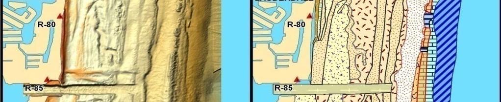
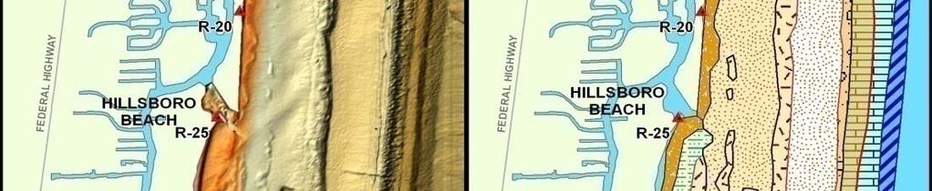
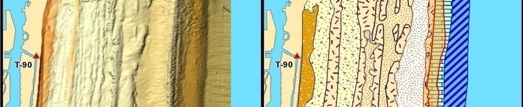
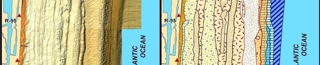
17 STUDY AREA FOR EPU CABLE ROUTES Southeast Florida Atlantic Continental Shelf LADS SURVEY AREA PROVIDES DETAILED INFORMATION ON SEAFLOOR BATHYMETRY The LADS survey area covers about 600 km 2 in state waters along Palm Beach, Broward, and Miami-Dade counties. At its narrowest point, the continental shelf is about 2300 m wide off of Port Everglades.
18 Southeast Florida Atlantic Shelf Grand Bahama Upper Slope Biscayne Bay Shelf Break


 Sand")
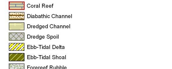
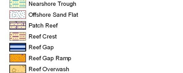
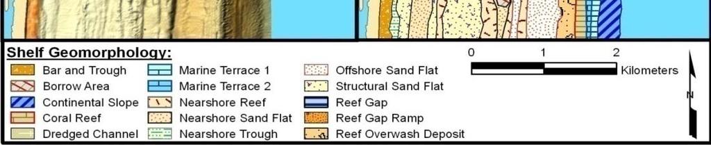
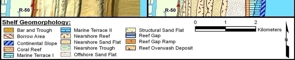
19 LEGEND FOR SE FLORIDA ATLANTIC CONTINENTAL SHELF About 42 geomorphological mapping units grouped by Continental Slope Coral Reef (Florida Reef Tract) Hardbottom (Bedrock exposure) Sand Bottom Forms Tidal Features Applied to LADS imagery


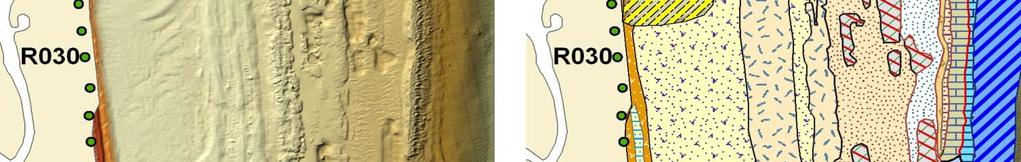
20 RAW DATA COLOR RAMPED GEOMORPHOLOGICAL INTERPRETATION
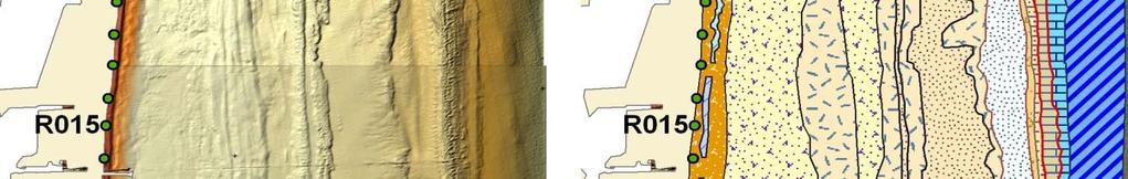
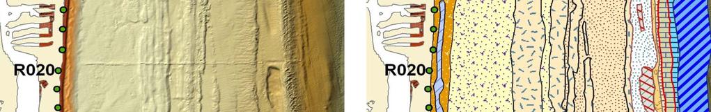
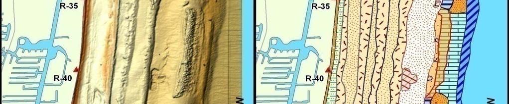
21 LADS MAPPING PROCEDURE Window showing correspondence of mapping units with LADS imagery (bathymetry). Dredge Spoil Beach Ridges Sand Flat Diabathic Channels Sand Flat Sand Flat End of Drowned Beach Ridge g Plain Bahamas Fracture Zone B i i Beginning off Florida Reef Tract


22 HOW DO WE BRING AN ELECTRICAL TRANSMISSION LINE ASHORE? Example of how a surface cable might be laid across the shelf from an EPU farm in the Straits of Florida. Note that the cable enters the shelf through a reef gap and then follows an inter-reefal reefal sand flat, goes through another reef gap, then goes to Port Everglades via the navigation channel, and then to land. This example poses the fewest environmental hazards but creates other problems. Finkl, C.W., Leaky valves in littoral sediment budgets: Loss of nearshore sand to deep offshore zones via chutes in barrier reef systems, southeast coast of Florida, USA. Journal of Coastal Research,, 20(2),


23
24 THE PROBLEM WITH SURFACE ROUTES ON TOP OF THE SEAFLOOR There is no direct route from the EPU farm to the shore The cable route must pass through a reef gap Reef gaps do not line up between reef tracts Reef gaps do not line up with with breaks in hard grounds Cables laid on sand flats compromise future other uses of the sand resource, for beach renourishment for example The solution? Go underground with directional drilling UNDER the coral reefs and hard grounds


25 DIRECTIONAL DRILLING UNDER FLORIDA REEF TRACT From land under the continental shelf and out to sea on the slope From sea under the continental shelf and onto the land Conventional wire-line method and conventional equipment are used without modification. Fixing the direction of drilling can be done easily by electronic ec c multishot survey devices.


26 Southeast Florida Atlantic Shelf Grand Bahama Upper Slope Transmission Line Biscayne Bay Shelf Break Example of a transmission route from the Straits of Florida to land

 can cause sedimentation ti on the coral reef surface smothering reef")
27 DRILLING THROUGH LIMESTONE POSES POTENTIAL PROBLEMS Limestones are typically vuggy Holes and cavities in limestones may reach the surface of the coral reef Leakage of drilling fluids (lubricants and additives), muds (e.g. bentonite clay) can cause sedimentation ti on the coral reef surface smothering reef communities Solution holes Cavity connection with surface Cavities
28 IMPACTS OF DRILLING FLUIDS ON CORAL REEFS The skeletal extension and corallite shape of individuals id of the Caribbean and Atlantic ti reefbuilding coral Montastrea annularis (Ellis and Solander) were measured after more than six weeks' continuous flow-through exposure in laboratory aquaria to treatments t t of 0, 1, 10 and 100-ppm (l 1-1 ) drilling mud. Linear increase of the skeleton (extension rate) and fossa length were significantly depressed in the 100-ppm treatment. t t Chronic exposure to 100-ppm drilling mud impairs coral skeletal growth rate and possibly interferes with sediment rejection capability by lowering calical relief. Dodge, R.E., Marine Biology, 71(2),


29 EPA reports potential adverse impacts of drilling fluids and muds on coral reefs. But, presence of drilling muds must be present in concentrations ti greater than 100 ppm for four weeks or longer to damage coral reefs. There is potential for environmental damage to coral reefs from leakage of drilling fluids and muds, but waves and currents would tend to diminish possible impacts along the FRT.
30 CONCLUSIONS The future presence of EPUs in the Straits of Florida is a possibility The the SE Florida conurbation needs Blue Energy (Ocean Power Getting electrical transmission lines ashore poses environmental problems Geomorphological maps of the seafloor on the continental shelf will help determine the least damaging cable routes Cable approach routes will have to come ashore: (1) On the surface of the seafloor through Reef Gaps or Reef Gap Ramps (2) In Inter-reefalreefal sand flats and thence through hardgrounds (3) Underneath the FRT via directional drilling from land to the continental slope below the Shelf Break where shelf-edge edge coral reefs occur or (4) From directional drilling offshore through the face of the upper continental slope going under the FRT and outcropping on land
31 THANK YOU FOR YOUR ATTENTION
Regional-scale understanding of the geologic character and sand resources of the Atlantic inner continental shelf, Maine to Virginia
 Regional-scale understanding of the geologic character and sand resources of the Atlantic inner continental shelf, Maine to Virginia Workshop on Dredging, Beach Nourishment and Bird Conservation Atlantic
SW Florida Escarpment Mapping Area
 Overview NOAA s Okeanos Explorer (EX) Program plans to conduct systematic mapping and telepresence-enabled ROV explorations in the Gulf of Mexico during Spring 2014. In 2011, the EX conducted mapping operations
Sea Level Rise in Miami-Dade County Florida Implications for Management of Coastal Wetlands and the Everglades
 Sea Level Rise in Miami-Dade County Florida Implications for Management of Coastal Wetlands and the Everglades Peter W. Harlem Dr. John F. Meeder Florida International University Southeast Environmental
Developed in Consultation with Florida Educators
 Developed in Consultation with Florida Educators Table of Contents Next Generation Sunshine State Standards Correlation Chart... 7 Benchmarks Chapter 1 The Practice of Science...................... 11
Sea-level Rise on Cape Cod: How Vulnerable Are We? Rob Thieler U.S. Geological Survey Woods Hole, MA
 Sea-level Rise on Cape Cod: How Vulnerable Are We? Rob Thieler U.S. Geological Survey Woods Hole, MA Outline Sea-level and coastal processes Past sea-level change Predictions for the future Coastal responses
The Coast: Beaches and Shoreline Processes Trujillo & Thurman, Chapter 10
 The Coast: es and Shoreline Processes Trujillo & Thurman, Chapter 10 Oceanography 101 Chapter Objectives Recognize the various landforms characteristic of beaches and coastal regions. Identify seasonal
Marine Spatial Data for Marine Spatial Planning. Ocean Leadership 2010 Public Policy Forum
 Marine Spatial Data for Marine Spatial Planning Ocean Leadership 2010 Public Policy Forum March 10, 2010 Edward Saade President, Fugro EarthData, Inc 1 Marine Spatial Data What is Marine Spatial Data?
Introduction: The Gulf of Mexico Alliance. The Gulf GAME project MERMAid and PHINS Results & Conclusions What s next? Examples
 AAG Las Vegas March 25, 2009 Introduction: Ocean governance and Ecosystem-Based Management The Gulf of Mexico Alliance Habitat Identification and Characterization The Gulf GAME project MERMAid and PHINS
The Coast: Beaches and Shoreline Processes
 1 2 3 4 5 6 7 8 9 The Coast: es and Shoreline Processes Trujillo & Thurman, Chapter 10 Oceanography 101 Chapter Objectives Recognize the various landforms characteristic of beaches and coastal regions.
Small area of the ocean that is partially surrounded by land. The Ocean Basins. Three Major Oceans. Three Major Oceans. What is a SEA?
 The Ocean Basins How Deep is the Ocean? 1 2 Three Major Oceans Three Major Oceans Pacific Atlantic the shallowest ocean (3.3km average depth) Indian second shallowest ocean (3.8km average depth) Pacific
Assessing, Monitoring, and Defending Coral Reefs with GIS
 Assessing, Monitoring, and Defending Coral Reefs with GIS Dr. Rich Snow and Dr. Mary Snow Applied Aviation Sciences Embry-Riddle Aeronautical University Daytona Beach, Florida It is estimated that 60%
June 2018 Sediments and Dredging at GBR Ports
 June 2018 Sediments and Dredging at GBR Ports Reef 2050 Long Term Sustainability Plan The Great Barrier Reef is over 2000 km long and covers an area of approximately 350,000 square kilometres. It is a
Oil & Gas. From exploration to distribution. Week 1 V05 Origin of hydrocarbon resources part 1. Jean-Pierre Deflandre
 Oil & Gas From exploration to distribution Week 1 V05 Origin of hydrocarbon resources part 1 Jean-Pierre Deflandre W1V5 Origin of hydrocarbon resources1 p. 1 Introduction to hydrocarbon resources You will
ARTIFICIAL REEFS FOR MITIGATION
 ARTIFICIAL REEFS FOR MITIGATION A Brief Summary Pat Quinn Environmental Planning and Community Resilience Division Types of Damage to Coral Reefs Anchor damage Beach nourishment Pipelines and cable Vessel
Name Class Date. The ocean floor has varied and distinct surfaces much like those found on land.
 6 Explore the Seafloor BigIdeas The ocean floor has varied and distinct surfaces much like those found on land. Satellites orbiting Earth, as well as sonar technology, are used to map the seafloor. The
Fish and Fish Habitat Follow-up Program. Scotian Basin Exploration Project
 Fish and Fish Habitat Follow-up Program Scotian Basin Exploration Project April 2018 Contents 1 Introduction... 1 2 Scope... 1 3 EIS Commitments and Predictions... 2 4 Methodology and Reporting... 2 4.1
Chapter 1 Study Guide
 Chapter 1 Study Guide Reminders: Vocabulary quiz and test will be on Tuesday, September 6th. Complete study guide and bring completed to school Friday, September 2nd. You are NOT required to print the
Marine Ecology Pacing Guide
 Marine Ecology Pacing Guide Course Description: The focus of the course is the interrelationships among marine organisms and the physical, chemical, geological and biological factors. North Carolina coastal
Draft for Discussion 11/11/2016
 Coastal Risk Consulting (CRC) Climate Vulnerability Assessment for Village of Key Biscayne Deliverable 1.1 in Statement of Work. Preliminary Vulnerability Assessment Identifying Flood Hotspots Introduction...
Hurricane Wilma Post Storm Data Acquisition Estimated Peak Wind Analysis and Storm Tide Data. December 27, 2005
 Hurricane Wilma Post Storm Data Acquisition Estimated Peak Wind Analysis and Storm Tide Data December 27, 2005 Hurricane Wilma was the sixth major hurricane of the record-breaking 2005 Atlantic hurricane
From seafloor geomorphology to predictive habitat mapping: progress in applications of biophysical data to ocean management.
 From seafloor geomorphology to predictive habitat mapping: progress in applications of biophysical data to ocean management. Peter T. Harris Geoscience Australia, Canberra ACT, Australia Currently seconded
Beach Nourishment on the Florida East Coast. Boca Raton
 Beach Nourishment on the Florida East Coast Past Future Boca Raton Erosion is the Main Reason for Beach Past - Erosion on the east coast was mainly caused by inlets created or modified for navigation Nourishment
Coastal and Marine Ecological Classification Standard (CMECS)
") Coastal and Marine Ecological Classification Standard (CMECS) Mark Finkbeiner NOAA Coastal Services Center Presented at the International Workshop on Seabed Mapping Methods and Technology 18 October 2012
Coastal and Marine Ecological Classification Standard (CMECS) Mark Finkbeiner NOAA Coastal Services Center Presented at the International Workshop on Seabed Mapping Methods and Technology 18 October 2012
Earth / Environmental Science. Ch. 14 THE OCEAN FLOOR
 Earth / Environmental Science Ch. 14 THE OCEAN FLOOR The Blue Planet Nearly 70% of the Earth s surface is covered by the global ocean It was not until the 1800s that the ocean became an important focus
Bob Ferguson ATTORNEY GENERAL OF WASHINGTON Washington Street SE PO Box Olympia, WA
 Bob Ferguson ATTORNEY GENERAL OF WASHINGTON 1125 Washington Street SE PO Box 40100 Olympia, WA 98504-0100 The Honorable Ryan Zinke Secretary of the Interior Dr. Walter Cruickshank Acting Director Bureau
Earth Science Lesson Plan Quarter 2, Week 10, Day 1
 Earth Science Lesson Plan Quarter 2, Week 10, Day 1 Outcomes for Today Standard Focus: PREPARE 1. Background knowledge necessary for today s reading. Beaches are created by the actions of waves, tides,
Marine Spatial Planning: A Tool for Implementing Ecosystem-Based Management
 Marine Spatial Planning: A Tool for Implementing Ecosystem-Based Management Steven Murawski, Ph.D., Ecosystem Goal Team Lead National Oceanic and Atmospheric Administration NOAA November 16, 2009 1 To
Sri Lanka has a coastline of km excluding the shoreline of bays and inlets.
 Defining and Demarcating Coastal zones in Sri Lanka Procedure, Challenges and What needs to be done? Dr. Anil Premaratne Director General Coast Conservation Coast Conservation Department Sri Lanka 1 Sri
Form 4 of Schedule 5 of the Exclusive Economic Zone and Continental Shelf (Environmental Effects Permitted Activities) Regulations 2013
 Regulations 2013") FORM 4 Permitted activities: Post-activity report Form 4 of Schedule 5 of the Exclusive Economic Zone and Continental Shelf (Environmental Effects Permitted Activities) Regulations 2013 How to use this
FORM 4 Permitted activities: Post-activity report Form 4 of Schedule 5 of the Exclusive Economic Zone and Continental Shelf (Environmental Effects Permitted Activities) Regulations 2013 How to use this
The Marine Environment
 The Marine Environment SECTION 16.1 Shoreline Features In your textbook, read about erosional landforms, beaches, estuaries, longshore currents, and rip currents. For each statement below, write or. 1.
ALASKA DEEP-DRAFT ARCTIC PORT EVALUATION
 ALASKA DEEP-DRAFT ARCTIC PORT EVALUATION Joint Study of Federal and State June 20, 2012 Opportunity and Constraint Warming of Arctic region is leading to new maritime opportunities. Thawing of permafrost
Last Time. Submarine Canyons and Fans. Turbidites. MAS 603: Geological Oceanography. Lecture 16: Greenhouse vs. Icehouse Earths
 UNIVERSITY OF SOUTH ALABAMA Last Time MAS 603: Geological Oceanography Lecture 16: Greenhouse vs. Icehouse Earths Submarine Fans Definition and morphology Transport mechanisms (density currents) Submarine
Formation Stratigraphy and Interfingering at the Port of Miami
 Formation Stratigraphy and Interfingering at the Port of Miami AUGUST 6, 2012 PROJECT PARTNERS Public Sponsors 90% Equity Partner Contractor 10% Equity Partner VMS Operator Federal Support FUNDING PARTNERS
Submersible investigation of unconfirmed western Miami Terrace habitat
 Submersible investigation of unconfirmed western Miami Terrace habitat Prepared By: Brian K. Walker, Ph.D. Nova Southeastern University Oceanographic Center 6/08/2015 On June 5, 2015 Nova Southeastern
MEMORANDUM FOR SWG
 MEMORANDUM FOR SWG-2007-1623 Subject: Jurisdictional Determination (JD) for SWG-2007-1623 on Interdunal Wetlands Adjacent to Traditional Navigable Waters (TNWs) Summary The U.S. Environmental Protection
Geophysics the use of geology, laboratory & field experiments, mathematics, and instruments to study: Earthquakes and Volcanoes seismometers,
 Geophysics the use of geology, laboratory & field experiments, mathematics, and instruments to study: Earthquakes and Volcanoes seismometers, tiltmeters, EDM, remote sensing, Energy: oil, gas, hydrothermal
Natura 2000 in the marine environment: state of implementation and next steps
 Life on the blue planet: biodiversity research and the new European marine policies EPBRS European Platform on Biodiversity Research Strategy Porto, Portugal 7-9 November 2007 Natura 2000 in the marine
MISSISSIPPI COASTAL IMPROVEMENTS
 MISSISSIPPI COASTAL IMPROVEMENTS PROGRAM (MsCIP) Comprehensive Barrier 237 27 200 237 27 200 Island 237 Restoration 27 200 Plan 80 9 27 252 74.59 255 255 255 0 0 0 63 63 63 3 32 22 239 65 53 0 35 20 2
Environmental impact assessment study of the new offshore dumping sites for Šventoji port in Lithuania
 Environmental impact assessment study of the new offshore dumping sites for Šventoji port in Lithuania Introduction Summary In 2003 Lithuanian Ministry of Transport initiated the preparation of feasibility
Lecture 26: Marine Geology Read: Chapter 21 Homework due December 3
 Learning Objectives (LO) Lecture 26: Marine Geology Read: Chapter 21 Homework due December 3 What we ll learn today:! 1. Describe the world s five oceans! 2. Understand patterns of ocean circulation! 3.
ERDC Update SAD Regional Management Board
 ERDC Update SAD Regional Management Board José E. Sanchez, P.E., SES Director, Coastal and Hydraulics Laboratory Engineer Research and Development Center 14FEB17 Overview of R&D Activities in AOR Cross
GY 402: Sedimentary Petrology
 UNIVERSITY OF SOUTH ALABAMA GY 402: Sedimentary Petrology Lecture 22: Reefs Instructor: Dr. Douglas W. Haywick Last Time Shelves Definition and a bit of history Factors controlling shelf sedimentation
Introduction to Acoustic Remote Sensing and Seafloor Mapping (AE4-E13) May 19, 2010
 May 19, 2010") Introduction to Acoustic Remote Sensing and Seafloor Mapping (AE4-E13) May 19, 2010 1 Delft Vermelding Institute onderdeel of Earth organisatie Observation and Space Systems Why Acoustic Remote Sensing?
Introduction to Acoustic Remote Sensing and Seafloor Mapping (AE4-E13) May 19, 2010 1 Delft Vermelding Institute onderdeel of Earth organisatie Observation and Space Systems Why Acoustic Remote Sensing?
SEMESTER AT SEA COURSE SYLLABUS. Introduction to Oceanography
 COURSE DESCRIPTION SEMESTER AT SEA COURSE SYLLABUS Introduction to Oceanography More of an exploration of the seas than a class, this course engages students in direct observation, reflection, and analysis.
Alexandra Carvalho, Ph.D., GISP Kathy Fitzpatrick, P.E.
 Coastal Data Organization for Project Management and Coastal Planning Martin County, Florida Alexandra Carvalho, Ph.D., GISP Kathy Fitzpatrick, P.E. Outline County Coastal Programs Coastal Geodatabase
BOEM Marine Minerals Program
 BOEM Marine Minerals Program Restoring and Protecting Our Nation s Coasts through Stewardship of OCS Sand Resources SECOORA 2018 Annual Meeting May 22-24 Doug Piatkowski Douglas.piatkowski@boem.gov 703-787-1833
Planning for the Future of Humboldt Bay: Sea Level Rise, Sediment Management, Sand Spits and Salt Marshes. Joel Gerwein
 Planning for the Future of Humboldt Bay: Sea Level Rise, Sediment Management, Sand Spits and Salt Marshes Joel Gerwein Introduction to Humboldt Bay Setting Economy, community, and environment Sediment
Sister Sanctuaries: Linking the Science and Management of Coral Reefs in Cuba and the U.S.
 Sister Sanctuaries: Linking the Science and Management of Coral Reefs in Cuba and the U.S. Memorandum of Understanding on Cooperation in the Conservation and Management of Marine Protected Areas Seventh
Unit 4 - Water. Earth s Interior. Earth s Interior. Continental Drift. Continental Drift. Continental Drift. Crust. Mantle. Core.
 Unit 4 - Water How did the oceans form? What special adaptations do saltwater organisms have? Where does our water come from? How do humans affect the Earth s water? Crust Rigid outer shell of Earth Oceanic
Bob Van Dolah. Marine Resources Research Institute South Carolina Department of Natural Resources
 Bob Van Dolah Marine Resources Research Institute South Carolina Department of Natural Resources Shoreline Change Will Occur! On our front beaches where it is not easy to retreat Shoreline Change Will
ARE YOU READY TO THINK? Look at the first slide THINK PAIR SHARE!
 ARE YOU READY TO THINK? Look at the first slide THINK PAIR SHARE! WHAT PROMINENT FEATURE CAN YOU IDENTIFY IN THIS PICTURE? What do you think the different colors represent? Who might find such a picture
CLT/HER/CHP/OG 1- page 29
 CLT/HER/CHP/OG 1- page 29 MODEL INVENTORY SHEET FOR UNDERWATER CULTURAL HERITAGE COUNTRY REGION, PROVINCE COMPETENT AUTHORITY REGISTERED BY (name, position) Date Email / Tel nº SITE NAME (provide also
GEOLOGY MEDIA SUITE Chapter 5
 UNDERSTANDING EARTH, SIXTH EDITION GROTZINGER JORDAN GEOLOGY MEDIA SUITE Chapter 5 Sedimentation Rocks Formed by Surface Processes 2010 W.H. Freeman and Company Mineralogy of sandstones Key Figure 5.12
Mark H. Horwitz Ping Wang PhD Coastal Research Laboratory, School of Geosciences University of South Florida
 Mark H. Horwitz Ping Wang PhD Coastal Research Laboratory, School of Geosciences University of South Florida American Shore & Beach Preservation Association 2015 National Coastal Conference, New Orleans,
Natural Disasters. in Florida. Severe Thunderstorms
 Natural Disasters in Florida SC.6.E.7.7 Investigate how natural disasters have affected human life in Florida. Severe Thunderstorms While the typical afternoon thunderstorm in Florida may not appear to
 http://www.neic.cr.usgs.gov/neis/pands/global.html Global Seismicity and World Cities This map displays the worldwide hazard to cities by large earthquakes. When earthquakes occur near cities, the potential
Tony Pratt, DNREC to The Center for the Inland Bays Scientific and Technical Advisory Committee. August 21, 2009
 Sea Level Rise in Delaware Presented by Tony Pratt, DNREC to The Center for the Inland Bays Scientific and Technical Advisory Committee August 21, 2009 Sea level has been fluctuating ever since there have
Marine Geomorphology as a Determinant for Essential Life Habitat III
 Marine Geomorphology as a Determinant for Essential Life Habitat III marinecoastalgis.net/aag08 10:10 Dawn Wright, Oregon 10:30 Will McClintock, California 10:50 Daniel Sampson, Massachusetts 11:10 Gary
Relatively little hard substrate occurs naturally in the
 CHAPTER FIVE Rock Habitats Relatively little hard substrate occurs naturally in the estuary, owing mainly to the vast quantities of fine sediment that have been deposited by the rivers. Rock habitat is
Unit 1: Water Systems on Earth Chapter 2
 Unit 1: Water Systems on Earth Chapter 2 Create a mind map with the driving question, Why are Oceans Important? Remember: Why are oceans so important? Why are oceans so important? Primary water source
Biogeographic Approach to Coastal Assessments & Spatial Planning
 NOAA s Biogeographic Approach to Coastal Assessments & Spatial Planning Mark E. Monaco Mark.Monaco@noaa.gov Center for Coastal Monitoring and Assessment http://ccma.nos.noaa.gov/about/biogeography Biogeography
Science and Policy Considerations for Coastal and Marine Spatial Planning in the Wider Caribbean. John Ogden, University of South Florida
 Science and Policy Considerations for Coastal and Marine Spatial Planning in the Wider Caribbean John Ogden, University of South Florida The Caribbean is Ecologically and Politically Complex The Caribbean
Overview of Engineering. Risk Management for Successful Wind Energy Development, Offshore U.S.
 Overview of Engineering Considerations for Siting and Risk Management for Successful Wind Energy Development, Offshore U.S. Bi Briefing for: North Carolina Offshore Wind Task Force Tom McNeilan, P.E. General
Habitat Mapping in The Hauraki Gulf Marine Park. Dan Breen
 Habitat Mapping in The Hauraki Gulf Marine Park Dan Breen Outline 1. Intro Habitat mapping 2. Coastal marine habitats and marine protected areas in the New Zealand Territorial Sea: a broad scale gap analysis
Marine ecosystem mapping at the Prince Edward Islands
 Marine ecosystem mapping at the Prince Edward Islands Biodiversity Planning Forum NBA special session June 2018 R Adams, C von der Meden, A Dayaram, K Sink, A Lombard, A Bosman, M Dopolo, F Fourie, L Harris,
South Carolina Coastal Habitats
 South Carolina Coastal Habitats By C. Livingston, 2009 Earth Where is South Carolina? North America United States of America SC Here we are! South Carolina borders the Atlantic Ocean. Did you know? South
OCEANOGRAPHY CURRICULUM. Unit 1: Introduction to Oceanography
 Chariho Regional School District - Science Curriculum September, 2016 OCEANOGRAPHY CURRICULUM Unit 1: Introduction to Oceanography OVERVIEW Summary In this unit students will be introduced to the field
The Niagara Escarpment extends from western New York, through the GTA all the way up to Manitoulin Island and into Michigan and Wisconsin.
 is southern Ontario s most prominent topographic feature, extending more than 500 kilometres from western New York, through Niagara Falls and the western part of the Greater Toronto Area (GTA), and north
Physiography Ocean Provinces p. 1 Dimensions p. 1 Physiographic Provinces p. 2 Continental Margin Province p. 2 Deep-Ocean Basin Province p.
 Physiography Ocean Provinces p. 1 Dimensions p. 1 Physiographic Provinces p. 2 Continental Margin Province p. 2 Deep-Ocean Basin Province p. 2 Mid-Ocean Ridge Province p. 3 Benthic and Pelagic Provinces
Coastal and Marine Ecological Classification Standard (CMECS)
") Coastal and Marine Ecological Classification Standard (CMECS) Kathy Goodin, NatureServe EMECS, August 2011 Baltimore, MD 1 Outline Objectives & Process Classification Content Questions 2 Objectives Develop
Coastal and Marine Ecological Classification Standard (CMECS) Kathy Goodin, NatureServe EMECS, August 2011 Baltimore, MD 1 Outline Objectives & Process Classification Content Questions 2 Objectives Develop
4. In areas where tectonic plates collide, the seafloor has deep. 5. In areas where tectonic plates separate, the seafloor has mid- ocean
 Name Date Hour Table Chapter 14 Lesson One- General Directions: Use the word bank below to complete each statement. NOT all terms are used. abyssal plains brackish water condensation energy freshwater
Coastal issues: Beaches and Estuaries
 Coastal issues: Beaches and Estuaries Definitions: Coast = broad zone where both marine & terrestrial processes act It includes the beach, lagoons, marshes, bars etc. Coastal processes act to shape the
Geol 117 Lecture 18 Beaches & Coastlines. I. Types of Coastlines A. Definition:
 I. Types of Coastlines A. Definition: 1. Shore = narrow zone where ocean meets land (e.g. beach) 2. Coast is a broad area where both ocean and land processes act a. Includes onshore marshes, dunes, sea
NOAA S Arctic Program in 2017
 NOAA S Arctic Program in 2017 NOAA s Arctic Mission To determine how the Arctic system is changing on time scales of weeks to decades, particularly with respect to the consequences that the loss of sea
The Marine Environment
 The Marine Environment SECTION 16.1 Shoreline Features In your textbook, read about erosional landforms, beaches, estuaries, longshore currents, and rip currents. For each statement below, write true or
Table of Contents. Introduction 4. Chapter 1 Research and the Deep Oceans 6. Chapter 2 Physical Characteristics of the Ocean 10
 Table of Contents Introduction 4 Chapter 1 Research and the Deep Oceans 6 Chapter 2 Physical Characteristics of the Ocean 10 Chapter 3 Composition of the Oceans Waters 16 Chapter 4 Tides, Waves, and Currents
Modeling habitat suitability for the European green crab using the ShoreZone mapping system
 Modeling habitat suitability for the European green crab using the ShoreZone mapping system Jodi N. Harney, Ph.D. and John R. Harper, Ph.D. Coastal and Ocean Resources Inc. Mary Morris, R.P. Bio. Archipelago
GO ON. Directions: Use the diagram below to answer question 1.
 d i a g n o s t i c t e s t : e a r t h a n d s p a c e s c i e n c e question 1. 1. What is the correct order (starting from the surface) of Earth s layers? A crust, outer core, inner core, mantle B mantle,
In 1990, 50% of the U.S. population lived within 75 km of a coast. By 2010, 75% of the U.S. population will live within 75 km of a coast.
 In 1990, 50% of the U.S. population lived within 75 km of a coast. By 2010, 75% of the U.S. population will live within 75 km of a coast. High Tech Methods for Surveying the Deep Sea Floor Fig. 20.18 1
SHORELINE AND BEACH PROCESSES: PART 2. Implications for Coastal Engineering
 SHORELINE AND BEACH PROCESSES: PART 2 Implications for Coastal Engineering Objectives of the lecture: Part 2 Show examples of coastal engineering Discuss the practical difficulties of ocean engineering
Earth has one big ocean with many features.
 1 The Earth has one big ocean with many features. A The ocean is the defining physical feature on our planet Earth covering approximately 70% of the planet s surface. There is one ocean with many ocean
Advancing Real Time Observations and Coastal Modeling Forecasts-
 Advancing Real Time Observations and Coastal Modeling Forecasts- Moving Forward in a Changing Coastal Landscape Next Generation Navigation-Coastal Operations- Coastal and Nearshore Coastal Operational
Bay Drift. An activity for middle or high school students on ocean currents, marine debris, and citizen science, created by CARTHE
 Bay Drift An activity for middle or high school students on ocean currents, marine debris, and citizen science, created by CARTHE (Part of the Ocean Currents & Oil Spills STEAM Lessons by CARTHE and Piano
Introduction After reviewing the classification of continental margins (not plate margins) in your textbook, answer the following questions:
 in your textbook, answer the following questions:") Investigating the continental margins of North America using GeoMapApp. This exercise is designed to familiarize you with the features of continental margins. Through the analysis of color-coded bathymetric
Investigating the continental margins of North America using GeoMapApp. This exercise is designed to familiarize you with the features of continental margins. Through the analysis of color-coded bathymetric
Marine Sediments. Introductory Oceanography. Ray Rector: Instructor
 Marine Sediments Introductory Oceanography Ray Rector: Instructor Ocean Basins are Vast Sinks for Huge Amounts of Sediment from Numerous Different Sources Four Major Types of Seafloor Sediments 1. Lithogenous
The Sea Floor. Chapter 2
 The Sea Floor Chapter 2 Geography of the Ocean Basins World ocean is the predominant feature on the Earth in total area Northern Hemisphere = 61% of the total area is ocean. Southern Hemisphere = about
Objectives: Describe the structure of the ocean floor. Describe light intensity and temperature characteristics at different ocean depths.
 Ocean Structure Virtual Lab What are some characteristics of the ocean and the ocean floor? Earths highest mountains, deepest valleys, and flattest plains are found not on land but under the ocean. Beyond
Seas. A sea is a part of an ocean that is nearly surrounded by water. The Mediterranean, Arctic and Black Sea are really part of the Atlantic Ocean.
 Exploring the Ocean Since ancient times people have studied the ocean such as waters and ocean floor It provides food and services, and serves as a route for trade and travel The World s Oceans 71% of
Designing Networks of Marine Protected Areas in DFO s Three Atlantic Bioregions
 Designing Networks of Marine Protected Areas in DFO s Three Atlantic Bioregions Presentation for Indigenous Protected Areas Workshop Max Westhead, DFO and Adrian Gerhartz-Abraham, Dalhousie March 29, 2017
Contents. Preface. IC. Introductory Chapter. 1. The Ocean in the Earth System. Ocean Studies and Pedagogy Acknowledgments
 Contents Preface Ocean Studies and Pedagogy Acknowledgments IC. Introductory Chapter IC.1 Why the Ocean is Important to Us? IC.1.1 Biological Resources IC.1.1.1 Fisheries IC.1.1.2 Other Biological Resources
Changes in Ecosystems - Natural Events
 Changes in Ecosystems - Natural Events 8A predict and describe how different types of catastrophic events impact ecosystems such as floods, hurricanes, or tornadoes Textbook pages: 396-406 How can ecosystems
Marine Spatial Planning Leslie-Ann McGee Battelle Memorial Institute
 Marine Spatial Planning Leslie-Ann McGee Battelle Memorial Institute Rev061708 1 Marine Spatial Planning What is it? Why is it different? Where is it currently being employed? What is happening in the
Sediment Management in the Coastal Bays
 Sediment Management in the Coastal Bays Introduction Need for ecosystem view of sediment management in Coastal Bays Island loss and restoration Navigation needs Habitat Trade offs Living Shoreline Requirements
International Guidelines for Ecosystem-based, Marine Spatial Management
 International Guidelines for Ecosystem-based, Marine Spatial Management Charles Ehler and Fanny Douvere, Consultants Intergovernmental Oceanographic Commission and Man and the Biosphere Programme UNESCO
Status of Big Bend oyster populations The view from deep history
 Status of Big Bend oyster populations The view from deep history Greg Herbert School of Geosciences Stephen Hesterberg Integrative Biology Thomas Pluckhahn Department of Anthropology http://myfwc.com/media/4242314/chimmp2017-chapter01-introduction.pdf
Spatial Planning in Canada s Maritimes Region. Maritimes Region
 Spatial Planning in Canada s Maritimes Region Glen Herbert, Scott Coffen-Smout Smout,, and Tanya Koropatnick Oceans and Coastal Management Division Ecosystem Management Branch Fisheries and Oceans Canada
OSU Ocean Observing Center
 OSU Ocean Observing Center and The Ocean Observatories Initiative OSU Retirement Association March 10,19 2016 2 Early Ocean Observations OSU Retirement Association March 10,19 2016 3 No information off
UNIT 1: WATER SYSTEMS ON EARTH CHAPTER 2: OCEANS CONTROL THE WATER CYCLE
 UNIT 1: WATER SYSTEMS ON EARTH CHAPTER 2: OCEANS CONTROL THE WATER CYCLE ORIGINS OF OCEAN WATER OCEANS HAVE FILLED OVER HUNDREDS OF MILLIONS OF YEARS SCIENTISTS BELIEVE THE OCEANS ARE MORE THAN 3 BILLION
Marine environment monitoring : The basic requirements to support Marine Renewable Energies
 Marine environment monitoring : The basic requirements to support Marine Renewable Energies SHOM in brief SHOM is the French Government agency in charge of Hydrography and Oceanography SHOM s vocation
Bureau of Economic and Business Research May 29, Measuring Population Density for Counties in Florida
 Bureau of Economic and Business Research May 29, 2015 Measuring Population Density for Counties in Florida By: Stefan Rayer, PhD; Ying Wang, PhD https://www.bebr.ufl.edu/content/measuring-population-density-counties-florida