Status of Big Bend oyster populations The view from deep history
|
|
|
- Camilla Lester
- 5 years ago
- Views:
Transcription


1 Status of Big Bend oyster populations The view from deep history Greg Herbert School of Geosciences Stephen Hesterberg Integrative Biology Thomas Pluckhahn Department of Anthropology

2

3 Florida s Big Bend coastline (Gulf of Mexico coast from Crystal River to Apalachee Bay) supports large expanses of oyster reef habitat that have existed for thousands of years in a region that is one of the most pristine coastal zones in the continental US. Seavey, J.R., et al., Decadal changes in oyster reefs in the Big Bend of Florida's Gulf Coast. Ecosphere, 2:1-14
4 It is worth noting that not all estuaries have suffered decline in either oyster extent or biomass since our approximate 1900 baseline; two estuaries (Apalachicola Bay, FL; Sabine Lake, TX and LA) showed stable or even increasing extent and biomass on oyster grounds. Zu Ermgassen, P.S. et al., Historical ecology with real numbers: past and present extent and biomass of an imperilled estuarine habitat. Proc. R. Soc. B, 279(1742), pp In contrast to the situation on the Atlantic Coast, it is noteworthy that for Apalachicola Bay in the Gulf of Mexico, we estimate present day levels of filtration that are greater than historic estimates. Zu Ermgassen, P.S., et al., Quantifying the loss of a marine ecosystem service: filtration by the eastern oyster in US estuaries. Estuaries and coasts, 36(1), pp

5 Extensive aquatic preserves Minimal human development
6

7 Kirby, M.X., Fishing down the coast: historical expansion and collapse of oyster fisheries along continental margins. Proceedings of the National Academy of Sciences of the United States of America, 101(35), pp
8 Long-term degradation During our study period (1982 to 2011), we found a 66% net loss of oyster reef area ( ha) with losses concentrated on offshore (88%), followed by nearshore (61%), and inshore reefs (50%). Seavey, J.R., et al., Decadal changes in oyster reefs in the Big Bend of Florida's Gulf Coast. Ecosphere, 2:1-14

9 Runaway feedbacks from loss of offshore reefs Oyster reef extent offshore of Withlacoochee and Crystal rivers in the mid-1800s and Map by S. Hesterberg. Data sources: Raabe et al. 2004, SRWMD 2001a.


10 Conservation Paleobiology AIMS: Bring attention to the deep historical roots of human influence on the biosphere Provide alternative models for what a healthy reef looks like DATA: Archaeology Paleontology
11
12

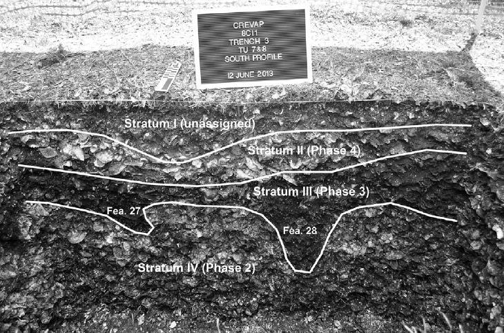
13 Crystal River is one of the largest mound complexes in Florida. Dates to 1000 BC to AD Before at least one-third of it was borrowed away for fill in the 1950s, Mound A was one of the largest mounds in Florida.
 burial complex (C-F) large shell midden")
14 Three platform mounds (A, H, K) burial mound (G) burial complex (C-F) large shell midden (B)

15
16

17 Barnacles Oyster Charcoal Ceramics Bone Crown Conch Limestone Marsh Clam
18 No change in oyster size over 1000 yr of intensive harvest Box and whisker plots show the median (central line), mean (cross), first and third quartiles (box), as well as 1.5 the interquartile range (whiskers). Circles are measurements within 3 the interquartile range of the median.

19
, as well as 1.5 the interquartile range (whiskers).")
20 No change in oyster size today along steep salinity gradient Box and whisker plots show the median (central line), mean (cross), first and third quartiles (box), as well as 1.5 the interquartile range (whiskers). Circles are measurements within 3 the interquartile range of the median.
21 Size decrease Box and whisker plots show the median (central line), mean (cross), first and third quartiles (box), as well as 1.5 the interquartile range (whiskers). Circles are measurements within 3 the interquartile range of the median.

22 Oyster size change at Crystal River, FL mean size modern max size modern mean size midden max size midden
23 Truncated size structure Less habitat and less complex habitat Reduced ecosystem services (filtration) Hesterberg, S.G., et al., Three dimensional interstitial space mediates predator foraging success in different spatial arrangements. Ecology, 98:

24


25 Are modern oysters slower growing or shorter lived?

26 Truncated year-class structure Growth rates and longevity have both declined Older individuals buffer populations from recruitment failure Modern populations have higher proportion of dead shell, dominated by shell destruction vs production dynamics Modern CR oyster Archaeological CR oyster

27 Conclusions The healthiest oyster reefs left are severely degraded relative to natural baselines. Populations exhibit early warning signs of collapse. Can self-sustaining oyster habitat be achieved in populations with reduced generation times? Mann and Powell (2007)
Restored oyster reefs enhance estuarine ecosystem services by altering nearshore salinity
 Restored oyster reefs enhance estuarine ecosystem services by altering nearshore salinity Photo: UF/IFAS David Kaplan, Maitane Olabarrieta, Peter Frederick, and Arnoldo Valle-Levinson Globally: Most Threatened
Preliminary Results from Coordinated Sea-Level Rise Modeling Using SLAMM, the Sea Level Affecting Marshes Model, Across the US Gulf of Mexico Coast
 Preliminary Results from Coordinated Sea-Level Rise Modeling Using SLAMM, the Sea Level Affecting Marshes Model, Across the US Gulf of Mexico Coast James W. Pahl, Ph.D., and Kristin DeMarco, State of Louisiana
Introduction: The Gulf of Mexico Alliance. The Gulf GAME project MERMAid and PHINS Results & Conclusions What s next? Examples
 AAG Las Vegas March 25, 2009 Introduction: Ocean governance and Ecosystem-Based Management The Gulf of Mexico Alliance Habitat Identification and Characterization The Gulf GAME project MERMAid and PHINS
Quantifying effects of oil on coastal dune vegetation. Thomas Miller and Elise Gornish Biological Science, Florida State University
 Quantifying effects of oil on coastal dune vegetation Thomas Miller and Elise Gornish Biological Science, Florida State University Natural History of Barrier Islands in the Northern Gulf Make up ~70% of
Module 3. Basic Ecological Principles
 Module 3. Basic Ecological Principles Ecosystem Components Abiotic Biotic Species & Habitat The Biomes of North America Communities Energy & Matter Cycles in Ecosystems Primary Productivity Simple Ecosystem
U.S. Department of the Interior U.S. Geological Survey. Krista Karstensen Mark Drummond
 USGS Land-Cover Trends: A focus on contemporary land-use and land-cover change within the LCCs U.S. Department of the Interior U.S. Geological Survey Krista Karstensen Mark Drummond The Challenge Land
Hurricanes, Oysters, and Salinity
 Hurricanes, Oysters, and Salinity Materials For the leader: Computer Projector Graphing paper For the activity: Graphing paper or graphing program 2010-11 Oyster Mortality Data Tables 2010-11 Rainfall
Developed in Consultation with Florida Educators
 Developed in Consultation with Florida Educators Table of Contents Next Generation Sunshine State Standards Correlation Chart... 7 Benchmarks Chapter 1 The Practice of Science...................... 11
Spatio-temporal dynamics of Marbled Murrelet hotspots during nesting in nearshore waters along the Washington to California coast
 Western Washington University Western CEDAR Salish Sea Ecosystem Conference 2014 Salish Sea Ecosystem Conference (Seattle, Wash.) May 1st, 10:30 AM - 12:00 PM Spatio-temporal dynamics of Marbled Murrelet
Coastal and Marine Ecological Classification Standard (CMECS)
") Coastal and Marine Ecological Classification Standard (CMECS) Mark Finkbeiner NOAA Coastal Services Center Presented at the International Workshop on Seabed Mapping Methods and Technology 18 October 2012
Coastal and Marine Ecological Classification Standard (CMECS) Mark Finkbeiner NOAA Coastal Services Center Presented at the International Workshop on Seabed Mapping Methods and Technology 18 October 2012
Relatively little hard substrate occurs naturally in the
 CHAPTER FIVE Rock Habitats Relatively little hard substrate occurs naturally in the estuary, owing mainly to the vast quantities of fine sediment that have been deposited by the rivers. Rock habitat is
III. Acropora coral habitat distribution
 2008 Quick Look Report: Miller et al. III. Acropora coral habitat distribution Background The declines in abundance of two of the principal Caribbean reef-building corals, staghorn coral (Acropora cervicornis)
Taxonomy and Systematics: a broader classification system that also shows evolutionary relationships
 Taxonomy: a system for naming living creatures Carrolus Linnaeus (1707-1778) The binomial system: Genus and species e.g., Macrocystis pyrifera (Giant kelp); Medialuna californiensis (halfmoon) Taxonomy
6. What has been the most effective erosive agent in the climate system? a. Water b. Ice c. Wind
 Multiple Choice. 1. Heinrich Events a. Show increased abundance of warm-water species of planktic foraminifera b. Show greater intensity since the last deglaciation c. Show increased accumulation of ice-rafted
Ecological Patterns and Processes in Ghost Tree Islands of the Everglades
 Ecological Patterns and Processes in Ghost Tree Islands of the Everglades Sharon M. L. Ewe 1, Binhe Gu 2, Jennifer Vega 1 and Kristin Vaughan 1 1 Ecology and Environment Inc., 12300 South Shore Blvd, Wellington,
Coastal issues: Beaches and Estuaries
 Coastal issues: Beaches and Estuaries Definitions: Coast = broad zone where both marine & terrestrial processes act It includes the beach, lagoons, marshes, bars etc. Coastal processes act to shape the
Capturing a Holistic Understanding of a Large Marine Ecosystem The NOAA Gulf of Mexico Data Atlas
 Capturing a Holistic Understanding of a Large Marine Ecosystem The NOAA Gulf of Mexico Data Atlas NODC / National Coastal Data Development Center gulfalas.noaa.gov Need: data that contribute to long-term
Oyster Reef for Shoreline Stabilization and Restoration. Jason Kirkpatrick Conservation Program Manager MacDill AFB Tampa, Florida
 Oyster Reef for Shoreline Stabilization and Restoration Jason Kirkpatrick Conservation Program Manager MacDill AFB Tampa, Florida Interbay Penninsula Port of Tampa X The few remaining mangroves are being
Hurricanes & Oysters. Materials For the leader: Computer Projector Graphing paper
 Hurricanes & Oysters Materials For the leader: Computer Projector Graphing paper For the activity: Graphing paper or graphing program 2010-11 Oyster Mortality Data Tables 2010-11 Rainfall & Salinity Figures
Bob Van Dolah. Marine Resources Research Institute South Carolina Department of Natural Resources
 Bob Van Dolah Marine Resources Research Institute South Carolina Department of Natural Resources Shoreline Change Will Occur! On our front beaches where it is not easy to retreat Shoreline Change Will
CLIMAR-III Third JCOMM Workshop on Advances in Marine Climatology 6-9 May Gdynia, Poland
 CLIMAR-III Third JCOMM Workshop on Advances in Marine Climatology 6-9 May 2008. Gdynia, Poland Catherine Marzin Historical Ecology Program Manager National Marine Sanctuary Program Stefan Claesson Research
Climate change, ocean acidification and individual-based models: Why the little things matter
 Climate change, ocean acidification and individual-based models: Why the little things matter Author Richards, Russell, Meynecke, Olaf, Chaloupka, M, Tomlinson, Rodger Benson Published 2012 Conference
Coastal Ecosystems: Salt Marshes and Mangroves. Marine Biology Dr. Ouida Meier
 Coastal Ecosystems: Salt Marshes and Mangroves Marine Biology Dr. Ouida Meier Factors Driving Coastal Ecosystems Latitude temperature light, seasonality Tidal cycles amplitude frequency Wave energy Degree
Sea Level Rise in Miami-Dade County Florida Implications for Management of Coastal Wetlands and the Everglades
 Sea Level Rise in Miami-Dade County Florida Implications for Management of Coastal Wetlands and the Everglades Peter W. Harlem Dr. John F. Meeder Florida International University Southeast Environmental
Storm Surge Analysis Update Meeting Cross City, Florida June 17, 2014
 Big Bend Coastal Storm Surge Study Storm Surge Analysis Update Meeting Cross City, Florida June 17, 2014 Introductions Risk MAP Project Team FEMA Region IV Florida Division of Emergency Management (FDEM)
Coastal and Marine Ecological Classification Standard (CMECS)
") Coastal and Marine Ecological Classification Standard (CMECS) Kathy Goodin, NatureServe EMECS, August 2011 Baltimore, MD 1 Outline Objectives & Process Classification Content Questions 2 Objectives Develop
Coastal and Marine Ecological Classification Standard (CMECS) Kathy Goodin, NatureServe EMECS, August 2011 Baltimore, MD 1 Outline Objectives & Process Classification Content Questions 2 Objectives Develop
Opening their Shells Getting commercial clammers involved in marine spatial planning
 Opening their Shells Getting commercial clammers involved in marine spatial planning Ed Lewandowski Coastal Communities Development Specialist University of Delaware/Delaware Sea Grant Highlights Background
Subtidal permanently flooded with tidal water. Irregularly exposed surface exposed by tides less often than daily
 Types of Wetlands Tidal Systems COASTAL WETLAND ECOSYSTEMS Tidal Salt Marshes Tidal Freshwater Marshes Mangrove Wetlands Tidal Estuarine Wetland 1 Definition and Formation of Estuaries u Estuary : partially
Types of Wetlands. Tidal Systems
 Types of Wetlands Tidal Systems 1 COASTAL WETLAND ECOSYSTEMS Tidal Salt Marshes Tidal Freshwater Marshes Mangrove Wetlands 2 Tidal Estuarine Wetland 3 Definition and Formation of Estuaries Estuary: : partially
Ecosystem History of Florida Bay and the Southern Estuaries Five Year Update. G. Lynn Wingard (USGS)
") Ecosystem History of Florida Bay and the Southern Estuaries Five Year Update G. Lynn Wingard (USGS) Progress since 2003 Florida Bay Science Conference Expansion of Ecosystem History Research into surrounding
Ecosystem History of Florida Bay and the Southern Estuaries Five Year Update G. Lynn Wingard (USGS) Progress since 2003 Florida Bay Science Conference Expansion of Ecosystem History Research into surrounding
Maryland Oyster Stock Assessment Update. December 18, 2017 St. Mary s City, MD
 Maryland Oyster Stock Assessment Update December 18, 2017 St. Mary s City, MD 1 What are the goals of a stock assessment? Stock assessments : 1. Estimate current fish stock status relative to relative
Nathaniel Weston. Department of Geography & the Environment Villanova University 30 January 2013 Delaware Estuary Science & Environmental Summit
 Nathaniel Weston Department of Geography & the Environment Villanova University 30 January 2013 Delaware Estuary Science & Environmental Summit Land Use Change in Colonial Period Through 1900s Soil Erosion
A Comparison of the Social Valuation of Ecosystem Services in Urban and Rural Contexts
 A Comparison of the Social Valuation of Ecosystem Services in Urban and Rural Contexts Jarrod L. Loerzel College of Charleston Zachary D. Cole University of Florida Presentation Map 1. What is SolVES?
Long-Term Patterns of Coastal Response to Changing Land Use and Climate: Examples from the Atlantic and Gulf Coastal Plains
 Long-Term Patterns of Coastal Response to Changing Land Use and Climate: Examples from the Atlantic and Gulf Coastal Plains Debra Willard, Christopher Bernhardt, and Miriam Jones U.S. Geological Survey,
Carbon Exchanges between the Continental Margins and the Open Ocean
 Carbon Exchanges between the Continental Margins and the Open Ocean Outline: 1. Introduction to problem 2. Example of how circulation can export carbon to open ocean 3. Example of how particle transport
Assessing, Monitoring, and Defending Coral Reefs with GIS
 Assessing, Monitoring, and Defending Coral Reefs with GIS Dr. Rich Snow and Dr. Mary Snow Applied Aviation Sciences Embry-Riddle Aeronautical University Daytona Beach, Florida It is estimated that 60%
53 contributors for 35 individual reports in 2009 show 5% of figures today
 A Group Approach to Understanding Ecosystem Dynamics in the Northeast Pacific Ocean William Crawford and James Irvine, Fisheries and Oceans Canada (DFO) * * * 53 contributors for 35 individual reports
BIOLOGICAL OCEANOGRAPHY
 BIOLOGICAL OCEANOGRAPHY AN INTRODUCTION 0 ^ J ty - y\ 2 S CAROL M. LALLI and TIMOTHY R. PARSONS University of British Columbia, Vancouver, Canada PERGAMON PRESS OXFORD NEW YORK SEOUL TOKYO ABOUT THIS VOLUME
Water percolating through hot lava dissolves soluble minerals containing chlorine, bromine and sulphur compounds
 Figure 5 The sources of dissolved ions in sea water. Water falls as rain Compounds containing mainly calcium, magnesium, carbonate and silicate ions are leached from the soil Rivers carry ions in solution
MANAGING COASTAL BIOME INTERFACES
 MANAGING COASTAL BIOME INTERFACES A Discussion Paper ROBERT BRUCE JEFFREY DOLAN HAYDEN HEYWOOD CHARLOTTESVILLE, VIRGINIA U.S.A. SEPTEMBER, 1975 UNESCO / UNEP PROJECT No. 0605 "74 "002 MANAGING COASTAL
West Florida Shelf and Tampa Bay Responses to Hurricane Irma: What Happened and Why
 West Florida Shelf and Tampa Bay Responses to Hurricane Irma: What Happened and Why R.H. Weisberg Y. Liu J. Chen College of Marine Science University of South Florida St. Petersburg, FL SECOORA Webinar
Tropical Update. 11 AM EDT Tuesday, October 9, 2018 Hurricane Michael, Tropical Storm Leslie, Tropical Storm Nadine
 Tropical Update 11 AM EDT Tuesday, October 9, 2018 Hurricane Michael, Tropical Storm Leslie, Tropical Storm Nadine This update is intended for government and emergency response officials, and is provided
BENEFITS OF HAVING REEFS. Economic evaluation Belize reefs: WRI Challenges facing coral reefs: Monitoring for solutions
 Challenges facing coral reefs: Monitoring for solutions first reefs end Ordovician Late Devonian end Permian first Scleractinia end Triassic K/T Siluri Ordovician an Devonian Carboniferous Permian Triassic
Coastal Oceanography. Coastal Oceanography. Coastal Waters
 Coastal Oceanography Coastal Oceanography 95% of ocean life is in coastal waters (320 km from shore) Estuaries and wetlands are among most productive ecosystems on Earth Major shipping routes, oil and
Coastal Nonliving and Living Resources Prof.Amalesh Choudhury (Fomer HOD.Dept. of Marine Science, Calcutta Univ.) & Seceratary S.D.
 & Seceratary S.D.") Coastal Nonliving and Living Resources Prof.Amalesh Choudhury (Fomer HOD.Dept. of Marine Science, Calcutta Univ.) & Seceratary S.D.MARINE BIOLOGICAL RESEARCH INSTITUTE Sagar Island,West Bengal,India. Indian
Coastal Nonliving and Living Resources Prof.Amalesh Choudhury (Fomer HOD.Dept. of Marine Science, Calcutta Univ.) & Seceratary S.D.MARINE BIOLOGICAL RESEARCH INSTITUTE Sagar Island,West Bengal,India. Indian
The Coast: Beaches and Shoreline Processes
 1 2 3 4 5 6 7 8 9 The Coast: es and Shoreline Processes Trujillo & Thurman, Chapter 10 Oceanography 101 Chapter Objectives Recognize the various landforms characteristic of beaches and coastal regions.
Hurricane Katrina and Oil Spills: Impact on Coastal and Ocean Environments
 Archived version from NCDOCKS Institutional Repository http://libres.uncg.edu/ir/asu/ Pine, J. C. (June 2006). Hurricane Katrina and oil spills: Impact on coastal and ocean environments. Oceanography,
BIOSPHERE. LITHOSPHERE Source: After Christopherson, 2012, p. 13
 BIOSPHERE LITHOSPHERE Source: After Christopherson, 2012, p. 13 ECOSYSTEM ESSENTIALS 1. Introduction: the ecosystem concept 2. Green plants: the basis for life 3. Abiotic ecosystem components 4. Biotic
SW Florida Escarpment Mapping Area
 Overview NOAA s Okeanos Explorer (EX) Program plans to conduct systematic mapping and telepresence-enabled ROV explorations in the Gulf of Mexico during Spring 2014. In 2011, the EX conducted mapping operations
Coastal Issues in Regional Natural Resource Management Plans: The Case of the New South Wales Catchment Blueprints
 Coastal Issues in Regional Natural Resource Management Plans: The Case of the New South Wales Catchment Blueprints Pedro I. J. Fidelman, John Morrison and Ron West School of Earth and Environmental Sciences
The Coast: Beaches and Shoreline Processes Trujillo & Thurman, Chapter 10
 The Coast: es and Shoreline Processes Trujillo & Thurman, Chapter 10 Oceanography 101 Chapter Objectives Recognize the various landforms characteristic of beaches and coastal regions. Identify seasonal
Changes in Texas Ecoregions
 Comment On Lesson Changes in Texas Ecoregions The state of Texas can be divided into 10 distinct areas based on unique combinations of vegetation, topography, landforms, wildlife, soil, rock, climate,
Treasure Coast Science Scope and Sequence
 Course: Marine Science I Honors Course Code: 2002510 Quarter: 3 Topic(s) of Study: Marine Organisms and Ecosystems Bodies of Knowledge: Nature of Science and Life Science Standard(s): 1: The Practice of
Florida s Changing Shape
 Florida s Changing Shape Background: For much of its history, Florida was underwater. At first, Florida consisted solely of the Florida Platform, a limestone base formed from the calcium carbonate remains
Mussel Powered Living Shorelines for Salt Marsh Erosion Control
 Mussel Powered Living Shorelines for Salt Marsh Erosion Control Laura Whalen Danielle Kreeger David Bushek Angela Padeletti Josh Moody Partnership for the Delaware Estuary Haskin Shellfish Research Lab
Impact & Recovery of Wetland Plant Communities after the Gulf Oil Spill in 2010 and Hurricane Isaac in 2012
 Impact & Recovery of Wetland Plant Communities after the Gulf Oil Spill in 2010 and Hurricane Isaac in 2012 Introduction: The coastal wetlands, estuaries and lagoon systems of the Gulf Coast are a hotspot
What standard are we focusing on today?
 What standard are we focusing on today? Standard H.B.6 The student will demonstrate an understanding that ecosystems are complex, interactive systems that include both biological communities and physical
A Synthesis of Results from the Norwegian ESSAS (N-ESSAS) Project
 Project") A Synthesis of Results from the Norwegian ESSAS (N-ESSAS) Project Ken Drinkwater Institute of Marine Research Bergen, Norway ken.drinkwater@imr.no ESSAS has several formally recognized national research
A Synthesis of Results from the Norwegian ESSAS (N-ESSAS) Project Ken Drinkwater Institute of Marine Research Bergen, Norway ken.drinkwater@imr.no ESSAS has several formally recognized national research
Marine Spatial Planning: A Tool for Implementing Ecosystem-Based Management
 Marine Spatial Planning: A Tool for Implementing Ecosystem-Based Management Steven Murawski, Ph.D., Ecosystem Goal Team Lead National Oceanic and Atmospheric Administration NOAA November 16, 2009 1 To
What Maintains the Western Gulf of Maine Cod Stock?
 What Maintains the Western Gulf of Maine Cod Stock? James Churchill Woods Hole Oceanographic Inst.; Woods Hole MA, jchurchill@whoi.edu, Jeffrey Runge School of Marine Sciences, University of Maine, Gulf
Semi-enclosed seas. Estuaries are only a particular type of semi-enclosed seas which are influenced by tides and rivers
 Semi-enclosed seas Estuaries are only a particular type of semi-enclosed seas which are influenced by tides and rivers Other semi-enclosed seas vary from each other, mostly by topography: Separated from
Population modeling of marine mammal populations
 Population modeling of marine mammal populations Lecture 1: simple models of population counts Eli Holmes National Marine Fisheries Service nmfs.noaa.gov Today s lecture topics: Density-independent growth
2001 State of the Ocean: Chemical and Biological Oceanographic Conditions in the Newfoundland Region
 Stock Status Report G2-2 (2) 1 State of the Ocean: Chemical and Biological Oceanographic Conditions in the Background The Altantic Zone Monitoring Program (AZMP) was implemented in 1998 with the aim of
In 1990, 50% of the U.S. population lived within 75 km of a coast. By 2010, 75% of the U.S. population will live within 75 km of a coast.
 In 1990, 50% of the U.S. population lived within 75 km of a coast. By 2010, 75% of the U.S. population will live within 75 km of a coast. High Tech Methods for Surveying the Deep Sea Floor Fig. 20.18 1
Connec&ng seasonal climate predic&ons and marine resource decisions: progress and challenges
 Connec&ng seasonal climate predic&ons and marine resource decisions: progress and challenges 2017 US CLIVAR Summit PPAI Panel August 9, 2017 Charles Stock, NOAA/GFDL (with special thanks to Desiree Tommasi
III. Distribution and Abundance of Acropora Corals
 III. Distribution and Abundance of Acropora Corals Background The declines in abundance of two of the principal Caribbean reef-building corals, staghorn coral (Acropora cervicornis) and elkhorn coral (A.
The United States & Canada. A Regional Study of Anglo America
 A Regional Study of Anglo America Landform Regions of the United States & Canada world leaders in agricultural and industrial production because of... VAST LANDS stretch from the Atlantic Ocean on the
Potential Impact of climate change and variability on the Intra-Americas Sea (IAS)
") Potential Impact of climate change and variability on the Intra-Americas Sea (IAS) Sang-Ki Lee 1, Yanyun Liu 1 and Barbara Muhling 2 1 CIMAS-University of Miami and AOML-NOAA 2 Princeton University and
Potential Impact of climate change and variability on the Intra-Americas Sea (IAS) Sang-Ki Lee 1, Yanyun Liu 1 and Barbara Muhling 2 1 CIMAS-University of Miami and AOML-NOAA 2 Princeton University and
Contents. Preface. IC. Introductory Chapter. 1. The Ocean in the Earth System. Ocean Studies and Pedagogy Acknowledgments
 Contents Preface Ocean Studies and Pedagogy Acknowledgments IC. Introductory Chapter IC.1 Why the Ocean is Important to Us? IC.1.1 Biological Resources IC.1.1.1 Fisheries IC.1.1.2 Other Biological Resources
The Use of Geographic Information Systems to Assess Change in Salt Marsh Ecosystems Under Rising Sea Level Scenarios.
 The Use of Geographic Information Systems to Assess Change in Salt Marsh Ecosystems Under Rising Sea Level Scenarios Robert Hancock The ecological challenges presented by global climate change are vast,
HAWAII REGIONAL SEDIMENT MANAGEMENT
 HAWAII REGIONAL SEDIMENT MANAGEMENT KAUAI Workshop January 20, 2011 Kauai Veteran s Center Kihei, HI of Engineers, Honolulu District AGENDA 1300-1310 Welcome and Introductions Conger Conant 1310-1330 Regional
Where is all the water?
 Where is all the water? The distribution of water at the Earth's surface % of total Oceans 97.25 Ice caps and glaciers 2.05 Groundwater 0.68 Lakes 0.01 Soils 0.005 Atmosphere (as vapour) 0.001 Rivers 0.0001
Unit 1: Natural History Part 3 Pre Reading
 Unit 1: Natural History Part 3 Pre Reading Ned Tillman Slide 54 Here is an illustration of a Japan style Island Arc complex developing above an oceanic subduction zone. Slide 55 Here is a mid-oceanic ridge
Major human activities affecting Norwegian coastal marine ecosystems; present status and challenges
 Major human activities affecting Norwegian coastal marine ecosystems; present status and challenges Erlend Moksness PICES Annual Meeting - Science Board Symposium 26. October 2009, Jeju, Korea FUTURE:
9 th INTECOL Orlando, Florida June 7, 2012
 Restoration of the Everglades Saline Wetlands and Florida Bay: Responses Driven from Land and Sea David Rudnick 1, Colin Saunders 2, Carlos Coronado 2, Fred Sklar 2 Erik Stabenau 1, Vic Engel 1, Rene Price
Progress Report: Assessment of Existing Information
 Progress Report: Assessment of Existing Information Atlantic Coastal Fish Habitat Partnership (ACFHP) Steering Committee Rehoboth Beach, Delaware, October 22, 2008 David Moe Nelson Tom McGrath Adam Zitello
Tropical Update. 5 AM EDT Monday, October 8, 2018 Tropical Storm Michael, Tropical Storm Leslie, Invest 92L (10%) & African Tropical Wave (50%)
 & African Tropical Wave (50%)") Tropical Update 5 AM EDT Monday, October 8, 2018 Tropical Storm Michael, Tropical Storm Leslie, Invest 92L (10%) & African Tropical Wave (50%) This update is intended for government and emergency response
Tropical Update 5 AM EDT Monday, October 8, 2018 Tropical Storm Michael, Tropical Storm Leslie, Invest 92L (10%) & African Tropical Wave (50%) This update is intended for government and emergency response
Coastal Processes 101. Greg Berman (Woods Hole Sea Grant & Cape Cod Cooperative Extension)
") Coastal Processes 101 Greg Berman (Woods Hole Sea Grant & Cape Cod Cooperative Extension) January 23, 2019 Coastal Processes 101 Outline: ~30 min talk Coastal Processes What is Erosion? Value of the Ecosystem
Coastal Processes 101 Greg Berman (Woods Hole Sea Grant & Cape Cod Cooperative Extension) January 23, 2019 Coastal Processes 101 Outline: ~30 min talk Coastal Processes What is Erosion? Value of the Ecosystem
Should (R)SET-MH data be used to forecast the effects of sea level rise on wetland resilience and carbon sequestration?
SET-MH data be used to forecast the effects of sea level rise on wetland resilience and carbon sequestration?") Should (R)SET-MH data be used to forecast the effects of sea level rise on wetland resilience and carbon sequestration? Randall W. Parkinson, Ph.D., P.G. Institute for Water and Environment Florida International
Should (R)SET-MH data be used to forecast the effects of sea level rise on wetland resilience and carbon sequestration? Randall W. Parkinson, Ph.D., P.G. Institute for Water and Environment Florida International
Salinity Gradients in the Mission-Aransas National Estuarine Research Reserve. Kimberly Bittler GIS and Water Resources Fall 2011
 Salinity Gradients in the Mission-Aransas National Estuarine Research Reserve Kimberly Bittler GIS and Water Resources Fall 2011 INTRODUCTION Freshwater inflow has a widely recognized influence on estuary
Advice September 2012
 9.4.23 Advice September 2012 ECOREGION STOCK Widely distributed and migratory stocks European seabass in the Northeast Atlantic Advice for 2013 ICES advises on the basis of the approach to data-limited
Earth has one big ocean with many features.
 1 The Earth has one big ocean with many features. A The ocean is the defining physical feature on our planet Earth covering approximately 70% of the planet s surface. There is one ocean with many ocean
Puget Sound Shorelines. Announcements
 Announcements Puget Sound Shorelines Wednesday discussion of Bates paper Bham Bay project: Updates, finals week schedules Last portion of the class: Environmental issues in Puget Sound Puget Sound shorelines:
Overview of Chapter 6
 Overview of Chapter 6 Earth s Major Biomes Aquatic Ecosystems Freshwater ecosystems Estuaries Marine Ecosystems Wildfires and Ecosystems Wildfire unexpected fire in grass, shrub, or forests (a significant
1. Oceans. Example 2. oxygen.
 1. Oceans a) Basic facts: There are five oceans on earth, making up about 72% of the planet s surface and holding 97% of the hydrosphere. Oceans supply the planet with most of its oxygen, play a vital
Tropical Update. 11 AM EDT Wednesday, October 10, 2018 Hurricane Michael, Hurricane Leslie & Tropical Storm Nadine, Caribbean Low (40%)
") Tropical Update 11 AM EDT Wednesday, October 10, 2018 Hurricane Michael, Hurricane Leslie & Tropical Storm Nadine, Caribbean Low (40%) This update is intended for government and emergency response officials,
Tropical Update 11 AM EDT Wednesday, October 10, 2018 Hurricane Michael, Hurricane Leslie & Tropical Storm Nadine, Caribbean Low (40%) This update is intended for government and emergency response officials,
PRINCIPLE OF OCEANOGRAPHY PBBT101 UNIT-1 INTRODUCTION OF OCEANIC ENVIRONMENT. PART-A (2 Marks)
") PRINCIPLE OF OCEANOGRAPHY PBBT101 UNIT-1 INTRODUCTION OF OCEANIC ENVIRONMENT 1. Define marine ecosystem. 2. What is geography? 3. Give two Oceanic zones 4. What is sea? 5. Define oceanography? 6. Enlist
PRINCIPLE OF OCEANOGRAPHY PBBT101 UNIT-1 INTRODUCTION OF OCEANIC ENVIRONMENT 1. Define marine ecosystem. 2. What is geography? 3. Give two Oceanic zones 4. What is sea? 5. Define oceanography? 6. Enlist
Cowichan Estuary Habitat Mapping and Oyster Population Assessment. Cowichan Stewardship Round Table
 Cowichan Estuary Habitat Mapping and Oyster Population Assessment Presentation at Cowichan Stewardship Round Table June 21, 2018 By Dr. Goetz Schuerholz 1 More than 8000 drone photos taken stitched together
Did You Ever Wonder? Landforms, C52. Slow Changes on Land, C58. Fast Changes on Land, C68
 \ - i -Vt1 t _ 9 \ "» y \R Landforms, C52 Slow Changes on Land, C58 Fast Changes on Land, C68 w -4 Did You Ever Wonder? What forces shaped these rocks? Wind and rain shaped them over thousands of years.
200 Meters Down Topic: Ocean Zones (5 th 8 th grade)
") 200 Meters Down Topic: Ocean Zones (5 th 8 th grade) by Lodge 200 Meters Down Have you people heard about the plankton? Just tiny algae and it s floating, right What about the nekton like jellyfish? They
200 Meters Down Topic: Ocean Zones (5 th 8 th grade) by Lodge 200 Meters Down Have you people heard about the plankton? Just tiny algae and it s floating, right What about the nekton like jellyfish? They
Vanishing Species 5.1. Before You Read. Read to Learn. Biological Diversity. Section. What do biodiversity studies tell us?
 Vanishing Species Before You Read Dinosaurs are probably the most familiar organisms that are extinct, or no longer exist. Many plants and animals that are alive today are in danger of dying out. Think
V. Urchin Abundance and Size
 V. Urchin Abundance and Size Background The 1983-84 Caribbean-wide mass mortality of the long-spined sea urchin Diadema antillarum represents one of the more spatially expansive and prolonged disturbances
LA POLÍTICA MARÍTIMA INTEGRADA
 LA POLÍTICA MARÍTIMA INTEGRADA Ministerio de Agricultura, Alimentación y Medio Ambiente Juan Luís Suárez de Vivero 2 4 de abril de 2014, Madrid INTEGRATED MARINE POLICY 1. PLANES, MARCO JURÍDICO-ADMINISTRATIVO,
Chapter 52: An Introduction to Ecology and the Biosphere
 AP Biology Guided Reading Name Chapter 52: An Introduction to Ecology and the Biosphere Overview 1. What is ecology? 2. Study Figure 52.2. It shows the different levels of the biological hierarchy studied
George Host and Tom Hollenhorst Natural Resources Research Institute University of Minnesota Duluth
 George Host and Tom Hollenhorst Natural Resources Research Institute University of Minnesota Duluth Marc Hershfield Minnesota Pollution Control Agency Duluth, MN St. Louis River watershed Duluth-Superior
CORRELATION ANALYSIS BETWEEN PALAEMONETES SHRIMP AND VARIOUS ALGAL SPECIES IN ROCKY TIDE POOLS IN NEW ENGLAND
 CORRELATION ANALYSIS BETWEEN PALAEMONETES SHRIMP AND VARIOUS ALGAL SPECIES IN ROCKY TIDE POOLS IN NEW ENGLAND Douglas F., Department of Biology,, Worcester, MA 01610 USA (D@clarku.edu) Abstract Palamonetes
Tropical Update. 5 PM EDT Sunday, October 7, 2018 Tropical Storm Michael, Tropical Storm Leslie, & Invest 92L (30%)
") Tropical Update 5 PM EDT Sunday, October 7, 2018 Tropical Storm Michael, Tropical Storm Leslie, & Invest 92L (30%) This update is intended for government and emergency response officials, and is provided
Tropical Update 5 PM EDT Sunday, October 7, 2018 Tropical Storm Michael, Tropical Storm Leslie, & Invest 92L (30%) This update is intended for government and emergency response officials, and is provided
Chapter 7 Benthic deep-sea carbonates: reefs and seeps
 Chapter 7 Benthic deep-sea carbonates: reefs and seeps Carbonates are formed across most latitudes and they are not restricted to shallow water but are also found in all but the deepest abyssal and hadal
Supplemental Slides. Shore: Junction of Land & Water. Junction of Land & Water. Sea Level Variations. Shore vs. Coast. Sea Level Variations
 Shore: Junction of Land & Water Supplemental Slides Sediments come off land Most get dumped at the beach Sediment interacts with ocean waves and currents Junction of Land & Water Features: Breaking waves,