U.S. Department of the Interior U.S. Geological Survey. Krista Karstensen Mark Drummond
|
|
|
- Amice French
- 5 years ago
- Views:
Transcription

1 USGS Land-Cover Trends: A focus on contemporary land-use and land-cover change within the LCCs U.S. Department of the Interior U.S. Geological Survey Krista Karstensen Mark Drummond
2 The Challenge Land use is a pervasive driver of environmental change and has important implications related to climate, biodiversity, natural resources, and ecosystem services There are numerous different landscape changes and consequences affecting LCCs We seek to address these critical challenges from a land- use/land-cover perspective through a systematic analysis of land change dynamics that are occurring across a full range of land-use/cover types and climate and ecological settings. A multi-temporal, multi-scale ecoregion-based analysis
3 Land Change Science Has a diverse context, we are focused on: LULC dynamics and landscape conservation LULC and weather/climate interactions Land Use- Land Cover Change Research Climate Variability and Change Landscape Conservation
4 2010 and beyond: The Land Change Science Initiative National Land Change Assessment: Analyze the scale, pace, causes, and implications of land-use/cover changes occurring across the national landscape Monitoring: Establish a comprehensive and integrated land change monitoring system to provide regular land-cover updates needed to continue a wide range of land change research Consequences of Land Change: Assess the societal significance and environmental impacts of past, present, and future land use and land cover change on earth systems and their associated feedbacks. Scenarios and Modeling: Develop and model scenarios of land use Scenarios and Modeling: Develop and model scenarios of land use and land cover change to understand the vulnerability and resilience of coupled human environment systems and the services they provide.


5 General Approach Designed to understand the scale, pace, causes, and consequences of US land change Innovative multi-scale ecoregion framework National biome regional landscape Synthesis of land use information with land cover/ satellite data Develop partnerships to analyze consequences of landscape change


; Landsat; random")


6 Approach Assessment of the status & trends of change at periodic intervals 1973, 1980, 1986, 1992, 2000, 2006, 2011 Annual intervals Wall-to-wall and sample-based analyses NLCD (validated); Landsat; random samples; targeted land systems Colorado Front Range urban expansion (purple) onto grassland/woodlands (top) and cropland (below), Striving for spatially-explicit understanding of the processes of land change across the US Irrigated crop expansion (purple) in east-central Nebraska,

7 Recent Findings National-scale Sectoral Gains, Losses, and Net Change
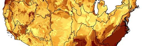
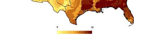
8 National Scale Ecoregion Trends, Figure Substantial gains and losses of land cover occur at the decadal-scale. Level III ecoregions shown.


9 Trends in US Land Conversion across four time-intervals Some of the most extensive land conversion dynamics for 4 time intervals between Level 3 ecoregions are shown.
 as well Mix of expansion")


10 Recent Findings LCCs Regional variability Temporal variability Accelerating rates However, there is also sectoral variability (LULC categories) as well Mix of expansion and decline 1 Appalachian 9 Gulf Coastal Plains and Ozarks 2 California 10 North Atlantic 3 Desert 11 North Pacific 4 Eastern Tallgrass Prairie 12 Peninsular Florida and Big Rivers 5 Great Basin 13 Plains and Prairie Potholes 6 Great Northern 14 South Atlantic 7 Great Plains 15 Southern Rockies 8 Gulf Coast Plains 16 Upper Midwest and Great Lakes
11 LCC Appalachian California Desert Eastern Tallgrass Prairie and Big Rivers Great Basin Great Northern G Great Plains Pl i Gulf Coast Prairie Gulf Coastal Plains and Ozarks North Atlantic North Pacific Peninsular Florida Plains and Prairie Potholes South Atlantic Southern Rockies Upper Midwest and Great Lakes Overall Spatial Change (percent of region)


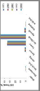
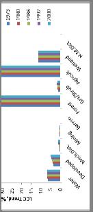
12 Trends of land cover change, Landscape-level variability of LULCC,


13 Investigating a long-term & current record of land change - Example from the South Central Plains, 1973 to 2010 We are extending the analysis to present Analyzing the causes, trends, and implications of recent land change occurring across the diversity of US ecoregions Systematically-collectedcollected Comparable across the U.S. Net change for 6 time intervals, Extent of change in Level IV ecoregions,


14 The National Landscape Variable rates of change In some cases, highest rates are due to one-type of land use (e.g. pine plantation) Areas of low rates may have diverse changes or intensive land use practices, e.g. fertilization, irrigation, etc Finer-level changes relate to the land use potential determined by biophysical setting and socioeconomic drivers Connection between assessment and consequence
15 Emerging Direction Consequences of land change Support DOI research needs within the LCC and CSC networks through regional consequences assessments that examine land use effects on earth systems and processes. Communicating land use effects on land conservation and management Land use effects conservation lands Land use impacts on hydrology and climate Land use impacts on habitat and species Effects of energy development
16 Conclusions An understanding of land management options for landscape conservation is anchored by an understanding of the regional variability of human-environmental interactions ti across the United States. These interactions include but are not limited to the rates, types of land conversion, driving forces, and consequences of land change. We address the issues of landscape change by: A systematic analysis of change across multiple scales Integration of land use information with land cover Identification of patterns and drivers of landscape change Targeted analyses of consequences to the national landscape


17 Summaries of Land Change in LCCs Publication in progress Summaries of LULC change results for each of the 16 CONUS LCCs THANK YOU! Krista Karstensen Mark Drummond
The Protection of Ecosystem Services in the US- Mexico Border
 The Protection of Ecosystem Services in the US- Mexico Border Lina Ojeda-Revah El Colegio de la Frontera Norte Christopher Brown New Mexico State University ACES 2010 Annual Meeting Gila River Indian Community
Northern Eurasia Earth Science Partnership Initiative (NEESPI) Mutlu Ozdogan (input from Pasha Groisman)
 Mutlu Ozdogan (input from Pasha Groisman)") Northern Eurasia Earth Science Partnership Initiative (NEESPI) Mutlu Ozdogan (input from Pasha Groisman) 1 NEESPI is an interdisciplinary program of internationally supported Earth systems and science
Northern Eurasia Earth Science Partnership Initiative (NEESPI) Mutlu Ozdogan (input from Pasha Groisman) 1 NEESPI is an interdisciplinary program of internationally supported Earth systems and science
discussion of North America s physical features, including its landforms and bodies of
 Chapter 7 Natural Environments of North America Chapter 7 focuses on the natural environments of North America. The chapter opens with a discussion of North America s physical features, including its landforms
Module 3. Basic Ecological Principles
 Module 3. Basic Ecological Principles Ecosystem Components Abiotic Biotic Species & Habitat The Biomes of North America Communities Energy & Matter Cycles in Ecosystems Primary Productivity Simple Ecosystem
The Influence of Historical and Projected Land Use and Land Cover Changes on Land Surface Hydrology and Regional Weather and Climate Variability
 The Influence of Historical and Projected Land Use and Land Cover Changes on Land Surface Hydrology and Regional Weather and Climate Variability Research Hypothesis: Land use and land cover changes are
Weather and Climate Summary and Forecast Winter
 Weather and Climate Summary and Forecast Winter 2016-17 Gregory V. Jones Southern Oregon University February 7, 2017 What a difference from last year at this time. Temperatures in January and February
Physiographic Provinces (West, Ch. 13)
") Geology 229 Engineering Geology Lecture 13 Physiographic Provinces (West, Ch. 13) The definition of the term Physiography Physiography (n.) The science which treats of the earth's exterior physical features,
Geology 229 Engineering Geology Lecture 13 Physiographic Provinces (West, Ch. 13) The definition of the term Physiography Physiography (n.) The science which treats of the earth's exterior physical features,
Five Themes of Geography Project Ms. Kiesel, Per 5. The United States of America
 Five Themes of Geography Project Ms. Kiesel, Per 5 The United States of America Location Absolute Location : The USA is located in the continent of North America in the northern and western hemispheres.
Weather and Climate Summary and Forecast January 2019 Report
 Weather and Climate Summary and Forecast January 2019 Report Gregory V. Jones Linfield College January 4, 2019 Summary: December was mild and dry over much of the west, while the east was much warmer than
The United States & Canada. A Regional Study of Anglo America
 A Regional Study of Anglo America Landform Regions of the United States & Canada world leaders in agricultural and industrial production because of... VAST LANDS stretch from the Atlantic Ocean on the
Subject Area: Geography
 Long Term Planning Overview Key Stage 3 Subject Area: Geography Academic : 08-9 7 Assessment Your Island Home the physical and human geography of the UK and will investigate weather patterns, population
NASA, EPA, USGS Partnership. U.S. Department of the Interior U.S. Geological Survey
 Spatial and Temporal Dimensions of Contemporary U.S. Land Cover/Land Use Change and Implications for Carbon Dynamics Tom Loveland and Shuguang Liu USGS EROS Data Center, Sioux Falls, SD NASA, EPA, USGS
4th Grade U.S. Regional Geography
 4th Grade U.S. Regional Geography Multiple Choice Identify the choice that best completes the statement or answers the question. What does the term mainland mean in the sentence above? A the continent
Guided Reading Activity
 Guided Reading Activity Lesson 1 Physical Features Essential Question: How does geography influence the way people live? A Vast Land Directions: Read the lesson and use your text to decide whether each
Unit 1: Geography. For additional information, refer to this website: 1 G e o g r a p h y
 Unit 1: Geography For additional information, refer to this website: http://mryoungtms.weebly.com/ 1 G e o g r a p h y Continents and Oceans SOL USI. 2a Essential Understanding: Continents are large land
THE GULF COAST VULNERABILITY ASSESSMENT:
 THE GULF COAST VULNERABILITY ASSESSMENT: Informing Adaptation Options in Landscape Conservation Design Cynthia Edwards GCPO and GCP LCC Wildlife Management Institute Peninsular Florida LCC Steering Committee
Weather and Climate Summary and Forecast January 2018 Report
 Weather and Climate Summary and Forecast January 2018 Report Gregory V. Jones Linfield College January 5, 2018 Summary: A persistent ridge of high pressure over the west in December produced strong inversions
Drought Impacts in the Southern Great Plains. Mark Shafer University of Oklahoma Norman, OK
 Drought Impacts in the Southern Great Plains Mark Shafer University of Oklahoma Norman, OK Causes of Drought: Large-Scale, Stationary High Pressure Air rotates clockwise around high pressure steers storms
Weather and Climate Summary and Forecast Winter
 Weather and Climate Summary and Forecast Winter 2016-17 Gregory V. Jones Southern Oregon University December 5, 2016 Well after an October that felt more like November, we just finished a November that
CLIMATOLOGY OF POSITIVE POLARITY FLASHES AND MULTIPLICITY AND THEIR RELATION TO NATURAL WILDFIRE IGNITIONS
 2006 19th International Lightning Detection Conference 24-25 April Tucson, Arizona, USA 1st International Lightning Meteorology Conference 26-27 April Tucson, Arizona, USA CLIMATOLOGY OF POSITIVE POLARITY
EQ: Discuss main geographic landforms of the U.S. & Canada and examine varied landforms in relation to their lifestyles.
 EQ: Discuss main geographic landforms of the U.S. & Canada and examine varied landforms in relation to their lifestyles. Places & Terms for Discussion Appalachian Mountains Great Plains Canadian Shield
PHYSIOGRAPHIC REGIONS OF THE LOWER 48 UNITED STATES
 PHYSIOGRAPHIC REGIONS OF THE LOWER 48 UNITED STATES LAURENTIAN UPLAND 1. Superior Upland ATLANTIC PLAIN 2. Continental Shelf (not on map) 3. Coastal Plain a. Embayed section b. Sea Island section c. Floridian
Mangrove Restoration and Migration in a Changing Climate: Climatic Drivers and Shifting Ecotones
 Mangrove Restoration and Migration in a Changing Climate: Climatic Drivers and Shifting Ecotones Michael J. Osland & Richard H. Day U.S. Geological Survey, National Wetlands Research Center U.S. Department
Weather and Climate Summary and Forecast Summer 2017
 Weather and Climate Summary and Forecast Summer 2017 Gregory V. Jones Southern Oregon University August 4, 2017 July largely held true to forecast, although it ended with the start of one of the most extreme
Assessing state-wide biodiversity in the Florida Gap analysis project
 University of Nebraska - Lincoln DigitalCommons@University of Nebraska - Lincoln Nebraska Cooperative Fish & Wildlife Research Unit -- Staff Publications Nebraska Cooperative Fish & Wildlife Research Unit
Erik Kabela and Greg Carbone, Department of Geography, University of South Carolina
 Downscaling climate change information for water resources Erik Kabela and Greg Carbone, Department of Geography, University of South Carolina As decision makers evaluate future water resources, they often
The Role of Wilderness in Climate Change Adaptation
 The Role of Wilderness in Climate Change Adaptation A Case Study of the Northern Rockies Greg Aplet, Bo Wilmer Goal: Sustaining Ecosystem Services Sustaining the full suite of benefits we receive from
Kimberly J. Mueller Risk Management Solutions, Newark, CA. Dr. Auguste Boissonade Risk Management Solutions, Newark, CA
 1.3 The Utility of Surface Roughness Datasets in the Modeling of United States Hurricane Property Losses Kimberly J. Mueller Risk Management Solutions, Newark, CA Dr. Auguste Boissonade Risk Management
Weather and Climate Summary and Forecast October 2017 Report
 Weather and Climate Summary and Forecast October 2017 Report Gregory V. Jones Linfield College October 4, 2017 Summary: Typical variability in September temperatures with the onset of fall conditions evident
SEASONAL CLIMATE OUTLOOK VALID FOR JULY-AUGUST- SEPTEMBER 2013 IN WEST AFRICA, CHAD AND CAMEROON
 SEASONAL CLIMATE OUTLOOK VALID FOR JULY-AUGUST- SEPTEMBER 2013 IN WEST AFRICA, CHAD AND CAMEROON May 29, 2013 ABUJA-Federal Republic of Nigeria 1 EXECUTIVE SUMMARY Given the current Sea Surface and sub-surface
Weather and Climate Summary and Forecast December 2017 Report
 Weather and Climate Summary and Forecast December 2017 Report Gregory V. Jones Linfield College December 5, 2017 Summary: November was relatively cool and wet from central California throughout most of
Climate. Annual Temperature (Last 30 Years) January Temperature. July Temperature. Average Precipitation (Last 30 Years)
 January Temperature. July Temperature. Average Precipitation (Last 30 Years)") Climate Annual Temperature (Last 30 Years) Average Annual High Temp. (F)70, (C)21 Average Annual Low Temp. (F)43, (C)6 January Temperature Average January High Temp. (F)48, (C)9 Average January Low Temp.
Climate Annual Temperature (Last 30 Years) Average Annual High Temp. (F)70, (C)21 Average Annual Low Temp. (F)43, (C)6 January Temperature Average January High Temp. (F)48, (C)9 Average January Low Temp.
United States Streamflow Probabilities based on Forecasted La Niña, Winter-Spring 2000
 United States Streamflow Probabilities based on Forecasted La Niña, Winter-Spring 2000 contributed by Michael D. Dettinger 1, Daniel R. Cayan 1, and Kelly T. Redmond 2 1 U.S. Geological Survey, Scripps
Weather and Climate Summary and Forecast February 2018 Report
 Weather and Climate Summary and Forecast February 2018 Report Gregory V. Jones Linfield College February 5, 2018 Summary: For the majority of the month of January the persistent ridge of high pressure
MARKET WIRE. Jason Vollmer (701) Trygg Olson (701) Nick Smith (701) Adam Allmaras (701)
 Trygg Olson (701) Nick Smith (701) Adam Allmaras (701)") MARKET WIRE Quick Notes: New news in the corn market is limited. Markets continue to see spillover from Friday s USDA report. Carryout was unchanged in Friday s report and exports continue to remain sluggish.
MARKET WIRE Quick Notes: New news in the corn market is limited. Markets continue to see spillover from Friday s USDA report. Carryout was unchanged in Friday s report and exports continue to remain sluggish.
Weather and Climate Summary and Forecast March 2018 Report
 Weather and Climate Summary and Forecast March 2018 Report Gregory V. Jones Linfield College March 7, 2018 Summary: The ridge pattern that brought drier and warmer conditions from December through most
Modeling Smart Growth in the Southeast Using Smart-SLEUTH. November 20, 2014 SOUTH ATLANTIC LCC WEB FORUM Monica A. Dorning
 Modeling Smart Growth in the Southeast Using Smart-SLEUTH November 20, 2014 SOUTH ATLANTIC LCC WEB FORUM Monica A. Dorning (Sub)Urbanization in the Southeast November 20, 2014 SOUTH ATLANTIC LCC WEB FORUM
Is Ignoring Evolution Intelligent Design for Conservation? Mark Reynolds, Gretchen LeBuhn, Dick Cameron, and Rebecca Shaw
 Is Ignoring Evolution Intelligent Design for Conservation? Mark Reynolds, Gretchen LeBuhn, Dick Cameron, and Rebecca Shaw Outline Evolution and Conservation Practice Biodiversity Pattern and Process Global
Earth s Layers. Earth s Surface
 CHAPTER 1 LESSON 3 Earth s Layers Earth s Surface Key Concepts What are Earth s major landforms and how do they compare? What are the major landform regions of the United States? What do you think? Read
CHAPTER 1. Geo Challenges 1A to 1D. & World Map Activity
 CHAPTER 1 Geo Challenges 1A to 1D & World Map Activity SELECT YOUR CHALLENGE World Map Activity Challenge 1A Challenge 1B Challenge 1C Challenge 1D Challenge 1A WS PG. 2 STEP #1 Label the largest continent
Regional Geography C. LANGDON WHITE. Professor Emeritus Stanford University EDWIN J. FOSCUE TOM L. MCKNIGHT
 Regional Geography of Anglo-America Sixth Edition C. LANGDON WHITE Professor Emeritus Stanford University EDWIN J. FOSCUE Late of Southern Methodist University TOM L. MCKNIGHT Professor of Geography University
of a landscape to support biodiversity and ecosystem processes and provide ecosystem services in face of various disturbances.
 L LANDSCAPE ECOLOGY JIANGUO WU Arizona State University Spatial heterogeneity is ubiquitous in all ecological systems, underlining the significance of the pattern process relationship and the scale of
Mapping and Assessment of Ecosystems and their Services
 Mapping and Assessment of Ecosystems and their Services ALTER-Net Conference 2013: Science underpinning the EU 2020 Biodiversity Strategy. April 2013 Gent Joachim MAES 1 This presentation is based on the
Unit 2. United States Physical Geography
 Unit 2 United States Physical Geography Physical Geography U.S. extends from the Atlantic to Pacific U.S. is the 3rd largest country U.S. has fertile soils, vast forests, and variety of minerals All major
Future population exposure to US heat extremes
 Outline SUPPLEMENTARY INFORMATION DOI: 10.1038/NCLIMATE2631 Future population exposure to US heat extremes Jones, O Neill, McDaniel, McGinnis, Mearns & Tebaldi This Supplementary Information contains additional
Preliminary Results from Coordinated Sea-Level Rise Modeling Using SLAMM, the Sea Level Affecting Marshes Model, Across the US Gulf of Mexico Coast
 Preliminary Results from Coordinated Sea-Level Rise Modeling Using SLAMM, the Sea Level Affecting Marshes Model, Across the US Gulf of Mexico Coast James W. Pahl, Ph.D., and Kristin DeMarco, State of Louisiana
Changes in Texas Ecoregions
 Comment On Lesson Changes in Texas Ecoregions The state of Texas can be divided into 10 distinct areas based on unique combinations of vegetation, topography, landforms, wildlife, soil, rock, climate,
Name period date assigned date due date returned. Texas Ecoregions
 Name period date assigned date due date returned Directions: Go to the following website: https://www-k6.thinkcentral.com/epc/start.do Use the log in that is taped to the top of your laptop. If you are
Mesonets and Drought Early Warning
 Mesonets and Drought Early Warning Stuart A. Foster Kentucky Climate Center Western Kentucky University 2017 Regional Mesonet Partners Workshop Champaign, Illinois March 23, 2017 Maximizing the Value of
Variability Across Space
 Variability and Vulnerability of Western US Snowpack Potential impacts of Climactic Change Mark Losleben, Kurt Chowanski Mountain Research Station, University of Colorado Introduction The Western United
Weather and Climate Summary and Forecast March 2019 Report
 Weather and Climate Summary and Forecast March 2019 Report Gregory V. Jones Linfield College March 2, 2019 Summary: Dramatic flip from a mild winter to a top five coldest February on record in many locations
Accounting for Ecosystem and Biodiversity Related Themes in Uganda
 Introduction Accounting for Ecosystem and Biodiversity Related Themes in Uganda Calls for more evidence-based approaches to policy have increased the need for integrated environmental-economic information
Overview of Methods. Terrestrial areas that are most important for conservation Conservation
 Overview of Methods The goal of the Western Lake Erie Coastal Conservation Vision project (WLECCV) is to define where we should be working locally to optimally achieve regional conservation impact. The
Climate Change in Colorado: Recent Trends, Future Projections and Impacts An Update to the Executive Summary of the 2014 Report
 Climate Change in Colorado: Recent Trends, Future Projections and Impacts An Update to the Executive Summary of the 2014 Report Jeff Lukas, Western Water Assessment, University of Colorado Boulder - Lukas@colorado.edu
Weather and Climate Summary and Forecast April 2018 Report
 Weather and Climate Summary and Forecast April 2018 Report Gregory V. Jones Linfield College April 4, 2018 Summary: A near Miracle March played out bringing cooler and wetter conditions to the majority
COMMON CONCEPTUAL AND OPERATIONAL FRAMEWORKS FOR RESEARCH AND SUSTAINABLE MANAGEMENT OF NESTED SOCIO-ECOLOGICAL SYSTEMS ACROSS LARGE WATERSHEDS
 COMMON CONCEPTUAL AND OPERATIONAL FRAMEWORKS FOR RESEARCH AND SUSTAINABLE MANAGEMENT OF NESTED SOCIO-ECOLOGICAL SYSTEMS ACROSS LARGE WATERSHEDS Angheluta VADINEANU 1 & Nusret KARAKAYA 2 1 Department of
Weather and Climate Summary and Forecast Summer 2016
 Weather and Climate Summary and Forecast Summer 2016 Gregory V. Jones Southern Oregon University June 6, 2016 May 2016 continued the warm trend for portions of the west, while providing some relief for
The U.S. National Integrated Drought Information System. Roger S. Pulwarty National Oceanic and Atmospheric Administration USA
 The U.S. National Integrated Drought Information System Roger S. Pulwarty National Oceanic and Atmospheric Administration USA Drought: Weather-climate continuum and adaptation deficits 2010 2011 2012 2015
Greening of Arctic: Knowledge and Uncertainties
 Greening of Arctic: Knowledge and Uncertainties Jiong Jia, Hesong Wang Chinese Academy of Science jiong@tea.ac.cn Howie Epstein Skip Walker Moscow, January 28, 2008 Global Warming and Its Impact IMPACTS
Application of Remote Sensing Techniques for Change Detection in Land Use/ Land Cover of Ratnagiri District, Maharashtra
 IOSR Journal of Applied Geology and Geophysics (IOSR-JAGG) e-issn: 2321 0990, p-issn: 2321 0982.Volume 3, Issue 6 Ver. II (Nov. - Dec. 2015), PP 55-60 www.iosrjournals.org Application of Remote Sensing
Doug Kluck Regional Climate Services Director Kansas City, MO
 Climate Resilience and Information: Opportunities with Tribes and the National Oceanic and Atmospheric Administration (NOAA) and Partners National Congress of American Indians Annual Convention (October
Chapter 1: America s Land Lesson 1: Land and Climate
 Chapter 1: America s Land Lesson 1: Land and Climate Geography: Describe landforms and other physical features of the United States. Geography: Explain how and why climate varies throughout the United
The Coastal Change Analysis Program and the Land Cover Atlas. Rebecca Love NOAA Office for Coastal Management
 The Coastal Change Analysis Program and the Land Cover Atlas Rebecca Love NOAA Office for Coastal Management Natural Infrastructure = Greater Resilience NOAA C-CAP Regional Land Cover and Change coast.noaa.gov/digitalcoast/data/ccapregional
3rd LCLUC Science Team Meeting Airlie House, Warrenton, Va May
 3rd LCLUC Science Team Meeting Airlie House, Warrenton, Va May 18-21 1999 May 18 th Day 1, 9.00 am Plenary Session - The Jefferson Room Welcome and Objectives of the Meeting C. Justice / J. Ranson Programmatic
Marine Ecoregions. Marine Ecoregions. Slide 1. Robert G. Bailey. USDA Forest Service Rocky Mountain Research Station
 Slide 1 Marine Ecoregions Robert G. Bailey Marine Ecoregions Robert G. Bailey USDA Forest Service Rocky Mountain Research Station rgbailey@fs.fed.us Draft of 7/20/2006 8:44 PM Abstract: Oceans occupy some
Latest Press Release. sarah palin leg show
 corp@stantec.com Latest Press Release sarah palin leg show S The South Texas Sand Sheet, also known as the Coastal Sand Plains and the Llano Mesteño, occupies more than two million acres at the southern
Spatial and Temporal Variability in Snowpack Controls: Two Decades of SnoTel Data from the Western U.S.
 Spatial and Temporal Variability in Snowpack Controls: Two Decades of SnoTel Data from the Western U.S. Spatial and Temporal Variability in Snowpack Controls: Two Decades of SnoTel Data from the Western
Biodiversity-Hotspots
 GE 2211 Environmental Science and Engineering Unit II Biodiversity-Hotspots M. Subramanian Assistant Professor Department of Chemical Engineering Sri Sivasubramaniya Nadar College of Engineering Kalavakkam
LATITUDE. Latitude lines run to, but are measured & The 0 of latitude that circles the earth is called the?
 LATITUDE Latitude lines run to, but are measured & The 0 of latitude that circles the earth is called the? LATITUDE 0 0 Latitude lines run east to west, but are measured north & south The 0 of latitude
CLIMATE READY BOSTON. Climate Projections Consensus ADAPTED FROM THE BOSTON RESEARCH ADVISORY GROUP REPORT MAY 2016
 CLIMATE READY BOSTON Sasaki Steering Committee Meeting, March 28 nd, 2016 Climate Projections Consensus ADAPTED FROM THE BOSTON RESEARCH ADVISORY GROUP REPORT MAY 2016 WHAT S IN STORE FOR BOSTON S CLIMATE?
Weather and Climate Summary and Forecast Summer 2016
 Weather and Climate Summary and Forecast Summer 2016 Gregory V. Jones Southern Oregon University August 5, 2016 The month of July saw the continued flip, flop of the western US temperatures. It was warm
Lesson 9: California Ecosystem and Geography
 California Education Standards: Kindergarten, Earth Sciences 3. Earth is composed of land air, and water. As a basis for understanding this concept: b. Students know changes in weather occur from day to
Topography of the conterminous United States
 Topography of the conterminous United States Potential Natural Vegetation Geology Coastal Ranges physiographic province Cascade-Sierra Mountains Cascades Mount Hood California central valley Sierra-Nevada
Monthly Long Range Weather Commentary Issued: February 15, 2015 Steven A. Root, CCM, President/CEO
 Monthly Long Range Weather Commentary Issued: February 15, 2015 Steven A. Root, CCM, President/CEO sroot@weatherbank.com JANUARY 2015 Climate Highlights The Month in Review During January, the average
EnviroAtlas: An Atlas about Ecosystems and their Connection with People
 EnviroAtlas: An Atlas about Ecosystems and their Connection with People Annie Neale, Megan Mehaffey & Atlas Team ASWM Webinar October, 17 th, 2012 What is it? The Atlas is an online decision support tool
Doug Kluck NOAA Kansas City, MO National Center for Environmental Information (NCEI) National Integrated Drought Information System (NIDIS)
 National Integrated Drought Information System (NIDIS)") National Integrated Drought Information System (NIDIS) for the Missouri River Basin Drought Early Warning Information System (DEWS) & Runoff Trends in the Missouri Basin & Latest Flood Outlook Doug Kluck
National Integrated Drought Information System (NIDIS) for the Missouri River Basin Drought Early Warning Information System (DEWS) & Runoff Trends in the Missouri Basin & Latest Flood Outlook Doug Kluck
Weather and Climate Summary and Forecast November 2017 Report
 Weather and Climate Summary and Forecast November 2017 Report Gregory V. Jones Linfield College November 7, 2017 Summary: October was relatively cool and wet north, while warm and very dry south. Dry conditions
Population Trends Along the Coastal United States:
 Coastal Trends Report Series Population Trends Along the Coastal United States: 1980-2008 U.S. Department of Commerce National Oceanic and Atmospheric Administration National Ocean Service Assessing the
Cross-border Maritime Spatial Plan for the Black sea - Romania and Bulgaria project
 Cross-border Maritime Spatial Plan for the Black sea - Romania and Bulgaria project in Romania and Bulgaria Plan Presentation A first step in the management of the marine areas of Romania and Bulgaria
OSS MISSION.
 GEO-CRADLE COORDINATING AND INTEGRATING STATE-OF-THE-ART EARTH OBSERVATION ACTIVITIES IN THE REGION OF NORTH OF AFRICA, MIDDLE EAST, AND BALKANS AND DEVELOPING LINKS WITH GEO RELATED INITIATIVES TOWARD
Long-Term Patterns of Coastal Response to Changing Land Use and Climate: Examples from the Atlantic and Gulf Coastal Plains
 Long-Term Patterns of Coastal Response to Changing Land Use and Climate: Examples from the Atlantic and Gulf Coastal Plains Debra Willard, Christopher Bernhardt, and Miriam Jones U.S. Geological Survey,
Wetland Mapping. Wetland Mapping in the United States. State Wetland Losses 53% in Lower US. Matthew J. Gray University of Tennessee
 Wetland Mapping Caribbean Matthew J. Gray University of Tennessee Wetland Mapping in the United States Shaw and Fredine (1956) National Wetlands Inventory U.S. Fish and Wildlife Service is the principle
LAND CHANGE MODELER SOFTWARE FOR ARCGIS
 LAND CHANGE MODELER SOFTWARE FOR ARCGIS The Land Change Modeler is revolutionary land cover change analysis and prediction software which also incorporates tools that allow you to analyze, measure and
Name period date assigned date due date returned. Texas Ecoregions
 Name period date assigned date due date returned Directions: Go to the following website: https://www-k6.thinkcentral.com/epc/start.do Use the log in that is taped to the top of your laptop. If you are
US Bird Conservation Regions
 US Bird Conservation Regions Completion of Requested Changes (2009-2012) Produced for U.S. NABCI 10 July 2012 Updated December 2012 Eva Jenkins (ejenkins@birdscanada.org) Andrew Couturier (acouturier@birdscanada.org)
Physical Geography of the United States and Canada Chapter 5 A Land of Contrasts
 Physical Geography of the United States and Canada Chapter 5 A Land of Contrasts Land Area Together the U.S. and Canada cover more than 7 million square miles. In total area, Canada ranks 2 nd and the
Land Use/Land Cover Mapping in and around South Chennai Using Remote Sensing and GIS Techniques ABSTRACT
 Land Use/Land Cover Mapping in and around South Chennai Using Remote Sensing and GIS Techniques *K. Ilayaraja, Abhishek Singh, Dhiraj Jha, Kriezo Kiso, Amson Bharath institute of Science and Technology
Mapping Water Resources and Reservoirs for Climate Resilience in Zambezi River Basin
 Mapping Water Resources and Reservoirs for Climate Resilience in Zambezi River Basin Corné van der Sande, NEO BV Senior Advisor Earth Observation Services for Monitoring Drought and Water Resources in
Regional Climate Variability in the Western U.S.: Observed vs. Anticipated
 Regional Climate Variability in the Western U.S.: Observed vs. Anticipated Klaus Wolter University of Colorado at Boulder, klaus.wolter@noaa.gov Kudos to Joe Barsugli and Jon Eischeid Seasonal Precipitation
4th Grade Social Studies First Nine Weeks
 4th Grade Social Studies First Nine Weeks Multiple Choice Identify the choice that best completes the statement or answers the question. 1 Name the mountains that are located in the eastern United States.
Marine Spatial Planning: A Tool for Implementing Ecosystem-Based Management
 Marine Spatial Planning: A Tool for Implementing Ecosystem-Based Management Steven Murawski, Ph.D., Ecosystem Goal Team Lead National Oceanic and Atmospheric Administration NOAA November 16, 2009 1 To
Introduction: The Gulf of Mexico Alliance. The Gulf GAME project MERMAid and PHINS Results & Conclusions What s next? Examples
 AAG Las Vegas March 25, 2009 Introduction: Ocean governance and Ecosystem-Based Management The Gulf of Mexico Alliance Habitat Identification and Characterization The Gulf GAME project MERMAid and PHINS
Liana Talaue McManus. Division of Marine Affairs and Policy Rosenstiel School of Marine & Atmospheric Science University of Miami
 Liana Talaue McManus Division of Marine Affairs and Policy Rosenstiel School of Marine & Atmospheric Science University of Miami Outline 1. Coasts as vulnerable & resilient social ecological systems 2.
NetRA Resources Assessment (NetRA) 1
 1") NetRA Resources Assessment (NetRA) 1 Dadhi Ram Adhikari Economist 2 Christopher Babis -Water Resources Policy Richard L. Bernknopf- Economist Craig D. Broadbent- Economist David S. Brookshire- Economist
NetRA Resources Assessment (NetRA) 1 Dadhi Ram Adhikari Economist 2 Christopher Babis -Water Resources Policy Richard L. Bernknopf- Economist Craig D. Broadbent- Economist David S. Brookshire- Economist
USGS Water Census Guidelines and Specifications for ET Remote Sensing
 USGS Water Census Guidelines and Specifications for ET Remote Sensing U.S. Department of the Interior U.S. Geological Survey Guidelines and specifications Many prior and ongoing crop ET remote sensing
Disturbance, site, and vegetation feedbacks create landscape structure in South Florida coastal wetlands. M Ross, K Zhang, B Thapa, and D Gann
 Disturbance, site, and vegetation feedbacks create landscape structure in South Florida coastal wetlands M Ross, K Zhang, B Thapa, and D Gann Department of Earth & Environment Florida International University
Global reviews of wetland inventory, classification and delineation
 Max Finlayson Institute for Land, Water & Society Charles Sturt University Albury, Australia Global reviews of wetland inventory, classification and delineation Initiatives/meetings over two decades have
National Wildland Significant Fire Potential Outlook
 National Wildland Significant Fire Potential Outlook National Interagency Fire Center Predictive Services Issued: April 1, 2008 Next Issue: May 1, 2008 Wildland Fire Outlook April 2008 through July 2008
GUIDED READING CHAPTER 1: THE LAY OF THE LAND (Page 1)
") CHAPTER 1: THE LAY OF THE LAND (Page 1) Section 1 The Tidewater Region Directions: Use the information from pages 6-11 to complete the following statements. 1. In the southern part of the coast, the Tidewater
CHAPTER 1: THE LAY OF THE LAND (Page 1) Section 1 The Tidewater Region Directions: Use the information from pages 6-11 to complete the following statements. 1. In the southern part of the coast, the Tidewater
Chapter 32. Australia & New Zealand
 Chapter 32 Australia & New Zealand Lesson 1: Physical Geography of Australia & New Zealand Landforms Australia lies between the Pacific and Indian Oceans in the Southern Hemisphere. Although an island,