The Quaternary Dextral Shearing in the Southeastern. Tibetan Plateau
|
|
|
- Adela Barnett
- 5 years ago
- Views:
Transcription
1 The Quaternary Dextral Shearing in the Southeastern Tibetan Plateau SHEN Jun Wang Yipeng REN Jinwei CAO Zhongquan Institute of Geology of China Seismological Bureau, Beijing , China Tel: , Fax: ; Abstract: The field study on the Jiali fault zone in the southeast of Tibetan Plateau and the Deqin-zhongdian-Daju fault in the northwest of Yunnan province, China indicate that There is no integrated dextral shearing zone defining the south boundary of the eastward extrusive Plateau. The western segment of the Jiali fault zone is the transform fault with high slip rate between grabens in south Tibet, which is a W-E extension region under the N-S compression. The Deqin-Zhongdian-Daju fault, together with the Red River fault, defines the southwestern boundary of the southeastward escaping rhombic Sichuan-Yunnan Block which is south part of the eastward escaping main body of the Tibetan Plateau. The southern crust of the Tibetan Plateau is more plastic and easier to flow eastward due to the higher temperature. Unlike the northern boundary of the Tibetan Plateau, on where large left lateral strike slip faults developed, in southern Tibetan Plateau, many smaller right lateral slip faults distribute in a very wide belt in steady of an integrated fault. Key words: Tibetan Plateau, Jiali fault zone, Dextral Shearing Zone, eastward extrusion 1. Introduction The convergence between the India and the Asia induced the intensive deformation in the Tibetan Plateau. In the late Cenozoic, the Tibetan Plateau undergoes the deformations of various styles (Wang, 1996). The first is the crustal shortening, thickening and uplifting of the plateau under the N-S compression(chang,1988) resulting in nappes or thrust faults on the piedmonts of the boundary mountains in and surrounding the Plateau. The second is the collapsing and extension of the Tibetan Plateau, resulting in grabens and detachment faults in the southern and central Tibetan Plateau. The third is the Eastward extrusion or escaping of the main body of the Tibetan Plateau(Tapponnier, 1976,1977,1979,1982). The last is the clockwise rotation of the E-W orientation tabular blocks in the Tibetan Plateau, resulting large left lateral strike slip fault in the eastern edge of the plateau(england, 1990). The eastward extrusion/escaping is important, even though there are many debates among the geologists on its magnitude, mechanism. The lateral extrusion/escaping of the main body of the plateau forms the large shearing zones along the boundary and between tabular secondary blocks. The sinistral shearing zones in the north are obvious and recognized by many geologist, such as the Altyn Tagh Fault Zone along the north boundary of Tibet Plateau (slip rate 10-30mm/a), the
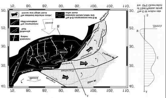
2 East Kunlun Fault Zone (slip rate 10mm/a) and the Xianshuihe-Xiaojiang Fault zone (slip rate 10-15mm/a) (Van, 1998). The Quaternary dextral shearing zones in southern Tibetan Plateau are also recognized. One is the Red River Fault zone in Yunnan Province of China (3-5mm/a)(Allen,1989). It is a right lateral strike slip fault since late Pliocene. Another is the Karakorum Fault zone along the west edge of the Tibetan Plateau. In addition, it is supposed there is a dextral shearing zone in southern Tibetan Plateau (Fig.1), consisting of several WNW right lateral strike slip faults, include the Peng Co fault, Coring Co Fault (Amijio, 1986). Fig.1 The eastward extrusion of Tibetan Plateau proposed by Armijio et al. (1986) How far can the dextral shearing zone in the south Tibetan Plateau extend eastward? Can it connect with the Red River Fault and form an integrated southern boundary dextral shearing zone of the eastward extrusive main body of the Tibetan Plateau? In the past three years we investigated in southeast Tibet and northwest Yunnan province, China. Jiali right lateral strike slip fault, Daju right lateral strike slip fault and the area between them were studied. The goal is to make sure if there is an integrated dextral shearing zone defining the south boundary of the eastward extrusive Tibetan Plateau. 2. Study method Satellite images, air-photographs and large scale DEMs (digitized elevation maps) were used to analyze the fault induced morphologic deformation, find the distribution of the fault. Field investigation was to find more direct evidence of displacement, map the typical deformation phenomenon, collect dating samples and analyze the brittle and ductile rupture zone, the deposit in the fault zone, the fault outcrops, deformed roock layers close to the fault. C 14 and TL(Thermoluminescence) dating methods were used to get the deformation age. In order to get a more convincing estimation on the slip rate of the strike slip faults, regional analysis on the ages of the deformed morphological terraces were made. The relationship between the ages of terraces and streams with the climate changes were set up. 3. Jiali right lateral strike slip fault in southeast Tibet Jiali fault zone is the southeast part of the right-lateral strike-slipping Karakurom-Jiali fault zone supposed by Armijio et al. (1989). The geometry of the Jiali fault is composed of three segments. The northwest segment is the NW trending right-lateral strike-slipping faults, which are accompany with the NNE oriented grabens and semi-grabens in central Tibet. The middle segment is the NWW trending right lateral strike slipping faults along the Yigung Zangbo River. The southeast segment is the Tungmai-Xiachayu fault. The Quaternary active faults in the east of Jiali fault zone is NW or NNW trending right lateral strike slip normal faults. Such as the Ranwu fault. The NW trending strike-slipping faults have many similar characteristics of the same trending faults in the extensional area in the south Tibet, such as the Peng Co
3 fault and Curing Co fault. Those fault bounded the end of the grabens or semi-grabens in south Tibet and have more clear morphological evidences of faster right lateral strike slipping sense in the boundary of the grabens and semi-grabens, and diminish quickly apart from the grabens or semi-grabens(ren,2000; Shen,2001a). The NE trending faults adjoined to the NW trending faults is also highly active and formed many fresh fault scarp and large dip slipping at the sides of the grabens, such as the Daren and Sangdi basins in the northwest segment of Jiali fault. The right lateral strike slipping sense along the NWW trending fault in the middle segment of the Jiali fault is not very clear either in morphology and geology(shen,2001a). We researched the drainage and ridge offsets supposed by Armijio et al(1989), and found them were isolated phenomena which might not make the convictive evidences of the right lateral strike slipping at the rate up to 10~20mm/a as Armijo et al. estimated. Judging from the data of field measurement and Dating samples, we estimated the right lateral strike-slipping rate of the NW trending fault in the northwest part of Jiali fault zone up to 10mm/a since late Pleistocene and 6~8mm/a since middle Pleistocene, while that of the NW trending secondary fault in the middle segment of the fault zone is no more than 2-3mm/a 4. Deqin-Zhongdian-Daju right lateral strike slip fault in northwest Yunnan Deqin-Zhongdian-Daju fault is a 300km long NW trending right-lateral strike-slip fault, from Deqin to Yongsheng in Yunnan Province, China. It is consisted of 4 segment. Zhongdian basin and Daju basin formed along the fault. The fault initiated since late Pliocene or early Quaternary(Shen, 2001b). The largest offsets is about 2.5 km. Drainage offsets of various scales can be found in the southeast of Deqing, the north boundary of Zhongdian Basin, east to Xiao-Zhongdian valley, the north piedmont of Haba snow capped mountain, the Daju basin and Dadong valley. The observed offsets are formed since middle Pleistocene. The average slip rate since middle Quaternary is 4-6mm/a Together with the Red River fault, it is the south boundary of the southeastward extrusive Sichuan-Yunnan massif. It combined with the Lancangjiang fault in the west, and doesn't cross the Henduanshan Mountains of southeast Tibet. It is impossible to connect the Deqin-Zhongdian-Daju fault with the Kalakun-Jiali fault. 5. Conclusion and discussion There is not a continuous large slip rate boundary dextral fault of the extrusive Tibetan Plateau. The deformation mechanism of the Tibet plateau is far more complex than what have predicted before. However, this is not contrary with the fact of the large scale eastward escaping of the Tibetan Plateau. The escaping main body is the northeast Tibetan Plateau, roughly the Qiadam Massif and Bayan Har Massif(Fig.2). The north boundary is Altun Tag Fault. The south boundary are Kekexili mountains, the Tanggula Mountains and the Taniantaweng Mountains, instead of the Kalakunlun-Jiali fault zone. The east-west extension of the southwest part of the Tibetan Plateau take place of the large slip rate south boundary dextral fault. The
4 WNW trending right lateral strike slip fault in south Tibet, include the Beng Co fault, the Cering Co fault and the northwest segment of Jiali fault, are transform fault, resulting from the E-W extension of the southwest Tibetan Plateau. Fig. 2 The eastward escaping model of the Tibetan Plateau The different dynamics environment between the southern and the northern Tibetan Plateau makes the different deformation style in the two region. The southern crust of the Tibetan Plateau is more plastic and easier to flow eastward due to the higher temperature. Unlike the northern boundary of the Tibetan Plateau, on where large left lateral strike slip faults developed, in southern Tibetan Plateau, many smaller right lateral slip faults distribute in a very wide belt in steady of an integrated fault. Reference Allen, C.R., Han Y., K.E.Sieh, Zhang B., and Zhu C., 1984, Red River and associate faults, Yunnan Province, China, Quaternary geology, slip rates and seismic synthesis, J.G.R., Vol.89, pp.10311~ Armijo, R., P.Tapponnier, J.L. Mercier, and T. Han, 1986, Quaternary extension in southern Tibet: field observations and tectonic implications, J.G.R., 91(B14): 13803~13872 Armijo, R., P. Tapponnier, and T. Han, 1989, Late Cenozoic right-lateral strike-slip faulting in southern Tibet, J.G.R., 94(B3): 2787~2838 Avouac, J.P., and P.Tapponnier, 1993, Kinetic model of active deformation in central Aisa, Geophysical Research Letters, Vol. 20, No.10, pp.2787~2837 Chang Chengfa, Robert, M Shachleton et al., 1988,The geological evolution of Tibet, London: The Royal Society, 1~413 Deway J.F, Stephen Cande and Walter C Pitman, 1989, Tectonic evolution of the India/Eurasia Collision Zone. Eclogae. Geol. Helv, 82(3):717~734 England P.C. and Molnar P., 1990, Right-lateral shear and rotation as the explanation for strike-slip faulting in Eastern Tibet, Nature,344:109~110 England, P. and Molnar P., 1997, The field of crust velocity in Asia calculated from Quaternary rates of slip on faults, J.G.R, 94:2,787~2,838 Mercier J.L., R.Armijo, P.Tapponnier, E. Carey, Molnar, P., P. Tapponnier, 1975, Cenozoic tectonics of Asia: effects of a continental collision, Science, 189,419~426 Molnar, P., P. Tapponnier, 1975, Cenozoic tectonics of Asia: effects of a continental collision, Science, 189,419~426 Ren Jinwei, Shen Jun, Cao Zhongquan and Wang Yipeng, 2000, Quaternary Faulting of Jiali Fault, Southeast Tibetan Plateau, Seismology and Geology, Vol.22, No.4:344~350(in Chinese) Shen Jun, Renjing Wei, Wang Yipeng, Cao Zhongquan, 2001a, The late Quaternary Right-lateral Strike-slipping of Jiali Fault Zone, Research On Active Fault, 8, Seismological Press, Beijing China, 149~158(in Chinses) Shen Jun, Renjing Wei, Wang Yipeng,2001b,The Quaternary right-lateral strike-slipping Deqin-Zhongdian-Daju fault in Yunnan, China, in Ma Zongjin et al. Edit: The Recent Deformation and Dynamics of Lithosphere in the Xizang-Qinghai Plateau, Seismological Press, Beijing, in printing(in Chinese). Tapponnier P. and Molnar P., 1976, Slip-line field theory and large scale continental tectonics, Nature, 264,319 Tapponnier, P., P.Molnar, 1977, Active faulting and tectonics in china, J.G.R., 82(20): 2905~2930.
5 Tapponnier, P., P. Molnar, 1979, Active faulting and Cenozoic tectonics of the Tian Shan, Mongolia and Baykal regions, J.G.R., 84(3): 3425~3459 Tapponnier, P., ET al., 1982, Propagating extrusion tectonics in Asia: new insights from simple experiments with plasticine, Geology, 10: 611~616 Van Der Woer, J., F. J. Ryerson, P.Tapponnier, et al., 1998, Holocene left-lateral left-slip rate determined by cosmogenic surface dating on the Xidatan segment of the Kunlun fault Qinghai, China, Geology, vol.26, no.8, p.695~698 Wang Yipeng,1996,Principal Features of the Active tectonics in Qinghai Xizang Plateau, Journal of Earthquake Prediction Research 5, 348~362 Zhang Peizhen, P. Molnar and W.R.Downs, 2001, Increased sedmentation rates and grain sizes 2-4 Myr ago due to influence of climate change on erosion rates, Nature, vol.401, 19,

6 Figure1 Figure2
DEFORMATION KINEMATICS OF TIBETAN PLATEAU DETERMINED FROM GPS OBSERVATIONS
 DEFORMATION KINEMATICS OF TIBETAN PLATEAU DETERMINED FROM GPS OBSERVATIONS Jinwei Ren Institute of Geology, China Seismological Bureau, Beijing 100029 China Tel: (10)62009095; Fax: (10)62009003; email:
Study on the feature of surface rupture zone of the west of Kunlunshan pass earthquake ( M S 811) with high spatial resolution satellite images
 with high spatial resolution satellite images") 48 2 2005 3 CHINESE JOURNAL OF GEOPHYSICS Vol. 48, No. 2 Mar., 2005,,. M S 811.,2005,48 (2) :321 326 Shan X J, Li J H, Ma C. Study on the feature of surface rupture zone of the West of Kunlunshan Pass
48 2 2005 3 CHINESE JOURNAL OF GEOPHYSICS Vol. 48, No. 2 Mar., 2005,,. M S 811.,2005,48 (2) :321 326 Shan X J, Li J H, Ma C. Study on the feature of surface rupture zone of the West of Kunlunshan Pass
SCIENCE CHINA Earth Sciences. Influence of fault geometry and fault interaction on strain partitioning within western Sichuan and its adjacent region
 SCIENCE CHINA Earth Sciences RESEARCH PAPER January 2010 Vol.53 No.1: 1 15 doi: 10.1007/s11430-010-0062-7 Influence of fault geometry and fault interaction on strain partitioning within western Sichuan
STRUCTURE AND HOLOCENE SLIP OF THE JID FAULT, MONGOLIA ALTAI
 STRUCTURE AND HOLOCENE SLIP OF THE JID FAULT, MONGOLIA ALTAI LAURA K.O. SMITH AND SARAHTSETSEG PUREDORG Princeton University, Mongolian University of Science and Technology Sponsors: Ramon Gonzalez-Mieres
Description of faults
 GLG310 Structural Geology Description of faults Horizontal stretch Crustal thickness Regional elevation Regional character Issues Normal Thrust/reverse Strike-slip >1 1 in one direction and < 1 in
Wang Shifeng a, Wang Erchie a, Fang Xiaomin a & Fu Bihong a a Chinese Academy of Sciences, Beijing, China
 This article was downloaded by: [Institute of Tibetan Plateau Research] On: 17 April 2013, At: 19:52 Publisher: Taylor & Francis Informa Ltd Registered in England and Wales Registered Number: 1072954 Registered
Present-day crustal motion within the Tibetan Plateau inferred from GPS measurements
 Click Here for Full Article JOURNAL OF GEOPHYSICAL RESEARCH, VOL. 112,, doi:10.1029/2005jb004120, 2007 Present-day crustal motion within the Tibetan Plateau inferred from GPS measurements Weijun Gan, 1,2
Effects of fault movement and material properties on deformation and stress fields of Tibetan Plateau
 Earthq Sci (2011)24: 185 197 185 doi:10.1007/s11589-011-0783-5 Effects of fault movement and material properties on deformation and stress fields of Tibetan Plateau Yong Zheng 1, Xiong Xiong 1 Yong Chen
Specific gravity field and deep crustal structure of the Himalayas east structural knot
 49 4 2006 7 CHINESE JOURNAL OF GEOPHYSICS Vol. 49, No. 4 Jul., 2006,,.., 2006, 49 (4) :1045 1052 Teng J W, Wang Q S, Wang GJ, et al. Specific gravity field and deep crustal structure of the Himalayas east
Active Tectonics and Erosional Unloading at the Eastern Margin of the Tibetan Plateau
 Journal of Mountain Science Vol 2 No 2 (2005): 146~154 http://www.imde.ac.cn/journal Article ID: 1672-6316 (2005) 02-0146-09 Active Tectonics and Erosional Unloading at the Eastern Margin of the Tibetan
SCIENCE CHINA Earth Sciences
 SCIENCE CHINA Earth Sciences RESEARCH PAPER September 2011 Vol.54 No.9: 1386 1393 doi: 10.1007/s11430-011-4177-2 Crustal P-wave velocity structure of the Longmenshan region and its tectonic implications
Characteristics of the active Luoshan Fault since Late Pleistocene, North Central China
 ANNALS OF GEOPHYSICS, VOL. 46, N. 5, October 2003 Characteristics of the active Luoshan Fault since Late Pleistocene, North Central China Min Wei ( ), Jiao Decheng ( 2 ), Chai Chizhang ( 2 ), Zhang Peizhen
Mantle anisotropy across the southwestern boundary of the Ordos block, North China
 Earthq Sci (200)23: 549 553 549 Doi: 0.007/s589-00-0754-2 Mantle anisotropy across the southwestern boundary of the Ordos block, North China, Yongcai Tang Yongshun John Chen Yuanyuan V. Fu 2 Haiyang Wang
Earth Science, (Tarbuck/Lutgens) Chapter 10: Mountain Building
 Chapter 10: Mountain Building") Earth Science, (Tarbuck/Lutgens) Chapter 10: Mountain Building 1) A(n) fault has little or no vertical movements of the two blocks. A) stick slip B) oblique slip C) strike slip D) dip slip 2) In a(n) fault,
Earth Science, (Tarbuck/Lutgens) Chapter 10: Mountain Building 1) A(n) fault has little or no vertical movements of the two blocks. A) stick slip B) oblique slip C) strike slip D) dip slip 2) In a(n) fault,
SCIENCE CHINA Earth Sciences
 SCIENCE CHINA Earth Sciences RESEARCH PAPER September 2014 Vol.57 No.9: 2036 2044 doi: 10.1007/s11430-014-4827-2 A rupture blank zone in middle south part of Longmenshan Faults: Effect after Lushan M s
Copyright McGraw-Hill Education. All rights reserved. No reproduction or distribution without the prior written consent of McGraw-Hill Education
 Copyright McGraw-Hill Education. All rights reserved. No reproduction or distribution without the prior written consent of McGraw-Hill Education Tibetan Plateau and Himalaya -southern Asia 11.00.a VE 10X
Main controlling factors of hydrocarbon accumulation in Sujiatun oilfield of Lishu rift and its regularity in enrichment
 35 3 2016 9 GLOBAL GEOLOGY Vol. 35 No. 3 Sept. 2016 1004 5589 2016 03 0785 05 130062 P618. 130. 2 A doi 10. 3969 /j. issn. 1004-5589. 2016. 03. 019 Main controlling factors of hydrocarbon accumulation
Modeling of co- and post-seismic surface deformation and gravity changes of M W 6.9 Yushu, Qinghai, earthquake
 Earthq Sci (2011)24: 177 183 177 doi:10.1007/s11589-010-0782-y Modeling of co- and post-seismic surface deformation and gravity changes of M W 6.9 Yushu, Qinghai, earthquake Chengli Liu 1,2 Bin Shan 1,2
Aiming Lin * Graduate School of Science and Technology, Shizuoka University, Shizuoka , Japan
 The Open Geology Journal, 2008, 2, 1-9 1 Systematical Stream Offsets Resulting from Large Earthquakes Along the Strike-Slip Kunlun Fault, Northern Tibetan Plateau: Evidence from the 2001 M w 7.8 Kunlun
Answers: Internal Processes and Structures (Isostasy)
") Answers: Internal Processes and Structures (Isostasy) 1. Analyse the adjustment of the crust to changes in loads associated with volcanism, mountain building, erosion, and glaciation by using the concept
Answers: Internal Processes and Structures (Isostasy) 1. Analyse the adjustment of the crust to changes in loads associated with volcanism, mountain building, erosion, and glaciation by using the concept
Earthquakes in Barcelonnette!
 Barcelonnette in the Ubaye valley : the landscape results of large deformations during the alpine orogene (40 5 Myr in this area) and the succession of Quaternary glaciations. The sedimentary rocks are
Deformation of Rocks. Orientation of Deformed Rocks
 Deformation of Rocks Folds and faults are geologic structures caused by deformation. Structural geology is the study of the deformation of rocks and its effects. Fig. 7.1 Orientation of Deformed Rocks
Learning Objectives (LO) What we ll learn today:!
 What we ll learn today:!") Learning Objectives (LO) Lecture 13: Mountain Building Read: Chapter 10 Homework #11 due Tuesday 12pm What we ll learn today:! 1. Define the types of stress that are present in the crust! 2. Define the
Learning Objectives (LO) Lecture 13: Mountain Building Read: Chapter 10 Homework #11 due Tuesday 12pm What we ll learn today:! 1. Define the types of stress that are present in the crust! 2. Define the
Uplift of the Longmen Shan and Tibetan plateau, and the 2008 Wenchuan (M=7.9) earthquake
 earthquake") Uplift of the Longmen Shan and Tibetan plateau, and the 2008 Wenchuan (M=7.9) earthquake Judith Hubbard 1,* & John H. Shaw 1 1 Department of Earth and Planetary Sciences, Harvard University, 20 Oxford
Uplift of the Longmen Shan and Tibetan plateau, and the 2008 Wenchuan (M=7.9) earthquake Judith Hubbard 1,* & John H. Shaw 1 1 Department of Earth and Planetary Sciences, Harvard University, 20 Oxford
Lower Crustal Flow and Its Relation to the Surface Deformation and Stress Distribution in Western Sichuan Region, China
 Journal of Earth Science, Vol. 5, No. 4, p. 630 637, August 014 ISSN 1674-487X Printed in China DOI: 10.1007/s1583-014-0467-x Lower Crustal Flow and Its Relation to the Surface Deformation and Stress Distribution
Response Analysis of a Buried Pipeline Considering the
 Response Analysis of a Buried Pipeline Considering the process Process of fault Fault movement Movement A.W. Liu, X.H. Jia Institute of Geophysics, CEA, China SUMMARY: For the seismic design of a pipeline
FINAL EXAM Crustal Deformation CONVERGE DIVERGENT PLATES MANTLE PLUMES FLUX BASALTIC GRANITIC
 Crustal Deformation Reading: Chapter 10 Pages 283-304 Review Questions 4, 6, 7, 10, 12, 15, 18, 20 FINAL EXAM NOON TO 2 PM, TUESDAY DEC. 5 HERE: Natural Science 101 BRING A SCAN TRON TURN IN YOUR REVIEW
Chapter 15 Structures
 Chapter 15 Structures Plummer/McGeary/Carlson (c) The McGraw-Hill Companies, Inc. TECTONIC FORCES AT WORK Stress & Strain Stress Strain Compressive stress Shortening strain Tensional stress stretching
Lateral extrusion and tectonic escape in Ilan Plain of northeastern Taiwan
 Lateral extrusion and tectonic escape in Ilan Plain of northeastern Taiwan Angelier, J., Chang, T.Y., Hu, J.C., Chang, C.P., Siame, L., Lee, J.C., Deffontaines, B., Chu, H.T, Lu, C.Y., Does extrusion occur
Research on the Spatial Distribution Characteristics of b-value in Southwest Yunnan
 International Symposium on Computers & Informatics (ISCI 2015) Research on the Spatial Distribution Characteristics of b-value in Southwest Yunnan XIE ZHUOJUAN1, a, LU YUEJUN1, b 1Institute of Crustal
SCIENCE CHINA Earth Sciences. Preseismic deformation in the seismogenic zone of the Lushan M S 7.0 earthquake detected by GPS observations
 SCIENCE CHINA Earth Sciences RESEARCH PAPER September 2015 Vol.58 No.9: 1592 1601 doi: 10.1007/s11430-015-5128-0 Preseismic deformation in the seismogenic zone of the Lushan M S 7.0 earthquake detected
Structural deformation across the southwest Mina deflection, California-Nevada: Field studies in the Huntoon Springs area.
 Structural deformation across the southwest Mina deflection, California-Nevada: Field studies in the Huntoon Springs area. Eliya R. Hogan Advisor: Jeff Lee Introduction and purpose of study: The Mina deflection
Determination of uplift rates of fluvial terraces across the Siwaliks Hills, Himalayas of central Nepal
 Determination of uplift rates of fluvial terraces across the Siwaliks Hills, Himalayas of central Nepal Martina Böhme Institute of Geology, University of Mining and Technology, Freiberg, Germany Abstract.
The Kangding earthquake swarm of November, 2014
 Earthq Sci (2015) 28(3):197 207 DOI 10.1007/s11589-015-0-2 RESEARCH PAPER The Kangding earthquake swarm of November, 2014 Wen Yang. Jia Cheng. Jie Liu. Xuemei Zhang Received: 9 April 2015 / Accepted: 19
A viscoelastic model for time-dependent simulating analysis of the Wenchuan earthquake fault Cheng Hua, Jin Cheng and Qi-fu Chen
 Journal of Math-for-Industry, Vol. 4 (2012A-10), pp. 79 83 A viscoelastic model for time-dependent simulating analysis of the Wenchuan earthquake fault Cheng Hua, Jin Cheng and Qi-fu Chen Received on February
Continental Margin Geology of Korea : Review and constraints on the opening of the East Sea (Japan Sea)
") Continental Margin Geology of Korea : Review and constraints on the opening of the East Sea (Japan Sea) Han-Joon Kim Marine Satellite & Observation Tech. Korea Ocean Research and Development Institute
Continental Margin Geology of Korea : Review and constraints on the opening of the East Sea (Japan Sea) Han-Joon Kim Marine Satellite & Observation Tech. Korea Ocean Research and Development Institute
Parts of the Sevier/ Laramide Orogeny
 Parts of the Sevier/ Laramide Orogeny AA. Accretionary Prism BB. Forearc Basin Sediment scraped off of subducting plate Sediment derived from the volcanic arc CC. Volcanic Arc Magmatic intrusion into the
New Progress of SinoProbe:
 New Progress of SinoProbe: Deep Exploration in China, 2008-2012 Shuwen DONG, Tingdong LI, et al. Chinese Academy of Geological Sciences Beijing 100037 China Background of Deep Exploration in World USA
GEOPHYSICAL RESEARCH LETTERS, VOL. 37, L02304, doi: /2009gl041835, 2010
 Click Here for Full Article GEOPHYSICAL RESEARCH LETTERS, VOL. 37,, doi:10.1029/2009gl041835, 2010 Seismic structure of the Longmen Shan region from S wave tomography and its relationship with the Wenchuan
Geologic Structures. Changes in the shape and/or orientation of rocks in response to applied stress
 Geologic Structures Changes in the shape and/or orientation of rocks in response to applied stress Figure 15.19 Can be as big as a breadbox Or much bigger than a breadbox Three basic types Fractures >>>
Millennial slip rates of the Tazang fault, the eastern termination of Kunlun fault: implications for strain partitioning in eastern Tibet
 Millennial slip rates of the Tazang fault, the eastern termination of Kunlun fault: implications for strain partitioning in eastern Tibet Ren, J., Xu, X., Yeats, R. S., & Zhang, S. (0). Millennial slip
A BROADBAND SEISMIC EXPERIMENT IN YUNNAN, SOUTHWEST CHINA. Sponsored by Defense Threat Reduction Agency. Contract No.
 A BROADBAND SEISMIC EXPERIMENT IN YUNNAN, SOUTHWEST CHINA Wenjie Jiao, 1 Winston Chan, 1 and Chunyong Wang 2 Multimax Inc., 1 Institute of Geophysics, China Seismological Bureau 2 Sponsored by Defense
Relocation of aftershocks of the Wenchuan M S 8.0 earthquake and its implication to seismotectonics
 Earthq Sci (2011)24: 107 113 107 doi:10.1007/s11589-011-0774-6 Relocation of aftershocks of the Wenchuan M S 8.0 earthquake and its implication to seismotectonics Bo Zhao Yutao Shi and Yuan Gao Institute
GLY 155 Introduction to Physical Geology, W. Altermann. Press & Siever, compressive forces. Compressive forces cause folding and faulting.
 Press & Siever, 1995 compressive forces Compressive forces cause folding and faulting. faults 1 Uplift is followed by erosion, which creates new horizontal surface. lava flows Volcanic eruptions cover
Dynamics of continental deformation in Asia
 Dynamics of continental deformation in Asia Mathilde Vergnolle, E. Calais, L. Dong To cite this version: Mathilde Vergnolle, E. Calais, L. Dong. Dynamics of continental deformation in Asia. Journal of
Late Quaternary left-lateral slip rate of the Haiyuan fault, northeastern margin of the Tibetan Plateau
 TECTONICS, VOL. 28,, doi:10.1029/2008tc002302, 2009 Late Quaternary left-lateral slip rate of the Haiyuan fault, northeastern margin of the Tibetan Plateau Chuanyou Li, 1 Pei-zhen Zhang, 1 Jinhui Yin,
Description of faults
 GLG310 Structural Geology Description of faults Horizontal stretch Crustal thickness Regional elevation Regional character Issues Normal Thrust/reverse Strike-slip >1 1 in one direction and < 1 in
Strike-Slip Faults. ! Fault motion is parallel to the strike of the fault.
 Strike-Slip Faults! Fault motion is parallel to the strike of the fault.! Usually vertical, no hanging-wall/footwall blocks.! Classified by the relative sense of motion. " Right lateral opposite block
Crags, Cracks, and Crumples: Crustal Deformation and Mountain Building
 Crags, Cracks, and Crumples: Crustal Deformation and Mountain Building Updated by: Rick Oches, Professor of Geology & Environmental Sciences Bentley University Waltham, Massachusetts Based on slides prepared
Neotectonic Implications between Kaotai and Peinanshan
 Neotectonic Implications between Kaotai and Peinanshan Abstract Longitudinal Valley was the suture zone between the Philippine Sea plate and the Eurasia plate. Peinanshan was the southest segment of the
Evolution of Continents Chapter 20
 Evolution of Continents Chapter 20 Does not contain complete lecture notes. Mountain belts Orogenesis the processes that collectively produce a mountain belt Includes folding, thrust faulting, metamorphism,
FINAL EXAM Crustal Deformation CONVERGE DIVERGENT PLATES MANTLE PLUMES FLUX BASALTIC GRANITIC
 Crustal Deformation Reading: Chapter 10 Pages 283-294 FINAL EXAM 8 to 10 AM, THURSDAY DEC. 6 HERE: Natural Science 101 BRING A SCAN TRON TURN IN YOUR REVIEW QUESTIONS BEFORE THE TEST, PICK UP WHEN YOU
Co- seismic and cumulative offsets of the recent earthquakes along the Karakax left- lateral strike- slip fault in western Tibet
 Co- seismic and cumulative offsets of the recent earthquakes along the Karakax left- lateral strike- slip fault in western Tibet Haibing Li, Jerome Van Der Woerd, Zhiming Sun, Jialiang Si, Paul Tapponnier,
Link between the Great Faults of Asia, con7nental plate tectonics and con7nental subduc7on Anne Replumaz
 Great Earthquakes: Observa1ons and modeling Link between the Great Faults of Asia, con7nental plate tectonics and con7nental subduc7on Anne Replumaz 1 Great Earthquakes, Great Faults cu
What Causes Rock to Deform?
 Crustal Deformation Earth, Chapter 10 Chapter 10 Crustal Deformation What Causes Rock to Deform? Deformation is a general term that refers to all changes in the shape or position of a rock body in response
Convergent plate boundary.
 Crustal Deformation Convergent plate boundary http://my.execpc.com/~acmelasr/mountains/geogramsnf.html Plate Tectonic Settings and Magma Where plates CONVERGE, water is driven off the subducting plate,
Structural Styles and Geotectonic Elements in Northwestern Mississippi: Interpreted from Gravity, Magnetic, and Proprietary 2D Seismic Data
 Structural Styles and Geotectonic Elements in Northwestern Mississippi: Interpreted from Gravity, Magnetic, and Proprietary 2D Seismic Data Nick Loundagin 1 and Gary L. Kinsland 2 1 6573 W. Euclid Pl.,
Structural Style and Tectonic Evolution of the Nakhon Basin, Gulf of Thailand
 Structural Style and Tectonic Evolution of the Nakhon Basin, Gulf of Thailand Piyaphong Chenrai Petroleum Geoscience Program, Department of Geology, Faculty of Science, Chulalongkorn University, Bangkok
Cenozoic Extensional Basin Development and Sedimentation in SW Montana
 Cenozoic Extensional Basin Development and Sedimentation in SW Montana Robert C. Thomas Department of Environmental Sciences, The University of Montana Western, Dillon, MT 59725, (406) 683-7615, r_thomas@umwestern.edu
USU 1360 TECTONICS / PROCESSES
 USU 1360 TECTONICS / PROCESSES Observe the world map and each enlargement Pacific Northwest Tibet South America Japan 03.00.a1 South Atlantic Arabian Peninsula Observe features near the Pacific Northwest
Overview of the Seismic Source Characterization for the Palo Verde Nuclear Generating Station
 Overview of the Seismic Source Characterization for the Palo Verde Nuclear Generating Station Scott Lindvall SSC TI Team Lead Palo Verde SSC SSHAC Level 3 Project Tuesday, March 19, 2013 1 Questions from
Is the deformation rate of the Longmenshan fault zone really small? Insight from seismic data at the two-decade time scale
 LETTER Earth Planets Space, 62, 887 891, 2010 Is the deformation rate of the Longmenshan fault zone really small? Insight from seismic data at the two-decade time scale Yizhe Zhao 1, Zhongliang Wu 1,2,
Essentials of Geology, 11e
 Essentials of Geology, 11e Crustal Deformation and Mountain Building Chapter 17 Instructor Jennifer Barson Spokane Falls Community College Geology 101 Stanley Hatfield Southwestern Illinois College Jennifer
CHAPTER 8. TUVA AND WEST-SAYAN
 169 CHAPTER 1. THEORY OF FAULTING AND EVALUATION OF TIMING OF FAULT MOVEMENTS: METHODOLOGY CHAPTER 2. NEOTECTONICS OF ALTAI-SAYAN CHAPTER 3. GEOLOGICAL AND GEODYNAMICAL SETTINGS CHAPTER 4. THE TELETSK
Rudbar Lorestan Dam Design and local Faults
 Abstract Rudbar Lorestan Dam Design and local Faults Mahdavian Abbas Academic members, Dep. of Civil Eng. Power and Water University of Technology, Tehran, Iran Email: mahdavian@pwut.ac.ir The Rudbar Lorestan
Chapter 2. Earthquake and Damage
 EDM Report on the Chi-Chi, Taiwan Earthquake of September 21, 1999 2.1 Earthquake Fault 2.1.1 Tectonic Background The island of Taiwan is located in the complex junction where the Eurasian and Philippine
IV OTHER TYPES OF BASINS
 IV OTHER TYPES OF BASINS 1-Strike-slip basins 2-Cratonic basins 3 Late orogenic basins and more 1 Tectonic setting of strike-slip faulting Woodcock 1986 2 Seismic examples of stike-slip faults «!Flower
Crustal Deformation Earth - Chapter Pearson Education, Inc.
 Crustal Deformation Earth - Chapter 10 Structural Geology Structural geologists study the architecture and processes responsible for deformation of Earth s crust. A working knowledge of rock structures
Global Tectonics. Kearey, Philip. Table of Contents ISBN-13: Historical perspective. 2. The interior of the Earth.
 Global Tectonics Kearey, Philip ISBN-13: 9781405107778 Table of Contents Preface. Acknowledgments. 1. Historical perspective. 1.1 Continental drift. 1.2 Sea floor spreading and the birth of plate tectonics.
Crustal Deformation. Earth Systems 3209
 Crustal Deformation Earth Systems 3209 Crustal Deformation pg. 415 Refers to all changes in the original form and/or size of a rock body. May also produce changes in the location and orientation of rocks.
From Earthquakes to Mountains: the Earth s Crust in Motion
 Dean s Freshman Honor Seminar (SCI 110) Eric Calais Associate Professor of Geophysics Purdue University Department of Earth and Atmospheric Sciences ecalais@purdue.edu http:/www.eas.purdue.edu/~calais
3D MODELING OF EARTHQUAKE CYCLES OF THE XIANSHUIHE FAULT, SOUTHWESTERN CHINA
 3D MODELING OF EARTHQUAKE CYCLES OF THE XIANSHUIHE FAULT, SOUTHWESTERN CHINA Li Xiaofan MEE09177 Supervisor: Bunichiro Shibazaki ABSTRACT We perform 3D modeling of earthquake generation of the Xianshuihe
Journal of Remote Sensing & GIS ISSN:
 Journal of Remote Sensing & GIS Journal of Remote Sensing & GIS Mhmod et al., J Remote Sensing & GIS 2015, 4:3 DOI: 10.4172/2469-4134.1000146 Research Article Open Access Monitor and Study Horizontal and
Preface and Overview. Folded strata in the mountains of Italy (ca AD), Leonardo da Vinci
, Leonardo da Vinci") Preface and Overview Folded strata in the mountains of Italy (ca. 1500 AD), Leonardo da Vinci Models of Mountain Building and Associated Deformation as represented by G.P. Scrope Deformation Feature: Scales
Preface and Overview Folded strata in the mountains of Italy (ca. 1500 AD), Leonardo da Vinci Models of Mountain Building and Associated Deformation as represented by G.P. Scrope Deformation Feature: Scales
CONTINENTAL PLATE BOUNDARY ZONES
 CONTINENTAL PLATE BOUNDARY ZONES Plate boundaries initially viewed as narrow Now recognize that many plate boundaries - especially continental - are deformation zones up to 1000 km wide, with motion spread
Contractional Tectonics: Convergence and Collision
 Contractional Tectonics: Convergence and Collision Processes in Structural Geology & Tectonics Ben van der Pluijm WW Norton+Authors, unless noted otherwise 4/12/2017 5:21 PM We Discuss Contractional Tectonics
1. What define planetary surfaces geologically? 2. What controls the evolution of planetary surfaces?
 Planetary Surfaces: 1. What define planetary surfaces geologically? 2. What controls the evolution of planetary surfaces? 3. How do surface-shaping processes scale across planetary bodies of different
Oblique convergence between India and Eurasia
 JOURNAL OF GEOPHYSICAL RESEARCH, VOL. 107, NO. B5, 10.1029/2001JB000636, 2002 Oblique convergence between India and Eurasia Muhammad A. Soofi and Scott D. King Department of Earth and Atmospheric Sciences,
11.1 Rock Deformation
 Tarbuck Lutgens Mountain Building 11.1 Rock Deformation Factors Affecting Deformation Factors that influence the strength of a rock and how it will deform include temperature, confining pressure, rock
Asia: continued collision tectonics
 Asia: continued collision tectonics 267 Oman and the Himalayas show that collision of two continents results in a complex process of thrusting and deformation and a reduction or cessation of relative convergence
GEOL104: Exploring the Planets LAB 5: PLANETARY TECTONICS
 GEOL104: Exploring the Planets LAB 5: PLANETARY TECTONICS OBJECTIVES: I. Understand the three basic types of tectonic interactions that can occur II. Identify tectonic interactions on other planets MATERIALS:
Name. GEOL.5220 Structural Geology Faults, Folds, Outcrop Patterns and Geologic Maps. I. Properties of Earth Materials
 I. Properties of Earth Materials GEOL.5220 Structural Geology Faults, Folds, Outcrop Patterns and Geologic Maps Name When rocks are subjected to differential stress the resulting build-up in strain can
surface uplift of fault-related folds rely primarily on their limbs and associated
 Finite and Quaternary shortening calculation Finite shortening Models commonly used to constrain the structural evolution, shortening, and surface uplift of fault-related folds rely primarily on their
block tectonics on Venus
 block tectonics on Venus p a u l b y r n e r i c h a r d g h a i l a. m. c e l â l s e n g ö r c h r i s t i a n k l i m c z a k r e b e c c a h a h n s e a n s o l o m o n VEXAG meeting #15 byrne et al.
Geological Evolution of Bago-Yoma Basin, Onshore Myanmar*
 Geological Evolution of Bago-Yoma Basin, Onshore Myanmar* Seehapol Utitsan 1, Teekayu Benjawan 1, Suppakarn Thanatit 1, Wirote Wetmongkongorn 1, U. Soe Than 2, Khun Hline Myint 1, and Ler Bwe Wah 1 Search
Effect Of The In-Situ Stress Field On Casing Failure *
 Effect Of The In-Situ Stress Field On Casing Failure * Tang Bo Southwest Petroleum Institute, People's Republic of China Lian Zhanghua Southwest Petroleum Institute, People's Republic of China Abstract
NATURAL ENVIRONMENT. Geophysics
 NATURAL ENVIRONMENT Geophysics Geodynamics Alpine, Carpathian and Dinaric mountain belts surround the Pannonian (Carpathian) Basin, of Neogene through Quaternary in age. The Cenozoic evolution of the Alpine-Pannonian
Active Tectonics. Earthquakes, Uplift, and Landscape. Edward A. Keller University of California, Santa Barbara
 Prentice Hall Earth Science Series SUB Gottingen 214 80416X, im ^, 2002 A 7883 lllllllilwii Active Tectonics Earthquakes, Uplift, and Landscape Second Edition V Edward A. Keller University of California,
DECIPNERING DIFFERENTIAL UPLIFT IN SHLLONG PLATEAU USING REMOTE SENSING
 SHORT COMMUNICATlON DECIPNERING DIFFERENTIAL UPLIFT IN SHLLONG PLATEAU USING REMOTE SENSING Geological Survey of India, Tripura-Mizoram Division, B.K. Road, Banamalipur, Agartala - 790 001 Email: v+srinivasan_geo
Structure and history of the Kern Canyon fault system: introduction and thesis overview
 1 Chapter 1 Structure and history of the Kern Canyon fault system: introduction and thesis overview Exposures of fault zones from the surface to deep levels afford an opportunity to study the transition
Chapter 10: Deformation and Mountain Building. Fig. 10.1
 Chapter 10: Deformation and Mountain Building Fig. 10.1 OBJECTIVES Describe the processes of rock deformation and compare and contrast ductile and brittle behavior in rocks. Explain how strike and dip
How to Build a Mountain and other Geologic Structures. But first, questions
 How to Build a Mountain and other Geologic Structures But first, questions Questions your students might ask How were Montana s mountains formed? How old are the mountains? What are the different ways
GEOLOGY MEDIA SUITE Chapter 13
 UNDERSTANDING EARTH, SIXTH EDITION GROTZINGER JORDAN GEOLOGY MEDIA SUITE Chapter 13 Earthquakes 2010 W.H. Freeman and Company Three different types of seismic waves are recorded by seismographs Key Figure
Landsat TM processing in the investigation of active fault zones, South Lajas Valley Fault Zone and Cerro Goden Fault Zone as an example
 Landsat TM processing in the investigation of active fault zones, South Lajas Valley Fault Zone and Cerro Goden Fault Zone as an example ANTONIO E. CAMERON-GONZÁLEZ 1 1 Department of Geology, University
Chapter. Mountain Building
 Chapter Mountain Building 11.1 Rock Deformation Factors Affecting Deformation Factors that influence the strength of a rock and how it will deform include temperature, confining pressure, rock type, and
Directed Reading. Section: How Mountains Form MOUNTAIN RANGES AND SYSTEMS. Skills Worksheet
 Skills Worksheet Directed Reading Section: How Mountains Form 1. How high is Mount Everest? a. about 1980 km above sea level b. more than 8 km below sea level c. more than 8 km above sea level d. more
3. PLATE TECTONICS LAST NAME (ALL IN CAPS): FIRST NAME: PLATES
: FIRST NAME: PLATES") LAST NAME (ALL IN CAPS): FIRST NAME: PLATES 3. PLATE TECTONICS The outer layers of the Earth are divided into the lithosphere and asthenosphere. The division is based on differences in mechanical properties
LAST NAME (ALL IN CAPS): FIRST NAME: PLATES 3. PLATE TECTONICS The outer layers of the Earth are divided into the lithosphere and asthenosphere. The division is based on differences in mechanical properties
Contract No. F
 Regional Wave Propagation Characteristics in China and Southern Asia James Ni, Richard Rapine, Jianxin Wu and Thomas Hearn New Mexico State University, Department of Physics Las Cruces, NM 88003 Contract
John Shaw CRUSTAL DEFORMATION MODEL: OBLIQUE CONVERGENCE IN THE INNER CALIFORNIA BORDERLANDS ACCOMMODATED BY ACTIVE STRIKE-SLIP AND REVERSE FAULTS
 CRUSTAL DEFORMATION MODEL: OBLIQUE CONVERGENCE IN THE INNER CALIFORNIA BORDERLANDS ACCOMMODATED BY ACTIVE STRIKE-SLIP AND REVERSE FAULTS August 2013 SONGS SSC SSHAC Workshop # 2 (August 12-14, 2013) Crustal
Research Article The Evolution of Stress and Strain around the Bayan Har Block in the Tibetan Plateau
 Earthquakes Volume 2015, Article ID 971628, 10 pages http://dx.doi.org/10.1155/2015/971628 Research Article The Evolution of Stress and Strain around the Bayan Har Block in the Tibetan Plateau Yujun Sun,