CONTINENTAL PLATE BOUNDARY ZONES
|
|
|
- Sarah Hart
- 5 years ago
- Views:
Transcription

1 CONTINENTAL PLATE BOUNDARY ZONES Plate boundaries initially viewed as narrow Now recognize that many plate boundaries - especially continental - are deformation zones up to 1000 km wide, with motion spread beyond nominal boundary Continental crust is much thicker, less dense, and has different mechanical properties than oceanic crust. Thus plate boundaries in continental lithosphere are generally broader and more complicated than in oceanic lithosphere Gordon & Stein, 1992

2 Studies of continental plate boundary zones provide important insights into fundamental geological processes controlling evolution of continents Continental rifting Young ocean East African Rift Gulf of Aden, Gulf of California Andes Study phases of the Wilson cycle in different places Ocean-continent convergence Closing ocean Continental collision Stein & Wysession, 2003 Southern Europe Himalaya Zagros
 & Somalia-Arabia (Gulf of Aden) or Nubia- Antarctica & Somalia-Antarctica (SW Indian Ridge) motion Somalia GPS data from only 4 sites,")
3 CHALLENGE: NUBIA - SOMALIA: EAST AFRICAN RIFT OPENING ARABIA Boundary geometry & motions unclear Extension began Ma and may be accelerating Surprising given slowing of nearby plates Geologic models infer opening from differences in Nubia-Arabia (Red Sea) & Somalia-Arabia (Gulf of Aden) or Nubia- Antarctica & Somalia-Antarctica (SW Indian Ridge) motion Somalia GPS data from only 4 sites, one on volcano, one in rift zone Not yet clear if models agree or disagree NUBIA REVEL 2000 Chu & Gordon SOMALIA ANTARCTICA NUBIA ARABIA REVEL 2003 SOMALIA
4 East African rift is spreading center between the Nubian (West Africa) and Somalian (East Africa) plates. Extension is so slow, < 10 mm/yr, that it is hard to resolve in plate motion models, so two plates are often treated as one. Topography, active faulting, and seismicity show a boundary zone broader, more diffuse, and more complex than at mid-ocean ridges. For example, seismicity ends in southern Africa with no clear connection the Southwest Indian ridge, where the boundary must go Stein & Wysession, 2003
5 Some of the complexity of continental extensional zones results from the fact that, unlike mid-ocean ridges, lithosphere starts off with reasonable thickness and then is stretched and thinned Rifting can progress far enough that new oceanic spreading center forms, as in Gulf of Aden and Red Sea, which are newly formed (and hence narrow) oceans separating Arabia from Somalia and Nubia Whether EAR will evolve this far is unclear: geologic record shows rifts that, though active for some time, failed to develop into oceanic spreading centers and died. Fossil rifts can be loci for intraplate earthquakes. Stein & Wysession, 2003

6 CONTINENTAL STRIKE SLIP BOUNDARY ZONE Stein, 1993


7 WESTERN NORTH AMERICA PLATE BOUNDARY ZONE - DEFORMATION INWARD OF NOMINAL BOUNDARY Hebgen Lake, Montana 1959 Ms 7.5 Stein & Wysession, 2003 Owens Valley, California 1872 Mw ~7.5
 Assess rigidity via fit of data to Euler vector predictions Little (< 1 mm/yr rms) internal deformation Deformation where fit to Euler vector prediction fails Add")
8 Find Euler vector using GPS, earthquake slip vector, magnetic, geologic data MICROPLATES OBEY RIGID PLATE KINEMATICS, LIKE MAJOR PLATES Motion described by Euler vector predictions (small circles about pole, rate increases as sin Δ) Assess rigidity via fit of data to Euler vector predictions Little (< 1 mm/yr rms) internal deformation Deformation where fit to Euler vector prediction fails Add Euler vectors for other plate motions DEFORMING RIGID Stein & Sella, 2002

9 ~ 50 mm/yr plate motion spread over ~ 1000 km ~ 35 mm/yr elastic strain accumulation from locked San Andreas in region ~ 100 km wide Locked strain will be released in earthquakes Since last earthquake in 1857 ~ 5 m slip accumulated PACIFIC-NORTH AMERICA PLATE BOUNDARY ZONE: PLATE MOTION & ELASTIC STRAIN Broad PBZ Elastic strain Stein & Wysession, 2003

10 PACIFIC - NORTH AMERICA PLATE BOUNDARY ZONE Stable Sierra Nevada block San Andreas Fault system Central Nevada seismic belt Eastern California shear zone Great Basin Intermountain seismic belt Colorado Plateau GPS site velocities relative to North America Bennett et al., 1999

11 NORTHWEST NORTH AMERICA Complex interaction of subduction of Juan de Fuca plate and Pacific-North America strike slip Paleomagnetic, geologic, and earthquake data suggested rigid Oregon and Sierra Nevada microplates GPS data show this and resolve motion Basin & Range may be rigid or diffuse extension zone - GPS data interpretations differ OREGON BASIN & RANGE SIERRA Wells and Simpson, 2001

12 REMOVING ELASTIC STRAIN ACCUMULATION SHOWS OREGON MICROPLATE ROTATION Velocity field from campaign and continuous GPS sites. Reference frame is North America and ellipses are 1σ. Data dominated by elastic strain on locked subduction zone Use geodetic, earthquake, and geologic data to estimate simultaneously block angular velocities, coupling on block-bounding faults, and GPS reference frame Removing estimated elastic strain microplate rotation shows McCaffrey et al., 2003
13 CONTINENTAL CONVERGENCE ZONES Of the three boundary types, continental convergence zones may be the most complicated compared to their oceanic counterparts. One primary difference is that, because continental crust is much less dense than the upper mantle, it is not subducted and a Wadati- Benioff zone is not formed. As a result, continental convergence zones in general do not have intermediate and deep focus earthquakes. However, the plate boundary tectonics occur over a broader and more complex region than in an oceanic case. Ni and Barazangi, 1984
14 COLLISION BETWEEN INDIA AND EURASIA PLATES: EARTHQUAKES Large destructive thrust earthquakes reflect convergence on Himalayan frontal faults such as Main Central Thrust Normal faulting earthquakes occur behind convergent zone in the Tibetan Plateau, due to along strike extension from gravitational collapse Strike slip earthquakes occur further north Ni and Barazangi, 1984
15
16 Mountain building by continental collision produced boundary zone extending 1000 s of km northward from the nominal plate boundary at the Himalayan front. COLLISION BETWEEN INDIAN AND EURASIAN PLATES: SPACE GEODETIC MOTIONS. Total plate convergence taken up several ways. About half occurs across locked Himalayan frontal faults such as the Main Central Thrust These faults are part of the interface associated with the underthrusting Indian continental crust, which thickens crust under high Himalayas. Larson et al., 1999
17 COLLISION BETWEEN INDIAN AND EURASIAN PLATES: SPACE GEODETIC MOTIONS. GPS data also show along-strike motion behind the convergent zone, in the Tibetan Plateau, presumably because the uplifted and thickened crust spreads under its own weight. Extension is part of a large-scale process of crustal "escape" or "extrusion" in which large fragments of continental crust are displaced eastward by the collision along major strike-slip faults. Larson et al., 1999

18 Collision process is thought to involve a complex interplay between forces due directly to the collision, gravitational forces due to the resulting uplift and crustal thickening, and forces from the resulting mantle flow Crustal "escape" or "extrusion" in which large fragments of continental crust displaced eastward by the collision along major strike-slip faults has been modeled assuming that India acts as a rigid block indenting a semi-infinite plastic medium (Asia), giving rise to a complicated faulting and slip pattern. Also modelled numerically as thin viscous sheet flow Tapponnier et al., 1982

19 COMPARISON OF GEODETIC AND SEISMOLOGICAL EVIDENCE FOR CRUSTAL SHORTENING IN THE TIEN SHAN GPS data indicate that this intracontinental mountain belt, km north of the Himalaya, accommodates about half the net convergence between India and Eurasia. This shortening rate is approximately twice that inferred from seismic moments. Focal mechanisms reflect local strike of structures, despite coherent shortening direction shown by GPS data. Abdrakhmatov et al., 1996
20 Complicated situation involving African, Arabian, and Eurasian plates. Northern portions of Arabia move approximately N40 W consistent with global plate motion models. EASTERN MEDITERRANEAN COLLISION ZONE ARABIA - EURASIA CONVERGENCE EURASIA Eastern Turkey driven northward into Eurasia, causing compression & thrust fault earthquakes in Caucasus mountains. NUBIA McClusky et al., 2000 SINAI ARABIA GPS site velocities relative to Eurasia
21 Anatolia (At) rotates as rigid microplate about pole near Sinai Motion across North Anatolian fault, ~ 25 mm/yr, gives right-lateral strike-slip earthquakes like 1999 M 7.4 Izmit, about 100 km east of Istanbul that caused more than 30,000 deaths. EASTERN MEDITERRANEAN COLLISION ZONE ARABIA - EURASIA CONVERGENCE EURASIA NUBIA At SINAI ARABIA McClusky et al., 2000 GPS site velocities relative to Eurasia
22 W. Anatolia & Aegean interpreted as diffuse extension, shown by steadily increasing rates EASTERN MEDITERRANEAN COLLISION ZONE ARABIA - EURASIA CONVERGENCE EURASIA Region may be "pulled" toward Hellenic arc, perhaps by an extensional process similar to oceanic back arc spreading NUBIA SINAI ARABIA McClusky et al., 2000 GPS site velocities relative to Eurasia

23 Thrust Extension Strike Slip Strike Slip McClusky et al., 2000

24 McClusky et al., 2000
25 MICROPLATE VERSUS DIFFUSE DEFORMATION Anatolia (At) rotates as a rigid microplate, about pole near Sinai EURASIA Aegean interpreted as diffuse extension, shown by steadily increasing rates NUBIA At SINAI ARABIA McClusky et al., 2000 GPS site velocities relative to Eurasia

26 NEW ALTERNATE MODEL Aegean also interpreted as microplate Two other microplates proposed Nyst & Thatcher, 2004 Velocities relative to Eurasia


27 ANDES: NAZCA - SOUTH AMERICA PBZ ALTIPLANO FTB

28 DEFORMATION IN NZ-SA PLATE BOUNDARY ZONE Integrate GPS, earthquake, plate motion & geologic data Elastic strain from trench - primary boundary segment - & permanent deformation away from it Altiplano acts as rigid block between forearc & thrust belt Norabuena et al., 1998 GPS site vectors relative to stable South America
29 USING GPS VELOCITY PROFILE TO ESTIMATE LOCKING RATE AT TRENCH AND SHORTENING RATE IN FORELAND THRUST BELT Norabuena et al., 1998
 (earthquakes) (topography/shortening) Chaco region, Foreland thrust belt")
30 DEFORMATION IN PLATE BOUNDARY ZONE Why is GPS velocity across orogen much higher than long-term crustal shortening? Vinstaneous = Velastic + Vpermanent (GPS) (earthquakes) (topography/shortening) Chaco region, Foreland thrust belt

31 TOPOGRAPHIC EVOLUTION MODEL Predicted elevation (color background) and velocity field at the surface (arrows) for the two shortening models. Lower crust assumed weak In model A material flows from north & south, where strain rates are higher, to center In model B material from center flows south first due to earlier shortening, reversed in past 10 Ma Yang et al., 2003

32 REGIONAL TECTONICS OF THE MEDITERRANEAN Nubia-Eurasia convergence causes complex geometry, many possible blocks/microplates, boundaries & motion directions often unclear Major challenge to sort out Oldow et al., 2002


33 CHALLENGE: ADRIATIC BOUNDARIES & MOTIONS Is Adria a microplate? What other blocks exist? How do their motions relate to Nubia-Eurasia motion? Calais et al., 2003 Anderson & Jackson, 1987 GPS, earthquake & geological data being integrated Oldow et al., 2002


34 Geodetic and seismic data EURASIA? ADRIA???? NUBIA TRENCH? Jenny, Hollenstein, et al., 2004
.")
35 ADRIA MICROPLATE: NOW MOVES NORTHEAST WRT EURASIA Focal mechanisms and GPS find Adria bounded by convergent boundaries in the Dinarides and the Venetian Alps, extensional boundary in the Apennines and moving northeast away from western Italy (Eurasia). Nubia Adria Eurasia GPS wrt Eurasia
36 MIO-PLIOCENE TIME: SOUTHWEST CONVERGENCE Adria subducted southwestward beneath Italy. Eurasia Apennines part of thrust belt extending south to Sicily. Arc evolved in association with opening of Tyrrhenian sea since ~ 5 Ma, interpreted as back arc spreading associated with rollback of Adria slab. As subduction migrated eastward, western Italy microplate rotated counterclockwise with respect to Eurasia Western Italy Nubia Adria After Rosenbaum & Lister, 2004
37 GPS & EARTHQUAKES vs. GEOLOGY SHOW PLEISTOCENE MOTION CHANGE Subduction and back arc spreading ceased within past 2 Ma, making Italy west of the Apennines part of Eurasia. Eurasia W. Italy Adria Slab may be detaching (Wortel & Spakman, 2000) Adria - Eurasia motion then caused shift from convergence to extension in the Apennines. Eurasia Stein & Sella (2004); modified from Malinverno and Ryan (1986) Adria
38 SUMMARY Continental boundary zone occurs where motion extends beyond elastic deformation associated with earthquake cycle at nominal plate boundary Thses zones may included discrete microplates and perhaps diffuse deformation zones Integrating plate motion, GPS, earthquake & geologic data can resolve geometry and rates of motion Differences between space geodesy & geologic plate motion models are increasingly able to resolve changes in plate motions Inferred changes often appear to be part of long-term trends Can be associated with changes in plate boundary geometry: mountain building (Andes, Zagros (?)), rifting (East Africa), slab breakoff (Adria), etc. Better distribution of space geodetic sites and longer time series will improve ability to identify & confirm such changes
39 Testing for significance of additional rigid plates
40 χ 2 TEST Do data show a rigid microplate? How well do the predictions of the Euler vector fit them? Would a diffuse model be better? Which data are poorly fit?
41 F TEST Is the microplate necessary? Do the data require it? Is the model too complicated? Separate North & South America, Nubia & Somalia, India & Australia pass test In these cases, plate geometry inferred from other data Modify test (more free parameters) if microplate inferred only from plate motion data

42 IS RIVERA DISTINCT FROM NORTH AMERICA & COCOS PLATES? Rates & directions from transform and earthquake slip vector azimuths along presumed Pacific-Rivera boundary misfit by Pacific-North America and Pacific-Cocos motion Improved fit from a distinct Rivera plate passes F test, so plate can be resolved DeMets & Stein, 1990
PLATE MOTIONS: BASIC CONCEPTS
 PLATE MOTIONS: BASIC CONCEPTS North American plate 20 mm/yr Eurasian plate Pacific plate 35 mm/yr North American plate Iceland Spreading Center, Thingvellir San Andreas Transform Fault Carrizo Plain BASIC
EARTHQUAKE LOCATIONS INDICATE PLATE BOUNDARIES EARTHQUAKE MECHANISMS SHOW MOTION
 6-1 6: EARTHQUAKE FOCAL MECHANISMS AND PLATE MOTIONS Hebgen Lake, Montana 1959 Ms 7.5 1 Stein & Wysession, 2003 Owens Valley, California 1872 Mw ~7.5 EARTHQUAKE LOCATIONS INDICATE PLATE BOUNDARIES EARTHQUAKE
12. The diagram below shows the collision of an oceanic plate and a continental plate.
 Review 1. Base your answer to the following question on the cross section below, which shows the boundary between two lithospheric plates. Point X is a location in the continental lithosphere. The depth
Earth Science, (Tarbuck/Lutgens) Chapter 10: Mountain Building
 Chapter 10: Mountain Building") Earth Science, (Tarbuck/Lutgens) Chapter 10: Mountain Building 1) A(n) fault has little or no vertical movements of the two blocks. A) stick slip B) oblique slip C) strike slip D) dip slip 2) In a(n) fault,
Earth Science, (Tarbuck/Lutgens) Chapter 10: Mountain Building 1) A(n) fault has little or no vertical movements of the two blocks. A) stick slip B) oblique slip C) strike slip D) dip slip 2) In a(n) fault,
Deformation of Rocks. Orientation of Deformed Rocks
 Deformation of Rocks Folds and faults are geologic structures caused by deformation. Structural geology is the study of the deformation of rocks and its effects. Fig. 7.1 Orientation of Deformed Rocks
6. In the diagram below, letters A and B represent locations near the edge of a continent.
 1. Base your answer to the following question on the cross section below and on your knowledge of Earth science. The cross section represents the distance and age of ocean-floor bedrock found on both sides
Dynamic Earth Quiz. 4. The accompanying diagram shows some features of Earth s crust and upper mantle.
 DO NOT WRITE ON THIS Dynamic Earth Quiz DO NOT WRITE ON THIS 1. Base your answer(s) to the following question(s) on the diagram below. The diagram shows a model of the relationship between Earth s surface
Earth s Tectonic Plates
 MASTER 49 6.2 3.7 5.4 Philippine Pacific 5.4 North American Juan de Fuca Caribbean Cocos 10.0 9.2 2.3 2.5 2.3 1.8 3.0 Indian-Australian 10.5 7.1 17.2 16.8 6.0 Nazca South American 11.1 10.3 7.3 3.7 7.5
USU 1360 TECTONICS / PROCESSES
 USU 1360 TECTONICS / PROCESSES Observe the world map and each enlargement Pacific Northwest Tibet South America Japan 03.00.a1 South Atlantic Arabian Peninsula Observe features near the Pacific Northwest
Africa-Arabia-Eurasia plate interactions and implications for the dynamics of Mediterranean subduction and Red Sea rifting
 This page added by the GeoPRISMS office. Africa-Arabia-Eurasia plate interactions and implications for the dynamics of Mediterranean subduction and Red Sea rifting Authors: R. Reilinger, B. Hager, L. Royden,
Crustal Boundaries. As they move across the asthenosphere and form plate boundaries they interact in various ways. Convergent Transform Divergent
 Name: Date: Period: Plate Tectonics The Physical Setting: Earth Science CLASS NOTES Tectonic plates are constantly moving and interacting As they move across the asthenosphere and form plate boundaries
Chapter. Graphics by Tasa Graphic Arts. Inc.
 Earth Chapter Plate Science 9 Tectonics Graphics by Tasa Graphic Arts. Inc. 1 I. Earth s surface is made up of lithospheric plates. A. Lithospheric plates are composed of the crust and part of the upper
Copyright McGraw-Hill Education. All rights reserved. No reproduction or distribution without the prior written consent of McGraw-Hill Education
 Copyright McGraw-Hill Education. All rights reserved. No reproduction or distribution without the prior written consent of McGraw-Hill Education Tibetan Plateau and Himalaya -southern Asia 11.00.a VE 10X
Plate Tectonics. Essentials of Geology, 11 th edition Chapter 15
 1 Plate Tectonics Essentials of Geology, 11 th edition Chapter 15 2 3 4 5 6 7 8 9 10 11 12 13 14 15 Plate Tectonics: summary in haiku form Alfred Wegener gave us Continental Drift. Fifty years later...
Dynamic Crust Practice
 1. Base your answer to the following question on the cross section below and on your knowledge of Earth science. The cross section represents the distance and age of ocean-floor bedrock found on both sides
ANOTHER MEXICAN EARTHQUAKE! Magnitude 7.1, Tuesday Sept. 19, 2017
 ANOTHER MEXICAN EARTHQUAKE! Magnitude 7.1, Tuesday Sept. 19, 2017 Why is there no oceanic crust older than 200 million years? SUBDUCTION If new oceanic crust is being continuously created along the earth
What Are Tectonic Plates?
 Plate Tectonics The theory that the Earth s outermost layer is fragmented into a dozen or more large and small plates that move relative to one another as they ride on top of hotter, more mobile material.
Mountain Building. Mountain Building
 Mountain Building Mountain building has occurred during the recent geologic past American Cordillera the western margin of the Americas from Cape Horn to Alaska Includes the Andes and Rocky Mountains Alpine
Directed Reading. Section: How Mountains Form MOUNTAIN RANGES AND SYSTEMS. Skills Worksheet
 Skills Worksheet Directed Reading Section: How Mountains Form 1. How high is Mount Everest? a. about 1980 km above sea level b. more than 8 km below sea level c. more than 8 km above sea level d. more
Plate Tectonics: The New Paradigm
 Earth s major plates Plate Tectonics: The New Paradigm Associated with Earth's strong, rigid outer layer: Known as the lithosphere Consists of uppermost mantle and overlying crust Overlies a weaker region
Plate Tectonics. entirely rock both and rock
 Plate Tectonics I. Tectonics A. Tectonic Forces are forces generated from within Earth causing rock to become. B. 1. The study of the origin and arrangement of Earth surface including mountain belts, continents,
A) B) C) D) 4. Which diagram below best represents the pattern of magnetic orientation in the seafloor on the west (left) side of the ocean ridge?
 B) C) D) 4. Which diagram below best represents the pattern of magnetic orientation in the seafloor on the west (left) side of the ocean ridge?") 1. Crustal formation, which may cause the widening of an ocean, is most likely occurring at the boundary between the A) African Plate and the Eurasian Plate B) Pacific Plate and the Philippine Plate C)
1. Crustal formation, which may cause the widening of an ocean, is most likely occurring at the boundary between the A) African Plate and the Eurasian Plate B) Pacific Plate and the Philippine Plate C)
UNIT 6 PLATE TECTONICS
 UNIT 6 PLATE TECTONICS CONTINENTAL DRIFT Alfred Wegner proposed the theory that the crustal plates are moving over the mantle. He argued that today s continents once formed a single landmass, called Pangaea
Prentice Hall EARTH SCIENCE
 Prentice Hall EARTH SCIENCE Tarbuck Lutgens Chapter 9 Plate Tectonics 9.1 Continental Drift An Idea Before Its Time Wegener s continental drift hypothesis stated that the continents had once been joined
Prentice Hall EARTH SCIENCE
 Prentice Hall EARTH SCIENCE Tarbuck Lutgens Chapter 9 Plate Tectonics 9.1 Continental Drift An Idea Before Its Time Wegener s continental drift hypothesis stated that the continents had once been joined
Activity Pacific Northwest Tectonic Block Model
 Activity Pacific Northwest Tectonic Block Model The Cascadia tectonic margin is caught between several tectonic forces, during the relentless motions of the giant Pacific Plate, the smaller subducting
3. PLATE TECTONICS LAST NAME (ALL IN CAPS): FIRST NAME: PLATES
: FIRST NAME: PLATES") LAST NAME (ALL IN CAPS): FIRST NAME: PLATES 3. PLATE TECTONICS The outer layers of the Earth are divided into the lithosphere and asthenosphere. The division is based on differences in mechanical properties
LAST NAME (ALL IN CAPS): FIRST NAME: PLATES 3. PLATE TECTONICS The outer layers of the Earth are divided into the lithosphere and asthenosphere. The division is based on differences in mechanical properties
Directed Reading. Section: The Theory of Plate Tectonics. to the development of plate tectonics, developed? HOW CONTINENTS MOVE
 Skills Worksheet Directed Reading Section: The Theory of Plate Tectonics 1. The theory that explains why and how continents move is called. 2. By what time period was evidence supporting continental drift,
Plate Tectonics - Demonstration
 Name: Reference: Prof. Larry Braile - Educational Resources Copyright 2000. L. Braile. Permission granted for reproduction for non-commercial uses. http://web.ics.purdue.edu/~braile/indexlinks/educ.htm
In the space provided, write the letter of the definition that best matches the term or phrase.
 Skills Worksheet Directed Reading Section: The Changing Continents 1. What is the result of slow movements of tectonic plates? RESHAPING EARTH S CRUST In the space provided, write the letter of the definition
Full file at
 Chapter 2 PLATE TECTONICS AND PHYSICAL HAZARDS MULTIPLE-CHOICE QUESTIONS 1. What direction is the Pacific Plate currently moving, based on the chain of Hawaiian Islands with only the easternmost island
Earth Science Lesson 3 Dynamic Earth Processes (Grades 8-12 ) Instruction 3-3 Plate Boundaries
 Instruction 3-3 Plate Boundaries") As we told you in a recent Instruction, much of the Earth's lithosphere (its Crust and the top layer of its Outer Mantle) is made up of moving masses of rock called tectonic plates (tectonic means moving).
As we told you in a recent Instruction, much of the Earth's lithosphere (its Crust and the top layer of its Outer Mantle) is made up of moving masses of rock called tectonic plates (tectonic means moving).
Distribution of Continents Mid-ocean Ridges Trenches. Deformation Metamorphism Volcanism Earthquakes
 Earthquakes and Plate Tectonics Global Problems in Geology Distribution of Continents Mid-ocean Ridges Trenches Orogenic Belts Deformation Metamorphism Volcanism Earthquakes Development of Continental
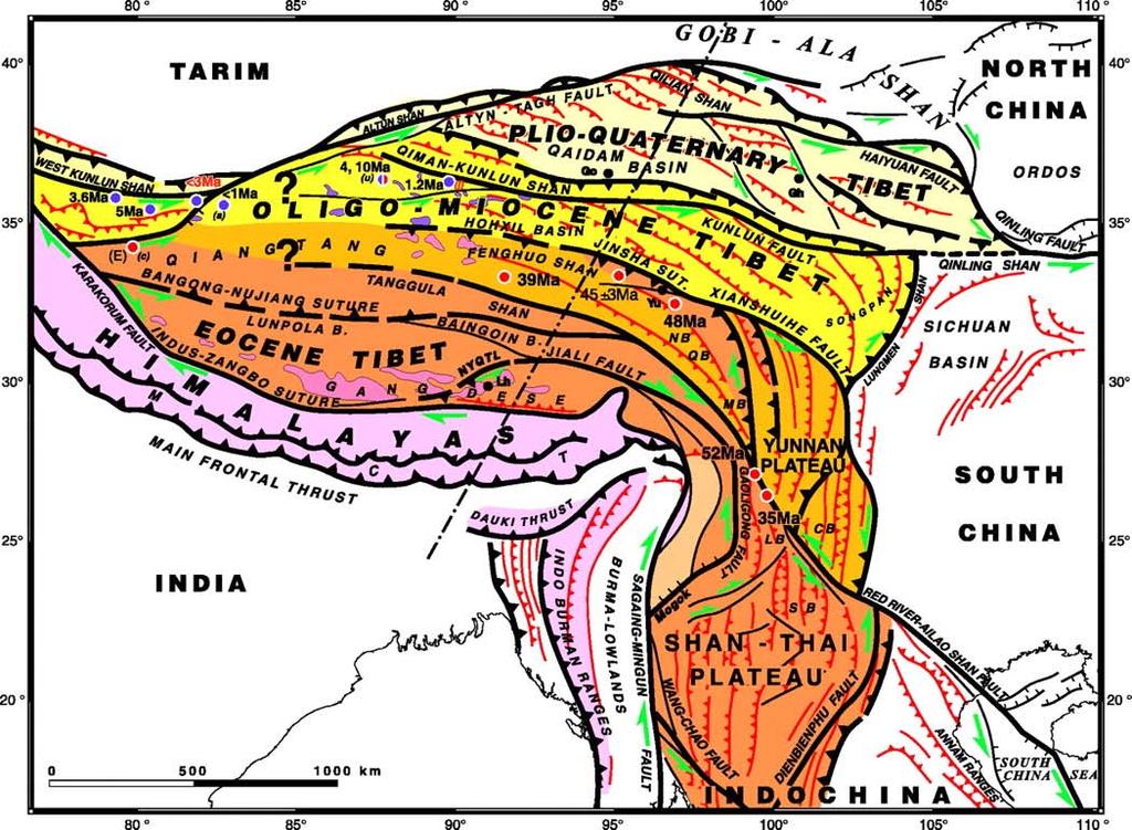
DEFORMATION KINEMATICS OF TIBETAN PLATEAU DETERMINED FROM GPS OBSERVATIONS
 DEFORMATION KINEMATICS OF TIBETAN PLATEAU DETERMINED FROM GPS OBSERVATIONS Jinwei Ren Institute of Geology, China Seismological Bureau, Beijing 100029 China Tel: (10)62009095; Fax: (10)62009003; email:
Introduction To Plate Tectonics Evolution. (Continents, Ocean Basins, Mountains and Continental Margins)
") Introduction To Plate Tectonics Evolution (Continents, Ocean Basins, Mountains and Continental Margins) Geo 386 (Arabian Shield Course) Dr. Bassam A. A. Abuamarah Mohanna G E O 3 8 6 A R A B I A N G E
Introduction To Plate Tectonics Evolution (Continents, Ocean Basins, Mountains and Continental Margins) Geo 386 (Arabian Shield Course) Dr. Bassam A. A. Abuamarah Mohanna G E O 3 8 6 A R A B I A N G E
Global Tectonics. Kearey, Philip. Table of Contents ISBN-13: Historical perspective. 2. The interior of the Earth.
 Global Tectonics Kearey, Philip ISBN-13: 9781405107778 Table of Contents Preface. Acknowledgments. 1. Historical perspective. 1.1 Continental drift. 1.2 Sea floor spreading and the birth of plate tectonics.
Crustal Activity. Plate Tectonics - Plates - Lithosphere - Asthenosphere - Earth s surface consists of a major plates and some minor ones
 Name: Date: Period: Tectonics The Physical Setting: Earth Science CLASS NOTES Tectonics - s - Lithosphere - Asthenosphere - Earth s surface consists of a major plates and some minor ones The plates are
Continental Drift and Plate Tectonics
 Continental Drift and Plate Tectonics Continental Drift Wegener s continental drift hypothesis stated that the continents had once been joined to form a single supercontinent. Wegener proposed that the
Evidence from the Surface. Chapter 02. Continental Drift. Fossil Evidence for Pangaea. Seafloor Spreading. Seafloor Spreading 1/31/2012
 Evidence from the Surface Surface landforms Continental shelf and slope Abyssal Plane Mid-oceanic ridge Oceanic Trenches Chapter 02 Continental Drift Continental Drift - a hypothesis that the continents
Geology 300, Physical Geology Spring 2019 Quiz Ch 19, Plate Tectonics Name
 Geology 300, Physical Geology Spring 2019 Quiz Ch 19, Plate Tectonics Name MULTIPLE CHOICE. Choose the one alternative that best completes the statement or answers the question. 1) The portion of a fracture
Plate Tectonics. The Theory of Plate Tectonics. The Plate Tectonics Theory. 62 Plate Tectonics Reading Essentials
 CHAPTER 4 LESSON 3 Tectonics The Theory of Tectonics Key Concepts What is the theory of plate tectonics? What are the three types of plate boundaries? Why do tectonic plates move? What do you think? Read
OCN 201: Seafloor Spreading and Plate Tectonics I
 OCN 201: Seafloor Spreading and Plate Tectonics I Revival of Continental Drift Theory Kiyoo Wadati (1935) speculated that earthquakes and volcanoes may be associated with continental drift. Hugo Benioff
Continental Drift. & Plate Tectonics
 Continental Drift & Plate Tectonics Alfred Wegener, a German scientist, proposed the hypothesis of CONTINENTAL DRIFT, in 1912. Hypothesis stated: All Earth s continents were once a single landmass (Pangaea)
Looking at the world map, what do you notice about the shape of the continents? Jot down your ideas on your paper
 Looking at the world map, what do you notice about the shape of the continents? Jot down your ideas on your paper The thing is the world didn t always look like this! It used to look like this: How is
Evolution of Continents Chapter 20
 Evolution of Continents Chapter 20 Does not contain complete lecture notes. Mountain belts Orogenesis the processes that collectively produce a mountain belt Includes folding, thrust faulting, metamorphism,
Earth Movement and Resultant Landforms
 Earth Movement and Resultant Landforms Structure of the Earth Lithosphere : earth s crust Asthenosphere : upper mantle zone where material is near its melting point & acts almost like liquid (appprox.
GCSE Geology Plate Tectonics: Features and Processes
 GCSE Geology Plate Tectonics: Features and Processes A) DIVERGENT BOUNDARIES: 1. O-O Divergence, Example: The Mid-Atlantic Ridge, Iceland The North American and Eurasian Plates are moving away from each
Plate Tectonics Unit II: Plate Boundaries (3.5 pts)
") T. James Noyes, El Camino College Plate Tectonics Unit II: The Plate Boundaries (Topic 11A-2) page 1 Name: Section: Plate Tectonics Unit II: Plate Boundaries (3.5 pts) Plate Boundaries We will now discuss
T. James Noyes, El Camino College Plate Tectonics Unit II: The Plate Boundaries (Topic 11A-2) page 1 Name: Section: Plate Tectonics Unit II: Plate Boundaries (3.5 pts) Plate Boundaries We will now discuss
 Sedimentary Basin Analysis http://eqsun.geo.arizona.edu/geo5xx/geos517/ Sedimentary basins can be classified based on the type of plate motions (divergent, convergent), type of the lithosphere, distance
North America subducted under Rubia. Are there modern analogs for Hildebrand s model of North America subducting under Rubia?
 North America subducted under Rubia Are there modern analogs for Hildebrand s model of North America subducting under Rubia? In the Geological Society of America Special Papers Did Westward Subduction
Forces That Shape Earth. How do continents move? What forces can change rocks? How does plate motion affect the rock cycle?
 Forces That Shape Earth How do continents move? What forces can change rocks? How does plate motion affect the rock cycle? Plate Motion Mountain ranges are produced by plate tectonics. The theory of plate
The Theory of Plate Tectonics
 Plate Tectonics Objectives Describe how plates move. Explain the features of plate tectonics. Describe the types of plate boundaries and the features that can form and events that can occur at each. The
PHYSICAL GEOLOGY AND THE ENVIRONMENT (2 ND CANADIAN EDITION)
") Chapter 2: Plate Tectonics Chapter Summary: Plate tectonics is a theory that suggests Earth's surface is divided into several large plates that change position and size. Intense geologic activity occurs
Chapter 2: Plate Tectonics Chapter Summary: Plate tectonics is a theory that suggests Earth's surface is divided into several large plates that change position and size. Intense geologic activity occurs
5/24/2018. Plate Tectonics. A Scientific Revolution Unfolds
 1 Plate Tectonics A Scientific Revolution Unfolds 2 3 4 5 6 7 8 9 10 11 12 Chapter 2 Plate Tectonics From Continental Drift to Plate Tectonics Prior to the late 1960s, most geologists believed that the
Module 7: Plate Tectonics and Earth's Structure Topic 2 Content: Plates of the World Presentation Notes
 There are several large plates and several smaller plates that comprise the Earth s crust. How do these plates interact with the bordering plates? Review each of the world s plates and the landforms that
83% 25 of 30 Correct. Dynamic Earth Assessment Test Results. Name: Marc Sto. Domingo Date: October 2, 2013
 Dynamic Earth Assessment Test Results Name: Marc Sto. Domingo Date: October 2, 2013 83% 25 of 30 Correct Review the questions and your answers below. The answer you selected is highlighted in red, the
From Earthquakes to Mountains: the Earth s Crust in Motion
 Dean s Freshman Honor Seminar (SCI 110) Eric Calais Associate Professor of Geophysics Purdue University Department of Earth and Atmospheric Sciences ecalais@purdue.edu http:/www.eas.purdue.edu/~calais
Section 2: How Mountains Form
 Section 2: How Mountains Form Preview Objectives Mountain Ranges and Systems Plate Tectonics and Mountains Types of Mountains Objectives Identify the types of plate collisions that form mountains. Identify
Lab 1: Plate Tectonics April 2, 2009
 Name: Lab 1: Plate Tectonics April 2, 2009 Objective: Students will be introduced to the theory of plate tectonics and different styles of plate margins and interactions. Introduction The planet can be
Plates Moving Apart Types of Boundaries
 Plates Moving Apart Types of Boundaries PLATE TECTONICS IS The theory that the Earth s crust is broken into slabs of rock that move around on top of the asthenosphere. How fast are plates moving? The Arctic
Captain s Tryouts 2017
 Captain s Tryouts 2017 Dynamic Planet Test Written by: Araneesh Pratap (Chattahoochee High School) Name: Date: Answer all questions on the answer sheet. Point values are given next to each question or
The continental lithosphere
 Simplicity to complexity: The continental lithosphere Reading: Fowler p350-377 Sampling techniques Seismic refraction Bulk crustal properties, thickness velocity profiles Seismic reflection To image specific
Shape Earth. Plate Boundaries. Building. Building
 Chapter Introduction Lesson 1 Lesson 2 Lesson 3 Lesson 4 Chapter Wrap-Up Forces That Shape Earth Landforms at Plate Boundaries Mountain Building Continent Building How is Earth s surface shaped by plate
Beneath our Feet: The 4 Layers of the Earty by Kelly Hashway
 Beneath our Feet: The 4 Layers of the Earty by Kelly Hashway The Earth is more than a giant ball made up of dirt, rocks, and minerals. The Earth may look like a giant ball from when looking at it from
Practice Questions: Plate Tectonics
 Practice Questions: Plate Tectonics 1. Base your answer to the following question on The block diagram below shows the boundary between two tectonic plates. Which type of plate boundary is shown? A) divergent
60% water. Big Bang: 14,000 millions years ago The Earth originated about 4,500 millions years ago its orbit allows water to exist in a liquid state!
 Ch2. The Sea Floor #1 Why geology of the oceans? Marine habitats are directly shaped by geological processes The form of the coastlines The depth of the water Type of bottom (muddy, sandy, rocky) #2 Geological
PLATE TECTONICS. Continental Drift. Continental Drift. Continental Drift. Continental Drift- Wegener s Evidence
 Continental Drift PLATE TECTONICS E.B. Taylor (1910) and Alfred Wegener (1915) published on Continental Drift. Continental Drift Wegener s evidence 1. Fit of the Continents 2. Fossil Evidence 3. Rock Type
FORCES ON EARTH. An investigation into how Newton s Laws of Motion are applied to the tectonic activity on Earth.
 FORCES ON EARTH An investigation into how Newton s Laws of Motion are applied to the tectonic activity on Earth. GEOLOGY Geologists scientists who study the forces that make and shape the Earth Geologists
Alfred Wegener gave us Continental Drift. Fifty years later...
 CHAPTER 2 Plate Tectonics and the Ocean Floor Plate Tectonics: summary in haiku form Alfred Wegener gave us Continental Drift. Fifty years later... Words Chapter Overview Much evidence supports plate tectonics
UNIT 11 PLATE TECTONICS
 UNIT 11 PLATE TECTONICS A. ALFRED WEGENER 1. Continental drift hypothesis Single supercontinent called Pangaea 200 million years ago Pangaea (all land) began to break up and started drifting to their present
Chapter 4: Plate Tectonics
 Chapter 4: Plate Tectonics K2 in the Himalaya, inset round submersible (beneath the submarine) that went to the Marianas Trench in 1960 http://www.nydailynews.com/news/world/james-cameron-presents-record-setting-deep-sea-expedition-article-1.1215139
Unit 11: Plate Tectonics
 Unit 11: Plate Tectonics A. Alfred Wegner 1. Continental drift hypothesis a. single supercontinent called Pangaea b. 200 million years ago Pangaea (all land) began to break up and started drifting to their
Whole Earth Structure and Plate Tectonics
 Whole Earth Structure and Plate Tectonics Processes in Structural Geology & Tectonics Ben van der Pluijm WW Norton+Authors, unless noted otherwise 4/5/2017 14:45 We Discuss Whole Earth Structure and Plate
OBJECTIVE: For each boundary type, give an example of where they occur on Earth.
 OBJECTIVE: Explain the theory of Plate Tectonics. COMPARE AND CONTRAST DIVERGENT, CONVERGENT AND TRANSFORM BOUNDARIES. ***very important. Describe what geologic features form at each of the three CONVERGENT
Plate Tectonics. By Destiny, Jarrek, Kaidence, and Autumn
 Plate Tectonics By Destiny, Jarrek, Kaidence, and Autumn .The Denali Fault and San Andreas Fault - The San Andreas Fault is a continental transform fault that extends roughly 1300 km (810 miles) through
Essentials of Oceanography Eleventh Edition
 Chapter Chapter 1 2 Clickers Lecture Essentials of Oceanography Eleventh Edition Plate Tectonics and the Ocean Floor Alan P. Trujillo Harold V. Thurman Chapter Overview Much evidence supports plate tectonics
Plate Tectonics: A Scientific Revolution Unfolds
 Chapter 2 Lecture Earth: An Introduction to Physical Geology Eleventh Edition Plate Tectonics: A Scientific Revolution Unfolds Tarbuck and Lutgens From Continental Drift to Plate Tectonics Prior to the
Introduction to Oceanography. Chapter 2: Plate Tectonics Overview
 Introduction to Oceanography Chapter 2: Plate Tectonics Overview Much evidence supports plate tectonics theory. The plate tectonics model describes features and processes on Earth. Plate tectonic science
FORCES ON EARTH UNIT 3.2. An investigation into how Newton s Laws of Motion are applied to the tectonic activity on Earth.
 FORCES ON EARTH UNIT 3.2 An investigation into how Newton s Laws of Motion are applied to the tectonic activity on Earth. USE THESE NOTES: OUR HOME PLANET EARTH: What do you know about our planet? SO.HOW
Plate Tectonics. Structure of the Earth
 Plate Tectonics Structure of the Earth The Earth can be considered as being made up of a series of concentric spheres, each made up of materials that differ in terms of composition and mechanical properties.
Earth Dynamics. Landforms at Plate Boundaries
 Earth Dynamics CHAPTER 8 LESSON 2 Landforms at Boundaries What do you think? Read the two statements below and decide whether you agree or disagree with them. Place an A in the Before column if you agree
The Four Layers The Earth is composed of four different layers. The crust is the layer that you live on, and it is the most widely studied and
 Earth s Structure The Four Layers The Earth is composed of four different layers. The crust is the layer that you live on, and it is the most widely studied and understood. The mantle is much hotter and
Plate Tectonics. Theory of Plate Tectonics. What is Plate Tectonics. Plate Tectonics Plate Boundaries Causes of Plate Tectonics
 Theory of Plate Tectonics Plate Tectonics Plate Boundaries Causes of Plate Tectonics Plate Tectonics What is Plate Tectonics The Earth s crust and upper mantle are broken into sections called plates Plates
Learning Objectives (LO)! Lecture 11: Plate Tectonics II! No Homework!! ** Chapter 3 **! What we ll learn today:!
! Lecture 11: Plate Tectonics II! No Homework!! ** Chapter 3 **! What we ll learn today:!") Learning Objectives (LO)! Lecture 11: Plate Tectonics II! No Homework!! ** Chapter 3 **! What we ll learn today:! 1. List the three types of tectonic plate boundaries! 2. Describe the processes occurring
Learning Objectives (LO)! Lecture 11: Plate Tectonics II! No Homework!! ** Chapter 3 **! What we ll learn today:! 1. List the three types of tectonic plate boundaries! 2. Describe the processes occurring
Plate Tectonics. I. The Discovery of Plate Tectonics II. A Mosaic of Plates III. Types of Plate Boundaries IV. How Plates Move
 Plate Tectonics I. The Discovery of Plate Tectonics II. A Mosaic of Plates III. Types of Plate Boundaries IV. How Plates Move I. The Discovery of Plate Tectonics A. Continental Drift (Alfred Wegener) Proposed
Plate Tectonics. Goal 2.1
 Plate Tectonics Goal 2.1 Lesson 1 Plate Tectonics: An Overview Think About It Look at the map below. Which two continents look like they d fit together? Focus Question How do Earth s tectonic plates cause
OCN 201 Seafloor Spreading and Plate Tectonics. Question
 OCN 201 Seafloor Spreading and Plate Tectonics Question What was wrong from Wegener s theory of continental drift? A. The continents were once all connected in a single supercontinent B. The continents
Questions and Topics
 Plate Tectonics and Continental Drift Questions and Topics 1. What are the theories of Plate Tectonics and Continental Drift? 2. What is the evidence that Continents move? 3. What are the forces that
Movement of the Earth s Crust: Formation of: Mountain s Plateau's and Dome s
 Movement of the Earth s Crust: Formation of: Mountain s Plateau's and Dome s References Information taken from several places including Prentice Hall Earth Science: @ http://www.eram.k12.ny.us/education/components/docmgr/default.php?sectiondetaili
Mountains are then built by deforming crust: Deformation & Mountain Building. Mountains form where stresses are high!
 Deformation & Mountain Building Where are mountains located? Deformation and Folding Mountain building Mountains form where stresses are high! Mountains form at all three types of plate boundaries where
The Structure of the Earth and Plate Tectonics
 The Structure of the Earth and Plate Tectonics Agree or Disagree? 1. The Earth if made up of 4 different layers. 2. The crust (where we live) can be made of either less dense continental crust or the more
1. occurs when the oceanic crust slides under the continental crust.
 1. occurs when the oceanic crust slides under the continental crust. 2. What type of stress is shown? 3. Where two plates slide past one another is called a boundary. 4. What type of stress is shown? 5.
Plate Tectonics. In 1912 Alfred Wegener ( ) proposed that: the continents were once compressed into a single protocontinent which he called
 proposed that: the continents were once compressed into a single protocontinent which he called") Plate Tectonics In 1912 Alfred Wegener (1880-1930) proposed that: the continents were once compressed into a single protocontinent which he called Pangaea (meaning "all lands"), and over time they have
Plate Tectonics In 1912 Alfred Wegener (1880-1930) proposed that: the continents were once compressed into a single protocontinent which he called Pangaea (meaning "all lands"), and over time they have
An Introduction to the Seafloor and Plate Tectonics 1
 An Introduction to the Seafloor and Plate Tectonics 1 Objectives 1) Investigate the components of the lithosphere and lithospheric plates. 2) Identify the associations among various seafloor features,
Plate Tectonics Practice Test
 Plate Tectonics Practice Test 1. What is the main idea Alfred Wegner proposed in the Theory of Continental Drift that he published in 1915? a. The continents float on a liquid layer that allows them to
1. What is Wegener s theory of continental drift? 2. What were the 4 evidences supporting his theory? 3. Why wasn t Wegener s theory excepted?
 Notebook 7a and 7b Objective (left-side): Students will be able to explain the theory of plate tectonics and be able to make predictions about plate interactions. Mapping Reflection 1. What is Wegener
Layer Composition Thickness State of Matter
 Unit 4.2 Test Review Earth and Its Layers 1. Label the layers of the earth. oceanic crust continental crust lithosphere asthenosphere mantle outer core inner core 2. Complete the Following Table about
12/3/2014. Plate Tectonics: A Scientific Revolution Unfolds Earth Science, 13e Chapter 7. Continental drift: an idea before its time
 Plate Tectonics: A Scientific Revolution Unfolds Earth Science, 13e Chapter 7 Stanley C. Hatfield Southwestern Illinois College Continental drift: an idea before its time Alfred Wegener First proposed
Convergent plate boundaries. Objective to be able to explain the formation and key features of these zones.
 Convergent plate boundaries Objective to be able to explain the formation and key features of these zones. Destructive plate margins When plates collide due to convection currents/slab pull in the asthenosphere
Plate Tectonics. Earth has distinctive layers - Like an onion
 Plate Tectonics Earth has distinctive layers - Like an onion Earth s Interior Core: Metallic (Iron, Nickel) Inner (hot, solid, dense, Iron, Nickel) Outer (cooler, liquid, less dense) Crust (outermost layer):