Uplift of the Longmen Shan and Tibetan plateau, and the 2008 Wenchuan (M=7.9) earthquake
|
|
|
- Hilary Montgomery
- 5 years ago
- Views:
Transcription
1 Uplift of the Longmen Shan and Tibetan plateau, and the 2008 Wenchuan (M=7.9) earthquake Judith Hubbard 1,* & John H. Shaw 1 1 Department of Earth and Planetary Sciences, Harvard University, 20 Oxford Street, Cambridge, Massachusetts 02138, USA. *Corresponding author. jhubbard@fas.harvard.edu Abstract The Longmen Shan mountain range, site of the devastating 12 May 2008 Wenchuan (M=7.9) earthquake, defines the eastern margin of the Himalayan orogen and exhibits greater topographic relief than anywhere else in the Tibetan plateau. However, before the earthquake, geodetic and geologic surveys measured little shortening across the range front 1 3, inspiring a vigorous debate about the process by which the topography of the mountain belt is produced and maintained. Two endmember models have been proposed: (1) brittle crustal thickening, in which thrust faults with large amounts of slip that are rooted in the lithosphere cause uplift 4, and (2) crustal flow, in which low-viscosity material in the lower crust extrudes outward from the Tibetan plateau and inflates the crust north and east of the Himalayas 5 7. Here we use balanced geologic cross-sections to show that crustal shortening, structural relief, and topography are strongly correlated in the range front. This suggests that crustal shortening is a primary driver for uplift and topography of the Longmen Shan on the flanks of the plateau. The 2008 Wenchuan (M=7.9) earthquake, which ruptured a large thrust fault along the range front causing tens of thousands of fatalities and widespread damage, is an active manifestation of this shortening process. India began colliding with Eurasia over 50 million years ago, progressively accommodating at least 1,400km of north south shortening 8. This plate collision uplifted the highest mountains in the world and also a vast flat region to the
2 north known as the Tibetan plateau. This plateau has an average elevation of over 5,000 m, maintained in part by a km-thick crust with a complex and heterogeneous three-dimensional structure inferred from tomographic studies On the eastern side of the Tibetan plateau, the Longmen Shan rise 6,000 m above the Sichuan basin, exhibiting greater relief than anywhere else on the plateau (Fig. 1). Exhumation rates suggest that the relief has formed since the Miocene epoch 12. However, geodetic measurements 1 3 and geomorphic observations 13 generally agree that east west shortening across the range and within the basin is very limited (<3 mm yr 1 ). Moreover, the Longmen Shan lacks a typical foreland basin, a depression caused by plate loading that typically occurs in front of fold-and-thrust belts 14,15. As a result, basic and controversial questions persist about how this relief was created and is sustained, fuelling debate about how the broader Tibetan plateau was formed. Are the mountains formed by crustal faulting and shortening 4, or are they maintained by dynamic pressure from lower-crustal flow 5 7? The second hypothesis argues that lower-crustal material flowing outward from the centre of the plateau is buttressed by the old, strong lithosphere that underlies the Sichuan basin, pushing up on the crust above and maintaining steep topography through dynamic pressure. This model requires no substantial horizontal shortening at the surface, because the upper crust is largely uplifted, but not laterally displaced, by the lower-crustal motion 16. (Fig. 2) An important distinction between these two models is that brittle crustal thickening requires horizontal shortening to be related to vertical uplift in the Longmen Shan, whereas lower-crustal flow suggests that the two are largely decoupled 16,17. Here we aim to quantify past horizontal shortening on the eastern border of the Longmen Shan to determine whether the gradient in horizontal shortening reflects the current topography. Measures of horizontal shortening are derived from structural interpretation of industry seismic reflection profiles and surface geology in the Sichuan basin and the foothills of the Longmen Shan. Substantial amounts of industry seismic reflection data have been acquired since the 1980s in the Sichuan basin and eastern Longmen Shan to identify petroleum traps; these data offer clear images of faults and related folds in the upper crust (see Supplementary Figs 1 and 2). The lines are supported by a number of wells
3 providing chrono-stratigraphic control on the subsurface geology. We use quantitative fault-related folding techniques to interpret these data and construct balanced, retrodeformable cross-sections 18,19. These balanced sections provide direct measures of shortening and uplift, which we examine in conjunction with topography across the range front. Deformation in the southwestern Sichuan basin can be separated into six northeast southwest-striking domains, visible in both the seismic data and satellite images of the surface (Fig. 1). From east to west, these are (1) a set of broad folds, hereafter referred to as the Zigong folds after a city in their vicinity, (2) the Weiyuan anticline, (3) the Longqan anticline, (4) the Emei anticline, (5) the Xiong Po anticline, and (6) the Longmenshan foothills (Fig. 3b). In addition, the strata exhibit a regional west dip of two to three degrees towards the Longmen Shan west of the Weiyuan structure. This dip may be related to loading of the crust by the mountain belt. However, it lacks the typical expression of a foreland basin, perhaps due to the lack of synorogenic sediments, which are not present in the basin. The six major structural trends are formed by fault-bend or fault-propagation folds rooted in detachments that transfer shortening from the mountain belt towards the east into the Sichuan basin. From the seismic reflection data, we identify three detachment levels, which define the base of the thrust sheets: a shallow detachment 3 5 km below the surface, an intermediate detachment 5 7 km below the surface, and a deep detachment at least 15km deep on the northwestern side of the lines, shallowing to no less than 6 km to the southeast. Each detachment feeds slip onto thrust ramps that produce upper crustal shortening and uplift the range front of the Longmen Shan. The amounts of slip interpreted on the thrust ramps and detachments are constrained by the offsets of hanging-wall and footwall cut-offs of stratigraphic horizons, as well as the shapes of associated fault-related folds. We focus our discussion of shortening and structural relief on a regional structural transect (lines A A in Fig. 1) that represents the general style of deformation along the range front. The total shortening measured by line length on the six structures totals ~ 25.8 km, with most taken up across the Longmenshan foothills (13.3 km) and the Xiong Po backthrust ( ~ 7.4km), the structures closest to the range front. The Emei, Longqan, Weiyuan and Zigong structures account for 1.0, 1.1, 1.1 and 1.9
4 km of shortening, respectively. To determine the gradient of shortening, we calculate the percentage shortening for each structural trend. Crustal shortening is defined as the amount of northwest-tosoutheast contraction that has occurred across each of the six major structural domains as the result of folding and faulting. The shortening measurements vary from about 2% up to 40%, and dramatically increase upon approaching and entering the Longmen Shan. This westward increase in crustal shortening directly corresponds with the rapidly increasing elevations of the range front, suggesting that brittle shortening is closely linked to producing and maintaining the topography of the mountain belt (Table 1 and Fig. 3a). In addition, we calculate profiles of structural relief along lines A A and compare them with topography (Fig. 3c). Structural relief records the total uplift produced by each fault and fold trend in the basin, and thus is considered to be another measure of upper crustal deformation. We quantify structural relief using the deformed shape of the youngest, pre-tectonic Jurassic stratigraphic horizon that is defined by continuous reflections in the industry seismic data. The patterns of structural relief correspond closely with the present-day topography observed along the range front. The magnitudes and gradients in topographic relief are clearly less than the structural relief due to erosion. Nevertheless, the positions of the maxima, minima and gradients in structural relief and topography closely correlate, implying that present-day topography is produced by uplift along faults and folds in the upper crust. We note that the Zigong folds, which represent the westernmost extent of the largely inactive Eastern Sichuan fold belt rather than deformation associated with the Longmen Shan, do not show this correlation. In summary, our quantitative interpretation of structures in the Sichuan basin and foothills of the Longmen Shan indicates that a large increase in shortening occurs upon approaching the range front. Moreover, structural relief produced by folds and faults is also closely correlated with, and sufficient in magnitude to explain, the topography of the range front. This implies that upper-crustal deformation, decoupled from the lower crust by a series of detachments, is the primary mechanism for generating uplift and topography in the foothills of the Longmen Shan. In the crustal shortening versus lower-crustal-flow debate, it is the range front s reported absence
5 of active shortening that underpins the lower-crustal-flow hypothesis, and some models proposed for this lower-crustal-flow process explicitly prescribe no correlation between upper-crustal shortening and topography 16. Thus, we interpret our results to obviate the need for lower-crustal flow and inflation to produce and maintain the Longmen Shan range front, and argue that if lower-crustal flow occurs in the interior of the mountain belt, it must somehow be directly coupled to upper-crustal deformation in the range front. Alternatively, further deepening of the active thrust systems and shortening west of our study area, which has been inferred in recent geodetic studies 14 and documented in geologic mapping 20, may account for uplift of the plateau in the absence of significant lower-crustal flow. The Wenchuan (M=7.9) earthquake is a direct manifestation of the active crustal shortening that we suggest produced and supports the Longmen Shan range front. This devastating earthquake occurred on a series of large, crustal thrust faults that form the range front and accommodate crustal shortening immediately west of the area we considered (Fig. 4). From the distribution of large aftershocks and reported surface ruptures, it appears that this earthquake and its aftershocks caused slip on two major faults within this imbricated thrust stack that ramp upward to the surface, as well as others that transfer slip over geologic timescales into the basin on the detachment surfaces documented here. Thus, the Wenchuan (M=7.9) earthquake documents the role of active crustal shortening in developing and supporting the Longmen Shan range front and the Tibetan plateau, consistent with the results of our analysis that relate crustal shortening to the development of range front topography. This earthquake also clearly illustrates the potential for large and very destructive events on similar active thrust faults that have been observed in other populated regions around the world. Acknowledgements We thank the reviewers, E. Kirby and J. Dolan, for their comments and suggestions. Texaco and the China National Petroleum Corporation provided the seismic data used in this project.
6 References 1. Shen, Z. K., Lu, J. N., Wang, M. & Burgmann, R. Contemporary crustal deformation around the southeast borderland of the Tibetan Plateau. J. Geophys. Res. 110, 11409, doi: /2004jb (2005). 2. Meade, B. J. Present-day kinematics at the India-Asia collision zone. Geology 35, (2007). 3. Chen, Z. et al. Global Positioning System measurements from eastern Tibet and their implications for India/Eurasia intercontinental deformation. J. Geophys. Res. 105, (2000). 4. Tapponnier, P. et al. Geology Oblique stepwise rise and growth of the Tibet plateau. Science 294, (2001). 5. Royden, L. H. et al. Surface deformation and lower crustal flow in eastern Tibet. Science 276, (1997). 6. Burchfiel, B. C presidential address: New technology, new geological challenges. GSA Today 14, 4 9 (2004). 7. Bird, P. Lateral extrusion of lower crust from under high topography, in the isostatic limit. J. Geophys. Res. 96, (1991). 8. Yin, A. & Harrison, T. M. Geologic evolution of the Himalayan-Tibetan orogen. Annu. Rev. Earth Planet. Sci. 28, (2000). 9. Rapine, R., Tilmann, F., West, M., Ni, J. & Rodgers, A. Crustal structure of northern and southern Tibet from surface wave dispersion analysis. J. Geophys. Res. 108, B22120, doi: /2001jb (2003). 10. Xu, L., Rondenay, S. & van der Hilst, R. D. Structure of the crust beneath the southeastern Tibetan Plateau from teleseismic receiver functions. Phys. Earth Planet. Inter. 165, (2007). 11. Yao, H., Behein, C. & van der Hilst, R. D. Surface wave array tomography in SE Tibet from ambient seismic noise and two-station analysis. II. Crustal and
7 upper-mantle structure. Geophys. J. Int. 173, (2008). 12. Kirby, E. et al. Late Cenozoic evolution of the eastern margin of the Tibetan Plateau: Inferences from 40 Ar/ 39 Ar and (U-Th)/He thermochronology. Tectonics 21 (1), 1001, doi: /2000tc (2002). 13. Densmore, A. L.et al. Active tectonics of the Beichuan and Pengguan faults at the eastern margin of the Tibetan Plateau. Tectonics 26, TC4005, doi: / 2006TC (2007). 14. Burchfiel, B. C. et al. A geological and geophysical context for the Wenchuan earthquake of 12 May 2008, Sichuan, People s Republic of China. GSA Today 18, 4 11 (2008). 15. Burchfiel, B. C. et al. Tectonics of the Longmen Shan and adjacent regions, Central China. Int. Geol. Rev. 37, (1995). 16. Clark, M. K., Bush, J. W. M. & Royden, L. H. Dynamic topography produced by lower crustal flow against rheological strength heterogeneities bordering the Tibetan Plateau. Geophys. J. Int. 162, (2005). 17. Medvedev, S. & Beaumont, C. in Channel Flow, Ductile Extrusion and Exhumation in Continental Collision Zones (eds Law, R. D., Searle, M. P. & Godin, L.) (Geological Society, London, 2006). 18. Shaw, J. H., Connors, C. & Suppe, J. Seismic Interpretation of Contractional Fault-related Folds: An AAPG Seismic Atlas 1-58 (AAPG, 2005). 19. Suppe, J. Geometry and kinematics of fault-bend folding. Am. J. Sci. 283, (1983). 20. Chen, S. F. & Wilson, C. J. L. Emplacement of the Longmen Shan Thrust- Nappe Belt along the eastern margin of the Tibetan Plateau. J. Struct. Geol. 18, (1996).
8 List of Table Table 1 Shortening measurements for each structure along line A A.
9 List of Figures Figure 1 Figure 2 Map of the Longmen Shan and western Sichuan basin, showing the epicentre and focal mechanism of the 2008 Wenchuan (M=7.9) earthquake, aftershocks, and major faults. A A and B B are cross-sections based on seismic reflection profiles used to characterize crustal deformation in this study. Emergent and blind thrusts are distinguished; faults in red are the Beichuan and Hanwang faults, which ruptured in the 2008 Wenchuan earthquake. Alternative conceptual models for the uplift of the Tibetan plateau and development of the Longmen Shan range front. Top panel, uplift is produced by thrust faulting and crustal shortening 4. Bottom panel, uplift is produced by inflation of the ductile lower crust 5 7. Figure 3 Comparison of crustal shortening and topography along line A A. See Table 1. a, Percentage shortening is shown as colour bars (alternating green and blue) plotted over topography; we note the dramatic increase in shortening towards the range front. b, Geologic cross-section. c, Topography (black) and structural relief (blue) from structural interpretation. Vertical dashed lines separate the Zigong folds from the rest of the line (see text). Figure 4 Geologic cross-section B B across the location of the 2008 Wenchuan (M=7.9) earthquake. On the basis of the depth and preferred nodal plane of the main shock, the earthquake and its aftershocks appear to have ruptured one or more imbricated thrust and reverse faults in the range front, including the Beichuan faults, of which there are reports of surface rupture. CMT indicates the Global CentroidMoment Tensor (CMT) Project ( Moment Tensor Solution. The Pengguan fault lies south of the Hanwang fault but did not rupture in the earthquake.
10 Table 1 Structure Shortening (m) Distance (km) Shortening (%) Foothills Xiong Po Emei Longqan Weiyuan Zigong The percentage shortening was calculated by dividing shortening by the horizontal width of each structural belt.
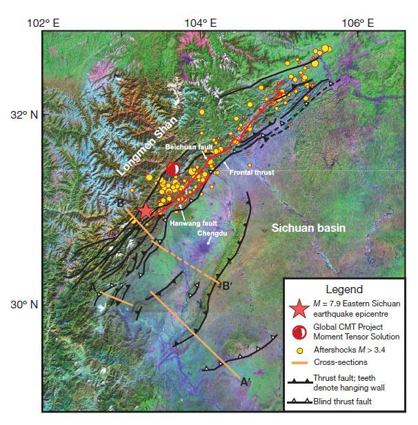
11 Figure 1
12 Figure 2
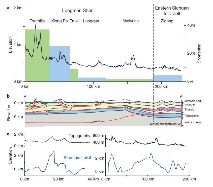
13 Figure 3
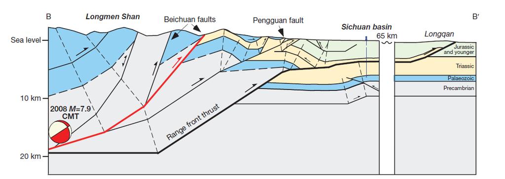
14 Figure 4
GEOPHYSICAL RESEARCH LETTERS, VOL. 37, L02304, doi: /2009gl041835, 2010
 Click Here for Full Article GEOPHYSICAL RESEARCH LETTERS, VOL. 37,, doi:10.1029/2009gl041835, 2010 Seismic structure of the Longmen Shan region from S wave tomography and its relationship with the Wenchuan
SCIENCE CHINA Earth Sciences
 SCIENCE CHINA Earth Sciences RESEARCH PAPER September 2011 Vol.54 No.9: 1386 1393 doi: 10.1007/s11430-011-4177-2 Crustal P-wave velocity structure of the Longmenshan region and its tectonic implications
Earth Science, (Tarbuck/Lutgens) Chapter 10: Mountain Building
 Chapter 10: Mountain Building") Earth Science, (Tarbuck/Lutgens) Chapter 10: Mountain Building 1) A(n) fault has little or no vertical movements of the two blocks. A) stick slip B) oblique slip C) strike slip D) dip slip 2) In a(n) fault,
Earth Science, (Tarbuck/Lutgens) Chapter 10: Mountain Building 1) A(n) fault has little or no vertical movements of the two blocks. A) stick slip B) oblique slip C) strike slip D) dip slip 2) In a(n) fault,
DEFORMATION KINEMATICS OF TIBETAN PLATEAU DETERMINED FROM GPS OBSERVATIONS
 DEFORMATION KINEMATICS OF TIBETAN PLATEAU DETERMINED FROM GPS OBSERVATIONS Jinwei Ren Institute of Geology, China Seismological Bureau, Beijing 100029 China Tel: (10)62009095; Fax: (10)62009003; email:
Global Tectonics. Kearey, Philip. Table of Contents ISBN-13: Historical perspective. 2. The interior of the Earth.
 Global Tectonics Kearey, Philip ISBN-13: 9781405107778 Table of Contents Preface. Acknowledgments. 1. Historical perspective. 1.1 Continental drift. 1.2 Sea floor spreading and the birth of plate tectonics.
Essentials of Geology, 11e
 Essentials of Geology, 11e Crustal Deformation and Mountain Building Chapter 17 Instructor Jennifer Barson Spokane Falls Community College Geology 101 Stanley Hatfield Southwestern Illinois College Jennifer
Deformation of Rocks. Orientation of Deformed Rocks
 Deformation of Rocks Folds and faults are geologic structures caused by deformation. Structural geology is the study of the deformation of rocks and its effects. Fig. 7.1 Orientation of Deformed Rocks
Is the deformation rate of the Longmenshan fault zone really small? Insight from seismic data at the two-decade time scale
 LETTER Earth Planets Space, 62, 887 891, 2010 Is the deformation rate of the Longmenshan fault zone really small? Insight from seismic data at the two-decade time scale Yizhe Zhao 1, Zhongliang Wu 1,2,
surface uplift of fault-related folds rely primarily on their limbs and associated
 Finite and Quaternary shortening calculation Finite shortening Models commonly used to constrain the structural evolution, shortening, and surface uplift of fault-related folds rely primarily on their
A viscoelastic model for time-dependent simulating analysis of the Wenchuan earthquake fault Cheng Hua, Jin Cheng and Qi-fu Chen
 Journal of Math-for-Industry, Vol. 4 (2012A-10), pp. 79 83 A viscoelastic model for time-dependent simulating analysis of the Wenchuan earthquake fault Cheng Hua, Jin Cheng and Qi-fu Chen Received on February
 Sedimentary Basin Analysis http://eqsun.geo.arizona.edu/geo5xx/geos517/ Sedimentary basins can be classified based on the type of plate motions (divergent, convergent), type of the lithosphere, distance
Crustal Uplift in the Longmen Shan Mountains Revealed by Isostatic Gravity Anomalies along the Eastern Margin of the Tibetan Plateau
 Vol. 92 No. 1 pp.56 73 Feb. 2018 Crustal Uplift in the Longmen Shan Mountains Revealed by Isostatic Gravity Anomalies along the Eastern Margin of the Tibetan Plateau LI Yong 1, YAN Zhaokun 1, *, ZHOU Rongjun
Widespread Ground Motion Distribution Caused by Rupture Directivity during the 2015 Gorkha, Nepal Earthquake
 Widespread Ground Motion Distribution Caused by Rupture Directivity during the 2015 Gorkha, Nepal Earthquake Kazuki Koketsu 1, Hiroe Miyake 2, Srinagesh Davuluri 3 and Soma Nath Sapkota 4 1. Corresponding
Active Tectonics and Erosional Unloading at the Eastern Margin of the Tibetan Plateau
 Journal of Mountain Science Vol 2 No 2 (2005): 146~154 http://www.imde.ac.cn/journal Article ID: 1672-6316 (2005) 02-0146-09 Active Tectonics and Erosional Unloading at the Eastern Margin of the Tibetan
Lecture Outlines PowerPoint. Chapter 10 Earth Science, 12e Tarbuck/Lutgens
 Lecture Outlines PowerPoint Chapter 10 Earth Science, 12e Tarbuck/Lutgens 2009 Pearson Prentice Hall This work is protected by United States copyright laws and is provided solely for the use of instructors
Answers: Internal Processes and Structures (Isostasy)
") Answers: Internal Processes and Structures (Isostasy) 1. Analyse the adjustment of the crust to changes in loads associated with volcanism, mountain building, erosion, and glaciation by using the concept
Answers: Internal Processes and Structures (Isostasy) 1. Analyse the adjustment of the crust to changes in loads associated with volcanism, mountain building, erosion, and glaciation by using the concept
Plate Tectonics. entirely rock both and rock
 Plate Tectonics I. Tectonics A. Tectonic Forces are forces generated from within Earth causing rock to become. B. 1. The study of the origin and arrangement of Earth surface including mountain belts, continents,
USU 1360 TECTONICS / PROCESSES
 USU 1360 TECTONICS / PROCESSES Observe the world map and each enlargement Pacific Northwest Tibet South America Japan 03.00.a1 South Atlantic Arabian Peninsula Observe features near the Pacific Northwest
Relocation of aftershocks of the Wenchuan M S 8.0 earthquake and its implication to seismotectonics
 Earthq Sci (2011)24: 107 113 107 doi:10.1007/s11589-011-0774-6 Relocation of aftershocks of the Wenchuan M S 8.0 earthquake and its implication to seismotectonics Bo Zhao Yutao Shi and Yuan Gao Institute
Specific gravity field and deep crustal structure of the Himalayas east structural knot
 49 4 2006 7 CHINESE JOURNAL OF GEOPHYSICS Vol. 49, No. 4 Jul., 2006,,.., 2006, 49 (4) :1045 1052 Teng J W, Wang Q S, Wang GJ, et al. Specific gravity field and deep crustal structure of the Himalayas east
Description of faults
 GLG310 Structural Geology Description of faults Horizontal stretch Crustal thickness Regional elevation Regional character Issues Normal Thrust/reverse Strike-slip >1 1 in one direction and < 1 in
Learning Objectives (LO) What we ll learn today:!
 What we ll learn today:!") Learning Objectives (LO) Lecture 13: Mountain Building Read: Chapter 10 Homework #11 due Tuesday 12pm What we ll learn today:! 1. Define the types of stress that are present in the crust! 2. Define the
Learning Objectives (LO) Lecture 13: Mountain Building Read: Chapter 10 Homework #11 due Tuesday 12pm What we ll learn today:! 1. Define the types of stress that are present in the crust! 2. Define the
Mountains and Mountain Building: Chapter 11
 Mountains and Mountain Building: Chapter 11 Objectives: 1)Explain how some of Earth s major mountain belts formed 2) Compare and contrast active and passive continental margins 3) Explain how compression,
The Quaternary Dextral Shearing in the Southeastern. Tibetan Plateau
 The Quaternary Dextral Shearing in the Southeastern Tibetan Plateau SHEN Jun Wang Yipeng REN Jinwei CAO Zhongquan Institute of Geology of China Seismological Bureau, Beijing 100029, China Tel:8610-62009121,
Mantle anisotropy across the southwestern boundary of the Ordos block, North China
 Earthq Sci (200)23: 549 553 549 Doi: 0.007/s589-00-0754-2 Mantle anisotropy across the southwestern boundary of the Ordos block, North China, Yongcai Tang Yongshun John Chen Yuanyuan V. Fu 2 Haiyang Wang
Crags, Cracks, and Crumples: Crustal Deformation and Mountain Building
 Crags, Cracks, and Crumples: Crustal Deformation and Mountain Building Updated by: Rick Oches, Professor of Geology & Environmental Sciences Bentley University Waltham, Massachusetts Based on slides prepared
Gondwana Research. Numerical modeling of eastern Tibetan-type margin: Influences of surface processes, lithospheric structure and crustal rheology
 Gondwana Research (13) 191 117 Contents lists available at ScienceDirect Gondwana Research journal homepage: www.elsevier.com/locate/gr Numerical modeling of eastern Tibetan-type margin: Influences of
Evolution of Continents Chapter 20
 Evolution of Continents Chapter 20 Does not contain complete lecture notes. Mountain belts Orogenesis the processes that collectively produce a mountain belt Includes folding, thrust faulting, metamorphism,
Structural Geology of the Mountains
 Structural Geology of the Mountains Clinton R. Tippett Shell Canada Limited, Calgary, Alberta clinton.tippett@shell.ca INTRODUCTION The Southern Rocky Mountains of Canada (Figure 1) are made up of several
Geologic Structures. Changes in the shape and/or orientation of rocks in response to applied stress
 Geologic Structures Changes in the shape and/or orientation of rocks in response to applied stress Figure 15.19 Can be as big as a breadbox Or much bigger than a breadbox Three basic types Fractures >>>
Directed Reading. Section: How Mountains Form MOUNTAIN RANGES AND SYSTEMS. Skills Worksheet
 Skills Worksheet Directed Reading Section: How Mountains Form 1. How high is Mount Everest? a. about 1980 km above sea level b. more than 8 km below sea level c. more than 8 km above sea level d. more
Chapter. Mountain Building
 Chapter Mountain Building 11.1 Rock Deformation Factors Affecting Deformation Factors that influence the strength of a rock and how it will deform include temperature, confining pressure, rock type, and
Three-dimensional numerical simulation on the coseismic deformation of the 2008 M S 8.0 Wenchuan earthquake in China
 Earthq Sci (2010)23: 191 200 191 Doi: 10.1007/s11589-009-0091-5 Three-dimensional numerical simulation on the coseismic deformation of the 2008 M S 8.0 Wenchuan earthquake in China Feng Li and Jinshui
Mapping the deep lithospheric structure beneath the eastern margin of the Tibetan Plateau from gravity anomalies
 JOURNAL OF GEOPHYSICAL RESEARCH, VOL. 110,, doi:10.1029/2004jb003394, 2005 Mapping the deep lithospheric structure beneath the eastern margin of the Tibetan Plateau from gravity anomalies Xiaodian Jiang
Strike-Slip Faults. ! Fault motion is parallel to the strike of the fault.
 Strike-Slip Faults! Fault motion is parallel to the strike of the fault.! Usually vertical, no hanging-wall/footwall blocks.! Classified by the relative sense of motion. " Right lateral opposite block
How to Build a Mountain and other Geologic Structures. But first a short review
 How to Build a Mountain and other Geologic Structures But first a short review Where do we see deep earthquakes? What is happening there? What can happen at a plate boundary? 1. Plates can move apart
The continental lithosphere
 Simplicity to complexity: The continental lithosphere Reading: Fowler p350-377 Sampling techniques Seismic refraction Bulk crustal properties, thickness velocity profiles Seismic reflection To image specific
KEY CHAPTER 12 TAKE-HOME QUIZ INTERNAL STRUCTURES AND PROCESSES Score Part B = / 55 PART B
 GEOLOGY 12 KEY CHAPTER 12 TAKE-HOME QUIZ INTERNAL STRUCTURES AND PROCESSES Score Part B = / 55 PART B CHAPTER 12 Isostacy and Structural Geology 1. Using the terms below, label the following diagrams and
John Shaw CRUSTAL DEFORMATION MODEL: OBLIQUE CONVERGENCE IN THE INNER CALIFORNIA BORDERLANDS ACCOMMODATED BY ACTIVE STRIKE-SLIP AND REVERSE FAULTS
 CRUSTAL DEFORMATION MODEL: OBLIQUE CONVERGENCE IN THE INNER CALIFORNIA BORDERLANDS ACCOMMODATED BY ACTIVE STRIKE-SLIP AND REVERSE FAULTS August 2013 SONGS SSC SSHAC Workshop # 2 (August 12-14, 2013) Crustal
Copyright McGraw-Hill Education. All rights reserved. No reproduction or distribution without the prior written consent of McGraw-Hill Education
 Copyright McGraw-Hill Education. All rights reserved. No reproduction or distribution without the prior written consent of McGraw-Hill Education Tibetan Plateau and Himalaya -southern Asia 11.00.a VE 10X
NATURAL ENVIRONMENT. Geophysics
 NATURAL ENVIRONMENT Geophysics Geodynamics Alpine, Carpathian and Dinaric mountain belts surround the Pannonian (Carpathian) Basin, of Neogene through Quaternary in age. The Cenozoic evolution of the Alpine-Pannonian
CRUSTAL DEFORMATION. Chapter 10
 CRUSTAL DEFORMATION and dgeologic Structures t Chapter 10 Deformation Df Deformation involves: Stress the amount of force applied to a given area. Types of Stress: Confining Stress stress applied equally
Structural Styles and Geotectonic Elements in Northwestern Mississippi: Interpreted from Gravity, Magnetic, and Proprietary 2D Seismic Data
 Structural Styles and Geotectonic Elements in Northwestern Mississippi: Interpreted from Gravity, Magnetic, and Proprietary 2D Seismic Data Nick Loundagin 1 and Gary L. Kinsland 2 1 6573 W. Euclid Pl.,
SHORT RESEARCH. Limit of channel flow in orogenic plateaux. L 114 1st pages / 1 of 5. Patrice F. Rey 1, Christian Teyssier 2, and Donna L.
 SHORT RESEARCH Limit of channel flow in orogenic plateaux Patrice F. Rey, Christian Teyssier, and Donna L. Whitney EARTHBYTE GROUP, SCHOOL OF GEOSCIENCES, UNIVERSITY OF SYDNEY, SYDNEY, NSW 6, AUSTRALIA
Description of faults
 GLG310 Structural Geology Description of faults Horizontal stretch Crustal thickness Regional elevation Regional character Issues Normal Thrust/reverse Strike-slip >1 1 in one direction and < 1 in
Crustal Deformation Earth - Chapter Pearson Education, Inc.
 Crustal Deformation Earth - Chapter 10 Structural Geology Structural geologists study the architecture and processes responsible for deformation of Earth s crust. A working knowledge of rock structures
Structural Style in the Peel Region, NWT and Yukon
 Structural Style in the Peel Region, NWT and Yukon Adriana Taborda* Husky Energy and University of Calgary, Calgary, AB Adriana.Taborda@huskyenergy.ca and Deborah Spratt University of Calgary, Calgary,
On the evolution of seismogenic faults in the Longmen Shan, eastern Tibet
 1 / 30 1 2 3 4 5 6 7 8 9 10 11 12 13 14 15 16 17 18 19 20 21 22 23 24 On the evolution of seismogenic faults in the Longmen Shan, eastern Tibet Huiping Zhang 1 *, Guixi Yi 2, Peizhen Zhang 1, Eric Kirby
Sequence Stratigraphy. Historical Perspective
 Sequence Stratigraphy Historical Perspective Sequence Stratigraphy Sequence Stratigraphy is the subdivision of sedimentary basin fills into genetic packages bounded by unconformities and their correlative
11.1 Rock Deformation
 Tarbuck Lutgens Mountain Building 11.1 Rock Deformation Factors Affecting Deformation Factors that influence the strength of a rock and how it will deform include temperature, confining pressure, rock
Earthquakes in Barcelonnette!
 Barcelonnette in the Ubaye valley : the landscape results of large deformations during the alpine orogene (40 5 Myr in this area) and the succession of Quaternary glaciations. The sedimentary rocks are
Dynamic Subsidence and Uplift of the Colorado Plateau. Supplementary Material
 GSA DATA REPOSITORY 2010177 Liu and Gurnis Dynamic Subsidence and Uplift of the Colorado Plateau Supplementary Material Lijun Liu and Michael Gurnis Seismological Laboratory California Institute of Technology
How to Build a Mountain and other Geologic Structures. But first, questions
 How to Build a Mountain and other Geologic Structures But first, questions Questions your students might ask How were Montana s mountains formed? How old are the mountains? What are the different ways
Mountain Building. Mountain Building
 Mountain Building Mountain building has occurred during the recent geologic past American Cordillera the western margin of the Americas from Cape Horn to Alaska Includes the Andes and Rocky Mountains Alpine
Determination of uplift rates of fluvial terraces across the Siwaliks Hills, Himalayas of central Nepal
 Determination of uplift rates of fluvial terraces across the Siwaliks Hills, Himalayas of central Nepal Martina Böhme Institute of Geology, University of Mining and Technology, Freiberg, Germany Abstract.
Lower Crustal Flow and Its Relation to the Surface Deformation and Stress Distribution in Western Sichuan Region, China
 Journal of Earth Science, Vol. 5, No. 4, p. 630 637, August 014 ISSN 1674-487X Printed in China DOI: 10.1007/s1583-014-0467-x Lower Crustal Flow and Its Relation to the Surface Deformation and Stress Distribution
on the earthquake's strength. The Richter scale is a rating of an earthquake s magnitude based on the size of the
 Earthquakes and Seismic Waves An earthquake is the shaking and trembling that results from the movement of rock beneath Earth's surface. The point beneath Earth s surface where rock under stress breaks
Chapter 10: Deformation and Mountain Building. Fig. 10.1
 Chapter 10: Deformation and Mountain Building Fig. 10.1 OBJECTIVES Describe the processes of rock deformation and compare and contrast ductile and brittle behavior in rocks. Explain how strike and dip
Chapter 15 Structures
 Chapter 15 Structures Plummer/McGeary/Carlson (c) The McGraw-Hill Companies, Inc. TECTONIC FORCES AT WORK Stress & Strain Stress Strain Compressive stress Shortening strain Tensional stress stretching
Seismogenic structure of 1935 Hsinchu-Taichung (M GR =7.1) earthquake, Miaoli, western Taiwan 1935 (M GR =7.1)
 earthquake, Miaoli, western Taiwan 1935 (M GR =7.1)") Seismogenic structure of 1935 Hsinchu-Taichung (M GR =7.1) earthquake, Miaoli, western Taiwan 1935 (M GR =7.1) Y.N. Nina Lin; Y.G. Chen; Y.M. Wu (Inst. of Geosciences, NTU); K.M. Yang (Exploration and
Seismogenic structure of 1935 Hsinchu-Taichung (M GR =7.1) earthquake, Miaoli, western Taiwan 1935 (M GR =7.1) Y.N. Nina Lin; Y.G. Chen; Y.M. Wu (Inst. of Geosciences, NTU); K.M. Yang (Exploration and
Seismotectonics of intraplate oceanic regions. Thermal model Strength envelopes Plate forces Seismicity distributions
 Seismotectonics of intraplate oceanic regions Thermal model Strength envelopes Plate forces Seismicity distributions Cooling of oceanic lithosphere also increases rock strength and seismic velocity. Thus
How mountains are made. We will talk about valleys (erosion and weathering later)
") How mountains are made We will talk about valleys (erosion and weathering later) http://www.ilike2learn.com/ilike2learn/mountainmaps/mountainranges.html Continent-continent plate convergence Less dense,
How mountains are made We will talk about valleys (erosion and weathering later) http://www.ilike2learn.com/ilike2learn/mountainmaps/mountainranges.html Continent-continent plate convergence Less dense,
FINAL EXAM Crustal Deformation CONVERGE DIVERGENT PLATES MANTLE PLUMES FLUX BASALTIC GRANITIC
 Crustal Deformation Reading: Chapter 10 Pages 283-304 Review Questions 4, 6, 7, 10, 12, 15, 18, 20 FINAL EXAM NOON TO 2 PM, TUESDAY DEC. 5 HERE: Natural Science 101 BRING A SCAN TRON TURN IN YOUR REVIEW
Research Article Seismic Structure of Local Crustal Earthquakes beneath the Zipingpu Reservoir of Longmenshan Fault Zone
 International Geophysics Volume 11, Article ID 773, pages doi:.11/11/773 Research Article Seismic Structure of Local Crustal Earthquakes beneath the Zipingpu Reservoir of Longmenshan Fault Zone Haiou Li,
INVESTIGATION OF EARTHQUAKE-CYCLE DEFORMATION IN TIBET FROM ALOS PALSAR DATA PI 168 Roland Bürgmann 1, Mong-Han Huang 1, Isabelle Ryder 2, and Eric Fi
 INVESTIGATION OF EARTHQUAKE-CYCLE DEFORMATION IN TIBET FROM ALOS PALSAR DATA PI 168 Roland Bürgmann 1, Mong-Han Huang 1, Isabelle Ryder 2, and Eric Fielding 3 1 Berkeley Seismological Laboratory, University
Surface changes caused by erosion and sedimentation were treated by solving: (2)
") GSA DATA REPOSITORY 214279 GUY SIMPSON Model with dynamic faulting and surface processes The model used for the simulations reported in Figures 1-3 of the main text is based on two dimensional (plane strain)
GSA DATA REPOSITORY 214279 GUY SIMPSON Model with dynamic faulting and surface processes The model used for the simulations reported in Figures 1-3 of the main text is based on two dimensional (plane strain)
Lithospheric plates. Geology of the Batemans Bay region. Tectonic processes
 1 Lithospheric plates Enormous heat sources in the Earth s deep interior, acquired during the very early history of the planet billions of years ago continue to drive present-day geological at the surface.
Songlin Li 1, Xiaoling Lai 1 Zhixiang Yao 2 and Qing Yang 1. 1 Introduction
 Earthq Sci (2009)22: 417 424 417 Doi: 10.1007/s11589-009-0417-3 Fault zone structures of northern and southern portions of the main central fault generated by the 2008 Wenchuan earthquake using fault zone
Contractional Tectonics: Convergence and Collision
 Contractional Tectonics: Convergence and Collision Processes in Structural Geology & Tectonics Ben van der Pluijm WW Norton+Authors, unless noted otherwise 4/12/2017 5:21 PM We Discuss Contractional Tectonics
A BROADBAND SEISMIC EXPERIMENT IN YUNNAN, SOUTHWEST CHINA. Sponsored by Defense Threat Reduction Agency. Contract No.
 A BROADBAND SEISMIC EXPERIMENT IN YUNNAN, SOUTHWEST CHINA Wenjie Jiao, 1 Winston Chan, 1 and Chunyong Wang 2 Multimax Inc., 1 Institute of Geophysics, China Seismological Bureau 2 Sponsored by Defense
Journal of Remote Sensing & GIS ISSN:
 Journal of Remote Sensing & GIS Journal of Remote Sensing & GIS Mhmod et al., J Remote Sensing & GIS 2015, 4:3 DOI: 10.4172/2469-4134.1000146 Research Article Open Access Monitor and Study Horizontal and
Kinematics of the Southern California Fault System Constrained by GPS Measurements
 Title Page Kinematics of the Southern California Fault System Constrained by GPS Measurements Brendan Meade and Bradford Hager Three basic questions Large historical earthquakes One basic question How
Geological Evolution of Bago-Yoma Basin, Onshore Myanmar*
 Geological Evolution of Bago-Yoma Basin, Onshore Myanmar* Seehapol Utitsan 1, Teekayu Benjawan 1, Suppakarn Thanatit 1, Wirote Wetmongkongorn 1, U. Soe Than 2, Khun Hline Myint 1, and Ler Bwe Wah 1 Search
Integration of Seismic and Seismological Data Interpretation for Subsurface Structure Identification
 Integration of Seismic and Seismological Data Interpretation for Subsurface Structure Identification Iftikhar Ahmed Satti, and Wan Ismail Wan Yusoff Abstract The structural interpretation of a part of
Plate Tectonics - Demonstration
 Name: Reference: Prof. Larry Braile - Educational Resources Copyright 2000. L. Braile. Permission granted for reproduction for non-commercial uses. http://web.ics.purdue.edu/~braile/indexlinks/educ.htm
Down-stream process transition (f (q s ) = 1)
 = 1)") Down-stream process transition (f (q s ) = 1) Detachment Limited S d >> S t Transport Limited Channel Gradient (m/m) 10-1 Stochastic Variation { Detachment Limited Equilibrium Slope S d = k sd A -θ d S
Down-stream process transition (f (q s ) = 1) Detachment Limited S d >> S t Transport Limited Channel Gradient (m/m) 10-1 Stochastic Variation { Detachment Limited Equilibrium Slope S d = k sd A -θ d S
(1) Identify 5 major principles of relative dating? For each principle, describe how you tell what is younger and what is older.
 Identify 5 major principles of relative dating? For each principle, describe how you tell what is younger and what is older.") Things to Know - Third GLG101Exam Page 1 Important Note: This is not everything you need to know or study. However, it provides you with a relatively comprehensive list of questions to help you study.
Things to Know - Third GLG101Exam Page 1 Important Note: This is not everything you need to know or study. However, it provides you with a relatively comprehensive list of questions to help you study.
Activity Pacific Northwest Tectonic Block Model
 Activity Pacific Northwest Tectonic Block Model The Cascadia tectonic margin is caught between several tectonic forces, during the relentless motions of the giant Pacific Plate, the smaller subducting
Magnitude 7.3 NEPAL. Tuesday, May 12, 2015 at 07:05:19 UTC
 A magnitude 7.3 earthquake has occurred near Mount Everest. Early reports suggest 32 people have been killed and at least 1,000 were injured in the earthquake. The region is still in recovery from a 7.8
Rayleigh-wave dispersion reveals crust-mantle decoupling beneath eastern Tibet
 www.nature.com/scientificreports OPEN received: 23 April 2015 accepted: 16 October 2015 Published: 09 November 2015 Rayleigh-wave dispersion reveals crust-mantle decoupling beneath eastern Tibet Cédric
The M w 7.9, 12 May 2008 Sichuan earthquake rupture measured by sub-pixel correlation of ALOS PALSAR amplitude images
 LETTER Earth Planets Space, 62, 875 879, 2010 The M w 7.9, 12 May 2008 Sichuan earthquake rupture measured by sub-pixel correlation of ALOS PALSAR amplitude images Marcello de Michele 1, Daniel Raucoules
Growth of continental plateaus by channel injection: models designed to address constraints and thermomechanical consistency
 Growth of continental plateaus by channel injection: models designed to address constraints and thermomechanical consistency S. MEDVEDEV,,3 & C. BEAUMONT Department of Oceanography, Dalhousie University,
Study on the feature of surface rupture zone of the west of Kunlunshan pass earthquake ( M S 811) with high spatial resolution satellite images
 with high spatial resolution satellite images") 48 2 2005 3 CHINESE JOURNAL OF GEOPHYSICS Vol. 48, No. 2 Mar., 2005,,. M S 811.,2005,48 (2) :321 326 Shan X J, Li J H, Ma C. Study on the feature of surface rupture zone of the West of Kunlunshan Pass
48 2 2005 3 CHINESE JOURNAL OF GEOPHYSICS Vol. 48, No. 2 Mar., 2005,,. M S 811.,2005,48 (2) :321 326 Shan X J, Li J H, Ma C. Study on the feature of surface rupture zone of the West of Kunlunshan Pass
Crustal Deformation. (Building Earth s Surface, Part 1) Science 330 Summer Mapping geologic structures
 Science 330 Summer Mapping geologic structures") Crustal Deformation (Building Earth s Surface, Part 1) Science 330 Summer 2005 Mapping geologic structures When conducting a study of a region, a geologist identifies and describes the dominant rock structures
Crustal Deformation (Building Earth s Surface, Part 1) Science 330 Summer 2005 Mapping geologic structures When conducting a study of a region, a geologist identifies and describes the dominant rock structures
Klaus Gessner, Chris Wijns, Louis Moresi, Fabio Boschetti and Alison Ord
 Flow partitioning in the lithosphere during core complex formation: An interactive evolutionary computation approach using particle-in-cell finite elements Klaus Gessner, Chris Wijns, Louis Moresi, Fabio
December 21, Chapter 11 mountain building E.notebook. Feb 19 8:19 AM. Feb 19 9:28 AM
 Mountains form along convergent plate boundaries. Typically (usually) if you look at a mountain range, you know that it is at a plate boundary (active continental margin) or has been some time in the past
Unit 4 Lesson 7 Mountain Building
 Indiana Standards 7.2.4 Explain how convection currents in the mantle cause lithospheric plates to move causing fast changes like earthquakes and volcanic eruptions, and slow changes like creation of mountains
SCIENCE CHINA Earth Sciences
 SCIENCE CHINA Earth Sciences RESEARCH PAPER September 2014 Vol.57 No.9: 2036 2044 doi: 10.1007/s11430-014-4827-2 A rupture blank zone in middle south part of Longmenshan Faults: Effect after Lushan M s
Deepwater Niger Delta fold-and-thrust belt modeled as a critical-taper wedge: The influence of a weak detachment on styles of fault-related folds
 Deepwater Niger Delta fold-and-thrust belt modeled as a critical-taper wedge: The influence of a weak detachment on styles of fault-related folds Frank Bilotti 1, Chris Guzofski 1, John H. Shaw 2 1 Chevron
Locations and types of ruptures involved in the 2008 Sichuan earthquake inferred from SAR image matching
 GEOPHYSICAL RESEARCH LETTERS, VOL. 36, L07302, doi:10.1029/2008gl036907, 2009 Locations and types of ruptures involved in the 2008 Sichuan earthquake inferred from SAR image matching Tomokazu Kobayashi,
New Progress of SinoProbe:
 New Progress of SinoProbe: Deep Exploration in China, 2008-2012 Shuwen DONG, Tingdong LI, et al. Chinese Academy of Geological Sciences Beijing 100037 China Background of Deep Exploration in World USA
GEO-DEEP9300 Lithosphere and Asthenosphere: Composition and Evolution
 GEO-DEEP9300 Lithosphere and Asthenosphere: Composition and Evolution Summary Presentation The Structural Evolution of the Deep Continental Lithosphere Focused on the Junction of Arabian, Eurasian and
Lecture # 6. Geological Structures
 1 Lecture # 6 Geological Structures ( Folds, Faults and Joints) Instructor: Dr. Attaullah Shah Department of Civil Engineering Swedish College of Engineering and Technology-Wah Cantt. 2 The wavy undulations
STRUCTURE AND HOLOCENE SLIP OF THE JID FAULT, MONGOLIA ALTAI
 STRUCTURE AND HOLOCENE SLIP OF THE JID FAULT, MONGOLIA ALTAI LAURA K.O. SMITH AND SARAHTSETSEG PUREDORG Princeton University, Mongolian University of Science and Technology Sponsors: Ramon Gonzalez-Mieres
Mountains are then built by deforming crust: Deformation & Mountain Building. Mountains form where stresses are high!
 Deformation & Mountain Building Where are mountains located? Deformation and Folding Mountain building Mountains form where stresses are high! Mountains form at all three types of plate boundaries where
ARTICLE IN PRESS. Tectonophysics xxx (2009) xxx xxx. Contents lists available at ScienceDirect. Tectonophysics
 xxx xxx. Contents lists available at ScienceDirect. Tectonophysics") TECTO-124795; No of Pages 6 ARTICLE IN PRESS Tectonophysics xxx (2009) xxx xxx Contents lists available at ScienceDirect Tectonophysics journal homepage: www.elsevier.com/locate/tecto Crustal structures
TECTO-124795; No of Pages 6 ARTICLE IN PRESS Tectonophysics xxx (2009) xxx xxx Contents lists available at ScienceDirect Tectonophysics journal homepage: www.elsevier.com/locate/tecto Crustal structures
Plate tectonics - 3. Homework 1: Due Monday. Hot Spots Magnetic Reversals Isostasy Continental Tectonics. EESC 2200 The Solid Earth System.
 2500 EESC 2200 The Solid Earth System Plate tectonics - 3 17 Sep 08 Hot Spots Magnetic Reversals Isostasy Continental Tectonics Depth (m) 6000 0 9 36 100 155 Homework 1: Due Monday Review: Fracture zone
Erosional control on the dynamics of low-convergence rate continental plateau margins
 Geophys. J. Int. (2009) 179, 763 777 doi: 10.1111/j.1365-246X.2009.04324.x Erosional control on the dynamics of low-convergence rate continental plateau margins V. Godard, 1,2 R. Cattin 1,3 and J. Lavé
Geodynamics Lecture 8 Thermal processes in the lithosphere
 Geodynamics Lecture 8 Thermal processes in the lithosphere Lecturer: David Whipp david.whipp@helsinki.fi 25.9.2014 Geodynamics www.helsinki.fi/yliopisto 2 Goals of this lecture Introduce time dependence
Link between the Great Faults of Asia, con7nental plate tectonics and con7nental subduc7on Anne Replumaz
 Great Earthquakes: Observa1ons and modeling Link between the Great Faults of Asia, con7nental plate tectonics and con7nental subduc7on Anne Replumaz 1 Great Earthquakes, Great Faults cu