Description of faults
|
|
|
- Dominic Collins
- 6 years ago
- Views:
Transcription

1 GLG310 Structural Geology Description of faults Horizontal stretch Crustal thickness Regional elevation Regional character Issues Normal Thrust/reverse Strike-slip >1 <1 >1 in one direction and < 1 in another Thin Thicken No change Usually lower Usually higher No change Rifting, Mid Ocean ridges, gravitational collapse, local accommodation along strike-slip faults Detachments, Listric, rotation, rifted margins Subduction zones/accretionary prisms, continent/continent collision, back arc fold thrust belts, local accommodation along strike-slip faults Layered rocks, reverse versus thrust Transforms, oblique convergence (i.e., Sumatra), continental collision, Transfers in other fault systems Transforms, bends and stepovers 4 November 2013 GLG310 Structural Geology 1
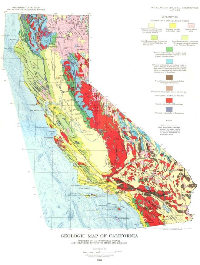
2 Strike-slip faults Horizontal motion dominantly Transforms and transfers Geomorphic evidence for sustained motion along the San Andreas Fault, including the 1857 Fort Tejon earthquake 35 mm/yr slip rate over the last 3700 yrs Wallace Creek in the Carrizo Plain, California 2
 Interseismic motion")
3 Noriega, et al Late Pleistocene-Holocene evolution of Wallace Creek (from Sieh and Jahns, 1984) Interseismic motion along the San Andreas Fault System (max arrow length=~50mm/yr relative to stable North America) 3

4 San Andreas Fault from 4


5 Transform faults Transform faults 26 October
6 6

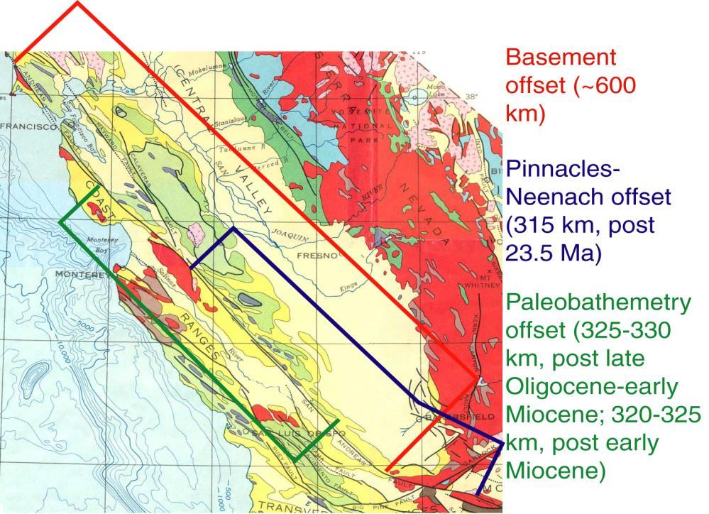
7 Areas Regions of contrasting of behavior contrasting along behavior the San Andreas in strain Fault release (from Allen, along 1968) the San Andreas Fault system (modified from Allen, 1968) Eurasian strike-slip faults and Continental escape Does continental lithosphere deform in a plate-like or more diffuse manner? 26 October Davis and Reynolds Structural Geology textbook 7


8 Geodetically measured strain accumulation in Eurasia Wang, et al., 2001 Strike-slip faults in intracontinental deformation: the Altyn Tagh left lateral strike-slip fault in Xinjiang, NW China Altyn Tagh fault system (Washburn and Arrowsmith) 8

9 Altyn Tagh fault system (Washburn and Arrowsmith) Altyn Tagh fault system (Washburn and Arrowsmith) 9


10 Altyn Tagh fault system (Washburn and Arrowsmith) Altyn Tagh fault system (Washburn and Arrowsmith) 10
 and Arrowsmith) 26")

11 Altyn Tagh fault system (Washburn and Arrowsmith) Altyn Tagh fault system (Washburn and Arrowsmith) 26 October 2004 GLG310 Structural Geology 11


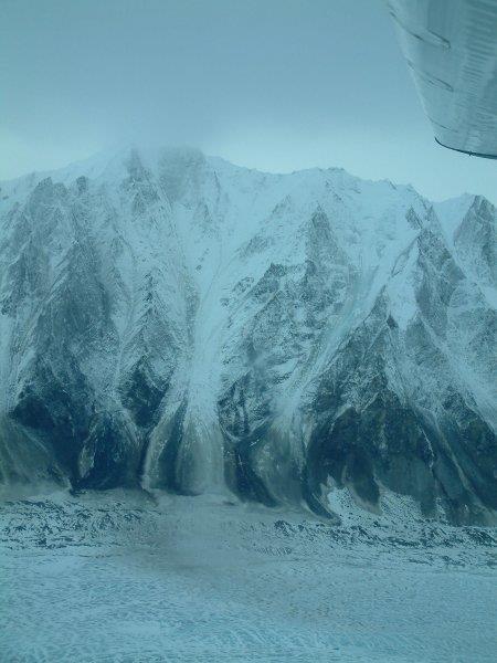
12 M7.9 Denali Earthquake Main shock and aftershocks: Tectonic setting: Denali fault accommodates right lateral motion as south Alaska moves westward north of the Aleutian subduction zone Much of what follows comes from 12

13 Rupture map Slip distribution View to the south showing the edge of a swale (arrows) offset 1.4 +/- 0.1m right-laterally and /- 0.04m up to the south, across the Denali fault during the 2002 event. The white stadia rod lies along the rupture. P. Haeussler is standing in the swale on the south side of the fault, B. Sherrod at left. Site HSS-605, km Photo by D. Schwartz. 13


14 View to the east of the Denali fault scarp on the Black Rapids Glacier. Jon Laravee, helicopter pilot, stands at the fault scarp. Avalanche debris is visible in the distance. Offset snow and ice features showed that the fault in this area produced 3.9 +/- 0.05m of right-lateral slip and /- 0.05m vertical slip, up to the north. Site PH305, km Photo by P. Haeussler. View to the east of a pull-apart in ice of the Black Rapids Glacier. The Denali fault offsets snow and ice features 3.9 +/- 0.05m right-laterally and /- 0.05m up to the north. Avalanche debris is visible in the distance. Site PH305, km Photo by P. Haeussler. 14
 and multiple minor strands (middleground), forming a rupture zone ~20m wide. Site 03-212, km 80.")

15 View north of a small, dry rill (delineated with orange flags) offset a total of m along the Denali fault. Brittle offset occurs across one major fault strand (mid-foreground, with /- 0.1m right-lateral) and multiple minor strands (middleground), forming a rupture zone ~20m wide. Site , km Photo by H. Stenner. The Denali fault on the first prominent topographic saddle west of the Delta River. Photograph was taken in November, 2002, just after the earthquake. Here, offset is 5.0 +/- 1.0m, right-lateral, and /- 0.5m, up to the north. Note the push-up in the background. There is permafrost at the bottom of the cracks. Site PH031, km Photo by P. Haeussler. 15


16 Aerial view of the Denali fault trace west of Delta River, as seen in November, Offset in this area is 5.0 +/- 1.0m, right-lateral, and /- 0.5m, up to the north. Note push-up in the central part of the photograph, where the main trace steps left. Cracks perpendicular to the fault trace in the lower left are related to slope failure during ground shaking. Site PH031, km Photo by P. Haeussler. Cantwell glacier 16


17 View south of the Denali fault trace through the north side of the Cantwell Glacier. A crevasse is offset /-0.2m right-laterally and /- 0.2m up to the south. A stadia rod and 2-m-tall P. Haeussler for scale. This site had the largest vertical slip measured in ice along the rupture. Site PH312, km Photo by P. Haeussler. The crest of a rounded slope, adjacent to a shallow erosional swale, is offset 5.1 +/- 0.1m rightlaterally, and 0.56m up to the north, along the Denali fault near Slate Creek. View is to the north. Slip occurs across a 1-m-wide rupture zone. Orange flags mark the slope crest on either side of the rupture. Site DS-21, km Photo by T. Dawson. 17


18 Aerial view north of a stream channel right-laterally offset m along the Denali fault. Site Jack Cr-1, km 182. Photo by D. Schwartz. View southeast of a right-laterally offset stream bank edge at Cooper Creek, at the southeastern extent of the Totschunda fault. Offset is /- 0.25m, right-lateral, and /- 0.1m, up to the south. Site PH101, km Photo by P. Haeussler 18


19 Mud Volcano Shaking derived phenomena Debris flow Alaska Range Slide on Glacier Alaska Range Shaking derived phenomena 19


20 Landslide across Black Rapids Glacier. The landslide moved from right to left across the valley. The ridge in the center is a medial moraine. The fault scarp is not visible in the photo. Photo by Patty Craw, DGGS. Shaking derived phenomena Clay cake experiment simulating strike-slip faulting 20
21 Structures that develop in a dextral shear zone (and then rotate with continued deformation) Strike-slip steps and bends 21
22 22
23 Description of faults Horizontal stretch Crustal thickness Regional elevation Regional character Issues Normal Thrust/reverse Strike-slip >1 <1 >1 in one direction and < 1 in another Thin Thicken No change Usually lower Usually higher No change Rifting, Mid Ocean ridges, gravitational collapse, local accommodation along strike-slip faults Detachments, Listric, rotation, rifted margins Subduction zones/accretionary prisms, continent/continent collision, back arc fold thrust belts, local accommodation along strike-slip faults Layered rocks, reverse versus thrust Transforms, oblique convergence (i.e., Sumatra), continental collision, Transfers in other fault systems Transforms, bends and stepovers 4 November 2013 GLG310 Structural Geology Description of faults Horizontal stretch Crustal thickness Regional elevation Regional character Issues Normal Thrust/reverse Strike-slip >1 <1 >1 in one direction and < 1 in another Thin Thicken No change Usually lower Usually higher No change Rifting, Mid Ocean ridges, gravitational collapse, local accommodation along strike-slip faults Detachments, Listric, rotation, rifted margins Subduction zones/accretionary prisms, continent/continent collision, back arc fold thrust belts, local accommodation along strike-slip faults Layered rocks, reverse versus thrust Transforms, oblique convergence (i.e., Sumatra), continental collision, Transfers in other fault systems Transforms, bends and stepovers 4 November 2013 GLG310 Structural Geology 23
Description of faults
 GLG310 Structural Geology Description of faults Horizontal stretch Crustal thickness Regional elevation Regional character Issues Normal Thrust/reverse Strike-slip >1 1 in one direction and < 1 in
Introduction Faults blind attitude strike dip
 Chapter 5 Faults by G.H. Girty, Department of Geological Sciences, San Diego State University Page 1 Introduction Faults are surfaces across which Earth material has lost cohesion and across which there
Chapter 4 Section 3, 4. Deforming the Earth s Crust
 Chapter 4 Section 3, 4 Deforming the Earth s Crust Deformation The process by which the shape of a rock changes because of stress Stress The amount of force per unit area on a given material Compression
Distribution of Continents Mid-ocean Ridges Trenches. Deformation Metamorphism Volcanism Earthquakes
 Earthquakes and Plate Tectonics Global Problems in Geology Distribution of Continents Mid-ocean Ridges Trenches Orogenic Belts Deformation Metamorphism Volcanism Earthquakes Development of Continental
Deformation of Rocks. Orientation of Deformed Rocks
 Deformation of Rocks Folds and faults are geologic structures caused by deformation. Structural geology is the study of the deformation of rocks and its effects. Fig. 7.1 Orientation of Deformed Rocks
1. occurs when the oceanic crust slides under the continental crust.
 1. occurs when the oceanic crust slides under the continental crust. 2. What type of stress is shown? 3. Where two plates slide past one another is called a boundary. 4. What type of stress is shown? 5.
Plate Tectonics. entirely rock both and rock
 Plate Tectonics I. Tectonics A. Tectonic Forces are forces generated from within Earth causing rock to become. B. 1. The study of the origin and arrangement of Earth surface including mountain belts, continents,
Use a highlighter to mark the most important parts, or the parts. you want to remember in the background information.
 P a g e 1 Name A Fault Model Purpose: To explore the types of faults and how they affect the geosphere Background Information: A fault is an area of stress in the earth where broken rocks slide past each
Plate Tectonics. Theory of Plate Tectonics. What is Plate Tectonics. Plate Tectonics Plate Boundaries Causes of Plate Tectonics
 Theory of Plate Tectonics Plate Tectonics Plate Boundaries Causes of Plate Tectonics Plate Tectonics What is Plate Tectonics The Earth s crust and upper mantle are broken into sections called plates Plates
Two Very Different Surface Ruptures and Some Generalizations about the Behavior of Strike-slip Faults: Denali 2002 Bulnay 1905
 Two Very Different Surface Ruptures and Some Generalizations about the Behavior of Strike-slip Faults: Denali 2002 Bulnay 1905 Tectonics of southern Alaska Horizontal slip (m) 10 8 6 4 2 West Fork Glacier
Forces That Shape Earth. How do continents move? What forces can change rocks? How does plate motion affect the rock cycle?
 Forces That Shape Earth How do continents move? What forces can change rocks? How does plate motion affect the rock cycle? Plate Motion Mountain ranges are produced by plate tectonics. The theory of plate
Crustal Deformation. Earth Systems 3209
 Crustal Deformation Earth Systems 3209 Crustal Deformation pg. 415 Refers to all changes in the original form and/or size of a rock body. May also produce changes in the location and orientation of rocks.
GEOLOGY MEDIA SUITE Chapter 13
 UNDERSTANDING EARTH, SIXTH EDITION GROTZINGER JORDAN GEOLOGY MEDIA SUITE Chapter 13 Earthquakes 2010 W.H. Freeman and Company Three different types of seismic waves are recorded by seismographs Key Figure
Finding Fault with Food or Modeling Plate Movement
 Finding Fault with Food or Modeling Plate Movement Objective: Use models to describe how tectonic plates cause major geological events such as; ocean basins, earthquakes, volcanoes, and mountain building.
Plate Boundaries & Resulting Landforms
 Plate Boundaries & Resulting Landforms Divergent Plate Boundaries (plates being pulled apart) Type: oceanic plates Description: rising magma gently lifts the crust creating a ridge. The flow of convection
Captain s Tryouts 2017
 Captain s Tryouts 2017 Dynamic Planet Test Written by: Araneesh Pratap (Chattahoochee High School) Name: Date: Answer all questions on the answer sheet. Point values are given next to each question or
Chapter 15 Structures
 Chapter 15 Structures Plummer/McGeary/Carlson (c) The McGraw-Hill Companies, Inc. TECTONIC FORCES AT WORK Stress & Strain Stress Strain Compressive stress Shortening strain Tensional stress stretching
Plate Tectonics - Demonstration
 Name: Reference: Prof. Larry Braile - Educational Resources Copyright 2000. L. Braile. Permission granted for reproduction for non-commercial uses. http://web.ics.purdue.edu/~braile/indexlinks/educ.htm
Snack Tectonics or Modeling Plate Movement
 Snack Tectonics or Modeling Plate Movement Objective: Use models to describe how tectonic plates cause major geological events such as; ocean basins, earthquakes, volcanoes, and mountain building. Questions:
Plates & Boundaries The earth's continents are constantly moving due to the motions of the tectonic plates.
 Plates & Boundaries The earth's continents are constantly moving due to the motions of the tectonic plates. As you can see, some of the plates contain continents and others are mostly under the ocean.
Answers: Internal Processes and Structures (Isostasy)
") Answers: Internal Processes and Structures (Isostasy) 1. Analyse the adjustment of the crust to changes in loads associated with volcanism, mountain building, erosion, and glaciation by using the concept
Answers: Internal Processes and Structures (Isostasy) 1. Analyse the adjustment of the crust to changes in loads associated with volcanism, mountain building, erosion, and glaciation by using the concept
Lab 1: Plate Tectonics April 2, 2009
 Name: Lab 1: Plate Tectonics April 2, 2009 Objective: Students will be introduced to the theory of plate tectonics and different styles of plate margins and interactions. Introduction The planet can be
4 Deforming the Earth s Crust
 CHAPTER 7 4 Deforming the Earth s Crust SECTION Plate Tectonics BEFORE YOU READ After you read this section, you should be able to answer these questions: What happens when rock is placed under stress?
Earth Dynamics. Landforms at Plate Boundaries
 Earth Dynamics CHAPTER 8 LESSON 2 Landforms at Boundaries What do you think? Read the two statements below and decide whether you agree or disagree with them. Place an A in the Before column if you agree
USU 1360 TECTONICS / PROCESSES
 USU 1360 TECTONICS / PROCESSES Observe the world map and each enlargement Pacific Northwest Tibet South America Japan 03.00.a1 South Atlantic Arabian Peninsula Observe features near the Pacific Northwest
What type of land feature is located at Point A? A Cliff B Delta C Mountain D Valley
 1 What type of land feature is located at Point A? A Cliff B Delta C Mountain D Valley Alfred Wegener s theory of continental drift was 2 not accepted by scientists when the theory was first proposed.
SAC Geography Form 2 Chapter 3: Plate Tectonics Topic 3: Plate Movement
 What causes an earthquake? Plate movement causes pressure to build up along faults, or breaks, in the earth's crust. When the rocks cannot take any more pressure, the rock layers shift and an earthquake
4 Deforming the Earth s Crust
 CHAPTER 7 4 Deforming the Earth s Crust SECTION Plate Tectonics BEFORE YOU READ After you read this section, you should be able to answer these questions: What happens when rock is placed under stress?
Section 2: How Mountains Form
 Section 2: How Mountains Form Preview Objectives Mountain Ranges and Systems Plate Tectonics and Mountains Types of Mountains Objectives Identify the types of plate collisions that form mountains. Identify
Notepack # 9 AIM: Why are the continents drifting apart? Do Now: Watch the video clip and write down what you observe.
 Notepack # 9 AIM: Why are the continents drifting apart? Do Now: Watch the video clip and write down what you observe. http://www.youtube.com/watch?v=ci 5P5yy0xlg&feature=related What do we know as a class,
Mountains are then built by deforming crust: Deformation & Mountain Building. Mountains form where stresses are high!
 Deformation & Mountain Building Where are mountains located? Deformation and Folding Mountain building Mountains form where stresses are high! Mountains form at all three types of plate boundaries where
Crags, Cracks, and Crumples: Crustal Deformation and Mountain Building
 Crags, Cracks, and Crumples: Crustal Deformation and Mountain Building Updated by: Rick Oches, Professor of Geology & Environmental Sciences Bentley University Waltham, Massachusetts Based on slides prepared
Full file at
 Chapter 2 PLATE TECTONICS AND PHYSICAL HAZARDS MULTIPLE-CHOICE QUESTIONS 1. What direction is the Pacific Plate currently moving, based on the chain of Hawaiian Islands with only the easternmost island
1. What is Wegener s theory of continental drift? 2. What were the 4 evidences supporting his theory? 3. Why wasn t Wegener s theory excepted?
 Notebook 7a and 7b Objective (left-side): Students will be able to explain the theory of plate tectonics and be able to make predictions about plate interactions. Mapping Reflection 1. What is Wegener
EARTHQUAKE LOCATIONS INDICATE PLATE BOUNDARIES EARTHQUAKE MECHANISMS SHOW MOTION
 6-1 6: EARTHQUAKE FOCAL MECHANISMS AND PLATE MOTIONS Hebgen Lake, Montana 1959 Ms 7.5 1 Stein & Wysession, 2003 Owens Valley, California 1872 Mw ~7.5 EARTHQUAKE LOCATIONS INDICATE PLATE BOUNDARIES EARTHQUAKE
Deformation of the Crust
 Deformation of the Crust Review Choose the best response. Write the letter of that choice in the space provided. 1. The state of balance between the thickness of the crust and the depth at which it rides
Earth Science, (Tarbuck/Lutgens) Chapter 10: Mountain Building
 Chapter 10: Mountain Building") Earth Science, (Tarbuck/Lutgens) Chapter 10: Mountain Building 1) A(n) fault has little or no vertical movements of the two blocks. A) stick slip B) oblique slip C) strike slip D) dip slip 2) In a(n) fault,
Earth Science, (Tarbuck/Lutgens) Chapter 10: Mountain Building 1) A(n) fault has little or no vertical movements of the two blocks. A) stick slip B) oblique slip C) strike slip D) dip slip 2) In a(n) fault,
Earth s Tectonic Plates
 MASTER 49 6.2 3.7 5.4 Philippine Pacific 5.4 North American Juan de Fuca Caribbean Cocos 10.0 9.2 2.3 2.5 2.3 1.8 3.0 Indian-Australian 10.5 7.1 17.2 16.8 6.0 Nazca South American 11.1 10.3 7.3 3.7 7.5
Shape Earth. Plate Boundaries. Building. Building
 Chapter Introduction Lesson 1 Lesson 2 Lesson 3 Lesson 4 Chapter Wrap-Up Forces That Shape Earth Landforms at Plate Boundaries Mountain Building Continent Building How is Earth s surface shaped by plate
Unit 4 Lesson 7 Mountain Building
 Indiana Standards 7.2.4 Explain how convection currents in the mantle cause lithospheric plates to move causing fast changes like earthquakes and volcanic eruptions, and slow changes like creation of mountains
Chapter 10: Deformation and Mountain Building. Fig. 10.1
 Chapter 10: Deformation and Mountain Building Fig. 10.1 OBJECTIVES Describe the processes of rock deformation and compare and contrast ductile and brittle behavior in rocks. Explain how strike and dip
Plates Moving Apart Types of Boundaries
 Plates Moving Apart Types of Boundaries PLATE TECTONICS IS The theory that the Earth s crust is broken into slabs of rock that move around on top of the asthenosphere. How fast are plates moving? The Arctic
Strike-Slip Faults. ! Fault motion is parallel to the strike of the fault.
 Strike-Slip Faults! Fault motion is parallel to the strike of the fault.! Usually vertical, no hanging-wall/footwall blocks.! Classified by the relative sense of motion. " Right lateral opposite block
Plate Tectonics. By Destiny, Jarrek, Kaidence, and Autumn
 Plate Tectonics By Destiny, Jarrek, Kaidence, and Autumn .The Denali Fault and San Andreas Fault - The San Andreas Fault is a continental transform fault that extends roughly 1300 km (810 miles) through
The Two Types of Crust. Plate Tectonics. Physical Layers of the Earth. The Asthenosphere. The Lithosphere. Chemical Layers of the Earth
 Plate Tectonics A Reminder of Earth s Structure Two physical units of Earth that are important too! How the Earth Works Plate Tectonics Plate Boundaries Chemical Layers of the Earth Crust - low density
Learning goals - January 16, Describe the geometry of a fault (1) orientation of the plane (strike and dip) (2) slip vector
 orientation of the plane (strike and dip) (2) slip vector") Learning goals - January 16, 2012 You will understand how to: Describe the geometry of a fault (1) orientation of the plane (strike and dip) (2) slip vector Understand concept of slip rate and how it is
Learning goals - January 16, 2012 You will understand how to: Describe the geometry of a fault (1) orientation of the plane (strike and dip) (2) slip vector Understand concept of slip rate and how it is
Plate Tectonics Notes
 Plate Tectonics Notes Last 30 Days Earthquakes Physical Features Last 30 Days Earthquakes with Plate Boundaries Earth s Structure Earth s Layers Core: Inner Core: Center of the earth, solid ball of metal
Mohorovicic discontinuity separates the crust and the upper mantle.
 Structure of the Earth Chapter 7 The Earth is divided into 3 Main Layers 1. Crust outermost layer 1% of the Earth s mass thickness varies: 5 100 km two types: oceanic denser continental Mohorovicic discontinuity
Crustal Boundaries. As they move across the asthenosphere and form plate boundaries they interact in various ways. Convergent Transform Divergent
 Name: Date: Period: Plate Tectonics The Physical Setting: Earth Science CLASS NOTES Tectonic plates are constantly moving and interacting As they move across the asthenosphere and form plate boundaries
3. PLATE TECTONICS LAST NAME (ALL IN CAPS): FIRST NAME: PLATES
: FIRST NAME: PLATES") LAST NAME (ALL IN CAPS): FIRST NAME: PLATES 3. PLATE TECTONICS The outer layers of the Earth are divided into the lithosphere and asthenosphere. The division is based on differences in mechanical properties
LAST NAME (ALL IN CAPS): FIRST NAME: PLATES 3. PLATE TECTONICS The outer layers of the Earth are divided into the lithosphere and asthenosphere. The division is based on differences in mechanical properties
Geologic Structures. Changes in the shape and/or orientation of rocks in response to applied stress
 Geologic Structures Changes in the shape and/or orientation of rocks in response to applied stress Figure 15.19 Can be as big as a breadbox Or much bigger than a breadbox Three basic types Fractures >>>
Chapt pt 15 er EARTHQUAKES! BFRB P 215 ages -226
 Chapter 15 EARTHQUAKES! BFRB Pages 215-226226 Earthquake causes An earthquake is the shaking of the Earth s crust caused by a release of energy The movement of the Earth s plates causes most earthquakes
Plate Tectonics. Structure of the Earth
 Plate Tectonics Structure of the Earth The Earth can be considered as being made up of a series of concentric spheres, each made up of materials that differ in terms of composition and mechanical properties.
The Theory of Plate Tectonics - Boundaries, Stresses, and Faults
 The Theory of Plate Tectonics - Boundaries, Stresses, and Faults 1. What is the theory of plate tectonics? 2. What are the three types of plate boundaries? What are Plates? The Earth s crust and upper
Tectonic geomorphology
 Tectonic geomorphology studies processes and landforms controlled by tectonics Change in landscape caused by change in landscape process Look for morphological anomalies surfaces warped, tilted, uplifted,
Directed Reading. Section: How Mountains Form MOUNTAIN RANGES AND SYSTEMS. Skills Worksheet
 Skills Worksheet Directed Reading Section: How Mountains Form 1. How high is Mount Everest? a. about 1980 km above sea level b. more than 8 km below sea level c. more than 8 km above sea level d. more
From Earthquakes to Mountains: the Earth s Crust in Motion
 Dean s Freshman Honor Seminar (SCI 110) Eric Calais Associate Professor of Geophysics Purdue University Department of Earth and Atmospheric Sciences ecalais@purdue.edu http:/www.eas.purdue.edu/~calais
deep within the planet. They are also shaped by conditions on the planet s surface. In
 Chapter 4 Landforms, Water, and Natural Resources Earth is home to many different types of landforms. These landforms are shaped by forces deep within the planet. They are also shaped by conditions on
Earthquakes & Volcanoes
 Earthquakes & Volcanoes Geology - the study of solid Earth, the rocks of which it is composed, and the processes by which they change geo = Earth; ology = study of Earth s Layers Plate Tectonics - the
Neotectonic Implications between Kaotai and Peinanshan
 Neotectonic Implications between Kaotai and Peinanshan Abstract Longitudinal Valley was the suture zone between the Philippine Sea plate and the Eurasia plate. Peinanshan was the southest segment of the
Boundaries, Stresses, and Faults OH MY! How do geologic events change and shape Earth s surface?
 Boundaries, Stresses, and Faults OH MY! How do geologic events change and shape Earth s surface? Remember The Lithosphere is made of The CRUST + The Upper Rigid Mantle Plates may be called by different
What Are Tectonic Plates?
 Plate Tectonics The theory that the Earth s outermost layer is fragmented into a dozen or more large and small plates that move relative to one another as they ride on top of hotter, more mobile material.
The Basics The lithosphere is made up of numerous plates (14 major, 38 minor)
") The Basics The lithosphere is made up of numerous plates (14 major, 38 minor) These plates float atop the asthenosphere, where they can move (albeit very slowly) Plate tectonics describes the formation,
The Basics The lithosphere is made up of numerous plates (14 major, 38 minor) These plates float atop the asthenosphere, where they can move (albeit very slowly) Plate tectonics describes the formation,
Convergent plate boundary.
 Crustal Deformation Convergent plate boundary http://my.execpc.com/~acmelasr/mountains/geogramsnf.html Plate Tectonic Settings and Magma Where plates CONVERGE, water is driven off the subducting plate,
A physical feature of the Earth s surface
 Earth s Landforms A physical feature of the Earth s surface A physical feature of the Earth s surface LANDFORM Highest of Earth s physical features Highest of Earth s physical features MOUNTAIN Low area
Mountains and Mountain Building: Chapter 11
 Mountains and Mountain Building: Chapter 11 Objectives: 1)Explain how some of Earth s major mountain belts formed 2) Compare and contrast active and passive continental margins 3) Explain how compression,
Geology 300, Physical Geology Spring 2019 Quiz Ch 19, Plate Tectonics Name
 Geology 300, Physical Geology Spring 2019 Quiz Ch 19, Plate Tectonics Name MULTIPLE CHOICE. Choose the one alternative that best completes the statement or answers the question. 1) The portion of a fracture
Crustal Activity. Plate Tectonics - Plates - Lithosphere - Asthenosphere - Earth s surface consists of a major plates and some minor ones
 Name: Date: Period: Tectonics The Physical Setting: Earth Science CLASS NOTES Tectonics - s - Lithosphere - Asthenosphere - Earth s surface consists of a major plates and some minor ones The plates are
Beneath our Feet: The 4 Layers of the Earty by Kelly Hashway
 Beneath our Feet: The 4 Layers of the Earty by Kelly Hashway The Earth is more than a giant ball made up of dirt, rocks, and minerals. The Earth may look like a giant ball from when looking at it from
Geology of the Pacific Northwest
 Geology of the Pacific Northwest Pat Pringle photo, April 16, 1983 Group sedimentary northeast of Ashford of Eocene age
December 21, Chapter 11 mountain building E.notebook. Feb 19 8:19 AM. Feb 19 9:28 AM
 Mountains form along convergent plate boundaries. Typically (usually) if you look at a mountain range, you know that it is at a plate boundary (active continental margin) or has been some time in the past
Refer to the map on page 173 to answer the following questions.
 Chapter 8-1 Plate Tectonics 1. Brainstorm the type of evidence that would indicate a climate change and how this evidence supports the theory of continental drift. Tropical fossils in cold regions Evidence
Earthquakes and Seismotectonics Chapter 5
 Earthquakes and Seismotectonics Chapter 5 What Creates Earthquakes? The term Earthquake is ambiguous: Applies to general shaking of the ground and to the source of the shaking We will talk about both,
Plate Tectonics Unit II: Plate Boundaries (3.5 pts)
") T. James Noyes, El Camino College Plate Tectonics Unit II: The Plate Boundaries (Topic 11A-2) page 1 Name: Section: Plate Tectonics Unit II: Plate Boundaries (3.5 pts) Plate Boundaries We will now discuss
T. James Noyes, El Camino College Plate Tectonics Unit II: The Plate Boundaries (Topic 11A-2) page 1 Name: Section: Plate Tectonics Unit II: Plate Boundaries (3.5 pts) Plate Boundaries We will now discuss
FORCES ON EARTH. An investigation into how Newton s Laws of Motion are applied to the tectonic activity on Earth.
 FORCES ON EARTH An investigation into how Newton s Laws of Motion are applied to the tectonic activity on Earth. GEOLOGY Geologists scientists who study the forces that make and shape the Earth Geologists
Learning Objectives (LO)! Lecture 11: Plate Tectonics II! No Homework!! ** Chapter 3 **! What we ll learn today:!
! Lecture 11: Plate Tectonics II! No Homework!! ** Chapter 3 **! What we ll learn today:!") Learning Objectives (LO)! Lecture 11: Plate Tectonics II! No Homework!! ** Chapter 3 **! What we ll learn today:! 1. List the three types of tectonic plate boundaries! 2. Describe the processes occurring
Learning Objectives (LO)! Lecture 11: Plate Tectonics II! No Homework!! ** Chapter 3 **! What we ll learn today:! 1. List the three types of tectonic plate boundaries! 2. Describe the processes occurring
Staple this part to part one of lab 6 and turn in. Lab 6, part two: Structural geology (analysis)
") Geology 101 Staple this part to part one of lab 6 and turn in Lab 6, part two: Structural geology (analysis) Recall that the objective of this lab is to describe the geologic structures of Cougar Mountain
Geology 101 Staple this part to part one of lab 6 and turn in Lab 6, part two: Structural geology (analysis) Recall that the objective of this lab is to describe the geologic structures of Cougar Mountain
Earth s Dynamic Surface
 Earth s Dynamic Surface Shaping Earth s Surface What do you think? Read the two statements below and decide whether you agree or disagree with them. Place an A in the Before column if you agree with the
8 th Grade Science Plate Tectonics and Topography Review
 8 th Grade Science Plate Tectonics and Topography Review #1 Scientists believe that the land masses of Earth were once joined together as one supercontinent called. A: Australia B: Wegner C: Pangaea D:
6. In the diagram below, letters A and B represent locations near the edge of a continent.
 1. Base your answer to the following question on the cross section below and on your knowledge of Earth science. The cross section represents the distance and age of ocean-floor bedrock found on both sides
FINAL EXAM Crustal Deformation CONVERGE DIVERGENT PLATES MANTLE PLUMES FLUX BASALTIC GRANITIC
 Crustal Deformation Reading: Chapter 10 Pages 283-304 Review Questions 4, 6, 7, 10, 12, 15, 18, 20 FINAL EXAM NOON TO 2 PM, TUESDAY DEC. 5 HERE: Natural Science 101 BRING A SCAN TRON TURN IN YOUR REVIEW
22.5 Earthquakes. The tsunami triggered by the 2004 Sumatra earthquake caused extensive damage to coastal areas in Southeast Asia.
 The tsunami triggered by the 2004 Sumatra earthquake caused extensive damage to coastal areas in Southeast Asia. An earthquake is a movement of Earth s lithosphere that occurs when rocks in the lithosphere
FINAL EXAM Crustal Deformation CONVERGE DIVERGENT PLATES MANTLE PLUMES FLUX BASALTIC GRANITIC
 Crustal Deformation Reading: Chapter 10 Pages 283-294 FINAL EXAM 8 to 10 AM, THURSDAY DEC. 6 HERE: Natural Science 101 BRING A SCAN TRON TURN IN YOUR REVIEW QUESTIONS BEFORE THE TEST, PICK UP WHEN YOU
What Causes Rock to Deform?
 Crustal Deformation Earth, Chapter 10 Chapter 10 Crustal Deformation What Causes Rock to Deform? Deformation is a general term that refers to all changes in the shape or position of a rock body in response
Continental Drift Discussion Questions:
 Continental Drift Discussion Questions: 1) What are tectonic plates? 2) What happens at the boundaries between these plates? 3) What are fault lines? 4) What effect has Continental Drift had on the shape
GEOL104: Exploring the Planets LAB 5: PLANETARY TECTONICS
 GEOL104: Exploring the Planets LAB 5: PLANETARY TECTONICS OBJECTIVES: I. Understand the three basic types of tectonic interactions that can occur II. Identify tectonic interactions on other planets MATERIALS:
Lecture # 6. Geological Structures
 1 Lecture # 6 Geological Structures ( Folds, Faults and Joints) Instructor: Dr. Attaullah Shah Department of Civil Engineering Swedish College of Engineering and Technology-Wah Cantt. 2 The wavy undulations
Chapter 7 Plate Tectonics. Plate tectonics accounts for important features of Earth s surface and major geologic events.
 Chapter 7 Plate Tectonics Plate tectonics accounts for important features of Earth s surface and major geologic events. 7-2 Alfred Wegener s Hypothesis of Continental Drift (1915) He noticed that the continents
Geology Topics. Unit 6 Notes
 Geology Topics Unit 6 Notes Composition of the Earth Earth is layered due to density differences. Crust thin outer layer, solid, made up of continental and oceanic crust Mantle rocky layer below the crust
Earthquakes and Earthquake Hazards Earth - Chapter 11 Stan Hatfield Southwestern Illinois College
 Earthquakes and Earthquake Hazards Earth - Chapter 11 Stan Hatfield Southwestern Illinois College What Is an Earthquake? An earthquake is the vibration of Earth, produced by the rapid release of energy.
INTRODUCTION TO EARTHQUAKES
 INTRODUCTION TO EARTHQUAKES Seismology = Study of earthquakes Seismologists = Scientists who study earthquakes Earthquake = Trembling or shaking of the earth s surface, usually as a result of the movement
10. Paleomagnetism and Polar Wandering Curves.
 Map of ocean floor Evidence in Support of the Theory of Plate Tectonics 10. Paleomagnetism and Polar Wandering Curves. The Earth's magnetic field behaves as if there were a bar magnet in the center of
UNIT 6 PLATE TECTONICS
 UNIT 6 PLATE TECTONICS CONTINENTAL DRIFT Alfred Wegner proposed the theory that the crustal plates are moving over the mantle. He argued that today s continents once formed a single landmass, called Pangaea
depression above scarp scarp
 1 LAB 1: FIELD TRIP TO McKINLEYVILLE AND MOUTH OF THE MAD RIVER OBJECTIVES: a. to look at geomorphic and geologic evidence for large scale thrust-faulting of young sediments in the Humboldt Bay region
PHYSICAL GEOLOGY AND THE ENVIRONMENT (2 ND CANADIAN EDITION)
") Chapter 2: Plate Tectonics Chapter Summary: Plate tectonics is a theory that suggests Earth's surface is divided into several large plates that change position and size. Intense geologic activity occurs
Chapter 2: Plate Tectonics Chapter Summary: Plate tectonics is a theory that suggests Earth's surface is divided into several large plates that change position and size. Intense geologic activity occurs
12. The diagram below shows the collision of an oceanic plate and a continental plate.
 Review 1. Base your answer to the following question on the cross section below, which shows the boundary between two lithospheric plates. Point X is a location in the continental lithosphere. The depth
Chapter 16. Mountain Building. Mountain Building. Mountains and Plate Tectonics. what s the connection?
 Chapter 16 Mountains and Plate Tectonics what s the connection? Mountain Building Most crustal deformation occurs along plate margins. S.2 Active Margin Passive Margin Mountain Building Factors Affecting
Crustal Deformation Earth - Chapter Pearson Education, Inc.
 Crustal Deformation Earth - Chapter 10 Structural Geology Structural geologists study the architecture and processes responsible for deformation of Earth s crust. A working knowledge of rock structures
UNIT 11 PLATE TECTONICS
 UNIT 11 PLATE TECTONICS A. ALFRED WEGENER 1. Continental drift hypothesis Single supercontinent called Pangaea 200 million years ago Pangaea (all land) began to break up and started drifting to their present
Unit 11: Plate Tectonics
 Unit 11: Plate Tectonics A. Alfred Wegner 1. Continental drift hypothesis a. single supercontinent called Pangaea b. 200 million years ago Pangaea (all land) began to break up and started drifting to their