Interisland Cable Ocean Floor Survey. Final Report
|
|
|
- Marsha Ward
- 5 years ago
- Views:
Transcription


1 Interisland Cable Ocean Floor Survey Final Report
2 Contents 1. Executive Summary Background Task Compilation of Existing Data Gap Analysis Cable Landing Sites Technical Cable Requirements Initial Cable Route Suggestions Task New Data Collection Recommended submarine cable routes and alternatives Routes to Pearl-Honolulu Harbor Pearl Harbor/Honolulu Harbor to Lāna i Kāne ohe to NW Moloka i NW Molokai to Lanai O ahu to Moloka i /Lāna i to Maui Alternative Routes Routes not recommended Existing seafloor cables Cable burial Benthic macro fauna Summary i
3 1. Executive Summary This report contains the results of the ocean floor survey conducted between the Hawaiian Islands of O ahu, Lāna i, Moloka i and Maui. The purpose of this survey was to determine the feasibility of physically laying a power transmission cable on the sea floor between these islands for the purpose of transmitting renewable energy generated on Lāna i and Moloka i to O ahu and possibly Maui. The results of the survey show that laying a power transmission cable between the islands is physically possible via a number of different routes. Each route presents its own engineering and environmental challenges. Recommended (black) and alternate (dashed) cable routes, other routes surveyed (white dashed), on sunlit bathymetry (gray)and seafloor acoustic imagery (red = strong, green = weak). Pink = existing cable; Red dot = observed cable crossing Blue box = bottom fish refuge; Red box/circle = dump areas Ruled area = humpback whale sanctuary Certain questions, however, remain unanswered, including: How to precisely lay the cables around deep-water obstacles, such as former reefs, dumped materials and munitions; How to connect the cables to shore under (via micro-tunnels) and/or over (via dredged micro-channels) fringing coral reefs that are up to 2 km across; and, Whether and/or how to bury the cables in areas of hard substrate. These questions will be resolved when the cable developer is hired. The environmental impacts of the project will be addressed in the environmental impact statement ( EIS ) for the proposed interisland cable. The Department of Business, Economic Development, and Tourism would like to thank the University of Hawaii at Mānoa School of Ocean and Earth Science and Technology for their research hard work on this project. 2
4 2. Background On October 20, 2008 the State of Hawai i ( State ) entered into an Energy Agreement between it and Hawaiian Electric which was signed by the Governor of the State of Hawai i, the Department of Business Economic Development and Tourism (DBEDT), the Consumer Advocate, and Hawaiian Electric, on behalf of itself and its subsidiaries, Hawaii Electric Light Company, Inc. and Maui Electric Company, Limited (collectively, the HCEI Parties ). The Energy Agreement commits the HCEI Parties to pursue a wide range of actions with the purpose of decreasing the State s dependence on imported fossil fuels through substantial increases in the use of renewable energy and implementation of new programs intended to secure greater energy efficiency and conservation. In the Energy Agreement, Hawaiian Electric has committed to integrate and, with the assistance of the State, to accelerate the commitment for up to 400 megawatts ( MW ) of wind energy into the O ahu electrical system (the Interisland Wind Initiative ). The wind energy is expected to be produced by one or more wind facilities located on the islands of Lāna i and/or Moloka i and transmitted to O ahu and potentially Maui via an undersea cable (the Interisland Cable ). With respect to the Interisland Cable, the State agreed to coordinate with developers, contractors, and/or Hawaiian Electric as the circumstances merit, on all matters related to the development of the Interisland Cable. The State delegated the responsibility of the Interisland Cable development to DBEDT. As lead agency for this effort, DBEDT s tasks include, but are not limited to, conducting or having contractors and/or consultants conduct the appropriate engineering and design of the Interisland Cable, assist with the acquisition and approvals of all necessary offshore and on-shore land rights permits and approvals including the EIS. The Interisland Cable, as envisioned, consists of an undersea transmission cable system with a minimum transfer capability of four-hundred (400) megawatts ( MW ) to integrate either 1) the proposed two-hundred (200) megawatt wind facility on Lāna i and the two-hundred (200) megawatt wind facility on Moloka i with O ahu s electric grid; or, (2) possibly a single wind facility located on either Lāna i or Moloka i with O ahu s electric grid. A later phased cable extension to Maui is also proposed. As part of this work effort, the State will draft a programmatic EIS for the Interisland Wind Initiative, with input from the wind developers on Lāna i and Moloka i and from HECO and MECO on O ahu and Maui. The wind developers are responsible for drafting their own respective Environmental Assessments and/or EISs for their individual wind farms. HECO and MECO are responsible for drafting their own respective EAs and/or EISs for the utility infrastructure upgrades on O ahu and Maui. The State is responsible for drafting the required environmental review documentation for the Interisland Cable. Before proceeding with the considerable cost and work effort associated with the EIS for the Interisland Cable, DBEDT needed to first determine if laying a power transmission cable on the ocean floor between the islands O ahu, Lāna i, Moloka i and Maui was feasible from a physically standpoint. DBEDT contracted with the University of Hawaii at Mānoa, School of Ocean and Earth Science and Technology (UHM-SOEST) to compile all existing ocean floor 3
 discrete tasks with subtasks and sequential program review.")
5 data, to survey the gaps in the ocean floor data, and to recommend cable routes based on the survey results to facilitate this investigation. The project was broken into two (2) discrete tasks with subtasks and sequential program review. Task 1: Compile existing data regarding bathymetry, critical habitats, and seafloor; and, Task 2: Collect and process bathymetric and seafloor data The results of both tasks are described below. 3. Task 1 For Task 1, DBEDT asked UHM-SOEST to perform a desktop study to compile/process relevant existing ocean floor data, determine critical gaps in existing information, and recommend a program of new data collection and interface with DBEDT and its consultants, contractors and advisors on engineering and design parameters of the proposed cables and routes Compilation of Existing Data As part of Task 1, UHM-SOEST made a digital compilation of publicly available bathymetry data gridded at 10 meters, for the seafloor area between O ahu, Moloka i, Lāna i and Maui. Figure 1 below in an example of the bathymetric data available as of April 30, Figure 1 Bathymetric data as of April 30, 2009 UHM-SOEST consulted with the State Office of Planning, which has an extensive GIS database, including marine layers ( COASTAL/MARINELAYERS) that include the location of existing public submarine cables ( the Hawaiian Islands Humpback Whale National Marine Sanctuary ( and other restricted/managed areas. 4
. The benthic region begins at the shore line (intertidal or eulittoral zone) and extends downward out to sea. See NOAA National Centers for Coastal Ocean Science (NCCOS). 2007.")

6 UHM-SOEST reviewed and collected data from the National Oceanic and Atmospheric Administration (NOAA) commissioned study which describes the near-shore benthic habitats in the main Hawaiian Islands. (See Figure 2). The benthic region begins at the shore line (intertidal or eulittoral zone) and extends downward out to sea. See NOAA National Centers for Coastal Ocean Science (NCCOS) Atlas of the Shallow-Water Benthic Habitats of the Main Hawaiian Islands. NOAA Technical Memoradum NOS NCCOS 61, Biogeography Team. Silver Springs, MD. 331 pp. Figure 2- Near shore benthic habitat off of Kāne ohe UHM-SOEST reviewed and collected data from the United States Geologic Service studies of the benthic habitats offshore the south coast of Moloka i. (See Figure 3 and i.html). Figure 3 - Near Shore benthic habitat near south Moloka'i UHM-SOEST also reviewed and collected data from 30 KHz sidescan sonar coverage offshore SE O ahu and north of Maui. (See Figure 4). Figure 4-30 KHz sidescan sonar coverage offshore SE O ahu 5
7 3.2. Gap Analysis Once the data collection was complete, UHM-SOEST determined it had bathymetry data covering ~95% of the study region (see Figure 1). Of the ~5% data gaps remaining, certain critical points including the shallow water areas east of Kailua-Makapuu, around Ilio Point NW Moloka i, south of central Moloka i, north of Lāna i, and north of Kahalui Maui that needed to be surveyed in order to better define the recommended and alternate undersea cable routes between O ahu, Lāna i, Moloka i and Maui Cable Landing Sites Cable routes are uniquely prescribed by their end points. The final landing sites for the cable will be selected after the environmental review for the Interisland Wind and Interisland Cable project are complete. Sites needed to be identified however, in order to conduct the ocean floor survey. DBEDT asked UHM-SOEST to consider landings at Pearl-Honolulu Harbor and Kāne ohe (to connect to the Iwilei and Ko olau sub-stations) on O ahu, NW Moloka i and north Lāna i (to connect to proposed wind farms), and south Moloka i (as part of a possible land-sea route between NW Moloka i and Lāna i). Where underwater cables would best link to the Maui electric grid has not been determined. Therefore the candidate sites on NW Maui and near Kahalui are provisional Technical Cable Requirements Following the collection of data, UHM-SOEST met with DBEDT and its consultants to determine the following key parameters for the proposed undersea power cables: High voltage, direct current cables are recommended for the size (~400 MW) and length of submarine cables (>20 miles) envisioned. Existing (double armored) cable technology and laying techniques (direct lay or buried) can be utilized at ocean depths to 800 m. For cable protection, burial 1-2 m sub-bottom is desirable in water 100 m or shallower, and may be considered for all water depths. Cables should be routed to avoid steep slopes, sharp changes in slopes, suspended spans, or bending radii less than 6 m. Cables can be lain on slopes up to 30 degrees, and up to 45 degrees with cable anchoring. Directionally drilled micro-tunnels used in shore areas to minimize impacts can be up to 1.5 km long Initial Cable Route Suggestions Based on the desk-top study and gap analysis, the technical cable requirements, available information on proposed sites for cable landings and converter stations, and it s knowledge of marine geology, benthic biology and oceanography, UHM-SOEST developed a set of initial submarine cable routes and alternatives. Principles that guided UHM-SOEST s recommended routes included: minimize distance (given cost of cable); keep depth above 800 m (for better navigation and less weight of cable during laying); minimize length in whale sanctuary and other marine protected/restricted areas; 6

8 minimize crossing of steep slopes, hard grounds, important benthic habitats, precious corals and dumped materials; minimize crossing existing telecom cables; and, prefer crossings at high angles. From existing data UHM-SOEST recognized numerous constraints, including: no viable route north of Moloka i given the submarine canyons and landslides; connecting Moloka i, Lāna i, and Maui will require cables in the whale sanctuary; offshore areas less than 120-m-deep were sub-aerially exposed and eroded during the last glacial maximum 20,000 years ago; during subsequent sea level rise, modern coral reefs grew and now fringe all the islands; living (including precious) corals and extremely rugged seafloor dominate between east Lāna i and west Maui Kihei; generally steep edges of Penguin Bank and O ahu approaches; no viable route across SE Penguin Bank (rugged and steep paleo-reef slopes); deep former reefs occur in some places between the islands; and, material dumped south of Pearl and Honolulu Harbors. Using these criteria and the data collected previously, UHM-SOEST developed nine (9) possible routes shown in Figure 5. Figure 5 - Initial Cable Route Suggestions 7
9 4. Task 2 For Task 2, DBEDT asked UHM-SOEST to collect and process and analyze uncharted bathymetric data, sidescan, seafloor sampling and video of the targeted seafloor along the possible routes identified in Task 1. (See Figure 5). For this task DBEDT also asked UHM- SOEST to recommend routes for the Interisland Cable between O ahu, Lāna i, Moloka i and Maui based solely on the information gathered. The route recommendations were to be based on analyses of seafloor characteristics, bathymetry data, video and interface with DBEDT and its consultants, contractors and advisors on engineering and design parameters of the proposed cables and routes. Task 2 was broken down into the following sub-tasks: Task 2a: Collect and process new bathymetric data of nearshore Lāna i and south of Moloka i. Task 2a: Determine the initial recommended and alternative routing corridor for the undersea cable between O ahu, Moloka i, Lāna i and Maui based on the new and existing bathymetric data, along with landing sites on O ahu, Moloka i, Lāna i, and Maui. Task 2b: Based on the recommended and alternative routes for the cable perform a combination of sidescan/subbottom profiling along the seafloor between the islands. Task 2b: Based on the sidescan/subbottom profiles, determine what changes need to be made to the recommended and alternative routing corridor for the undersea cable between the islands. Task 2c: Based on the amended recommended and alternative routing corridors of the undersea cable, perform camera/video surveys of the seafloor and seafloor sampling along various points along the route. Task 2d: Prepare a Task 2 technical final report detailing the steps taken to determine the recommended and alternative routes for the undersea cable and provide GIS maps of the final recommended routes and alternatives New Data Collection To develop the initially proposed routes and alternatives, UHM-SOEST collected new data that included (1) shallow water multibeam bathymetry mapping (using the 25 NOAA survey launch R/V Ahi) to fill the existing shallow water (<200 m depth) data gaps around where the cables may be routed, and (2) cruises of R/V Ka imikai-o-kanaloa (see Figure 6) that surveyed along the proposed cable routes using deep-towed sub-bottom profiling and sidescan, camera/video transects, and seafloor sampling at various points. (See Figure 7). 8

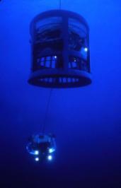
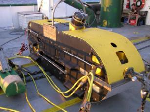
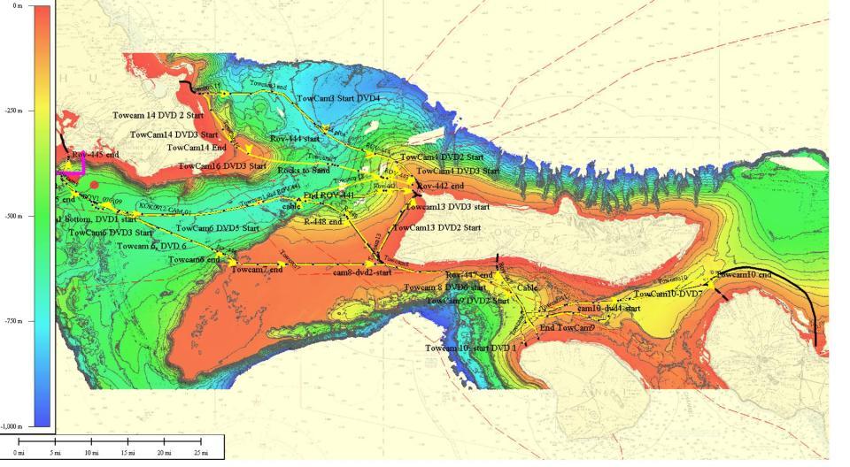
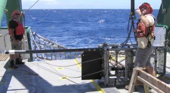
10 Figure 6 R/VAhi and Ka'imikai-O-Kanaloa, ROV video camera, Deep tow Sonar, and Tow Cam and Magnetometer Figure 7 Camera/Video Surveys 9


11 Additional swath bathymetry data from an independent twoday R/V Kilo Moana (Figure 8) cruise in July was also added to fill deeper water data gaps, resulting in a nearly complete grid of swath bathymetry, and one that fully covers all the considered cable routes. Figure 8 R/V Kilo Moana Detailed near-shore surveys to better characterize the shallow-water substrate will be performed when the exact landing sites are determined Recommended submarine cable routes and alternatives Following analysis of the new and existing information, UHM-SOEST recommended and identified alternate undersea cable routes between O ahu, Moloka i, Lāna i and Maui, based on the discussion and data interpretation that follows. An integrated ARC-GIS project volume of the seafloor data, together with the recommended routes, accompanies this report (the sub-bottom profiles, core descriptions, magnetometer and CTD profiles are in separate files, previously supplied). Priority was given to determining viable routes where the cable may be laid. The areas where the cable may be buried or covered, and at what cost, remains to be determined. The issue of burying the cable will be looked at in greater detail in the forth coming environmental review for the interisland cable project Routes to Pearl-Honolulu Harbor For the proposed interisland power cable to reach the Iwilei substation in Honolulu they have to cross the wide coral reef along the south O ahu shore. Five reef crossings have been dredged previously (Figure 9), the three deepest being the entrances to Pearl Harbor, Ke ehi Lagoon and Honolulu Harbor, the two others being at either end of the Honolulu airport runway. Figure 9 Honolulu and Pearl Harbors 10

12 Dredged materials from these and other excavations (e.g. Ala Wai canal), plus several man-made materials and munitions, have been dumped over the years to the south of Oahu. See Figure 10. Figure 10 Dump material south of Honolulu Harbor UHM-SOEST recommends the undersea cables should avoid, to the extent possible, this region of dumped materials by routing the cables to the east or to the west of the large concentration of debris that occurs south of Honolulu airport. Either choice does not obviate the need for careful placement to avoid less concentrated debris and munitions scattered further away. UHM-SOEST recommends the western route to avoid high concentrations of debris immediately south of the Honolulu Harbor entrance, to keep the submarine cable away from the high-use areas offshore Waikiki-Kaka ako, and to not impede plans for future seawater A/C (and other) pipes off Honolulu-Waikiki. A cable laid to the entrance of the Pearl Harbor dredged channel could be routed ashore to the converter station, and another cable from there to the Iwilei substation, in several ways in part depending on the desired location and permitting of the converter station. This route could involve a combination of underwater segments (e.g., the various dredged channels, the submarine terrace south of the reef runway, through Ke ehi lagoon, and under Sand Island Bridge to west Honolulu Harbor) and/or subaerial segments (e.g., edge of reef runway, Pearl Harbor military base, H1 right-of-way). The identification of these terrestrial and amphibious alternatives is beyond the scope of DBEDT/UHM-SOEST contract. 11
13 4.4. Pearl Harbor/Honolulu Harbor to Lāna i The UHM-SOEST recommended cable route between Pearl and Honolulu Harbor and Lāna i trends SSW from the entrance of the Pearl Harbor dredged channel down the slope, with minor course changes to avoid obstacles identified in the sidescan sonar and bathymetry. (See Figure 11). The sub-bottom profile shows no significant sonar penetration, indicating a compact/hard substrate. At the base of slope (~400 meters water depth) the route curves to the southeast (to avoid the paleo-reef further south and west) and then east. Figure 11 - Pearl-Honolulu to Lanai The route stays south of the main dumping fields and just north of a telecom cable (that may have become buried, UHM-SOEST did not see it in sidescan or video). Here the profile shows significant sub-bottom reflections and gravity coring penetrated ~1m of sandy mud, indicating 12

14 good potential to bury a cable. This route weaves between a myriad of dumped materials and munitions that litter the seafloor until passing east of Diamond Head. O ahu and Moloka i were once connected by surrounding coral reefs in much the same way as Lāna i and west Maui are today. That former reef edge is now at depths of m in the Ka iwi Channel. The recommended cable route continues east with good sub-bottom reflectors until crossing the former reef edge. Thereafter sub-bottom reflectors are observed only intermittently and the substrate is often compact/hard. The recommended route avoids outcrops and scours seen in the sidescan and rises up onto Penguin Bank at a place where the slope is less steep than further west, and via a sloped channel that is more easterly of the route originally considered. On top of Penguin Bank, to the west and south of Moloka i, the substrate is compact/hard. Gravity core catchers returned carbonate sand and gravel, but there was no significant core penetration. There is a sand dune field off the SW corner of Moloka i. (See Figure 12). Figure 12 Sand Dunes off the SW Corner of Moloka i The route continues east, staying south of the Moloka i s fringing coral reef and north of an existing telecom cable, submarine canyon head and paleo-reef complex. The narrow corridor between these bounding features is a critical path and choke point for all the recommended cable routes connecting O ahu, Moloka i and Lāna i. Curving to the SE and then south, the route crosses a terrace at ~300 m depth with good sub-bottom reflectors (although poor core recovery 13
15 of sandy mud) before climbing the slope up to NW Lāna i where there are sandy beaches and a narrow fringing reef Kāne ohe to NW Moloka i The recommended cable route from Kāne ohe to NW Moloka i lands at Kāne ohe Marine Air Station on O ahu where a cable could be run along the H3 right-of-way to the Ko olau substation. (See Figure 13). Near shore to the east there is a 2 kilometer wide reef terrace. Along part of this route the substrate remains thinly sedimented over reef rock until passing around the submarine canyon head east of Kailua and down off the shelf. Coring the slope recovered 1 meter of silty mud. Figure 13 - Kāne ohe to NW Moloka i 14
.")
16 The easterly route crosses low-relief channels coming off Waimanalo and stays north of the bottom fish refuge until turning around it (and associated deep former reef) to the SE. The m deep flat area has good sub-bottom reflectors (though core recovery of the carbonate mud-silt-sand was spotty). These reflectors end when the route crosses onto a deep former reef to the SE. The route weaves around rock outcrops seen in the sidescan and up the slope to NW Moloka i. Sidescan indicates that the shelf north of north west Moloka i is hard reef substrate, with rugged karst in places. To avoid the worst of this, the route comes in from the WNW towards Ilio Point, crosses a low point in the relict reef edge, then trends SE to where the modern reef is narrowest (allowing the cable to pass underneath in a micro-tunnel). At the coastal end of a dirt road there is a sandy landing site. A cable right-of-way could pass along the dirt road to the proposed wind farm further east. (See Figure 14). Figure 14 - Ilio Point on NW Molokai 15
 sediments identified on the sidescan.")
17 4.6. NW Molokai to Lanai The route from Ilio Point retraces the same route that comes from Kāne ohe, before turning SW to parallel the west Moloka i shore where it stays below the relict reef edge in muddy (low backscatter) sediments identified on the sidescan. The mud field ends to the SW and the route passes onto the compact sand with dunes that characterizes the current-swept top of Penguin Bank. Off SW Moloka i the route merges with that from Pearl Harbor to Lāna i. Almost the whole route is within the Humpback Whale Sanctuary. (See Figure 15). Figure 15 - NW Moloka i to Lāna i 16

18 4.7. O ahu to Moloka i /Lāna i to Maui The recommended routes linking O ahu-moloka i-lāna i can be extended within the whale sanctuary east to Maui, but there are two areas where particular care will be required. The first is crossing the relict reef in the Kalohi Channel between Moloka i and Lāna i, particularly its steep east and west edges. Two alternative routes were investigated to cross this, and the recommended route is a variation and combination of them both. It uses the northern of the two small channels originally identified to cross the western reef edge. But the new swath bathymetry and deeptowed sidescan data show that the steep eastern edge can t be traversed exactly where surveyed. Rather, UHM-SOEST proposed a route across the SE nose of the relict reef, where the slope is gentler, to link up with the southern route. The only other passage off the relict reef to the thickly sedimented floor of the Pailolo channel is slightly further south along the axis of a steep-sided, E-W-trending, narrow chute whose floor is only ~50 m wide in the west where it rises up onto the relict reef platform. That platform is current swept and thinly sedimented reef rock, with no sub-bottom reflectors. Figure 16 Oahu Moloka i - Lāna i to Maui 17
.")
 until it passes into the area")
19 The ~ m deep central Pailolo channel has good sub-bottom reflectors in sandy sediments east of where the surveyed route to Maui branches, NW of Kapalua. Another submerged relict reef is encountered there and to the NE with rough rocky seafloor and supporting a benthic fishing reserve. (See Figure 17). R/V KOK tracks for towed sonar Sandy-silty mud =>W Deep former reef - no sub-bottom reflectors Sub-bottom profile (depth in meters) Figure 17 - Substrate north of Maui Based on USGS 30 khz sidescan, and swath bathymetry, UHM-SOEST moved the recommended cable route to Kahalui south of the BFRA and closer to west Maui (where the seafloor acoustic returns are weaker) until it passes into the area of good sub-bottom reflectors and muddy sand NE of west Maui, and then turns south to Kahalui. The surveyed spur route towards Kapalua, west Maui, is a viable and shorter alternative, depending on whether a converter station could be established on the narrow coastal strip and efficiently linked to the electricity grid Alternative Routes If a land-sea cable route from NW Moloka i to Lāna i is contemplated, then a possible alternate route from south Moloka i would be under/across the 2 kilometer wide reef offshore Pala au or Hale o lono and then SSE to Lāna i. (See Figure 15 or 19). To combine with that route, UHM- SOEST surveyed and include an alternate route from Pearl-Honolulu Harbor to NW Moloka i. The route follows the route from Pearl Harbor to Lāna i until, instead of turning SE, it continues 18

20 east up the west Moloka i slope to Ilio Point. On much of that slope, the sub-bottom profile shows no significant penetration, indicating a compact/hard substrate. Figure 18 - Pearl/Honolulu to Moloka i If, for whatever reason, cable landings at NW Moloka i are excluded then, based on swath bathymetry and acoustic imagery, UHM-SOEST recommends an alternate route from Kāne ohe directly to Lāna i that joins the two recommended routes from Kāne ohe and to Lāna i with a SE-trending segment across the deeper relict reef areas at the foot of slope west of Moloka i. UHM-SOEST predicts a hard substrate along much of the joining segment. 19

21 Figure 19 - Kāne ohe to Lāna i 4.9. Routes not recommended The Pearl Harbor to Lāna i cable route east across Penguin Bank is not viable because of the steep western edge of Penguin Bank. UHM-SOEST surveyed potential crossing points along the western steep edge, but only found vertical cliffs and boulder-strewn channels that would prevent cable laying. Although somewhat shorter, this route also entails longer stretches in the Humpback Whale Sanctuary. The Kāne ohe to NW Moloka i cable route considered along the Waimanalo-Makapu u Shelf is subject to intense fishing and anchoring, crosses the SE O ahu portion of the Humback Whale Sanctuary as well as precious coral beds on the slope east of the Makapu u Shelf, which has a hard substrate with numerous rock ledges. This route is not recommended. 20
.")
.")
22 5. Existing seafloor cables The reported positions of existing seafloor cables are not always reliable. (See figure 20, but note that the route alternatives are those initially proposed, not the final ones). Figure 20 - Existing cables in red Figure 21 below also shows the reported location of cables (light pink lines) and where actually seen (indicated by a red dot - linked to a corresponding video frame in the ARC-GIS project volume accompanying this report such as that at right). Inspection reveals that some cable crossings are quite close to their reported positions, whereas others are not. Other supposed cables were crossed without evidence (possibly buried in sediment), and some unknown cables were seen. Figure 21 - Cables identified 21
 and alternate (dashed) cable routes, other routes surveyed (white dashed), on sunlit bathymetry (gray) and seafloor acoustic imagery (red =")
23 Some portions of existing cables can also be identified in the deep-towed sidescan (e.g., south of west Moloka i). Also shown on Figure 21 above are the recommended (black) and alternate (dashed) cable routes, other routes surveyed (white dashed), on sunlit bathymetry (gray) and seafloor acoustic imagery (red = strong, green = weak). Blue boxes are bottom fish refuges; ruled areas are the Humpback Whale Sanctuary. 6. Cable burial Sub-bottom profiling and coring reveal that only the deeper water areas have a muddy seafloor substrate that would readily facilitate burying the proposed interisland cable. This mud typically contains 20-30% sand. These areas include the deep water Ka iwi channel south of O ahu, the deep water area east of Waimanalo, the terrace at ~300 m depth between Moloka i and Lāna i, the central part of the Pailolo channel between Moloka i and Maui, and NE of west Maui approaching Kahului. In contrast, the shallow water areas surrounding the islands, where cable burial may be most desired, have a hard substrate of active/relict coral reef and/or compact sand. Areas of relict reef rock are also identified in some deep-water areas of the interisland channels and slopes. The environmental review for the Interisland Cable project will further investigate the impacts caused or avoided by burying the Interisland Cable, and will also consider other alternatives to cover the cable to better protect it and the marine environment. 7. Benthic macro fauna Beyond the shallow reefs, benthic macro fauna (e.g., fish, rays, seastars, urchins, seapens, and sponges) are sparsely observed on the video tows and ROV dives along the proposed routes. Exceptions to this generally occur in the precious coral beds on the slope east of the Makapu u Shelf and along the easterly transect across Penguin Bank. The two somewhat shorter routes originally considered to cross these benthic habitats, both of which entail longer stretches in the Humback Whale Sanctuary, are not recommended. 22
24 8. Summary From previous and newly acquired ocean floor surveys UHM-SOEST has identified a set of inter-island routes where underwater power cables may be laid to connect O ahu, Moloka i, Lāna i and Maui. The routes avoid the bottom fish refuge areas. They minimize but can t eliminate segments within the Humpback Whale Sanctuary, and cross areas of hard substrate and fringing coral reefs. Challenges remain, including: precisely laying the cables around deep-water obstacles, such as former reefs, dumped materials and munitions; connecting the cables to shore under (via micro-tunnels) and/or over (via dredged microchannels) fringing coral reefs that are up to 2 km across; whether and/or how to bury the cables in areas of hard substrate. 23
SW Florida Escarpment Mapping Area
 Overview NOAA s Okeanos Explorer (EX) Program plans to conduct systematic mapping and telepresence-enabled ROV explorations in the Gulf of Mexico during Spring 2014. In 2011, the EX conducted mapping operations
NOAA Seafloor Mapping in the Pacific Islands Region
 NOAA Seafloor Mapping in the Pacific Islands Region NOAA Coral Reef Ecosystem Division Pacific Island Fisheries Science Center Mission Statement Conduct research that provides scientific information and
National Marine Sanctuary Program
 National Marine Sanctuary Program NMSP/USGS Joint Seabed Mapping Initiative: September 2004 AA National Ocean Service National Marine Sanctuaries Interim Report September 2004 Background: Since 2002,
NEW SEAFLOOR INSTALLATIONS REQUIRE ULTRA-HIGH RESOLUTION SURVEYS
 NEW SEAFLOOR INSTALLATIONS REQUIRE ULTRA-HIGH RESOLUTION SURVEYS Donald Hussong (Fugro Seafloor Surveys, Inc.) dhussong@fugro.com Fugro Seafloor Surveys, Inc., 1100 Dexter Avenue North (Suite 100), Seattle,
The Marine Environment
 The Marine Environment SECTION 16.1 Shoreline Features In your textbook, read about erosional landforms, beaches, estuaries, longshore currents, and rip currents. For each statement below, write or. 1.
OFFSHORE SAND PROSPECTING IN HAWAII
 OFFSHORE SAND PROSPECTING IN HAWAII James H. Barry Sea Engineering, Inc. Waimanalo, HI Honolulu, Hawaii Makai Research Pier, Waimanalo, Hawaii Santa Cruz and Santa Barbara, California www.seaengineering.com
Submersible investigation of unconfirmed western Miami Terrace habitat
 Submersible investigation of unconfirmed western Miami Terrace habitat Prepared By: Brian K. Walker, Ph.D. Nova Southeastern University Oceanographic Center 6/08/2015 On June 5, 2015 Nova Southeastern
Data and Information Management. UK All Energy 22 nd May Presented by Leo James
 Data and Information Management UK All Energy 22 nd May 2013 Presented by Leo James Strategic Development Plans Observations at the outset Data and information management and dissemination: company or
The Marine Environment
 The Marine Environment SECTION 16.1 Shoreline Features In your textbook, read about erosional landforms, beaches, estuaries, longshore currents, and rip currents. For each statement below, write true or
Small area of the ocean that is partially surrounded by land. The Ocean Basins. Three Major Oceans. Three Major Oceans. What is a SEA?
 The Ocean Basins How Deep is the Ocean? 1 2 Three Major Oceans Three Major Oceans Pacific Atlantic the shallowest ocean (3.3km average depth) Indian second shallowest ocean (3.8km average depth) Pacific
Geophysical Site Surveys
 Geophysical Site Surveys Simon Oakley Geoscience Team Leader Fugro Survey Limited 16/04/2014 Contents Menu Introduction Section 1 - Geophysical Site Surveys - Seabed Bathymetry - Shallow Geology - Seabed
Sand Distribution and Statistical Spatial Characteristics on Pacific Reef Platforms
 Sand Distribution and Statistical Spatial Characteristics on Pacific Reef Platforms Charles H. Fletcher Geology and Geophysics, School of Ocean and Earth Science and Technology, University of Hawaii, 1680
CHAPTER 28. PHYSIOGRAPHY Cook Inlet Drainages
 PEBBLE PROJECT ENVIRONMENTAL BASELINE DOCUMENT 2004 through 2008 CHAPTER 28. PHYSIOGRAPHY Cook Inlet Drainages PREPARED BY: Knight Piésold Ltd. PHYSIOGRAPHY COOK INLET DRAINAGES TABLE OF CONTENTS TABLE
NEW TOOLS TO IMPROVE DESKTOP SURVEYS
 NEW TOOLS TO IMPROVE DESKTOP SURVEYS Pablo Vengoechea (Telemediciones S.A.), Jorge O. García (Telemediciones S.A.), Email: Telemediciones S.A. / Cra. 46 94-17 Bogotá D.C.
Name Class Date. The ocean floor has varied and distinct surfaces much like those found on land.
 6 Explore the Seafloor BigIdeas The ocean floor has varied and distinct surfaces much like those found on land. Satellites orbiting Earth, as well as sonar technology, are used to map the seafloor. The
Changes in bottom morphology of Long Island Sound near Mount Misery Shoal as observed through Repeated Multibeam Surveys
 Changes in bottom morphology of Long Island Sound near Mount Misery Shoal as observed through Repeated Multibeam Surveys Laurie A. Zaleski Laurie.Zaleski@msrc.sunysb.edu Roger D. Flood rflood@notes.cc.sunysb.edu
Earth / Environmental Science. Ch. 14 THE OCEAN FLOOR
 Earth / Environmental Science Ch. 14 THE OCEAN FLOOR The Blue Planet Nearly 70% of the Earth s surface is covered by the global ocean It was not until the 1800s that the ocean became an important focus
Map shows 3 main features of ocean floor
 Map shows 3 main features of ocean floor 2017 Pearson Education, Inc. Chapter 3 Marine Provinces 2017 Pearson Education, Inc. 1 Chapter 3 Overview The study of bathymetry determines ocean depths and ocean
Lecture Outlines PowerPoint. Chapter 13 Earth Science 11e Tarbuck/Lutgens
 Lecture Outlines PowerPoint Chapter 13 Earth Science 11e Tarbuck/Lutgens 2006 Pearson Prentice Hall This work is protected by United States copyright laws and is provided solely for the use of instructors
Regional and Nearshore Bathymetry of American Samoa: Implications for Tsunami Run-Up and Public Awareness
 Regional and Nearshore Bathymetry of American Samoa: Implications for Tsunami Run-Up and Public Awareness Presentation U21D-07 2009 AGU Fall Meeting San Francisco Authors Dawn Wright Dept. of Geosciences,
Chapter Overview. Bathymetry. Measuring Bathymetry. Measuring Bathymetry
 CHAPTER 3 Marine Provinces Chapter Overview The study of bathymetry determines ocean depths and ocean floor topography. Echo sounding and satellites are efficient bathymetric tools. Most ocean floor features
Introduction to Acoustic Remote Sensing and Seafloor Mapping (AE4-E13) May 19, 2010
 May 19, 2010") Introduction to Acoustic Remote Sensing and Seafloor Mapping (AE4-E13) May 19, 2010 1 Delft Vermelding Institute onderdeel of Earth organisatie Observation and Space Systems Why Acoustic Remote Sensing?
Introduction to Acoustic Remote Sensing and Seafloor Mapping (AE4-E13) May 19, 2010 1 Delft Vermelding Institute onderdeel of Earth organisatie Observation and Space Systems Why Acoustic Remote Sensing?
ARE YOU READY TO THINK? Look at the first slide THINK PAIR SHARE!
 ARE YOU READY TO THINK? Look at the first slide THINK PAIR SHARE! WHAT PROMINENT FEATURE CAN YOU IDENTIFY IN THIS PICTURE? What do you think the different colors represent? Who might find such a picture
Seafloor Morphology. Techniques of Investigation. Bathymetry and Sediment Studies
 Seafloor Morphology I f we select a grid for the surface of the earth (i.e. 5 km 2 ) and assign it an average elevation in relation to sea level, we can construct a graph of elevation versus area of the
FINMARINET: Inventories and Planning for the Marine Natura 2000 Network in Finland. A.2 Geological inventories of the seafloor Final Report
 LIFE07 NAT/FIN/000151 FINMARINET: Inventories and Planning for the Marine Natura 2000 Network in Finland A.2 Geological inventories of the seafloor Final Report Geological Survey of Finland, GTK 1. Introduction
MARINE GEOLOGY & GEOGRAPHY
 MARINE GEOLOGY & GEOGRAPHY Bathymetry BATHYMETRY BATHYMETRY THE UNDERWATER EQUIVALENT TO TOPOGRAPHY THE STUDY OF WATER DEPTH A BATHYMETRIC MAP SHOWS FLOOR RELIEF OR TERRAIN AS CONTOUR LINES Bathymetry
Bathymetry Measures the vertical distance from the ocean surface to mountains, valleys, plains, and other sea floor features
 1 2 3 4 5 6 7 8 9 10 11 CHAPTER 3 Marine Provinces Chapter Overview The study of bathymetry determines ocean depths and ocean floor topography. Echo sounding and satellites are efficient bathymetric tools.
A National Outer Continental Shelf Sand / Sediment Inventory
 A National Outer Continental Shelf Sand / Sediment Inventory Sand Resource Areas Lease Areas Lora Turner December 15, 2016 Restoring and Protecting Our Nation s Coasts through Stewardship of OCS Resources
Regional-scale understanding of the geologic character and sand resources of the Atlantic inner continental shelf, Maine to Virginia
 Regional-scale understanding of the geologic character and sand resources of the Atlantic inner continental shelf, Maine to Virginia Workshop on Dredging, Beach Nourishment and Bird Conservation Atlantic
2) re-positioning of the SSS data, 3) individuation of geomorphological features and morphometrical parameters correlated to instability phenomena.
 re-positioning of the SSS data, 3) individuation of geomorphological features and morphometrical parameters correlated to instability phenomena.") HIGH-RESOLUTION SIDE SCAN SONAR AND MULTIBEAM DATA PROCESSING AND MERGING TO STUDY SUBMARINE INSTABILITY PHENOMENA ON VOLCANIC ISLANDS (PONTINE, CAMPANIAN AND AEOLIAN ARCHIPELAGOS) A. BOSMAN Extended abstract:
HIGH-RESOLUTION SIDE SCAN SONAR AND MULTIBEAM DATA PROCESSING AND MERGING TO STUDY SUBMARINE INSTABILITY PHENOMENA ON VOLCANIC ISLANDS (PONTINE, CAMPANIAN AND AEOLIAN ARCHIPELAGOS) A. BOSMAN Extended abstract:
Appendix I: Geographic Information System Data Sources
 Appendix I: Geographic Information System Data Sources Draft Environmental Impact Statement/Overseas Environmental Impact Statement Hawaii-Southern California Training and Testing TABLE OF CONTENTS...
WP. 4 Detection and characterization of CWA dumpsites. Zygmunt Klusek Ulf Olsson
 WP. 4 Detection and characterization of CWA dumpsites Zygmunt Klusek Ulf Olsson Stockholm 02.03.2013 Zygmunt Klusek & Ulf Olsson WP. 4 Detection and characterization of CWA dumpsites 0.2.03.2013 This page
Byblos & the Sea - an HFF funded project Summary report: Sea Survey Mission 7 - Sept. 2016
 Byblos & the Sea - an HFF funded project Summary report: Sea Survey Mission 7 - Sept. 2016 In the framework of the research program Byblos and the Sea a marine remote sensing and sampling survey was carried
7B.4 ASSESSMENT OF THE GROSS U.S. OFFSHORE WIND ENERGY POTENTIAL
 7B.4 ASSESSMENT OF THE GROSS U.S. OFFSHORE WIND ENERGY POTENTIAL Marc Schwartz, Donna Heimiller, Steve Haymes, and Walt Musial National Renewable Energy Laboratory, Golden, Colorado 1. INTRODUCTION Offshore
US ARMY CORPS OF ENGINEERS New England District BUILDING STRONG
 US ARMY CORPS OF ENGINEERS New England District STUDIES Sediment Sampling Biological Sampling (benthic community analysis) Hydroacoustic Surveys (side scan sonar, bathymetry) Remotely Operated Vehicle
UNIT 1: WATER SYSTEMS ON EARTH CHAPTER 2: OCEANS CONTROL THE WATER CYCLE
 UNIT 1: WATER SYSTEMS ON EARTH CHAPTER 2: OCEANS CONTROL THE WATER CYCLE ORIGINS OF OCEAN WATER OCEANS HAVE FILLED OVER HUNDREDS OF MILLIONS OF YEARS SCIENTISTS BELIEVE THE OCEANS ARE MORE THAN 3 BILLION
Changes in Geomorphology and Backscatter Patterns in Mount Misery Shoal, Long Island Sound as Revealed through Multiple Multibeam Surveys
 Changes in Geomorphology and Backscatter Patterns in Mount Misery Shoal, Long Island Sound as Revealed through Multiple Multibeam Surveys Laurie A. Zaleski Laurie.Zaleski@msrc.sunysb.edu, Roger D. Flood
The Ocean Floor Earth Science, 13e Chapter 13
 The Ocean Floor Earth Science, 13e Chapter 13 Stanley C. Hatfield Southwestern Illinois College The vast world ocean Earth is often referred to as the blue planet Seventy-one percent of Earth s surface
Form 4 of Schedule 5 of the Exclusive Economic Zone and Continental Shelf (Environmental Effects Permitted Activities) Regulations 2013
 Regulations 2013") FORM 4 Permitted activities: Post-activity report Form 4 of Schedule 5 of the Exclusive Economic Zone and Continental Shelf (Environmental Effects Permitted Activities) Regulations 2013 How to use this
FORM 4 Permitted activities: Post-activity report Form 4 of Schedule 5 of the Exclusive Economic Zone and Continental Shelf (Environmental Effects Permitted Activities) Regulations 2013 How to use this
Biogeographic Approach to Coastal Assessments & Spatial Planning
 NOAA s Biogeographic Approach to Coastal Assessments & Spatial Planning Mark E. Monaco Mark.Monaco@noaa.gov Center for Coastal Monitoring and Assessment http://ccma.nos.noaa.gov/about/biogeography Biogeography
Oceanography. Oceanography is the study of the deep sea and shallow coastal oceans.
 Oceanography Oceanography is the study of the deep sea and shallow coastal oceans. Studying the Ocean Floor To determine the shape and composition of the ocean floor, scientists use techniques such as
At the Edge of the Continent
 Islands in the Stream 2002: Exploring Underwater Oases At the Edge of the Continent FOCUS Bathymetry of the South Atlantic Bight continental shelf and upper shelf-edge GRADE LEVEL 9-12 (Earth Science)
Environmental impact assessment study of the new offshore dumping sites for Šventoji port in Lithuania
 Environmental impact assessment study of the new offshore dumping sites for Šventoji port in Lithuania Introduction Summary In 2003 Lithuanian Ministry of Transport initiated the preparation of feasibility
Seafloor Reconnaissance Surveys and Change Monitoring Using a Small AUV and a Small ROV
 Seafloor Reconnaissance Surveys and Change Monitoring Using a Small AUV and a Small ROV Grant Number: N00014-05-1-0665 Acquisition of a REMUS Autonomous Underwater Vehicle and a Small ROV for the University
SONGS Seismic Research Projects
 SONGS Seismic Research Projects Energy Division Independent Peer Review Group September 21, 2012 Agenda Background Overview Project Support Permits, Approvals, and Reviews Schedule Use of Advanced Technologies
1. Name at least one place that the mid-atlantic Ridge is exposed above sea level.
 Interpreting Tectonic and Bathymetric Maps. The purpose of this lab is to provide experience interpreting the bathymetry of the seafloor in terms of tectonic and geologic settings and processes. Use the
Ecological mapping using satellite imagery: an Abu Dhabi case study Middle East Geospatial Forum 16 th February 2015
 Ecological mapping using satellite imagery: an Abu Dhabi case study Middle East Geospatial Forum 16 th February 2015 Richard Flemmings rf@proteusgeo.com About Proteus Formed in UAE 2011 We specialise in
3.1 GEOLOGY AND SOILS Introduction Definition of Resource
 3.1 GEOLOGY AND SOILS 3.1.1 Introduction 3.1.1.1 Definition of Resource The geologic resources of an area consist of all soil and bedrock materials. This includes sediments and rock outcroppings in the
HAWAII REGIONAL SEDIMENT MANAGEMENT
 HAWAII REGIONAL SEDIMENT MANAGEMENT KAUAI Workshop January 20, 2011 Kauai Veteran s Center Kihei, HI of Engineers, Honolulu District AGENDA 1300-1310 Welcome and Introductions Conger Conant 1310-1330 Regional
Directed Reading. Section: The Water Planet. surface is called the a. Earth s ocean. b. Pacific Ocean. c. salt-water ocean. d. global ocean.
 Skills Worksheet Directed Reading Section: The Water Planet 1. The body of salt water covering nearly three-quarters of the Earth s surface is called the a. Earth s ocean. b. Pacific Ocean. c. salt-water
The Arctic - A New Frontier The geological, environmental and engineering challenges for submarine telecommunication cables
 The Arctic - A New Frontier The geological, environmental and engineering challenges for submarine telecommunication cables Ryan Wopschall 5 September 2013 Oceanology International China, Shanghai Fugro
Kigoma Bay bathymetry, sediment distribution, and acoustic mapping
 Kigoma Bay bathymetry, sediment distribution, and acoustic mapping Student: Gwynneth Smith Mentor: Kiram Lezzar Introduction Echosounding is a method commonly employed for determining the bathymetry of
Appendix G.19 Hatch Report Pacific NorthWest LNG Lelu Island LNG Maintenance Dredging at the Materials Offloading Facility
 Appendix G.19 Hatch Report Pacific NorthWest LNG Lelu Island LNG Maintenance Dredging at the Materials Offloading Facility Project Memo H345670 To: Capt. David Kyle From: O. Sayao/L. Absalonsen December
MARINE GEOLOGY & GEOGRAPHY
 MARINE GEOLOGY MARINE GEOLOGY & GEOGRAPHY Marine Geology 4 LAYERS OF THE EARTH CRUST THICKNESS: VARIES BETWEEN OCEAN & CONTINENTS 5-40 KM STATE: SOLID ELEMENTS: SILICON, ALUMINUM, CALCIUM, SODIUM, POTASSIUM
Your web browser (Safari 7) is out of date. For more security, comfort and the best experience on this site: Update your browser Ignore
 is out of date. For more security, comfort and the best experience on this site: Update your browser Ignore") Your web browser (Safari 7) is out of date. For more security, comfort and the best experience on this site: Update your browser Ignore CO NTINENTAL SHEL F For the complete encyclopedic entry with media
Your web browser (Safari 7) is out of date. For more security, comfort and the best experience on this site: Update your browser Ignore CO NTINENTAL SHEL F For the complete encyclopedic entry with media
Erosion and Deposition along Rivers and Seashores - Part 1: Modeling in the Classroom
 Erosion and Deposition along Rivers and Seashores - Part 1: Modeling in the Classroom Lesson Focus: Erosion and Deposition Learning Objectives: Students will learn to recognize landforms found on Earth.
Benthic habitat mapping using multibeam sonar
 Benthic habitat mapping using multibeam sonar Iain M. Parnum 1, Alexander Gavrilov 1 and Justy Siwabessy 2 1. Centre for Marine Science and Technology, Curtin University, Perth, Australia 2. Geoscience
Geol 117 Lecture 18 Beaches & Coastlines. I. Types of Coastlines A. Definition:
 I. Types of Coastlines A. Definition: 1. Shore = narrow zone where ocean meets land (e.g. beach) 2. Coast is a broad area where both ocean and land processes act a. Includes onshore marshes, dunes, sea
The Ocean Floor Chapter 14. Essentials of Geology, 8e. Stan Hatfield and Ken Pinzke Southwestern Illinois College
 The Ocean Floor Chapter 14 Essentials of Geology, 8e Stan Hatfield and Ken Pinzke Southwestern Illinois College The vast world ocean Earth is often referred to as the water planet 71% of Earth s surface
Relationship between gas-bearing (?) sediments and biogenic mounds in the Kalloni Gulf, Lesvos Island, Greece
 sediments and biogenic mounds in the Kalloni Gulf, Lesvos Island, Greece") 6 th Workshop Seabed Acoustics, Rostock, November 14/15, 2013 P13-1 Relationship between gas-bearing (?) sediments and biogenic mounds in the Kalloni Gulf, Lesvos Island, Greece Alexandros Chronis, Dr.
6 th Workshop Seabed Acoustics, Rostock, November 14/15, 2013 P13-1 Relationship between gas-bearing (?) sediments and biogenic mounds in the Kalloni Gulf, Lesvos Island, Greece Alexandros Chronis, Dr.
Charleston to Woods Hole R/V Armstrong Transit: Atlantic Margin Upper Slope Fluid Flow Features, Seafloor and Water Column Surveys
 Charleston to Woods Hole R/V Armstrong Transit: Atlantic Margin Upper Slope Fluid Flow Features, Seafloor and Water Column Surveys Contacts: Carolyn Ruppel (US Geological Survey, cruppel@usgs.gov, 508-457-2339)
The Proposed Strait of Belle Isle Cable Crossing
 PT-13: Coastal and Ocean Engineering ENGI.8751 Undergraduate Student Forum Faculty of Engineering and Applied Science, Memorial University, St. john s, NL, Canada March, 2013 Paper Code. (PT-13 - White)
Monitoring Report No. 022 GREENCASTLE BURIALS GREEN CASTLE COUNTY DOWN LICENCE NO. N/A PHILIP MACDONALD
 Monitoring Report No. 022 GREENCASTLE BURIALS GREEN CASTLE COUNTY DOWN LICENCE NO. N/A PHILIP MACDONALD Monitoring Report No. 022 Greencastle Burials (SMR No. Down 057:017) Greencastle Co. Down Philip
Foundations of Earth Science, 6e Lutgens, Tarbuck, & Tasa
 Foundations of Earth Science, 6e Lutgens, Tarbuck, & Tasa Oceans: The Last Frontier Foundations, 6e - Chapter 9 Stan Hatfield Southwestern Illinois College The vast world ocean Earth is often referred
Organisms in the Ocean
 Oceans Objective 8.E.1.2 Summarize evidence that Earth's oceans are a reservoir of nutrients, minerals, dissolved gases, and life forms: estuaries, marine ecosystems, upwelling, and behavior of gases in
GG710 Remote Sensing in Submarine Environments Sidescan Sonar
 GG710 Remote Sensing in Submarine Environments Sidescan Sonar Harold Edgerton, a professor of electrical engineering at the Massachusetts Institute of Technology, developed sidescan sonar technology for
THE QUATERNARY GEOLOGY OF NEWARK BAY AND KILL VAN KULL CHANNEL, NEW YORK AND NEW JERSEY. and
 THE QUATERNARY GEOLOGY OF NEWARK BAY AND KILL VAN KULL CHANNEL, NEW YORK AND NEW JERSEY Stephanie Beda, W. Bruce Ward, William Murphy, Robert Fleming, Gary Fleming, Beckett Boyd Earthworks LLC 27 Glen
Your web browser (Safari 7) is out of date. For more security, comfort and the best experience on this site: Update your browser Ignore
 is out of date. For more security, comfort and the best experience on this site: Update your browser Ignore") Your web browser (Safari 7) is out of date. For more security, comfort and the best experience on this site: Update your browser Ignore BATHYMETRY For the complete encyclopedic entry with media resources,
Your web browser (Safari 7) is out of date. For more security, comfort and the best experience on this site: Update your browser Ignore BATHYMETRY For the complete encyclopedic entry with media resources,
Glacial Geology of Moose Point State Park, ME
 Geologic Site of the Month May, 2013 Glacial Geology of Moose Point State Park, Maine 44 o 25 59.18"N, 68 o 56 37.11"W Text and photos by Woodrow B. Thompson, Department of Agriculture, Conservation &
7.0 Project Reports 7.1 Geophysical Mapping of Submarine Environments
 7.0 Project Reports 7.1 Geophysical Mapping of Submarine Environments Suzanne Carbotte, Robin Bell, Roger Flood 7.1.1 METHODS In April 2000 we deployed the R/V Onrust, operated by MSRC at SUNY Stony Brook,
Highland Lake Bathymetric Survey
 Highland Lake Bathymetric Survey Final Report, Prepared For: The Town of Highland Lake 612 Lakeshore Drive Oneonta, AL 35121 Prepared By: Tetra Tech 2110 Powers Ferry Road SE Suite 202 Atlanta, GA 30339
4.3. Geomorphologic route along the Urasalakh River
 The Expedition Lena-Anabar 2003 4 Periglacial studies around Cape Mamontov Klyk 4.3. Geomorphologic route along the Urasalakh River Dimitri Bolshiyanov and Alexander Makarov 4.3.1 Structure of Quaternary
Lower 8.3 Miles of the Lower Passaic River Operable Unit 2 Presentation to The Passaic River Community Advisory Group. September 14, 2017
 Lower 8.3 Miles of the Lower Passaic River Operable Unit 2 Presentation to The Passaic River Community Advisory Group September 14, 2017 Agenda Pre-Design Investigation (PDI) Status Geophysical, Bathymetric,
Chapter 9 Lecture Outline. Oceans: The Last Frontier
 Chapter 9 Lecture Outline Oceans: The Last Frontier The Vast World Ocean Earth is referred to as the blue planet 71% of Earth s surface is oceans and marginal seas Continents and islands comprise the remaining
Chapter 17. Ocean and Coastal Processes
 Chapter 17 Ocean and Coastal Processes Ocean Basins and Plates Ocean Basins Ocean Basins are profoundly different from the continents. Ocean crust is thin and dense and young. New ocean crust is generated
GY 301: Geomorphology Lab 3: Introduction to Topographic Maps; Coastal Geomorphology
 Name: Raw score: /65 Percentage: /100% GY 301: Geomorphology Your Task: Today s lab is your first opportunity to closely examine topographic maps. You will be asked to answer various questions about map
THE SUB-BOTTOM SEISMIC STRUCTURE OF THE GULF OF LA SPEZIA (A preliminary report)
") THE SUB-BOTTOM SEISMIC STRUCTURE OF THE GULF OF LA SPEZIA (A preliminary report) by L.R. BRESLAU and H.E. EDGERTON The sub-bottom seismic structure of the Gulf of La Spezia has been explored by an acoustic
THE SUB-BOTTOM SEISMIC STRUCTURE OF THE GULF OF LA SPEZIA (A preliminary report) by L.R. BRESLAU and H.E. EDGERTON The sub-bottom seismic structure of the Gulf of La Spezia has been explored by an acoustic
6. Mapping the Seafloor
 6. Mapping the Seafloor Centuries ago sailors ventured into unknown oceans to discover new lands. They had no accurate charts or maps to guide them to new places or back to home ports. Imagine how relieved
The route towards a new GEBCO grid
 The route towards a new GEBCO grid Pauline Weatherall, GEBCO Digital Atlas Manager British Oceanographic Data Centre (BODC) GEBCO TSCOM/SCRUM meeting, Monaco, October 2012 The route towards a new GEBCO
Site Investigations for Offshore Wind
 Site Investigations for Offshore Wind A multi-disciplinary approach Mattijs de Lange Gardline Marine Sciences Limited My thanks to: Maarten Timmerman David Cerda Saltzman Sue Crothers Albert van der Hem
Lesson 3: Protecting Ocean Hotspots
 Lesson 3: Protecting Ocean Hotspots Name: Date: Engage Think about the ocean and the seafloor. 1. Draw a sketch of what you picture when you think about the seafloor. Explore 2. When your teacher projects
Coastal and Marine Ecological Classification Standard (CMECS)
") Coastal and Marine Ecological Classification Standard (CMECS) Mark Finkbeiner NOAA Coastal Services Center Presented at the International Workshop on Seabed Mapping Methods and Technology 18 October 2012
Coastal and Marine Ecological Classification Standard (CMECS) Mark Finkbeiner NOAA Coastal Services Center Presented at the International Workshop on Seabed Mapping Methods and Technology 18 October 2012
Geophysics the use of geology, laboratory & field experiments, mathematics, and instruments to study: Earthquakes and Volcanoes seismometers,
 Geophysics the use of geology, laboratory & field experiments, mathematics, and instruments to study: Earthquakes and Volcanoes seismometers, tiltmeters, EDM, remote sensing, Energy: oil, gas, hydrothermal
Introduction After reviewing the classification of continental margins (not plate margins) in your textbook, answer the following questions:
 in your textbook, answer the following questions:") Investigating the continental margins of North America using GeoMapApp. This exercise is designed to familiarize you with the features of continental margins. Through the analysis of color-coded bathymetric
Investigating the continental margins of North America using GeoMapApp. This exercise is designed to familiarize you with the features of continental margins. Through the analysis of color-coded bathymetric
Figure 3.1: Illustration showing the bathymetry s role for the tsunami propagation following the earth quake 26 December 2004 outside of Sumatra.
 Figure 3.1: Illustration showing the bathymetry s role for the tsunami propagation following the earth quake 26 December 2004 outside of Sumatra. The left globe shows the seafloor bathymetry as portrayed
Marine Spatial Data for Marine Spatial Planning. Ocean Leadership 2010 Public Policy Forum
 Marine Spatial Data for Marine Spatial Planning Ocean Leadership 2010 Public Policy Forum March 10, 2010 Edward Saade President, Fugro EarthData, Inc 1 Marine Spatial Data What is Marine Spatial Data?
Dynamics of Ripples on the Sandy Inner Shelf off Martha s Vineyard: Surveys, Field Measurements, and Models
 Dynamics of Ripples on the Sandy Inner Shelf off Martha s Vineyard: Surveys, Field Measurements, and Models Christopher R. Sherwood U.S. Geological Survey, Woods Hole Science Center 384 Woods Hole Road
Abstract. Introduction
 Southern California Aquaculture Site Assessment Model Caitlyn Raines University of Redlands Master of Science in Geographic Information Systems Program Abstract The Southern California Aquaculture Site
The Coast: Beaches and Shoreline Processes
 1 2 3 4 5 6 7 8 9 The Coast: es and Shoreline Processes Trujillo & Thurman, Chapter 10 Oceanography 101 Chapter Objectives Recognize the various landforms characteristic of beaches and coastal regions.
Programmatic Approaches to Assessing and Mitigating Risk to Pipelines from Natural Forces
 Programmatic Approaches to Assessing and Mitigating Risk to Pipelines from Natural Forces 23 rd International Petroleum Environmental Conference New Orleans, Louisiana November 8-10, 2016 Introduction
The Coast: Beaches and Shoreline Processes Trujillo & Thurman, Chapter 10
 The Coast: es and Shoreline Processes Trujillo & Thurman, Chapter 10 Oceanography 101 Chapter Objectives Recognize the various landforms characteristic of beaches and coastal regions. Identify seasonal
Forecast of Nearshore Wave Parameters Using MIKE-21 Spectral Wave Model
 Forecast of Nearshore Wave Parameters Using MIKE-21 Spectral Wave Model Felix Jose 1 and Gregory W. Stone 2 1 Coastal Studies Institute, Louisiana State University, Baton Rouge, LA 70803 2 Coastal Studies
Mapping Coastal Change Using LiDAR and Multispectral Imagery
 Mapping Coastal Change Using LiDAR and Multispectral Imagery Contributor: Patrick Collins, Technical Solutions Engineer Presented by TABLE OF CONTENTS Introduction... 1 Coastal Change... 1 Mapping Coastal
Geography 3202 Unit 4 S.C.O. 4.3 & 4.5. Primary Resource Activities Offshore Oil And Gas
 Geography 3202 Unit 4 S.C.O. 4.3 & 4.5 Primary Resource Activities Offshore Oil And Gas Factors Affecting The Decision To Recover Offshore Oil And Gas (4.3.1) Physical Factors 1. Ocean Related Factors
Cattaraugus Creek: A Story of Flowing Water and the Geology of the Channel It Flows Through Presentation to West Valley Citizen Task Force 4/27/16
 Cattaraugus Creek: A Story of Flowing Water and the Geology of the Channel It Flows Through Presentation to West Valley Citizen Task Force 4/27/16 Raymond C. Vaughan, Ph.D. What happens if you drop a
FUNDY TIDAL ENERGY DEMONSTRATION PROJECT Environmental Effects Monitoring Report. APPENDIX J Side Scan Sonar Survey Final Monitoring Report
 FUNDY TIDAL ENERGY DEMONSTRATION PROJECT Environmental Effects Monitoring Report APPENDIX J Side Scan Sonar Survey Final Monitoring Report Environmental Monitoring of Seabed Sediment Stability, Transport
NT10-09 Cruise Report KUMANO-NADA DONET Node Installation & Observatory Construction
 NT10-09 Cruise Report KUMANO-NADA DONET Node Installation & Observatory Construction June 2010 Table of Contents 1. Overview 2. Schedule 3. Dive Summary 4. Concluding Remarks 1. Overview DONET is a program
What is weathering and how does it change Earth s surface? Answer the question using
 7 th Grade Lesson What is weathering and how does it change Earth s surface? Answer the question using the sentence frame. You have 4 minutes. Weathering is. This changes the Earth s surface because. 1
The island of Moloka i extends ~62 km east to west and lies ~20 km north. of Läna i. The island was formed by two main shield volcanoes.
 The island of Moloka i extends ~62 km east to west and lies ~20 km north of Läna i. The island was formed by two main shield volcanoes. Lavas of the younger East Moloka i (1.52 my in age) flowed into the
Marine Spatial Planning: A Tool for Implementing Ecosystem-Based Management
 Marine Spatial Planning: A Tool for Implementing Ecosystem-Based Management Steven Murawski, Ph.D., Ecosystem Goal Team Lead National Oceanic and Atmospheric Administration NOAA November 16, 2009 1 To