HDD PA-LA SR (S-K34, S-K35, PEM-K32)
|
|
|
- Jack Wheeler
- 5 years ago
- Views:
Transcription
1 HDD PA-LA SR (S-K34, S-K35, PEM-K32) Given the design, the threat of inadvertent return has been reduced to the maximum extent practicable and in this case that threat is considered to be low. Implementing this design, along with adherence to the Pennsylvania Pipeline Project Inadvertent Return Contingency Plan will ensure inadvertent impacts, if they were to occur, are also minimized to the maximum extent. The drill will enter/exit 368 feet from the western edge of Stream K34 (S-K34) and enter/exit 1,080 feet from the eastern edge. The drill will enter/exit 1,220 feet from the western edge of Stream K35 (S-K35) and enter/exit 230 feet from the eastern edge. The Grassy Wetland K32 (PEM-K32) crosses the drill in two different locations with a non-wetland field in between. The drill will enter/exit 270 feet from the westernmost edge of the western crossing of PEM-K32 and enter/exit 780 feet from the eastern edge of the western crossing. The drill will enter/exit 1,040 feet from the western edge of the eastern crossing and enter/exit 160 feet from the eastern edge. The drill will cross 30 feet below the streams (S-K34 and S-K35) and will range from 20 feet to 45 feet below the wetland. The geotechnical results, as well as other data points, were used to determine the entry/exit angles, and depths to pass through the best substrates while maintaining pipe integrity (e.g., no large bends). According to the geotechnical report the primary substrates being drilled through are fine to medium sands with silty clays (down to 30 feet) and medium to course sand below that. Based on the geotechnical reports and the drill profile minimal inadvertent returns are expected.

2 PA-LA PROPOSED 16" PIPELINE SUNOCO EASEMENT LIMITS - NOT LOD GEOTECH SB-02 HDD PULLBACK AL ONG ROW CLAY TOWNSHIP WEST COCALICO TOWNSHIP N W PEM WETLANDS PSS WETLANDS PLAN VIEW FEET -NG EL. 505' 14+40, 157' LT EL.504' GEOTECH SB , 74' LT 600 -GROUNDWATER (19.0') CL STREAM S-K SC (0.3' ') -TOPSOIL (0' - 0.3') 0+72, 120' RT EL.522' -NG EL. 519' COCALICO CREEK S-K PROFILE VIEW LANCASTER COUNTY, PENNSYLVANIA - CLAY/WEST COCALICO TOWNSHIP S PFO WETLANDS 75 LEGEND 0 PA-LA PERMANENT ROW TEMPORARY CONSTRUCTION ROW TEMPORARY WORKSPACE TEMPORARY ACCESS ROAD PERMANENT ACCESS ROAD SPOIL SPACE ONLY PROPOSED HDD PROPOSED 20" PIPELINE PROPOSED 16" PIPELINE HDD ENTRY-EXIT 75 N W PROPOSED 20" PIPELINE 10 DEPTH EL. 489' 10 GRADE GEOTECH SB ' -TOPSOIL (0' - 0.4') -SM (0.4' - 6.5') -GROUNDWATER (5.0') -CL (6.5' ') 201' STA EL. 487' 400 R=2000' L=347' S=349' -SM (11.5' ') STA EL. 487' STA EL. 457' STA EL. 457' R=2000' L=347' S=349' 442' -ML (0.2' ') -SM (21.5' ') -ML (26.0' ') 600 DEPTH EL. 475' 550 NOTE: REFER TO TEST BORING LOG S FOR COMPLETE SOIL MATERIAL DESCRIPTION ' 29' -NG EL. 502' -TOPSOIL (0' - 0.4') -GROUNDWATER (8.0') ' 400 -CL (29.1' ') SM (31.5' ') ML (66.0' ') DESIGN AND CONSTRUCTION: 1. CONTRACTOR SHALL FIELD VERIFY DEPTH OF ALL EXITING UTILITIES SHOWN OR NOT SHOWN ON THIS DRAWING. 2. THE MINIMUM SEPARATION DISTANCE FROM EXISTING SUBSURFACE UTILITIES SHALL NOT BE LESS THAN 10 FEET AS MEASURED FROM THE OUTSIDE EDGE OF THE UTILITY TO OUTSIDE OF PROPOSED PIPELINE. 3. DESIGNED IN ACCORDANCE WITH CFR & ASME B CROSSING PIPE SPECIFICATION: HDD HORZ. LENGTH (L=): 1420' HDD PIPE LENGTH (S=): 1436' 20" x 0.456" W.T., X-65, API5L, PSL2, ERW, BFW COATING: MILS FBE WITH MIL ARO (POWERCRETE R95) -SM (71.0' ') DEPTH EL. 429' NOTE: REFER TO TEST BORING LOG S FOR COMPLETE SOIL MATERIAL DESCRIPTION NOTES REF. DRAWING 1. ALL COORDINATES SHOWN ARE IN LATITUDE AND LONGITUDE. ALL MSL ELEVATIONS ARE NAD83 ES STATIONING IS BASED ON HORIZONTAL DISTANCES. SHEET 3 3. ROONEY ENGINEERING, INC. AND SUNOCO PIPELINE, LP ARE NOT RESPONSIBLE FOR LOCATION OF FOREIGN UTILITIES SHOWN IN PLOT PLAN OR PROFILE. THE INFORMATION SHOWN HEREON IS FURNISHED WITHOUT LIABILITY ON THE PART OF ROONEY ENGINEERING, INC. AND SUNOCO PIPELINE, LP, FOR ANY DAMAGES RESULTING FROM ERRORS OR OMISSIONS THEREIN. 4. CONTRACTOR IS RESPONSIBLE FOR LOCATING ALL UTILITIES. CONTACT ONE CALL AT 811 PRIOR TO DIGGING. 5. SUNOCO EMERGENCY HOTLINE NUMBER IS # DWG NO INTERNAL DESIGN PRESSURE 1480 PSIG (SEAM FACTOR 1.0, DESIGH FACTOR 0.50). INSTALLATION METHOD: HORIZONTAL DIRECTIONAL DRILL (HDD). PIPELINE WARNING MARKERS SHALL BE INSTALLED ON BOTH SIDES OF ALL ROAD, RAILWAY, AND STREAM CROSSINGS. 8. CARRIER PIPE NOT ENCASED. 9. PIPE / AMBIENT TEMPERATURE MUST BE NO LESS THAN 30 F DURING PULLBACK WITHOUT PRIOR WRITTEN APPROVAL FROM THE ENGINEER. 10. CONDUCT 4-HOUR PRE-INSTALLATION HYDROTEST OF HDD PIPE STRING TO MINIMUM 1850 PSIG. 11. SEE SUNOCO PENNSYLVANIA PIPELINE PROJECT ESRI WEBMAP FOR ACCESS ROAD ALIGNMENT. REVISIONS TO ES-4.05 EROSION & SEDIMENT PLAN EP2 REVISED PER PADEP COMMENTS RECEIVED DLM 09/30/16 RMB 09/30/16 AAW 09/30/16 TO SHEET 3 AERIAL SITE PLAN EP1 REVISED PER PADEP COMMENTS JTW 05/18/16 RMB 05/18/16 AAW 05/18/16 MRS 02/26/16 RMB 02/26/16 AAW 02/26/16 EP C DWG NO DESCRIPTION ADDED GEOTECH INFO MRS 09/23/15 RMB 09/23/15 AAW 09/23/15 B ISSUED FOR BID MRS 07/31/15 RMB 07/31/15 AAW 07/31/15 A ISSUED FOR REVIEW JVA 04/15/15 RMB 04/15/15 AAW 04/15/15 BY NO. DESCRIPTION CHK APP SUNOCO PIPELINE, L.P.'S HORIZONTAL DIRECTIONAL DRILL INADVERTENT RETURN CONTINGENCY PLAN WILL BE IMPLEMENTED AT ALL TIMES. SUNOCO PIPELINE, L.P.'S EROSION AND SEDIMENTATION CONTROL PLAN WILL BE IMPLEMENTED AT ALL TIMES. Sunoco Logistics Partners L.P. SUNOCO PIPELINE, L.P. 20-INCH HORIZONTAL DIRECTIONAL DRILL WETLAND K32 & S-K35 PENNSYLVANIA PIPELINE PROJECT 1"=150' PA-LA SR

3 PA-LA SUNOCO EASEMENT LIMITS - NOT LOD PROPOSED 16" PIPELINE HDD PULLBACK AL ONG ROW CLAY TOWNSHIP WEST COCALICO TOWNSHIP N W LEGEND PERMANENT ROW TEMPORARY CONSTRUCTION ROW TEMPORARY WORKSPACE TEMPORARY ACCESS ROAD PERMANENT ACCESS ROAD SPOIL SPACE ONLY PROPOSED HDD PROPOSED 20" PIPELINE PROPOSED 16" PIPELINE HDD ENTRY-EXIT PEM WETLANDS PSS WETLANDS PLAN VIEW FEET -NG EL. 505' EL.503' 14+60, 137' LT 600 -GROUNDWATER (19.0') CL STREAM S-K SC (0.3' ') -TOPSOIL (0' - 0.3') 0+92, 140' RT EL.522' -NG EL. 519' PROFILE VIEW LANCASTER COUNTY, PENNSYLVANIA - CLAY/WEST COCALICO TOWNSHIP S PFO WETLANDS COCALICO CREEK S-K N W PA-LA PROPOSED 20" PIPELINE -TOPSOIL (0' - 0.4') -GROUNDWATER (8.0') -ML (0.2' ') -SM (21.5' ') 10 DEPTH EL. 489' 10 GRADE GEOTECH SB ' -NG EL. 502' -TOPSOIL (0' - 0.4') -SM (0.4' - 6.5') -GROUNDWATER (5.0') -CL (6.5' ') 239' STA EL. 481' DEPTH EL. 475' 550 NOTE: REFER TO TEST BORING LOG S FOR COMPLETE SOIL MATERIAL DESCRIPTION ' 45' -ML (26.0' ') STA EL. 457' R=1600' L=278' S=279' 400 -SM (11.5' ') STA EL. 457' R=1600' L=278' S=279' 501' STA EL. 481' 130' 400 -CL (29.1' ') SM (31.5' ') ML (66.0' ') DESIGN AND CONSTRUCTION: 1. CONTRACTOR SHALL FIELD VERIFY DEPTH OF ALL EXITING UTILITIES SHOWN OR NOT SHOWN ON THIS DRAWING. 2. THE MINIMUM SEPARATION DISTANCE FROM EXISTING SUBSURFACE UTILITIES SHALL NOT BE LESS THAN 10 FEET AS MEASURED FROM THE OUTSIDE EDGE OF THE UTILITY TO OUTSIDE OF PROPOSED PIPELINE. 3. DESIGNED IN ACCORDANCE WITH CFR & ASME B CROSSING PIPE SPECIFICATION: HDD HORZ. LENGTH (L=): 1420' HDD PIPE LENGTH (S=): 1428' 16" x 0.438" W.T., X-70, API5L, PSL2, ERW, BFW COATING: MILS FBE WITH MIL ARO (POWERCRETE R95) -SM (71.0' ') DEPTH EL. 429' NOTE: REFER TO TEST BORING LOG S FOR COMPLETE SOIL MATERIAL DESCRIPTION NOTES REF. DRAWING 1. ALL COORDINATES SHOWN ARE IN LATITUDE AND LONGITUDE. ALL MSL ELEVATIONS ARE NAD83 ES STATIONING IS BASED ON HORIZONTAL DISTANCES. SHEET 3 3. ROONEY ENGINEERING, INC. AND SUNOCO PIPELINE, LP ARE NOT RESPONSIBLE FOR LOCATION OF FOREIGN UTILITIES SHOWN IN PLOT PLAN OR PROFILE. THE INFORMATION SHOWN HEREON IS FURNISHED WITHOUT LIABILITY ON THE PART OF ROONEY ENGINEERING, INC. AND SUNOCO PIPELINE, LP, FOR ANY DAMAGES RESULTING FROM ERRORS OR OMISSIONS THEREIN. 4. CONTRACTOR IS RESPONSIBLE FOR LOCATING ALL UTILITIES. CONTACT ONE CALL AT 811 PRIOR TO DIGGING. 5. SUNOCO EMERGENCY HOTLINE NUMBER IS # DWG NO TO ES-4.05 EROSION & SEDIMENT PLAN TO SHEET 3 AERIAL SITE PLAN DESCRIPTION INTERNAL DESIGN PRESSURE 1480 PSIG (SEAM FACTOR 1.0, DESIGH FACTOR 0.50). INSTALLATION METHOD: HORIZONTAL DIRECTIONAL DRILL (HDD). PIPELINE WARNING MARKERS SHALL BE INSTALLED ON BOTH SIDES OF ALL ROAD, RAILWAY, AND STREAM CROSSINGS. 8. CARRIER PIPE NOT ENCASED. 9. PIPE / AMBIENT TEMPERATURE MUST BE NO LESS THAN 30 F DURING PULLBACK WITHOUT PRIOR WRITTEN APPROVAL FROM THE ENGINEER. 10. CONDUCT 4-HOUR PRE-INSTALLATION HYDROTEST OF HDD PIPE STRING TO MINIMUM 1850 PSIG. 11. SEE SUNOCO PENNSYLVANIA PIPELINE PROJECT ESRI WEBMAP FOR ACCESS ROAD ALIGNMENT. REVISIONS EP2 REVISED PER PADEP COMMENTS RECEIVED MRS 10/07/16 RMB 10/07/16 AAW 10/07/16 EP1 REVISED PER PADEP COMMENTS JTW RMB 05/18/16 AAW 05/18/16 EP DWG NO /18/16 MRS 02/26/16 RMB 02/26/16 AAW 02/26/16 09/24/15 AAW 09/24/15 RMB 08/31/15 AAW 08/31/15 B ADDED GEOTECH INFO MRS 09/24/15 RMB A ISSUED FOR BID MRS 08/31/15 NO. DESCRIPTION BY CHK APP SUNOCO PIPELINE, L.P.'S HORIZONTAL DIRECTIONAL DRILL INADVERTENT RETURN CONTINGENCY PLAN WILL BE IMPLEMENTED AT ALL TIMES. SUNOCO PIPELINE, L.P.'S EROSION AND SEDIMENTATION CONTROL PLAN WILL BE IMPLEMENTED AT ALL TIMES. Sunoco Logistics Partners L.P. SUNOCO PIPELINE, L.P. 16-INCH HORIZONTAL DIRECTIONAL DRILL WETLAND K32 & S-K35 PENNSYLVANIA PIPELINE PROJECT 1"=150' PA-LA SR-16

4 TB 02 LEGEND: Geotechnical Soil Boring (SB) Locations GEOTECHNICAL BORING LOCATIONS HDD S WETLAND K32 LANCASTER COUNTY, CLAY TOWNSHIP AND LANCASTER COUNTY, WEST COCALICO TOWNSHIP, PA SUNOCO PENNSYLVANIA PIPELINE PROJECT
5 TETRA TECH 240 Continental Drive, Suite 200 Newark, Delaware fax: Project Name: SUNOCO PENNSYLVANIA PIPELINE PROJECT Project No.: 103IP3406 Project Location: PINTAIL DRIVE, MIDDLE CREEK WILDLIFE MAMAGEMENT AREA, DENVER, PA Page 1 of 1 HDD No.: S Dates(s) Drilled: Inspector: E. WATT Boring No.: SB-01 Drilling Method: SPT - ASTM D1586 Driller: S. HOFFER Drilling Contractor: HAD DRILLING Groundwater Depth (ft): 19.0 Total Depth (ft): 30.0 Boring Location Coordinates: 40 16' " N 76 12' " W Sample Sample Depth (ft) Strata Depth (ft) Strata Description of Materials 6" Increment Blows * No. N From To From To (USCS) Recov. (in) TEST BORING LOG TOPSOIL (4") REDDISH BROWN FINE TO MEDIUM SAND WITH SOME SILTY CLAY, TRACE FINE GRAVEL REDDISH BROWN FINE TO MEDIUM SAND WITH SOME SILTY CLAY, /5" >50 TRACE FINE GRAVEL. TRACE CONGLOMERATE MATRIX REDDISH BROWN FINE TO MEDIUM SAND WITH SOME SILTY CLAY, 38 50/3" >50 TRACE FINE GRAVEL. TRACE CONGLOMERATE MATRIX. SC REDDISH BROWN FINE TO MEDIUM SAND WITH SOME SILTY CLAY, TRACE FINE GRAVEL. (USCS: SC) REDDISH BROWN FINE TO MEDIUM SAND AND SILTY CLAY, WITH A 50/6" >50 LITTLE FINE GRAVEL REDDISH BROWN FINE TO MEDIUM SAND WITH A LITTLE SILTY CLAY, 50/6" WITH A LITTLE FINE GRAVEL. AUGERED TO 30'. CAVED AT 26', WATER LEVEL ON CAVE AT 19'. BORING WAS RELOCATED WEST FROM INTENDED LOCATION TO KEEP OUT OF WINTER WHEAT FIELD (PER LO REQUEST). Notes/Comments: Pocket Pentrometer Testing Strata (USCS) Designations are approximated based on visual review, except where indicated in Description of Materials. * Number of blows of 140 lb. Hammer dropped 30 in. required to drive 2 in. split-spoon sampler in 6 in. increments. N: Number of blows to drive spoon from 6" to 18" interval.
6 TETRA TECH 240 Continental Drive, Suite 200 Newark, Delaware fax: Project Name: SUNOCO PENNSYLVANIA PIPELINE PROJECT Project No.: 103IP3406 Project Location: PINTAIL DRIVE, MIDDLE CREEK WILDLIFE MAMAGEMENT AREA, DENVER, PA Page 1 of 1 HDD No.: S Dates(s) Drilled: Inspector: E. WATT Boring No.: SB-02 Drilling Method: SPT - ASTM D1586 Driller: S. HOFFER Drilling Contractor: HAD DRILLING Groundwater Depth (ft): 5.0 Total Depth (ft): 75.0 Boring Location Coordinates: 40 16' " N 76 12' " W Sample Sample Depth (ft) Strata Depth (ft) Strata No. From To From To (USCS) Recov. (in) TEST BORING LOG Description of Materials 6" Increment Blows * N TOPSOIL (5") SM REDDISH BROWN FINE TO MEDIUM SAND WITH A LITTLE SILT, TRACE FINE GRAVEL CL REDDISH BROWN SILTY CLAY AND FINE SAND (USCS: CL) REDDISH BROWN FINE TO MEDIUM SAND WITH SOME SILT, TRACE /5" >50 FINE TO COARSE GRAVEL (SOME CONGLOMERATE MATRIX) SM REDDISH BROWN FINE TO MEDIUM SAND WITH SOME SILT, TRACE 30 50/1" >50 FINE TO COARSE GRAVEL (SOME CONGLOMERATE MATRIX) REDDISH BROWN FINE TO MEDIUM SAND WITH A LITTLE SILT, TRACE /4" > FINE TO COARSE GRAVEL (SOME CONGLOMERATE MATRIX) CL REDDISH BROWN MICACEOUS SILT CLAY, TRACE FINE SAND (USCS: CL) REDDISH BROWN FINE TO MEDIUM SAND WITH A LITTLE SILT, AND 23 50/4" >50 WITH A LITTLE FINE GRAVEL REDDISH BROWN FINE TO MEDIUM SAND WITH A LITTLE SILT, AND 6 50/4" >50 WITH A LITTLE FINE GRAVEL <1 REDDISH BROWN WEATHERED CONGLOMERATE. 50/1" > REDDISH BROWN WEATHERED CONGLOMERATE. SM 6 50/5" > REDDISH BROWN MEDIUM TO COARSE SAND WITH SOME SILT, WITH 50/5" >50 A LITTLE F-C GRAVEL (SOME CONGLOMERATE MATRIX) REDDISH BROWN MEDIUM TO COARSE SAND WITH SOME SILT, WITH 17 50/3" >50 A LITTLE F-C GRAVEL (SOME CONGLOMERATE MATRIX). (USCS: SM) REDDISH BROWN MEDIUM TO COARSE SAND WITH SOME SILT, WITH 50/6" > A LITTLE F-C GRAVEL (SOME CONGLOMERATE MATRIX) ML REDDISH BROWN MICACEOUS SLIGHTLY WEATHERED SILTSTONE. 50/5" > REDDISH BROWN FINE TO MEDIUM SAND WITH A LITTLE SILT, AND SM 50/6" > WITH A LITTLE FINE GRAVEL. Notes/Comments: Pocket Pentrometer Testing WET ON SPOON AT 5'. CAVED AT 51', WATER LEVEL ON CAVE AT 3'. Strata (USCS) Designations are approximated based on visual review, except where indicated in Description of Materials. * Number of blows of 140 lb. Hammer dropped 30 in. required to drive 2 in. split-spoon sampler in 6 in. increments. N: Number of blows to drive spoon from 6" to 18" interval.
 Drilled: 12-16-14 Inspector: E. WATT Boring No.: SB-03 Drilling Method: SPT - ASTM D1586 Driller: S.")
7 TETRA TECH 240 Continental Drive, Suite 200 Newark, Delaware fax: Project Name: SUNOCO PENNSYLVANIA PIPELINE PROJECT Project No.: 103IP3406 Project Location: S. COCLICO ROAD, DENVER, PA Page 1 of 1 HDD No.: S Dates(s) Drilled: Inspector: E. WATT Boring No.: SB-03 Drilling Method: SPT - ASTM D1586 Driller: S. HOFFER Drilling Contractor: HAD DRILLING Groundwater Depth (ft): SEE BELOW Total Depth (ft): 30.0 Boring Location Coordinates: 40 16' " N 76 12' " W Sample Sample Depth (ft) Strata Depth (ft) Strata No. From To From To (USCS) Recov. (in) TEST BORING LOG Description of Materials 6" Increment Blows * N TOPSOIL (2") MOTTLED BROWN AND ORANGE BROWN CLAYEY SILT WITH A LITTLE FINE SAND (USCS: ML) REDDISH BROWN MICACEOUS CLAYEY SILT AND FINE SAND ML REDDISH BROWN CLAYEY SILT WITH A LITTLE FINE SAND (USCS: ML) REDDISH BROWN CLAYEY SILT AND FINE SAND /5" SM REDDISH BROWN MICACEOUS FINE SAND WITH SOME CLAYEY SILT. 5 50/4" > ML REDDISH BROWN CLAYEY SILT WITH A LITTLE FINE SAND WET ON SPOON AT 16'. WATER LEVEL THROUGH AUGERS AT 4'. CAVED AT 28.5', WATER LEVEL ON CAVE AT 8'. Notes/Comments: Pocket Pentrometer Testing DR: DECOMPOSED ROCK Strata (USCS) Designations are approximated based on visual review, except where indicated in Description of Materials. * Number of blows of 140 lb. Hammer dropped 30 in. required to drive 2 in. split-spoon sampler in 6 in. increments. N: Number of blows to drive spoon from 6" to 18" interval.
8 GEOTECHNICAL LABORATORY TESTING SUMMARY SUNOCO PENNSYLVANIA PIPELINE PROJECT HDD S WETLAND K32 Test Water Percent Atterburg Limits (ASTM D4318) USCS HDD Boring Sample Depth of Sample (ft.) Content, % Silts/Clays, % Liquid Plastic Plasticity Classif. No. No. No. From To (ASTM D2216) (ASTM D1140) Limit, % Limit, % Index, % (ASTM D2487) SB SC CL CL S SB SM ML SB NP ML Notes: 1) Sample depths based on feet below grade at time of exploration. Tetra Tech Newark, Delaware
9 REGIONAL GEOLOGY SUMMARY SUNOCO PENNSYLVANIA PIPELINE PROJECT HDD S HDD No. NAME BORING NO. REGIONAL GEOLOGY DESCRIPTION GENERAL TOPOGRAPHIC SETTING BEDROCK FORMATION GENERAL ROCK TYPE APPROX MAX FM THICKNESS (FT) DEPTH TO ROCK (Ft bgs) based on nearby well drilling logs NOTES / COMMENTS S Wetland K32 SB 01 SB 02 SB 03 Hammer Creek Formation Gray and pale red, fine to coarse grained quartzose sandstone, siltstone, and mudstone, interbeds of red shale and quartz conglomerate Level to very gently rolling Hammer Creek Fm sandstone with quartz pebble conglomerate 9, Yields 8 22 gpm Note : Source of well log data All other sources as referenced in comments section. Tetra Tech, Inc. Newark, Delaware
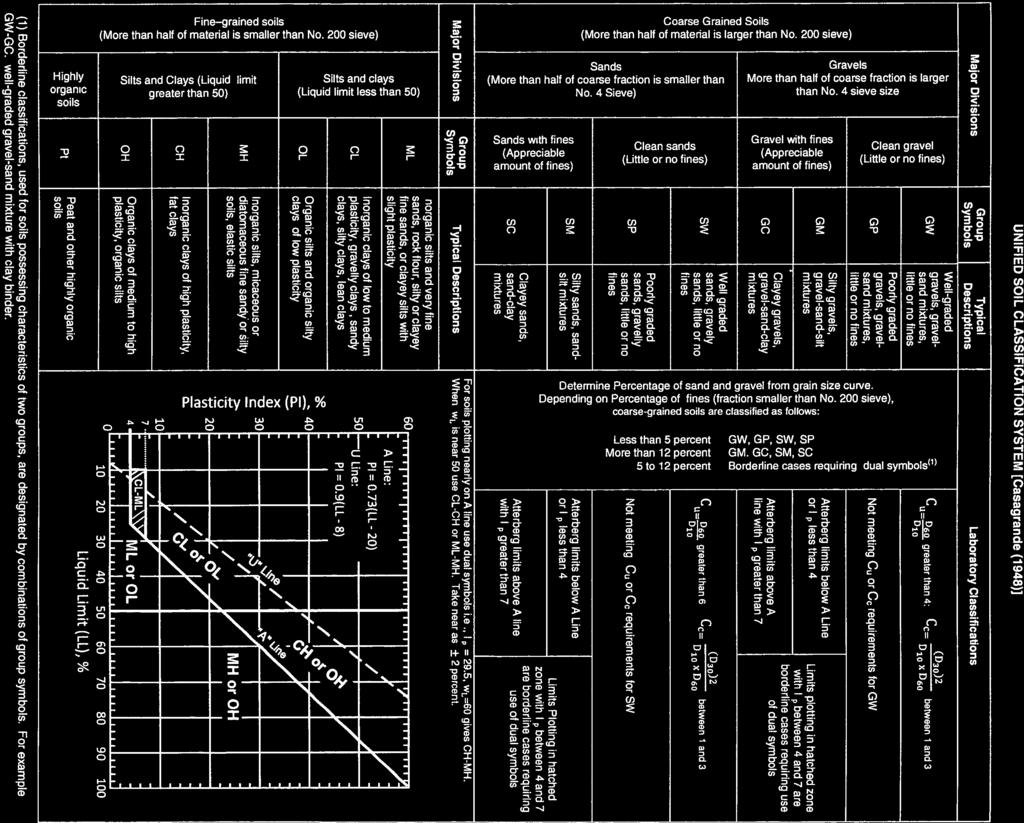
10 FIELD DESCRIPTION AND LOGGING SYSTEM FOR SOIL EXPLORATION GRANULAR SOILS (Sand, Gravel & Combinations) Density Very Loose Loose 6 to 10 Medium Dense 11 to 30 N (blows)* 5 or less Dense 31to 50 Very Dense 51 or more Relative Proportions Description Term Percent Trace 1-10 Little Some And Particle Size Identification Boulders 8 in. diameter or more Cobbles 3 to 8 in. diameter Gravel Coarse (C) 3 in. to ¾ in. sieve Fine (F) ¾ in. to No. 4 sieve Sand Coarse (C) No. 4 to No. 10 sieve (4.75mm-2.00mm) Medium (M) No. 10 to No. 40 sieve (2.00mm 0.425mm) Fine (F) No. 40 to No. 200 sieve ( mm) Silt/Clay Less Than a No. 200 sieve (<0.074mm) COHESIVE SOILS (Silt, Clay & Combinations) Consistency Very Soft Soft 4 to 5 Medium Stiff 6 to 10 Stiff 11 to 15 N (blows)* 3 or less Very Stiff 16 to 30 Hard 31 or more Plasticity Degree of Plasticity Plasticity Index None to Slight 0-4 Slight 5-7 Medium 8-22 High to Very High > 22 ROCK (Rock Cores) Rock Quality Designation (RQD), % Rock Quality Descripti on 0-25 Very Poor Poor Fair Good Excellent *N - Standard Penetration Resistance. Driving a 2.0" O.D., 1-3/8" I.D. sampler a distance of 18 inches into undisturbed soil with a 140 pound hammer free falling a distance of 30.0 inches. The number of hammer blows to drive the sampler through each 6 inch interval is recorded; the number of blows required to drive the sampler through the final 12 inch interval is termed the Standard Penetration Resistance (SPR) N-value. For example, blow counts of 6/8/9 (through three 6-inch intervals) results in an SPR N-value of 17 (8+9). Groundwater observations were made at the times indicated. Groundwater elevations fluctuate throughout a given year, depending on actual field porosity and variations in seasonal and annual precipitation.
11
HDD PA-IN RD (W-N57 and W-N56)
") HDD PA-IN-0048.0000-RD (W-N57 and W-N56) Given the design, the threat of inadvertent return has been reduced to the maximum extent practicable and in this case that threat is considered to be low. Implementing
HDD PA-IN-0048.0000-RD (W-N57 and W-N56) Given the design, the threat of inadvertent return has been reduced to the maximum extent practicable and in this case that threat is considered to be low. Implementing
HDD PA-HU WX (MP-140)
") HDD PA-HU-0020.0008-WX (MP-140) Given the design, the threat of inadvertent return has been reduced to the maximum extent practicable and in this case that threat is considered to be low. Implementing
HDD PA-HU-0020.0008-WX (MP-140) Given the design, the threat of inadvertent return has been reduced to the maximum extent practicable and in this case that threat is considered to be low. Implementing
HDD PA-YO RR (S-A22)
") HDD PA-YO-0063.0000-RR (S-A22) Given the design, the threat of inadvertent return has been reduced to the maximum extent practicable and in this case that threat is considered to be low. Implementing this
HDD PA-YO-0063.0000-RR (S-A22) Given the design, the threat of inadvertent return has been reduced to the maximum extent practicable and in this case that threat is considered to be low. Implementing this
HDD PA-CH RD (W-Q76, S-Q83, W-Q77, and S-Q86)
") HDD PA-CH-0088.0000-RD (W-Q76, S-Q83, W-Q77, and S-Q86) Given the design, the threat of inadvertent return has been reduced to the maximum extent practicable and based on geotechnical data, the threat
HDD PA-CH-0088.0000-RD (W-Q76, S-Q83, W-Q77, and S-Q86) Given the design, the threat of inadvertent return has been reduced to the maximum extent practicable and based on geotechnical data, the threat
HDD PA-CH RR (W-K18, W-K21, and AMTRAK railway)
") HDD PA-CH-0256.0000-RR (W-K18, W-K21, and AMTRAK railway) Given the design, the threat of inadvertent return has been reduced to the maximum extent practicable and in this case that threat is considered
HDD PA-CH-0256.0000-RR (W-K18, W-K21, and AMTRAK railway) Given the design, the threat of inadvertent return has been reduced to the maximum extent practicable and in this case that threat is considered
HDD PA-YO RR (S-A22)
") HDD PA-YO-63.-RR (S-A22) Given the design, the threat of inadvertent return has been reduced to the maximum extent practicable and in this case that threat is considered to be low. Implementing this design,
HDD PA-YO-63.-RR (S-A22) Given the design, the threat of inadvertent return has been reduced to the maximum extent practicable and in this case that threat is considered to be low. Implementing this design,
HDD PA-CH RD (Devon Drive, Biddle Drive, and Shoen Road)
") H PA-CH-0199.0000-R (evon rive, Biddle rive, and Shoen Road) Given the design, the threat of inadvertent return has been reduced to the maximum extent practicable and in this case that threat is considered
H PA-CH-0199.0000-R (evon rive, Biddle rive, and Shoen Road) Given the design, the threat of inadvertent return has been reduced to the maximum extent practicable and in this case that threat is considered
Attachment A HDD Table York County
 Attachment A HDD Table York County Drawing Name Drill Name County Township Drill Location Risk Assessment Level (Low / Medium / High) PA YO 0016.0000 RD.pdf Lewisberry Road York Fairview N: 40.192213 W:
HORIZONTAL DIRECTIONAL DRILL ANALYSIS HORSE VALLEY ROAD CROSSING PADEP SECTION 105 PERMIT NO. E PA-PE RD & PA-PE-0002.
 HORIZONTAL DIRECTIONAL DRILL ANALYSIS HORSE VALLEY ROAD CROSSING PADEP SECTION 105 PERMIT NO. E50-58 PA-PE-000.0000-RD & PA-PE-000.0000-RD-16 (SPLP HDD No. S-0157) HORSE VALLEY ROAD CROSSING PADEP SECTION
 Project: ITHACA-TOMPKINS REGIONAL AIRPORT EXPANSION Project Location: ITHACA, NY Project Number: 218-34 Key to Soil Symbols and Terms TERMS DESCRIBING CONSISTENCY OR CONDITION COARSE-GRAINED SOILS (major
APPENDIX C HYDROGEOLOGIC INVESTIGATION
 Figure B-5.7 Figure B-5.8 Preliminary Geotechnical and Environmental Report Appendix C Hydrogeologic Investigation APPENDIX C HYDROGEOLOGIC INVESTIGATION December 21, 2011 WESTSIDE SUBWAY EXTENSION PROJECT
 Photo 1 - Southerly view across 2700 parking lot toward existing building. Multi-residential building borders western side of property in upper right of view. Photo 2 - Southerly view across 2750 parking
B-1 BORE LOCATION PLAN. EXHIBIT Drawn By: 115G BROOKS VETERINARY CLINIC CITY BASE LANDING AND GOLIAD ROAD SAN ANTONIO, TEXAS.
 N B-1 SYMBOLS: Exploratory Boring Location Project Mngr: BORE LOCATION PLAN Project No. GK EXHIBIT Drawn By: 115G1063.02 GK Scale: Checked By: 1045 Central Parkway North, Suite 103 San Antonio, Texas 78232
Civil Engineering, Surveying and Environmental Consulting WASP0059.ltr.JLS.Mich Ave Bridge Geotech.docx
 2365 Haggerty Road South * Canton, Michigan 48188 P: 734-397-3100 * F: 734-397-3131 * www.manniksmithgroup.com August 29, 2012 Mr. Richard Kent Washtenaw County Parks and Recreation Commission 2330 Platt
APPENDIX C. Borehole Data
 APPENDIX C Borehole Data MAJOR DIVISIONS SOIL CLASSIFICATION CHART SYMBOLS GRAPH LETTER TYPICAL DESCRIPTIONS ADDITIONAL MATERIAL
Ardaman & Associates, Inc. Geotechnical, Environmental and Materials Consultants
 SUBSURFACE SOIL EXPLORATION 42-INCH FORCE MAIN REPLACEMENT CHIQUITA BOULEVARD S AND SW 34 TH STREET CAPE CORAL, LEE COUNTY, FLORIDA Ardaman & Associates, Inc. Geotechnical, Environmental and Materials
IN SITU SPECIFIC GRAVITY VS GRAIN SIZE: A BETTER METHOD TO ESTIMATE NEW WORK DREDGING PRODUCTION
 IN SITU SPECIFIC GRAVITY VS GRAIN SIZE: A BETTER METHOD TO ESTIMATE NEW WORK DREDGING PRODUCTION Nancy Case O Bourke, PE 1, Gregory L. Hartman, PE 2 and Paul Fuglevand, PE 3 ABSTRACT In-situ specific gravity
PRELIMINARY GEOTECHNICAL ENGINEERING REPORT. Proposed Re-Development 44 Old Worcester Road Charlton, Massachusetts. Prepared For:
 PRELIMINARY GEOTECHNICAL ENGINEERING REPORT Proposed Re-Development 44 Old Worcester Road Charlton, Massachusetts Prepared For: Meridian Associates, Inc. 500 Cummings Center, Suite 5950 Beverly, Massachusetts
3.0 SUMMARY OF FINDINGS
 AECOM 500 W Jefferson St. Suite 1600 Louisville, KY 40202 www.aecom.com 502-569-2301 tel 502-569-2304 fax October 17, 2018 Big Rivers Electric Corporation Sebree Generating Station 9000 Highway 2096 Robards,
ENGINEERING ASSOCIATES
 July 16, 211 Vista Design, Inc. 11634 Worcester Highway Showell, Maryland 21862 Attention: Reference: Dear Mr. Polk: Mr. Richard F. Polk, P.E. Geotechnical Engineering Report Charles County RFP No. 11-9
M E M O R A N D U M. Mr. Jonathan K. Thrasher, P.E., Mr. Ian Kinnear, P.E. (FL) PSI
 PSI") M E M O R A N D U M TO: FROM: Mr. Mark Schilling Gulf Interstate Engineering Mr. Jonathan K. Thrasher, P.E., Mr. Ian Kinnear, P.E. (FL) PSI DATE: November 11, 2014 RE: Summary of Findings Geotechnical
M E M O R A N D U M TO: FROM: Mr. Mark Schilling Gulf Interstate Engineering Mr. Jonathan K. Thrasher, P.E., Mr. Ian Kinnear, P.E. (FL) PSI DATE: November 11, 2014 RE: Summary of Findings Geotechnical
Depth (ft) USCS Soil Description TOPSOIL & FOREST DUFF
 USCS Soil Description TOPSOIL & FOREST DUFF") Test Pit No. TP-6 Location: Latitude 47.543003, Longitude -121.980441 Approximate Ground Surface Elevation: 1,132 feet Depth (ft) USCS Soil Description 0 1.5 1.5 5.0 SM 5.0 8.0 SM Loose to medium dense,
Test Pit No. TP-6 Location: Latitude 47.543003, Longitude -121.980441 Approximate Ground Surface Elevation: 1,132 feet Depth (ft) USCS Soil Description 0 1.5 1.5 5.0 SM 5.0 8.0 SM Loose to medium dense,
Geotechnical Data Report
 Geotechnical Data Report Downtown Greenville Future Conveyance Study December 1, 2015 Terracon Project No. 86155032 Prepared for: Prepared by: Terracon Consultants, Inc. December 1, 2015 561 Mauldin Road
GEOTECHNICAL REPORT. Matanuska-Susitna Borough. Parks Highway Connections Museum Drive. Matanuska-Susitna Borough, Alaska.
 Matanuska-Susitna Borough GEOTECHNICAL REPORT Parks Highway Connections Museum Drive Matanuska-Susitna Borough, Alaska March 2, 20 Prepared By: John Thornley, PE Geotechnical Engineer 333 Arctic Blvd.,
LEGEND ODOT CLASS A-3. A-3a. A-4a. A-6a. A-6b TOTAL VISUAL VISUAL VISUAL BORING LOCATION - PLAN VIEW
 PROJECT THE PROJECT CONSISTS IN PART OF CONSTRUCTING A SINGLE-SPAN BRIDGE ON RELOCATED SHUMWAY HOOW ROAD OVER THE CSXT RAILROAD. THE STRUCTURE AS ANNED, IS A SINGLE-SPAN STRUCTURE WITH MSE WAS AT THE ABUTMENTS.
Project No: 68R3056 Client: City of Frederick Project: RFQ 14-H Future North Side Water Tank City/State: 7516 Hayward Road, Frederick, MD
 Boring: SB-1 (1 of 1) Moist, brown to orange brown CLAY and SILT, trace sand with fine weathered rock fragments. POSSIBLE FILL. Dry, orange brown sandy SILT trace clay (SM-ML). RESIDUAL SOIL : Not Surveyed
Geotechnical Engineering Report
 Geotechnical Engineering Report Turner Turnpike Widening Bridge B Bridge Crossing: South 257 th West Avenue Creek County, Oklahoma June 1, 2016 Terracon Project No. 04155197 Prepared for: Garver, LLC Tulsa,
Limited Geotechnical Engineering Evaluation Classroom Additions Albany County Campus Laramie, Wyoming
 Limited Geotechnical Engineering Evaluation Classroom Additions Albany County Campus 2300 Missile Drive, Cheyenne, Wyoming 82001 Phone 307-635-0222 www.stratageotech.com Limited Geotechnical Engineering
 SOIL CLASSIFICATION CHART COARSE-GRAINED SOILS MORE THAN 50% RETAINED ON NO.200 SIEVE FINE-GRAINED SOILS 50% OR MORE PASSES THE NO.200 SIEVE PRIMARY DIVISIONS GRAVELS MORE THAN 50% OF COARSE FRACTION RETAINED
HORIZONTAL DIRECTIONAL DRILL ANALYSIS ARCH BISHOP/SOUTH CHESTER ROAD CROSSING PADEP SECTION 105 PERMIT NO.: E PA-CH-0421.
 HORIZONTAL DIRECTIONAL DRILL ANALYSIS ARCH BISHOP/SOUTH CHESTER ROAD CROSSING PADEP SECTION 05 PERMIT NO.: E5-86 PA-CH-04.0000-RD & PA-CH-04.0000-RD-6 (SPLP HDD No. S-054) ARCH BISHOP/SOUTH CHESTER ROAD
ATTACHMENT A PRELIMINARY GEOTECHNICAL SUMMARY
 ATTACHMENT A PRELIMINARY GEOTECHNICAL SUMMARY Kevin M. Martin, P.E. KMM Geotechnical Consultants, LLC 7 Marshall Road Hampstead, NH 0384 603-489-6 (p)/ 603-489-8 (f)/78-78-4084(m) kevinmartinpe@aol.com
Geotechnical Data Report
 Geotechnical Data Report ReWa Solar Farm at Durbin Creek Fountain Inn, South Carolina September 1, 2017 Terracon Project No. 86165043 Prepared for: Renewable Water Resources Greenville, South Carolina
LEGEND ODOT CLASS. A-4b. A-6a. A-6b TOTAL VISUAL WEATHERED SANDSTONE VISUAL BORING LOCATION - PLAN VIEW
 PROJECT THE PROJECT CONSISTS IN PART OF ACING TWO STRUCTURES, EASTBOUND AND WESTBOUND STRUCTURES, RESPECTIVELY FOR THE PROPOSED SR OVER BLUE ROAD (CR 9). THE TWO STRUCTURES AS ANNED, ARE SINGLE-SPAN STRUCTURES
PRELIMINARY GEOTECHNICAL REPORT. State College Redevelopment State College Borough, Centre County, Pennsylvania. CMT Laboratories File No.
 PRELIMINARY GEOTECHNICAL REPORT State College Redevelopment State College Borough, Centre County, Pennsylvania CMT Laboratories File No. 1638700 Prepared for: National Development Council One Battery Park
Horizontal Directional Drilling: An Approach to Design and Construction. Presenter: John Briand, PE Co-Author: Danielle Neamtu, PE
 Horizontal Directional Drilling: An Approach to Design and Construction Presenter: John Briand, PE Co-Author: Danielle Neamtu, PE Presentation Outline General HDD overview Conceptual-level evaluation Detailed
Report of Preliminary Geotechnical Exploration. CSO-012 Sewer Separation Cincinnati, Hamilton County, Ohio. February, 2011
 11242843_GeoTech_Preliminary - Feburary 2011_1/40 Report of Preliminary Geotechnical Exploration CSO-012 Sewer Separation Cincinnati, Hamilton County, Ohio February, 2011 11242843_GeoTech_Preliminary -
CONQUEST ENGINEERING LTD.
 CONQUEST ENGINEERING LTD. Geotechnical and Materials Engineers Concrete Technology, Blasting Consultants Construction Quality Assurance / Quality Control 8 Bluewater Road, Bedford, NS BB J6 Phone (9)85-7
New WW Hastings Hospital Geotechnical Investigation RFP Addendum #1
 88 E. Marshall Street, Suite 0 Tulsa, OK 76 98 8 9 Phone 98 8 798 FAX DATE: April 9, 0 ADDENDUM NO.: PROJECT: New WW Hastings Hospital BID PACKAGE NO: Geotechnical Investigation RFP SUBMITTED BY: CNCR
Preliminary Geotechnical Investigation Cadiz / Trigg County I-24 Business Park. Cadiz, Kentucky
 Environmental & Geoscience, LLC 834 Madisonville Road Hopkinsville, KY 440 70.44.000 FAX 70.44.8300 www.wedrill.com A member of Trinity Energy & Infrastructure Group, LLC Preliminary Geotechnical Investigation
DATA REPORT GEOTECHNICAL INVESTIGATION GALVESTON CRUISE TERMINAL 2 GALVESTON, TEXAS
 DATA REPORT GEOTECHNICAL INVESTIGATION GALVESTON CRUISE TERMINAL 2 GALVESTON, TEXAS SUBMITTED TO PORT OF GALVESTON 123 ROSENBERG AVENUE, 8TH FLOOR GALVESTON, TEXAS 77553 BY HVJ ASSOCIATES, INC. HOUSTON,
Pierce County Department of Planning and Land Services Development Engineering Section
 Page 1 of 7 Pierce County Department of Planning and Land Services Development Engineering Section PROJECT NAME: DATE: APPLICATION NO.: PCDE NO.: LANDSLIDE HAZARD AREA (LHA) GEOLOGICAL ASSESSMENT REPORT
PLATE 6 FEB G r o v e l a n d F l o o d w a l l - B o r e h o l e M a p. Legend. Groveland Floodwall Boreholes. Contour Lines.
 611 6 Defau FALS conto Conto DPLV lt Eurs20 01_to 3po Defau FALS conto Conto DPLV lt Eurs20 01_to 4po 612 Conto DPLV conto Defau FALS 01_to urs20 Elt po 5 Conto DPLV conto Defau FALS 01_to urs15 Elt po
Geotechnical Data Report
 Geotechnical Data Report Sabal Trail Transmission Hannahatchee Creek HDD Stewart County, Georgia for Gulf Interstate Engineering November 17, 2014 Geotechnical Data Report Sabal Trail Transmission Hannahatchee
B-1 SURFACE ELEVATION
 5A 5B LOGGED BY El. S. Bhangoo DRILLING CONTRACTOR Pitcher Drilling DRILLING METHOD Rotary Wash BEGIN DATE 12-14-12 SAMPLER TYPE(S) AND SIZE(S) (ID) SPT, MC BOREHOLE BACKFILL AND COMPLETION COMPLETION
Geotechnical Engineering Report
 Geotechnical Engineering Report Turner Turnpike Widening Polecat Creek Bridge (Bridge A) June 1, 2016 Terracon Project No. 04155197 Prepared for: Garver, LLC Prepared by: Terracon Consultants, Inc. TABLE
PRELIMINARY GEOTECHNICAL ENGINEERING REPORT
 PRELIMINARY GEOTECHNICAL ENGINEERING REPORT TOWN OF ASHLAND TOWN HALL 101 THOMPSON STREET ASHLAND, VIRGINIA JOB NUMBER: 39016 PREPARED FOR: PMA PLANNERS & ARCHITECTS 10325 WARWICK BOULEVARD NEWPORT NEWS,
APPENDIX A. Borehole Logs Explanation of Terms and Symbols
 APPENDIX A Borehole Logs Explanation of Terms and Symbols Page 153 of 168 EXPLANATION OF TERMS AND SYMBOLS The terms and symbols used on the borehole logs to summarize the results of field investigation
Geotechnical Engineering Study, Conifer Senior High School Football Field Improvements, Conifer, Colorado
 2390 South Lipan Street Denver, CO 80223 phone: (303) 742-9700 fax: (303) 742-9666 email: kadenver@kumarusa.com www.kumarusa.com Office Locations: Denver (HQ), Colorado Springs, Fort Collins, and Frisco,
GZA GeoEnvironmental, Inc.
 GZA BORING NO.: GZ-1 SHEET: 1 of 1 PROJECT NO: 9.223. Drilling Co.: Geologic Type of Rig: Skid Boring Location: See Plan H. Datum: See Plan Rig Model: Mudline : Foreman: Ray Eastwood CME -.8 Final Boring
 TP-1 N61E 0 DARK BROWN SANDY SILT (ML) stiff, wet with roots (Disturbed Surficial Soil) DEPTH (FEET) 5 REDDISH BROWN SANDSTONE intensely fractured, weak to friable, deeply weathered, tight (Franciscan
HORIZONTAL DIRECTIONAL DRILL ANALYSIS VALLEY ROAD CROSSING PADEP SECTION 105 PERMIT NO. E PA-DE RD and PA-DE-0046.
 HORIZONTAL DIRECTIONAL DRILL ANALYSIS VALLEY ROAD CROSSING PADEP SECTION 105 PERMIT NO. E2-524 PA-DE-0046.0000-RD and PA-DE-0046.0000-RD-16 (SPLP HDD No. S-0591) VALLEY ROAD CROSSING PADEP SECTION 105
Northern Colorado Geotech
 PRELIMINARY GEOTECHNICAL ENGINEERING REPORT PROPOSED CECIL FARMS DEVELOPMENT WELD COUNTY ROAD 7, BETWEEN ROADS 7 AND 7 SEVERANCE, COLORADO NORTHERN COLORADO GEOTECH PROJECT NO. 0-6 APRIL 0, 06 Prepared
APPENDIX E SOILS TEST REPORTS
 Otsego County, NY Site Work Specifications APPENDIX E SOILS TEST REPORTS Blue Wing Services, Inc. July 1, 2010 Blue Wing Services May 20, 2010 Page 2 the site, was not made available to Empire at this
Ardaman & Associates, Inc. Geotechnical, Environmental and Materials Consultants
 SUBSURFACE SOIL EXPLORATION DRAINAGE IMPROVEMENTS TO THE HENDRY COUNTY, FLORIDA Ardaman & Associates, Inc. Geotechnical, Environmental and Materials Consultants OFFICES Orlando, 88 S. Orange Avenue, Orlando,
Chapter 12 Subsurface Exploration
 Page 12 1 Chapter 12 Subsurface Exploration 1. The process of identifying the layers of deposits that underlie a proposed structure and their physical characteristics is generally referred to as (a) subsurface
CITY OF VALDEZ Project Title: East Pioneer Reconstruction Project No.: Contract No.: TO: All Recipients Date: April 14, 2014
 CITY OF VALDEZ Project Title: East Pioneer Reconstruction Project No.: 13-3-1.32 Contract No.: 11 TO: All Recipients Date: April 14, 214 SUBJECT: Addendum No.1 This seventeen (17) page Addendum forms a
Geotechnical Subsurface Exploration, Engineering Evaluation and Dam Visual Observation Sun Valley Drive Extension Roswell, Fulton County, GA
 Ranger Consulting, Inc. Geotechnical, Environmental, Drilling, Construction 3147 Martha Berry Highway, Rome, Georgia 165; Phone: 76-29-1782; Fax: 76-29-171 April 2, 215 Mr. Tommy Crochet, PE McGee Partners,
CITY OF CAPE CORAL NORTH 2 UTILITIES EXTENSION PROJECT CONTRACT 3
 GEOTECHNICAL REPORT CITY OF CAPE CORAL NORTH UTILITIES EXTENSION PROJECT CONTRACT City of Cape Coral Procurement Division Cultural Park Boulevard, nd Floor Cape Coral, FL ISSUED FOR BID VOLUME of GEOTECHNICAL
Geotechnical Data Report
 Geotechnical Data Report Emergency Bridge Package 6 Richland County, South Carolina May 12, 2016 SCDOT Project ID.: P029942, P029943, P029944 Terracon Project No. 73100L (Rev. 1) Prepared for: South Carolina
Geotechnical Engineering Report
 Geotechnical Engineering Report Turner Turnpike Widening Bridge D Bridge Crossing: South 209 th West Avenue Creek County, Oklahoma June 1, 2016 Terracon Project No. 04155197 Prepared for: Garver, LLC Tulsa,
Field Exploration. March 31, J-U-B ENGINEERS, Inc. 115 Northstar Avenue Twin Falls, Idaho Attn: Mr. Tracy Ahrens, P. E. E:
 March 31, 201 11 Northstar Avenue 83301 Attn: Mr. Tracy Ahrens, P. E. E: taa@jub.com Re: Geotechnical Data Report Preliminary Phase 1 Field Exploration Revision No. 1 Proposed Rapid Infiltration Basin
APPENDIX A GEOTECHNICAL REPORT
 The City of Winnipeg Bid Opportunity No. 529-2017 Template Version: C420170317 - RW APPENDIX A GEOTECHNICAL REPORT Quality Engineering Valued Relationships KGS Group 2017 Industrial Street Rehabilitation
GEOTECHNICAL ENGINEERING SERVICES REPORT
 GEOTECHNICAL ENGINEERING SERVICES REPORT BRIDGE OVER BIG CREEK APPROXIMATELY.8 MILES EAST OF THE INTERSECTION OF COUNTY ROAD EW1546 AND COUNTY ROAD 193 LEFLORE COUNTY, OKLAHOMA PROJECT No. J2-8616(5),
ADDENDUM 1 FISHER SLOUGH RESTORATION PROJECT SKAGIT COUNTY, WASHINGTON
 F I N A L A D D E N D U M 1 R E P O R T ADDENDUM 1 FISHER SLOUGH RESTORATION PROJECT SKAGIT COUNTY, WASHINGTON REPORT OF GEOTECHNICAL INVESTIGATION URS JOB NO. 3376186 Prepared for Tetra Tech Inc. 142
Log of Monitoring Well D58B
 Project: Motiva - Monitoring Well and Soil Boring Data Project Location: Delaware City Refinery Project Number: 20240412.W1000 Log of Monitoring Well D58B Sheet 1 of 7 Date(s) Drilled Drilling Method Drill
REPORT ON SLOPE STABILITY INVESTIGATION DON MILLS ROAD AND EGLINTON AVENUE EAST TORONTO, ONTARIO. Prepared for:
 REPORT ON SLOPE STABILITY INVESTIGATION DON MILLS ROAD AND EGLINTON AVENUE EAST TORONTO, ONTARIO Prepared for: TORONTO AND REGION CONSERVATION AUTHORITY Prepared By: SIRATI & PARTNERS CONSULTANTS LIMITED
PREPARED FOR MR. JOE WOOD CARTER & SLOOPE, INC PEAKE ROAD MACON, GEORGIA PREPARED BY
 SUBSURFACE EXPLORATION AND GEOTECHNICAL ENGINEERING EVALUATION MACON WATER AUTHORITY (MWA) SANITARY SEWER RELOCATION MACON, GEORGIA GEC PROJECT NO. 14077.2 PREPARED FOR MR. JOE WOOD CARTER & SLOOPE, INC.
HORIZONTAL DIRECTIONAL DRILL ANALYSIS AUGHWICK CREEK CROSSING PADEP SECTION 105 PERMIT NO.S: PA-HU WX & PA-HU WX-16 (SPLP HDD#
 HORIZONTAL DIRECTIONAL DRILL ANALYSIS AUGHWICK CREEK CROSSING PADEP SECTION 15 PERMIT NO.S: PA-HU-78.-WX & PA-HU-78.-WX-16 (SPLP HDD# S2-153) AUGHWICK CREEK CROSSING PADEP SECTION 15 PERMIT NO.S: PA-HU-78.-WX
Geotechnical Engineering Report
 Geotechnical Engineering Report Richland Creek Trunk Sewer Greenville, South Carolina March 31, 2014 Terracon Project No. 86145008 Prepared for: Renewable Water Resources Greenville, South Carolina Prepared
CONQUEST ENGINEERING LTD.
 CONQUEST ENGINEERING LTD. Geotechnical and Materials Engineers Concrete Technology, Blasting Consultants Construction Quality Assurance / Quality Control 8 Bluewater Road, Bedford, NS BB J6 Phone (9)85-7
Appendix 11-B Preliminary Geotechnical Investigation
 Appendix 11-B Preliminary Geotechnical Investigation 11.0 Soil, Geology, and Seismology PRELIMINARY SUBSURFACE EXPLORATION AND CONCEPTUAL FOUNDATION ENGINEERING REPORT CPV VALLEY ENERGY CENTER Wawayanda,
AN EMPLOYEE OWNED COMPANY
 CTL Engineering, Inc. 2860 Fisher Road, P.O. Box 4448, Columbus, Ohio 43204338 Phone: 614/2768123 Fax: 614/2766377 Email: ctl@ctleng.com AN EMPLOYEE OWNED COMPANY Consulting Engineers Testing Inspection
 FIGURES 200 200 200 SW 175TH AVE 350 SW SCHOLLS FERRY RD SW FRIENDLY LN Area 64 SW ROY ROGERS RD 300 250 SW ONEILL CT SW LUKE LN SW LEEDING LN SW TUSCANY ST SW 164TH AVE SW BULL MOUNTAIN RD SW 164TH AVE
Attachment B. Grain Size Distribution Curves
 Attachment B Grain Size Distribution Curves AREVA Resources Canada Inc. Kiggavik Project EIS December 11 Attachment B Technical Appendix 6A Surficial Geology and Terrain Client: Areva Project:
Geotechnical Investigation
 Geotechnical Investigation Slope Stability Analysis for the Existing Slope Southwest of the Proposed Condo Developments 50 Ann Street, Bolton, Ontario Prepared For: Brookfield Homes (Ontario) Limited GeoPro
Appendix G GEOLOGICAL INVESTIGATION
 Appendix G GEOLOGICAL INVESTIGATION JOB NUMBER: 3268.001 DATE: 10-14-13 BY: CC SITE 0 2000 1"=2000' VICINITY MAP CARGILL PARCEL HICKORY STREET AND ENTERPRISE DRIVE NEWARK, CALIFORNIA FOR
UAS Student Residence
 General Notes, Abbreviations and Symbols C100 MATCH LINE - SEE SHEET L6 Existing Site Topographic Conditions C101 MATCH LINE - SEE SHEET L5 Existing Site Topographic Conditions C102 DEPTH(FT.) 5 FROZEN
Boreholes. Implementation. Boring. Boreholes may be excavated by one of these methods: 1. Auger Boring 2. Wash Boring 3.
 Implementation Boreholes 1. Auger Boring 2. Wash Boring 3. Rotary Drilling Boring Boreholes may be excavated by one of these methods: 4. Percussion Drilling The right choice of method depends on: Ground
Geotechnical Engineering Report
 Geotechnical Engineering Report Single-Span Bridge North Western Road & Hall of Fame Avenue August 25, 2015 Terracon Project No. 03155156 Prepared for: Olsson Associates Prepared by: Terracon Consultants,
APÉNDICE F. Evaluación Geotécnica
 APÉNDICE F Evaluación Geotécnica REPORT ON GEOTECHNICAL INVESTIGATION FOR PROPOSED LAGUNA DEL MAR PLAZA PROJECT ASHFORD AVE. SAN JUAN, PUERTO RICO GUTIERREZ - LATIMER - C.S.P. MR. ROBERTO CACHO I LAGUNA
ENCE 3610 Soil Mechanics. Site Exploration and Characterisation Field Exploration Methods
 ENCE 3610 Soil Mechanics Site Exploration and Characterisation Field Exploration Methods Geotechnical Involvement in Project Phases Planning Design Alternatives Preparation of Detailed Plans Final Design
BRIDGE FOUNDATION INVESTIGATION
 Jackson Lake Road Bridge over Mackey Creek Henry County, Georgia BRIDGE FOUNDATION INVESTIGATION PROJECT NUMBER LOCATION (See Map) 8934 Jackson Lake Road Bridge over Mackey Creek, Henry County, Georgia
Ardaman & Associates, Inc. Geotechnical, Environmental and Materials Consultants
 SUBSURFACE SOIL EXPLORATION ANALYSIS AND RECOMMENDATIONS LELY AREA STORMWATER IMPROVEMENT PROJECT (LASIP) COUNTY BARN ROAD AND WING SOUTH CHANNELS NAPLES, COLLIER CO., FLORIDA Ardaman & Associates, Inc.
December 5, Junction Gateway, LLC 7551 W. Sunset Boulevard #203 Los Angeles, CA Mr. James Frost P: Dear Mr.
 December 5, 2014 Junction Gateway, LLC 7551 W. Sunset Boulevard #203 90046 Attn: Re: Mr. James Frost P: 323.883.1800 Geotechnical Update Letter Sunset & Effie Mixed Use Development 4301 to 4311 Sunset
Geotechnical Recommendations for Proposed Additions to the Three Mile Creek Severe Weather Attenuation Tank Project
 TECHNICAL MEMORANDUM Geotechnical Recommendations for Proposed Additions to the Three Mile Creek Severe Weather Attenuation Tank Project PREPARED FOR: PREPARED BY: DATE: June 28, 218 PROJECT NUMBER: 697482
Hydro One (Sept 2014) Hydro One (Sept 2014) Hydro One (Sept 2014)
 Hydro One (Sept 2014) Hydro One (Sept 2014)") TABLE 1 WELL CONSTRUCTION DETAILS MOE WWR No Well ID Location Installation Date Status Easting Coordinates Northing Source Elevation Screened Interval Screened Material Borehole Well Stick-up Ground Top
TABLE 1 WELL CONSTRUCTION DETAILS MOE WWR No Well ID Location Installation Date Status Easting Coordinates Northing Source Elevation Screened Interval Screened Material Borehole Well Stick-up Ground Top
GEOTECHNICAL INVESTIGATION REPORT
 GEOTECHNICAL INVESTIGATION REPORT SOIL INVESTIGATION REPORT FOR STATIC TEST FACILITY FOR PROPELLANTS AT BDL, IBRAHIMPATNAM. Graphics Designers, M/s Architecture & Engineering 859, Banjara Avenue, Consultancy
Correlation of unified and AASHTO soil classification systems for soils classification
 Journal of Earth Sciences and Geotechnical Engineering, vol. 8, no. 1, 2018, 39-50 ISSN: 1792-9040 (print version), 1792-9660 (online) Scienpress Ltd, 2018 Correlation of unified and AASHTO classification
APPENDIX B: BORING LOGS
 New Orleans Levee Systems Independent Levee Hurricane Katrina Investigation Team July, 6 APPENDIX B: BORING S As part of the field investigation 9 borings were performed at the sites of interest, as listed
SUBSURFACE EXPLORATION REPORT FOR THE MARITIME INFRACTURE REHABILITATION AT WHISKEY ISLAND BULK TERMINAL CLEVELAND, OHIO PGI PROJECT NO.
 SUBSURFACE EXPLORATION REPORT FOR THE MARITIME INFRACTURE REHABILITATION AT WHISKEY ISLAND BULK TERMINAL CLEVELAND, OHIO PGI PROJECT NO. G1G PREPARED FOR KS ASSOCIATES, INC. PREPARED BY PRO GEOTECH, INC.
June 9, R. D. Cook, P.Eng. Soils Engineer Special Services Western Region PUBLIC WORKS CANADA WESTERN REGION REPORT ON
 PUBLIC WORKS CANADA WESTERN REGION REPORT ON GEOTECHNICAL INVESTIGATION PROPOSED MARTIN RIVER BRIDGE MILE 306.7 MACKENZIE HIGHWAY Submitted by : R. D. Cook, P.Eng. Soils Engineer Special Services Western
NAPLES MUNICIPAL AIRPORT
 NAPLES MUNICIPAL AIRPORT NAPLES MUNICIPAL AIRPORT (APF) TAXIWAY D REALIGNMENT AND DRAINAGE IMPROVEMENTS NORTH QUADRANT ADDENDUM NUMBER TWO March, The following Addendum is hereby made a part of the Plans
PARQUE COLON AGUADILLA (LAND PROPERTY OF MUNICIPIO AGUADA) LOT PROPERTY OF SUNC. ESTEVEZ BW-1 BW-5 BW-2 DB1 BW-3 DB2 BW-4 DB3 GWS-1
 LOT PROPERTY OF SUNC. ESTEVEZ BW-1 BW-5 BW-2 DB1 BW-3 DB2 BW-4 DB3 GWS-1") N 64650 N 64600 N 64550 N 64500 N 64450 N 64400 N 64350 N 64300 N 64250 N 64200 N 64150 N 64100 N 64050 N 64000 N 63950 N 63900 N 63850 N 63800 N 63750 N 63700 N 63650 N 63600 N 63550 N 63500 N 63450 N
N 64650 N 64600 N 64550 N 64500 N 64450 N 64400 N 64350 N 64300 N 64250 N 64200 N 64150 N 64100 N 64050 N 64000 N 63950 N 63900 N 63850 N 63800 N 63750 N 63700 N 63650 N 63600 N 63550 N 63500 N 63450 N
REPORT OF PRELIMINARY SUBSURFACE EXPLORATION. VCU Basketball Practice Facility 1300/1328 West Marshall Street City of Richmond, Virginia.
 REPORT OF PRELIMINARY SUBSURFACE EXPLORATION VCU Basketball Practice Facility 100/18 West Marshall Street City of Richmond, Virginia For Mr. Carl F. Purdin, AIA Assistant Director of Design Services VCU
Geotechnical Engineering Report
 Geotechnical Engineering Report SH-9 Bridge over Wewoka Creek Hughes County, Oklahoma Job Piece No. 27059(04) July 16, 2015 Terracon Project No. 04125055 Prepared for: Holloway, Updike, and Bellen, Inc.
Geotechnical Investigation Juneau Seawalk - Taku Fisheries to Miner s Wharf Juneau, Alaska DM&A Job No
 Duane Miller & Associates 5821 Arctic Boulevard, Suite A Anchorage, AK 99518-1654 (907) 644-3200 Fax 644-0507 Arctic & Geotechnical Engineering May 4, 2006 Tetra Tech/KCM, Inc. 1971 First Avenue Seattle,
Fauquier County Cedar Lee Middle School Safety Routes to School Bealeton, Virginia
 Geotechnical Report Fauquier County Cedar Lee Middle School Safety Routes to School Project Number: GEO 121913.08 April 30, 2015 Prepared for McCormick Taylor, Inc. 113 Mill Place Parkway, Unit 103 Verona,
February 16, 2015 File No Ms. Robin Yates TRC Engineers Inc N. Fresno Street, Suite 200 Fresno, California 93710
 February 16, 2015 File No. 20152738 Ms. Robin Yates TRC Engineers Inc. 6051 N. Fresno Street, Suite 200 Fresno, California 93710 SUBJECT: Geotechnical Design Memorandum Fresno BPMP Scour Countermeasure
REPORT OF PRELIMINARY GEOTECHNICAL SITE INVESTIGATION KERSHAW COUNTY EXIT 87 OFFICE PARK. ELGIN, SOUTH CAROLINA S&ME Project No.
 REPORT OF PRELIMINARY GEOTECHNICAL SITE INVESTIGATION KERSHAW COUNTY EXIT 87 OFFICE PARK ELGIN, SOUTH CAROLINA S&ME Project No. 1611-04-450 Prepared For: KERSHAW COUNTY ECONOMIC DEVELOPMENT OFFICE Post
REPORT. Explorations and Geotechnical Engineering Services
 REPORT September 9, 2015 15-0690 S Explorations and Geotechnical Engineering Services Runway 35 Localizer Slope Reconstruction MHT Airport Goffs Falls Road Manchester, New Hampshire PREPARED FOR: Jacobs