Quantitative Seismic Geomorphology of Fluvial Systems of the Pleistocene to Recent in the Malay Basin, Southeast Asia*
|
|
|
- Corey Ward
- 6 years ago
- Views:
Transcription
1 Quantitative Seismic Geomorphology of Fluvial Systems of the Pleistocene to Recent in the Malay Basin, Southeast Asia* Faisal Alqahtani 1, Christopher Jackson 1, Howard Johnson 1, Alex Davis 2, and Ammar Ahmad 1 Search and Discovery Article #41032 (2012)** Posted October 8, 2012 *Adapted from oral presentation at AAPG Annual Convention and Exhibition, Long Beach, California, USA, April 22-25, 2012 **AAPG 2012 Serial rights given by author. For all other rights contact author directly. 1 Department of Earth Science & Engineering, Imperial College, London, SW7 2BP, UK (falqahtani@kau.edu.sa) 2 Exprodat, 25 Floral Street, London, WC2E 9DS, UK Abstract Outcrop data and satellite imagery of modern systems typically provide only 2D and quasi-3d data on the geometry, orientation and dimensions of reservoir sand bodies, which are critical elements for the construction of geologically meaningful, 3D, object-based reservoir models. 3D seismic data can also provide important data, although the ability to collate large, statistically valid datasets is limited by the tools that are available in standard seismic interpretation software packages. We present a new methodology for quantifying planform geometries and dimensions of fluvial channel sand bodies that are imaged in shallow, near sea-bed, 3D seismic datasets. Data capture has been semi-automated using ArcGIS, which allows fast and efficient mapping of these morphometric parameters. We have applied this methodology to a Pliocene-Pleistocene fluvial succession that is spectacularly imaged on a high-resolution, regionally extensive, 3D seismic survey from the Malay Basin, Southeast Asia, and we focus on the quantification of key channel parameters, such as meander channel width, meander belt width and meander wavelength. We demonstrate that the lower part of each seismic unit is characterised by wide, deep, lowsinuosity channels, which pass gradually upwards into narrower and thinner, high-sinuosity channels at the top. We speculate that a combination of sea-level changes and fluctuations in discharge and sediment load, both of which may have been linked to climate variations, may have controlled the observed stratigraphic organisation. Empirical equations developed on modern rivers have been tested on the channels identified in this study. The results suggest that existing empirical equations cannot be applied to describe the relationships between geometric parameters that characterise the fluvial channels in this particular geological setting. Hence, several new empirical relationships are proposed; they may be more applicable for predicting fluvial channel dimensions in humid-tropical settings. Our data have been used to constrain reservoir models for the deeper, oil- and gas-producing Miocene succession, which contains a large proportion of fluvial channel reservoirs but which is less clearly imaged on 3D seismic data. The study highlights the value of using high-quality, near sea-bed 3D seismic volumes for extracting analogue data on sand-body dimensions; datasets such as these are increasingly accessible to researchers from many parts of the world.
2 References Darmadi, Y., B.J. Willis, and S.L. Dorobek, 2007, Three-dimensional seismic architecture of fluvial sequences on the low gradient Sunda Shelf, offshore Indonesia: JSR, v. 77/3, p Kiel, B.A., L.J. Wood, 2010, Correlations among siesmic attributes and incised valley thicknesses in recent stratigraphy of the Sunda Shelf, Indonesia, in L.J. Wood, T.T. Simo, and N.C. Rosen, (eds.), Seismic imaging of depositional and geomorphic systems: GCSSEPM Foundation Annual Bob F. Perkins Research Conference, v. 30, p. 23. Leeder, M.R., 1973, Fluviatile fining-upwards cycles and the magnitude of palaeochannels: Geological Magazine, v. 110/3, p Lorenz, J.C., D.M. Heinze, J.A. Clark, and C.A. Searls, 1985, Determination of widths of meander-belt sandstone reservoirs from vertical downhole data, Mesaverde Group, Piceance Creek Basin, Colorado: AAPG Bulletin, v. 69/5, p Madon, M.B.H., M.J.B., Hoesni, M.B. Ahmad, and P. Abolins, 1999, Malay Basin: The Petroleum Geology and Resources of Malaysia, p. 171, Miall, A.D., 2002, Architecture and sequence stratigraphy of pleistocene fluvial systems in the Malay Basin, based on seismic time-slice analysis: AAPG Bulletin, v. 88/7, p Posamentier, H.W., 2001, Lowstand alluvial bypass sytems: Incised vs. Unincised: AAPG Bulletin, v. 85/10, p Reijenstein, H.M., H.W. Posamentier, and J.P. Bhattacharya, 2011, Seismic geomorphology and high-resolution seismic stratigraphy of inner-shelf fluvial, estuarine, deltaic, and marine sequqnces, Gulf of Thailand: AAPG Bulletin, v. 95/11, p Sathiamurthy, E., and H.K. Voris, 2006, Maps of Holocene Sea Level Transgression and Submerged Lakes on the Sunda Shelf: The Natural History Journal of Chulalongkorn University, Supplement 2, p Voris, H.K., 2000, Maps of Pleistocene sea levels in Southeast Asia: shorelines, river systems and time durations: Journal of Biogeography, v. 27, p
3
4

5 Presenter s notes: The Sunda Shelf has an area of 125,000 km2, making it the largest epicontinental area in the world that is located within in a tropical humid climate setting: The Sunda Shelf was exposed as far as the 200 m bathymetry level during the late Pleistocene lowstand of sea level. It now has an average water depth of 70 m and is characterised by an extremely low gradient (<0.1 degree). Study area is in the centre of the Malay Basin, which is one of several deeply buried Tertiary basins on the large Sunda Shelf: 500 km long & 250 km wide. Sunda Shelf end member: extremely wide, very high rates of sediment supply and high biodiversity. Previous studies highlight the following factors: 1. Non-glaciated, 2. Humid-tropical climate, 3. Large epicontinental area (tectonicallyinactive), 4. Hinterland areas (e.g., Himalayas) tectonically active, and 5. Characterised by very high erosion & sedimentation rates.

6 Presenter s notes: The Malay Basin is a typical SE Asian basin that was initiated during Early Tertiary rifting, followed by thermal subsidence and inversion. From the late Pliocene/Pleistocene onwards it has been tectonically quiescent.

7 Presenter s notes: Late Cenozoic basin-fill comprises Oligocene fluvial-lacustrine deposits that are overlain by coastal plain and marginal marine sediments. Productive oil and gas reservoirs occur mainly within the Miocene. The gross depositional environment of the Miocene continued into the Pliocene, and throughout this time the area was characterised by a humid tropical climate, without glaciation. Hence, sedimentary environments in the shallow sub-seabed part of the stratigraphy, which is Pliocene-Recent in age, mimics the deeper productive Miocene reservoirs.
8

9 Presenter s notes: Study area based on 10 separate 3D surveys merged into a single interpretable volume. They have different acquisition and processing characteristics.

10 Presenter s notes: (I) Uninterpreted and (II) interpreted regional seismic section through the 3D seismic dataset illustrating the seismic units and the bounding surfaces. Cross-sectional profiles of the largest, seismically-detectable, channel systems are shown: white u and v shapes plus two large IVF. The main bounding surfaces are characterised by prominent incisions. Truncation at base of Unit A.

11 Presenter s notes: (I) Uninterpreted and (II) interpreted seismic section through the 3D seismic dataset illustrating the Units and the bounding surfaces. Note the seismic expression within the deep incision is different from the adjacent strata. V -shaped channel morphology associated with accretion surface is also shown
 & cross-sectional geometry (U- and V- shapes).")
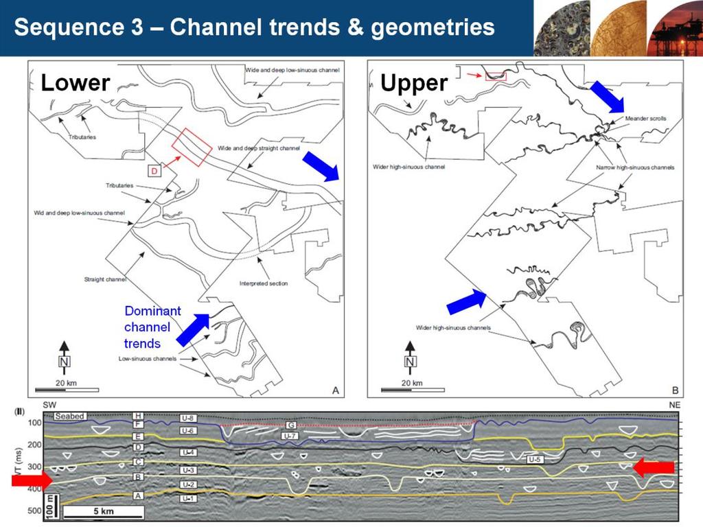
12 Presenter s notes: 6 different channel types identified from width (W), depth (D), sinuosity (SI) & cross-sectional geometry (U- and V- shapes). Vertical resolution limit at c. 7-8 m.
 is characterised by narrow, shallow, u-shaped, with a clear erosional base and sub-seismic infill.")
13 Presenter s notes: Type 3 (Type 1 not shown) is characterised by u-shaped, infilled with variable-amplitude, laterally continuous seismic reflections. These types are common in association with major low-sinuosity channels. Type 4 (Type 2 not shown) is characterised by narrow, shallow, u-shaped, with a clear erosional base and sub-seismic infill. These types are common in association with medium-scale, high-sinuosity channels.
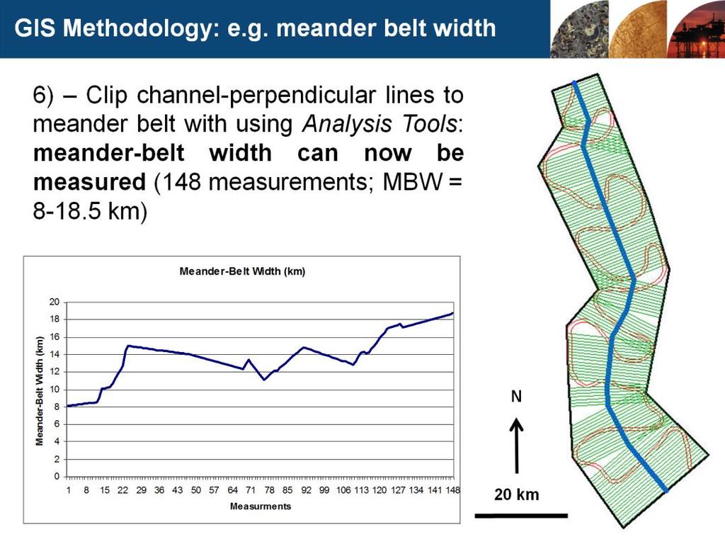
 = up to 90 m. Width of the valley - up to 18.5 km.")
14 Presenter s notes: Erosional relief of the F reflector (base sequence 7) = up to 90 m. Width of the valley - up to 18.5 km.

15

16 Presenter s notes: This is the first of three summary slides.
17

18

19 Presenter s notes: Work by Voris and others have defined a network of fluvial systems based on high-resolution sea-bed bathmetry data; the Chao Praya-Johore drainage system, the largest system, trended along the axis of the earlier rift/sag basins.

20
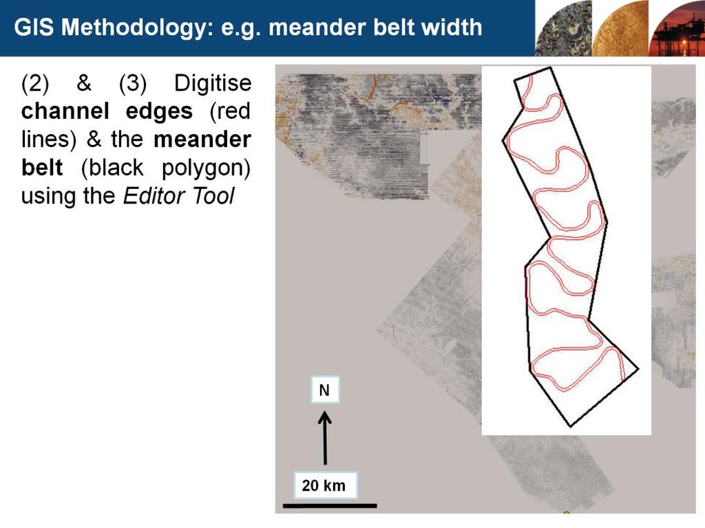
21 Presenter s notes: Seismic interpretation software is not designed to make accurate and spatially-constrained measurements of fluvial channel dimensions. Existing methods for measuring fluvial channels dimensions are time-consuming and inaccurate. Two new methods presented here utilise seismic time-slices and interpreted seismic horizons: (1) Easier, (2) More accurate, & (3) Faster. 1) Schematic drawing showing the methodology adopted to measure the morphometric parameters of the fluvial systems (A) and the channel orientation (B). The morphometric parameters include channel width (CW), channel depth (CD), meander belt width (MBW), radius of curvature (RC), meander wavelength (ML), and channel length (La). Sinuosity (SI) is calculated as the length along the channel course (La) divided by the meander wavelength (ML). The channel orientation is determined by defining the azimuth of a line that has been drawn between two points of the upstream and downstream reaches. 2) Schematic drawing showing the methodology adopted to measure the channel depth (CD) from the seismic section. In this study, the channel depth is measured as the maximum thickness of channel incisions, which is the vertical distance between the top and base of the incision feature.

22
23

24
25
26 Presenter notes: (a) Cross-plot of channel depth (CD) versus channel width (CW) shows that as CW increases so does CD. This relationship allows for a new empirical equation to be developed (dashed-line). The developed equation is CW=0.3(CD^2.54). (B) Approximately 130 channels were measured in detail.
 corresponding to the low-sinuousity channels (Group-2), and another with a larger slope representing highly")
27 Presenter s notes: Cross-plot of channel width (CW) versus meander belt width (MBW). This graph shows a direct relationship whereby MBW increases as CW increases (A). In addition, it shows two main poupulations: one with small slope (rate of increase) corresponding to the low-sinuousity channels (Group-2), and another with a larger slope representing highly sinuous channels (Group-3).

28

29

30
Bulletin of Earth Sciences of Thailand
 Quantitative Seismic Geomorphology of Early Miocene to Pleistocene Fluvial System of Northern Songkhla Basin, Gulf of Thailand Oanh Thi Tran Petroleum Geoscience Program, Department of Geology, Faculty
Seismic Geomorphology in the Late Cenozoic Depositional Evolution of the Gulf of Thailand
 Research article Seismic Geomorphology in the Late Cenozoic Depositional Evolution of the Gulf of Thailand Worawat Maharernthong, Piyaphong Chenrai* and Montri Choowong Department of Geology, Faculty of
Southern Songkhla Basin, Gulf of Thailand
 Architecture and Depositional Environment of Fluvial Systems of Southern Songkhla Basin, Gulf of Thailand Toan Manh Do Petroleum Geoscience Program, Department of Geology, Faculty of Science, Chulalongkorn
Controls on clastic systems in the Angoche basin, Mozambique: tectonics, contourites and petroleum systems
 P2-2-13 Controls on clastic systems in the Angoche basin, Mozambique: tectonics, contourites and petroleum systems Eva Hollebeek, Olivia Osicki, Duplo Kornpihl Schlumberger, London, UK Introduction Offshore
Bulletin of Earth Sciences of Thailand
 Depositional Environments and Stratigraphic Development of the Grand Taman Sari Circuit Outcrop: an Analogue for Transgressive Mahakam Delta Successions Ridha Santika Riadi Petroleum Geoscience Program,
Case Study of the Structural and Depositional-Evolution Interpretation from Seismic Data*
 Case Study of the Structural and Depositional-Evolution Interpretation from Seismic Data* Yun Ling 1, Xiangyu Guo 1, Jixiang Lin 1, and Desheng Sun 1 Search and Discovery Article #20143 (2012) Posted April
Effects of Tides on Deltaic Deposition: Causes and Responses*
 Effects of Tides on Deltaic Deposition: Causes and Responses* Piret Plink-Bjorklund 1 Search and Discovery Article #50626 (2012)** Posted June 25, 2012 *Adapted from oral presentation at AAPG Annual Convention
Meandering Miocene Deep Sea Channel Systems Offshore Congo, West Africa
 Meandering Miocene Deep Sea Channel Systems Offshore Congo, West Africa S. Baer* (PGS), J. E. Comstock (PGS), K. Vrålstad (PGS), R. Borsato (PGS), M. Martin (PGS), J.P. Saba (SNPC), B. Débi-Obambé (SNPC)
Nature, origin and evolution of a Late Pleistocene incised valley-fill,
 Received Date : 25-Mar-2014 Revised Date : 17-Nov-2014 Accepted Date : 17-Dec-2014 Article type : Original Manuscript Nature, origin and evolution of a Late Pleistocene incised valley-fill, Sunda Shelf,
Bulletin of Earth Sciences of Thailand. Controls on Reservoir Geometry and Distribution, Tantawan Field, Gulf of Thailand.
 Controls on Reservoir Geometry and Distribution, Tantawan Field, Gulf of Thailand Atchara Praidee Petroleum Geoscience Program, Department of Geology, Faculty of Science, Chulalongkorn University, Bangkok
Seismic Attributes and Their Applications in Seismic Geomorphology
 Academic article Seismic Attributes and Their Applications in Seismic Geomorphology Sanhasuk Koson, Piyaphong Chenrai* and Montri Choowong Department of Geology, Faculty of Science, Chulalongkorn University,
Holocene Lower Mississippi River Avulsions: Autogenic Versus Allogenic Forcing*
 Holocene Lower Mississippi River Avulsions: Autogenic Versus Allogenic Forcing* Eric Prokocki 1,2 Search and Discovery Article #50330 (2010) Posted October 14, 2010 *Adapted from oral presentation at AAPG
Sedimentary Cycle Best Practice: Potential Eo-Oligocene Sediments in Western Indonesia*
 Sedimentary Cycle Best Practice: Potential Eo-Oligocene Sediments in Western Indonesia* Mellinda Arisandy 1 and I Wayan Darma 1 Search and Discovery Article #11008 (2017)** Posted November 6, 2017 *Adapted
Arthur Saller 1. Search and Discovery Article #51393 (2017)** Posted June 26, Abstract
** Posted June 26, Abstract") PS Mixed Carbonates and Siliciclastics North of the Mahakam Delta, Offshore East Kalimantan, Indonesia* Arthur Saller 1 Search and Discovery Article #51393 (2017)** Posted June 26, 2017 *Adapted from poster
PS Mixed Carbonates and Siliciclastics North of the Mahakam Delta, Offshore East Kalimantan, Indonesia* Arthur Saller 1 Search and Discovery Article #51393 (2017)** Posted June 26, 2017 *Adapted from poster
Drainage Systems in Rift Basins: Implications for Reservoir Quality*
 Drainage Systems in Rift Basins: Implications for Reservoir Quality* Stephen Schwarz 1 and Lesli Wood 2 Search and Discovery Article #30477 (2016)** Posted December 5, 2016 *Adapted from oral presentation
Depositional Sequences Sequences
 Depositional Sequences Transgressive and Regressive packages can be bound by unconformities Because sediment can only be preserved during net aggradation and progradation All other times there is either
OUTCROP! CHARACTERISATION! OF! TRANSGRESSIVE! SANDSTONE! RESERVOIRS:! QUANTITATIVE!COMPARISON!OF!OUTCROP!ANALOGUES!
 OUTCROP CHARACTERISATION OF TRANSGRESSIVE SANDSTONE RESERVOIRS: QUANTITATIVECOMPARISONOFOUTCROPANALOGUES OLIVER D. JORDAN 1, PETER J. SIXSMITH 2, GARY J. HAMPSON, SANJEEV GUPTA & HOWARDD.JOHNSON DepartmentofEarthScienceandEngineering,ImperialCollegeLondon,SouthKensington
FACIES ANALYSIS AND STRATIGRAPHIC SEQUENCE OF THE NORTHEAST MALAY BASIN, OFFSHORE TERENGGANU, MALAYSIA
 FACIES ANALYSIS AND STRATIGRAPHIC SEQUENCE OF THE NORTHEAST MALAY BASIN, OFFSHORE TERENGGANU, MALAYSIA Noorzamzarina Sulaiman, Umar Hamzah and Abdul Rahim Samsudin Department of Geology, School of Environmental
A.K. Khanna*, A.K. Verma, R.Dasgupta, & B.R.Bharali, Oil India Limited, Duliajan.
 P-92 Application of Spectral Decomposition for identification of Channel Sand Body in OIL s operational area in Upper Assam Shelf Basin, India - A Case study A.K. Khanna*, A.K. Verma, R.Dasgupta, & B.R.Bharali,
Sequence Stratigraphy. Historical Perspective
 Sequence Stratigraphy Historical Perspective Sequence Stratigraphy Sequence Stratigraphy is the subdivision of sedimentary basin fills into genetic packages bounded by unconformities and their correlative
Stratigraphic Architecture and Key Stratigraphic Surfaces Formed by Punctuated Flow Events - An Experiment on Fluviodeltaic Responses*
 Click to view movie-steady State Click to view movie-high Flow 1 Click to view movie- Low Flow 1 Click to view movie-high Flow Click to view movie-low Flow Note: If video clips do not function properly,
Kilometre-Scale Uplift of the Early Cretaceous Rift Section, Camamu Basin, Offshore North-East Brazil*
 Kilometre-Scale Uplift of the Early Cretaceous Rift Section, Camamu Basin, Offshore North-East Brazil* Iain Scotchman 1 and Dario Chiossi 2 Search and Discovery Article #50183 (2009) Posted May 20, 2009
Bulletin of Earth Sciences of Thailand. Evaluation of the Petroleum Systems in the Lanta-Similan Area, Northern Pattani Basin, Gulf of Thailand
 Evaluation of the Petroleum Systems in the Lanta-Similan Area, Northern Pattani Basin, Gulf of Thailand Sirajum Munira Petroleum Geoscience Program, Department of Geology, Faculty of Science, Chulalongkorn
Sequence Stratigraphy as a tool for water resources management in alluvial coastal aquifers: application to the Llobregat delta (Barcelona, Spain)
") Sequence Stratigraphy as a tool for water resources management in alluvial coastal aquifers: application to the Llobregat delta (Barcelona, Spain) Desiré Gàmez Torrent December 2007 CHAPTER 1: Introduction
Sequence Stratigraphy as a tool for water resources management in alluvial coastal aquifers: application to the Llobregat delta (Barcelona, Spain) Desiré Gàmez Torrent December 2007 CHAPTER 1: Introduction
Lecture 19: Fluvial Facies
 GEOL 440 Sedimentology and stratigraphy: processes, environments and deposits Lecture 19: Fluvial Facies Aims Examine controls on alluvial channel pattern List the types of channel pattern Examine meandering
Structural Framework and Deep-Marine Depositional Environments of Miocene- Pleistocene Sequence in Western Offshore Myanmar
 P-58 Structural Framework and Deep-Marine Depositional Environments of Miocene- Pleistocene Sequence in Western Offshore Myanmar Mukesh Jain*, Prabal Shankar Das, Bidesh Bandyopadhyay Summary The western
Deep Water Systems and Sequence Stratigraphy. By: Matt Kyrias, Chris Majerczyk, Nick Whitcomb, Wesley Vermillion
 Deep Water Systems and Sequence Stratigraphy By: Matt Kyrias, Chris Majerczyk, Nick Whitcomb, Wesley Vermillion Contents Gravity Flow Depositional Elements Defined References NOTE: Source uses seismic
Structural Style and Tectonic Evolution of the Nakhon Basin, Gulf of Thailand
 Structural Style and Tectonic Evolution of the Nakhon Basin, Gulf of Thailand Piyaphong Chenrai Petroleum Geoscience Program, Department of Geology, Faculty of Science, Chulalongkorn University, Bangkok
The Late Tertiary Deep-Water Siliciclastic System of the Levant Margin - An Emerging Play Offshore Israel*
 The Late Tertiary Deep-Water Siliciclastic System of the Levant Margin - An Emerging Play Offshore Israel* Michael A. Gardosh 1, Yehezkel Druckman 2 and Binyamin Buchbinder 2 Search and Discovery Article
Seismic Stratigraphy of the Fang Basin, Chiang Mai, Thailand Rungsun Nuntajun
 Chiang Mai J. Sci. 2009; 36(1) 77 Chiang Mai J. Sci. 2009; 36(1) : 77-82 www.science.cmu.ac.th/journal-science/josci.html Contributed Paper Seismic Stratigraphy of the Fang Basin, Chiang Mai, Thailand
Introduction to sequence stratigraphy and its application to reservoir geology
 Introduction to sequence stratigraphy and its application to reservoir geology Massimo Zecchin Istituto Nazionale di Oceanografia e di Geofisica Sperimentale - OGS Historical development Definitions Systems
A Linked Shelf-Edge Delta and Slope-Channel Turbidite System: 3D Seismic Case Study from the Eastern Gulf of Mexico
 A Linked Shelf-Edge Delta and Slope-Channel Turbidite System: 3D Seismic Case Study from the Eastern Gulf of Mexico Posamentier, Henry W. Anadarko Canada Corporation 425 1 st Street SW Calgary, Alberta
NATURAL RIVER. Karima Attia Nile Research Institute
 NATURAL RIVER CHARACTERISTICS Karima Attia Nile Research Institute NATURAL RIVER DEFINITION NATURAL RIVER DEFINITION Is natural stream of water that flows in channels with ih more or less defined banks.
Seismic stratigraphy, some examples from Indian Ocean, interpretation of reflection data in interactive mode
 Seismic stratigraphy, some examples from Indian Ocean, interpretation of reflection data in interactive mode K. S. Krishna National Institute of Oceanography, Dona Paula, Goa-403 004. krishna@nio.org Seismic
The Late Quaternary Rio Grande Delta A Distinctive, Underappreciated Geologic System
 The Late Quaternary Rio Grande Delta A Distinctive, Underappreciated Geologic System Thomas E. Ewing 1 and Juan L. Gonzalez 2 1 Frontera Exploration Consultants, 19240 Redland Rd., Ste. 250, San Antonio,
MISSISSIPPI RIVER DELTA OVERVIEW
 MISSISSIPPI RIVER DELTA OVERVIEW Science and Engineering Special Team Conference Louisiana State University October 9, 2012 Introduction Basics of the Mississippi Delta Natural and Human-Induced Land Loss
MUHAMMAD S TAMANNAI, DOUGLAS WINSTONE, IAN DEIGHTON & PETER CONN, TGS Nopec Geological Products and Services, London, United Kingdom
 Geological and Geophysical Evaluation of Offshore Morondava Frontier Basin based on Satellite Gravity, Well and regional 2D Seismic Data Interpretation MUHAMMAD S TAMANNAI, DOUGLAS WINSTONE, IAN DEIGHTON
Accommodation. Tectonics (local to regional) Subsidence Uplift
 Subsidence Uplift") Accommodation Accommodation varies over time; it is the distance between a reference horizon and the sea surface (i.e. relative sea level). The space to be filled in with sediments or water What are the
Accommodation Accommodation varies over time; it is the distance between a reference horizon and the sea surface (i.e. relative sea level). The space to be filled in with sediments or water What are the
Bulletin of Earth Sciences of Thailand. A study of Reservoir Connectivity in the Platong Field, Pattani Basin, Gulf of Thailand. Hathairat Roenthon
 A study of Reservoir Connectivity in the Platong Field, Pattani Basin, Gulf of Thailand Hathairat Roenthon Petroleum Geoscience Program, Department of Geology, Faculty of Science, Chulalongkorn University,
DATA REPOSITORY MATERIAL: PALEOCHANNEL GROUP MAPPING DESCRIPTIONS
 Data Repository item 2695 DATA REPOSITORY MATERIAL: PALEOCHANNEL GROUP MAPPING DESCRIPTIONS Groups 1 (North Myrtle Beach) and 2 (Atlantic Beach) Channel Groups 1 (North Myrtle Beach) and 2 (Atlantic Beach)
Horizontal Well Injector/Producer Pair Platong Field, Pattani Basin, Thailand*
 Horizontal Well Injector/Producer Pair Platong Field, Pattani Basin, Thailand* Abhiphat Pakdeesirote 1, Sonchawan Ackagosol 3, Sarayoot Geena 3, Nualjun Kitvarayut 3, Kenneth Lewis 2, Tom Tran 3, Nancy
SAND DISTRIBUTION AND RESERVOIR CHARACTERISTICS NORTH JAMJUREE FIELD, PATTANI BASIN, GULF OF THAILAND
 SAND DISTRIBUTION AND RESERVOIR CHARACTERISTICS NORTH JAMJUREE FIELD, PATTANI BASIN, GULF OF THAILAND Benjawan KIinkaew Petroleum Geoscience Program, Department of Geology, Faculty of Science, Chulalongkorn
Geological Evolution of Bago-Yoma Basin, Onshore Myanmar*
 Geological Evolution of Bago-Yoma Basin, Onshore Myanmar* Seehapol Utitsan 1, Teekayu Benjawan 1, Suppakarn Thanatit 1, Wirote Wetmongkongorn 1, U. Soe Than 2, Khun Hline Myint 1, and Ler Bwe Wah 1 Search
The Impact of Changing Winds on Estuarine Evolution, Copano Bay, TX
 The Impact of Changing Winds on Estuarine Evolution, Copano Bay, TX Purpose: The fulfillment of partial requirements for the Degree of Master of Science in Geology Oklahoma State University, Stillwater
REGIONAL GEOLOGY IN KHMER BASIN
 CONTENTS 1-Khmere Basin 2-Regional Geology Khmer Basin 3-Regime Tectonic 4-Seismic Database -a/ Acquisition Data -b/ Prospect Angkor -C/ Cross Section Seismic 5-Play Type -a/ Play Schematic -b/ Structure
Quantitative Relation of the Point BarWidth and Meander Belt Width of Subsurface Reservoir
 Advances in Petroleum Exploration and Development Vol. 13, No. 1, 2017, pp. 17-24 DOI:10.3968/9465 ISSN 1925-542X [Print] ISSN 1925-5438 [Online] www.cscanada.net www.cscanada.org Quantitative Relation
Depositional History and Petroleum Potential of Ombilin Basin, West Sumatra - Indonesia, Based on Surface Geological Data*
 Depositional History and Petroleum Potential of Ombilin Basin, West Sumatra - Indonesia, Based on Surface Geological Data* Yahdi Zaim 1, Litto Habrianta 2, Chalid I. Abdullah 1, Aswan 1, Yan Rizal 1, Nurcahyo
Search and Discovery Article #40536 (2010) Posted June 21, 2010
 Posted June 21, 2010") Modern Examples of Mass Transport Complexes, Debrite and Turbidite Associations: Geometry, Stratigraphic Relationships and Implications for Hydrocarbon Trap Development* Fabiano Gamberi 1, Marzia Rovere
Modern Examples of Mass Transport Complexes, Debrite and Turbidite Associations: Geometry, Stratigraphic Relationships and Implications for Hydrocarbon Trap Development* Fabiano Gamberi 1, Marzia Rovere
Determination of uplift rates of fluvial terraces across the Siwaliks Hills, Himalayas of central Nepal
 Determination of uplift rates of fluvial terraces across the Siwaliks Hills, Himalayas of central Nepal Martina Böhme Institute of Geology, University of Mining and Technology, Freiberg, Germany Abstract.
OIL INDIA LIMITED, GEOPHYSICS DEPARTMENT, DULIAJAN, ASSAM.
 J. P. Singh, M. K. Gupta & Akshaya Kumar, Oil India Limited, Duliajan. jpsingh@oilindia.in Summary Oil exploration in Upper Assam commenced with the discovery of the Digboi oilfield more than 100 years
EGAS. Ministry of Petroleum
 EGAS Ministry of Petroleum EGAS Ministry of Petroleum About The Block Location: N. Thekah offshore block is located at about 56 km to the north of the Mediterranean shore line, 85 km to the north west
Modeling Lateral Accretion in McMurray Formation Fluvial- Estuarine Channel Systems: Grizzly Oil Sands May River SAGD Project, Athabasca
 Modeling Lateral Accretion in McMurray Formation Fluvial- Estuarine Channel Systems: Grizzly Oil Sands May River SAGD Project, Athabasca Duncan Findlay, Thomas Nardin, Alex Wright, Raheleh Salehi Mojarad
Seismic Expressions of Submarine Channel - Levee Systems and Their Architectural Elements
 Seismic Expressions of Submarine Channel - Levee Systems and Their Architectural Elements Summary D.V. Ramana, Santanu De* and Kalyanbrata Datta KDMIPE, ONGC, Dehradun E-mail- devvenram@rediffmail.com
Figure 1: Location and bathymetry of the study area. Gulf of Guinea. Cameroon. Congo. Gabon. PGS/DGH Gabon MegaSurvey Coverage (35000Km 2 ) Eq.
 Eq.") Deepwater hydrocarbon prospectivity analysis of offshore North and South Gabon Muhammad S Tamannai (*), Thomas Hansen (1), Ron Borsato (1), Jennifer Greenhalgh (1) Martial-Rufin Moussavou (2) & Landry
Deepwater hydrocarbon prospectivity analysis of offshore North and South Gabon Muhammad S Tamannai (*), Thomas Hansen (1), Ron Borsato (1), Jennifer Greenhalgh (1) Martial-Rufin Moussavou (2) & Landry
Seismic Geomorphology and Analysis of the Ordovician Paleokarst Drainage System in the Central Tabei Uplift, Northern Tarim Basin, Western China*
 Seismic Geomorphology and Analysis of the Ordovician Paleokarst Drainage System in the Central Tabei Uplift, Northern Tarim Basin, Western China* Hongliu Zeng 1, Robert Loucks 1, Xavier Janson 1, Quizhong
Airborne gravity gradiometer surveying of petroleum systems under Lake Tanganyika, Tanzania
 Airborne gravity gradiometer surveying of petroleum systems under Lake Tanganyika, Tanzania D. Roberts Beach Energy P. Roy Chowdhury CGG S. J. Lowe CGG A. N. Christensen CGG Outline Introduction Geology
Fluvial Systems Lab Environmental Geology Lab Dr. Johnson
 Fluvial Systems Lab Environmental Geology Lab Dr. Johnson *Introductory sections of this lab were adapted from Pidwirny, M. (2006). "Streamflow and Fluvial Processes". Fundamentals of Physical Geography,
Deterministic, Process Based Modeling of the Deepwater Fill of the Peïra Cava Basin, SE France*
 Deterministic, Process Based Modeling of the Deepwater Fill of the Peïra Cava Basin, SE France* Romain Rouzairol 1, Riccardo Basani 2, Ernst W.M. Hansen 2, John A. Howell 3, and Tor E. Aas 4 Search and
THE NORPHLET SANDSTONE AND OTHER PETROLEUM PLAYS ALONG AND OUTBOARD OF THE FLORIDA ESCARPMENT, EASTERN GULF OF MEXICO
 THE NORPHLET SANDSTONE AND OTHER PETROLEUM PLAYS ALONG AND OUTBOARD OF THE FLORIDA ESCARPMENT, EASTERN GULF OF MEXICO Glyn Roberts 1, Joe Erickson 2 1 Consultant, Bedford, UK; 2 Spectrum, Houston, TX.
Application of Predictive Modeling to the Lower Cretaceous Sedimentary Sequences of the Central Scotian Basin
 Application of Predictive Modeling to the Lower Cretaceous Sedimentary Sequences of the Central Scotian Basin Christopher R. Sangster 1, Nicolas Hawie 2, Georgia Pe-Piper 1, Francky Saint-Ange 2, David
Modeling Lateral Accretion in McMurray Formation Fluvial-Estuarine Channel Systems: Grizzly Oil Sands May River SAGD Project, Athabasca*
 Modeling Lateral Accretion in McMurray Formation Fluvial-Estuarine Channel Systems: Grizzly Oil Sands May River SAGD Project, Athabasca* Duncan Findlay 1, Thomas Nardin 1, Alex Wright 1, and Raheleh Salehi
BALOCHISTAN FOLDBELT BASIN
 INTRODUCTION BALOCHISTAN FOLDBELT BASIN The Kharan-3 block is located in the Kharan Trough of Balochistan Basin. GEOLOGICAL SETTING The Balochistan Province is an Upper Cretaceous to Recent structurally
EGAS. Ministry of Petroleum
 EGAS Ministry of Petroleum EGAS Ministry of Petroleum About The Block Location: N. El Arish offshore block is located in the extreme eastern part of the Egypt s economic water border and bounded from the
Regional Paleogeography and Implications for Petroleum Prospectivity, Taranaki Basin, New Zealand*
 Regional Paleogeography and Implications for Petroleum Prospectivity, Taranaki Basin, New Zealand* Dominic P. Strogen 1, Kyle J. Bland 1, Jan R. Baur 1,2, and Peter R. King 1 Search and Discovery Article
Sequence Stratigraphy: An Applied Workshop
 Sequence Stratigraphy: An Applied Workshop Instructor: Prof. Octavian Catuneanu Level: Intermediate Duration: 5 days Course Description and Objectives This workshop presents the concepts and practical
Steve Cumella 1. Search and Discovery Article # (2009) Posted July 30, Abstract
 Posted July 30, Abstract") AV Geology of the Piceance Basin Mesaverde Gas Accumulation* Steve Cumella 1 Search and Discovery Article #110106 (2009) Posted July 30, 2009 *Adapted from oral presentation at AAPG Annual Convention,
AV Geology of the Piceance Basin Mesaverde Gas Accumulation* Steve Cumella 1 Search and Discovery Article #110106 (2009) Posted July 30, 2009 *Adapted from oral presentation at AAPG Annual Convention,
2002 GCSSEPM Foundation Ed Picou Fellowship Grant for Graduate Studies in the Earth Sciences Recipient. David Pyles
 2002 GCSSEPM Foundation Ed Picou Fellowship Grant for Graduate Studies in the Earth Sciences Recipient David Pyles David Pyles is a Ph.D. student in the Energy and Minerals Applied Research Center at the
Lab 7: Sedimentary Structures
 Name: Lab 7: Sedimentary Structures Sedimentary rocks account for a negligibly small fraction of Earth s mass, yet they are commonly encountered because the processes that form them are ubiquitous in the
Stratigraphic Plays in Active Margin Basin: Fluvio-Deltaic Reservoir Distribution in Ciputat Half Graben, Northwest Java Basin*
 Stratigraphic Plays in Active Margin Basin: Fluvio-Deltaic Reservoir Distribution in Ciputat Half Graben, Northwest Java Basin* Ary Wahyu Wibowo 1, Astri Pujianto 1, Wisnu Hindadari 1, Arief Wahidin Soedjono
Quantitative Seismic Interpretation An Earth Modeling Perspective
 Quantitative Seismic Interpretation An Earth Modeling Perspective Damien Thenin*, RPS, Calgary, AB, Canada TheninD@rpsgroup.com Ron Larson, RPS, Calgary, AB, Canada LarsonR@rpsgroup.com Summary Earth models
Accommodation- vs. supply-dominated systems for sediment partitioning to deep water. Supplementary documents
 GSA Data Repository 2019145 1 2 Accommodation- vs. supply-dominated systems for sediment partitioning to deep water Supplementary documents 3 4 5 6 Jinyu Zhang 1, Wonsuck Kim 1, Cornel Olariu 1,2, Ronald
Supplementary Material
 GSA Data Repository item 2018118 Brardinoni, F., Picotti, V., Maraio, S., Paolo Bruno, P., Cucato, M., Morelli, C., and Mair, V., 2018, Postglacial evolution of a formerly glaciated valley: Reconstructing
PLATEAU UPLIFT, EPEIROGENEY AND CLIMATE CHANGES The KALAHARI PLATEAU, a world class laboratory
 PLATEAU UPLIFT, EPEIROGENEY AND CLIMATE CHANGES The KALAHARI PLATEAU, a world class laboratory F. Guillocheau M. De Wit G. Dubois B. Linol F. Eckardt W. Cotterill D. Rouby C. Robin Géosciences-Rennes Université
Beckenanalyse 2. Genetische stratigraphische Konzepte
 Beckenanalyse 2. Genetische stratigraphische Konzepte Einsele 2000 CYCLIC BEDDING Einsele 2000 1 Sequenzstratigraphie Das Konzept der Sequenzstratigraphie beruht auf dem Zusammenspiel von Sedimentzufuhr
Blocks 31, 32, 33, 34, 35 & 36/03 Southeast Offshore Vietnam
 Blocks 31, 32, 33, 34, 35 & 36/03 Southeast Offshore Vietnam Block 31 32 33 34 35 36/03 Area (km 2) 5,036 4,440 4,630 4,700 4,630 2,950 Sea level (m) 20 20-30 30-40 50 50 50 Seismic 2D (km) 1,294 685 431
Outcrops from Every Continent and 20 Countries in 140 Contributions. Tor H. Nilsen, Roger D. Shew, Gary S. Steffens, and Joseph R.J. Studlick.
 Paper VIII Tor H. Nilsen, Roger D. Shew, Gary S. Steffens, and Joseph R.J. Studlick Editors Outcrops from Every Continent and 20 Countries in 140 Contributions http://bookstore.aapg.org Length ~ 23 m (75.5
GLY Coastal Geomorphology Notes
 GLY 4734 - Coastal Geomorphology Notes Dr. Peter N. Adams Spring 2011 2 Coastal Classification In this lecture, we discuss some successful classification schemes of the coastal landscape, and pay particular
Stochastic Simulation of Inclined Heterolithic Stratification with Streamline-based Stochastic Models
 Stochastic Simulation of Inclined Heterolithic Stratification with Streamline-based Stochastic Models Michael J. Pyrcz and Clayton V. Deutsch Department of Civil and Environmental Engineering, University
Prof Bryan T CRONIN Principal Geologist 2 Tullow Ghana Ltd
 Entrenched slope channel complex systems: Reservoir opportunities through understanding architectural element distribution and application to West Africa E&P Prof Bryan T CRONIN Principal Geologist 2 Tullow
Deep-Water Reservoir Potential in Frontier Basins Offshore Namibia Using Broadband 3D Seismic
 Deep-Water Reservoir Potential in Frontier Basins Offshore Namibia Using Broadband 3D Seismic E. Polyaeva* (Petroleum Geo-Services), I. Thomas (Chariot Oil and Gas), C. Reiser (Petroleum Geo-Services),
The Kingfisher Field, Uganda - A Bird in the Hand! S R Curd, R Downie, P C Logan, P Holley Heritage Oil plc *
 A Bird in the Hand! EXTENDED ABSTRACT The Kingfisher Field, Uganda - A Bird in the Hand! Heritage Oil plc * The Kingfisher Field lies on Uganda s western border beneath Lake Albert, situated in the western
Supplementary Material for Eighty million years of folding migration: new perspective on the Syrian Arc from Levant basin analysis
 GSA Data Repository 2018040 https://doi.org/10.1130/g39654.1 Supplementary Material for Eighty million years of folding migration: new perspective on the Syrian Arc from Levant basin analysis Sagy Yael,
Maturity Modeling of Gomin and South Gomin fields Southern Pattani Basin, Gulf of Thailand
 Maturity Modeling of Gomin and South Gomin fields Southern Pattani Basin, Gulf of Thailand Patinya Jaithan Petroleum Geoscience Program, Department of Geology, Faculty of Science, Chulalongkorn University,
4.3. Geomorphologic route along the Urasalakh River
 The Expedition Lena-Anabar 2003 4 Periglacial studies around Cape Mamontov Klyk 4.3. Geomorphologic route along the Urasalakh River Dimitri Bolshiyanov and Alexander Makarov 4.3.1 Structure of Quaternary
FLUVIO-MARINE SEDIMENT PARTITIONING AS A FUNCTION OF BASIN WATER DEPTH
 Journal of Sedimentary Research, 2016, v. 86, 217 235 Research Article DOI: http://dx.doi.org/10.2110/jsr.2016.9 FLUVIO-MARINE SEDIMENT PARTITIONING AS A FUNCTION OF BASIN WATER DEPTH JOCHEM F. BIJKERK,
Sequence Stratigraphy of the Upper Cretaceous Niobrara Formation, A Bench, Wattenberg Field, Denver Julesburg Basin, Colorado*
 Sequence Stratigraphy of the Upper Cretaceous Niobrara Formation, A Bench, Wattenberg Field, Denver Julesburg Basin, Colorado* Lisa E. Remington LaChance 1 and Mark C. Robinson 1 Search and Discovery Article
Paleogene low stand deepwater canyon fill deposits in Mahanadi Offshore Basin: can it prove to be the elusive major hydrocarbon discovery?
 P-317 Paleogene low stand deepwater canyon fill deposits in Mahanadi Offshore Basin: can it prove to be the elusive major Summary *Pradipta Kumar Das & Sudipto Datta, ONGC Mahanadi Deepwater Offshore Basin
NEO-TECTONISM AND LAKE EYRE
 NEO-TECTONISM AND LAKE EYRE Victor Waclawik CRC LEME, School of Earth & Environmental Science, University of Adelaide, SA, 55 INTRODUCTION The Lake Eyre Sequence Stratigraphy Project is a joint venture
Fluid-Mud Deposits of the Lower Jurassic Tilje Formation, Offshore Mid-Norway By Aitor A. Ichaso and Robert W. Dalrymple 1
 Fluid-Mud Deposits of the Lower Jurassic Tilje Formation, Offshore Mid-Norway By Aitor A. Ichaso and Robert W. Dalrymple 1 Search and Discovery Article #50107 (2008) Posted August 10, 2008 *Adapted from
mountain rivers fixed channel boundaries (bedrock banks and bed) high transport capacity low storage input output
 high transport capacity low storage input output") mountain rivers fixed channel boundaries (bedrock banks and bed) high transport capacity low storage input output strong interaction between streams & hillslopes Sediment Budgets for Mountain Rivers Little
mountain rivers fixed channel boundaries (bedrock banks and bed) high transport capacity low storage input output strong interaction between streams & hillslopes Sediment Budgets for Mountain Rivers Little
Interaction between Faults and Igneous Intrusions in Sedimentary Basins: Insights from 3D Seismic Reflection Data*
 Interaction between Faults and Igneous Intrusions in Sedimentary Basins: Insights from 3D Seismic Reflection Data* Craig Magee¹, Christopher A. Jackson¹, and Nick Schofield² Search and Discovery Article
Clastic Sedimentology
 EAS 465/565 2010, Winter Term (3-0-0): Clastic Sedimentology Instructor: Dr. Octavian Catuneanu Office: HMT (Tory) 3-117 Department of Earth and Atmospheric Sciences Phone: (780) 492-6569 University of
The Impact of Parasequence Stacking Patterns on Vertical Connectivity Between Wave-Dominated, Shallow Marine Parasequences, Book Cliffs, Eastern Utah
 The Impact of Parasequence Stacking Patterns on Vertical Connectivity Between Wave-Dominated, Shallow Marine Parasequences, Book Cliffs, Eastern Utah MALCOLM J. ARNOT and TIMOTHY R. GOOD* MALCOLM J. ARNOT
SEQUENCE STRATIGRAPHY
 SEQUENCE STRATIGRAPHY Course of Stratigraphy G301 Second semester (February-June2014) Department of Geology College of Science/University of Basrah Instructor:Dr. Nawrast S. Abd Alwahab Lecture 4 & 5 1
CLASTICS FIELD TRIP. Dynamic stratigraphy, facies, architecture and fracture analysis of coastal depositional systems
 CLASTICS FIELD TRIP Dynamic stratigraphy, facies, architecture and fracture analysis of coastal depositional systems MAY 2-5 SEPTEMBER 17-20, 2018 Appraisal and development of clastic reservoirs rely on
EARTH SURFACE PROCESSES AND SEDIMENTATION!
 Sed and Strat EARTH SURFACE PROCESSES AND SEDIMENTATION! 2/27 Lecture 7- Exposure: Weathering and the Sediment Factory 3/04 Lecture 8 - Rivers and Landscapes 3/06 Lecture 9 - Waves (not Tides) 3/11 Lecture
Seismic interpretation. Principles of seismic stratigraphic interpretation
 Seismic interpretation Principles of seismic stratigraphic interpretation Seismic interpretation Seismic stratigraphy is a technical for interpreting stratigraphic information from seismic data. The resolution
Oil and Gas Potential in Interior Alaska
 Oil and Gas Potential in Interior Alaska http://www.dog.dnr.state.ak.us/oil Robert F. Swenson, Deputy Director State of Alaska Department of Natural Resources Division Geological & Geophysical Surveys
Buried-valley Aquifers: Delineation and Characterization from Reflection Seismic and Core Data at Caledon East, Ontario
 Buried-valley Aquifers: Delineation and Characterization from Reflection Seismic and Core Data at Caledon East, Ontario Russell, H.A.J. 1, S.E. Pullan 1, J.A. Hunter 1, D.R. Sharpe 1, and S. Holysh 2 1
Block 43B - Onshore Oman
 Block 43B - Onshore Oman SUMMARY Block 43B is an 11,967 km 2 area located along the coastal area of Oman north of the Hajar Mountains. This is an unexplored region, both geographically and stratigraphically.