Oil and Gas Potential in Interior Alaska
|
|
|
- Cory Dorsey
- 6 years ago
- Views:
Transcription
1 Oil and Gas Potential in Interior Alaska Robert F. Swenson, Deputy Director State of Alaska Department of Natural Resources Division Geological & Geophysical Surveys Alaska Department of Natural Resources
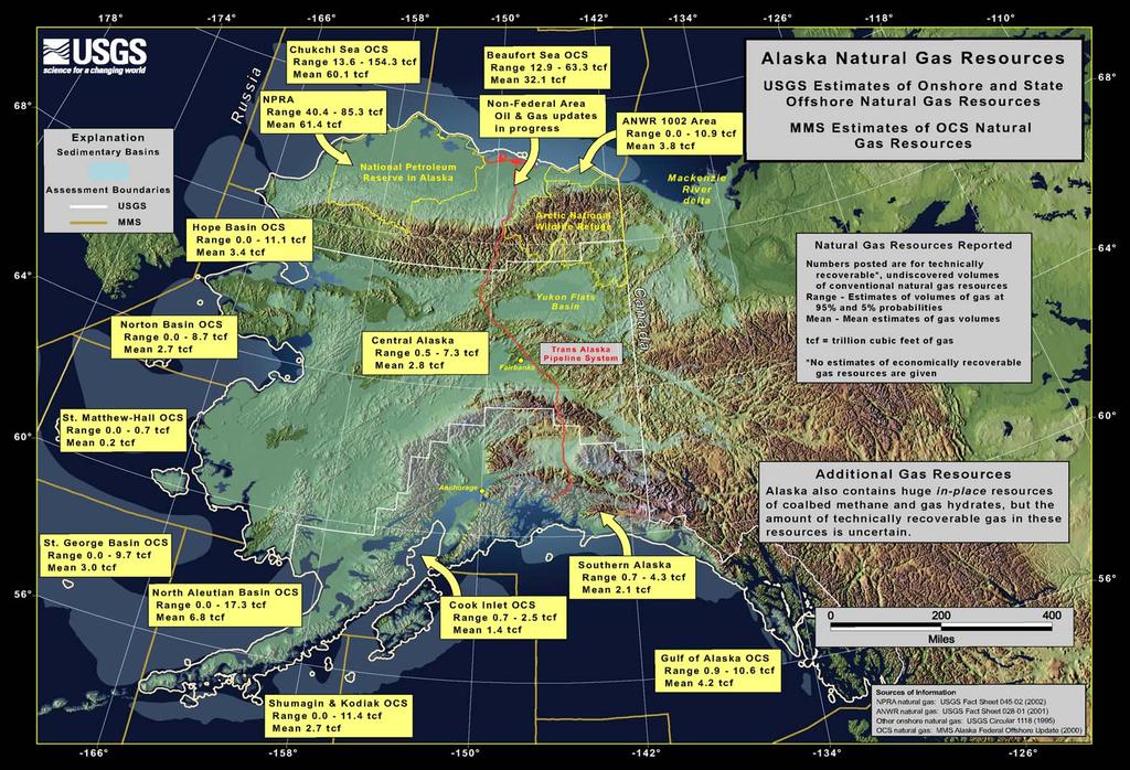
2 Sedimentary Basins of Alaska Chukchi Sea CHUKCHI Barrow Prudhoe Bay COLVILLE HOPE TAPS YUKON-KANDIK Nome SELAWIK MIDDLE TANANA Fairbanks NORTON MINCHUMINA Colorado COPPER RIVER NAVARIN HOLITNA Anchorage COOK INLET Valdez Juneau ALEUTIAN Gulf of Alaska Bering Sea NORTH ALEUTIAN KODIAK SHELF ST. GEORGE Miles

3 Working Interior Basins in Alaska I I Feel it too Jay, a strange feeling like we are going in Circles. Prudhoe Rules Cook Inlet Drools Arctic Circle Or Bust?? Kup River Kings Beluga River
4
5 Nenana & Yukon Basins Nenana Basin Holitna / Minchumina
6 Exploration Risk & Resource Assessment Wide range of values = limited data/knowledge Limited subsurface data = High Risk All interior basins are currently-- High Risk Negative data verses lack of data 9 out of 10 wells in Wildcat Frontiers are economic failures Added data/knowledge = Focus of Exploration Innovative Programs Help Mitigate Risk


7 Exploration Licensing Program Issued / Awarded Licenses Bristol Bay Nenana Basin Susitna Basin Bristol Bay License: Awarded Licensee: Bristol Shores LLC Size: 329,113 Acres Copper River Basin Nenana Basin: Issued Licensee: Andex Resources Size: 483,175 Acres Susitna Basin License 1: Issued Licensee - Forest Oil Corp. 386,207 Acres Susitna Basin License 2: Issued Licensee - Forest Oil Corp. 471,474 Acres Copper River License: Issued Licensee: Forest OilCorporation Size: 318, Acres ods/pb/pg 1/05
8 Sedimentary Basins of Alaska Barrow Prudhoe Bay Chukchi Sea CHUKCHI COLVILLE HOPE TAPS YUKON-KANDIK SELAWIK MIDDLE TANANA Fairbanks NORTON Nome MINCHUMINA Nenana Basin COPPER RIVER NAVARIN HOLITNA Anchorage COOK INLET Valdez Juneau ALEUTIAN Gulf of Alaska Bering Sea NORTH ALEUTIAN KODIAK SHELF ST. GEORGE Miles Bob Swenson Deputy Director of Research Division of Geological & Geophysical Surveys Division of Oil & Gas


9 Gas Potential Interior Area DNR-DO&G 03/05

10 Using Analogous Basins to Lower Risk Nenana Basin DNR-DO&G 11/04

11 Interior Basins Tertiary Stratigraphy Cook Inlet / Susitna/ Mat Valley Tanana / Holitna / Minchumina Yukon Flats

12 Tertiary Basin Depositional Systems Flood Plain & Channel Abd. Point Bar Channel Fill Crevasse Splay

13 Usibelli Group in Outcrop Belt South of Nenana Exploration License Area Roy D. Merritt, DGGS 08/95

14 Tertiary Reservoir Section > 25,000 Ft Recent Discoveries/ Developments
15
16 Sand Distribution in a Fluvial System
 Contour Interval = 2,000 Ft.")
17 Nenana Basin Thickness of Sedimentary Basin (Tertiary) Contour Interval = 2,000 Ft. ods 2/02
18 Nenana Basin Stratigraphic Sections SOUTH NORTH North Flank Alaska Range ARCO Totek Hills #1 Unocal Nenana #1 Deep Nenana Basin (Possible, but undrilled) Nenana Gravel Surface Eroded (Qs) (Qs) (Plio.) Eroded (Plio.) (Plio.) (M.Mio.) Lacustrine Shales (Plio.) Usibelli Group (E.Mio.) (M.Mio.) Volcanics Cantwell Fm. Sediments v v v v v v v v (Paleoc.) (Eoc.) (L. Cret.) Gravel, Sand, Silt and Clay Conglomerate and Coarse Sandstone Lacustrine / Marine Shales (Qs) (Plio.) (M.Mio.) (E.Mio.) (Eoc.) (Paleoc.) Surficial Deposits Pliocene Middle Miocene Early Miocene Eocene Paleocene vv v vvv Non-Marine Conglomerate, Sandstone, Mudstone, Coal and Minor Tuft Lacustrine / Alluvial Fan Sequence Volcanics Base of Nenana Basin?? (Paleoc.) 10,000 Ft. From C.E. Paris, 1999 (L.Cret.) Late Cretaceous Unconformity Metamorphic Basement Oblique Slip Faults? 20,000 Ft.

19 Nenana Exploration License Area with Seismic Survey Area DO&G 03/05
20 Nenana Basin Oil & Gas Potential Andex Resources, LLC, holds a 7-year Exploration License for 482,942 acres with a $2.5MM work commitment. License expires September Tertiary-age alluvial basin covering 8,500 square miles and up to > 18,000 feet deep in its northern area. Potential for coal bed methane and conventional natural gas is good. Good reservoir rocks are associated with thick coal seams. Deep source and reservoir rocks and geothermal history are conducive for formation and entrapment of conventional natural gas. Tertiary sedimentary section is time-equivalent to Cook Inlet s productive Kenai Group. Potential for oil is low due to thin low-organic source rocks. With only limited G&G data the basin is under-explored and poorly understood: Unocal Nenana #1 (1962) 3,062 deep, coal seam gas shows. ARCO Totek Hills #1 (1984) 3,590 deep, coal seam gas shows. 350 miles 2-D seismic data in southern and central basin areas ( ). Gravity coverage across entire basin. Both the overall size and different tectonic history (post depositional) limits ability to draw analogies Current exploration effort will greatly enhance our knowledge of the resource potential, and may lead to development.

21 Nenana & Yukon Basins Nenana Basin Holitna / Minchumina
22 Texa co Yukon Flats Basin Beav er Beaver Sub- Basins 5,000 YP88-4 Kaltag-Porcupine Fault Zone 5,000 10, , ,00 0 Birc h Cree k Venetie Sub- Basin 10,00 0 Texa co 5,000 Fort Yukon YP 88-3 North YP88-2 5,000 Basin Fill Thickness Seismic Survey (Exxon/Amoco) Seismic Survey (Texaco) Doyon Lands YP88-2 Tintina Fault Zone YP Miles 0' 5,000 10,000 15,000 20,000 25,000 SW Structural Traps Post Extensional Sag Post Extensional Infill Extensional Phase? Miocene Pliocene Coal Series Eocene Oligocene Fluvial Sequence Paleocene - Oligocene Lacustrine / Alluvial Fan Sequence? YP 88-2?? NE Miles Horizontal Scale Extensive, strong amplitude, high frequency reflectors Extensive, strong amplitude, low frequency reflectors From Chet Paris Local, strong amplitude, low frequency reflectors Coarse clastic wedge
23 Summary Interior Alaska sedimentary basins have clear potential for gas accumulations Currently, the available subsurface information is very limited All interior basins could be considered high risk because of this lack of data Data gathering and exploration is needed in all interior basins to characterize resource potential The Nenana Basin exploration program is critical to that effort and could discover a viable resource for providing an alternate energy source for residents of interior Alaska
Sedimentary Basins of Alaska. Bob Swenson State Geologist Alaska Division of Geological & Geophysical Surveys
 Sedimentary Basins of Alaska Bob Swenson State Geologist Alaska Division of Geological & Geophysical Surveys Colville Basin Mackenzie Alaska s Sedimentary Basins Oil & Gas Potential 200 mi. Villages /
Depositional History and Petroleum Potential of Ombilin Basin, West Sumatra - Indonesia, Based on Surface Geological Data*
 Depositional History and Petroleum Potential of Ombilin Basin, West Sumatra - Indonesia, Based on Surface Geological Data* Yahdi Zaim 1, Litto Habrianta 2, Chalid I. Abdullah 1, Aswan 1, Yan Rizal 1, Nurcahyo
Controls on clastic systems in the Angoche basin, Mozambique: tectonics, contourites and petroleum systems
 P2-2-13 Controls on clastic systems in the Angoche basin, Mozambique: tectonics, contourites and petroleum systems Eva Hollebeek, Olivia Osicki, Duplo Kornpihl Schlumberger, London, UK Introduction Offshore
EGAS. Ministry of Petroleum
 EGAS Ministry of Petroleum EGAS Ministry of Petroleum About The Block Location: N. El Arish offshore block is located in the extreme eastern part of the Egypt s economic water border and bounded from the
Block 43B - Onshore Oman
 Block 43B - Onshore Oman SUMMARY Block 43B is an 11,967 km 2 area located along the coastal area of Oman north of the Hajar Mountains. This is an unexplored region, both geographically and stratigraphically.
EGAS. Ministry of Petroleum
 EGAS Ministry of Petroleum EGAS Ministry of Petroleum About The Block Location: N. Thekah offshore block is located at about 56 km to the north of the Mediterranean shore line, 85 km to the north west
Sediment and sedimentary rocks Sediment
 Sediment and sedimentary rocks Sediment From sediments to sedimentary rocks (transportation, deposition, preservation and lithification) Types of sedimentary rocks (clastic, chemical and organic) Sedimentary
Petroleum Systems (Part One) Source, Generation, and Migration
 Source, Generation, and Migration") Petroleum Systems (Part One) Source, Generation, and Migration GEOL 4233 Class January 2008 Petroleum Systems Elements Source Rock Migration Route Reservoir Rock Seal Rock Trap Processes Generation Migration
Petroleum Systems (Part One) Source, Generation, and Migration GEOL 4233 Class January 2008 Petroleum Systems Elements Source Rock Migration Route Reservoir Rock Seal Rock Trap Processes Generation Migration
Lab 7: Sedimentary Structures
 Name: Lab 7: Sedimentary Structures Sedimentary rocks account for a negligibly small fraction of Earth s mass, yet they are commonly encountered because the processes that form them are ubiquitous in the
Blocks 31, 32, 33, 34, 35 & 36/03 Southeast Offshore Vietnam
 Blocks 31, 32, 33, 34, 35 & 36/03 Southeast Offshore Vietnam Block 31 32 33 34 35 36/03 Area (km 2) 5,036 4,440 4,630 4,700 4,630 2,950 Sea level (m) 20 20-30 30-40 50 50 50 Seismic 2D (km) 1,294 685 431
RELINQUISHMENT REPORT. License P1546 Block April 2009
 RELINQUISHMENT REPORT License P1546 Block 110-01 14 April 2009 Sherritt International Oil and Gas Limited 2000, 425-1 st street S.W., Calgary, Alberta Canada T2P 3L8 Telephone (403) 260-2900 Fax (403)
A.K. Khanna*, A.K. Verma, R.Dasgupta, & B.R.Bharali, Oil India Limited, Duliajan.
 P-92 Application of Spectral Decomposition for identification of Channel Sand Body in OIL s operational area in Upper Assam Shelf Basin, India - A Case study A.K. Khanna*, A.K. Verma, R.Dasgupta, & B.R.Bharali,
Sedimentary Cycle Best Practice: Potential Eo-Oligocene Sediments in Western Indonesia*
 Sedimentary Cycle Best Practice: Potential Eo-Oligocene Sediments in Western Indonesia* Mellinda Arisandy 1 and I Wayan Darma 1 Search and Discovery Article #11008 (2017)** Posted November 6, 2017 *Adapted
Mammoth Cave National Park, Kentucky
 Mammoth Cave National Park, Kentucky Objectives of Today s Lecture Refresher on Sedimentary Depositional Systems and Rock Classifications Transgressive and Regressive Marine Environments Carbonate Depositional
The Late Tertiary Deep-Water Siliciclastic System of the Levant Margin - An Emerging Play Offshore Israel*
 The Late Tertiary Deep-Water Siliciclastic System of the Levant Margin - An Emerging Play Offshore Israel* Michael A. Gardosh 1, Yehezkel Druckman 2 and Binyamin Buchbinder 2 Search and Discovery Article
Hydrocarbon Potential of the Marginal Fields in Niger Delta Oza Field, a case study*
 Hydrocarbon Potential of the Marginal Fields in Niger Delta Oza Field, a case study* J.N. Sahu 1, C.H.V. Satya Sai 1, V. Chintamani 1 and C. Vishnu Vardhan 1 Search and Discovery Article #20182 (2012)*
BALOCHISTAN FOLDBELT BASIN
 INTRODUCTION BALOCHISTAN FOLDBELT BASIN The Kharan-3 block is located in the Kharan Trough of Balochistan Basin. GEOLOGICAL SETTING The Balochistan Province is an Upper Cretaceous to Recent structurally
OIL INDIA LIMITED, GEOPHYSICS DEPARTMENT, DULIAJAN, ASSAM.
 J. P. Singh, M. K. Gupta & Akshaya Kumar, Oil India Limited, Duliajan. jpsingh@oilindia.in Summary Oil exploration in Upper Assam commenced with the discovery of the Digboi oilfield more than 100 years
ALASKA GEOLOGICAL SOCIETY PUBLICATIONS Stratigraphic And Structure Sections
 ALASKA GEOLOGICAL SOCIETY PUBLICATIONS 2007-2008 Stratigraphic And Structure Sections Price Western Alaska Bristol Bay Region Stratigraphic Correlation Sections (CD)... $12.00 AGS Member Price... $10.00
Vail et al., 1977b. AAPG 1977 reprinted with permission of the AAPG whose permission is required for further use.
 Well 5 Well 4 Well 3 Well 2 Well 1 Vail et al., 1977b AAPG 1977 reprinted with permission of the AAPG whose permission is required for further use. Well 5 Well 4 Well 3 Well 2 Well 1 Vail et al., 1977b
REGIONAL GEOLOGY IN KHMER BASIN
 CONTENTS 1-Khmere Basin 2-Regional Geology Khmer Basin 3-Regime Tectonic 4-Seismic Database -a/ Acquisition Data -b/ Prospect Angkor -C/ Cross Section Seismic 5-Play Type -a/ Play Schematic -b/ Structure
Integrated well log and 3-D seismic data interpretation for the Kakinada area of KG PG offshore basin
 IOSR Journal of Applied Geology and Geophysics (IOSR-JAGG) e-issn: 2321 0990, p-issn: 2321 0982.Volume 5, Issue 4 Ver. II (Jul. Aug. 2017), PP 01-05 www.iosrjournals.org Integrated well log and 3-D seismic
CONSTRUCTION MATERIALS BETWEEN THE CHUKCHI SEA AND DALTON HIGHWAY
 Working Document of the NPC Study: Arctic Potential: Realizing the Promise of U.S. Arctic Oil and Gas Resources Made Available March 27, 2015 Paper #7-17 CONSTRUCTION MATERIALS BETWEEN THE CHUKCHI SEA
ALASKA GEOLOGICAL SOCIETY PUBLICATIONS. Stratigraphic And Structure Sections
 ALASKA GEOLOGICAL SOCIETY PUBLICATIONS 2010 Stratigraphic And Structure Sections Price Western Alaska Bristol Bay Region Stratigraphic Correlation Sections (CD)...Item # WA01... $12.00 AGS Member Price...
Luderitz Basin, Offshore Namibia: Farm-out Opportunity. APPEX, London, March 2015 Graham Pritchard, Serica Energy plc
 Luderitz Basin, Offshore Namibia: Farm-out Opportunity APPEX, London, March 2015 Graham Pritchard, Serica Energy plc Serica Luderitz Basin Namibia Introduction Serica (85%, operator) 17,384 km 2 acreage
Ministry of Oil and Minerals Petroleum Exploration & Production Authority BLOCK 6 (Iryam)
") Ministry of Oil and Minerals Petroleum Exploration & Production Authority BLOCK 6 (Iryam) The Iryam Block (6) occupies an area of 3,911 km 2 in the Sabatayn Basin in the province of Shabwah in central
Ministry of Oil and Minerals Petroleum Exploration & Production Authority BLOCK 6 (Iryam) The Iryam Block (6) occupies an area of 3,911 km 2 in the Sabatayn Basin in the province of Shabwah in central
Meandering Miocene Deep Sea Channel Systems Offshore Congo, West Africa
 Meandering Miocene Deep Sea Channel Systems Offshore Congo, West Africa S. Baer* (PGS), J. E. Comstock (PGS), K. Vrålstad (PGS), R. Borsato (PGS), M. Martin (PGS), J.P. Saba (SNPC), B. Débi-Obambé (SNPC)
=%REPORT RECONNAISSANCE OF CHISHOLM LAKE PROSPECT. October 25, 1977
 =%REPORT ON FIELD RECONNAISSANCE OF CHISHOLM LAKE PROSPECT October 25, 1977 Bruce D. Vincent Imperial Oil Limited, Minerals - Coal, CALGARY, ALBERTA CHISHOLM LAKE PROSPECT Introduction The Chisholm Lake
Pre-Feasibility Report
 Pre-Feasibility Report Project Details: The Block MB-OSN-2005/1 is a Saurashtra shallow water block situated between GS-OSN- 2003/1(NELP-V) in the west, C-37/C-43 PEL in the east and Saurashtra - Dahanu
Seismic stratigraphy, some examples from Indian Ocean, interpretation of reflection data in interactive mode
 Seismic stratigraphy, some examples from Indian Ocean, interpretation of reflection data in interactive mode K. S. Krishna National Institute of Oceanography, Dona Paula, Goa-403 004. krishna@nio.org Seismic
Mackenzie Delta: Fresh Look At An Emerging Basinpart 1
 Mackenzie Delta: Fresh Look At An Emerging Basinpart 1 ABSTRACT Introduction Christopher L. Bergquist*, Peter P. Graham*, Keith R. Rawlinson and Dennis H. Johnston Devon Canada, 301 400-3rd Avenue SW,
When last we left off. Western Cordillera NA. Cretaceous. Cretaceous, continued. Cretaceous to present
 When last we left off Western Cordillera NA Cretaceous to present Wild and weird things happened in the murky past of the Archean and precambrian Cambrian through Devonian development of deep water sediments
Ministry of Oil and Minerals Petroleum Exploration & Production Authority BLOCK 85 (Al Uqlah North)
") Ministry of Oil and Minerals Petroleum Exploration & Production Authority BLOCK 85 (Al Uqlah North) The Al Uqlah North Block (85) occupies an area of 597 km 2 in the Sabatayn Basin in the province of Shabwah
Ministry of Oil and Minerals Petroleum Exploration & Production Authority BLOCK 85 (Al Uqlah North) The Al Uqlah North Block (85) occupies an area of 597 km 2 in the Sabatayn Basin in the province of Shabwah
Figure 1: Location and bathymetry of the study area. Gulf of Guinea. Cameroon. Congo. Gabon. PGS/DGH Gabon MegaSurvey Coverage (35000Km 2 ) Eq.
 Eq.") Deepwater hydrocarbon prospectivity analysis of offshore North and South Gabon Muhammad S Tamannai (*), Thomas Hansen (1), Ron Borsato (1), Jennifer Greenhalgh (1) Martial-Rufin Moussavou (2) & Landry
Deepwater hydrocarbon prospectivity analysis of offshore North and South Gabon Muhammad S Tamannai (*), Thomas Hansen (1), Ron Borsato (1), Jennifer Greenhalgh (1) Martial-Rufin Moussavou (2) & Landry
Geologic Trips San Francisco and the Bay Area
 Excerpt from Geologic Trips San Francisco and the Bay Area by Ted Konigsmark ISBN 0-9661316-4-9 GeoPress All rights reserved. No part of this book may be reproduced without written permission in writing,
The Kingfisher Field, Uganda - A Bird in the Hand! S R Curd, R Downie, P C Logan, P Holley Heritage Oil plc *
 A Bird in the Hand! EXTENDED ABSTRACT The Kingfisher Field, Uganda - A Bird in the Hand! Heritage Oil plc * The Kingfisher Field lies on Uganda s western border beneath Lake Albert, situated in the western
Abstract. Introduction. Regional Setting. GCSSEPM to be published December 2003
 Shelf Margin Deltas and Associated Deepwater Deposits: Implications on Reservoir Distribution and Hydrocarbon Entrapment, Block VI-1, Ulleung Basin, East Sea, South Korea Sneider, John S. Sneider Exploration,
Bulletin of Earth Sciences of Thailand
 Quantitative Seismic Geomorphology of Early Miocene to Pleistocene Fluvial System of Northern Songkhla Basin, Gulf of Thailand Oanh Thi Tran Petroleum Geoscience Program, Department of Geology, Faculty
Relinquishment Report. Licence P2016 Block 205/4c
 Relinquishment Report Licence P2016 Block 205/4c September 2016 JX Nippon Exploration and Production (U.K.) Limited Idemitsu Petroleum UK Ltd. Table of Contents 1. Licence Information... 1 2. Licence Synopsis...
MUHAMMAD S TAMANNAI, DOUGLAS WINSTONE, IAN DEIGHTON & PETER CONN, TGS Nopec Geological Products and Services, London, United Kingdom
 Geological and Geophysical Evaluation of Offshore Morondava Frontier Basin based on Satellite Gravity, Well and regional 2D Seismic Data Interpretation MUHAMMAD S TAMANNAI, DOUGLAS WINSTONE, IAN DEIGHTON
1.1 INTRODUCTION TO THE PROJECT:
 .Chapter 1: Introduction 1.1 INTRODUCTION TO THE PROJECT: Stratigraphic correlation in Ransi Member in the Tatau-Bintulu area of Sarawak, East Malaysia has always been difficult, due to the lack of large
Play fairway mapping in the Northeast Atlantic Margin Comparison between mature and immature basins. David Mudge, Joanne Cranswick
 Play fairway mapping in the Northeast Atlantic Margin Comparison between mature and immature basins David Mudge, Joanne Cranswick Contents Ternan North Sea Play fairway mapping Tertiary case study Northeast
APPENDIX C GEOLOGICAL CHANCE OF SUCCESS RYDER SCOTT COMPANY PETROLEUM CONSULTANTS
 APPENDIX C GEOLOGICAL CHANCE OF SUCCESS Page 2 The Geological Chance of Success is intended to evaluate the probability that a functioning petroleum system is in place for each prospective reservoir. The
Blocks offered in Sri Lanka s Second Licensing Round
 Blocks offered in Sri Lanka s Second Licensing Round Sri Lankan Main Basins Cauvery Basin Cauvery Deep Water sub-basin Mannar Basin 2 Structural Framework Sri Lanka Basins Cauvery & Mannar Basins were
DATA REPOSITORY MATERIAL: PALEOCHANNEL GROUP MAPPING DESCRIPTIONS
 Data Repository item 2695 DATA REPOSITORY MATERIAL: PALEOCHANNEL GROUP MAPPING DESCRIPTIONS Groups 1 (North Myrtle Beach) and 2 (Atlantic Beach) Channel Groups 1 (North Myrtle Beach) and 2 (Atlantic Beach)
Stratigraphic Plays in Active Margin Basin: Fluvio-Deltaic Reservoir Distribution in Ciputat Half Graben, Northwest Java Basin*
 Stratigraphic Plays in Active Margin Basin: Fluvio-Deltaic Reservoir Distribution in Ciputat Half Graben, Northwest Java Basin* Ary Wahyu Wibowo 1, Astri Pujianto 1, Wisnu Hindadari 1, Arief Wahidin Soedjono
Sequence Stratigraphy. Historical Perspective
 Sequence Stratigraphy Historical Perspective Sequence Stratigraphy Sequence Stratigraphy is the subdivision of sedimentary basin fills into genetic packages bounded by unconformities and their correlative
Reconstruction of Paleogeographic Setup of Tura Formation in Rudrasagar-Disangmukh-Panidihing Area of Upper Assam Shelf using 3-D Seismic techniques
 5th Conference & Exposition on Petroleum Geophysics, Hyderabad-2004, India PP 792-796 in Rudrasagar-Disangmukh-Panidihing Area of Upper Assam Shelf using 3-D Seismic techniques S.M.Ismail 1, R.N.Dwivedi
Revised reservoir model for the Paleocene mounds of the Utsira High, North Sea, Norway John Wild (1) & Nowell Briedis (2)
 & Nowell Briedis (2)") Revised reservoir model for the Paleocene mounds of the Utsira High, North Sea, Norway John Wild (1) & Nowell Briedis (2) (1) Mobil North Sea LLC (2) Esso Exploration & Production Norway A/S (ExxonMobil
Revised reservoir model for the Paleocene mounds of the Utsira High, North Sea, Norway John Wild (1) & Nowell Briedis (2) (1) Mobil North Sea LLC (2) Esso Exploration & Production Norway A/S (ExxonMobil
Appendix 7: Comparison of Queen Charlotte Basin Petroleum Situation with Other Offshore Basins 5
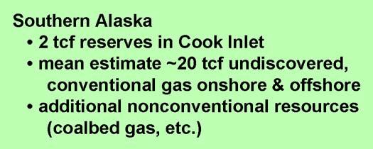
 Appendix 7: Comparison of Queen Charlotte Basin Petroleum Situation with Other Offshore Basins 5 1. COOK INLET (ALASKA) The following information is extracted and reworked in part from Magoon, (1994) and
Sequence Stratigraphy of the Upper Cretaceous Niobrara Formation, A Bench, Wattenberg Field, Denver Julesburg Basin, Colorado*
 Sequence Stratigraphy of the Upper Cretaceous Niobrara Formation, A Bench, Wattenberg Field, Denver Julesburg Basin, Colorado* Lisa E. Remington LaChance 1 and Mark C. Robinson 1 Search and Discovery Article
Education Days Moscow Closing Session
 Education Days Moscow 2013 Basin and Petroleum Systems Modelling: Applications for Conventional and Unconventional Petroleum Exploration Risk and Resource Assessments By Dr Bjorn Wygrala Schlumberger 21-22
Search and Discovery Article #20097 (2011) Posted January 31, 2011
 Posted January 31, 2011") Integrated Geological and Engineering Studies in Support of Producing Light Oil from a Frozen Reservoir: A Case Study from Umiat Oil Field, Northern Alaska* C. Hanks 1, J. Mongrain 2, A. Dandekar 2, P.
Integrated Geological and Engineering Studies in Support of Producing Light Oil from a Frozen Reservoir: A Case Study from Umiat Oil Field, Northern Alaska* C. Hanks 1, J. Mongrain 2, A. Dandekar 2, P.
GEOLOGY MEDIA SUITE Chapter 5
 UNDERSTANDING EARTH, SIXTH EDITION GROTZINGER JORDAN GEOLOGY MEDIA SUITE Chapter 5 Sedimentation Rocks Formed by Surface Processes 2010 W.H. Freeman and Company Mineralogy of sandstones Key Figure 5.12
Alaska Resource Overview
 Alaska Resource Overview Kennicott Mine JOGMEC Presentation Tokyo, Japan November 7, 2006 Tom Crafford, Mining Coordinator tom_crafford@dnr.state.ak.us Alaska Department of Natural Resources Office of
Subsurface Geology and Resource Exploration
 LAB 11. Subsurface Geology and Resource Exploration Locating earth resources such as aluminum, copper, gold and gemstones has been an important job for geologists for a long time. This lab deals with the
Facies Distribution and Impact on Petroleum Migration in the Canterbury Basin, New Zealand
 Facies Distribution and Impact on Petroleum Migration in the Canterbury Basin, New Zealand Tusar R. Sahoo 1, Karsten F. Kroeger 1, Glenn Thrasher 1, Stuart Munday 2, Hugh Mingard 3, Nick Cozens 2 and Matthew
Understanding Earth Fifth Edition
 Understanding Earth Fifth Edition Grotzinger Jordan Press Siever Chapter 5: SEDIMENTATION: Rocks Formed by Surface Processes Lecturer: H Mohammadzadeh Assistant professors, Department of Geology, FUM Copyright
Case Study of the Structural and Depositional-Evolution Interpretation from Seismic Data*
 Case Study of the Structural and Depositional-Evolution Interpretation from Seismic Data* Yun Ling 1, Xiangyu Guo 1, Jixiang Lin 1, and Desheng Sun 1 Search and Discovery Article #20143 (2012) Posted April
Orphan Basin, Offshore Newfoundland: New seismic data and hydrocarbon plays for a dormant Frontier Basin
 Orphan Basin, Offshore Newfoundland: New seismic data and hydrocarbon plays for a dormant Frontier Basin Jerry Smee* G&G Exploration Consulting, 301 400-3rd Avenue SW, Calgary, AB, T2P 4H2 Sam Nader, Paul
Hydrocarbon Systems, Basin Analyses, Field & Subsurface Data: Bristol Bay - Alaska Peninsula Frontier Basin
 Hydrocarbon Systems, Basin Analyses, 2004-2007 Field & Subsurface Data: Bristol Bay - Alaska Peninsula Frontier Basin Rocky Reifenstuhl AKDGGS Paul Decker * & Ken Helmold * Bob Gillis & Andrea Loveland
Lecture Outline Wednesday - Friday February 14-16, 2018
 Lecture Outline Wednesday - Friday February 14-16, 2018 Quiz 2 scheduled for Friday Feb 23 (Interlude B, Chapters 6,7) Questions? Chapter 6 Pages of the Past: Sedimentary Rocks Key Points for today Be
(Brown & Loucks, 2009)
") SECARB Phase 3, Task 15 Geological CO 2 Sequestration Capacity Estimate Offshore Northern Gulf of Mexico March 9, 2011 Prepared by David L. Carr Project Team: Cari Breton, GIS Analyst David L. Carr, Reservoir
SECARB Phase 3, Task 15 Geological CO 2 Sequestration Capacity Estimate Offshore Northern Gulf of Mexico March 9, 2011 Prepared by David L. Carr Project Team: Cari Breton, GIS Analyst David L. Carr, Reservoir
Chapter 3. Geology & Tectonics
 Chapter 3 Geology & Tectonics 3.1 Geology The general geological features of Indonesia are shown in Figure 3.1. The basement formation is metamorphic and it is intruded with plutonic formations. They are
Results. 1. Table I - Estimated Speculative Recoverable Resources of Oil and Hatural Gas in Alaska *.* Page TABLE OF CONTENTS
 STATE OF ALASKA DEPAR- OF NATURAL RESOURCES DIVISION OF GEOLOGICAL AND GEOPHYSICAL SURVEYS ESTIMATED SPECULATIVE RECOVERABLE RESOURCES. OF OIL AM) NATURAL GAS IN ALASKA Robert M. Klein, William M. Lyle,
11/22/2010. Groundwater in Unconsolidated Deposits. Alluvial (fluvial) deposits. - consist of gravel, sand, silt and clay
 deposits. - consist of gravel, sand, silt and clay") Groundwater in Unconsolidated Deposits Alluvial (fluvial) deposits - consist of gravel, sand, silt and clay - laid down by physical processes in rivers and flood plains - major sources for water supplies
Groundwater in Unconsolidated Deposits Alluvial (fluvial) deposits - consist of gravel, sand, silt and clay - laid down by physical processes in rivers and flood plains - major sources for water supplies
Buried-valley Aquifers: Delineation and Characterization from Reflection Seismic and Core Data at Caledon East, Ontario
 Buried-valley Aquifers: Delineation and Characterization from Reflection Seismic and Core Data at Caledon East, Ontario Russell, H.A.J. 1, S.E. Pullan 1, J.A. Hunter 1, D.R. Sharpe 1, and S. Holysh 2 1
The Stratigraphic Trap in the Benchamas Field Pattani Basin, Gulf of Thailand
 The Stratigraphic Trap in the Benchamas Field Pattani Basin, Gulf of Thailand Jurairat Buangam Petroleum Geoscience Program, Department of Geology, Faculty of Science, Chulalongkorn University, Bangkok
RWE Dea UK SNS Limited (50%), Faroe Petroleum (UK) Limited
, Faroe Petroleum (UK) Limited") 1. Licence information Licence Number P1975 Licence Round 27 th (2012) Licence Type Traditional Blocks 3/28c & 9/3e Licensees Work Programme 2. Synopsis RWE Dea UK SNS Limited (50%), Faroe Petroleum (UK)
1. Licence information Licence Number P1975 Licence Round 27 th (2012) Licence Type Traditional Blocks 3/28c & 9/3e Licensees Work Programme 2. Synopsis RWE Dea UK SNS Limited (50%), Faroe Petroleum (UK)
Hydrocarbon Exploration of Mesozoic in Kutch Offshore Area
 6 th International Conference & Exposition on Petroleum Geophysics Kolkata 2006 Hydrocarbon Exploration of Mesozoic in Kutch Offshore Area Ram Krishna Singh 1, R.C. Agrawalla 2, D. P. Verma 3, A. K. Goel
Clastic Sedimentary Rocks
 Clastic Sedimentary Rocks Alessandro Grippo, Ph.D. Alternating sandstones and mudstones in Miocene turbidites Camaggiore di Firenzuola, Firenze, Italy Alessandro Grippo review Mechanical weathering creates
Structural Geology Lab. The Objectives are to gain experience
 Geology 2 Structural Geology Lab The Objectives are to gain experience 1. Drawing cross sections from information given on geologic maps. 2. Recognizing folds and naming their parts on stereoscopic air
General Geologic Setting and Seismicity of the FHWA Project Site in the New Madrid Seismic Zone
 General Geologic Setting and Seismicity of the FHWA Project Site in the New Madrid Seismic Zone David Hoffman University of Missouri Rolla Natural Hazards Mitigation Institute Civil, Architectural & Environmental
Perspectives from Offshore Argentina & Uruguay
 Perspectives from Offshore Argentina & Uruguay A Prospectivity Overview Hannah Kearns October 2018 Introduction Argentina Offshore License Round 1 14 blocks Argentina North, 24 Austral-Malvinas Offshore
Horizontal Well Injector/Producer Pair Platong Field, Pattani Basin, Thailand*
 Horizontal Well Injector/Producer Pair Platong Field, Pattani Basin, Thailand* Abhiphat Pakdeesirote 1, Sonchawan Ackagosol 3, Sarayoot Geena 3, Nualjun Kitvarayut 3, Kenneth Lewis 2, Tom Tran 3, Nancy
Regional Paleogeography and Implications for Petroleum Prospectivity, Taranaki Basin, New Zealand*
 Regional Paleogeography and Implications for Petroleum Prospectivity, Taranaki Basin, New Zealand* Dominic P. Strogen 1, Kyle J. Bland 1, Jan R. Baur 1,2, and Peter R. King 1 Search and Discovery Article
Objectives: Define Relative Age, Absolute Age
 S6E5. Students will investigate the scientific view of how the earth s surface is formed. c. Classify rocks by their process of formation. g. Describe how fossils show evidence of the changing surface
Soils, Hydrogeology, and Aquifer Properties. Philip B. Bedient 2006 Rice University
 Soils, Hydrogeology, and Aquifer Properties Philip B. Bedient 2006 Rice University Charbeneau, 2000. Basin Hydrologic Cycle Global Water Supply Distribution 3% of earth s water is fresh - 97% oceans 1%
Coalbed Methane: Louisiana s Unexplored Energy Resource
 BRI Bulletin 1 Coalbed Methane: Louisiana s Unexplored Energy Resource John B. Echols 1 Abstract The Central Louisiana Coalbed Methane Basin (CELCOM) is part of a much larger coalbed methane basin, the
History of geology and research of the Jan Mayen Micro-Continent and its associated exploration risks.
 History of geology and research of the Jan Mayen Micro-Continent and its associated exploration risks. Anett Blischke, Iceland GeoSurvey Þórarinn S. Arnarson, Karl Gunnarsson, Iceland GeoSurvey The North-Dreki
Stratigraphic Trap Identification Based on Restoration of Paleogeophology and Further Division of System Tract: A Case Study in Qingshui Subsag*
 Stratigraphic Trap Identification Based on Restoration of Paleogeophology and Further Division of System Tract: A Case Study in Qingshui Subsag* Cao Laisheng 1, Yu Lin 1, Liu Jianlun 1, Xiang Sheng 1,
SEDIMENTARY BASINSS S CANADA NORTH OF 60
 AAPG 2005 ANNUAL CONVENTION EXPLORING ENERGY SYSTEMS JUNE 20, 2005 - CALGARY, ALBERTA Updated to December 31, 2007 Canada's Discovered Oil and Gas Resources North of 60 Kenneth J. Drummond SEDIMENTARY
RWE Dea UK SNS Limited (50%, operator) Dana Petroleum (E&P) Limited (50%)
 Dana Petroleum (E&P) Limited (50%)") 1. Licence Information Licence Number P1726 Licence Round 25 th (2008) Licence Type Traditional Blocks 43/17a & 43/18a Licensees Work Programme RWE Dea UK SNS Limited (50%, operator) Dana Petroleum (E&P)
1. Licence Information Licence Number P1726 Licence Round 25 th (2008) Licence Type Traditional Blocks 43/17a & 43/18a Licensees Work Programme RWE Dea UK SNS Limited (50%, operator) Dana Petroleum (E&P)
ANGOLA OFFSHORE LICENSING 2007 BLOCK 46
 AGOLA OFFHOR LICIG 2007 BLOCK 46 DATA BA AVAILABILITY Figure 1 shows the seismic data available on Block 46. Fig. 1 Commercial 2D surveys: esterngeco: 794 km. GX Technology: 116 km. Commercial 3D surveys:
Sediment. Weathering: mechanical and chemical decomposition and disintegration of rock and minerals at the surface
 Sediment Some basic terminology Weathering: mechanical and chemical decomposition and disintegration of rock and minerals at the surface Erosion: removal of weathered rock and minerals from one place to
Shallow Gas Prospect Evaluation in Shahbazpur Structure Using Seismic Attributes Analysis - a Case Study for Bhola Island, Southern Bangladesh
 Dhaka Univ. J. Sci. 64(2): 135-140, 2016 (July) Shallow Gas Prospect Evaluation in Shahbazpur Structure Using Seismic Attributes Analysis - a Case Study for Bhola Island, Southern Bangladesh Morshedur
Sedimentary System Characteristics of Deng-3 Section on Paleo-central. Uplift Belt in Northern Songliao Basin. Siyang Li1,a*
 Sedimentary System Characteristics of Deng-3 Section on Paleo-central Uplift Belt in Northern Songliao Basin Siyang Li1,a* 1 School of Earth Sciences and Resources, China University of Geosciences, Beijing,
Key Elements of the Petroleum Systems of the Rockall and Slyne-Erris Basins
 Key Elements of the Petroleum Systems of the Rockall and Slyne-Erris Basins Bandon Corrib Dooish Atlantic Ireland Conference, Dublin, 1 st - 2 nd November 2016 Rockall and Slyne-Erris Basins Only 11 exploration
Overview of Selected Shale Plays in New Mexico*
 Overview of Selected Shale Plays in New Mexico* Ron Broadhead 1 Search and Discovery Article #10627 (2014)** Posted August 18, 2014 *Adapted from presentation at RMAG luncheon meeting, Denver, Colorado,
Petroleum Geology and Exploration History of the Mergui Basin, THAILAND EPPM (P1) PROJECT
 PROJECT") Petroleum Geology and Exploration History of the Mergui Basin, THAILAND EPPM (P1) PROJECT KRABI, THAILAND 12 th May 2009 Contents of Presentation 1. Exploration History 1. Exploration History 2. General
Petroleum Geology and Exploration History of the Mergui Basin, THAILAND EPPM (P1) PROJECT KRABI, THAILAND 12 th May 2009 Contents of Presentation 1. Exploration History 1. Exploration History 2. General
Ministry of Oil and Minerals Petroleum Exploration & Production Authority BLOCK 80 (WADI SARR)
") Ministry of Oil and Minerals Petroleum Exploration & Production Authority BLOCK 80 (WADI SARR) The Wadi Sarr Block (80) occupies an area of 1961 km 2 on the Sayun- Masilah Basin in the central Yemen. Block
Ministry of Oil and Minerals Petroleum Exploration & Production Authority BLOCK 80 (WADI SARR) The Wadi Sarr Block (80) occupies an area of 1961 km 2 on the Sayun- Masilah Basin in the central Yemen. Block
Licence P.185, Blocks 30/11b and 30/12b Relinquishment Report February 2015
 1. General Licence: P.185 Round: 4 th (1972) Licence Type: Traditional Blocks: 30/11b (part) and 30/12b (part) Equity: Talisman Sinopec Energy UK Limited 60%, Centrica North Sea Oil Limited 40% Work Programme:
The United States & Canada. A Regional Study of Anglo America
 A Regional Study of Anglo America Landform Regions of the United States & Canada world leaders in agricultural and industrial production because of... VAST LANDS stretch from the Atlantic Ocean on the
The Ocean Floor Earth Science, 13e Chapter 13
 The Ocean Floor Earth Science, 13e Chapter 13 Stanley C. Hatfield Southwestern Illinois College The vast world ocean Earth is often referred to as the blue planet Seventy-one percent of Earth s surface
Alaska Oil Discoveries
 Identifying new prospects in Alaska's North Slope trends. Chris Williams, MS., PG. Geoscience Advisor Stratigraphic Column Era M.Y.A. Albian ~113 Formation Oil and Gas Producing Areas Kuvlum, Hammerhead.
RELINQUISHMENT REPORT FOR LICENCE P.1663, BLOCK 29/4b and 29/5e
 RELINQUISHMENT REPORT FOR LICENCE P.1663, BLOCK 29/4b and 29/5e Licence: P.1663 Blocks: 29/4b & 29/5e 25th Round Traditional Licence Operator: Ithaca Energy UK(Ltd) 100% Work Programme Summary The agreed
Chapter 5. The Sedimentary Archives
 Chapter 5 The Sedimentary Archives Factors affecting Sedimentary Characteristics 1. Tectonic setting 2. Physical, chemical, and biological processes in the depositional environment 3. Method of sediment
Salt Geology and New Plays in Deep-Water Gulf of Mexico* By Abu Chowdhury 1 and Laura Borton 1
 Salt Geology and New Plays in Deep-Water Gulf of Mexico* By Abu Chowdhury 1 and Laura Borton 1 Search and Discovery Article #10131 (2007) Posted August 25, 2007 *Adapted from extended abstract prepared
A Sedimentary Rock is..
 Sedimentary Rocks A Sedimentary Rock is.. rock formed from the lithification or crystallization of: 1. Minerals in solution 2. Organic remains 3. Materials produced by living things (biochemical) 4. Clastic
PLATEAU UPLIFT, EPEIROGENEY AND CLIMATE CHANGES The KALAHARI PLATEAU, a world class laboratory
 PLATEAU UPLIFT, EPEIROGENEY AND CLIMATE CHANGES The KALAHARI PLATEAU, a world class laboratory F. Guillocheau M. De Wit G. Dubois B. Linol F. Eckardt W. Cotterill D. Rouby C. Robin Géosciences-Rennes Université