Regional Paleogeography and Implications for Petroleum Prospectivity, Taranaki Basin, New Zealand*
|
|
|
- Naomi Stevenson
- 6 years ago
- Views:
Transcription
1 Regional Paleogeography and Implications for Petroleum Prospectivity, Taranaki Basin, New Zealand* Dominic P. Strogen 1, Kyle J. Bland 1, Jan R. Baur 1,2, and Peter R. King 1 Search and Discovery Article #10432 (2012)** Posted July 30, 2012 *Adapted from oral presentation at AAPG Annual Convention and Exhibition, Long Beach, California, USA, April 22-25, 2012 **AAPG 2012 Serial rights given by author. For all other rights contact author directly. 1, Lower Hutt, New Zealand (d.strogen@gns.cri.nz) 2 Current address, Total Exploration, Pau, France Abstract The Taranaki Basin, located predominantly offshore of western North Island, is currently the only sedimentary basin in New Zealand with active hydrocarbon production. The basin has had a complex history from the Late Cretaceous through to the Neogene, encompassing rifting, passive subsidence, compressional tectonics related to the evolution of the Australia-Pacific plate boundary, and late back-arc rift phases. As part of ongoing research into New Zealand s petroleum resources, a regional reassessment of the paleogeographic evolution of the Taranaki Basin and surrounding areas has been undertaken, the results of which are presented here. This forms part of a larger project investigating the Taranaki Basin through new basinwide seismic mapping, biostratigraphy, facies analysis, and basin modelling. A set of 32 maps spanning the Late Cretaceous to present day have been produced, which synthesise paleobathymetric and paleofacies data. These maps expand, both in number and geographical area, on those from previous studies and incorporate significant new data. Inputs include map data from previous studies, a new compilation of biostratigraphic and bathymetric data from >200 wells in and around the Taranaki Basin and compilation of outcrop data from areas surrounding the basin. Perhaps the most important addition in this study is the use of seismic attribute and facies mapping, leading to better delineation of depositional elements, both in areas covered by 3D data and in sparser regional 2D surveys. The study was carried out using GIS, allowing for the capture of significant metadata relating to features such as wells, faults, paleofacies and paleobathymetry. The maps were chosen to provide at least one paleogeographic reconstruction for major sequences bounded by regionally mapped seismic reflectors. Where possible, additional maps were constructed to capture major changes in facies or paleobathymetry within sequences.
2 These new paleogeographic maps provide improved control on crucial elements of the petroleum system, particularly on the distribution of potential reservoir facies, such as Cretaceous-Paleogene marginal- to shallow-marine facies and Miocene-Pliocene submarine fan systems. These maps capture the most important aspects of the tectonic and sedimentary evolution of the Taranaki Basin and form the basis for ongoing more detailed paleofacies mapping, basin modelling studies, and evaluation of regional petroleum exploration play concepts. References King, P.R., and G.P. Trasher, 1996, Paleogeographic maps of Taranaki Basin: Geological Society of New Zealand Miscellaneous Publication, v. 91A, 102 p. Vonk, A.J., and P.J.J. Kamp, 2008, The late Miocene southern and central Taranaki inversion phase (SCTIP) and related sequence stratigraphy and paleogeography: New Zealand Petroleum Conference: Beyond 2008, 17 p.


3 Regional paleogeography and implications for petroleum prospectivity, Taranaki Basin, New Zealand 1 Dominic P. Strogen 1, Kyle J. Bland 1, Jan R. Baur 1,2 and Peter R. King 1 1, Lower Hutt, New Zealand 2 present address: Total Exploration, Pau, France

4 Overview of talk 2 Introduction to regional New Zealand tectonic setting Methods and data sources for paleogeographic map production Paleogeographic maps and comments on petroleum system Discussion and conclusions


5 Regional setting of New Zealand within the SW Pacific 3 Hawaiian Is. Papua New Guinea Australia Pacific Ocean Tasman Sea New Zealand Antarctica Source: DK World Atlas Millennium Edition


6 Regional setting of Taranaki Basin within Zealandia 4

7 Tectonic setting of the Taranaki Basin 5 Diagram courtesy of A.J. Vonk Currently located close to plate boundary, but this only formed c. 23 Ma
 spanning the Late Cretaceous to present day.")


8 Aims of this study This study forms part of the 4D Taranaki Project and aims to produce a suite of maps (32 in total) spanning the Late Cretaceous to present day. Maps cover the Taranaki Basin and adjacent areas, with at least one paleogeographic reconstruction for each major sequence bounded by mapped seismic reflectors. 6 4D Taranaki Project: Remapping the Taranaki Basin using calibrated well and seismic data, to provide a new generation of subsurface structure and depositional systems maps, as a framework for developing 3D and 4D models of basin evolution and petroleum systems.

9 Example regional seismic transect of the Taranaki Basin 7

10 Generalised stratigraphy of the Taranaki Basin 8
 both lithology and extensive biostratigraphic and paleobathymetric database.")
11 Inputs to paleogeographic mapping 9 Compilation of existing paleogeographic interpretations. New compilation of well data (212 wells) both lithology and extensive biostratigraphic and paleobathymetric database. Information from outcrops, both literature and new 1:250k geological mapping in surrounding onshore areas. New facies data from seismic attribute mapping. Detailed reservoir studies of selected intervals. Data compiled in ArcGIS.


 35 3-D seismic")
12 Open file data 10 This project is possible due to the existence of a very large open file dataset available for the Taranaki Basin: >200 wells Large 2-D seismic dataset (grey; ~21000 km) 35 3-D seismic surveys (~6000 km 2 )

13 Biostratigraphy and paleobathymetry 11


.")

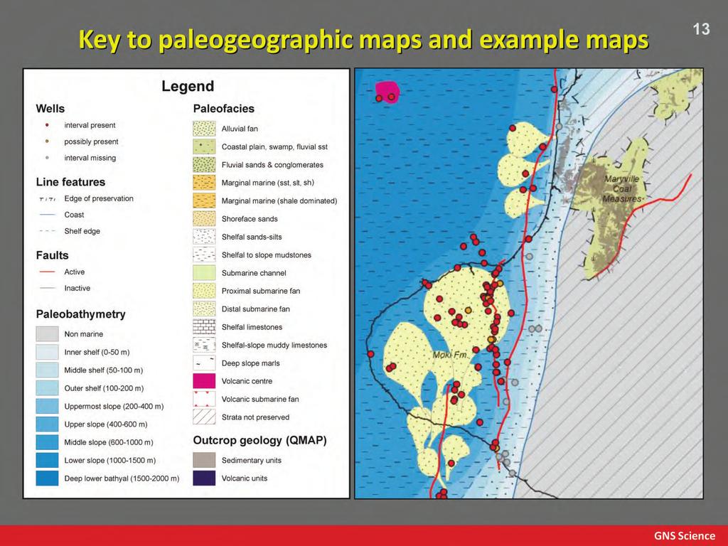
14 New inputs: seismic attribute mapping 12 Seismic stratigraphic and attribute mapping (Jan Baur Ph.D.) has been used to constrain paleofacies interpretations. Pre-existing paleogeographic maps were based solely on well data. Left: Two late Miocene examples shown (after King and Thrasher, 1996; and Vonk et al., 2008). Seismic attribute mapping improves upon existing maps by delineating depositional features, with the shelf edge, slope feeder channels and basin-floor fans well imaged.
15
 14 Dominated by nonmarine deposition, with a link to marine deepwater Taranaki")
 sandstones form a potential reservoir,")
16 Late Cretaceous (c. 75 Ma, Campanian) 14 Dominated by nonmarine deposition, with a link to marine deepwater Taranaki and Reinga basins. Deposition in active faultcontrolled sub-basins. Absent on many highs Fluvial (to deltaic in the NW) sandstones form a potential reservoir, although no current discoveries at this level. Coals of this age (Rakopi Fm) form an important source rock unit.
 Dominated by shallow marine deposition")


17 latest Cretaceous (c. 66 Ma, late Maastrichtian) Dominated by shallow marine deposition during latest Cretaceous marine transgression. Deposition in active faultcontrolled sub-basins. Absent on some highs, but onlapped further than at 75 Ma. Although no production from this level, sandstone facies (North Cape Fm) have good reservoir potential. Coals in marginal areas also have source potential. 15
 16 Nonmarine through to shoreface system at head of")


18 Mid-Late Paleocene (c. 60 Ma, Selandian ) 16 Nonmarine through to shoreface system at head of embayment. Typical of Paleocene-Eocene. Paleocene active fault-controlled sub-basins in south. Passive subsidence underway elsewhere. Highs fully onlapped. Good reservoir potential, with production in the Tui, Maui and Kupe fields. Proximal coaly facies have source potential. Some development of Late Paleocene marine source rocks in distal areas (Waipawa facies).


19 Late Eocene (c. 35 Ma, Priabonian) 17 Transgressed coastal plain through to shoreface system. Widespread nonmarine deposition in southern sub-basins and Waikato in NE. Some extensional faulting in S (related to Emerald Basin rifting?). Compression to the north in the Reinga Basin. Shoreface sandstones (McKee Fm) form reservoir in onshore fields. Deep marine fan sandstones (Tangaroa Fm) form good potential reservoirs in N (with shows).
 Onset of reverse movement on major faults, with formation of foredeep.")
 have good")
20 early Late Oligocene (c. 27 Ma, early Chattian ) Onset of reverse movement on major faults, with formation of foredeep. Slope muds with local sandy fans. Condensed calcareous ooze in distal NW. Gradual transgression of highs away from faults, by shelfal deposits Fans (Tariki Sst Mbr) have good reservoir potential with production in onshore fields (TAWN, McKee). Distal Otaraoa/Tikorangi fms form good seals. 18
 Maximum flooding, transgression of")
 Deposition dominated by carbonate facies.")

21 latest Oligoceneearliest Miocene (c. 24 Ma, l Chattian-e Aquitanian ) Maximum flooding, transgression of most of study area (and also possibly of much of Zealandia?) Deposition dominated by carbonate facies. Full extent of transgression to E of TFS is unclear, as is the extent of surviving highs. Resedimented carbonates (Tikorangi Fm) form reservoirs in onshore fields. Distal facies forms good seal across much of basin. 19
 Slope to basinal")


22 Middle Miocene (c. 14 Ma, Langhian-Serravillian) Slope to basinal muds with development of basin-floor fans. Significant inversion in SW and start of progradation of shelf and shoreline to N. Volcanism in north. Moki Fm fans have good reservoir potential (Maari, Ngatoro, Kaimiro fields). 20
 Slope-shelf system rapidly prograding out")


23 early Late Miocene (c. 10 Ma, early Tortonian) Slope-shelf system rapidly prograding out into deep basin. Change from N to NW sediment transport. Mudstone dominated, but with basin-floor fans and slope channel systems. Mount Messenger Formation fans and Urenui Fm slope channels systems form good reservoirs in numerous onshore fields. Volcaniclastic fans (Mohakatino Fm) also have reservoir potential. 21
 22 Major subsidence in E (Wanganui")


24 Early Pliocene (c. 4 Ma, late Zanclean) 22 Major subsidence in E (Wanganui Basin) and Northern Graben. Deposition of slope-basinal muds with submarine fans. Condensed marls in NW. Southward jump and spread in active extension in Northern and Central grabens and die-off in volcanism. Mangaa Fm fans form good potential reservoirs (e.g., Karewa Field).


25 Discussion 23 Taranaki Basin has a complex history with Cretaceous (to Paleocene) rifting and a transition to passive thermal subsidence in the Paleogene. Inversion from the Oligocene, more severe in Neogene. Restricted to eastern areas, more proximal to plate boundary. Complex interaction of extension, and associated volcanism, in N, and compression in S through Neogene. The transition from extension to compression has moved south through time. Cretaceous-Paleogene nonmarine to shallow marine strata form good potential reservoirs, with associated coals providing the majority of potential source rocks. Oligocene-Neogene fans/slope channel systems also provide well tested reservoirs.

26 Conclusions 24 A new suite of regional paleogeographic maps (32) has been produced for the Taranaki Basin and surrounding areas, spanning the Late Cretaceous to present. These greatly expand in area and detail on the previous set of regional maps and incorporate large quantities of new well and outcrop data. For the first time, these maps incorporate seismic-attribute mapping, allowing more accurate delineation of facies. This is especially important in areas with limited well control. These maps allow better prediction of important aspects of the petroleum system, such as the distribution of source and reservoir facies and should improve analysis of potential plays.


27 Thank you! 25 For more information on New Zealand geology see the GNS website: and the in particular the Petroleum Basin Explorer website: Acknowledgement: this project forms part of the Petroleum Basin Research programme, funded by direct core funding to GNS from the New Zealand Government.
Facies Distribution and Impact on Petroleum Migration in the Canterbury Basin, New Zealand
 Facies Distribution and Impact on Petroleum Migration in the Canterbury Basin, New Zealand Tusar R. Sahoo 1, Karsten F. Kroeger 1, Glenn Thrasher 1, Stuart Munday 2, Hugh Mingard 3, Nick Cozens 2 and Matthew
Rapid progradation of the Pliocene-Pleistocene continental margin, northern Taranaki Basin, New Zealand, and implications
 Rapid progradation of the Pliocene-Pleistocene continental margin, northern Taranaki Basin, New Zealand, and implications RJ Hansen 1, and PJJ Kamp 1 1 Department of Earth Sciences, The University of Waikato,
A comparison of structural styles and prospectivity along the Atlantic margin from Senegal to Benin. Peter Conn*, Ian Deighton* & Dario Chisari*
 A comparison of structural styles and prospectivity along the Atlantic margin from Senegal to Benin Overview Peter Conn*, Ian Deighton* & Dario Chisari* * TGS, Millbank House, Surbiton, UK, KT6 6AP The
EGAS. Ministry of Petroleum
 EGAS Ministry of Petroleum EGAS Ministry of Petroleum About The Block Location: N. El Arish offshore block is located in the extreme eastern part of the Egypt s economic water border and bounded from the
EGAS. Ministry of Petroleum
 EGAS Ministry of Petroleum EGAS Ministry of Petroleum About The Block Location: N. Thekah offshore block is located at about 56 km to the north of the Mediterranean shore line, 85 km to the north west
Controls on clastic systems in the Angoche basin, Mozambique: tectonics, contourites and petroleum systems
 P2-2-13 Controls on clastic systems in the Angoche basin, Mozambique: tectonics, contourites and petroleum systems Eva Hollebeek, Olivia Osicki, Duplo Kornpihl Schlumberger, London, UK Introduction Offshore
Sedimentary Cycle Best Practice: Potential Eo-Oligocene Sediments in Western Indonesia*
 Sedimentary Cycle Best Practice: Potential Eo-Oligocene Sediments in Western Indonesia* Mellinda Arisandy 1 and I Wayan Darma 1 Search and Discovery Article #11008 (2017)** Posted November 6, 2017 *Adapted
Effects of Tides on Deltaic Deposition: Causes and Responses*
 Effects of Tides on Deltaic Deposition: Causes and Responses* Piret Plink-Bjorklund 1 Search and Discovery Article #50626 (2012)** Posted June 25, 2012 *Adapted from oral presentation at AAPG Annual Convention
Play fairway mapping in the Northeast Atlantic Margin Comparison between mature and immature basins. David Mudge, Joanne Cranswick
 Play fairway mapping in the Northeast Atlantic Margin Comparison between mature and immature basins David Mudge, Joanne Cranswick Contents Ternan North Sea Play fairway mapping Tertiary case study Northeast
Blocks 31, 32, 33, 34, 35 & 36/03 Southeast Offshore Vietnam
 Blocks 31, 32, 33, 34, 35 & 36/03 Southeast Offshore Vietnam Block 31 32 33 34 35 36/03 Area (km 2) 5,036 4,440 4,630 4,700 4,630 2,950 Sea level (m) 20 20-30 30-40 50 50 50 Seismic 2D (km) 1,294 685 431
Fault History analysis in Move
 Fault History analysis in Move The new Fault History plot in Move provides a method to conduct a quick-look analysis of the evolution of faults through time. By restoring the vertical displacement of a
of Foraminifera to Decipher the Stratigraphic Architecture of the Mount Messenger Depositional System, Taranaki Basin, New Zealand*
 PS Sub-Millennial Anatomy of Late Miocene Deep-Water Mass-Transport Deposits: Case Studies of the Use of Foraminifera to Decipher the Stratigraphic Architecture of the Mount Messenger Depositional System,
Aptian/Albian Reservoir Development in the Jeanne d Arc Basin, Offshore Eastern Canada
 Aptian/Albian Reservoir Development in the Jeanne d Arc Basin, Offshore Eastern Canada Jonathan Marshall, Statoil Canada Ltd. Calgary, Alberta, Canada. jomars@statoil.com Introduction: The Jeanne d Arc
Meandering Miocene Deep Sea Channel Systems Offshore Congo, West Africa
 Meandering Miocene Deep Sea Channel Systems Offshore Congo, West Africa S. Baer* (PGS), J. E. Comstock (PGS), K. Vrålstad (PGS), R. Borsato (PGS), M. Martin (PGS), J.P. Saba (SNPC), B. Débi-Obambé (SNPC)
Block 43B - Onshore Oman
 Block 43B - Onshore Oman SUMMARY Block 43B is an 11,967 km 2 area located along the coastal area of Oman north of the Hajar Mountains. This is an unexplored region, both geographically and stratigraphically.
Seismic stratigraphy, some examples from Indian Ocean, interpretation of reflection data in interactive mode
 Seismic stratigraphy, some examples from Indian Ocean, interpretation of reflection data in interactive mode K. S. Krishna National Institute of Oceanography, Dona Paula, Goa-403 004. krishna@nio.org Seismic
MUHAMMAD S TAMANNAI, DOUGLAS WINSTONE, IAN DEIGHTON & PETER CONN, TGS Nopec Geological Products and Services, London, United Kingdom
 Geological and Geophysical Evaluation of Offshore Morondava Frontier Basin based on Satellite Gravity, Well and regional 2D Seismic Data Interpretation MUHAMMAD S TAMANNAI, DOUGLAS WINSTONE, IAN DEIGHTON
BALOCHISTAN FOLDBELT BASIN
 INTRODUCTION BALOCHISTAN FOLDBELT BASIN The Kharan-3 block is located in the Kharan Trough of Balochistan Basin. GEOLOGICAL SETTING The Balochistan Province is an Upper Cretaceous to Recent structurally
Using new facies architecture models and geochemical data constraints to reconstruct Kupe and Kapuni field charge dynamics
 Using new facies architecture models and geochemical data constraints to reconstruct Kupe and Kapuni field charge dynamics Karsten Kroeger, Richard Sykes, Malcolm Arnot, Miko Fohrmann, Matt Hill Studying
Case Study of the Structural and Depositional-Evolution Interpretation from Seismic Data*
 Case Study of the Structural and Depositional-Evolution Interpretation from Seismic Data* Yun Ling 1, Xiangyu Guo 1, Jixiang Lin 1, and Desheng Sun 1 Search and Discovery Article #20143 (2012) Posted April
SUMMARY INTRODUCTION METHODOLOGY
 Kamal Hami-Eddine*, Pascal Klein, Loic Richard, Paradigm, Andrew Furniss, AWE Limited SUMMARY Automatic seismic facies classification is now common practice in the oil and gas industry. Unfortunately unsupervised
SEQUENCE STRATIGRAPHY OF THE LATE PALEOCENE-PLIO- PLEISTOCENE DEPOSITS, CENTRAL TARANAKI BASIN, NEW ZEALAND
 SEQUENCE STRATIGRAPHY OF THE LATE PALEOCENE-PLIO- PLEISTOCENE DEPOSITS, CENTRAL TARANAKI BASIN, NEW ZEALAND Abd Alsalam Almasgari 1, 2 and Umar Hamzah 1 1 Department of Geology, School of Environmental
A Tectonostratigraphic History of Orphan Basin, Offshore Newfoundland, Canada
 A Tectonostratigraphic History of Orphan Basin, Offshore Newfoundland, Canada Lynn T. Dafoe*, Charlotte E. Keen, Graham L. Williams, and Sonya A. Dehler, Geological Survey of Canada, Dartmouth, NS Canada
Figure 1: Location and bathymetry of the study area. Gulf of Guinea. Cameroon. Congo. Gabon. PGS/DGH Gabon MegaSurvey Coverage (35000Km 2 ) Eq.
 Eq.") Deepwater hydrocarbon prospectivity analysis of offshore North and South Gabon Muhammad S Tamannai (*), Thomas Hansen (1), Ron Borsato (1), Jennifer Greenhalgh (1) Martial-Rufin Moussavou (2) & Landry
Deepwater hydrocarbon prospectivity analysis of offshore North and South Gabon Muhammad S Tamannai (*), Thomas Hansen (1), Ron Borsato (1), Jennifer Greenhalgh (1) Martial-Rufin Moussavou (2) & Landry
Reconstruction of Paleogeographic Setup of Tura Formation in Rudrasagar-Disangmukh-Panidihing Area of Upper Assam Shelf using 3-D Seismic techniques
 5th Conference & Exposition on Petroleum Geophysics, Hyderabad-2004, India PP 792-796 in Rudrasagar-Disangmukh-Panidihing Area of Upper Assam Shelf using 3-D Seismic techniques S.M.Ismail 1, R.N.Dwivedi
Fluvial-Estuarine and Deltaic Reservoirs, Shelf Margin Delta and Slope Reservoir Characteristics Philip Sedore 2015
 Fluvial-Estuarine and Deltaic Reservoirs, Shelf Margin Delta and Slope Reservoir Characteristics Philip Sedore 2015 Introduction The offshore Columbus Basin and the onshore Southern Basin of Trinidad are
Quantitative Tarfaya Basin Development, Morocco*
 Quantitative Tarfaya Basin Development, Morocco* Axel Wenke 1, Rainer Zühlke 1, Haddou Jabour 2, Oliver Kluth 3, and Torge Schümann 3 Search and Discovery Article #10420 (2012)** Posted July 16, 2012 *Adapted
Petroleum geology framework, West Coast offshore region
 Petroleum geology framework, West Coast offshore region James W. Haggart* Geological Survey of Canada, Vancouver, BC jhaggart@nrcan.gc.ca James R. Dietrich Geological Survey of Canada, Calgary, AB and
Bulletin of Earth Sciences of Thailand
 Quantitative Seismic Geomorphology of Early Miocene to Pleistocene Fluvial System of Northern Songkhla Basin, Gulf of Thailand Oanh Thi Tran Petroleum Geoscience Program, Department of Geology, Faculty
OMV New Zealand Limited Farm-in Opportunities 2015
 OMV New Zealand Limited Farm-in Opportunities 2015 Auckland, 29 th March 2015 OMV Upstream Legal Disclaimer This document does not constitute a recommendation, an offer or invitation, or solicitation of
PLATEAU UPLIFT, EPEIROGENEY AND CLIMATE CHANGES The KALAHARI PLATEAU, a world class laboratory
 PLATEAU UPLIFT, EPEIROGENEY AND CLIMATE CHANGES The KALAHARI PLATEAU, a world class laboratory F. Guillocheau M. De Wit G. Dubois B. Linol F. Eckardt W. Cotterill D. Rouby C. Robin Géosciences-Rennes Université
Vail et al., 1977b. AAPG 1977 reprinted with permission of the AAPG whose permission is required for further use.
 Well 5 Well 4 Well 3 Well 2 Well 1 Vail et al., 1977b AAPG 1977 reprinted with permission of the AAPG whose permission is required for further use. Well 5 Well 4 Well 3 Well 2 Well 1 Vail et al., 1977b
Figure 1 Extensional and Transform Fault Interaction, Influence on the Upper Cretaceous Hydrocarbon System, Equatorial Margin, West Africa.
 Figure 1 Extensional and Transform Fault Interaction, Influence on the Upper Cretaceous Hydrocarbon System, Equatorial Margin, West Africa. Presented to the 10th PESGB/HGS Conference on Africa E + P September
Carboniferous Stoddart Group: An integrated approach
 Carboniferous Stoddart Group: An integrated approach Abu Yousuf*, Department of Geoscience, University of Calgary, Calgary, Alberta yousufabu@hotmail.com and Charles M. Henderson, Department of Geoscience,
Arthur Saller 1. Search and Discovery Article #51393 (2017)** Posted June 26, Abstract
** Posted June 26, Abstract") PS Mixed Carbonates and Siliciclastics North of the Mahakam Delta, Offshore East Kalimantan, Indonesia* Arthur Saller 1 Search and Discovery Article #51393 (2017)** Posted June 26, 2017 *Adapted from poster
PS Mixed Carbonates and Siliciclastics North of the Mahakam Delta, Offshore East Kalimantan, Indonesia* Arthur Saller 1 Search and Discovery Article #51393 (2017)** Posted June 26, 2017 *Adapted from poster
The Impact of Parasequence Stacking Patterns on Vertical Connectivity Between Wave-Dominated, Shallow Marine Parasequences, Book Cliffs, Eastern Utah
 The Impact of Parasequence Stacking Patterns on Vertical Connectivity Between Wave-Dominated, Shallow Marine Parasequences, Book Cliffs, Eastern Utah MALCOLM J. ARNOT and TIMOTHY R. GOOD* MALCOLM J. ARNOT
The Late Tertiary Deep-Water Siliciclastic System of the Levant Margin - An Emerging Play Offshore Israel*
 The Late Tertiary Deep-Water Siliciclastic System of the Levant Margin - An Emerging Play Offshore Israel* Michael A. Gardosh 1, Yehezkel Druckman 2 and Binyamin Buchbinder 2 Search and Discovery Article
Biostratigraphic and Lithostratigraphic Correlation of Sedimentary Strata in the Atlantic Coastal Plain
 Biostratigraphic and Lithostratigraphic Correlation of Sedimentary Strata in the Atlantic Coastal Plain Introduction to the Atlantic Coastal Plain (Please read this page prior to doing the lab) The Atlantic
Paleogene low stand deepwater canyon fill deposits in Mahanadi Offshore Basin: can it prove to be the elusive major hydrocarbon discovery?
 P-317 Paleogene low stand deepwater canyon fill deposits in Mahanadi Offshore Basin: can it prove to be the elusive major Summary *Pradipta Kumar Das & Sudipto Datta, ONGC Mahanadi Deepwater Offshore Basin
Search and Discovery Article #40536 (2010) Posted June 21, 2010
 Posted June 21, 2010") Modern Examples of Mass Transport Complexes, Debrite and Turbidite Associations: Geometry, Stratigraphic Relationships and Implications for Hydrocarbon Trap Development* Fabiano Gamberi 1, Marzia Rovere
Modern Examples of Mass Transport Complexes, Debrite and Turbidite Associations: Geometry, Stratigraphic Relationships and Implications for Hydrocarbon Trap Development* Fabiano Gamberi 1, Marzia Rovere
Sequence Stratigraphy of the Upper Cretaceous Niobrara Formation, A Bench, Wattenberg Field, Denver Julesburg Basin, Colorado*
 Sequence Stratigraphy of the Upper Cretaceous Niobrara Formation, A Bench, Wattenberg Field, Denver Julesburg Basin, Colorado* Lisa E. Remington LaChance 1 and Mark C. Robinson 1 Search and Discovery Article
The Sierra Leone-Liberia Emerging Deepwater Province*
 The Sierra Leone-Liberia Emerging Deepwater Province* Joan F. Flinch 1, José L. Huedo 1, Hernán Verzi 1, Héctor González 1, Ricardo Gerster 1, Abdul K. Mansaray 1, L. P. Painuly 1, Leticia Rodriguez-Blanco
Southern Songkhla Basin, Gulf of Thailand
 Architecture and Depositional Environment of Fluvial Systems of Southern Songkhla Basin, Gulf of Thailand Toan Manh Do Petroleum Geoscience Program, Department of Geology, Faculty of Science, Chulalongkorn
Perspectives from Offshore Argentina & Uruguay
 Perspectives from Offshore Argentina & Uruguay A Prospectivity Overview Hannah Kearns October 2018 Introduction Argentina Offshore License Round 1 14 blocks Argentina North, 24 Austral-Malvinas Offshore
REGIONAL GEOLOGY IN KHMER BASIN
 CONTENTS 1-Khmere Basin 2-Regional Geology Khmer Basin 3-Regime Tectonic 4-Seismic Database -a/ Acquisition Data -b/ Prospect Angkor -C/ Cross Section Seismic 5-Play Type -a/ Play Schematic -b/ Structure
PETROLEUM GEOLOGY OF THE RUSSIAN FAR-EAST
 Contents - 1 PETROLEUM GEOLOGY OF THE RUSSIAN FAR-EAST CONTENTS PART I: INTRODUCTION TO THE RUSSIAN FAR EAST AND ITS STRUCTURAL DEVELOPMENT. Chapter 1. The Russian Far East: Introduction and Infrastructure.
Relinquishment Report. Licence P2016 Block 205/4c
 Relinquishment Report Licence P2016 Block 205/4c September 2016 JX Nippon Exploration and Production (U.K.) Limited Idemitsu Petroleum UK Ltd. Table of Contents 1. Licence Information... 1 2. Licence Synopsis...
Stratigraphic Plays in Active Margin Basin: Fluvio-Deltaic Reservoir Distribution in Ciputat Half Graben, Northwest Java Basin*
 Stratigraphic Plays in Active Margin Basin: Fluvio-Deltaic Reservoir Distribution in Ciputat Half Graben, Northwest Java Basin* Ary Wahyu Wibowo 1, Astri Pujianto 1, Wisnu Hindadari 1, Arief Wahidin Soedjono
Mackenzie Delta: Fresh Look At An Emerging Basinpart 1
 Mackenzie Delta: Fresh Look At An Emerging Basinpart 1 ABSTRACT Introduction Christopher L. Bergquist*, Peter P. Graham*, Keith R. Rawlinson and Dennis H. Johnston Devon Canada, 301 400-3rd Avenue SW,
South Pyrenean foreland basin
 South Pyrenean foreland basin 1 7 South Pyrenean foreland basin 1 8 South-Pyrenean Foreland basin S N Fore-bulge deformation Piggy-back B. Thrust nappes Basement Vergés & al, 2002 decollement Syntectonic
OUTCROP! CHARACTERISATION! OF! TRANSGRESSIVE! SANDSTONE! RESERVOIRS:! QUANTITATIVE!COMPARISON!OF!OUTCROP!ANALOGUES!
 OUTCROP CHARACTERISATION OF TRANSGRESSIVE SANDSTONE RESERVOIRS: QUANTITATIVECOMPARISONOFOUTCROPANALOGUES OLIVER D. JORDAN 1, PETER J. SIXSMITH 2, GARY J. HAMPSON, SANJEEV GUPTA & HOWARDD.JOHNSON DepartmentofEarthScienceandEngineering,ImperialCollegeLondon,SouthKensington
Seismic structural investigation and reservoir characterization of the Moki Formation in Maar Field, Taranaki Basin, New Zealand
 Scholars' Mine Masters Theses Student Research & Creative Works Fall 2015 Seismic structural investigation and reservoir characterization of the Moki Formation in Maar Field, Taranaki Basin, New Zealand
II. REGIONAL GEOLOGY
 II. REGIONAL GEOLOGY 2.1. Regional Plate Tectonic Setting The geological history of the East Java basin is closely related to tectonic activity of the Southeast Asia especially the Western Indonesia region.
Triassic of the Barents Sea shelf: depositional environments and hydrocarbon potential. Daria A. Norina 1,2
 Triassic of the Barents Sea shelf: depositional environments and hydrocarbon potential Daria A. Norina 1,2 1 TOTAL (Paris, France) 2 The work is a part of PhD thesis conducted in Petroleum Department,
Offshore Neogene Plays, Salina del Istmo Basin, Southeast of Mexico
 Offshore Neogene Plays, Salina del Istmo Basin, Southeast of Mexico ROBLES-NOLASCO, J.; PLIEGO-VIDAL, E.; TOLEDO-BANTE, C.; PIMIENTA-LUGO, M.; ORTEGA-GONZALEZ, V.; MARTINEZ-PEÑA, B. and HEREDIA-CERVANTES,
Kilometre-Scale Uplift of the Early Cretaceous Rift Section, Camamu Basin, Offshore North-East Brazil*
 Kilometre-Scale Uplift of the Early Cretaceous Rift Section, Camamu Basin, Offshore North-East Brazil* Iain Scotchman 1 and Dario Chiossi 2 Search and Discovery Article #50183 (2009) Posted May 20, 2009
Unsupervised seismic facies classification using Independent Component Analysis David Lubo-Robles* and Kurt J. Marfurt, The University of Oklahoma
 David Lubo-Robles* and Kurt J. Marfurt, The University of Oklahoma Summary Seismic attributes are powerful tools that allow interpreters to make a more comprehensive and precise seismic interpretation.
Chatham Rise Phosphorite. Observations from the literature
 Chatham Rise Phosphorite Observations from the literature Content 1. Where is it? 2. Why is it there? i. Stratigraphy ii. Structure iii. GONDWANA iv. Ocean circulation v. Ocean fronts 3. The answer...
Deepwater Hydrocarbon Potentialof Orange Basin, South Africa: An Untested Oil Play
 Deepwater Hydrocarbon Potentialof Orange Basin, South Africa: An Untested Oil Play Soumen Dasgupta*, Moumita Sengupta, Prem Kumar, Biswanath Ghosh, Dr. BNS Naidu anddr. Sudhir Mathur. Cairn India Limited,
Ministry of Oil and Minerals Petroleum Exploration & Production Authority BLOCK 85 (Al Uqlah North)
") Ministry of Oil and Minerals Petroleum Exploration & Production Authority BLOCK 85 (Al Uqlah North) The Al Uqlah North Block (85) occupies an area of 597 km 2 in the Sabatayn Basin in the province of Shabwah
Ministry of Oil and Minerals Petroleum Exploration & Production Authority BLOCK 85 (Al Uqlah North) The Al Uqlah North Block (85) occupies an area of 597 km 2 in the Sabatayn Basin in the province of Shabwah
Basin & Range / Mojave Desert
 Basin & Range / Mojave Desert Basin & Range vs. Great Basin 1 2/20/2016 An overview of the last horst Basin and Range / Mojave Desert Summary: Granitic, volcanic, marine sedimentary, non marine sedimentary,
Shale Gas Potential in the Eastern Cordillera of Colombia*
 Shale Gas Potential in the Eastern Cordillera of Colombia* Mario Garcia-Gonzalez 1 Search and Discovery Article #10286 (2010) Posted December 17, 2010 *Adapted from oral presentation at AAPG International
Depositional History and Petroleum Potential of Ombilin Basin, West Sumatra - Indonesia, Based on Surface Geological Data*
 Depositional History and Petroleum Potential of Ombilin Basin, West Sumatra - Indonesia, Based on Surface Geological Data* Yahdi Zaim 1, Litto Habrianta 2, Chalid I. Abdullah 1, Aswan 1, Yan Rizal 1, Nurcahyo
Depositional Sequences Sequences
 Depositional Sequences Transgressive and Regressive packages can be bound by unconformities Because sediment can only be preserved during net aggradation and progradation All other times there is either
Hydrocarbon Potential of the Marginal Fields in Niger Delta Oza Field, a case study*
 Hydrocarbon Potential of the Marginal Fields in Niger Delta Oza Field, a case study* J.N. Sahu 1, C.H.V. Satya Sai 1, V. Chintamani 1 and C. Vishnu Vardhan 1 Search and Discovery Article #20182 (2012)*
BACK TO BASICS WHY THE TORRES BASIN COULD BE A COMPANY MAKER Papua New Guinea :PPL326 A Frontier Basin
 BACK TO BASICS WHY THE TORRES BASIN COULD BE A COMPANY MAKER Papua New Guinea :PPL326 A Frontier Basin 1 Tertiary Carbonate/Clastic Prospects and Leads PNG_LNG Facility PPL326 has a large number of over
Dalhousie University- Petroleum Geoscience Field Methods- Trinidad Summary Report
 Dalhousie University- Petroleum Geoscience Field Methods- Trinidad Summary Report Submitted to: Offshore Energy Research Association of Nova Scotia (OERA) To fulfill requirements of the Undergraduate Student
Myths of the NWS PESA Talk Oct 2015 NWS
 Myths of the NWS PESA Talk Oct 2015 NWS Dariusz Jablonski Finder Exploration Slide 1 What is this presentation not about 1. This is not about being personal, egos, where you come from, your credentials,
RELINQUISHMENT REPORT. License P1546 Block April 2009
 RELINQUISHMENT REPORT License P1546 Block 110-01 14 April 2009 Sherritt International Oil and Gas Limited 2000, 425-1 st street S.W., Calgary, Alberta Canada T2P 3L8 Telephone (403) 260-2900 Fax (403)
Integrated well log and 3-D seismic data interpretation for the Kakinada area of KG PG offshore basin
 IOSR Journal of Applied Geology and Geophysics (IOSR-JAGG) e-issn: 2321 0990, p-issn: 2321 0982.Volume 5, Issue 4 Ver. II (Jul. Aug. 2017), PP 01-05 www.iosrjournals.org Integrated well log and 3-D seismic
Ministry of Oil and Minerals Petroleum Exploration & Production Authority BLOCK 6 (Iryam)
") Ministry of Oil and Minerals Petroleum Exploration & Production Authority BLOCK 6 (Iryam) The Iryam Block (6) occupies an area of 3,911 km 2 in the Sabatayn Basin in the province of Shabwah in central
Ministry of Oil and Minerals Petroleum Exploration & Production Authority BLOCK 6 (Iryam) The Iryam Block (6) occupies an area of 3,911 km 2 in the Sabatayn Basin in the province of Shabwah in central
Application of Predictive Modeling to the Lower Cretaceous Sedimentary Sequences of the Central Scotian Basin
 Application of Predictive Modeling to the Lower Cretaceous Sedimentary Sequences of the Central Scotian Basin Christopher R. Sangster 1, Nicolas Hawie 2, Georgia Pe-Piper 1, Francky Saint-Ange 2, David
Finding the continental shelf integration of geology and geophysics
 Finding the continental shelf integration of geology and geophysics R Wood Institute of Geological and Nuclear Sciences, PO Box 30-368, Lower Hutt, Telephone 64-4-570 4867, Fax 64-4-570 4803, Email r.wood@gns.cri.nz
Structural Framework and Deep-Marine Depositional Environments of Miocene- Pleistocene Sequence in Western Offshore Myanmar
 P-58 Structural Framework and Deep-Marine Depositional Environments of Miocene- Pleistocene Sequence in Western Offshore Myanmar Mukesh Jain*, Prabal Shankar Das, Bidesh Bandyopadhyay Summary The western
A.K. Khanna*, A.K. Verma, R.Dasgupta, & B.R.Bharali, Oil India Limited, Duliajan.
 P-92 Application of Spectral Decomposition for identification of Channel Sand Body in OIL s operational area in Upper Assam Shelf Basin, India - A Case study A.K. Khanna*, A.K. Verma, R.Dasgupta, & B.R.Bharali,
Map shows 3 main features of ocean floor
 Map shows 3 main features of ocean floor 2017 Pearson Education, Inc. Chapter 3 Marine Provinces 2017 Pearson Education, Inc. 1 Chapter 3 Overview The study of bathymetry determines ocean depths and ocean
Supplementary Material for Eighty million years of folding migration: new perspective on the Syrian Arc from Levant basin analysis
 GSA Data Repository 2018040 https://doi.org/10.1130/g39654.1 Supplementary Material for Eighty million years of folding migration: new perspective on the Syrian Arc from Levant basin analysis Sagy Yael,
From 2D Seismic to Hydrodynamic Modelling
 From 2D Seismic to Hydrodynamic Modelling A Complex Study of Turbidites in a Petroleum-Bearing Basin Marcell Lux, HC Exploration Geologist Ahmed Amran, HC Exploration Advisor Marianna Vincze, Geomodel
JAPEX s 60 Years Experience Exploring Volcanic Reservoirs in Japan*
 Click to view oral presentation (3.00 MB) JAPEX s 60 Years Experience Exploring Volcanic Reservoirs in Japan* Kentaro Takeda 1 and Yasuo Yamada 2 Search and Discovery Article #70297 (2017)** Posted October
Sequence Biostratigraphy and Depositional Modelling of the Pennsylvanian-Permian Belloy Formation Peace River Embayment, Alberta Canada
 Page No. 104-1 Sequence Biostratigraphy and Depositional Modelling of the Pennsylvanian-Permian Belloy Formation Peace River Embayment, Alberta Canada Lindsay A. Dunn* and Charles M. Henderson Applied
BIBLIOGRAPHIC REFERENCE
 BIBLIOAPHIC REFERENCE Roncaglia, L., Fohrmann, M., Milner, M., Morgans, H.E.G., Crundwell, M.P., 213. Well log stratigraphy in the central and southern offshore area of the Taranaki Basin, New Zealand.
The importance of stratigraphic plays in the undiscovered resources of the UKCS
 The importance of stratigraphic plays in the undiscovered resources of the UKCS Sue Stoker 1, Joy Gray 2, Peter Haile 2, Ian Andrews 1 & Don Cameron 1 1 British Geological Survey 2 Department of Trade
Introduction to sequence stratigraphy and its application to reservoir geology
 Introduction to sequence stratigraphy and its application to reservoir geology Massimo Zecchin Istituto Nazionale di Oceanografia e di Geofisica Sperimentale - OGS Historical development Definitions Systems
Continental Margin Geology of Korea : Review and constraints on the opening of the East Sea (Japan Sea)
") Continental Margin Geology of Korea : Review and constraints on the opening of the East Sea (Japan Sea) Han-Joon Kim Marine Satellite & Observation Tech. Korea Ocean Research and Development Institute
Continental Margin Geology of Korea : Review and constraints on the opening of the East Sea (Japan Sea) Han-Joon Kim Marine Satellite & Observation Tech. Korea Ocean Research and Development Institute
AAPG European Region Annual Conference Paris-Malmaison, France November RESOURCES PERSPECTIVES of the SOUTHERN PERMIAN BASIN AREA
 AAPG European Region Annual Conference Paris-Malmaison, France 23-24 November 2009 RESOURCES PERSPECTIVES of the SOUTHERN PERMIAN BASIN AREA J.C. DOORNENBAL, TNO Built, Environment and Geosciences, Geological
DATA REPOSITORY MATERIAL: PALEOCHANNEL GROUP MAPPING DESCRIPTIONS
 Data Repository item 2695 DATA REPOSITORY MATERIAL: PALEOCHANNEL GROUP MAPPING DESCRIPTIONS Groups 1 (North Myrtle Beach) and 2 (Atlantic Beach) Channel Groups 1 (North Myrtle Beach) and 2 (Atlantic Beach)
Overview of Selected Shale Plays in New Mexico*
 Overview of Selected Shale Plays in New Mexico* Ron Broadhead 1 Search and Discovery Article #10627 (2014)** Posted August 18, 2014 *Adapted from presentation at RMAG luncheon meeting, Denver, Colorado,
Distribution of Overpressure and its Prediction in Saurashtra Dahanu Block, Western Offshore Basin, India*
 Distribution of Overpressure and its Prediction in Saurashtra Dahanu Block, Western Offshore Basin, India* Kanak R. Nambiar 1, B.K. Singh 2, R.N. Goswami 2, and K.R.K. Singh 2 Search and Discovery Article
Geological Evolution of Bago-Yoma Basin, Onshore Myanmar*
 Geological Evolution of Bago-Yoma Basin, Onshore Myanmar* Seehapol Utitsan 1, Teekayu Benjawan 1, Suppakarn Thanatit 1, Wirote Wetmongkongorn 1, U. Soe Than 2, Khun Hline Myint 1, and Ler Bwe Wah 1 Search
A Simplified Guide For Sequence Stratigraphy:
 SEPM Society for Sedimentary Geology A Simplified Guide For Sequence Stratigraphy: Nomenclature, Definitions and Method Vitor Abreu President - SEPM Abstract All attempts to codify Sequence Stratigraphy
Structural Style and Tectonic Evolution of the Nakhon Basin, Gulf of Thailand
 Structural Style and Tectonic Evolution of the Nakhon Basin, Gulf of Thailand Piyaphong Chenrai Petroleum Geoscience Program, Department of Geology, Faculty of Science, Chulalongkorn University, Bangkok
SEDIMENTARY BASINS Red Sea Coast of Egypt. by Prof. Dr. Abbas Mansour
 SEDIMENTARY BASINS Red Sea Coast of Egypt by Prof. Dr. Abbas Mansour Sedimentary basins Sedimentary basins are, in a very broad sense, all those areas in which sediments can accumulate to considerable
Bulletin of Earth Sciences of Thailand
 Depositional Environments and Stratigraphic Development of the Grand Taman Sari Circuit Outcrop: an Analogue for Transgressive Mahakam Delta Successions Ridha Santika Riadi Petroleum Geoscience Program,
SEDIMENTARY BASINS BASIN TYPES ACCORDING TO TECTONIC. by Prof. Dr. Abbas Mansour
 SEDIMENTARY BASINS BASIN TYPES ACCORDING TO TECTONIC by Prof. Dr. Abbas Mansour B. Convergent plate margins 10. STABLE CONTINENTAL INTERIOR BASIN E.g. Lake Eyre Basin Intracratonic (= within stable continental
Sequence Stratigraphy. Historical Perspective
 Sequence Stratigraphy Historical Perspective Sequence Stratigraphy Sequence Stratigraphy is the subdivision of sedimentary basin fills into genetic packages bounded by unconformities and their correlative
Outline. Introduction The 8th Licensing Round Overview of significant plays in the Danish Central Graben
 Outline Introduction The 8th Licensing Round Overview of significant plays in the Danish Central Graben Important Milestones in 2017 New Strategy for the Future of the Danish Oil and Gas Sector New North
Bathymetry Measures the vertical distance from the ocean surface to mountains, valleys, plains, and other sea floor features
 1 2 3 4 5 6 7 8 9 10 11 CHAPTER 3 Marine Provinces Chapter Overview The study of bathymetry determines ocean depths and ocean floor topography. Echo sounding and satellites are efficient bathymetric tools.
Introduction. Nurhazwana Jumat 1 Mohamed Ragab Shalaby 1 Md. Aminul Islam 1
 https://doi.org/10.1007/s13202-017-0420-5 ORIGINAL PAPER - EXPLORATION GEOLOGY Integrated reservoir characterization of the Paleocene Farewell Formation, Taranaki Basin, New Zealand, using petrophysical
Depositional Environments and Hydrocarbon Potential of Northern Ionian Sea
 Depositional Environments and Hydrocarbon Potential of Northern Ionian Sea Vasiliki Kosmidou George Makrodimitras Nick Papatheodorou Contents Area of Interest Studied Dataset Workflow SWIT and Paleolatitude
Sequence Stratigraphic Framework and Reservoir Architecture of the Lingshui-3 Member, Yacheng 13-1 Gas Field, South China Sea
 Sequence Stratigraphic Framework and Reservoir Architecture of the Lingshui-3 Member, Yacheng 13-1 Gas Field, South China Sea David Z. Tang BP China Exploration and Production Company 17/F, Finance Centre,