FACIES ANALYSIS AND STRATIGRAPHIC SEQUENCE OF THE NORTHEAST MALAY BASIN, OFFSHORE TERENGGANU, MALAYSIA
|
|
|
- Garey Dalton
- 6 years ago
- Views:
Transcription
1 FACIES ANALYSIS AND STRATIGRAPHIC SEQUENCE OF THE NORTHEAST MALAY BASIN, OFFSHORE TERENGGANU, MALAYSIA Noorzamzarina Sulaiman, Umar Hamzah and Abdul Rahim Samsudin Department of Geology, School of Environmental Sciences and Natural Resources, Faculty of Science and Technology, National University of Malaysia, Bangi, Selangor, Malaysia ABSTRACT Stratigraphic sequences and facies variability in the Lower Miocene to Pleistocene strata of the study area, northeast Malay Basin, Terengganu offshore, were investigated using the interpretation of 3-D high-resolution seismic data and profiles. Eight sequence boundaries (SB) were recognized in the studied formations due to the presence of variability of in the facies stacking pattern. The unconformity bounded early Lower Miocene to Recent succession in the northeast Malay Basin is subdivided into eight sequence boundaries or formations; the SB1, SB2, SB3, SB4, SB5, SB6, SB7 and SB8. These rock units were deposited in the variety of depositional environments including coastal fluvio-marine, inner neritic and holomarine environment. The stratigrahic sequences in the study area were determined by the difference of seismic reflection attribute including the amplitude strength, frequency and internal configuration. The sequences also characterized by the different of types of depositional environments. Keywords: seismic facies analyses, stratigraphic sequence, seismic reflection attribute, lower miocene- Pleistocene. INTRODUCTION The Malay Basin is one of the deepest continental extensional basins in the region and is believed to have formed during early Tertiary times. The regional studies from northeast Malay Basin required the various data to gain a better understanding of its regional geology and facies sucessions. When applied to the interpretation of passive continental margin environments, stratigraphic sequencing has been shown to be a useful tool for constructing isochronous stratigraphic frameworks, predicting the location of hydrocarbon reservoirs, and the exploration of lithostratigraphic traps (Vail et al. 1977; Posamentier et al. 1988, 1992; Van Wagoner et al., 1990; Catuneanu et al., 2009). Research and exploration during the past three decades have demonstrated that sequencestratigraphic concepts developed for passive continental margin strata may also be applied to the study of lacustrine basins (Shanley and McCabe, 1994; Strecker et al., 1999; Lin et al., 2001; Folkestad and Satur, 2008). However, the application of stratigraphic sequencing to the description of ancient rift basins has been limited by previously unconsidered factors in the development and tectonic evolution of continental rift basins (Shanley and McCabe, 1994). Emphasis has been given in recent years to the influence of tectonic and climatic factors on the development of sequences and depositional systems in continental basins (Shanley and McCabe, 1994; Strecker et al., 1999; Zcchin et al., 2006; Magbegbeola and Willis, 2007). The Malay Basin is an elongate NW-SE trending basin, underlain by a pre-tertiary basement of metamorphic, igneous and sedimentary rocks. These are thought to be the offshore continuation of the geology of eastern Peninsular Malaysia. A well exploration known as Well-A was used to interpret the seismic sequences (Lower Miocene- Recent) against regional tectonostratigaphic, incorporated with a published stratigraphy scheme obtained from the wells in the study area. Our approach is to identify sequence boundaries were mostly based on the seismic characteristics including amplitude continuity, reflection frequency and internal configuration. The purposes of this study are to improve present understandings of regional seismic stratigraphy and to review the facies development of the study area. Literature review Located in the northern part of Sunda Shelf (Figure-1), the Malay Basin is a complex rift composed of numerous extensional grabens. Most of these grabens have not been penetrated because of their great depths, but were interpreted from magnetic, gravity and seismic data. Some smaller grabens have been identified from seismic mapping on the west-central margin, including the Dungun Graben, described above, and the TokBidan Graben (Liew, 1994). The pre-tertiary basement shallows to the southeast as a result of late Middle Miocene tectonic deformation and uplift. The Malay Basin is separated from Pattani Basin which Narathiwat High in the north and from the Penyu Basin in the south by Tenggol Arch also extending southeast until West Natuna Basin in Indonesia. Dimensions of Malay Basin are about 200 km wide, 500 km long and total area approximately km 2. Generally, the Malay Basin was developed starting in Middle Miocene resulted from the Asia and India plate collision formed by extrusion of crustal slabs SE Asia. Malay Basin is mainly NW-SE trending wrench faults and as result the opening of the South China Sea. The 2849

.")
. The basin in northeast part was filled with alluvial, lacustrine and fluvial sediments during Oligocene to early Lower Miocene.")
.")
2 basement is mainly Cretaceous granites elongated to the Con Son Swell bounded by fault direction is South to North. Figure-1. The map shows the major Tertiary sedimentary basins and structural-stratigraphic provinces in Peninsular Malaysia. Upper right inset of the index shows locations of 3-D seismic profiles and a exploration well in the study area. The structural is less steep with more structured in northeast flank marked by a number of half-grabens (Ngah et al., 1996). The basin compromises a thick succession (>8 km) of Oligocene-Miocene to Recent deposits, which overlie a pre-tertiary basement consisting of metamorphic, igneous and sedimentary rocks (Figure- 2). The basin in northeast part was filled with alluvial, lacustrine and fluvial sediments during Oligocene to early Lower Miocene. Coastal fluvio-marine increase to inner neritic from late Lower Miocene to the present but narrow seaway from northeast to southwest flank (NikRamli, 1986). This type of non-marine sediments filled which major supply by Gulf of Thailand from Mekong River during Oligocene to Pliocene (Hutchison, 1989). The structural evolution of the Malay Basin can be divided into three tectono-stratigraphic phases (Tjia, 1994; Madon et al., 1998; Khalid Ngah et al., 1996; Tjia and Liew, 1996): 1) a pre-miocene syn-rift phase; 2) an Early to Middle Miocene post-rift phase dominated by thermally-induced subsidence and basin inversion; and 3) a Late Miocene to 2850
.")


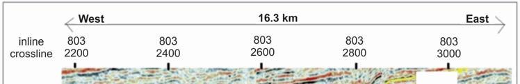
3 Recent phase dominated by thermally- induced subsidence and lacking inversion- related tectonic uplift. The pre- Miocene phase represents the initial extensional phase of basin development, when subsidence was controlled by normal faulting (Hamilton, 1979; Madon, 1999). Sedimentation was characterized by alternating sanddominated and shale-dominated fluvio-lacustrine sequences within a series of isolated half-graben (Madon, 1999). The Early to Middle Miocene post-rift phase was dominated by thermal subsidence that was accompanied by intermittent periods of compressional deformation. This resulted in local inversion of syn-rift half-grabens and reactivation of their bounding faults; this was particularly intense in the southern part of the basin (Madon, 1999). During this post-rift phase, deposition was characterized by coastal to shallow marine deposits. The Late Miocene to Recent phase was dominated by thermal subsidence, without any significant tectonic activity (Madon et al., 1999). Deposition during this phase was mainly within coastal plain and shallow marine environments. Figure-2. Generalized stratigraphy and structure history of the Malay Basin. The second column contains the main regional stratigraphic intervals (labeled A-M) and their approximate ages (in Mya) (Modified from Madon, 1999). MATERIALS AND METHODS This study was based on the 3-D seismic data that covering approximately 623 km 2 in the study area, northeast Malay Basin, which is a half-graben and anticline structures in the study area. The seismic data were recorded and processed during 1991 while 2851
4 exploration borehole data were tied to the seismic survey to complement and calibrate seismic interpretations in cases where the relatively low-resolution data were ambiguous. The chronostratigraphic column was used to estimate the ages of strata and sequence boundaries. In order to choose the most prominent seismic reflectors as sequence boundaries, all possible sequence boundaries were initially identified in a high-quality migrated seismic refletion section. The lateral extent of each probable sequence boundary was evaluated through correlation across of the seismic sections. The fundamental concept of seismic sequence analysis is that every seismic section is divided into relatively conformable or concordant seismic reflectors. They were then tied to well and dated. Then, seismic facies analysis was conducted to correlate reflection attribute and identify stratigraphic sequence characteristics between seismic and well data. Three characteristics of reflection attributes were used to distinguish between different seismic facies which are frequency, internal reflector configuration and amplitude strength. This methods used in the present study is set out below. The sequence boundaries identified on seismic reflection data were calibrated together with a exploration well. Every identified seismic facies type was correlated with well data to establish a relationship between the seismic facies and lithofacies. Time to depth conversion has been done by the average velocity model based on time-depth relationship for the well. Depositional systems and facies associations in strata of Lower Miocene-Recent were delineated by interpreting 2-D and 3-D highresolution seismic profiles and analyzing well log. Sequence boundaries (unconformity interfaces) of the Lower Miocene-Recent strata succession were identified on seismic profiles as onlap surfaces or truncation surfaces, and in well-log data as abrupt change surfaces. These interpretations served as a foundation for understanding the structural style and the composite stratigraphic sequence framework. After a regionally consistent seismic sequence, stratigraphic framework was constructed and chronostartigraphic data were used to calibrate the seismic interpretations by age intervals. The depositional systems and cycles were identified from synthetic seismogram of well-log data. At this stage, systems tracts were defined in relation to the sequence boundaries and maximum flooding surfaces appearing on seismic profiles as downlap surfaces, and as condensed sections in well logs. RESULTS AND DISCUSSIONS Sequence stratigraphic and facies analysis In this study, the sequence boundaries (seismic units) are determined from the well logs data and the observation of the seismic facies from 2-D seismic section. Eight sequence boundaries featured particular reflection patterns and geological ages as shown in Figure-3. The oldest sequence boundary interpreted was the basement layer; hence indicating the basement of the study area. The depth and two-way time information for five top formations are observed from the time-depth curve. In addition, the three sequence boundaries are found from the 2-D seismic sections by the amplitudes and the appearance of facies differentiation. After establishing the sequence boundaries, the seismic facies in the units were identified. Each unit, known as a Group, is bounded by basin-wide seismic reflectors. Some of these reflectors represent major sequence boundaries and are erosional unconformities on the basin flanks. Based on seismic data and well log, the facies of every sequence boundaries from SB1 (the oldest) until SB8 (the youngest) are observed. Lithology influence on amplitudes can often be recognized by the pattern of amplitudes as observed on horizon slices and by understanding how different lithologies occur within a deposition system. By relating lithologies to depositional systems we often refer to these as lithofacies or facies. The link between amplitude characteristics and depositional patterns makes it easier to distinguish lithofacies variations and fluid changes in the seismic section and well logs. 2852
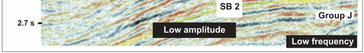
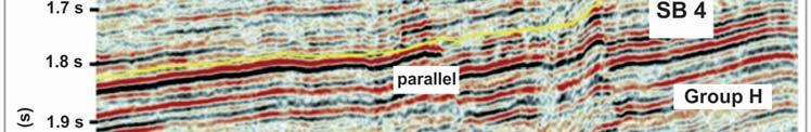
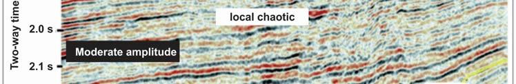
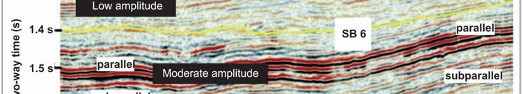
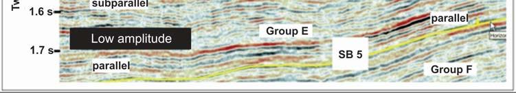
5 Figure-3. The sequence boundaries for seismic inline-803. The interpretation were used the lithostratigraphic log from the well- A. Upper oligocene to lower miocene sequence (SB 1) Reflection characteristics of this sequence are represented by chaotic pattern, low amplitude and lowfrequency. The Upper Oligocene to Lower Miocene sequence was indicated as syn-rift unit, and is determined as extensional phase of basin development. The unit is characterized by chaotic, low amplitude and low frequency. This sequence is classified as Group K and the sediments were initially deposited in islolated grabens and half-grabens, with thick deposits of alternating sanddominated and shale-dominated, fluvio-lacustrine sequences. These sediments consist of fan delta and highenergy fluvial deposits, alluvial plain and lacustrine sediments, which were deposited in relatively shallow lacustrine environments. These deposits show increasing lacustrine influence towards the basin centre. Group K has an estimated average thickness of 400m, and consists of sandstone and shale deposited in braided rivers in alluvial fans and delta complexes (Mazlan et al. 1999a; HIS 2004). According to Khalid (2010), he concluded that the Group K is best developed in the west and central parts of the southern Malay Basin, with over 600 m of sediments in the west. This group consists of thick alluvial-plain deposits, comprising braided channel sandstone and siltstone, and lower coastal/ delta- plain deposits. Lower miocene to upper miocene sequence (SB 2- SB 6) The Late Lower Miocene to Upper Miocene sequence were including the Group J, I, H, F, E and D. The transition from lacustrine shale (Group K) to marine sandstone (Group J) marks a significant change in the depositional history of the basin. The first marine incursion is dated at between 18.7 to 21 Ma (mid Early Miocene) at the top of Group K (Azmi et al. 1996). Subsequent Groups J to D sediments were deposited during the post-rift phase which lasted till Late Miocene. The middle Lower to Middle Miocene sediments were deposited in marine, tidal-estuarine, coastal plain and fluvial environments. Groups J and I consist of progradational to aggradational fluvial to tidal- estuarine sandstone. The Group J sequence that has chaotic facies is developed after the deposition where the deformation occurred and the anticline produced (Figure-4). This is because after these chaotic facies, there is sub-parallel facies were occurred. The amplitude in the upper part of sequence is moderate and the lower part shows the low amplitude strength. The frequency in this sequence is low. The Group J sequence with average thickness of 250 m and consisting of shale and sandstones sequences, deposited in a tidally influence coastal fluvio-marine environment. Sandstones are mainly of tidal flats, channels and shoreface facies. The lower Group J was deposited in sub-tidal sand bars, trending WNW-ESE parallel to the palaeo-shoreline. The Group I sequence is characterized by subparallel to parallel configuration, low amplitude and low frequency (Figure-5) with average thickness 300 m, comprises shale, coaly shale, sandstone and coal. The basin was probably at or near sea level by Early Miocene 2853
6 time, as indicated by the abundance of coal-bearing strata in the succession. Basin inversion commenced in late Early Miocene, corresponding to the top of group I. The Groups H and F sequence sediments were deposited during an overall sea-level rise and are dominated by marine to deltaic sediments with fluvial/ estuarine channels. Reflection characteristics of Group H sequence are represented by local chaotic pattern, sub-parallel to parallel configuration, moderate amplitude and moderate frequency (Figure-6). This group section is mainly composed of shales interbedded with siltstones, thin sandstones and abundant coaly beds. The sandstones made up of point bars and channels are interpreted to have been deposited in a lower coastal plain environment with tidal and marine influences. This sequence is about 63 m thick. Reflection characteristics of the Group F sequence are represented by sub-parallel to parallel facies and also chaotic pattern that are exist because of the deformation from the existence of faults. There is parallel facies in the upper part of Group F sequence (Figure-7). Hilly facies or a little chaotic pattern in the lower part of this sequence is proposed that the sediment deposition in the area is relatively high energy. This sequence has moderate to high amplitude and frequency. The Group F section is comprised of alternating shales and siltstones with minor sandstones beds and is about 181 m thick. This sequence deposited in coastal fluvial plain environment with varying tidal influence. The Group E sequence consists of sandstones interbedded with shales and siltstones. Coaly beds can be seen scattered through out the section. The sandstones thickness ranges from 3 m to 20 m are made up of channel and point bar sandstones deposited in lower coastal plain environment. This sequence is about 370 m thick. This sequence is characterized by sub-parallel to parallel facies and moderate to high amplitude and frequency (Figure-8). The deposition of Groups D, E and F sediments continued in the central and northern parts of the basin, while the southern part was uplifted and underwent erosion. The top of the Group D sequence is marked by the Pliocene/ Miocene Unconformity. It is about 136 m thick. It is comprised of intercalated clay stones, siltstones and sandstones deposited in a delta front environment with varying lagoonal and tidal flat influences. Figure-9 show the facies in the Group D sequence that characterized by the existence of sub- parallel to parallel facies and low amplitude and frequency. Pliocene to recent sequence (SB 8) This sequence was indicated as a phase of gentle subsidence and fully open-marine environments were established. Groups A/ B sediments consist. These groups are undifferentiated and form the youngest and thickest sequence and are about 1008 m thick. They mainly made up of unconsolidated clay stones and siltstones rich in fossils and pyrite. The sediments are interpreted to have been deposited in an inner neritic to holomarine environment. The Group B sequence is characterized by parallel configuration and high amplitude and frequency (Figure-10). These parallel facies shows the uniformity during the stable sediment deposition. Figure-4. Facies in the Group J sequence. 2854


7 Figure-5. Facies in the Group I sequence. Figure-6. Facies in the Group H sequence. 2855


8 Figure-7. Facies in the Group F sequence. Figure-8. Facies in the Group E sequence. 2856


 to the border of SB 8 (older) sequence.")


9 Figure-9. Facies in the Group D sequence. Figure-10. Facies in the Group B sequence. CONCLUSIONS A seismic interpretation of the Malay Basin has been made based on seismic data in the form of 3-D and using cross-sectional data that is supported by the analysis of seismic data recording to the well sediments of Lower Miocene to Pliocene age. A total of eight sequences boundaries have been identified in the study area (northeast Malay Basin), which are labelled as SB1 (younger) to the border of SB 8 (older) sequence. Sequence boundary that obtained is determined by the presence of the indicated amount of termination deposition showed end of a deposition such as onlaps, downlap and toplap. Sequence boundary SB1, lower Miocene aged, around 18.7 million years ago meanwhile, SB2 also lower Miocene age of 16 million years ago. There is a sequence boundary SB3, Miocene aged around 13.5 million years ago. Sequence boundary SB4, as well as Miocene age with the age of about 12.5 million years ago. SB5 and SB6 sequence boundary, upper Miocene aged respectively 11 and 10.5 million years ago.sequence boundary SB7, Pliocene aged about 6 million years ago and the youngest sequence boundary SB8, Pliocene to Recent age of 1.5 million years ago. The three types of seismic reflection attributes were recognized in the seismic section including the amplitude strength, frequency and internal configuration. 2857
10 ACKNOWLEDGEMENTS We acknowledged Petroleum Management Unit (PMU) team under PETRONAS for allowing us to access seismic profiles and well of northeast Malay Basin. We would like to thank Mr Joseph Gnapragasan from SMT Kingdom for teaching the seismic interpretation using the 8.8 Kingdom software. REFERENCES Catuneanu O., Abreu V., Bhattacharya J.P., and Blum M.D Toward the standardization of sequence stratigraphy. Earth-Science Reviews. 92:1-33. Folkestad A. and Satur N Regressive and transgressive cycles in a rift- basin: depositional model and sedimentary partitioning of the Middle Jurassic Hugin Formation, southern Viking Graben, North Sea. Sedimentary Geology 207: Hamilton W Tectonics of Indonesian region. United States Geological Survey Professional Paper: Hutchison C.S Geological Evolution of South East Asia. Oxford monographs on Geology and Geophysics no.13 Clarendon Press, Oxford. Khalid Ngah, Mazlan Madon and Tjia H.D Role of pre-tertiary fractures in formation and development of the Malay and Penyu basins. In: Hall R. and Blundell D (eds). Tectonic Evolution of Southeast Asia. Geological Society of London Special Publication, 106: Lin C.S., Eriksson K. and Li S.T Sequence architecture, depositional systems, and controls on development of lacustrine basin fills in part of Erlian Basin, Northeast China. AAPG Bulletin. 85: Madon M Basin types, tectono- stratigraphic provinces, structural styles. In: Petronas (ed.) The Petroleum Geology and Resources of Malaysia. Petronas, Kuala Lumpur. pp Madon M. and Watts A.B Gravity anomalies, subsidence history and the tectonic evolution of the Malay and Penyu Basins (offshore Peninsular Malaysia). Basin Research. 10: Agbada Formation, Robertkiri field, Niger Delta, Nigeria. AAPG Bulletin. 91: NikRamli Depositional model of a Miocene barred wave and storm-dominated shoreface and shelf, southeastern Malay Basin, offshore West Malaysia. American Association of Petroleum Geologists Bulletin. 70: Shanley K.W., McCabe P.J Perspectives on the sequence stratigraphy of continental strata: AAPG Bulletin 78: Strecker U., Stridtmann J.R. and Smithson A Conceptual tectonostratigraphic model for seismic facies migration in a fluvio-lacustrine extensional basin. AAPG Bulletin. 83: Tjia H.D Inversion tectonics in the Malay Basin: evidence and timing of events. Geological Society of Malaysia Bulletin. 36: Tjia H.D. and Liew K.K Changes in tectonic stress field in northern Sunda Shelf basins. In: Hall, R and Blundell, D.J. (eds.), Tectonic Evolution of Southeast Asia. Geological Society of London Special Publication. 106: Vail P.R. and Mitchum R.M Seismic stratigraphy and global change of sea-level, part 1: seismic stratigraphy applications to hydrocarbon exploration. Dlm. Payton, C.E. (pnyt). AAPG Memoir. 26: Van Wagoner J.C., Mitchum R.M., Campion K.M. and Rahmanian V.D Siliclastic sequence stratigraphy in well logs, cores and outcrops: concepts for high-resolution correlation of time and facies: AAPG Methods in Exploration Series. p. 55. Zcchin M., Mellere d., and Roda C Sequence stratigraphy and architectural variability in growth faultbounded basin fills: a review of Plio-Pleistocene stratal units of Croton basin, southern Italy. Journal of the Geological Society. 163, Madon M, Abolins P, Jamaal Hoesni M, Ahmad M Malay Basin. In: Petronas (ed.) The Petroleum Geology and Resources of Malaysia. Petronas, Kuala Lumpur. pp Magbegbeola O.A. and Willis B Sequence stratigraphy and syndepositional deformation of the 2858
Seismic Stratigraphy of the Fang Basin, Chiang Mai, Thailand Rungsun Nuntajun
 Chiang Mai J. Sci. 2009; 36(1) 77 Chiang Mai J. Sci. 2009; 36(1) : 77-82 www.science.cmu.ac.th/journal-science/josci.html Contributed Paper Seismic Stratigraphy of the Fang Basin, Chiang Mai, Thailand
Seismic stratigraphy, some examples from Indian Ocean, interpretation of reflection data in interactive mode
 Seismic stratigraphy, some examples from Indian Ocean, interpretation of reflection data in interactive mode K. S. Krishna National Institute of Oceanography, Dona Paula, Goa-403 004. krishna@nio.org Seismic
Sedimentary Cycle Best Practice: Potential Eo-Oligocene Sediments in Western Indonesia*
 Sedimentary Cycle Best Practice: Potential Eo-Oligocene Sediments in Western Indonesia* Mellinda Arisandy 1 and I Wayan Darma 1 Search and Discovery Article #11008 (2017)** Posted November 6, 2017 *Adapted
Bulletin of Earth Sciences of Thailand
 Quantitative Seismic Geomorphology of Early Miocene to Pleistocene Fluvial System of Northern Songkhla Basin, Gulf of Thailand Oanh Thi Tran Petroleum Geoscience Program, Department of Geology, Faculty
Meandering Miocene Deep Sea Channel Systems Offshore Congo, West Africa
 Meandering Miocene Deep Sea Channel Systems Offshore Congo, West Africa S. Baer* (PGS), J. E. Comstock (PGS), K. Vrålstad (PGS), R. Borsato (PGS), M. Martin (PGS), J.P. Saba (SNPC), B. Débi-Obambé (SNPC)
SEQUENCE STRATIGRAPHY OF THE LATE PALEOCENE-PLIO- PLEISTOCENE DEPOSITS, CENTRAL TARANAKI BASIN, NEW ZEALAND
 SEQUENCE STRATIGRAPHY OF THE LATE PALEOCENE-PLIO- PLEISTOCENE DEPOSITS, CENTRAL TARANAKI BASIN, NEW ZEALAND Abd Alsalam Almasgari 1, 2 and Umar Hamzah 1 1 Department of Geology, School of Environmental
Case Study of the Structural and Depositional-Evolution Interpretation from Seismic Data*
 Case Study of the Structural and Depositional-Evolution Interpretation from Seismic Data* Yun Ling 1, Xiangyu Guo 1, Jixiang Lin 1, and Desheng Sun 1 Search and Discovery Article #20143 (2012) Posted April
Southern Songkhla Basin, Gulf of Thailand
 Architecture and Depositional Environment of Fluvial Systems of Southern Songkhla Basin, Gulf of Thailand Toan Manh Do Petroleum Geoscience Program, Department of Geology, Faculty of Science, Chulalongkorn
Depositional Sequences Sequences
 Depositional Sequences Transgressive and Regressive packages can be bound by unconformities Because sediment can only be preserved during net aggradation and progradation All other times there is either
Depositional History and Petroleum Potential of Ombilin Basin, West Sumatra - Indonesia, Based on Surface Geological Data*
 Depositional History and Petroleum Potential of Ombilin Basin, West Sumatra - Indonesia, Based on Surface Geological Data* Yahdi Zaim 1, Litto Habrianta 2, Chalid I. Abdullah 1, Aswan 1, Yan Rizal 1, Nurcahyo
Bulletin of Earth Sciences of Thailand. Controls on Reservoir Geometry and Distribution, Tantawan Field, Gulf of Thailand.
 Controls on Reservoir Geometry and Distribution, Tantawan Field, Gulf of Thailand Atchara Praidee Petroleum Geoscience Program, Department of Geology, Faculty of Science, Chulalongkorn University, Bangkok
Geol 755: Basin Analysis Geophysics Week 4.5. Seismic Stratigraphy Basics. Seismic Sequence Analysis. Seismic Sequence Analysis
 Geol 755: Basin Analysis Geophysics Week 4.5 John N. Louie, Presenter Seismic Stratigraphy Basics Reflector Terminations Sequence Boundary Identification Procedure Example Objective: Define the genetic
Introduction to sequence stratigraphy and its application to reservoir geology
 Introduction to sequence stratigraphy and its application to reservoir geology Massimo Zecchin Istituto Nazionale di Oceanografia e di Geofisica Sperimentale - OGS Historical development Definitions Systems
A Simplified Guide For Sequence Stratigraphy:
 SEPM Society for Sedimentary Geology A Simplified Guide For Sequence Stratigraphy: Nomenclature, Definitions and Method Vitor Abreu President - SEPM Abstract All attempts to codify Sequence Stratigraphy
Structural Style and Tectonic Evolution of the Nakhon Basin, Gulf of Thailand
 Structural Style and Tectonic Evolution of the Nakhon Basin, Gulf of Thailand Piyaphong Chenrai Petroleum Geoscience Program, Department of Geology, Faculty of Science, Chulalongkorn University, Bangkok
Well Logs 3 D Seismic Sequence Stratigraphy Evaluation of Holu Field, Niger Delta, Nigeria
 Well Logs 3 D Seismic Sequence Stratigraphy Evaluation of Holu Field, Niger Delta, Nigeria John O. Amigun 1, Olumide Adewoye 1, Temitope Olowolafe 1 and Emmanuel Okwoli 2 1 Department of Applied Geophysics,
Carboniferous Stoddart Group: An integrated approach
 Carboniferous Stoddart Group: An integrated approach Abu Yousuf*, Department of Geoscience, University of Calgary, Calgary, Alberta yousufabu@hotmail.com and Charles M. Henderson, Department of Geoscience,
Controls on clastic systems in the Angoche basin, Mozambique: tectonics, contourites and petroleum systems
 P2-2-13 Controls on clastic systems in the Angoche basin, Mozambique: tectonics, contourites and petroleum systems Eva Hollebeek, Olivia Osicki, Duplo Kornpihl Schlumberger, London, UK Introduction Offshore
Sequence Stratigraphy as a tool for water resources management in alluvial coastal aquifers: application to the Llobregat delta (Barcelona, Spain)
") Sequence Stratigraphy as a tool for water resources management in alluvial coastal aquifers: application to the Llobregat delta (Barcelona, Spain) Desiré Gàmez Torrent December 2007 CHAPTER 1: Introduction
Sequence Stratigraphy as a tool for water resources management in alluvial coastal aquifers: application to the Llobregat delta (Barcelona, Spain) Desiré Gàmez Torrent December 2007 CHAPTER 1: Introduction
Hydrocarbon Potential of the Marginal Fields in Niger Delta Oza Field, a case study*
 Hydrocarbon Potential of the Marginal Fields in Niger Delta Oza Field, a case study* J.N. Sahu 1, C.H.V. Satya Sai 1, V. Chintamani 1 and C. Vishnu Vardhan 1 Search and Discovery Article #20182 (2012)*
PROCEEDINGS, INDONESIAN PETROLEUM ASSOCIATION Forty-First Annual Convention & Exhibition, May 2017
 IPA17-369-SG PROCEEDINGS, INDONESIAN PETROLEUM ASSOCIATION Forty-First Annual Convention & Exhibition, May 2017 FACIES ANALYSIS OF LATE NEOGENE DEPOSIT: MARINE TO CONTINENTAL ENVIRONMENT OF THE MERAPI
Vail et al., 1977b. AAPG 1977 reprinted with permission of the AAPG whose permission is required for further use.
 Well 5 Well 4 Well 3 Well 2 Well 1 Vail et al., 1977b AAPG 1977 reprinted with permission of the AAPG whose permission is required for further use. Well 5 Well 4 Well 3 Well 2 Well 1 Vail et al., 1977b
Maturity Modeling of Gomin and South Gomin fields Southern Pattani Basin, Gulf of Thailand
 Maturity Modeling of Gomin and South Gomin fields Southern Pattani Basin, Gulf of Thailand Patinya Jaithan Petroleum Geoscience Program, Department of Geology, Faculty of Science, Chulalongkorn University,
Quantitative Seismic Geomorphology of Fluvial Systems of the Pleistocene to Recent in the Malay Basin, Southeast Asia*
 Quantitative Seismic Geomorphology of Fluvial Systems of the Pleistocene to Recent in the Malay Basin, Southeast Asia* Faisal Alqahtani 1, Christopher Jackson 1, Howard Johnson 1, Alex Davis 2, and Ammar
SAND DISTRIBUTION AND RESERVOIR CHARACTERISTICS NORTH JAMJUREE FIELD, PATTANI BASIN, GULF OF THAILAND
 SAND DISTRIBUTION AND RESERVOIR CHARACTERISTICS NORTH JAMJUREE FIELD, PATTANI BASIN, GULF OF THAILAND Benjawan KIinkaew Petroleum Geoscience Program, Department of Geology, Faculty of Science, Chulalongkorn
Fluvial-Estuarine and Deltaic Reservoirs, Shelf Margin Delta and Slope Reservoir Characteristics Philip Sedore 2015
 Fluvial-Estuarine and Deltaic Reservoirs, Shelf Margin Delta and Slope Reservoir Characteristics Philip Sedore 2015 Introduction The offshore Columbus Basin and the onshore Southern Basin of Trinidad are
DATA ANALYSIS AND INTERPRETATION
 III. DATA ANALYSIS AND INTERPRETATION 3.1. Rift Geometry Identification Based on recent analysis of modern and ancient rifts, many previous workers concluded that the basic structural unit of continental
Bulletin of Earth Sciences of Thailand. A study of Reservoir Connectivity in the Platong Field, Pattani Basin, Gulf of Thailand. Hathairat Roenthon
 A study of Reservoir Connectivity in the Platong Field, Pattani Basin, Gulf of Thailand Hathairat Roenthon Petroleum Geoscience Program, Department of Geology, Faculty of Science, Chulalongkorn University,
Accommodation. Tectonics (local to regional) Subsidence Uplift
 Subsidence Uplift") Accommodation Accommodation varies over time; it is the distance between a reference horizon and the sea surface (i.e. relative sea level). The space to be filled in with sediments or water What are the
Accommodation Accommodation varies over time; it is the distance between a reference horizon and the sea surface (i.e. relative sea level). The space to be filled in with sediments or water What are the
Blocks 31, 32, 33, 34, 35 & 36/03 Southeast Offshore Vietnam
 Blocks 31, 32, 33, 34, 35 & 36/03 Southeast Offshore Vietnam Block 31 32 33 34 35 36/03 Area (km 2) 5,036 4,440 4,630 4,700 4,630 2,950 Sea level (m) 20 20-30 30-40 50 50 50 Seismic 2D (km) 1,294 685 431
Ministry of Oil and Minerals Petroleum Exploration & Production Authority BLOCK 6 (Iryam)
") Ministry of Oil and Minerals Petroleum Exploration & Production Authority BLOCK 6 (Iryam) The Iryam Block (6) occupies an area of 3,911 km 2 in the Sabatayn Basin in the province of Shabwah in central
Ministry of Oil and Minerals Petroleum Exploration & Production Authority BLOCK 6 (Iryam) The Iryam Block (6) occupies an area of 3,911 km 2 in the Sabatayn Basin in the province of Shabwah in central
MUHAMMAD S TAMANNAI, DOUGLAS WINSTONE, IAN DEIGHTON & PETER CONN, TGS Nopec Geological Products and Services, London, United Kingdom
 Geological and Geophysical Evaluation of Offshore Morondava Frontier Basin based on Satellite Gravity, Well and regional 2D Seismic Data Interpretation MUHAMMAD S TAMANNAI, DOUGLAS WINSTONE, IAN DEIGHTON
Bulletin of Earth Sciences of Thailand. Evaluation of the Petroleum Systems in the Lanta-Similan Area, Northern Pattani Basin, Gulf of Thailand
 Evaluation of the Petroleum Systems in the Lanta-Similan Area, Northern Pattani Basin, Gulf of Thailand Sirajum Munira Petroleum Geoscience Program, Department of Geology, Faculty of Science, Chulalongkorn
Integrated well log and 3-D seismic data interpretation for the Kakinada area of KG PG offshore basin
 IOSR Journal of Applied Geology and Geophysics (IOSR-JAGG) e-issn: 2321 0990, p-issn: 2321 0982.Volume 5, Issue 4 Ver. II (Jul. Aug. 2017), PP 01-05 www.iosrjournals.org Integrated well log and 3-D seismic
The Late Tertiary Deep-Water Siliciclastic System of the Levant Margin - An Emerging Play Offshore Israel*
 The Late Tertiary Deep-Water Siliciclastic System of the Levant Margin - An Emerging Play Offshore Israel* Michael A. Gardosh 1, Yehezkel Druckman 2 and Binyamin Buchbinder 2 Search and Discovery Article
Bulletin of Earth Sciences of Thailand
 Depositional Environments and Stratigraphic Development of the Grand Taman Sari Circuit Outcrop: an Analogue for Transgressive Mahakam Delta Successions Ridha Santika Riadi Petroleum Geoscience Program,
Horizontal Well Injector/Producer Pair Platong Field, Pattani Basin, Thailand*
 Horizontal Well Injector/Producer Pair Platong Field, Pattani Basin, Thailand* Abhiphat Pakdeesirote 1, Sonchawan Ackagosol 3, Sarayoot Geena 3, Nualjun Kitvarayut 3, Kenneth Lewis 2, Tom Tran 3, Nancy
Stratigraphic Plays in Active Margin Basin: Fluvio-Deltaic Reservoir Distribution in Ciputat Half Graben, Northwest Java Basin*
 Stratigraphic Plays in Active Margin Basin: Fluvio-Deltaic Reservoir Distribution in Ciputat Half Graben, Northwest Java Basin* Ary Wahyu Wibowo 1, Astri Pujianto 1, Wisnu Hindadari 1, Arief Wahidin Soedjono
EGAS. Ministry of Petroleum
 EGAS Ministry of Petroleum EGAS Ministry of Petroleum About The Block Location: N. Thekah offshore block is located at about 56 km to the north of the Mediterranean shore line, 85 km to the north west
Ministry of Oil and Minerals Petroleum Exploration & Production Authority BLOCK 85 (Al Uqlah North)
") Ministry of Oil and Minerals Petroleum Exploration & Production Authority BLOCK 85 (Al Uqlah North) The Al Uqlah North Block (85) occupies an area of 597 km 2 in the Sabatayn Basin in the province of Shabwah
Ministry of Oil and Minerals Petroleum Exploration & Production Authority BLOCK 85 (Al Uqlah North) The Al Uqlah North Block (85) occupies an area of 597 km 2 in the Sabatayn Basin in the province of Shabwah
Kilometre-Scale Uplift of the Early Cretaceous Rift Section, Camamu Basin, Offshore North-East Brazil*
 Kilometre-Scale Uplift of the Early Cretaceous Rift Section, Camamu Basin, Offshore North-East Brazil* Iain Scotchman 1 and Dario Chiossi 2 Search and Discovery Article #50183 (2009) Posted May 20, 2009
Sequence Stratigraphic Framework and Reservoir Architecture of the Lingshui-3 Member, Yacheng 13-1 Gas Field, South China Sea
 Sequence Stratigraphic Framework and Reservoir Architecture of the Lingshui-3 Member, Yacheng 13-1 Gas Field, South China Sea David Z. Tang BP China Exploration and Production Company 17/F, Finance Centre,
Multiattributes and Seismic Interpretation of Offshore Exploratory Block in Bahrain A Case Study
 Multiattributes and Seismic Interpretation of Offshore Exploratory Block in Bahrain A Case Study Suresh Thampi, Aqeel Ahmed, Yahya Al-Ansari, Ali Shehab, Ahmed Fateh, Anindya Ghosh, Ghada Almoulani. The
II. REGIONAL GEOLOGY
 II. REGIONAL GEOLOGY 2.1. Regional Plate Tectonic Setting The geological history of the East Java basin is closely related to tectonic activity of the Southeast Asia especially the Western Indonesia region.
Abstract. Introduction. Regional Setting. GCSSEPM to be published December 2003
 Shelf Margin Deltas and Associated Deepwater Deposits: Implications on Reservoir Distribution and Hydrocarbon Entrapment, Block VI-1, Ulleung Basin, East Sea, South Korea Sneider, John S. Sneider Exploration,
EGAS. Ministry of Petroleum
 EGAS Ministry of Petroleum EGAS Ministry of Petroleum About The Block Location: N. El Arish offshore block is located in the extreme eastern part of the Egypt s economic water border and bounded from the
Geological Evolution of Bago-Yoma Basin, Onshore Myanmar*
 Geological Evolution of Bago-Yoma Basin, Onshore Myanmar* Seehapol Utitsan 1, Teekayu Benjawan 1, Suppakarn Thanatit 1, Wirote Wetmongkongorn 1, U. Soe Than 2, Khun Hline Myint 1, and Ler Bwe Wah 1 Search
Structural Geology of the Mountains
 Structural Geology of the Mountains Clinton R. Tippett Shell Canada Limited, Calgary, Alberta clinton.tippett@shell.ca INTRODUCTION The Southern Rocky Mountains of Canada (Figure 1) are made up of several
OUTCROP! CHARACTERISATION! OF! TRANSGRESSIVE! SANDSTONE! RESERVOIRS:! QUANTITATIVE!COMPARISON!OF!OUTCROP!ANALOGUES!
 OUTCROP CHARACTERISATION OF TRANSGRESSIVE SANDSTONE RESERVOIRS: QUANTITATIVECOMPARISONOFOUTCROPANALOGUES OLIVER D. JORDAN 1, PETER J. SIXSMITH 2, GARY J. HAMPSON, SANJEEV GUPTA & HOWARDD.JOHNSON DepartmentofEarthScienceandEngineering,ImperialCollegeLondon,SouthKensington
P. S. Basak, Ravi Kant, K. Yasodha, T. Mukherjee, P. Rajanarayana, Sucheta Dotiwala, V. K. Baid, P.H. Rao, V. Vairavan, ONGC
 P-483 Summary Delineation of pinch-outs within Panna Formation of Paleocene-Early Eocene sequence in and around South Mumbai Low to Identify Prospective Areas - A Case Study P. S. Basak, Ravi Kant, K.
Geometric attributes such as coherence and curvature are
 SATINDER CHOPRA, Arcis Seismic Solutions, Calgary, Canada KURT J. MARFURT, University of Oklahoma, Norman, USA Geometric attributes such as coherence and curvature are commonly used for mapping structural
Seismic Expressions of Submarine Channel - Levee Systems and Their Architectural Elements
 Seismic Expressions of Submarine Channel - Levee Systems and Their Architectural Elements Summary D.V. Ramana, Santanu De* and Kalyanbrata Datta KDMIPE, ONGC, Dehradun E-mail- devvenram@rediffmail.com
Sequence Stratigraphy. Historical Perspective
 Sequence Stratigraphy Historical Perspective Sequence Stratigraphy Sequence Stratigraphy is the subdivision of sedimentary basin fills into genetic packages bounded by unconformities and their correlative
Petroleum Prospectivity in the Namibe and Southern Benguela Basins, Offshore Angola
 Petroleum Prospectivity in the Namibe and Southern Benguela Basins, Offshore Angola C. Koch* (PGS), F. Pepe (PGS), R. Vasconcelos (PGS), F. Mathew (PGS), R. Borsato (PGS) & M.P.C. de Sá (Sonangol) SUMMARY
Sedimentary and Stratigraphic Analysis of the Viking Sand in the Edgerton/Wainwright Area, Central Alberta* By Russell Walz 1
 Sedimentary and Stratigraphic Analysis of the Viking Sand in the Edgerton/Wainwright Area, Central Alberta* By Russell Walz 1 Search and Discovery Article #50030 (2006) Posted June 25, 2006 *Extended abstract
Pre-Feasibility Report
 Pre-Feasibility Report Project Details: The Block MB-OSN-2005/1 is a Saurashtra shallow water block situated between GS-OSN- 2003/1(NELP-V) in the west, C-37/C-43 PEL in the east and Saurashtra - Dahanu
REGIONAL GEOLOGY IN KHMER BASIN
 CONTENTS 1-Khmere Basin 2-Regional Geology Khmer Basin 3-Regime Tectonic 4-Seismic Database -a/ Acquisition Data -b/ Prospect Angkor -C/ Cross Section Seismic 5-Play Type -a/ Play Schematic -b/ Structure
EVALUATION OF SEISMIC ATTRIBUTES OF APO FIELD, ONSHORE NIGER DELTA, SOUTHERN NIGERIA
 EVALUATION OF SEISMIC ATTRIBUTES OF APO FIELD, ONSHORE NIGER DELTA, SOUTHERN NIGERIA Ekpe G. A 1, Emudianughe J. E 2 and Umukoro J 3 1 Department of Geology, University of Port Harcourt, Port Harcourt,
Supplementary Material for Eighty million years of folding migration: new perspective on the Syrian Arc from Levant basin analysis
 GSA Data Repository 2018040 https://doi.org/10.1130/g39654.1 Supplementary Material for Eighty million years of folding migration: new perspective on the Syrian Arc from Levant basin analysis Sagy Yael,
Turbidites Characterization from Seismic Stratigraphy Analysis: Application to the Netherlands Offshore F3 Block*
 Turbidites Characterization from Seismic Stratigraphy Analysis: Application to the Netherlands Offshore F3 Block* E. Illidge 1, J. Camargo 1, and J. Pinto 1 Search and Discovery Article #41952 (2016)**
Relinquishment Report. for. Licence P1605, Block 220/27
 Relinquishment Report for Licence P1605, Block 220/27 November 2013 Licence P.1605 Relinquishment Report August 2012 1 of 11 CONTENT 1 Introduction 2 - Exploration Summary 2.1 Exploration Activity 2.2
The Stratigraphic Trap in the Benchamas Field Pattani Basin, Gulf of Thailand
 The Stratigraphic Trap in the Benchamas Field Pattani Basin, Gulf of Thailand Jurairat Buangam Petroleum Geoscience Program, Department of Geology, Faculty of Science, Chulalongkorn University, Bangkok
Orphan Basin, Offshore Newfoundland: New seismic data and hydrocarbon plays for a dormant Frontier Basin
 Orphan Basin, Offshore Newfoundland: New seismic data and hydrocarbon plays for a dormant Frontier Basin Jerry Smee* G&G Exploration Consulting, 301 400-3rd Avenue SW, Calgary, AB, T2P 4H2 Sam Nader, Paul
BALOCHISTAN FOLDBELT BASIN
 INTRODUCTION BALOCHISTAN FOLDBELT BASIN The Kharan-3 block is located in the Kharan Trough of Balochistan Basin. GEOLOGICAL SETTING The Balochistan Province is an Upper Cretaceous to Recent structurally
Answers: Internal Processes and Structures (Isostasy)
") Answers: Internal Processes and Structures (Isostasy) 1. Analyse the adjustment of the crust to changes in loads associated with volcanism, mountain building, erosion, and glaciation by using the concept
Answers: Internal Processes and Structures (Isostasy) 1. Analyse the adjustment of the crust to changes in loads associated with volcanism, mountain building, erosion, and glaciation by using the concept
OIL INDIA LIMITED, GEOPHYSICS DEPARTMENT, DULIAJAN, ASSAM.
 J. P. Singh, M. K. Gupta & Akshaya Kumar, Oil India Limited, Duliajan. jpsingh@oilindia.in Summary Oil exploration in Upper Assam commenced with the discovery of the Digboi oilfield more than 100 years
Figure 1: Location and bathymetry of the study area. Gulf of Guinea. Cameroon. Congo. Gabon. PGS/DGH Gabon MegaSurvey Coverage (35000Km 2 ) Eq.
 Eq.") Deepwater hydrocarbon prospectivity analysis of offshore North and South Gabon Muhammad S Tamannai (*), Thomas Hansen (1), Ron Borsato (1), Jennifer Greenhalgh (1) Martial-Rufin Moussavou (2) & Landry
Deepwater hydrocarbon prospectivity analysis of offshore North and South Gabon Muhammad S Tamannai (*), Thomas Hansen (1), Ron Borsato (1), Jennifer Greenhalgh (1) Martial-Rufin Moussavou (2) & Landry
Biostratigraphic and Lithostratigraphic Correlation of Sedimentary Strata in the Atlantic Coastal Plain
 Biostratigraphic and Lithostratigraphic Correlation of Sedimentary Strata in the Atlantic Coastal Plain Introduction to the Atlantic Coastal Plain (Please read this page prior to doing the lab) The Atlantic
AAPG International Conference: October 24-27, 2004; Cancun, Mexico
 and Seismic Attributes in the Continental Shelf of Eastern Mexico Khaled Fouad, L. Frank Brown, Jr., William A. Ambrose, Dallas Dunlap, Bureau of Economic Geology, Jackson School of Geosciences, The University
SEDIMENTARY BASINS Red Sea Coast of Egypt. by Prof. Dr. Abbas Mansour
 SEDIMENTARY BASINS Red Sea Coast of Egypt by Prof. Dr. Abbas Mansour Sedimentary basins Sedimentary basins are, in a very broad sense, all those areas in which sediments can accumulate to considerable
The Impact of Parasequence Stacking Patterns on Vertical Connectivity Between Wave-Dominated, Shallow Marine Parasequences, Book Cliffs, Eastern Utah
 The Impact of Parasequence Stacking Patterns on Vertical Connectivity Between Wave-Dominated, Shallow Marine Parasequences, Book Cliffs, Eastern Utah MALCOLM J. ARNOT and TIMOTHY R. GOOD* MALCOLM J. ARNOT
Improved Interpretability via Dual-sensor Towed Streamer 3D Seismic - A Case Study from East China Sea
 Improved Interpretability via Dual-sensor Towed Streamer 3D Seismic - A Case Study from East China Sea S. Rongfu (CNOOC Shanghai), C. Hua (CNOOC Shanghai), W. Yun (CNOOC Shanghai), Z. Yabin (CNOOC Shanghai),
Dalhousie University- Petroleum Geoscience Field Methods- Trinidad Summary Report
 Dalhousie University- Petroleum Geoscience Field Methods- Trinidad Summary Report Submitted to: Offshore Energy Research Association of Nova Scotia (OERA) To fulfill requirements of the Undergraduate Student
A comparison of structural styles and prospectivity along the Atlantic margin from Senegal to Benin. Peter Conn*, Ian Deighton* & Dario Chisari*
 A comparison of structural styles and prospectivity along the Atlantic margin from Senegal to Benin Overview Peter Conn*, Ian Deighton* & Dario Chisari* * TGS, Millbank House, Surbiton, UK, KT6 6AP The
The reconstruction of 3D geo-lithological model of Pekan, Pahang: A possible onshore extension of Penyu Basin
 , pp. 63 67 The reconstruction of 3D geo-lithological model of Pekan, Pahang: A possible onshore extension of Penyu Basin Ashley Aisyah Yoong, Abdul Ghani Md Rafek, Khairul Arifin Mohd Noh * & Radziamir
Chapter 3. Geology & Tectonics
 Chapter 3 Geology & Tectonics 3.1 Geology The general geological features of Indonesia are shown in Figure 3.1. The basement formation is metamorphic and it is intruded with plutonic formations. They are
Seismic Geomorphology in the Late Cenozoic Depositional Evolution of the Gulf of Thailand
 Research article Seismic Geomorphology in the Late Cenozoic Depositional Evolution of the Gulf of Thailand Worawat Maharernthong, Piyaphong Chenrai* and Montri Choowong Department of Geology, Faculty of
APPENDIX C GEOLOGICAL CHANCE OF SUCCESS RYDER SCOTT COMPANY PETROLEUM CONSULTANTS
 APPENDIX C GEOLOGICAL CHANCE OF SUCCESS Page 2 The Geological Chance of Success is intended to evaluate the probability that a functioning petroleum system is in place for each prospective reservoir. The
Seismic interpretation. Principles of seismic stratigraphic interpretation
 Seismic interpretation Principles of seismic stratigraphic interpretation Seismic interpretation Seismic stratigraphy is a technical for interpreting stratigraphic information from seismic data. The resolution
Structural Framework and Deep-Marine Depositional Environments of Miocene- Pleistocene Sequence in Western Offshore Myanmar
 P-58 Structural Framework and Deep-Marine Depositional Environments of Miocene- Pleistocene Sequence in Western Offshore Myanmar Mukesh Jain*, Prabal Shankar Das, Bidesh Bandyopadhyay Summary The western
Regional Paleogeography and Implications for Petroleum Prospectivity, Taranaki Basin, New Zealand*
 Regional Paleogeography and Implications for Petroleum Prospectivity, Taranaki Basin, New Zealand* Dominic P. Strogen 1, Kyle J. Bland 1, Jan R. Baur 1,2, and Peter R. King 1 Search and Discovery Article
Sequence Stratigraphic Framework of the Paradise-Field Niger Delta, Nigeria.
 Sequence Stratigraphic Framework of the Paradise-Field Niger Delta, Nigeria. A.O. Anyiam, M.Sc. and A.W. Mode, Ph.D. Department of Geology, University of Nigeria, Nsukka, Enugu State, Nigeria E-mail: okwy_anyiam@yahoo.com
Sequence Stratigraphic Analysis from Well Logs of an X- Field, Niger Delta, Nigeria
 Current Research in Geosciences Original Research Paper Sequence Stratigraphic Analysis from Well Logs of an X- Field, Niger Delta, Nigeria Godwin Omokenu Emujakporue and Alphonsus Joseph Eyo Department
Tim Carr - West Virginia University
 Tim Carr - West Virginia University Understanding Seismic Data Resolution (Vertical and Horizontal) Common Depth Points (CDPs) Two way time (TWT) Time versus depth Interpretation of Reflectors 2 Able to
Seismic lab exercises
 Seismic lab exercises SEISMIC LAB 1st Exercise This type of analysis involves taking either seismic or geologic cross-sections and building a chronostratigraphic chart. Chronostratigraphic charts, also
Shallow Gas Prospect Evaluation in Shahbazpur Structure Using Seismic Attributes Analysis - a Case Study for Bhola Island, Southern Bangladesh
 Dhaka Univ. J. Sci. 64(2): 135-140, 2016 (July) Shallow Gas Prospect Evaluation in Shahbazpur Structure Using Seismic Attributes Analysis - a Case Study for Bhola Island, Southern Bangladesh Morshedur
Seismic interpretation of carbonate turbidites in Central Luconia
 GeoL. Soc. MaLayaia, BuLLetin 47, December 2005; pp. 77-85 Seismic interpretation of carbonate turbidites in Central Luconia FRANcis Ho, GUENTER JAEGER AND PmT LAMBREGTS Sarawak Shell Berhad SMEP Exploration
An Evolutionary Model of the Near-shore Tinjar and Balingian Provinces, Sarawak, Malaysia
 International Journal of Petroleum and Geoscience Engineering (IJPGE) 2 (1): ISSN 2289-4713 Academic Research Online Publisher Research paper An Evolutionary Model of the Near-shore Tinjar and Balingian
Structural Geology Lab. The Objectives are to gain experience
 Geology 2 Structural Geology Lab The Objectives are to gain experience 1. Drawing cross sections from information given on geologic maps. 2. Recognizing folds and naming their parts on stereoscopic air
1.1 INTRODUCTION TO THE PROJECT:
 .Chapter 1: Introduction 1.1 INTRODUCTION TO THE PROJECT: Stratigraphic correlation in Ransi Member in the Tatau-Bintulu area of Sarawak, East Malaysia has always been difficult, due to the lack of large
entered a rapid development phase. Annual increased proven reserves are above 500 billion cubic meters (bcm) from 2003, and annual natural gas product
 from 2003, and annual natural gas product") (), entered a rapid development phase. Annual increased proven reserves are above 500 billion cubic meters (bcm) from 2003, and annual natural gas production has increased from 50bcm in 2000 to nearly
(), entered a rapid development phase. Annual increased proven reserves are above 500 billion cubic meters (bcm) from 2003, and annual natural gas production has increased from 50bcm in 2000 to nearly
Application of seismic attributes and neural network for sand probability prediction A case study in the North Malay Basin
 Bulletin of the Geological Society of Malaysia 54 (2008) 115 121 Application of seismic attributes and neural network for sand probability prediction A case study in the North Malay Basin Ji a n y o n
SEDIMENTARY BASINS BASIN TYPES ACCORDING TO TECTONIC. by Prof. Dr. Abbas Mansour
 SEDIMENTARY BASINS BASIN TYPES ACCORDING TO TECTONIC by Prof. Dr. Abbas Mansour B. Convergent plate margins 10. STABLE CONTINENTAL INTERIOR BASIN E.g. Lake Eyre Basin Intracratonic (= within stable continental
Structural Styles and Geotectonic Elements in Northwestern Mississippi: Interpreted from Gravity, Magnetic, and Proprietary 2D Seismic Data
 Structural Styles and Geotectonic Elements in Northwestern Mississippi: Interpreted from Gravity, Magnetic, and Proprietary 2D Seismic Data Nick Loundagin 1 and Gary L. Kinsland 2 1 6573 W. Euclid Pl.,
High-resolution Sequence Stratigraphy of the Glauconitic Sandstone, Upper Mannville C Pool, Cessford Field: a Record of Evolving Accommodation
 Page No. 069-1 High-resolution Sequence Stratigraphy of the Glauconitic Sandstone, Upper Mannville C Pool, Cessford Field: a Record of Evolving Accommodation Thérèse Lynch* and John Hopkins, Department
CLASTICS FIELD TRIP. Dynamic stratigraphy, facies, architecture and fracture analysis of coastal depositional systems
 CLASTICS FIELD TRIP Dynamic stratigraphy, facies, architecture and fracture analysis of coastal depositional systems MAY 2-5 SEPTEMBER 17-20, 2018 Appraisal and development of clastic reservoirs rely on
Trapping Mechanisms along North Similan and Lanta Trends, Pattani Basin, Gulf of Thailand
 Trapping Mechanisms along North Similan and Lanta Trends, Pattani Basin, Gulf of Thailand Piyaporn Aukkanit Petroleum Geoscience Program, Department of Geology, Faculty of Science, Chulalongkorn University,
Dakota Sandstone. of the Moxa Arch and Surrounding Green River Basin
 Dakota Sandstone of the Moxa Arch and Surrounding Green River Basin Dakota Sandstones of the Green River Basin Overview The Dakota sandstones of the Moxa Arch and surrounding Green River Basin remain attractive
Depositional Environments. Depositional Environments
 Depositional Environments Geographic area in which sediment is deposited Characterized by a combination of geological process & environmental conditions Depositional Environments Geological processes:
Perspectives from Offshore Argentina & Uruguay
 Perspectives from Offshore Argentina & Uruguay A Prospectivity Overview Hannah Kearns October 2018 Introduction Argentina Offshore License Round 1 14 blocks Argentina North, 24 Austral-Malvinas Offshore