Horizontal Well Injector/Producer Pair Platong Field, Pattani Basin, Thailand*
|
|
|
- Buck Woods
- 6 years ago
- Views:
Transcription
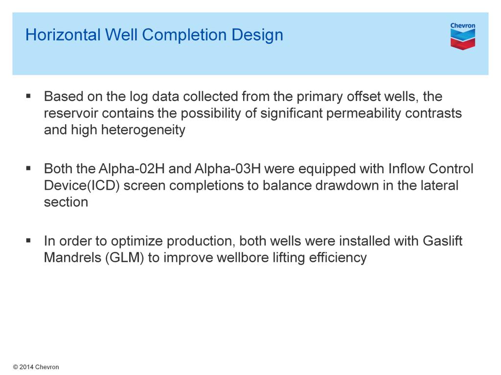
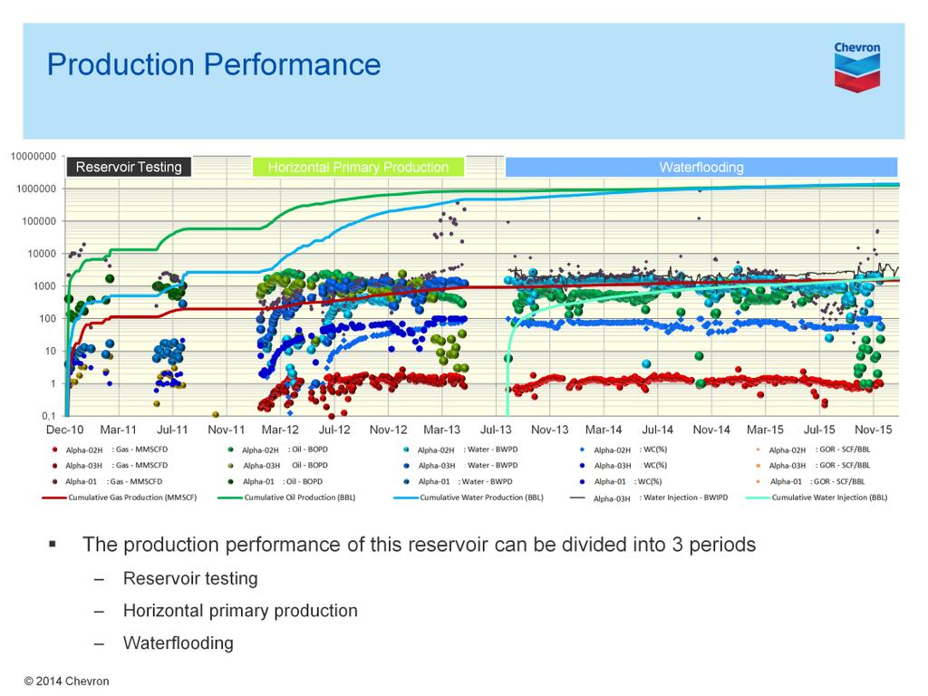
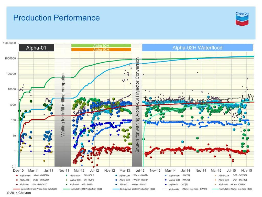
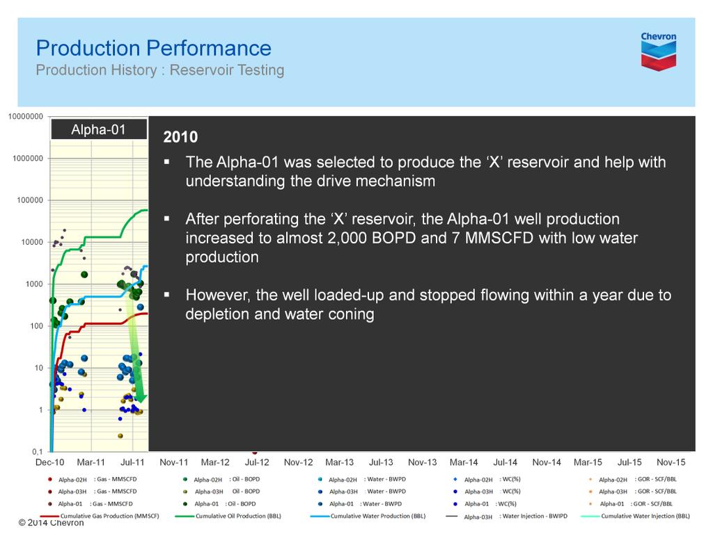
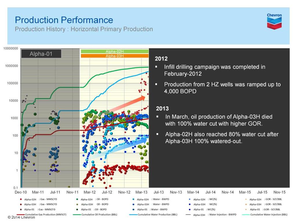
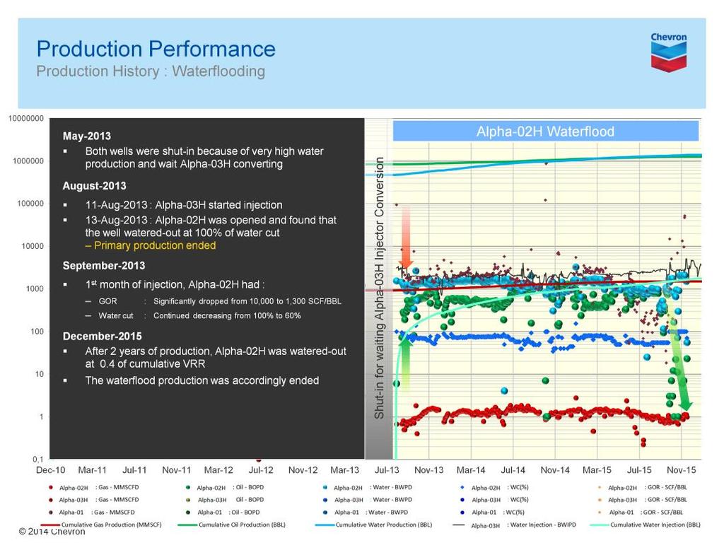
1 Horizontal Well Injector/Producer Pair Platong Field, Pattani Basin, Thailand* Abhiphat Pakdeesirote 1, Sonchawan Ackagosol 3, Sarayoot Geena 3, Nualjun Kitvarayut 3, Kenneth Lewis 2, Tom Tran 3, Nancy Wildman 3, Achiraya Soodsai 3, and Pattra Viriyasittigun 3 Search and Discovery Article #20354 (2016)** Posted June 20, 2016 *Adapted from oral presentation given at AAPG Geosciences Technology Workshop, Characterization of Asian Hydrocarbon Reservoirs, Bangkok, Thailand, March 31 April 1, 2016 **Datapages 2016 Serial rights given by author. For all other rights contact author directly. 1 Chevron Thailand Exploration and Production Ltd., Bangkok Thailand (AbhiphatP@chevron.com) 2 Chevron Thailand Exploration and Production Ltd., Bangkok Thailand (kenneth.lewis@chevron.com) 3 Chevron Thailand Exploration and Production Ltd., Bangkok Thailand Abstract The X Trend in the Pattani Basin of the Gulf of Thailand commenced oil production in The trend consists of a series of North-South oriented complexly faulted, extensional collapse grabens, and tilted half grabens. The Miocene-age clastic reservoirs can be generally characterized as small-compartmentalized fluvial reservoirs (5-60 feet in thickness). The reservoir sands are composed of multiple channel sands that have locally complex vertical and areal stacking patterns. Connectivity within these reservoirs is impacted by potential barriers including both mud-filled abandoned channels and fault compartmentalization. Primary oil production is typically low due to an absence of aquifer support. Waterflooding has been implemented to improve hydrocarbon recovery and sustain field production. The Alpha Platform was infilled in 2012 with two horizontal wells (Alpha-02H and Alpha-03H). The two infill horizontal wells targeted a >25 oil column in the X reservoir sand which had a single existing deviated producer (Alpha-01) with low produced oil volumes due to water coning without gaslift capability. Both the Alpha-02H and Alpha-03H horizontal sections were placed at the same structural elevation below the gas cap in the upper portion of the oil leg. The wells were completed with three strings of casing and equipped with inflow control devices (ICD) and gas lift mandrels (GLM). Production commenced in February 2012 with combined oil production from the two horizontals ramping up to close to 4,000 bopd before both wells died with >90% water cut in February Alpha-03H was converted to a waterflood injector in August 2013 and commenced injection in the same month. After one month of maintaining a voidage replacement ratio (VRR) of 1:1 at Alpha03H, the Alpha-02H GOR and water cut dropped substantially with oil production ramping up to close to 1,000 bopd. After waterflooding in December 2014 the reservoir, pressure had improved significantly. Within the two-year period of waterflooding, the Alpha- 02H watered out and died. The horizontal waterflooding period has ended and the project s recovery factor (RF) is >30%. The Recovery Factor contribution from waterflood operations was >10%.
2 The reservoirs in the Gulf of Thailand are very complex and the reserves are quite marginal to develop. For these reasons, no dynamic modeling was attempted for this complexly faulted fluvial sand. A statistical model based on historical data was utilized to predict the benefit from both horizontal wells and waterflood operations. A comparison of current analogous reservoirs in the same trend with completed deviated injector/producer water floods shows about 50% higher recovery factor for this horizontal injector/producer waterflood. The main lesson learned from utilizing horizontal wells as injectors is that it allows more flexibility in waterflood implementation and reservoir management strategy in complexly faulted reservoirs and potentially better connectivity leading to higher ultimate recovery factors. In order to capitalize on horizontal waterflood strategies it is necessary to fully utilize cross functional team work to identify target reservoirs from primary drilling programs and optimize production data by developing routine sampling collection methodologies. Selected Reference Jardine, E., 1997, Dual Petroleum Systems Governing the Prolific Pattani Basin, Offshore Thailand: Proceedings of the International Conference on Stratigraphic and Tectonic Evolution of Southeast Asia and the South Pacific (Geothai 97), August 1997, Department of Mineral Resources, Bangkok, p

3
4

5 Presenter s notes: This is an overview slide of the Asia and SE Asia tectonic setting leading to the origin of the Gulf of Thailand. The image on the left shows the tectonic setting from Late Cretaceous to Eocene time as the Indo-Australian plate separated from Gondwanaland moving northwards to collide with the Eurasian plate. This formed a major thrust fault and subduction zone related to the plate collision with the Indo-Australian oceanic crust being subducted. This subduction opened the Gulf of Thailand 50Ma with back-arc extension transpression/transtension associated with right-lateral strike-slip faulting (shown on the figure to the right).

6 Presenter s notes: Looking closer at the formation of the Gulf Thailand Basins we see north-south extensional faults forming these Cenozic Basins which link up with the NNW trending Three Pagoda Transfer Fault. The Pattani Basin is one of eleven N-S elongate pull-apart basins in the Gulf of Thailand associated with Eocene/Oligocene oblique slip. The Western and Eastern Gulf of Thailand sub-segments are separated from one another by the Ko Kra Ridge with nine basins in the west and three basins in the east: the Pattani and Malay Basins and the smaller Khmer Basin. The Pattani Basin, which is the focus of this presentation is the largest basin in the Gulf. Five sequences were recognized by Jardine in 1997 based on seismic reflection and well data.

7 Presenter s notes: The next two slides detail the Gulf of Thailand Basin Evolution from Late Cretaceous to Present Day. The section is West to East across the Pattani and Khmer Basins. From Late Cretaceous to Eocene the India Plate separates from Gondwanaland moving north to collide with the Eurasian Craton. The resulting uplift creates the Pre-Tertiary Unconformity From Late Eocene to Late Oligocene is the Himalayan Orogeny due to India-Eurasian plate collision. This creates the Mae-Ping and Three Pagoda Shear Systems and the elongate N-S rifted sub-basins Sequence 1 Rift-fill deposits are Late Oligocene reddish brown claystones and siltstones predominate in lacustrine to alluvial deposits. At the End of the Oligocene wrenching along the Mae-Ping and Three Pagoda Faults causes uplift and creates the Mid-Tertiary Unconformity During the Lower Miocene continued clockwise rotation creates renewed extension and rifting. Sequence 2 Lower Redbeds formed as fluvial point bar and channel deposits in North and Central Pattani and Upper intertidal, fluvial and lower deltaic plains in the southern basin.

8 Presenter s notes: Continued clockwise rotation of the Indochina block during the Middle Miocene leads to post-rife collapse and basin subsidence. Sequence 3 Lower Grey Beds which are coastal plain and marginal marine deposits and Sequence 4 Upper Redbed point bar and channel fill deposits in the fluvial-floodplain are deposited during this time period. Eustatic sea-level drop during the Latest-Middle to Early Upper Miocene creates the MMU unconformity. Sequence 5, the youngest unit, was deposited from Upper Miocene to Present during continued compression and rotation with the basins continuing to subside and deepen. The Upper Gray Beds were deposited during a regional marine transgression and are delta plain to shallow marine deposits.

9 Presenter s notes: This Simplified Strat Column for the South Pattani Basin shows the generalized lithologies from the Pre-Tertiary Complex up through Sequences #1 to #5 from the Oligocene to Present Day. The sample seismic line shows each sequence in a different color and highlights the extensive faulting through the entire section Source rock potential ranges from Sequence#1 to Sequence #3 deposits and Hydrocarbon potential from Sequence #2 to #4 deposits between the Mid-Tertiary to Mid-Miocene Unconformity. The sandstone with the horizontal injector producer pair that we are going to discuss today is a Mid-Miocene point bar sand at the top of the Upper Red Bed Sequence #4 near the Mid-Miocene Unconformity.
.")
10 Presenter s notes: Here is a typical map view and three well strat section through these Mid-Miocene Pattani Basin fluvial deposits. They are generally characterized as small compartmentalized fluvial reservoirs (5-50 feet in thickness). The reservoir sands are composed of multiple channel sands that have locally complex vertical and areal stacking patterns. Connectivity within these reservoirs is impacted by potential barriers including both mud-filled abandoned channels and fault compartmentalization. Primary oil production is typically low due to an absence of aquifer support. Waterflooding has been implemented to improve hydrocarbon recovery and sustain field production.

11 Presenter s notes: Here is a map view of the horizontal injector/producer pair. The offsetting deviated well control are the grey dots and the fault polygons are shown as black outlines. Well control from fourteen wells with 400m well spacing defines the channel belt margins and a NNW-SSE orientation which is typically for the Pattani Basin. The Stratigraphic Cross Section North to South from A-A with highlighted GR curves shows approx. 60 foot thick point bar sand and a stacked 40 foot thick point bar deposit in one of the wells. The RMS amplitude high amplitude response which are the green, yellow and red colors correlates well with the existing well control to define the margins of the thicker and more aerially extensive point bar deposit. The lower amplitude response which are the pink and blue colors represents the abandoned channel mud-fill and flood plain deposits.

12 Presenter s notes: So if we plot the point bar sand thickness vs. RMS amplitude response we see a good correlation between low amplitude response and sand thickness for the Non-Point Bar wells shown in Brown. We also see a good correlation between the single thick point bar deposit wells and high amplitude response shown in yellow. The one well with the stacked point bar deposit having the highest amplitude and thickest sand thickness. There are two wells which are anomalous. One with no sand thickness having a relatively high amplitude response and one well with 40 sand thickness having a relatively low amplitude response.

13 Presenter s notes: If we use the combination of well control and RMS amplitude to define the point bar edges and sand thickness shaded in yellow we can estimate our reserve size based on a net-to-gross ratio of 98% in the point bar wells. Average porosity is ~30% and average water saturation is ~40% to give an estimated oil in place of 4 MMbbls for this Mid-Miocene point bar sand. The abandoned mud-filled channel deposits acting as a flow barrier are outlined by the thin black lines.

14 Presenter s notes: The map on the left is a structure map on top of the sand based on well control and seismic and shows the two horizontal wells Alpha-02H and Alpha-03H which were drilled as platform infill wells in The contour interval is 10 with red being structural highs. Structural cross sections along both horizontal wells are shown on the right. The two infill horizontal wells targeted a >25 oil column in a reservoir sand which had a single existing deviated producer (Alpha-01) with low produced oil volumes due to water coning. The primary gas cap and water legs in the the point bar can be seen with both wells placed at the same structural elevation approximately 1/3 2/3 between the gas/oil and oil/water contacts. Each horizontal has ~600m lateral section.
15
16
17
18
19
20

21
Bulletin of Earth Sciences of Thailand. Controls on Reservoir Geometry and Distribution, Tantawan Field, Gulf of Thailand.
 Controls on Reservoir Geometry and Distribution, Tantawan Field, Gulf of Thailand Atchara Praidee Petroleum Geoscience Program, Department of Geology, Faculty of Science, Chulalongkorn University, Bangkok
SAND DISTRIBUTION AND RESERVOIR CHARACTERISTICS NORTH JAMJUREE FIELD, PATTANI BASIN, GULF OF THAILAND
 SAND DISTRIBUTION AND RESERVOIR CHARACTERISTICS NORTH JAMJUREE FIELD, PATTANI BASIN, GULF OF THAILAND Benjawan KIinkaew Petroleum Geoscience Program, Department of Geology, Faculty of Science, Chulalongkorn
Bulletin of Earth Sciences of Thailand. Evaluation of the Petroleum Systems in the Lanta-Similan Area, Northern Pattani Basin, Gulf of Thailand
 Evaluation of the Petroleum Systems in the Lanta-Similan Area, Northern Pattani Basin, Gulf of Thailand Sirajum Munira Petroleum Geoscience Program, Department of Geology, Faculty of Science, Chulalongkorn
REGIONAL GEOLOGY IN KHMER BASIN
 CONTENTS 1-Khmere Basin 2-Regional Geology Khmer Basin 3-Regime Tectonic 4-Seismic Database -a/ Acquisition Data -b/ Prospect Angkor -C/ Cross Section Seismic 5-Play Type -a/ Play Schematic -b/ Structure
Bulletin of Earth Sciences of Thailand. A study of Reservoir Connectivity in the Platong Field, Pattani Basin, Gulf of Thailand. Hathairat Roenthon
 A study of Reservoir Connectivity in the Platong Field, Pattani Basin, Gulf of Thailand Hathairat Roenthon Petroleum Geoscience Program, Department of Geology, Faculty of Science, Chulalongkorn University,
Bulletin of Earth Sciences of Thailand
 Quantitative Seismic Geomorphology of Early Miocene to Pleistocene Fluvial System of Northern Songkhla Basin, Gulf of Thailand Oanh Thi Tran Petroleum Geoscience Program, Department of Geology, Faculty
Sedimentary Cycle Best Practice: Potential Eo-Oligocene Sediments in Western Indonesia*
 Sedimentary Cycle Best Practice: Potential Eo-Oligocene Sediments in Western Indonesia* Mellinda Arisandy 1 and I Wayan Darma 1 Search and Discovery Article #11008 (2017)** Posted November 6, 2017 *Adapted
The Stratigraphic Trap in the Benchamas Field Pattani Basin, Gulf of Thailand
 The Stratigraphic Trap in the Benchamas Field Pattani Basin, Gulf of Thailand Jurairat Buangam Petroleum Geoscience Program, Department of Geology, Faculty of Science, Chulalongkorn University, Bangkok
Geological Evolution of Bago-Yoma Basin, Onshore Myanmar*
 Geological Evolution of Bago-Yoma Basin, Onshore Myanmar* Seehapol Utitsan 1, Teekayu Benjawan 1, Suppakarn Thanatit 1, Wirote Wetmongkongorn 1, U. Soe Than 2, Khun Hline Myint 1, and Ler Bwe Wah 1 Search
Geologic influence on variations in oil and gas production from the Cardium Formation, Ferrier Oilfield, west-central Alberta, Canada
 Geologic influence on variations in oil and gas production from the Cardium Formation, Ferrier Oilfield, west-central Alberta, Canada Marco Venieri and Per Kent Pedersen Department of Geoscience, University
Main Challenges and Uncertainties for Oil Production from Turbidite Reservoirs in Deep Water Campos Basin, Brazil*
 Main Challenges and Uncertainties for Oil Production from Turbidite Reservoirs in Deep Water Campos Basin, Brazil* Carlos H. Bruhn 1, Antonio Pinto 1, and Paulo R. Johann 1 Search and Discovery Article
Maturity Modeling of Gomin and South Gomin fields Southern Pattani Basin, Gulf of Thailand
 Maturity Modeling of Gomin and South Gomin fields Southern Pattani Basin, Gulf of Thailand Patinya Jaithan Petroleum Geoscience Program, Department of Geology, Faculty of Science, Chulalongkorn University,
Vail et al., 1977b. AAPG 1977 reprinted with permission of the AAPG whose permission is required for further use.
 Well 5 Well 4 Well 3 Well 2 Well 1 Vail et al., 1977b AAPG 1977 reprinted with permission of the AAPG whose permission is required for further use. Well 5 Well 4 Well 3 Well 2 Well 1 Vail et al., 1977b
Depositional History and Petroleum Potential of Ombilin Basin, West Sumatra - Indonesia, Based on Surface Geological Data*
 Depositional History and Petroleum Potential of Ombilin Basin, West Sumatra - Indonesia, Based on Surface Geological Data* Yahdi Zaim 1, Litto Habrianta 2, Chalid I. Abdullah 1, Aswan 1, Yan Rizal 1, Nurcahyo
Southern Songkhla Basin, Gulf of Thailand
 Architecture and Depositional Environment of Fluvial Systems of Southern Songkhla Basin, Gulf of Thailand Toan Manh Do Petroleum Geoscience Program, Department of Geology, Faculty of Science, Chulalongkorn
Horizontal well Development strategy
 Horizontal well Development strategy Pakawas Mangkang Team Member Yoseph Partono Stephan Otero Duangdao Chutanukarn Warin Lobtong Suarporn Ketpreechasawat B8/32 Asset, Thailand Chiangmai, 11 th Nov-13
Blocks 31, 32, 33, 34, 35 & 36/03 Southeast Offshore Vietnam
 Blocks 31, 32, 33, 34, 35 & 36/03 Southeast Offshore Vietnam Block 31 32 33 34 35 36/03 Area (km 2) 5,036 4,440 4,630 4,700 4,630 2,950 Sea level (m) 20 20-30 30-40 50 50 50 Seismic 2D (km) 1,294 685 431
EGAS. Ministry of Petroleum
 EGAS Ministry of Petroleum EGAS Ministry of Petroleum About The Block Location: N. Thekah offshore block is located at about 56 km to the north of the Mediterranean shore line, 85 km to the north west
Meandering Miocene Deep Sea Channel Systems Offshore Congo, West Africa
 Meandering Miocene Deep Sea Channel Systems Offshore Congo, West Africa S. Baer* (PGS), J. E. Comstock (PGS), K. Vrålstad (PGS), R. Borsato (PGS), M. Martin (PGS), J.P. Saba (SNPC), B. Débi-Obambé (SNPC)
USU 1360 TECTONICS / PROCESSES
 USU 1360 TECTONICS / PROCESSES Observe the world map and each enlargement Pacific Northwest Tibet South America Japan 03.00.a1 South Atlantic Arabian Peninsula Observe features near the Pacific Northwest
Ministry of Oil and Minerals Petroleum Exploration & Production Authority BLOCK 85 (Al Uqlah North)
") Ministry of Oil and Minerals Petroleum Exploration & Production Authority BLOCK 85 (Al Uqlah North) The Al Uqlah North Block (85) occupies an area of 597 km 2 in the Sabatayn Basin in the province of Shabwah
Ministry of Oil and Minerals Petroleum Exploration & Production Authority BLOCK 85 (Al Uqlah North) The Al Uqlah North Block (85) occupies an area of 597 km 2 in the Sabatayn Basin in the province of Shabwah
Pre-Feasibility Report
 Pre-Feasibility Report Project Details: The Block MB-OSN-2005/1 is a Saurashtra shallow water block situated between GS-OSN- 2003/1(NELP-V) in the west, C-37/C-43 PEL in the east and Saurashtra - Dahanu
EGAS. Ministry of Petroleum
 EGAS Ministry of Petroleum EGAS Ministry of Petroleum About The Block Location: N. El Arish offshore block is located in the extreme eastern part of the Egypt s economic water border and bounded from the
Structural Style and Tectonic Evolution of the Nakhon Basin, Gulf of Thailand
 Structural Style and Tectonic Evolution of the Nakhon Basin, Gulf of Thailand Piyaphong Chenrai Petroleum Geoscience Program, Department of Geology, Faculty of Science, Chulalongkorn University, Bangkok
The Late Tertiary Deep-Water Siliciclastic System of the Levant Margin - An Emerging Play Offshore Israel*
 The Late Tertiary Deep-Water Siliciclastic System of the Levant Margin - An Emerging Play Offshore Israel* Michael A. Gardosh 1, Yehezkel Druckman 2 and Binyamin Buchbinder 2 Search and Discovery Article
II. REGIONAL GEOLOGY
 II. REGIONAL GEOLOGY 2.1. Regional Plate Tectonic Setting The geological history of the East Java basin is closely related to tectonic activity of the Southeast Asia especially the Western Indonesia region.
Bulletin of Earth Sciences of Thailand
 AN INTEGRATED VELOCITY MODELING WORKFLOW TO PREDICT RELIABLE DEPTHS IN TRAT FIELD, GULF OF THAILAND Sarayoot Geena Petroleum Geoscience Program, Department of Geology, Faculty of Science, Chulalongkorn
Ministry of Oil and Minerals Petroleum Exploration & Production Authority BLOCK 6 (Iryam)
") Ministry of Oil and Minerals Petroleum Exploration & Production Authority BLOCK 6 (Iryam) The Iryam Block (6) occupies an area of 3,911 km 2 in the Sabatayn Basin in the province of Shabwah in central
Ministry of Oil and Minerals Petroleum Exploration & Production Authority BLOCK 6 (Iryam) The Iryam Block (6) occupies an area of 3,911 km 2 in the Sabatayn Basin in the province of Shabwah in central
EAGE 4 TH Arabian Plate Geology Workshop December Abu Dhabi, UAE & SPWLA Kuwait Chapter meeting 29-Jan-2013
 Structural and Stratigraphic Trapping of Hydrocarbons within Late Jurassic to Early Cretaceous Section as Observed from Drilling and 2-D/3-D Seismic in Partitioned/Divided Zone of Kingdom of Saudi Arabia/Kuwait
Trapping Mechanisms along North Similan and Lanta Trends, Pattani Basin, Gulf of Thailand
 Trapping Mechanisms along North Similan and Lanta Trends, Pattani Basin, Gulf of Thailand Piyaporn Aukkanit Petroleum Geoscience Program, Department of Geology, Faculty of Science, Chulalongkorn University,
The Mesozoic. Wednesday, November 30, 11
 The Mesozoic Periods of the Mesozoic Triassic- First period of the Mesozoic era Jurassic Cretaceous- Last period of the Mesozoic era Breakup of Pangaea Stage one (Triassic) Rifting and volcanism, normal
Sequence Stratigraphy of the Upper Cretaceous Niobrara Formation, A Bench, Wattenberg Field, Denver Julesburg Basin, Colorado*
 Sequence Stratigraphy of the Upper Cretaceous Niobrara Formation, A Bench, Wattenberg Field, Denver Julesburg Basin, Colorado* Lisa E. Remington LaChance 1 and Mark C. Robinson 1 Search and Discovery Article
Petroleum Geology and Exploration History of the Mergui Basin, THAILAND EPPM (P1) PROJECT
 PROJECT") Petroleum Geology and Exploration History of the Mergui Basin, THAILAND EPPM (P1) PROJECT KRABI, THAILAND 12 th May 2009 Contents of Presentation 1. Exploration History 1. Exploration History 2. General
Petroleum Geology and Exploration History of the Mergui Basin, THAILAND EPPM (P1) PROJECT KRABI, THAILAND 12 th May 2009 Contents of Presentation 1. Exploration History 1. Exploration History 2. General
A.K. Khanna*, A.K. Verma, R.Dasgupta, & B.R.Bharali, Oil India Limited, Duliajan.
 P-92 Application of Spectral Decomposition for identification of Channel Sand Body in OIL s operational area in Upper Assam Shelf Basin, India - A Case study A.K. Khanna*, A.K. Verma, R.Dasgupta, & B.R.Bharali,
Figure 1 Extensional and Transform Fault Interaction, Influence on the Upper Cretaceous Hydrocarbon System, Equatorial Margin, West Africa.
 Figure 1 Extensional and Transform Fault Interaction, Influence on the Upper Cretaceous Hydrocarbon System, Equatorial Margin, West Africa. Presented to the 10th PESGB/HGS Conference on Africa E + P September
RELINQUISHMENT REPORT FOR LICENCE P.1663, BLOCK 29/4b and 29/5e
 RELINQUISHMENT REPORT FOR LICENCE P.1663, BLOCK 29/4b and 29/5e Licence: P.1663 Blocks: 29/4b & 29/5e 25th Round Traditional Licence Operator: Ithaca Energy UK(Ltd) 100% Work Programme Summary The agreed
Copyright McGraw-Hill Education. All rights reserved. No reproduction or distribution without the prior written consent of McGraw-Hill Education
 Copyright McGraw-Hill Education. All rights reserved. No reproduction or distribution without the prior written consent of McGraw-Hill Education Tibetan Plateau and Himalaya -southern Asia 11.00.a VE 10X
OIL INDIA LIMITED, GEOPHYSICS DEPARTMENT, DULIAJAN, ASSAM.
 J. P. Singh, M. K. Gupta & Akshaya Kumar, Oil India Limited, Duliajan. jpsingh@oilindia.in Summary Oil exploration in Upper Assam commenced with the discovery of the Digboi oilfield more than 100 years
Hague and London Oil Plc
 Hague and London Oil Plc Exploiting Shallow Gas Offshore Netherlands De-Gassing Shallow Hazards or De-Risking Shallow Gas November 2016 The Shallow Gas Play can be Summarized as Schematic evolution of
The Kingfisher Field, Uganda - A Bird in the Hand! S R Curd, R Downie, P C Logan, P Holley Heritage Oil plc *
 A Bird in the Hand! EXTENDED ABSTRACT The Kingfisher Field, Uganda - A Bird in the Hand! Heritage Oil plc * The Kingfisher Field lies on Uganda s western border beneath Lake Albert, situated in the western
Deformation of Rocks. Orientation of Deformed Rocks
 Deformation of Rocks Folds and faults are geologic structures caused by deformation. Structural geology is the study of the deformation of rocks and its effects. Fig. 7.1 Orientation of Deformed Rocks
Answers: Internal Processes and Structures (Isostasy)
") Answers: Internal Processes and Structures (Isostasy) 1. Analyse the adjustment of the crust to changes in loads associated with volcanism, mountain building, erosion, and glaciation by using the concept
Answers: Internal Processes and Structures (Isostasy) 1. Analyse the adjustment of the crust to changes in loads associated with volcanism, mountain building, erosion, and glaciation by using the concept
Future giant discovery in the Outeniqua Basin, offshore South Africa. Anongporn Intawong & Neil Hodgson
 Future giant discovery in the Outeniqua Basin, offshore South Africa Anongporn Intawong & Neil Hodgson Spectrum Geoscience 23 February 2017 1 Talk Outlines Structural framework & Evolution of the South
Reservoir Management Background OOIP, OGIP Determination and Production Forecast Tool Kit Recovery Factor ( R.F.) Tool Kit
 Tool Kit") Reservoir Management Background 1. OOIP, OGIP Determination and Production Forecast Tool Kit A. Volumetrics Drainage radius assumption. B. Material Balance Inaccurate when recovery factor ( R.F.) < 5 to
Reservoir Management Background 1. OOIP, OGIP Determination and Production Forecast Tool Kit A. Volumetrics Drainage radius assumption. B. Material Balance Inaccurate when recovery factor ( R.F.) < 5 to
Controls on clastic systems in the Angoche basin, Mozambique: tectonics, contourites and petroleum systems
 P2-2-13 Controls on clastic systems in the Angoche basin, Mozambique: tectonics, contourites and petroleum systems Eva Hollebeek, Olivia Osicki, Duplo Kornpihl Schlumberger, London, UK Introduction Offshore
Risk Factors in Reservoir Simulation
 Risk Factors in Reservoir Simulation Dr. Helmy Sayyouh Petroleum Engineering Cairo University 12/26/2017 1 Sources Of Data Petro-physical Data Water saturation may be estimated from log analysis, capillary
Stratigraphic Plays in Active Margin Basin: Fluvio-Deltaic Reservoir Distribution in Ciputat Half Graben, Northwest Java Basin*
 Stratigraphic Plays in Active Margin Basin: Fluvio-Deltaic Reservoir Distribution in Ciputat Half Graben, Northwest Java Basin* Ary Wahyu Wibowo 1, Astri Pujianto 1, Wisnu Hindadari 1, Arief Wahidin Soedjono
Exploration, Drilling & Production
 Nontechnical Guide to PETMOLEUM Geology, Exploration, Drilling & Production Third Edition Norman J. Hyne, Ph.D. Contents Preface *i Introduction 1 The Nature of Gas and Oil 1 Petroleum 1 The Chemistry
Plate Tectonics. entirely rock both and rock
 Plate Tectonics I. Tectonics A. Tectonic Forces are forces generated from within Earth causing rock to become. B. 1. The study of the origin and arrangement of Earth surface including mountain belts, continents,
Relinquishment Report
 Relinquishment Report Licence P1403 Block 13/22d Chevron North Sea Limited Korean National Oil Company Chevron North Sea Limited December 2009 1 SYNOPSIS... 3 2 INTRODUCTION. 3 2.1 Licence Terms.. 3 2.2
FORCES ON EARTH UNIT 3.2. An investigation into how Newton s Laws of Motion are applied to the tectonic activity on Earth.
 FORCES ON EARTH UNIT 3.2 An investigation into how Newton s Laws of Motion are applied to the tectonic activity on Earth. USE THESE NOTES: OUR HOME PLANET EARTH: What do you know about our planet? SO.HOW
Relinquishment Report. for. Licence P1605, Block 220/27
 Relinquishment Report for Licence P1605, Block 220/27 November 2013 Licence P.1605 Relinquishment Report August 2012 1 of 11 CONTENT 1 Introduction 2 - Exploration Summary 2.1 Exploration Activity 2.2
THE NORPHLET SANDSTONE AND OTHER PETROLEUM PLAYS ALONG AND OUTBOARD OF THE FLORIDA ESCARPMENT, EASTERN GULF OF MEXICO
 THE NORPHLET SANDSTONE AND OTHER PETROLEUM PLAYS ALONG AND OUTBOARD OF THE FLORIDA ESCARPMENT, EASTERN GULF OF MEXICO Glyn Roberts 1, Joe Erickson 2 1 Consultant, Bedford, UK; 2 Spectrum, Houston, TX.
Geology 300, Physical Geology Spring 2019 Quiz Ch 19, Plate Tectonics Name
 Geology 300, Physical Geology Spring 2019 Quiz Ch 19, Plate Tectonics Name MULTIPLE CHOICE. Choose the one alternative that best completes the statement or answers the question. 1) The portion of a fracture
December 21, Chapter 11 mountain building E.notebook. Feb 19 8:19 AM. Feb 19 9:28 AM
 Mountains form along convergent plate boundaries. Typically (usually) if you look at a mountain range, you know that it is at a plate boundary (active continental margin) or has been some time in the past
Chapter 10: Deformation and Mountain Building. Fig. 10.1
 Chapter 10: Deformation and Mountain Building Fig. 10.1 OBJECTIVES Describe the processes of rock deformation and compare and contrast ductile and brittle behavior in rocks. Explain how strike and dip
eni s.p.a. upstream & technical services
 eni s.p.a. upstream & technical services 2013-2014 Master in Petroleum Engineering and Operations Congo & Angola Offshore-Congo River Basin Characteristics, exploitation approach and fields analogues Author:
Hydrocarbon Potential of the Marginal Fields in Niger Delta Oza Field, a case study*
 Hydrocarbon Potential of the Marginal Fields in Niger Delta Oza Field, a case study* J.N. Sahu 1, C.H.V. Satya Sai 1, V. Chintamani 1 and C. Vishnu Vardhan 1 Search and Discovery Article #20182 (2012)*
PLATEAU UPLIFT, EPEIROGENEY AND CLIMATE CHANGES The KALAHARI PLATEAU, a world class laboratory
 PLATEAU UPLIFT, EPEIROGENEY AND CLIMATE CHANGES The KALAHARI PLATEAU, a world class laboratory F. Guillocheau M. De Wit G. Dubois B. Linol F. Eckardt W. Cotterill D. Rouby C. Robin Géosciences-Rennes Université
A) B) C) D) 4. Which diagram below best represents the pattern of magnetic orientation in the seafloor on the west (left) side of the ocean ridge?
 B) C) D) 4. Which diagram below best represents the pattern of magnetic orientation in the seafloor on the west (left) side of the ocean ridge?") 1. Crustal formation, which may cause the widening of an ocean, is most likely occurring at the boundary between the A) African Plate and the Eurasian Plate B) Pacific Plate and the Philippine Plate C)
1. Crustal formation, which may cause the widening of an ocean, is most likely occurring at the boundary between the A) African Plate and the Eurasian Plate B) Pacific Plate and the Philippine Plate C)
Description of faults
 GLG310 Structural Geology Description of faults Horizontal stretch Crustal thickness Regional elevation Regional character Issues Normal Thrust/reverse Strike-slip >1 1 in one direction and < 1 in
General Geologic Setting and Seismicity of the FHWA Project Site in the New Madrid Seismic Zone
 General Geologic Setting and Seismicity of the FHWA Project Site in the New Madrid Seismic Zone David Hoffman University of Missouri Rolla Natural Hazards Mitigation Institute Civil, Architectural & Environmental
Seismic stratigraphy, some examples from Indian Ocean, interpretation of reflection data in interactive mode
 Seismic stratigraphy, some examples from Indian Ocean, interpretation of reflection data in interactive mode K. S. Krishna National Institute of Oceanography, Dona Paula, Goa-403 004. krishna@nio.org Seismic
Geologic Mapping Invitational Trial Event
 Geologic Mapping Invitational Trial Event A TEAM OF UP TO: 2 Team Name AVAILABLE TIME: 50 min Required Materials: Each team MUST have a protractor, ruler, non-programmable calculator, colored pencils,
North Sea Business Unit. Fay Licence Relinquishment
 North Sea Business Unit Fay Licence Relinquishment P.1260, Block 22/2b (Premier Oil 100% Operator) Section Contents 1 Header 2 Synopsis 3 Exploration Activities 4 Prospect Analysis 5 Reserves Summary 6
POTENTIAL STRATIGRAPHIC PLAY IN THE WESTERN HA LONG BASIN FROM 3D SEISMIC INVERSION AND REGIONAL GEOLOGICAL CONTEXT
 PETROLEUM EXPLORATION & PRODUCTION POTENTIAL STRATIGRAPHIC PLAY IN THE WESTERN HA LONG BASIN FROM 3D SEISMIC INVERSION AND REGIONAL GEOLOGICAL CONTEXT Nguyen Du Hung 1, Hoang Viet Bach 1, Ngo Van Quan
Mountains are then built by deforming crust: Deformation & Mountain Building. Mountains form where stresses are high!
 Deformation & Mountain Building Where are mountains located? Deformation and Folding Mountain building Mountains form where stresses are high! Mountains form at all three types of plate boundaries where
4D stress sensitivity of dry rock frame moduli: constraints from geomechanical integration
 Title 4D stress sensitivity of dry rock frame moduli: constraints from geomechanical integration Authors Bloomer, D., Ikon Science Asia Pacific Reynolds, S., Ikon Science Asia Pacific Pavlova, M., Origin
Neotectonic Implications between Kaotai and Peinanshan
 Neotectonic Implications between Kaotai and Peinanshan Abstract Longitudinal Valley was the suture zone between the Philippine Sea plate and the Eurasia plate. Peinanshan was the southest segment of the
The Maule Field: An Economic Small Field Development
 AUSTRALIA ARGENTINA CANADA EGYPT NORTH SEA U.S. CENTRAL U.S. GULF The Maule Field: An Economic Small Field Development J. Pyle*, K. Koster, G. Barker and P. Rose Introduction 2 Eocene penetrations with
Petroleum Potential of the Application Area L12-4
 Petroleum Potential of the Application Area L12-4 The Application Area (L12-4) is underlain by the western Officer Basin, beneath the Gunbarrel Basin. The general basin architecture is outlined in Figure
EAS 233 Geologic Structures and Maps Winter Miscellaneous practice map exercises. 1. Fault and separation:
 Miscellaneous practice map exercises 1. Fault and separation: With respect to Map 1, what are (a) the orientation of the fault, and (b) the orientation of bedding in the units cut by the fault. (c) Mark
FORCES ON EARTH. An investigation into how Newton s Laws of Motion are applied to the tectonic activity on Earth.
 FORCES ON EARTH An investigation into how Newton s Laws of Motion are applied to the tectonic activity on Earth. GEOLOGY Geologists scientists who study the forces that make and shape the Earth Geologists
Do NOT open the test until instructed to do so.
 Raw Score: Rank: School: Team Number: Names: Boyceville Invitational, December 2, 2017 Dynamic Planet Plate Tectonics and Geographical Impacts Do NOT open the test until instructed to do so. 2011 Tohoku
Chapter 3. Geology & Tectonics
 Chapter 3 Geology & Tectonics 3.1 Geology The general geological features of Indonesia are shown in Figure 3.1. The basement formation is metamorphic and it is intruded with plutonic formations. They are
Continental Landscapes
 Continental Landscapes Landscape influenced by tectonics, climate & differential weathering Most landforms developed within the last 2 million years System moves toward an equilibrium Continental Landscapes
Case Study of the Structural and Depositional-Evolution Interpretation from Seismic Data*
 Case Study of the Structural and Depositional-Evolution Interpretation from Seismic Data* Yun Ling 1, Xiangyu Guo 1, Jixiang Lin 1, and Desheng Sun 1 Search and Discovery Article #20143 (2012) Posted April
BALOCHISTAN FOLDBELT BASIN
 INTRODUCTION BALOCHISTAN FOLDBELT BASIN The Kharan-3 block is located in the Kharan Trough of Balochistan Basin. GEOLOGICAL SETTING The Balochistan Province is an Upper Cretaceous to Recent structurally
Kilometre-Scale Uplift of the Early Cretaceous Rift Section, Camamu Basin, Offshore North-East Brazil*
 Kilometre-Scale Uplift of the Early Cretaceous Rift Section, Camamu Basin, Offshore North-East Brazil* Iain Scotchman 1 and Dario Chiossi 2 Search and Discovery Article #50183 (2009) Posted May 20, 2009
We A Multi-Measurement Integration Case Study from West Loppa Area in the Barents Sea
 We-16-12 A Multi-Measurement ntegration Case Study from West Loppa Area in the Barents Sea. Guerra* (WesternGeco), F. Ceci (WesternGeco), A. Lovatini (WesternGeco), F. Miotti (WesternGeco), G. Milne (WesternGeco),
Sequence Stratigraphic Framework and Reservoir Architecture of the Lingshui-3 Member, Yacheng 13-1 Gas Field, South China Sea
 Sequence Stratigraphic Framework and Reservoir Architecture of the Lingshui-3 Member, Yacheng 13-1 Gas Field, South China Sea David Z. Tang BP China Exploration and Production Company 17/F, Finance Centre,
Aptian/Albian Reservoir Development in the Jeanne d Arc Basin, Offshore Eastern Canada
 Aptian/Albian Reservoir Development in the Jeanne d Arc Basin, Offshore Eastern Canada Jonathan Marshall, Statoil Canada Ltd. Calgary, Alberta, Canada. jomars@statoil.com Introduction: The Jeanne d Arc
For personal use only
 PNG Company Number 1-63551 Kina Petroleum Forward Exploration & Farmout Program in the Eastern and Western Papuan Basin December 2016 Slide 1 Kina s Assets straddle the stable Platform of the Western Papuan
High Resolution Field-based Studies of Hydrodynamics Examples from the North Sea
 High Resolution Field-based Studies of Hydrodynamics Examples from the North Sea Stephen O Connor 1, Richard Swarbrick 2 and Sam Green 1 1 Ikon GeoPressure, Durham, UK 2 Swarbrick Geopressure Consultancy,
Search and Discovery Article #20222 (2013)** Posted November 25, 2013
** Posted November 25, 2013") 3D Static and Dynamic Modeling of a Clastic Multilayered Reservoir with Heavy Oil: a Case Study from Comodoro Rivadavia Formation in El Alba Valle Field (Manantiales Behr Block, Golfo San Jorge Basin,
3D Static and Dynamic Modeling of a Clastic Multilayered Reservoir with Heavy Oil: a Case Study from Comodoro Rivadavia Formation in El Alba Valle Field (Manantiales Behr Block, Golfo San Jorge Basin,
Earth Dynamics. Landforms at Plate Boundaries
 Earth Dynamics CHAPTER 8 LESSON 2 Landforms at Boundaries What do you think? Read the two statements below and decide whether you agree or disagree with them. Place an A in the Before column if you agree
Seismic Attributes and Their Applications in Seismic Geomorphology
 Academic article Seismic Attributes and Their Applications in Seismic Geomorphology Sanhasuk Koson, Piyaphong Chenrai* and Montri Choowong Department of Geology, Faculty of Science, Chulalongkorn University,
Abstract. Introduction. Regional Setting. GCSSEPM to be published December 2003
 Shelf Margin Deltas and Associated Deepwater Deposits: Implications on Reservoir Distribution and Hydrocarbon Entrapment, Block VI-1, Ulleung Basin, East Sea, South Korea Sneider, John S. Sneider Exploration,
Relinquishment Report for Licence P.1265, Block 12/28
 Relinquishment Report for Licence P.1265, Block 12/28 1. Licence Information Licence Number: P.1265 Licence Round: 23 rd Round Awarded 22 December 2005 Licence Type: Traditional Block Number(s): 12/28
JAPEX s 60 Years Experience Exploring Volcanic Reservoirs in Japan*
 Click to view oral presentation (3.00 MB) JAPEX s 60 Years Experience Exploring Volcanic Reservoirs in Japan* Kentaro Takeda 1 and Yasuo Yamada 2 Search and Discovery Article #70297 (2017)** Posted October
Chapter 4 Section 3, 4. Deforming the Earth s Crust
 Chapter 4 Section 3, 4 Deforming the Earth s Crust Deformation The process by which the shape of a rock changes because of stress Stress The amount of force per unit area on a given material Compression
A comparison of structural styles and prospectivity along the Atlantic margin from Senegal to Benin. Peter Conn*, Ian Deighton* & Dario Chisari*
 A comparison of structural styles and prospectivity along the Atlantic margin from Senegal to Benin Overview Peter Conn*, Ian Deighton* & Dario Chisari* * TGS, Millbank House, Surbiton, UK, KT6 6AP The
Learning Objectives (LO)! Lecture 11: Plate Tectonics II! No Homework!! ** Chapter 3 **! What we ll learn today:!
! Lecture 11: Plate Tectonics II! No Homework!! ** Chapter 3 **! What we ll learn today:!") Learning Objectives (LO)! Lecture 11: Plate Tectonics II! No Homework!! ** Chapter 3 **! What we ll learn today:! 1. List the three types of tectonic plate boundaries! 2. Describe the processes occurring
Learning Objectives (LO)! Lecture 11: Plate Tectonics II! No Homework!! ** Chapter 3 **! What we ll learn today:! 1. List the three types of tectonic plate boundaries! 2. Describe the processes occurring
Use a highlighter to mark the most important parts, or the parts. you want to remember in the background information.
 P a g e 1 Name A Fault Model Purpose: To explore the types of faults and how they affect the geosphere Background Information: A fault is an area of stress in the earth where broken rocks slide past each
Corporate Presentation September Coastal Energy Company 2013 All Rights Reserved
 Corporate Presentation September 2013 Coastal Energy Company 2013 All Rights Reserved Forward Looking Statements This presentation contains forward-looking statements as defined by the applicable securities
Quantifying Bypassed Pay Through 4-D Post-Stack Inversion*
 Quantifying Bypassed Pay Through 4-D Post-Stack Inversion* Robert Woock 1, Sean Boerner 2 and James Gamble 1 Search and Discovery Article #40799 (2011) Posted August 12, 2011 *Adapted from oral presentation
Plate Tectonics - Demonstration
 Name: Reference: Prof. Larry Braile - Educational Resources Copyright 2000. L. Braile. Permission granted for reproduction for non-commercial uses. http://web.ics.purdue.edu/~braile/indexlinks/educ.htm
Section 2: How Mountains Form
 Section 2: How Mountains Form Preview Objectives Mountain Ranges and Systems Plate Tectonics and Mountains Types of Mountains Objectives Identify the types of plate collisions that form mountains. Identify
Crustal Activity. Plate Tectonics - Plates - Lithosphere - Asthenosphere - Earth s surface consists of a major plates and some minor ones
 Name: Date: Period: Tectonics The Physical Setting: Earth Science CLASS NOTES Tectonics - s - Lithosphere - Asthenosphere - Earth s surface consists of a major plates and some minor ones The plates are
The Sorong Fault Zone Kinematics: The Evidence of Divergence and Horsetail Structure at NW Bird's Head and Salawati Basin, West Papua, Indonesia*
 The Sorong Fault Zone Kinematics: The Evidence of Divergence and Horsetail Structure at NW Bird's Head and Salawati Basin, West Papua, Indonesia* Putri Riadini 1 and Benyamin Sapiie 2 Search and Discovery