PLATEAU UPLIFT, EPEIROGENEY AND CLIMATE CHANGES The KALAHARI PLATEAU, a world class laboratory
|
|
|
- Myra Shields
- 5 years ago
- Views:
Transcription

1 PLATEAU UPLIFT, EPEIROGENEY AND CLIMATE CHANGES The KALAHARI PLATEAU, a world class laboratory F. Guillocheau M. De Wit G. Dubois B. Linol F. Eckardt W. Cotterill D. Rouby C. Robin Géosciences-Rennes Université de Rennes 1 AEON University of Cape Town
2 ATLAS / TELL HOGGAR TIBESTI UWEINAT RED SEA DOMING AIR MAN / LEO DARFUR HIGH CAMEROON LINE EAST AFRICAN RIFTS High wavelength relief (x1000 km) Kinematics of erosion Cause of uplift: mantle dynamics? SOUTH-AFRICAN (KALAHARI) PLATEAU

3 GLACIATION My flooded by the sea at My
4 FIRST STEP OF PRESENT-DAY RELIEF My Artinskian My Paroxysm: 250 My Permian-Triassic boundary
5 FIRST STEP OF PRESENT-DAY RELIEF My Artinskian UPLIFT from 270 to at least 215 My Southern African Plateau I My Paroxysm: 250 My Permian-Triassic boundary
6 KALAHARI PLATEAU UPLIFT PASSIVE MARGINS RECORD Cretaceous Uplifts Aknowledgements : South African Petroleum Agency J. Virljoen D. Van der Spuy

7 OFFSHORE ACCUMULATION vs. ONSHORE DENUDATION CAPE BASINS (Tinker et al., 2008a)
8 FIELD MAPPING - MAPUTALAND Ante-Barremian paleorelief Turonian truncation (fluvial) of the basement Coniacian incision

9 SOUTH AFRICAN PHANEROZOIC BASINS STRIKE-SLIP PASSIVE MARGIN
10 DURBAN BASIN - Seismic stratigraphy

11 DURBAN BASIN: Deep-sea fans due to major relative sea-level falls 95 My Uplift: m 80 My

12 THE UPPER CRETACEOUS UPLIFT OF THE SOUTH AFRICAN PLATEAU TWO STEPS OF UPLIFT: 95 Ma - 80 Ma 80 Ma Ma
13 KALAHARI PLATEAU UPLIFT MAPPING PLANATION SURFACES Oligocene - Present-day evolution
14 KAOLINITE DISTRIBUTION MAP LATERITES OCCURED AFTER THE GREAT ESCARPMENT RETREAT Kaolinite Great Escarpment
15 (data from Tardy, 1995)
16 DATING PALEOWEATHERINGS CRYPTOMELANE PISOLITES 39 K- 40 K BURKINA-FASO (Colin et al., 2005)

17 KAOLINITE DISTRIBUTION MAP LATERITES OCCURED AFTER THE GREAT ESCARPMENT RETREAT Kaolinite Great Escarpment

18 SOUTH GRAHAMSTOWN: an incised planation surface (Birbury Surface)

19 EOCENE SHALLOW MARINE LIMESTONES Birbury type-section
20 CHARACTERIZATION OF A MARINE PLANATION SURFACE

21 CHARACTERIZATION OF A MARINE PLANATION SURFACE
22 CHARACTERIZATION OF A MARINE PLANATION SURFACE
23 BIRBURY MARINE SURFACE : PRESENT-DAY ELEVATION PALAEO-CLIFF (km)
24 BIRBURY MARINE SURFACE : PRESENT-DAY ELEVATION EOCENE SEA-LEVEL m POST-EOCENE UPLIFT AMPLITUDE m m (km)

25 BIRBURY MARINE SURFACE : PRESENT-DAY ELEVATION EOCENE SEA-LEVEL m POST-EOCENE UPLIFT AMPLITUDE m m UPLIFT Hingeline SUBSIDENCE (km)
26 KALAHARI PLATEAU UPLIFT KALAHARI DESERT INFILLING

27 KALAHARI SANDS INTRACONTINENTAL BASIN (data from Haddon & McCarthy, 2005)
28 NW BOTSWANA DRILLINGS
29 NW BOTSWANA DRILLINGS
30 KALAHARI PLATEAU UPLIFT TIMING OF UPLIFT
31 TIMING OF THE KALAHARI PLATEAU UPLIFT My Glaciation Marine flooding over the Kalahari ( My) ~ 250 My Uplift I Cape Fold Belt ( My) My Uplift II Atlantic and Indian Oceans opening My Uplift III - paroxysm My Uplift IV - eastern part of the Plateau
32 DENUDATION RATE THROUGH TIME 16-0 My 1-3 m/my 1mm per millenium My m/my 1mm per century My m/my 1-2mm per decade
33 PERSPECTIVES DATING THE BASE OF THE KALAHARI «BASIN» INFILLING DATING THE PALAEOWEATHERINGS SEQUENCE STRATIGRAPHIC MEASUREMENT OF THE UPLIFT HIGH RESOLUTION SEDIMENTATION BUDGET : ONSHORE - OFFSHORE PALAEOTOPOGRAPHY AT TIME OF KAROO FLOOD BASALT MODELLING THE EROSION : PHYSICAL vs. CHEMICAL
34

35 TIMING OF THE SOUTH AFRICAN PLATEAU UPLIFT? KALAHARI Great Escarpment
36 THE GREAT ESCARPMENT OF SOUTH AFRICA (Ollier, 1988)


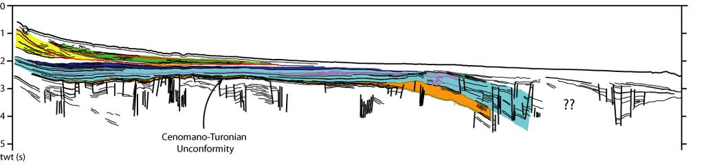
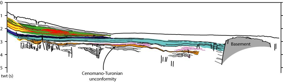
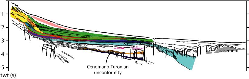
37 DATA KWAZULU - MAPUTALAND MARGIN : OFFSHORE STUDIES KWAZULU MAPUTALAND DURBAN (THEKWINI)
38 DURBAN (THEKWINI) BASIN LITHOLOGY Well-logs Masterlog (reinterpreted from outcrops) BIOSTRATIGRAPHY McMillan (SAPetroleum) NO CLAYS SILTS to VERY FINE SANDS Dolerites Dolerites
39 DURBAN (THEKWINI) BASIN SEDIMENTARY ENVIRONMNENTS Well-logs facies based on outcrop studies Mouth Bars Delta front Shelf Prodelta Fluvial? Shelf Prodelta FLUVIAL-DOMINATED DELTA Mouth Bars Bays Deltaic Plain (Lignite?)
40 DURBAN (THEKWINI) BASIN SEQUENCE STRATIGRAPHY

41 DURBAN (THEKWINI) BASIN: Wells correlation CAMPANIAN CONIACIAN LATE CENOMANIAN APTIAN Basement BARREMIAN Basement

42 DURBAN (THEKWINI) BASIN SEQUENCE STRATIGRAPHY UPLIFT SOUTH AFRICAN PLATEAU Tectonic Eustatic? AFRICA-SCALE
43 KWAZULU-MAPUTALAND BASIN North Durban Maputo South
44 TOP CENOMANIAN UNCONCONFORMITY INCISED CHANNELS BASIN FLOOR FANS


45 TOP CENOMANIAN UNCONCONFORMITY INCISED CHANNELS BASIN FLOOR FANS
46 TOP CENOMANIAN UNCONCONFORMITY INFILLING PROXIMAL LOBES

47 UPPERMOST CRETACEOUS: MAINLY HEMIPELAGITES SMALL CHANNELS DEBRIS FLOWS or SMALL LOBES
48 KWAZULU-MAPUTALAND BASIN North Durban Maputo South
49
Controls on clastic systems in the Angoche basin, Mozambique: tectonics, contourites and petroleum systems
 P2-2-13 Controls on clastic systems in the Angoche basin, Mozambique: tectonics, contourites and petroleum systems Eva Hollebeek, Olivia Osicki, Duplo Kornpihl Schlumberger, London, UK Introduction Offshore
Future giant discovery in the Outeniqua Basin, offshore South Africa. Anongporn Intawong & Neil Hodgson
 Future giant discovery in the Outeniqua Basin, offshore South Africa Anongporn Intawong & Neil Hodgson Spectrum Geoscience 23 February 2017 1 Talk Outlines Structural framework & Evolution of the South
A comparison of structural styles and prospectivity along the Atlantic margin from Senegal to Benin. Peter Conn*, Ian Deighton* & Dario Chisari*
 A comparison of structural styles and prospectivity along the Atlantic margin from Senegal to Benin Overview Peter Conn*, Ian Deighton* & Dario Chisari* * TGS, Millbank House, Surbiton, UK, KT6 6AP The
Perspectives from Offshore Argentina & Uruguay
 Perspectives from Offshore Argentina & Uruguay A Prospectivity Overview Hannah Kearns October 2018 Introduction Argentina Offshore License Round 1 14 blocks Argentina North, 24 Austral-Malvinas Offshore
Geological development of the Durban Basin
 Basin-scale assessment of the potential CO 2 storage of the offshore Durban Basin, KwaZulu-Natal, South Africa Geological development of the Durban Basin N. Hicks (MSc) (PhD Candidate) Senior Scientist
Meandering Miocene Deep Sea Channel Systems Offshore Congo, West Africa
 Meandering Miocene Deep Sea Channel Systems Offshore Congo, West Africa S. Baer* (PGS), J. E. Comstock (PGS), K. Vrålstad (PGS), R. Borsato (PGS), M. Martin (PGS), J.P. Saba (SNPC), B. Débi-Obambé (SNPC)
Effects of Tides on Deltaic Deposition: Causes and Responses*
 Effects of Tides on Deltaic Deposition: Causes and Responses* Piret Plink-Bjorklund 1 Search and Discovery Article #50626 (2012)** Posted June 25, 2012 *Adapted from oral presentation at AAPG Annual Convention
Sequence Stratigraphy. Historical Perspective
 Sequence Stratigraphy Historical Perspective Sequence Stratigraphy Sequence Stratigraphy is the subdivision of sedimentary basin fills into genetic packages bounded by unconformities and their correlative
EGAS. Ministry of Petroleum
 EGAS Ministry of Petroleum EGAS Ministry of Petroleum About The Block Location: N. Thekah offshore block is located at about 56 km to the north of the Mediterranean shore line, 85 km to the north west
The Sierra Leone-Liberia Emerging Deepwater Province*
 The Sierra Leone-Liberia Emerging Deepwater Province* Joan F. Flinch 1, José L. Huedo 1, Hernán Verzi 1, Héctor González 1, Ricardo Gerster 1, Abdul K. Mansaray 1, L. P. Painuly 1, Leticia Rodriguez-Blanco
MUHAMMAD S TAMANNAI, DOUGLAS WINSTONE, IAN DEIGHTON & PETER CONN, TGS Nopec Geological Products and Services, London, United Kingdom
 Geological and Geophysical Evaluation of Offshore Morondava Frontier Basin based on Satellite Gravity, Well and regional 2D Seismic Data Interpretation MUHAMMAD S TAMANNAI, DOUGLAS WINSTONE, IAN DEIGHTON
A Tectonostratigraphic History of Orphan Basin, Offshore Newfoundland, Canada
 A Tectonostratigraphic History of Orphan Basin, Offshore Newfoundland, Canada Lynn T. Dafoe*, Charlotte E. Keen, Graham L. Williams, and Sonya A. Dehler, Geological Survey of Canada, Dartmouth, NS Canada
Accommodation. Tectonics (local to regional) Subsidence Uplift
 Subsidence Uplift") Accommodation Accommodation varies over time; it is the distance between a reference horizon and the sea surface (i.e. relative sea level). The space to be filled in with sediments or water What are the
Accommodation Accommodation varies over time; it is the distance between a reference horizon and the sea surface (i.e. relative sea level). The space to be filled in with sediments or water What are the
EGAS. Ministry of Petroleum
 EGAS Ministry of Petroleum EGAS Ministry of Petroleum About The Block Location: N. El Arish offshore block is located in the extreme eastern part of the Egypt s economic water border and bounded from the
Plaattektoniek en Mickey Mouse: de bewegingen van de Aarde en de geologie van Marokko. G. Bertotti - TUDelft
 Plaattektoniek en Mickey Mouse: de bewegingen van de Aarde en de geologie van Marokko G. Bertotti - TUDelft Moving continents Continent with matching boundaries Same fauna in different continents Similar
OUTCROP! CHARACTERISATION! OF! TRANSGRESSIVE! SANDSTONE! RESERVOIRS:! QUANTITATIVE!COMPARISON!OF!OUTCROP!ANALOGUES!
 OUTCROP CHARACTERISATION OF TRANSGRESSIVE SANDSTONE RESERVOIRS: QUANTITATIVECOMPARISONOFOUTCROPANALOGUES OLIVER D. JORDAN 1, PETER J. SIXSMITH 2, GARY J. HAMPSON, SANJEEV GUPTA & HOWARDD.JOHNSON DepartmentofEarthScienceandEngineering,ImperialCollegeLondon,SouthKensington
The Mesozoic. Wednesday, November 30, 11
 The Mesozoic Periods of the Mesozoic Triassic- First period of the Mesozoic era Jurassic Cretaceous- Last period of the Mesozoic era Breakup of Pangaea Stage one (Triassic) Rifting and volcanism, normal
Sequence stratigraphy and basin analysis of the Meso- to Cenozoic Tarfaya- Laayoune Basins, on- and offshore Morocco
 Sequence stratigraphy and basin analysis of the Meso- to Cenozoic Tarfaya- Laayoune Basins, on- and offshore Morocco INAUGURAL-DISSERTATION zur Erlangung der Doktorwtirde der Naturwissenschaftlich-Mathematischen
Seismic stratigraphy, some examples from Indian Ocean, interpretation of reflection data in interactive mode
 Seismic stratigraphy, some examples from Indian Ocean, interpretation of reflection data in interactive mode K. S. Krishna National Institute of Oceanography, Dona Paula, Goa-403 004. krishna@nio.org Seismic
The Late Tertiary Deep-Water Siliciclastic System of the Levant Margin - An Emerging Play Offshore Israel*
 The Late Tertiary Deep-Water Siliciclastic System of the Levant Margin - An Emerging Play Offshore Israel* Michael A. Gardosh 1, Yehezkel Druckman 2 and Binyamin Buchbinder 2 Search and Discovery Article
Vail et al., 1977b. AAPG 1977 reprinted with permission of the AAPG whose permission is required for further use.
 Well 5 Well 4 Well 3 Well 2 Well 1 Vail et al., 1977b AAPG 1977 reprinted with permission of the AAPG whose permission is required for further use. Well 5 Well 4 Well 3 Well 2 Well 1 Vail et al., 1977b
Case Study of the Structural and Depositional-Evolution Interpretation from Seismic Data*
 Case Study of the Structural and Depositional-Evolution Interpretation from Seismic Data* Yun Ling 1, Xiangyu Guo 1, Jixiang Lin 1, and Desheng Sun 1 Search and Discovery Article #20143 (2012) Posted April
Deepwater Hydrocarbon Potentialof Orange Basin, South Africa: An Untested Oil Play
 Deepwater Hydrocarbon Potentialof Orange Basin, South Africa: An Untested Oil Play Soumen Dasgupta*, Moumita Sengupta, Prem Kumar, Biswanath Ghosh, Dr. BNS Naidu anddr. Sudhir Mathur. Cairn India Limited,
Copyright McGraw-Hill Education. All rights reserved. No reproduction or distribution without the prior written consent of McGraw-Hill Education
 Copyright McGraw-Hill Education. All rights reserved. No reproduction or distribution without the prior written consent of McGraw-Hill Education Tibetan Plateau and Himalaya -southern Asia 11.00.a VE 10X
Aptian/Albian Reservoir Development in the Jeanne d Arc Basin, Offshore Eastern Canada
 Aptian/Albian Reservoir Development in the Jeanne d Arc Basin, Offshore Eastern Canada Jonathan Marshall, Statoil Canada Ltd. Calgary, Alberta, Canada. jomars@statoil.com Introduction: The Jeanne d Arc
Sedimentary Basins. Gerhard Einsele. Springer-Verlag Berlin Heidelberg New York London Paris Tokyo Hong Kong Barcelona Budapest
 Gerhard Einsele Sedimentary Basins Evolution, Facies, and Sediment Budget With 269 Figures Springer-Verlag Berlin Heidelberg New York London Paris Tokyo Hong Kong Barcelona Budapest Contents Part I Types
DATA REPOSITORY MATERIAL: PALEOCHANNEL GROUP MAPPING DESCRIPTIONS
 Data Repository item 2695 DATA REPOSITORY MATERIAL: PALEOCHANNEL GROUP MAPPING DESCRIPTIONS Groups 1 (North Myrtle Beach) and 2 (Atlantic Beach) Channel Groups 1 (North Myrtle Beach) and 2 (Atlantic Beach)
SEDIMENTARY BASINS BASIN TYPES ACCORDING TO TECTONIC. by Prof. Dr. Abbas Mansour
 SEDIMENTARY BASINS BASIN TYPES ACCORDING TO TECTONIC by Prof. Dr. Abbas Mansour B. Convergent plate margins 10. STABLE CONTINENTAL INTERIOR BASIN E.g. Lake Eyre Basin Intracratonic (= within stable continental
Blocks offered in Sri Lanka s Second Licensing Round
 Blocks offered in Sri Lanka s Second Licensing Round Sri Lankan Main Basins Cauvery Basin Cauvery Deep Water sub-basin Mannar Basin 2 Structural Framework Sri Lanka Basins Cauvery & Mannar Basins were
Regional Paleogeography and Implications for Petroleum Prospectivity, Taranaki Basin, New Zealand*
 Regional Paleogeography and Implications for Petroleum Prospectivity, Taranaki Basin, New Zealand* Dominic P. Strogen 1, Kyle J. Bland 1, Jan R. Baur 1,2, and Peter R. King 1 Search and Discovery Article
Application of Predictive Modeling to the Lower Cretaceous Sedimentary Sequences of the Central Scotian Basin
 Application of Predictive Modeling to the Lower Cretaceous Sedimentary Sequences of the Central Scotian Basin Christopher R. Sangster 1, Nicolas Hawie 2, Georgia Pe-Piper 1, Francky Saint-Ange 2, David
Figure 1 Extensional and Transform Fault Interaction, Influence on the Upper Cretaceous Hydrocarbon System, Equatorial Margin, West Africa.
 Figure 1 Extensional and Transform Fault Interaction, Influence on the Upper Cretaceous Hydrocarbon System, Equatorial Margin, West Africa. Presented to the 10th PESGB/HGS Conference on Africa E + P September
East Africa Transform Margin The View from Tanzania and Madagascar
 East Africa Transform Margin The View from Tanzania and Madagascar Richard Higgins and Mark Sofield 10 th PESGB/HGS Conference on African E & P, London, September 7-8, 2011 Acknowledgements Legal Notice:
Supplementary Material for Eighty million years of folding migration: new perspective on the Syrian Arc from Levant basin analysis
 GSA Data Repository 2018040 https://doi.org/10.1130/g39654.1 Supplementary Material for Eighty million years of folding migration: new perspective on the Syrian Arc from Levant basin analysis Sagy Yael,
Continental Landscapes
 Continental Landscapes Landscape influenced by tectonics, climate & differential weathering Most landforms developed within the last 2 million years System moves toward an equilibrium Continental Landscapes
Structural Framework and Deep-Marine Depositional Environments of Miocene- Pleistocene Sequence in Western Offshore Myanmar
 P-58 Structural Framework and Deep-Marine Depositional Environments of Miocene- Pleistocene Sequence in Western Offshore Myanmar Mukesh Jain*, Prabal Shankar Das, Bidesh Bandyopadhyay Summary The western
Rockall Plateau. OCN 201: Shelf Sediments
 Rockall Plateau OCN 201: Shelf Sediments Classification by Size Classification by Mode of Formation Detrital sediments Transported and deposited as particles Derived from weathering of pre-existing rocks
ONSHORE / OFFSHORE & NEW SHALE POTENTIAL OF MOROCCO
 Kingdom of Morocco ONSHORE / OFFSHORE & NEW SHALE POTENTIAL OF MOROCCO Mr M. NAHIM Mrs N. ESSALLOUMI Key aspects of Morocco Political and economic stability; Economic policy of integration at regional
UK Field Training Courses
 UK Field Training Courses Bespoke courses for E&P companies For individual companies and/or partnerships Reservoir and exploration sedimentology oriented Integrated with company sedimentologist if desired
Sedimentation on passive margins. Master1 Géologie de l Exploration et des Réservoirs Dynamique des Bassins Michel Séranne
 Sedimentation on passive margins 1 Tectonic-sedimentation relationships at passive margin scale rift Break-up Young margin Sedimentation is controled by continental margin geodynamic evolution Mature margin
Sedimentary Cycle Best Practice: Potential Eo-Oligocene Sediments in Western Indonesia*
 Sedimentary Cycle Best Practice: Potential Eo-Oligocene Sediments in Western Indonesia* Mellinda Arisandy 1 and I Wayan Darma 1 Search and Discovery Article #11008 (2017)** Posted November 6, 2017 *Adapted
Continental Margin Geology of Korea : Review and constraints on the opening of the East Sea (Japan Sea)
") Continental Margin Geology of Korea : Review and constraints on the opening of the East Sea (Japan Sea) Han-Joon Kim Marine Satellite & Observation Tech. Korea Ocean Research and Development Institute
Continental Margin Geology of Korea : Review and constraints on the opening of the East Sea (Japan Sea) Han-Joon Kim Marine Satellite & Observation Tech. Korea Ocean Research and Development Institute
USU 1360 TECTONICS / PROCESSES
 USU 1360 TECTONICS / PROCESSES Observe the world map and each enlargement Pacific Northwest Tibet South America Japan 03.00.a1 South Atlantic Arabian Peninsula Observe features near the Pacific Northwest
ANGOLA OFFSHORE LICENSING 2007 BLOCK 46
 AGOLA OFFHOR LICIG 2007 BLOCK 46 DATA BA AVAILABILITY Figure 1 shows the seismic data available on Block 46. Fig. 1 Commercial 2D surveys: esterngeco: 794 km. GX Technology: 116 km. Commercial 3D surveys:
DEEP WATER WEST COAST INDIA THE OPENING OF A NEW PLAY BENEATH THE DECCAN BASALTS
 DEEP WATER WEST COAST INDIA THE OPENING OF A NEW PLAY BENEATH THE DECCAN BASALTS Glyn Roberts 1, Charles Harmer 2, Ken Rutherford 3, Colin O Brien 4 1 Consultant, UK; 2 Spectrum Geo, UK; 3 Rutherford Exploration
Pre-Feasibility Report
 Pre-Feasibility Report Project Details: The Block MB-OSN-2005/1 is a Saurashtra shallow water block situated between GS-OSN- 2003/1(NELP-V) in the west, C-37/C-43 PEL in the east and Saurashtra - Dahanu
DEEPWATER WEST COAST INDIA: PRE BASALT AND OTHER MESOZOIC PLAYS
 DEEPWATER WEST COAST INDIA: PRE BASALT AND OTHER MESOZOIC PLAYS Glyn Roberts 1, Charles Harmer 2, Ken Rutherford 3 & Colin O Brien 4 ( 1 Consultant, Spectrum a.s.a, 2 Spectrum a.s.a, 3 Rutherford Exploration
Kilometre-Scale Uplift of the Early Cretaceous Rift Section, Camamu Basin, Offshore North-East Brazil*
 Kilometre-Scale Uplift of the Early Cretaceous Rift Section, Camamu Basin, Offshore North-East Brazil* Iain Scotchman 1 and Dario Chiossi 2 Search and Discovery Article #50183 (2009) Posted May 20, 2009
Abstract. Introduction. Regional Setting. GCSSEPM to be published December 2003
 Shelf Margin Deltas and Associated Deepwater Deposits: Implications on Reservoir Distribution and Hydrocarbon Entrapment, Block VI-1, Ulleung Basin, East Sea, South Korea Sneider, John S. Sneider Exploration,
Tectonics and Hydrocarbon System, East Gobi Basin, Mongolia. Gary Prost, ConocoPhillips Canada, Calgary
 Tectonics and Hydrocarbon System, East Gobi Basin, Mongolia Gary Prost, ConocoPhillips Canada, Calgary Project Objectives (a joint project of Gulf Canada and ROC Oil) What structures can be expected in
RELINQUISHMENT REPORT. License P1546 Block April 2009
 RELINQUISHMENT REPORT License P1546 Block 110-01 14 April 2009 Sherritt International Oil and Gas Limited 2000, 425-1 st street S.W., Calgary, Alberta Canada T2P 3L8 Telephone (403) 260-2900 Fax (403)
Depositional History and Petroleum Potential of Ombilin Basin, West Sumatra - Indonesia, Based on Surface Geological Data*
 Depositional History and Petroleum Potential of Ombilin Basin, West Sumatra - Indonesia, Based on Surface Geological Data* Yahdi Zaim 1, Litto Habrianta 2, Chalid I. Abdullah 1, Aswan 1, Yan Rizal 1, Nurcahyo
BALOCHISTAN FOLDBELT BASIN
 INTRODUCTION BALOCHISTAN FOLDBELT BASIN The Kharan-3 block is located in the Kharan Trough of Balochistan Basin. GEOLOGICAL SETTING The Balochistan Province is an Upper Cretaceous to Recent structurally
Figure 1: Location and bathymetry of the study area. Gulf of Guinea. Cameroon. Congo. Gabon. PGS/DGH Gabon MegaSurvey Coverage (35000Km 2 ) Eq.
 Eq.") Deepwater hydrocarbon prospectivity analysis of offshore North and South Gabon Muhammad S Tamannai (*), Thomas Hansen (1), Ron Borsato (1), Jennifer Greenhalgh (1) Martial-Rufin Moussavou (2) & Landry
Deepwater hydrocarbon prospectivity analysis of offshore North and South Gabon Muhammad S Tamannai (*), Thomas Hansen (1), Ron Borsato (1), Jennifer Greenhalgh (1) Martial-Rufin Moussavou (2) & Landry
Dalhousie University- Petroleum Geoscience Field Methods- Trinidad Summary Report
 Dalhousie University- Petroleum Geoscience Field Methods- Trinidad Summary Report Submitted to: Offshore Energy Research Association of Nova Scotia (OERA) To fulfill requirements of the Undergraduate Student
Quantitative Tarfaya Basin Development, Morocco*
 Quantitative Tarfaya Basin Development, Morocco* Axel Wenke 1, Rainer Zühlke 1, Haddou Jabour 2, Oliver Kluth 3, and Torge Schümann 3 Search and Discovery Article #10420 (2012)** Posted July 16, 2012 *Adapted
2.1. Central Indus Basin:
 14 2.1. Central Indus Basin: Research area lies in the Central Indus Basin of Pakistan. Central Indus Basin may be divided into following broad tectonic divisions from east to west (Kadri, 1995) (1) Punjab
Depositional Environments. Depositional Environments
 Depositional Environments Geographic area in which sediment is deposited Characterized by a combination of geological process & environmental conditions Depositional Environments Geological processes:
Depositional Environments and Hydrocarbon Potential of Northern Ionian Sea
 Depositional Environments and Hydrocarbon Potential of Northern Ionian Sea Vasiliki Kosmidou George Makrodimitras Nick Papatheodorou Contents Area of Interest Studied Dataset Workflow SWIT and Paleolatitude
Seismic interpretation of carbonate turbidites in Central Luconia
 GeoL. Soc. MaLayaia, BuLLetin 47, December 2005; pp. 77-85 Seismic interpretation of carbonate turbidites in Central Luconia FRANcis Ho, GUENTER JAEGER AND PmT LAMBREGTS Sarawak Shell Berhad SMEP Exploration
17. SEISMIC SEQUENCES OF CAPE BOJADOR, NORTHWEST AFRICA
 17. SEISMIC SEQUENCES OF CAPE BOJADOR, NORTHWEST AFRICA K. Hinz, Bundesanstalt fur Geowissenschaften und Rohstoffe. Stilleweg 2, D-3000 Hannover 51, Federal Republic of Germany ABSTRACT In the seismic
Horizontal Well Injector/Producer Pair Platong Field, Pattani Basin, Thailand*
 Horizontal Well Injector/Producer Pair Platong Field, Pattani Basin, Thailand* Abhiphat Pakdeesirote 1, Sonchawan Ackagosol 3, Sarayoot Geena 3, Nualjun Kitvarayut 3, Kenneth Lewis 2, Tom Tran 3, Nancy
Cretaceous USM Reservoir, F-O Gas Field, Offshore South Africa: Sedimentological Factors Affecting Economic Viability*
 Cretaceous USM Reservoir, F-O Gas Field, Offshore South Africa: Sedimentological Factors Affecting Economic Viability* Roger Higgs 1 Search and Discovery Article #20072 (2009) Posted May 20, 2009 *Adapted
Côte d I d Ivoire: Undiscovered Opportunities and voire: New Undiscovered Data in Open Opportunities Blocks and New Data in Open Blocks
 Côte d I d Ivoire: Undiscovered Opportunities and voire: New Undiscovered Data in Open Opportunities Blocks and New Data in Open Blocks Christine Roche, Project Geoscientist; PGS Christine Roche, Project
Fluvial-Estuarine and Deltaic Reservoirs, Shelf Margin Delta and Slope Reservoir Characteristics Philip Sedore 2015
 Fluvial-Estuarine and Deltaic Reservoirs, Shelf Margin Delta and Slope Reservoir Characteristics Philip Sedore 2015 Introduction The offshore Columbus Basin and the onshore Southern Basin of Trinidad are
SUPPLEMENTARY INFORMATION
 SUPPLEMENTARY INFORMATION Miocene drainage reversal of the Amazon River driven by plate-mantle interaction. Shephard, G.E., Müller, R.D., Liu, L., Gurnis, M. Supplementary Figures SOM Figure 1. Non-dimensional
Integrated well log and 3-D seismic data interpretation for the Kakinada area of KG PG offshore basin
 IOSR Journal of Applied Geology and Geophysics (IOSR-JAGG) e-issn: 2321 0990, p-issn: 2321 0982.Volume 5, Issue 4 Ver. II (Jul. Aug. 2017), PP 01-05 www.iosrjournals.org Integrated well log and 3-D seismic
Chapter 17. Ocean and Coastal Processes
 Chapter 17 Ocean and Coastal Processes Ocean Basins and Plates Ocean Basins Ocean Basins are profoundly different from the continents. Ocean crust is thin and dense and young. New ocean crust is generated
Questions and Topics
 Plate Tectonics and Continental Drift Questions and Topics 1. What are the theories of Plate Tectonics and Continental Drift? 2. What is the evidence that Continents move? 3. What are the forces that
Chapter 3. Geology & Tectonics
 Chapter 3 Geology & Tectonics 3.1 Geology The general geological features of Indonesia are shown in Figure 3.1. The basement formation is metamorphic and it is intruded with plutonic formations. They are
Petroleum Geology and Exploration History of the Mergui Basin, THAILAND EPPM (P1) PROJECT
 PROJECT") Petroleum Geology and Exploration History of the Mergui Basin, THAILAND EPPM (P1) PROJECT KRABI, THAILAND 12 th May 2009 Contents of Presentation 1. Exploration History 1. Exploration History 2. General
Petroleum Geology and Exploration History of the Mergui Basin, THAILAND EPPM (P1) PROJECT KRABI, THAILAND 12 th May 2009 Contents of Presentation 1. Exploration History 1. Exploration History 2. General
35th Annual GCSSEPM Foundation Bob F Perkins Research Conference 2016
 35th Annual GCSSEPM Foundation Bob F Perkins Research Conference 2016 Mesozoic of the Gulf Rim and Beyond: New Progress in Science and Exploration of the Gulf of Mexico Basin Houston, Texas, USA 8 9 December
In 1990, 50% of the U.S. population lived within 75 km of a coast. By 2010, 75% of the U.S. population will live within 75 km of a coast.
 In 1990, 50% of the U.S. population lived within 75 km of a coast. By 2010, 75% of the U.S. population will live within 75 km of a coast. High Tech Methods for Surveying the Deep Sea Floor Fig. 20.18 1
The Building of the NYC Region
 The Building of the NYC Region Definitions Fall Line marks the area where an upland region (continental bedrock) and a coastal plain meet Piedmont the plateau region of the eastern United States which
Ocean and Coastal Processes. Ocean Basins. Chapter 20. Ocean Basins and Plates. Ocean Terms. Sea Arch Bay-mouth Bar Spit Tombolo Coast.
 Chapter 20 Ocean Basins and Plates Ocean and Coastal Processes Tide Wave Height Length Period Base Refraction Tsunami Beach Sea stack Ocean Terms Sea Arch Bay-mouth Bar Spit Tombolo Coast Emergent Submergent
Quiz 12 Bonus 2 (9:30-9:35 AM)
") Quiz 12 Bonus 2 (9:30-9:35 AM) UNIVERSITY OF SOUTH ALABAMA GY 112: Earth History Lectures 32 and 33: Mesozoic Sedimentation Instructor: Dr. Douglas W. Haywick Last Time Mesozoic Tectonics A) The Triassic
Quiz 12 Bonus 2 (9:30-9:35 AM) UNIVERSITY OF SOUTH ALABAMA GY 112: Earth History Lectures 32 and 33: Mesozoic Sedimentation Instructor: Dr. Douglas W. Haywick Last Time Mesozoic Tectonics A) The Triassic
Crustal Activity. Plate Tectonics - Plates - Lithosphere - Asthenosphere - Earth s surface consists of a major plates and some minor ones
 Name: Date: Period: Tectonics The Physical Setting: Earth Science CLASS NOTES Tectonics - s - Lithosphere - Asthenosphere - Earth s surface consists of a major plates and some minor ones The plates are
Defining the former elevation and shape of the lithosphere, in particular the elevation of the Earth s surface,
 Isostasy in Move Defining the former elevation and shape of the lithosphere, in particular the elevation of the Earth s surface, is important in the restoration of a model as it aids in reducing uncertainty
Bulletin of Earth Sciences of Thailand
 Quantitative Seismic Geomorphology of Early Miocene to Pleistocene Fluvial System of Northern Songkhla Basin, Gulf of Thailand Oanh Thi Tran Petroleum Geoscience Program, Department of Geology, Faculty
Figure 1. Examples of vector displacement diagrams for two and three-plate systems.
 Figure 1. Examples of vector displacement diagrams for two and three-plate systems. Figure 2. Relationships between pole of rotation, great circles, ridge segments, small circles, transforms and fracture
When last we left off. Western Cordillera NA. Cretaceous. Cretaceous, continued. Cretaceous to present
 When last we left off Western Cordillera NA Cretaceous to present Wild and weird things happened in the murky past of the Archean and precambrian Cambrian through Devonian development of deep water sediments
Marine Cenozoic Record. Precambrian - Jurassic. Uplift. Compton (2004) Thin Cenozoic cover on the margin. Orange Basin. SA Petroleum Agency
 Thin Cenozoic cover on the margin. Orange Basin. SA Petroleum Agency") Marine Cenozoic Record Precambrian - Jurassic A B Uplift Thin Cenozoic cover on the margin Compton (2004) Orange Basin SA Petroleum Agency Eustatic Sea Level (m) 250 200 150 100 50 0 Quat Pliocene AGE
Marine Cenozoic Record Precambrian - Jurassic A B Uplift Thin Cenozoic cover on the margin Compton (2004) Orange Basin SA Petroleum Agency Eustatic Sea Level (m) 250 200 150 100 50 0 Quat Pliocene AGE
Geology of Neoproterozoic to Cambrian Adelaide Geosyncline and Cambrian Delamerian Orogen
 Geology of Neoproterozoic to Cambrian Adelaide Geosyncline and Cambrian Delamerian Orogen W. V. Preiss Geological Survey Branch, PIRSA Link line traverses Flinders Ranges to join western end of E-W Curnamona
Massive Erosion of Other Coastal Great Escarpments
 Appendix 5 Massive Erosion of Other Coastal Great Escarpments Chapter 12 describes the coastal Great Escarpment around southeast South Africa. Other erosional escarpments are found inland from the coasts
Hydrocarbon Exploration of Mesozoic in Kutch Offshore Area
 6 th International Conference & Exposition on Petroleum Geophysics Kolkata 2006 Hydrocarbon Exploration of Mesozoic in Kutch Offshore Area Ram Krishna Singh 1, R.C. Agrawalla 2, D. P. Verma 3, A. K. Goel
FLUVIAL LANDFORMS. Floodplains
 FLUVIAL LANDFORMS Floodplains fairly flat & continuous surface occupying much of a valley bottom normally underlain by unconsolidated sediments subject to periodic flooding (usually once every year or
Orphan Basin, Offshore Newfoundland: New seismic data and hydrocarbon plays for a dormant Frontier Basin
 Orphan Basin, Offshore Newfoundland: New seismic data and hydrocarbon plays for a dormant Frontier Basin Jerry Smee* G&G Exploration Consulting, 301 400-3rd Avenue SW, Calgary, AB, T2P 4H2 Sam Nader, Paul
Beckenanalyse 2. Genetische stratigraphische Konzepte
 Beckenanalyse 2. Genetische stratigraphische Konzepte Einsele 2000 CYCLIC BEDDING Einsele 2000 1 Sequenzstratigraphie Das Konzept der Sequenzstratigraphie beruht auf dem Zusammenspiel von Sedimentzufuhr
3D geological model for a gas-saturated reservoir based on simultaneous deterministic partial stack inversion.
 first break volume 28, June 2010 special topic A New Spring for Geoscience 3D geological model for a gas-saturated reservoir based on simultaneous deterministic partial stack inversion. I. Yakovlev, Y.
Blocks 31, 32, 33, 34, 35 & 36/03 Southeast Offshore Vietnam
 Blocks 31, 32, 33, 34, 35 & 36/03 Southeast Offshore Vietnam Block 31 32 33 34 35 36/03 Area (km 2) 5,036 4,440 4,630 4,700 4,630 2,950 Sea level (m) 20 20-30 30-40 50 50 50 Seismic 2D (km) 1,294 685 431
PETROLEUM GEOLOGY OF THE RUSSIAN FAR-EAST
 Contents - 1 PETROLEUM GEOLOGY OF THE RUSSIAN FAR-EAST CONTENTS PART I: INTRODUCTION TO THE RUSSIAN FAR EAST AND ITS STRUCTURAL DEVELOPMENT. Chapter 1. The Russian Far East: Introduction and Infrastructure.
Spaceborne radar applications in Geology
 216 051 ESATM-17 December 2005 Spaceborne radar applications in Geology An introduction to imaging radar, and application examples of ERS SAR in Geology and Geomorphology European Spate Agency Agente spatiale
Geologic Trips San Francisco and the Bay Area
 Excerpt from Geologic Trips San Francisco and the Bay Area by Ted Konigsmark ISBN 0-9661316-4-9 GeoPress All rights reserved. No part of this book may be reproduced without written permission in writing,
Journal of Earth Sciences and Geotechnical Engineering, vol. 4, no. 1, 2014, ISSN: (print), (online) Scienpress Ltd, 2014
, (online) Scienpress Ltd, 2014") Journal of Earth Sciences and Geotechnical Engineering, vol. 4, no. 1, 2014, 17-24 ISSN: 1792-9040 (print), 1792-9660 (online) Scienpress Ltd, 2014 Reconstruction of Relative Tectonic Movements Using Transgressive
Journal of Earth Sciences and Geotechnical Engineering, vol. 4, no. 1, 2014, 17-24 ISSN: 1792-9040 (print), 1792-9660 (online) Scienpress Ltd, 2014 Reconstruction of Relative Tectonic Movements Using Transgressive
The boundary between two formations (or any distinct layers) is called a contact. Sedimentary rocks cover 75% of continents.
 is called a contact. Sedimentary rocks cover 75% of continents.") Sedimentary Rocks Sedimentary rocks form at the Earth s surface through interactions of the hydrologic system and the crust. Fortunately, many of these processes are in operation today, and geologists
Sedimentary Rocks Sedimentary rocks form at the Earth s surface through interactions of the hydrologic system and the crust. Fortunately, many of these processes are in operation today, and geologists
EARTH SURFACE PROCESSES AND SEDIMENTATION!
 Sed and Strat EARTH SURFACE PROCESSES AND SEDIMENTATION! 2/27 Lecture 7- Exposure: Weathering and the Sediment Factory 3/04 Lecture 8 - Rivers and Landscapes 3/06 Lecture 9 - Waves (not Tides) 3/11 Lecture
3/5/05 Dr. Stewart 1
 I. Physiography of Appalachian Mountains A. Introduction 1. These mountains extend from NE Canada to Georgia 2. They are the remains of a deeply eroded, ancient mountain chain once larger than the Himalayans
Evaluation of Neocomian Shale source rock In Komombo Basin, Upper Egypt
 Evaluation of Neocomian Shale source rock In Komombo Basin, Upper Egypt Abdelhady, A. 1, Darwish, M. 2, El Araby, A. 3 and Hassouba, A. 4 1 DEA Egypt, Cairo, Egypt 2 Geology Department, Faculty of Science,
Sequence Stratigraphy as a tool for water resources management in alluvial coastal aquifers: application to the Llobregat delta (Barcelona, Spain)
") Sequence Stratigraphy as a tool for water resources management in alluvial coastal aquifers: application to the Llobregat delta (Barcelona, Spain) Desiré Gàmez Torrent December 2007 CHAPTER 1: Introduction
Sequence Stratigraphy as a tool for water resources management in alluvial coastal aquifers: application to the Llobregat delta (Barcelona, Spain) Desiré Gàmez Torrent December 2007 CHAPTER 1: Introduction
Rocks and the Rock Cycle. Banded Iron Formation
 Rocks and the Rock Cycle Banded Iron Formation Rocks Big rocks into pebbles, Pebbles into sand. I really hold a million, million Rocks here in my hand. Florence Parry Heide How do rocks change? How are