Depositional Environments and Hydrocarbon Potential of Northern Ionian Sea
|
|
|
- Martha Easter Fisher
- 6 years ago
- Views:
Transcription
1 Depositional Environments and Hydrocarbon Potential of Northern Ionian Sea Vasiliki Kosmidou George Makrodimitras Nick Papatheodorou
2 Contents Area of Interest Studied Dataset Workflow SWIT and Paleolatitude Heat flow BHT and Vitrinite Reflectance Data Geochemical Data Erosion, Uplift and Flexural Rigidity 3D model Paleoenvironments Conclusions


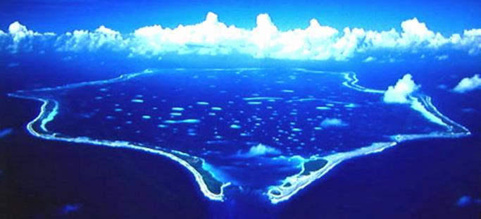
3 Area of Interest Northern Ionian sea is the greater area of western Corfu and Paxos islands in Offshore Western Greece. Geologically, the area is bounded to the north by the Otranto Basin and to the south by the Kefalonia strike-slip fault. On the west there is the Apulian escarpment and from there westwards starts the Calabrian Ridge. On the east, there is the deep basinal area, the South Adriatic Basin, that is bounded on its eastern margin by the front of the Hellenides thrust-and-fold belt. The central part of the basin is the Apulian platform. Apulian Platform
 2D multiclient seismic survey (2012, PGS) Legacy")

4 Studied Dataset 6000km 2D seismic data (approx.) 2D multiclient seismic survey (2012, PGS) Legacy seismic surveys Yannadhes Paxi Gaios 1X Paxi 1 4 wells Paxi-Gaios 1X Paxi 1 East Erikousa 1 Yannadhes 1
.")
5 Workflow SURFACE GRIDS Interpret key horizons in TWT. Depth conversion using sonic data. MODEL Depth converted horizon grids used in a 3D model with Haq's (1987) * sea level curves. Tectonic uplift, subsidence and sediment compaction were not modelled. * Modified by Miller, 2005 THERMAL PARAMETERS Sediment water interface temperature diagram from Wygrala (1989). Paleolatitude for Ionian Sea based on Torsvik et al. (2012). Heat flow scenario based on analogue cases and reference studies. Calibration data available from the AOI. EROSION, UPLIFT AND FLEXURAL RIGIDITY Erosion identification in seismic. Uplift scenario from literature. Flexural rigidity of Nm (Allen & Allen, 2013) ORGANIC GEOCHEMISTRY Rock eval data from AGIP Rock - Eval Report for Paxi-Gaios 1X samples for Kerogen Type categorisation and source rock quality estimation
 5-10 o C <5 o C 10-15 o C 15-20")

6 Latitude( o ) SWIT and latitude changes Time(Ma) 5-10 o C <5 o C o C o C o C o C o C >30 o C North Ionian Sea Modified from Wygrala (1989)
7 Heat flow scenario

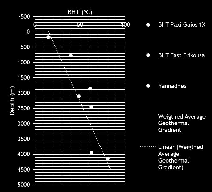
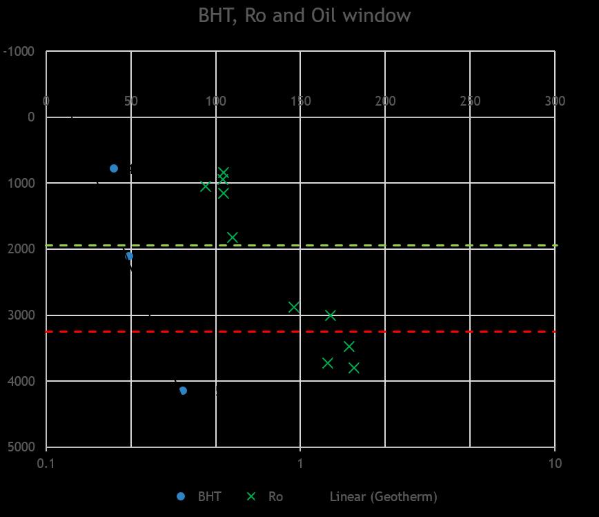
8 BHT and Vitrinite Reflectance Data
9 Very Little SR or no SR Gas SR Gas SR?
.")


10 Erosion 500 m Seismic data suggest important erosional unconformities in the AOI. : Three intra-carbonate erosional unconformities (also observed in Italian outcrops). In the basinal areas unconformities are observed due to the introduction of calciturbidites in the basin. : Three main erosional unconformities in the Miocene sequence with the later and more important one the messinian unconformity. : Three Mass Transport Complexes associated with earthquake and thrust activity. Pliocene-Pleistocene MTC Miocene unconformities Cretaceous intra-carbonate unconformities

11 Uplift and Flexural Rigidity Uplift Flexural Rigidity o Uplift started in middle Pleistocene (Doglioni et al., 1994) associated with the deposition of two loads on the margins of Apulia. This, together with the KTF and isostasy, affected the geometry, tension and pressure profile of the AOI. o o o Allen & Allen (2013) suggest a displacement of the fore bulge towards Apennines by asymmetry of flexural rigidity of Adriatic. Hellenides D= Nm Apennines D= 6 * Nm o In the Middle Pleistocene, the platform was uplifted while the adjacent basinal areas were affected by subsidence (Mastronuzzi et al. 2011). o The maximum deflection is assumed w 0 =10km o Uplift rates from 0.4 to 0.2 ( ) mm/yr (Cianrafi et al. 1988; Doglioni et al., 1994). (From Allen & Allen, 3 rd, 2013)
12 Triassic Terrestrial to shallow marine environment? Neotethys A-B


13 Triassic High Slopes indicative of Rifting Restricted basinal, marine environment adjacent to the carbonate platforms where we expect the deposition of formations equivalent to Burano Fm. C-D
14 Jurassic
15 Jurassic
16 Jurassic
17 Jurassic
18 Jurassic Extensive platform A-B Topographic highs that favour the development of Build Ups

19 Jurassic Rimmed Platform C-D
20 Early Cretaceous
21 Early Cretaceous
22 Early Cretaceous
23 Early Cretaceous Isolated build-ups A-B

24 Early Cretaceous Extensive platform Isolated build-ups C-D
25 Late Cretaceous
26 Late Cretaceous
27 Late Cretaceous Carbonate Build-Ups covered by pelagic sediments
28 Late Cretaceous Subaerial erosion of the carbonate platform led to the development of calciturbidites transferred into the basin impeding the carbonate build up development A-B
29 Late Cretaceous Steep platform slope and intense erosion leads to redeposited carbonate sediments in the slope and proximal basin C-D
30 Paleogene Prograding sediment infill from the east/ thrust propagading
31 Paleogene Prograding sediment infill from the east/ thrust propagading
32 Paleogene Prograding sediment infill from the east/ thrust propagading
33 Paleogene Prograding sediment infill from the east/ thrust propagading
34 Paleogene Prograding sediment infill from the east/ thrust propagading
35 Miocene Prograding sediment infill from the east/ thrust propagading
36 Messinian Highest slopes at the eastern margin match the seismic interpretation suggesting higher sediment infill from the east
37 Messinian Messinian Salinity Crisis Sea Level Drop
38 Messinian Messinian Salinity Crisis Sea Level Drop
39 Messinian Messinian Salinity Crisis Sea Level Drop
40 Messinian Messinian Salinity Crisis Sea Level Drop
41 Messinian Messinian Salinity Crisis Sea Level Drop
42 Messinian Messinian Salinity Crisis Sea Level Drop
43 Messinian Zanclean Flooding
44 Messinian Zanclean Flooding
45 Messinian Zanclean Flooding
46 Messinian Zanclean Flooding
47 Messinian Zanclean Flooding
48 Messinian Zanclean Flooding
49 Messinian Highest slopes at the eastern margin match the seismic interpretation suggesting higher sediment infill from the east A-B


50 Messinian Highest slopes at the eastern margin match the seismic interpretation suggesting higher sediment infill from the east C-D
51 Plio - Pleistocene Excessive deepening due to the KTF and the Uplift
52 Plio - Pleistocene Excessive deepening due to the KTF and the Uplift
53 Plio - Pleistocene Excessive deepening due to the KTF and the Uplift
54 Plio - Pleistocene Excessive deepening due to the KTF and the Uplift
55 Plio - Pleistocene Excessive deepening due to the KTF and the Uplift
56 Plio - Pleistocene Excessive deepening due to the KTF and the Uplift A-B

57 Plio - Pleistocene C-D
58 Lateral Migration of the basin depocenter from Jurassic to Present (C-D)

59 Paleoenvironments
60 Conclusions North Ionian Sea is characterized by a wide shallow water platform with occasionally steep slopes to the west and a deep basin to the east In the basinal part, three isolated carbonate build ups can be identified in the 2D seismic Rock-Eval data suggest good to excellent source rocks Paleothermal data suggest necessary conditions for the maturation of hydrocarbons in the past 3D model allowed the identification of high slope areas indicating the best locations for the development of bioclastic slope aprons and the location of carbonate build-ups 3D model helped the understanding of the lateral change of the basin depocenter due to the thrust activity


61 Questions?
Greece offers new offshore exploration opportunities
 Greece offers new offshore exploration opportunities Kostis Oikonomopoulos George Makrodimitras Yannis Bassias Hellenic Hydrocarbon Resources Management SA Athens, Greece GREECE S OFFSHORE TENDER FIG.
Neogene Uplift of The Barents Sea
 Neogene Uplift of The Barents Sea W. Fjeldskaar A. Amantov Tectonor/UiS, Stavanger, Norway FORCE seminar April 4, 2013 The project (2010-2012) Funding companies Flat Objective The objective of the work
Meandering Miocene Deep Sea Channel Systems Offshore Congo, West Africa
 Meandering Miocene Deep Sea Channel Systems Offshore Congo, West Africa S. Baer* (PGS), J. E. Comstock (PGS), K. Vrålstad (PGS), R. Borsato (PGS), M. Martin (PGS), J.P. Saba (SNPC), B. Débi-Obambé (SNPC)
BALOCHISTAN FOLDBELT BASIN
 INTRODUCTION BALOCHISTAN FOLDBELT BASIN The Kharan-3 block is located in the Kharan Trough of Balochistan Basin. GEOLOGICAL SETTING The Balochistan Province is an Upper Cretaceous to Recent structurally
Sequence Stratigraphy. Historical Perspective
 Sequence Stratigraphy Historical Perspective Sequence Stratigraphy Sequence Stratigraphy is the subdivision of sedimentary basin fills into genetic packages bounded by unconformities and their correlative
Hints of active deformation in the southern Adriatic foreland: Holocene tectonics along the Apulia offshore (Italy)
") Hints of active deformation in the southern Adriatic foreland: Holocene tectonics along the Apulia offshore (Italy) Domenico Ridente^, Umberto Fracassi*, Daniela Di Bucci, Fabio Trincardi^ ^ & Gianluca
Hints of active deformation in the southern Adriatic foreland: Holocene tectonics along the Apulia offshore (Italy) Domenico Ridente^, Umberto Fracassi*, Daniela Di Bucci, Fabio Trincardi^ ^ & Gianluca
EGAS. Ministry of Petroleum
 EGAS Ministry of Petroleum EGAS Ministry of Petroleum About The Block Location: N. Thekah offshore block is located at about 56 km to the north of the Mediterranean shore line, 85 km to the north west
Triassic of the Barents Sea shelf: depositional environments and hydrocarbon potential. Daria A. Norina 1,2
 Triassic of the Barents Sea shelf: depositional environments and hydrocarbon potential Daria A. Norina 1,2 1 TOTAL (Paris, France) 2 The work is a part of PhD thesis conducted in Petroleum Department,
EGAS. Ministry of Petroleum
 EGAS Ministry of Petroleum EGAS Ministry of Petroleum About The Block Location: N. El Arish offshore block is located in the extreme eastern part of the Egypt s economic water border and bounded from the
South Pyrenean foreland basin
 South Pyrenean foreland basin 1 7 South Pyrenean foreland basin 1 8 South-Pyrenean Foreland basin S N Fore-bulge deformation Piggy-back B. Thrust nappes Basement Vergés & al, 2002 decollement Syntectonic
Seismic interpretation of carbonate turbidites in Central Luconia
 GeoL. Soc. MaLayaia, BuLLetin 47, December 2005; pp. 77-85 Seismic interpretation of carbonate turbidites in Central Luconia FRANcis Ho, GUENTER JAEGER AND PmT LAMBREGTS Sarawak Shell Berhad SMEP Exploration
Basin Analysis. Stra-graphy
 Basin Analysis Stra-graphy Basin Analysis Basin analysis integrates program sedimentological, stra-graphic, and tectonic principals to develop a full understanding of the rocks that fill sedimentary basins.
Continental Landscapes
 Continental Landscapes Landscape influenced by tectonics, climate & differential weathering Most landforms developed within the last 2 million years System moves toward an equilibrium Continental Landscapes
Supplementary Material for Eighty million years of folding migration: new perspective on the Syrian Arc from Levant basin analysis
 GSA Data Repository 2018040 https://doi.org/10.1130/g39654.1 Supplementary Material for Eighty million years of folding migration: new perspective on the Syrian Arc from Levant basin analysis Sagy Yael,
Sequence stratigraphy and basin analysis of the Meso- to Cenozoic Tarfaya- Laayoune Basins, on- and offshore Morocco
 Sequence stratigraphy and basin analysis of the Meso- to Cenozoic Tarfaya- Laayoune Basins, on- and offshore Morocco INAUGURAL-DISSERTATION zur Erlangung der Doktorwtirde der Naturwissenschaftlich-Mathematischen
Depositional History and Petroleum Potential of Ombilin Basin, West Sumatra - Indonesia, Based on Surface Geological Data*
 Depositional History and Petroleum Potential of Ombilin Basin, West Sumatra - Indonesia, Based on Surface Geological Data* Yahdi Zaim 1, Litto Habrianta 2, Chalid I. Abdullah 1, Aswan 1, Yan Rizal 1, Nurcahyo
Figure 1 Extensional and Transform Fault Interaction, Influence on the Upper Cretaceous Hydrocarbon System, Equatorial Margin, West Africa.
 Figure 1 Extensional and Transform Fault Interaction, Influence on the Upper Cretaceous Hydrocarbon System, Equatorial Margin, West Africa. Presented to the 10th PESGB/HGS Conference on Africa E + P September
Longitude (E) Depth (m)
 Depth (m)") Table 1. Leg 194 proposed sites. Site Priority Line CDP Fig. Latitude (S) Longitude (E) Water Sediment Target Requested PPSP Depth (m) Thickness (m) Depth (m) Penetration (m) Approval CS-01A 1 MAR-29 4486
Table 1. Leg 194 proposed sites. Site Priority Line CDP Fig. Latitude (S) Longitude (E) Water Sediment Target Requested PPSP Depth (m) Thickness (m) Depth (m) Penetration (m) Approval CS-01A 1 MAR-29 4486
Tetsuya Fujii. Bachelor of Geology, Shinshu University, Japan Master of Geophysics, the University of Tokyo, Japan
 USING 2D AND 3D BASIN MODELLING AND SEISMIC SEEPAGE INDICATORS TO INVESTIGATE CONTROLS ON HYDROCARBON MIGRATION AND ACCUMULATION IN THE VULCAN SUB-BASIN, TIMOR SEA, NORTH-WESTERN AUSTRALIA By Tetsuya Fujii
Israel: Seeing Deeper Imaging new play concepts with Clari-Fi broadband reprocessing
 Israel: Seeing Deeper Imaging new play concepts with Clari-Fi broadband reprocessing Alex Birch-Hawkins Interpretation Geophysicist 12 th December 2016 Contents TGS in Israel Geological Overview Exploration
Controls on clastic systems in the Angoche basin, Mozambique: tectonics, contourites and petroleum systems
 P2-2-13 Controls on clastic systems in the Angoche basin, Mozambique: tectonics, contourites and petroleum systems Eva Hollebeek, Olivia Osicki, Duplo Kornpihl Schlumberger, London, UK Introduction Offshore
Abstract. Introduction. Regional Setting. GCSSEPM to be published December 2003
 Shelf Margin Deltas and Associated Deepwater Deposits: Implications on Reservoir Distribution and Hydrocarbon Entrapment, Block VI-1, Ulleung Basin, East Sea, South Korea Sneider, John S. Sneider Exploration,
VHR seismic imaging of displacement along an active off-shore fault system of the Adriatic foreland
 VHR seismic imaging of displacement along an active off-shore fault system of the Adriatic foreland Daniela Di Bucci 1, Domenico Ridente 2, 3, Umberto Fracassi 4, Fabio Trincardi 2, Gianluca Valensise
Copyright McGraw-Hill Education. All rights reserved. No reproduction or distribution without the prior written consent of McGraw-Hill Education
 Copyright McGraw-Hill Education. All rights reserved. No reproduction or distribution without the prior written consent of McGraw-Hill Education Tibetan Plateau and Himalaya -southern Asia 11.00.a VE 10X
A comparison of structural styles and prospectivity along the Atlantic margin from Senegal to Benin. Peter Conn*, Ian Deighton* & Dario Chisari*
 A comparison of structural styles and prospectivity along the Atlantic margin from Senegal to Benin Overview Peter Conn*, Ian Deighton* & Dario Chisari* * TGS, Millbank House, Surbiton, UK, KT6 6AP The
GLY 155 Introduction to Physical Geology, W. Altermann. Press & Siever, compressive forces. Compressive forces cause folding and faulting.
 Press & Siever, 1995 compressive forces Compressive forces cause folding and faulting. faults 1 Uplift is followed by erosion, which creates new horizontal surface. lava flows Volcanic eruptions cover
2.1. Central Indus Basin:
 14 2.1. Central Indus Basin: Research area lies in the Central Indus Basin of Pakistan. Central Indus Basin may be divided into following broad tectonic divisions from east to west (Kadri, 1995) (1) Punjab
Petroleum Potential of the Application Area L12-4
 Petroleum Potential of the Application Area L12-4 The Application Area (L12-4) is underlain by the western Officer Basin, beneath the Gunbarrel Basin. The general basin architecture is outlined in Figure
Geologic Trips San Francisco and the Bay Area
 Excerpt from Geologic Trips San Francisco and the Bay Area by Ted Konigsmark ISBN 0-9661316-4-9 GeoPress All rights reserved. No part of this book may be reproduced without written permission in writing,
ANGOLA OFFSHORE LICENSING 2007 BLOCK 46
 AGOLA OFFHOR LICIG 2007 BLOCK 46 DATA BA AVAILABILITY Figure 1 shows the seismic data available on Block 46. Fig. 1 Commercial 2D surveys: esterngeco: 794 km. GX Technology: 116 km. Commercial 3D surveys:
Ny bassengmodellering for Barentshavet Ute Mann SINTEF Petroleumsforskning
 Ny bassengmodellering for Barentshavet Ute Mann SINTEF Petroleumsforskning www.og21.no Barents Sea - Challenges 7 different play types Carboniferous Tertiary Uplift and erosion Tilting, reactivation of
Blocks 31, 32, 33, 34, 35 & 36/03 Southeast Offshore Vietnam
 Blocks 31, 32, 33, 34, 35 & 36/03 Southeast Offshore Vietnam Block 31 32 33 34 35 36/03 Area (km 2) 5,036 4,440 4,630 4,700 4,630 2,950 Sea level (m) 20 20-30 30-40 50 50 50 Seismic 2D (km) 1,294 685 431
Quantitative Tarfaya Basin Development, Morocco*
 Quantitative Tarfaya Basin Development, Morocco* Axel Wenke 1, Rainer Zühlke 1, Haddou Jabour 2, Oliver Kluth 3, and Torge Schümann 3 Search and Discovery Article #10420 (2012)** Posted July 16, 2012 *Adapted
Maturity Modeling of Gomin and South Gomin fields Southern Pattani Basin, Gulf of Thailand
 Maturity Modeling of Gomin and South Gomin fields Southern Pattani Basin, Gulf of Thailand Patinya Jaithan Petroleum Geoscience Program, Department of Geology, Faculty of Science, Chulalongkorn University,
The 3-D Seismic Geomorphology of Deep-Water Slope Channel Systems A Case Study from the Deep Water Nile Delta
 Geological Society of Trinidad & Tobago The 3-D Seismic Geomorphology of Deep-Water Slope Channel Systems A Case Study from the Deep Water Nile Delta Nigel E. Cross Presentation Outline Introduction Deep
Southern Songkhla Basin, Gulf of Thailand
 Architecture and Depositional Environment of Fluvial Systems of Southern Songkhla Basin, Gulf of Thailand Toan Manh Do Petroleum Geoscience Program, Department of Geology, Faculty of Science, Chulalongkorn
Geological Evolution of Bago-Yoma Basin, Onshore Myanmar*
 Geological Evolution of Bago-Yoma Basin, Onshore Myanmar* Seehapol Utitsan 1, Teekayu Benjawan 1, Suppakarn Thanatit 1, Wirote Wetmongkongorn 1, U. Soe Than 2, Khun Hline Myint 1, and Ler Bwe Wah 1 Search
Introduction to sequence stratigraphy and its application to reservoir geology
 Introduction to sequence stratigraphy and its application to reservoir geology Massimo Zecchin Istituto Nazionale di Oceanografia e di Geofisica Sperimentale - OGS Historical development Definitions Systems
Ministry of Oil and Minerals Petroleum Exploration & Production Authority BLOCK 85 (Al Uqlah North)
") Ministry of Oil and Minerals Petroleum Exploration & Production Authority BLOCK 85 (Al Uqlah North) The Al Uqlah North Block (85) occupies an area of 597 km 2 in the Sabatayn Basin in the province of Shabwah
Ministry of Oil and Minerals Petroleum Exploration & Production Authority BLOCK 85 (Al Uqlah North) The Al Uqlah North Block (85) occupies an area of 597 km 2 in the Sabatayn Basin in the province of Shabwah
F.H. NADER 1, PETROLEUM SYSTEMS MODELING CHALLENGES OF STRUCTURALLY COMPLEX FRONTIER BASINS: THE CASE OF THE LEVANT (EAST-MED) BASIN
 BASIN") PETROLEUM SYSTEMS MODELING CHALLENGES OF STRUCTURALLY COMPLEX FRONTIER BASINS: THE CASE OF THE LEVANT (EAST-MED) BASIN A PROPOSED INTEGRATED APPROACH F.H. NADER 1, J. Barabasch 2, L. Inati 1, M. Ducros
PETROLEUM SYSTEMS MODELING CHALLENGES OF STRUCTURALLY COMPLEX FRONTIER BASINS: THE CASE OF THE LEVANT (EAST-MED) BASIN A PROPOSED INTEGRATED APPROACH F.H. NADER 1, J. Barabasch 2, L. Inati 1, M. Ducros
Aptian/Albian Reservoir Development in the Jeanne d Arc Basin, Offshore Eastern Canada
 Aptian/Albian Reservoir Development in the Jeanne d Arc Basin, Offshore Eastern Canada Jonathan Marshall, Statoil Canada Ltd. Calgary, Alberta, Canada. jomars@statoil.com Introduction: The Jeanne d Arc
Structural Modelling of Inversion Structures: A case study on South Cambay Basin
 10 th Biennial International Conference & Exposition P 065 Structural Modelling of Inversion Structures: A case study on South Cambay Basin Dr. Mayadhar Sahoo & S.K Chakrabarti Summary The inversion in
Tectonics and Hydrocarbon System, East Gobi Basin, Mongolia. Gary Prost, ConocoPhillips Canada, Calgary
 Tectonics and Hydrocarbon System, East Gobi Basin, Mongolia Gary Prost, ConocoPhillips Canada, Calgary Project Objectives (a joint project of Gulf Canada and ROC Oil) What structures can be expected in
Chapter 3. Geology & Tectonics
 Chapter 3 Geology & Tectonics 3.1 Geology The general geological features of Indonesia are shown in Figure 3.1. The basement formation is metamorphic and it is intruded with plutonic formations. They are
MUHAMMAD S TAMANNAI, DOUGLAS WINSTONE, IAN DEIGHTON & PETER CONN, TGS Nopec Geological Products and Services, London, United Kingdom
 Geological and Geophysical Evaluation of Offshore Morondava Frontier Basin based on Satellite Gravity, Well and regional 2D Seismic Data Interpretation MUHAMMAD S TAMANNAI, DOUGLAS WINSTONE, IAN DEIGHTON
 Sedimentary Basin Analysis http://eqsun.geo.arizona.edu/geo5xx/geos517/ Sedimentary basins can be classified based on the type of plate motions (divergent, convergent), type of the lithosphere, distance
SUPPLEMENTARY INFORMATION
 SUPPLEMENTARY INFORMATION Miocene drainage reversal of the Amazon River driven by plate-mantle interaction. Shephard, G.E., Müller, R.D., Liu, L., Gurnis, M. Supplementary Figures SOM Figure 1. Non-dimensional
Ministry of Oil and Minerals Petroleum Exploration & Production Authority BLOCK 6 (Iryam)
") Ministry of Oil and Minerals Petroleum Exploration & Production Authority BLOCK 6 (Iryam) The Iryam Block (6) occupies an area of 3,911 km 2 in the Sabatayn Basin in the province of Shabwah in central
Ministry of Oil and Minerals Petroleum Exploration & Production Authority BLOCK 6 (Iryam) The Iryam Block (6) occupies an area of 3,911 km 2 in the Sabatayn Basin in the province of Shabwah in central
Comment on: Cenozoic evolution of the eastern Danish North Sea by M. Huuse, H. Lykke-Andersen and O. Michelsen, [Marine Geology 177, 243^269]
![Comment on: Cenozoic evolution of the eastern Danish North Sea by M. Huuse, H. Lykke-Andersen and O. Michelsen, [Marine Geology 177, 243^269]](/thumbs/93/112023617.jpg "Comment on: Cenozoic evolution of the eastern Danish North Sea by M. Huuse, H. Lykke-Andersen and O. Michelsen, [Marine Geology 177, 243^269]") Marine Geology 186 (2002) 571^575 Discussion Comment on: Cenozoic evolution of the eastern Danish North Sea by M. Huuse, H. Lykke-Andersen and O. Michelsen, [Marine Geology 177, 243^269] P. Japsen, T.
Marine Geology 186 (2002) 571^575 Discussion Comment on: Cenozoic evolution of the eastern Danish North Sea by M. Huuse, H. Lykke-Andersen and O. Michelsen, [Marine Geology 177, 243^269] P. Japsen, T.
EDIMENTARY BASINS. What is a Sedimentary Basin? by Prof. Dr. Abbas Mansour
 EDIMENTARY BASINS What is a Sedimentary Basin? by Prof. Dr. Abbas Mansour WHAT IS A SEDIMENTARY BASIN? A low area on the Earth s surface relative to surroundings e.g. deep ocean basin (5-10 km deep) e.g.
MISSISSIPPI RIVER DELTA OVERVIEW
 MISSISSIPPI RIVER DELTA OVERVIEW Science and Engineering Special Team Conference Louisiana State University October 9, 2012 Introduction Basics of the Mississippi Delta Natural and Human-Induced Land Loss
Kilometre-Scale Uplift of the Early Cretaceous Rift Section, Camamu Basin, Offshore North-East Brazil*
 Kilometre-Scale Uplift of the Early Cretaceous Rift Section, Camamu Basin, Offshore North-East Brazil* Iain Scotchman 1 and Dario Chiossi 2 Search and Discovery Article #50183 (2009) Posted May 20, 2009
Ministry of Oil and Minerals Petroleum Exploration & Production Authority BLOCK 80 (WADI SARR)
") Ministry of Oil and Minerals Petroleum Exploration & Production Authority BLOCK 80 (WADI SARR) The Wadi Sarr Block (80) occupies an area of 1961 km 2 on the Sayun- Masilah Basin in the central Yemen. Block
Ministry of Oil and Minerals Petroleum Exploration & Production Authority BLOCK 80 (WADI SARR) The Wadi Sarr Block (80) occupies an area of 1961 km 2 on the Sayun- Masilah Basin in the central Yemen. Block
Earth Science, (Tarbuck/Lutgens) Chapter 10: Mountain Building
 Chapter 10: Mountain Building") Earth Science, (Tarbuck/Lutgens) Chapter 10: Mountain Building 1) A(n) fault has little or no vertical movements of the two blocks. A) stick slip B) oblique slip C) strike slip D) dip slip 2) In a(n) fault,
Earth Science, (Tarbuck/Lutgens) Chapter 10: Mountain Building 1) A(n) fault has little or no vertical movements of the two blocks. A) stick slip B) oblique slip C) strike slip D) dip slip 2) In a(n) fault,
Karl Mueller QUATERNARY RIFT FLANK UPLIFT OF THE PENINSULAR RANGES IN BAJA AND SOUTHERN CALIFORNIA BY REMOVAL OF MANTLE LITHOSPHERE
 QUATERNARY RIFT FLANK UPLIFT OF THE PENINSULAR RANGES IN BAJA AND SOUTHERN CALIFORNIA BY REMOVAL OF MANTLE LITHOSPHERE August 2013 Quaternary Rift Flank Uplift of the Peninsular Ranges in Baja and Southern
Plate Tectonics. entirely rock both and rock
 Plate Tectonics I. Tectonics A. Tectonic Forces are forces generated from within Earth causing rock to become. B. 1. The study of the origin and arrangement of Earth surface including mountain belts, continents,
The Late Tertiary Deep-Water Siliciclastic System of the Levant Margin - An Emerging Play Offshore Israel*
 The Late Tertiary Deep-Water Siliciclastic System of the Levant Margin - An Emerging Play Offshore Israel* Michael A. Gardosh 1, Yehezkel Druckman 2 and Binyamin Buchbinder 2 Search and Discovery Article
Vail et al., 1977b. AAPG 1977 reprinted with permission of the AAPG whose permission is required for further use.
 Well 5 Well 4 Well 3 Well 2 Well 1 Vail et al., 1977b AAPG 1977 reprinted with permission of the AAPG whose permission is required for further use. Well 5 Well 4 Well 3 Well 2 Well 1 Vail et al., 1977b
PROCEEDINGS, INDONESIAN PETROLEUM ASSOCIATION Fortieth Annual Convention & Exhibition, May 2016
 IPA16-546-G PROCEEDINGS, INDONESIAN PETROLEUM ASSOCIATION Fortieth Annual Convention & Exhibition, May 2016 BASIN AND PETROLEUM SYSTEM MODELING OF OFFSHORE TANIMBAR REGION: IMPLICATIONS OF STRUCTURAL DEVELOPMENT
SEDIMENTARY BASINS Red Sea Coast of Egypt. by Prof. Dr. Abbas Mansour
 SEDIMENTARY BASINS Red Sea Coast of Egypt by Prof. Dr. Abbas Mansour Sedimentary basins Sedimentary basins are, in a very broad sense, all those areas in which sediments can accumulate to considerable
Ionian Sea and Margins: Recent Prospections and Interpretations
 Ionian Sea and Margins: Recent Prospections and Interpretations Liliana Minelli co-authors: Faccenna C., Casero P. Dipartimento Scienze Geologiche Università Roma Tre 9th Offshore Mediterranean Conference
Petroleum geology framework, West Coast offshore region
 Petroleum geology framework, West Coast offshore region James W. Haggart* Geological Survey of Canada, Vancouver, BC jhaggart@nrcan.gc.ca James R. Dietrich Geological Survey of Canada, Calgary, AB and
4. Basins due to orogenic loading
 4. Basins due to orogenic loading Orogenic loading and lithospheric flexure: peripheral vs. retroarc foreland basin Elastic vs. viscoelastic models Gravity anomalies, foreland flexure, and the development
Sierro F.J. 1, Ledesma S. 2 and Flores J.A. 1
 Astrobiochronology of Late Neogene deposits near the Strait of Gibraltar (SW Spain). Implications for the tectonic control of the Messinian Salinity Crisis. Sierro F.J. 1, Ledesma S. 2 and Flores J.A.
Bulletin of Earth Sciences of Thailand
 Quantitative Seismic Geomorphology of Early Miocene to Pleistocene Fluvial System of Northern Songkhla Basin, Gulf of Thailand Oanh Thi Tran Petroleum Geoscience Program, Department of Geology, Faculty
Fourth Energy Summit Sustainable, competitive and secure energy in Europe. Avraam Zelilidis, Professor Department of Geology, University of Patras
 Fourth Energy Summit Sustainable, competitive and secure energy in Europe Monday 14 th November 2011, Nicosia Cyprus The status of energy exploration in Cyprus and its geostrategic significance for the
Defining the former elevation and shape of the lithosphere, in particular the elevation of the Earth s surface,
 Isostasy in Move Defining the former elevation and shape of the lithosphere, in particular the elevation of the Earth s surface, is important in the restoration of a model as it aids in reducing uncertainty
Geochemical Appraisal using Vitrinite Reflectance and Rock-Eval Data, of Shishtu and Sardar Formations Central Iran
 Geochemical Appraisal using Vitrinite Reflectance and Rock-Eval Data, of Shishtu and Sardar Formations Central Iran Jahangard. A. A, Alizadeh. B, Hosseini. S. H. Department of Geology, Faculty of Earth
North GOM Petroleum Systems: Modeling the Burial and Thermal History, Organic Maturation, and Hydrocarbon Generation and Expulsion
 North GOM Petroleum Systems: Modeling the Burial and Thermal History, Organic Maturation, and Hydrocarbon Generation and Expulsion Roger J. Barnaby 2006 GCAGS MEETING Previous studies of northern GOM crude
The Mesozoic. Wednesday, November 30, 11
 The Mesozoic Periods of the Mesozoic Triassic- First period of the Mesozoic era Jurassic Cretaceous- Last period of the Mesozoic era Breakup of Pangaea Stage one (Triassic) Rifting and volcanism, normal
PLATEAU UPLIFT, EPEIROGENEY AND CLIMATE CHANGES The KALAHARI PLATEAU, a world class laboratory
 PLATEAU UPLIFT, EPEIROGENEY AND CLIMATE CHANGES The KALAHARI PLATEAU, a world class laboratory F. Guillocheau M. De Wit G. Dubois B. Linol F. Eckardt W. Cotterill D. Rouby C. Robin Géosciences-Rennes Université
Answers: Internal Processes and Structures (Isostasy)
") Answers: Internal Processes and Structures (Isostasy) 1. Analyse the adjustment of the crust to changes in loads associated with volcanism, mountain building, erosion, and glaciation by using the concept
Answers: Internal Processes and Structures (Isostasy) 1. Analyse the adjustment of the crust to changes in loads associated with volcanism, mountain building, erosion, and glaciation by using the concept
A Tectonostratigraphic History of Orphan Basin, Offshore Newfoundland, Canada
 A Tectonostratigraphic History of Orphan Basin, Offshore Newfoundland, Canada Lynn T. Dafoe*, Charlotte E. Keen, Graham L. Williams, and Sonya A. Dehler, Geological Survey of Canada, Dartmouth, NS Canada
Depositional Sequences Sequences
 Depositional Sequences Transgressive and Regressive packages can be bound by unconformities Because sediment can only be preserved during net aggradation and progradation All other times there is either
Play fairway mapping in the Northeast Atlantic Margin Comparison between mature and immature basins. David Mudge, Joanne Cranswick
 Play fairway mapping in the Northeast Atlantic Margin Comparison between mature and immature basins David Mudge, Joanne Cranswick Contents Ternan North Sea Play fairway mapping Tertiary case study Northeast
History of geology and research of the Jan Mayen Micro-Continent and its associated exploration risks.
 History of geology and research of the Jan Mayen Micro-Continent and its associated exploration risks. Anett Blischke, Iceland GeoSurvey Þórarinn S. Arnarson, Karl Gunnarsson, Iceland GeoSurvey The North-Dreki
Project Document. BASE - Basement fracturing and weathering on- and offshore Norway Genesis, age, and landscape development
 Project Document BASE - Basement fracturing and weathering on- and offshore Norway Genesis, age, and landscape development Partners: Geological Survey of Norway (NGU), SINTEF Petroleum Research (SINTEF)
Fluvial-Estuarine and Deltaic Reservoirs, Shelf Margin Delta and Slope Reservoir Characteristics Philip Sedore 2015
 Fluvial-Estuarine and Deltaic Reservoirs, Shelf Margin Delta and Slope Reservoir Characteristics Philip Sedore 2015 Introduction The offshore Columbus Basin and the onshore Southern Basin of Trinidad are
entered a rapid development phase. Annual increased proven reserves are above 500 billion cubic meters (bcm) from 2003, and annual natural gas product
 from 2003, and annual natural gas product") (), entered a rapid development phase. Annual increased proven reserves are above 500 billion cubic meters (bcm) from 2003, and annual natural gas production has increased from 50bcm in 2000 to nearly
(), entered a rapid development phase. Annual increased proven reserves are above 500 billion cubic meters (bcm) from 2003, and annual natural gas production has increased from 50bcm in 2000 to nearly
GEOLOGIC MAPS PART II
 EARTH AND ENVIRONMENT THROUGH TIME LABORATORY - EES 1005 LABORATORY FIVE GEOLOGIC MAPS PART II Introduction Geologic maps of orogenic belts are much more complex than maps of the stable interior. Just
APPENDIX C GEOLOGICAL CHANCE OF SUCCESS RYDER SCOTT COMPANY PETROLEUM CONSULTANTS
 APPENDIX C GEOLOGICAL CHANCE OF SUCCESS Page 2 The Geological Chance of Success is intended to evaluate the probability that a functioning petroleum system is in place for each prospective reservoir. The
SEDIMENTARY BASINS BASIN TYPES ACCORDING TO TECTONIC. by Prof. Dr. Abbas Mansour
 SEDIMENTARY BASINS BASIN TYPES ACCORDING TO TECTONIC by Prof. Dr. Abbas Mansour B. Convergent plate margins 10. STABLE CONTINENTAL INTERIOR BASIN E.g. Lake Eyre Basin Intracratonic (= within stable continental
Geologic Mapping Regional Tournament Trial Event
 Geologic Mapping Regional Tournament Trial Event A TEAM OF UP TO: 2 Team Name AVAILABLE TIME: 50 min Required Materials: Each team MUST have a protractor, ruler, non-programmable calculator, colored pencils,
Controls on facies distributions in the Charlie Lake Formation, Peace River Arch, Alberta
 Controls on facies distributions in the Charlie Lake Formation, Peace River Arch, Alberta E.L. Percy 12, C. Frostad 2, A. Juska 2, C. Schmidt 2, C. Sitzler 2, and J.P. Zonneveld 3 University of Calgary,
Plaattektoniek en Mickey Mouse: de bewegingen van de Aarde en de geologie van Marokko. G. Bertotti - TUDelft
 Plaattektoniek en Mickey Mouse: de bewegingen van de Aarde en de geologie van Marokko G. Bertotti - TUDelft Moving continents Continent with matching boundaries Same fauna in different continents Similar
GREECE Exploration and Production of Hydrocarbons From the Planning (2012) to Implementation (2013)
 to Implementation (2013)") GREECE - 2013 Exploration and Production of Hydrocarbons From the Planning (2012) to Implementation (2013) Dr KONSTANTINOS A. NIKOLAOU Petroleum Geologist Energy Economist General Director KANERGY Ltd
GREECE - 2013 Exploration and Production of Hydrocarbons From the Planning (2012) to Implementation (2013) Dr KONSTANTINOS A. NIKOLAOU Petroleum Geologist Energy Economist General Director KANERGY Ltd
Activity Pacific Northwest Tectonic Block Model
 Activity Pacific Northwest Tectonic Block Model The Cascadia tectonic margin is caught between several tectonic forces, during the relentless motions of the giant Pacific Plate, the smaller subducting
Shale Gas Potential in the Eastern Cordillera of Colombia*
 Shale Gas Potential in the Eastern Cordillera of Colombia* Mario Garcia-Gonzalez 1 Search and Discovery Article #10286 (2010) Posted December 17, 2010 *Adapted from oral presentation at AAPG International
Sedimentation on passive margins. Master1 Géologie de l Exploration et des Réservoirs Dynamique des Bassins Michel Séranne
 Sedimentation on passive margins 1 Tectonic-sedimentation relationships at passive margin scale rift Break-up Young margin Sedimentation is controled by continental margin geodynamic evolution Mature margin
New Tenders: Prospectivity of Ionian, South and Southwestern Crete Offshore Blocks, Greece
 AAPG/ICE London ExCeL, October 15-18, 2017 New Tenders: Prospectivity of Ionian, South and Southwestern Crete Offshore Blocks, Greece Spyros Bellas Vice President of HHRM Hellenic Hydrocarbon Resources
Structural Geology of the Mountains
 Structural Geology of the Mountains Clinton R. Tippett Shell Canada Limited, Calgary, Alberta clinton.tippett@shell.ca INTRODUCTION The Southern Rocky Mountains of Canada (Figure 1) are made up of several
Selected Presentation from the INSTAAR Monday Noon Seminar Series.
 Selected Presentation from the INSTAAR Monday Noon Seminar Series. Institute of Arctic and Alpine Research, University of Colorado at Boulder. http://instaar.colorado.edu http://instaar.colorado.edu/other/seminar_mon_presentations
Development of Petroleum Systems in Northern Alaska Timing of Petroleum System Events Controls Presence of Accumulations*
 Development of Petroleum Systems in Northern Alaska Timing of Petroleum System Events Controls Presence of Accumulations* Oliver Schenk 1, Kenneth J. Bird 2, Kenneth E. Peters 3, and Leslie B. Magoon 2
Hydrocarbon Charge Analysis of the SECC Block, Columbus Basin, Trinidad and Tobago
 Transactions of the 16 th Caribbean Geological Conference, Barbados. Caribbean Journal of Earth Science, 39 (2005), 21-27. Geological Society of Jamaica. Hydrocarbon Charge Analysis of the SECC Block,
Supplementary Material
 GSA Data Repository item 2018118 Brardinoni, F., Picotti, V., Maraio, S., Paolo Bruno, P., Cucato, M., Morelli, C., and Mair, V., 2018, Postglacial evolution of a formerly glaciated valley: Reconstructing
Sedimentary Basins. Gerhard Einsele. Springer-Verlag Berlin Heidelberg New York London Paris Tokyo Hong Kong Barcelona Budapest
 Gerhard Einsele Sedimentary Basins Evolution, Facies, and Sediment Budget With 269 Figures Springer-Verlag Berlin Heidelberg New York London Paris Tokyo Hong Kong Barcelona Budapest Contents Part I Types
IV OTHER TYPES OF BASINS
 IV OTHER TYPES OF BASINS 1-Strike-slip basins 2-Cratonic basins 3 Late orogenic basins and more 1 Tectonic setting of strike-slip faulting Woodcock 1986 2 Seismic examples of stike-slip faults «!Flower
The Buried Fold-and-Thrust Belt in Sicily: Perspectives for Future Exploration*
 The Buried Fold-and-Thrust Belt in Sicily: Perspectives for Future Exploration* R. Catalano 1, A. Sulli 1, V. Valenti 1, G. Avellone 1, L. Basilone 1, M. Gasparo Morticelli 1, C. Albanese 1, M. Agate 1,
UK P2060, Block 29/06b Licence Relinquishment
 ENDEAVOUR ENERGY UK LIMITED UK P2060, Block 29/06b Licence Relinquishment ISSUE RECORD SUMMARY Dec 2015 Final Graham Tegerdine Rev Date Description Document Owner Review Required By Table of Contents 1
NATURAL ENVIRONMENT. Geophysics
 NATURAL ENVIRONMENT Geophysics Geodynamics Alpine, Carpathian and Dinaric mountain belts surround the Pannonian (Carpathian) Basin, of Neogene through Quaternary in age. The Cenozoic evolution of the Alpine-Pannonian