A glacial geomorphological map of the southernmost ice lobes of Patagonia: the
|
|
|
- Gregory Ward
- 6 years ago
- Views:
Transcription
1 1 2 A glacial geomorphological map of the southernmost ice lobes of Patagonia: the Bahía Inútil - San Sebastián, Magellan, Otway, Skyring and Río Gallegos lobes 3 Christopher M. Darvill*, Chris R. Stokes, Michael J. Bentley and Harold Lovell 4 *Corresponding author Christopher M. Darvill; Department of Geography, Durham University, South Road, Durham, DH1 3LE, UK; christopher.darvill@durham.ac.uk Chris R. Stokes; Department of Geography, Durham University, South Road, Durham, DH1 3LE, UK; c.r.stokes@durham.ac.uk Michael J. Bentley; Department of Geography, Durham University, South Road, Durham, DH1 3LE, UK; m.j.bentley@durham.ac.uk Harold Lovell; School of Geography, Queen Mary, University of London, Mile End Road, London, E1 4NS, UK; Department of Geology, The University Centre in Svalbard (UNIS), N-9171 Longyearbyen, Norway; h.lovell@qmul.ac.uk Key words Glacial geomorphology; Tierra del Fuego; Patagonia; Chile; Argentina Acknowledgements This research was funded by a NERC PhD studentship awarded to CMD at Durham University. Fieldwork was also supported by an Explorers Club Exploration Grant, Quaternary Research Association NRW Award, Santander Mobility Grant, the Durham University Faculty of Social Sciences and Health and Durham University Geography Department. CMD would like to thank William Christiansen, Mark Hulbert and Paul Lincoln for their assistance and companionship in the field. We also thank the many people who helped us during fieldwork, notably Jorge Rabassa and Andrea Coronato at CADIC- CONICET in Ushuaia, Juan-Carlos Aravena at CEQUA in Punta Arenas, the Fernandez family of Estancia San Clemente, the Vilamera family of Estancia Sara, Juan Robertson of Estancia Tres Hermanos and Pedro Illanes of Estancia Domenica. 1
2 27 Abstract This paper presents a glacial geomorphological map of the landforms created by five large ice lobes that extended eastwards from the southernmost reaches of the Patagonian Ice Sheet during the Quaternary period. The study is focussed on Tierra del Fuego, but also updates previous mapping of the Skyring and Otway lobes, and the resulting level of detail and extent is a significant advance on previous work in the region. The map has been created as the necessary precursor for an improved understanding of the glacial history of the region, and to underpin a programme of dating glacial limits in the region. It was produced using Landsat ETM+ and ASTER satellite imagery and vertical aerial photography, supplemented by Google Earth imagery and field-checking. Eleven landform types were mapped: moraine ridges, subdued moraine topography, kettle-kame topography, glacial lineations, irregular and regular hummocky terrain, irregular dissected ridges, eskers, meltwater channels, former shorelines and outwash plains. The map reveals three important characteristics of the glacial geomorphology. First, the geomorphic systems are largely dominated by landforms associated with meltwater (channels, outwash plains and kettlekame topography). Second, there is a difference in the nature of landforms associated with the northern three ice lobes, where limits are generally marked by numerous clear moraine ridges, compared to those to the south, where hummocky terrain and drift limits prevail. Finally, cross-cutting landforms offer evidence of multiple advances, in places, which has implications for the timing of limit deposition, and thus for the design and interpretation of a dating programme. 2
3 48 1. Introduction Patagonia contains some of the longest and best-preserved records of glaciation in the world (Clapperton, 1993). Contemporary glaciation in the region is restricted to three ice caps: the North and South Patagonian and Cordillera Darwin Icefields ( Figure 1). However, it has been demonstrated that these advanced and coalesced at various times during the Quaternary, as part of an extensive Patagonian Ice Sheet (PIS) centred on the southern Andes (Caldenius, 1932; Meglioli, 1992; Coronato et al., 2004; Glasser et al., 3
4 ; Rabassa, 2008). Given its location in a region heavily influenced by important atmospheric and oceanic circulation systems, such as the Southern Westerly Winds and the Antarctic Circumpolar Current, Patagonia has received increasing attention in recent decades because it may yield insight into the mechanisms of climatic change in the southern hemisphere (Ackert et al., 2008; Kaplan et al., 2008; Moreno et al., 2009; Strelin et al., 2011; Murray et al., 2012; Boex et al., 2013) and help in understanding interhemispheric glacial (a)synchrony (Moreno et al., 2001; Sugden et al., 2005; García et al., 2012). Combined with the numerous palaeoenvironmental records that now exist across Patagonia, the timing and pattern of glacial changes may be used to infer changes in past climate (Sugden et al., 2005; Kilian & Lamy, 2012; Moreno et al., 2012) Extending these investigations beyond the Last Glacial Maximum (LGM), however, has thus far proven problematic for the southernmost parts of the region. This is partly due to the lack of a comprehensive mapping of glacial landforms at an appropriate scale (> 30 m resolution) and coverage (regional rather than local), and partly due to uncertainties in existing chronological data (Kaplan et al., 2007). As such, the aim of this study is to produce a comprehensive map of the glacial geomorphology deposited by the southernmost ice lobes of the PIS that builds on and extends previous work in terms of detail and coverage (Section 1.1.1). The map is designed to enable a refined reconstruction of the glacial history of the region using glacial inversion techniques (Kleman et al., 2006) and will be used as the foundation for dating glacial limits in the area, particularly the enigmatic pre-lgm limits that have thus far proven contentious (Section 1.1.2) Study Area and Previous Work Previous Mapping This mapping focuses on an area into which the five southernmost ice lobes (the Bahía Inútil - San Sebastián (BI-SSb), Magellan, Otway, Skyring and Río Gallegos lobes; Figure 2) advanced from the main PIS. Previous work suggests that these lobes were substantially 4
5 more extensive compared to others in Patagonia (Caldenius, 1932). Early work by Nordenskjold (1899) and Bonarelli (1917) suggested that Patagonia had been previously glaciated possibly several times but it was the seminal work of Caldenius (1932) that first extensively mapped the glacial geomorphology of the region and suggested that several different stages of glaciation were recorded by the nested nature of the geomorphological limits Subsequently, there have been several studies that have built upon this early mapping. Raedecke (1978) produced a geomorphological map of the Chilean side of the BI-SSb lobe. It highlighted the complex nature of the geomorphology, describing thrust and en echelon moraines as well as bands of drift deposits, but the extent of mapping was limited to the central depression of the BI-SSb lobe. In contrast, Meglioli (1992) mapped the surface features of the southernmost ice lobes at a much broader scale. The study focussed on drift and soil characterisation rather than glacial landforms, resulting in a map which could be considered a representation of surficial properties, rather than depicting glacial landforms. Nonetheless, this work established the current conceptual model for the pattern and timing of glaciations in the region using both relative and absolute dating techniques (Figure 2) and was summarised in Coronato et al. (2004). More recently, Glasser & Jansson (2008) produced an extensive geomorphological map of the whole Patagonian region. However, the nature of such large-scale mapping meant that the resolution was necessarily coarse and some of the subtle complexity in the geomorphology of individual ice lobes was not recorded In contrast to Glasser & Jansson s (2008) map, small regions of the hypothesised LGM geomorphology in the study area have been mapped in detail by Clapperton et al. (1995), McCulloch & Bentley (1998), Benn & Clapperton (2000), Bentley et al. (2005) and Sagredo et al. (2011). Bujalesky et al. (2001) also mapped an area of older glaciofluvial fans to the south of Bahía San Sebastián and Coronato et al. (2013) described the geomorphology 5
6 surrounding the Aike maar, east of the Río Gallegos lobe. Additionally, Ercolano et al. (2004) described a drumlinised area within the Río Gallegos valley of the Río Gallegos lobe Lovell et al. (2011) produced a map of the glacial geomorphology within the Otway and Skyring lobes region (area shown in Figure 3). It was the most detailed map produced of the area and was subsequently used to interpret the glacial dynamics of the ice lobes, including surge-like advances and the development of pro-glacial lakes during retreat (Lovell et al., 2012) Chronology of glacial limits There is a widely-adopted conceptual model for the pattern and timing of glaciations both across Patagonia and for the southernmost ice lobes. Caldenius (1932) first proposed a series of progressively less-extensive, nested limits across Patagonia, attributed to recession of ice following the LGM. Generally, this model of progressive retreat has withstood falsification by numerous studies. However, the outermost limit, now attributed to the Greatest Patagonian Glaciation (GPG), has been shown to be much older than the LGM, with 40 Ar/ 39 Ar dating of interbedded volcanic deposits giving ages of around 1,100 ka at numerous locations within the former PIS (Mercer, 1976; Meglioli, 1992; Ton-That et al., 1999; Singer et al., 2004a). Recent cosmogenic dating of outwash depth-profiles at Lago Pueyrredón, east of the North Patagonian icefield, further supports these old ages (Hein et al., 2011). The inner nested limits have been attributed to advances during intervening glaciations prior to the LGM, largely using cosmogenic dating (Singer et al., 2004a; Singer et 6
7 al., 2004b; Kaplan et al., 2005; Wenzens, 2006; Hein et al., 2009; Hein et al., 2010; Glasser et al., 2011; Hein et al., 2011) Work on the southern ice lobes has predominantly focussed on dating of the GPG and LGM limits and is framed within the conceptual model of Meglioli (1992). The mapping of drift characteristics, argon-dating and relative dating of clast weathering-rinds led Meglioli (1992) to hypothesise that three further glaciations were recorded in the region between the GPG and the LGM (Figure 2). Argon-dating suggested the outer of these was deposited between 1,070 and 450 ka, whilst the two subsequent limits were not dated (Meglioli, 1992) The LGM has been generally well-constrained using radiocarbon, amino-acid racemisation, optically stimulated luminescence and cosmogenic exposure dating (Rutter et al., 1989; Porter, 1990; Meglioli, 1992; Clapperton et al., 1995; McCulloch et al., 2005; Sagredo et al., 2011; Blomdin et al., 2012). However, studies focussing on the intervening glaciations have proven problematic (Kaplan et al., 2007; Evenson et al., 2009), likely due to the exhumation and erosion of erratic boulders used for cosmogenic dating. Future investigations of these processes will be informed by a better understanding of the glacial history of the region, based on geomorphological mapping rather than solely drift characterisation Map production This map was produced using a combination of remote sensing analysis and field-checking, with multiple types (and resolutions) of imagery consulted to provide the most rigorous interpretation of the glacial geomorphology ( Figure 4). The central BI-SSb area is shown in an enlarged inset to help improve the clarity of the geomorphology in this lobe, which is substantially more complex than in the other lobes. 7
8 Imagery Across the region, Landsat ETM+ scenes from the Global Land Cover Facility (GLFC; were used for mapping. These cover an area of km and have a spatial resolution of 30 m (or 15 m in band 8). Landsat imagery was supplemented by Google Earth imagery (version 7, available from consisting of 2013 Cnes/SPOT images and 2013 DigitalGlobe images (up to ~5-15 m resolution). ASTER images from the NASA Land Processes Distributed Active Archive Centre ( were also used. These cover an area of km, with a spatial resolution of 15 m Aerial photographs were used in preference to satellite imagery, where available, and revealed significant complexity that had been missed from some previous maps. A total of 76 vertical aerial photographs were used (12 digital with ~5 m resolution; and 64 scanned hard copies with ~8 m resolution; both from the Servicio Aerofotométrico del la Fuerza Aérea de Chile; Figure 4). Where aerial photographs were not available, Google Earth often provided imagery of only slightly lower resolution Shuttle Radar Topographic Mission (SRTM) data (3 arcsec data, 90 m resolution) from the GLFC depository were used to identify some features only visible as subtle changes in topography and to provide topographic context as a shaded relief greyscale background to the map Field seasons during 2012 and 2013 allowed cross-checking of features mapped from remote imagery, although it was not possible to cover the entire area in detail (~80,000 km 2 ) so fieldwork focused on key mapping elements ( 8
9 Figure 4) The study area includes an area around Seno Skyring and Seno Otway that was previously mapped by Lovell et al. (2011; Figure 3), and their mapping is included and updated here for two reasons. Firstly, not doing so would leave a large gap in the final geomorphological map, making it difficult to assess the complete geomorphology across the region. Similar mapping criteria and styles have been adopted here as in Lovell et al. (2011) to maintain consistency across the entire area. Secondly, extensive field-seasons in 2012 and 2013 have allowed field-checking of the previous work for the first time, and we have updated the mapping based on this ( Figure 3). 9
10 Geomorphological mapping In total, eleven different glacial features were mapped as line and/or polygon symbols using ArcMap 10 software: moraine ridges, subdued moraine topography, kettle-kame topography, glacial lineations, irregular hummocky terrain, regular hummocky terrain, irregular dissected ridges, eskers, meltwater channels, former shorelines, and outwash plains. Lakes and prominent volcanic craters were also mapped to provide landscape context and because these systems have been used in previous dating studies in the region Glacial geomorphology The glacial geomorphological features mapped in this study are summarised in Table 1 in terms of their morphology, appearance and any uncertainties Moraine ridges Moraine ridges are linear or curvilinear, elongate features exhibiting positive relief. They may be level-crested or undulating, continuous or fragmentary, but are distinguished by their linearity and consistency with formerly expanded ice margins. In places, they may overprint lineations (Section 3.4) and subdued moraine topography (Section 3.2; Figure 5), and can coincide with areas of kettle-kame topography (Section 3.3) and irregular hummocky terrain (Section 3.5). Ridges are often discontinuous, and it is rare to find complete lateral-terminal moraine systems, with the exception of the Otway lobe, where continuous ridges run for tens of kilometres. These features range from small, fragmentary 10
11 crested ridges, often up to a few hundred metres long and less than 10 metres high (only visible on aerial photography and in the field in the BI-SSb and Magellan lobes; Figure 5), up to larger, continuous or semi-continuous hilly ridges, which are up to tens of kilometres long and tens of metres high, such as those delineating the Skyring and Otway lobes Much of what Glasser & Jansson (2008) mapped as moraine ridges in the BI-SSb and Magellan lobes, we map as hummocky terrain or kettle-kame topography because they form wide areas of hilly terrain rather than narrow elongate ridges. This is likely due to a difference in mapping criteria and resolution of imagery used, which may also help explain differences in mapping between Glasser & Jansson (2008) and Lovell et al. (2011). There is generally good agreement between our mapping and that of Clapperton (1995), McCulloch & Bentley (1998), Benn & Clapperton (2000), Bentley et al. (2005) and Coronato et al. (2013) who all worked at a higher spatial resolution Subdued moraine topography These are somewhat elusive features, occurring mainly in the BI-SSb lobe, but also in the Río Gallegos lobe. They exist as subtle changes in relief, generally not more than 10 metres high and up to a kilometre wide, which are parallel to the orientation of moraine ridges. The features are distinguished as vegetation changes in some places on Landsat imagery and/or very low-relief changes on SRTM data and field-observations helped to confirm their existence. North of Laguna Larga, in the BI-SSb lobe, the moraines exhibit regular fragmentation ( 11
12 Figure 5) The subdued moraines are significantly broader than moraine ridges and are not sharpcrested. Likewise, they are very low relief and low gradient, and are thus unlike hummocky terrain. It is suggested that both moraine ridges and hummocky terrain may be overprinted on the subdued moraines ( Figure 5). These features do not seem to have been mapped previously Kettle-kame topography Kettle-kame topography is common within the BI-SSb and Magellan lobes. Unlike moraine ridges, the drift constitutes wide bands (often > 2 km) of an irregular mixture of hills and hollows, some containing small kettle-lakes. The kame hills can be greater than 10 m high and rarely show any regularity in their arrangement. Other studies have depicted these deposits as moraine ridges (Clapperton et al., 1995; McCulloch & Bentley, 1998; Bentley et al., 2005; Glasser & Jansson, 2008), which is understandable given that the drift and ridges both record ice advance limits. However, we here follow Raedecke (1978) and Benn & Clapperton (2000) in mapping the drift as a distinct feature given its clarity in imagery and on 12
13 the ground. It is particularly prominent as two large, distinctive belts within the BI-SSb lobe (Figure 6), forming the Rio Cullen and San Sebastian drift limits of Meglioli (1992; previously mapped by Caldenius, 1932) Glacial lineations Glacial lineations form beneath an ice sheet and are aligned with ice flow direction (Clarhäll & Jansson, 2003). They occur frequently throughout the study area, from scattered and subdued flutings (< 1m high) to tightly constrained clusters of classic oval-shaped drumlins tens of metres high ( Figure 7). Where the break of slope could be readily identified, lineations were mapped as polygons, but this was only possible in localised, well-defined drumlinised areas, centred around the Skyring and Otway lobes (Lovell et al., 2011). Elsewhere, and particularly in the BI-SSb lobe, the lineations are mapped as lines Raedecke (1978), Benn & Clapperton (2000), and Glasser & Jansson (2008) also mapped lineations but identified fewer features. For example, we map a significant number of lineations within the BI-SSb lobe, which overlie subdued moraine topography and are cross- 13
14 cut by moraine ridges. Ercolano et al. (2004) noted a swath of elongated drumlins within the Río Gallegos lobe geomormorphology, but did not map them individually Irregular hummocky terrain We present two forms of hummocky terrain in the study area (irregular and regular), and opt for this nomenclature rather than hummocky moraine (Lukas, 2005; Graham et al., 2007; Lukas, 2007) or controlled moraine (Evans, 2009) to avoid genetic inference. In the field, the hummocky terrain appears as patches of small, semi-rounded hills, rarely more than five metres high (and often less) and ten metres across. Irregular hummocky terrain is significantly more extensive than the regular version (Section 3.6) and lacks an organised pattern ( Figure 8). Raedecke (1978) mapped these features in some parts of the BI-SSb lobe as kettle-kame deposits, forming semi-lobate areas in the centre of the depression. We distinguish hummocky terrain from kettle-kame topography (Section 3.3) on the basis of a significant difference in scale, highlighted by the difference in visible resolution (Table 1) and a general lack of obvious kettle-holes. Similarly to Raedecke (1978), we also mapped a semi-lobate pattern, and we also note that the feature is exclusive to the BI-SSb lobe Regular hummocky terrain Regular hummocky terrain is rare in the study area and consists of two or three small interconnected hills, forming ridges transverse to ice-flow (
15 Figure 8). These features are distinguished from irregular hummocky terrain on the basis of their ridge-like nature and clear orientation. They differ from moraine ridges because the interconnected hills are very short and discontinuous, not marking a clear ice-marginal limit. The main location of the features is north of Laguna Larga ( Figure 8). It should be noted that both forms of hummocky terrain could only be mapped from aerial photographs, and may have been missed in areas where aerial photography was unavailable ( Figure 4). This makes it difficult to ascertain whether the features are inherently related to the dynamics of the BI-SSb lobe, explaining its prevalence there, or whether this is due to differences in imagery coverage. This may also explain why these features have not been mapped previously Irregular dissected ridges Lovell et al. (2011) mapped features to the north of the Skyring lobe which they described as irregular dissected ridges (IDR), similar to features mapped by Storrar & Stokes (2007) and Greenwood & Clark (2008). Lovell et al. (2011) noted that these features tend to be characterised by interweaving meltwater channels. This is clearly the case in some settings, but extended mapping of the IDR reveals that channels are not always present (
16 Figure 9). Like the subdued moraine ridges (Section 3.2), the IDR are identifiable on Landsat and Google Earth imagery due to changes in vegetation, but their low relief means that, in the field, they are clearest where meltwater channels have flowed between them Mapping of the Río Gallegos geomorphology highlights the presence of a large swath of lineations to the north of the IDR, oriented south-easterly, which were just beyond the mapping limit of Lovell et al. (2011). Consequently, it is now clear that the IDR sit in the junction between lineations of the Río Gallegos lobe and moraines of the Skyring lobe ( Figure 9) Esker We found no further evidence of eskers in the study site beyond the one mapped by Clapperton (1989) and Lovell et al. (2011) to the north east of Laguna Cabeza del Mar. In the field, this feature was consistent with the sinuous ridge-like form of an esker, but a lack of sedimentary exposures prevented further investigation Meltwater channels A large number of meltwater channels are mapped in the study area. We identify these features as routes following previous ice-marginal positions, and sometimes flowing across the topographic slope, or issuing from a former ice margin and often though not exclusively containing no contemporary drainage. Some of these, particularly in northern Tierra del Fuego are more than 600 m wide and contain narrow outwash corridors. It is suggested that much of the meltwater associated with the BI-SSb lobe occupied pre-existing drainage channels, probably re-shaping them to some degree. Throughout the study area, much of the contemporary drainage naturally follows the numerous larger meltwater channels, which do not exclusively run laterally, appearing as meandering mis-fit streams. Like Bentley et al. 16
17 (2005), we also find that meltwater channels are clearer and better-preserved than much of the other geomorphology, often forming better indications of former ice-limits than moraines Former shorelines Shorelines show a stepped, terrace-like change in relief and often run parallel to contemporary coastlines and lakes ( Figure 7). Though roads or moraine ridges may be misidentified as shorelines from remote imagery, particularly where resolution is poor, they are generally clear in the field. In addition to shorelines within the Skyring lobe (Lovell et al., 2011), further examples of this feature have been mapped within the Río Gallegos lobe and around the coast of Bahía Inútil, supporting previous mapping (Bentley et al., 2005; Glasser & Jansson, 2008; Sagredo et al., 2011) Outwash plains The eastern part of the study area is dominated by glaciofluvial outwash plains. These are expansive surfaces of sands and gravels which gently grade away from former ice limits. The plains are identifiable on Landsat imagery as smooth, featureless surfaces, often 17
18 emerging from the downstream ends of large meltwater channels (Figure 6). Coronato et al. (2013) highlighted the presence of differing terrace levels in outwash associated with the Río Gallegos lobe, and our fieldwork suggests that similar terraces, indicating multiple stages of outwash development, exist in parts of all four other lobes. However, given the difficulty in mapping different outwash terraces from imagery, the features have been mapped as single units. This has the benefit of simplifying the representation of outwash, but should be taken into consideration when using the mapping to reconstruct glacial history. Where clear meltwater channels can be identified within the outwash, these have been mapped separately Summary and conclusions This paper presents a new, comprehensive map of unprecedented detail of the glacial geomorphology in an area once covered by the five southernmost ice lobes of the former Patagonian Ice Sheet. Mapped features include moraine ridges, subdued moraine topography, kettle-kame topography, glacial lineations, irregular hummocky terrain, regular hummocky terrain, irregular dissected ridges, an esker, meltwater channels, former shorelines, and outwash plains, many of which have not been previously recorded. This map will underpin further work on the glacial history of the ice lobes and will provide the necessary context for robust dating of the glacial limits. It also provides a useful test for numerical ice-sheet modelling in the region Preliminary conclusions highlight three important characteristics of the glacial geomorphology: The glacial geomorphology is dominated by landforms associated with meltwater (channels and outwash plains) and possibly indicative of deposition in a slow-moving or stagnant outlet (kettle-kame topography and hummocky terrain). This contrasts with discrete areas of large, well-defined lineations within the inner reaches of the 18
19 Magellan and Otway lobes, hypothesised to result from more active ice-streaming (Lovell et al., 2012). 2. Moraines to the north differ markedly from those to the south. In the Otway, Skyring and Río Gallegos lobes, limits are generally marked by numerous clear moraine ridges, which are continuous or semi-continuous and relatively sharp-crested. By contrast, the BI-SSb and Magellan lobes are characterised and delimited by hummocky terrain and kettle-kame topography. 3. Cross-cutting landforms offer clear evidence of multiple advances in places, which may have implications for the timing of limit deposition, and thus the dating programme. This is clearest in the BI-SSb lobe, where lineations and moraine ridges overlie and cross-cut subdued moraine topography; indicating at least two stages of advance at that location Software Image processing and mapping was carried out using ESRI ArcMap 10. Some image processing, such as layer-stacking and mosaicking, was conducted using ERDAS Imagine 9.3. The final geomorphological map was produced in Adobe Illustrator CS Data The paper is supplied with the shapefile data used in the production of the geomorphological map. This data can be downloaded from the link within the online version. 19
20 References Ackert, R.P., Becker, R.A., Singer, B.S., Kurz, M.D., Caffee, M.W., Mickelson, D.M. (2008) Patagonian glacier response during the late glacial holocene transition. Science 321, doi: Benn, D.I., Clapperton, C.M. (2000) Pleistocene glacitectonic landforms and sediments around central magellan strait, southernmost chile: Evidence for fast outlet glaciers with cold-based margins. Quaternary Science Reviews 19, doi: Bentley, M.J., Sugden, D.E., Hulton, N.R.J., McCulloch, R.D. (2005) The landforms and pattern of deglaciation in the strait of magellan and bahia inútil, southernmost south america. Geografiska Annaler Series a-physical Geography 87A, doi: Blomdin, R., Murray, A., Thomsen, K.J., Buylaert, J.-P., Sohbati, R., Jansson, K.N., Alexanderson, H. (2012) Timing of the deglaciation in southern patagonia: Testing the applicability of k-feldspar irsl. Quaternary Geochronology 10, doi: Boex, J., Fogwill, C., Harrison, S., Glasser, N.F., Hein, A., Schnabel, C., Xu, S. (2013) Rapid thinning of the late pleistocene patagonian ice sheet followed migration of the southern westerlies. Sci. Rep. 3. doi: Bonarelli, G. (1917) Tierra del fuego y sus turberas, Anal. Del min. De agric. De la nacion, Buenos Aires. Bujalesky, G., Coronato, A., Isla, F. (2001) Ambientes glacifluviales y litorales cuaternarios de la region del rio chico, tierra del fuego, argentina. Revista de la Asociación Geológica Argentina 56, Caldenius, C.C.z. (1932) Las glaciaciones cuaternarias en la patagonia y tierra del fuego. Geografiska Annaler 14, Clapperton, C.M. (1989) Asymmetrical drumlins in patagonia, chile. Sedimentary Geology 62, doi: Clapperton, C.M. (1993) Quaternary geology and geomorphology of south america. Elsevier Amsterdam etc. Clapperton, C.M., Sugden, D.E., Kaufman, D.S., McCulloch, R.D. (1995) The last glaciation in central magellan-strait, southernmost chile. Quaternary Research 44, doi: Clarhäll, A., Jansson, K.N. (2003) Time perspectives on glacial landscape formation glacial flow chronology at lac aux goélands, northeastern québec, canada. Journal of Quaternary Science 18, doi: Coronato, A., Ercolano, B., Corbella, H., Tiberi, P. (2013) Glacial, fluvial and volcanic landscape evolution in the laguna potrok aike maar area, southern patagonia, argentina. Quaternary Science Reviews. doi: Coronato, A., Martínez, O., Rabassa, J. (2004) Glaciations in argentine patagonia, southern south america, In: Ehlers, J., Gibbard, P.L. (Eds.), Developments in quaternary sciences. Elsevier, pp doi: Ercolano, B., Mazzoni, E., Vazquez, M., Rabassa, J. (2004) Drumlins and drumlinoid forms of the lower pleistocene in southern patagonia, province of santa cruz. Rev. Asoc. Geol. Argent. 59, Evans, D.J.A. (2009) Controlled moraines: Origins, characteristics and palaeoglaciological implications. Quaternary Science Reviews 28, doi: Evenson, E.B., Burkhart, P.A., Gosse, J.C., Baker, G.S., Jackofsky, D., Meglioli, A., Dalziel, I., Kraus, S., Alley, R.B., Berti, C. (2009) Enigmatic boulder trains, supraglacial rock avalanches, and the origin of darwin's boulders, tierra del fuego. GSA Today 19, doi: 20
21 García, J.L., Kaplan, M.R., Hall, B.L., Schaefer, J.M., Vega, R.M., Schwartz, R., Finkel, R. (2012) Glacier expansion in southern patagonia throughout the antarctic cold reversal. Geology. doi: Glasser, N., Jansson, K. (2008) The glacial map of southern south america. Journal of Maps 4, doi: Glasser, N.F., Jansson, K.N., Goodfellow, B.W., de Angelis, H., Rodnight, H., Rood, D.H. (2011) Cosmogenic nuclide exposure ages for moraines in the lago san martin valley, argentina. Quaternary Research 75, doi: Glasser, N.F., Jansson, K.N., Harrison, S., Kleman, J. (2008) The glacial geomorphology and pleistocene history of south america between 38 degrees s and 56 degrees s. Quaternary Science Reviews 27, doi: Graham, D.J., Bennett, M.R., Glasser, N.F., Hambrey, M.J., Huddart, D., Midgley, N.G. (2007) A test of the englacial thrusting hypothesis of hummocky moraine formation: Case studies from the northwest highlands, scotland : Comments. Boreas 36, doi: Greenwood, S.L., Clark, C.D. (2008) Subglacial bedforms of the irish ice sheet. Journal of Maps 4, doi: Hein, A.S., Dunai, T.J., Hulton, N.R.J., Xu, S. (2011) Exposure dating outwash gravels to determine the age of the greatest patagonian glaciations. Geology 39, doi: Hein, A.S., Hulton, N.R.J., Dunai, T.J., Schnabel, C., Kaplan, M.R., Naylor, M., Xu, S. (2009) Middle pleistocene glaciation in patagonia dated by cosmogenic-nuclide measurements on outwash gravels. Earth and Planetary Science Letters 286, doi: Hein, A.S., Hulton, N.R.J., Dunai, T.J., Sugden, D.E., Kaplan, M.R., Xu, S. (2010) The chronology of the last glacial maximum and deglacial events in central argentine patagonia. Quaternary Science Reviews 29, doi: Kaplan, M.R., Coronato, A., Hulton, N.R.J., Rabassa, J.O., Kubik, P.W., Freeman, S.P.H.T. (2007) Cosmogenic nuclide measurements in southernmost south america and implications for landscape change. Geomorphology 87, doi: Kaplan, M.R., Douglass, D.C., Singer, B.S., Caffee, M.W. (2005) Cosmogenic nuclide chronology of pre-last glacial maximum moraines at lago buenos aires, 46 degrees s, argentina. Quaternary Research 63, doi: Kaplan, M.R., Fogwill, C.J., Sugden, D.E., Hulton, N., Kubik, P.W., Freeman, S.P.H.T. (2008) Southern patagonian glacial chronology for the last glacial period and implications for southern ocean climate. Quaternary Science Reviews 27, doi: Kilian, R., Lamy, F. (2012) A review of glacial and holocene paleoclimate records from southernmost patagonia (49 55 s). Quaternary Science Reviews 53, doi: Kleman, J., Hättestrand, C., Stroeven, A.P., Jansson, K., De Angelis, H., Borgström, I. (2006) Reconstruction of palaeo-ice sheets - inversion of their glacial geomorphological record, In: Knight, P. (Ed.), Glaciology and earth's changing environment. Blackwell, pp Lovell, H., Stokes, C.R., Bentley, M.J. (2011) A glacial geomorphological map of the seno skyring-seno otway-strait of magellan region, southernmost patagonia. Journal of Maps 7, doi: Lovell, H., Stokes, C.R., Bentley, M.J., Benn, D.I. (2012) Evidence for rapid ice flow and proglacial lake evolution around the central strait of magellan region, southernmost 21
22 patagonia. Journal of Quaternary Science 27, doi: Lukas, S. (2005) A test of the englacial thrusting hypothesis of hummocky moraine formation: Case studies from the northwest highlands, scotland. Boreas 34, doi: Lukas, S. (2007) A test of the englacial thrusting hypothesis of hummocky moraine formation: Case studies from the northwest highlands, scotland : Reply to comments. Boreas 36, doi: McCulloch, R.D., Bentley, M.J. (1998) Late glacial ice advances in the strait of magellan, southern chile. Quaternary Science Reviews 17, doi: McCulloch, R.D., Fogwill, C.J., Sugden, D.E., Bentley, M.J., Kubik, P.W. (2005) Chronology of the last glaciation in central strait of magellan and bahia inutil, southernmost south america. Geografiska Annaler Series a-physical Geography 87A, doi: Meglioli, A. (1992) Glacial geology and chronology of southernmost patagonia and tierra del fuego, argentina and chile, Geology. Lehigh Mercer, J.H. (1976) Glacial history of southernmost south america. Quaternary Research 6, doi: Moreno, P.I., Jacobson, G.L., Lowell, T.V., Denton, G.H. (2001) Interhemispheric climate links revealed by a late-glacial cooling episode in southern chile. Nature 409, doi: Moreno, P.I., Kaplan, M.R., Francois, J.P., Villa-Martinez, R., Moy, C.M., Stern, C.R., Kubik, P.W. (2009) Renewed glacial activity during the antarctic cold reversal and persistence of cold conditions until 11.5 ka in southwestern patagonia. Geology 37, doi: Moreno, P.I., Villa-Martínez, R., Cárdenas, M.L., Sagredo, E.A. (2012) Deglacial changes of the southern margin of the southern westerly winds revealed by terrestrial records from sw patagonia (52 s). Quaternary Science Reviews 41, doi: Murray, D.S., Carlson, A.E., Singer, B.S., Anslow, F.S., He, F., Caffee, M., Marcott, S.A., Liu, Z., Otto-Bliesner, B.L. (2012) Northern hemisphere forcing of the last deglaciation in southern patagonia. Geology. doi: Nordenskjold, O. (1899) Geologie, geographie und anthropologie. Schwedischen expedition nach den magellanslandern. Norstedt and Soner, Stockholm. Porter, S.C. (1990) Character and ages of pleistocene drifts in a transect across the strait of magellan. Quaternary of South America and Antarctica Peninsula 7, Rabassa, J. (2008) Late cenozoic glaciations in patagonia and tierra del fuego, In: Rabassa, J. (Ed.), Developments in quaternary sciences. Elsevier, pp doi: Rabassa, J., Coronato, A., Bujalesky, G., Salemme, M., Roig, C., Meglioli, A., Heusser, C., Gordillo, S., Roig, F., Borromei, A., Quattrocchio, M. (2000) Quaternary of tierra del fuego, southernmost south america: An updated review. Quaternary International 68-71, doi: Raedecke, L.D. (1978) Formas del terreno y depositos cuaternarios tierra del fuego central, chile. Revista geológica de Chile 5, Rutter, N., Schnack, E.J., Rio, J.d., Fasano, J.L., Isla, F.I., Radtke, U. (1989) Correlation and dating of quaternary littoral zones along the patagonian coast, argentina. Quaternary Science Reviews 8, doi: Sagredo, E.A., Moreno, P.I., Villa-Martinez, R., Kaplan, M.R., Kubik, P.W., Stern, C.R. (2011) Fluctuations of the ultima esperanza ice lobe (52 degrees s), chilean patagonia, during the last glacial maximum and termination 1. Geomorphology 125, doi: 22
23 Singer, B.S., Ackert, R.P., Guillou, H. (2004a) 40ar/39ar and k-ar chronology of pleistocene glaciations in patagonia. Geological Society of America Bulletin 116, doi: Singer, B.S., Brown, L.L., Rabassa, J., Guillou, H. (2004b) 40ar/39ar ages of late pliocene and early pleistocene geomagnetic and glacial events in southern argentina, Agu geophysical monograph timescales of the internal geomagnetic field. Storrar, R., Stokes, C.R. (2007) A glacial geomorphological map of victoria island, canadian arctic. Journal of Maps 3, doi: Strelin, J.A., Denton, G.H., Vandergoes, M.J., Ninnemann, U.S., Putnam, A.E. (2011) Radiocarbon chronology of the late-glacial puerto bandera moraines, southern patagonian icefield, argentina. Quaternary Science Reviews 30, doi: Sugden, D.E., Bentley, M.J., Fogwill, C.J., Hulton, N.R.J., McCulloch, R.D., Purves, R.S. (2005) Late-glacial glacier events in southernmost south america: A blend of 'northern'and 'southern' hemispheric climatic signals? Geografiska Annaler Series a- Physical Geography 87A, doi: Ton-That, T., Singer, B., Morner, N.A., Rabassa, J. (1999) Datacion por el metodo 40ar/39ar de lavas basalticas y geologia del cenozoico superior en la region del lago buenos aires, provincia de santa cruz, argentina. Asociacion Geologica Argentina, Revista 54, Wenzens, G. (2006) Comment on: Cosmogenic nuclide chronology of pre-last glacial maximum moraines at lago buenos aires, 46 s, argentina (quaternary research 63/3, 2005, ). Quaternary Research 66, doi:
24 Table 1. Summary of the morphology, appearance and possible errors in mapping geomorphological features. The visibility of features on different imagery is also indicated: plus signs mean that features are normally visible; minus signs mean that features may sometimes be visible; and no sign indicates that features are not normally visible on the imagery
 and the Last Glacial Maximum (LGM) limit according to Caldenius (1932); adapted from Singer et al.")
25 Figure 1. Location of the study area in southernmost Patagonia (topography shown using shaded SRTM and ETOPO data). Also shown are the present day icefields (numbered) and the Last Glacial Maximum (LGM) limit according to Caldenius (1932); adapted from Singer et al. (2004a)
 chronology of drift limits within the study")
26 Figure 2. The location and previously hypothesised Marine Isotope Stage (MIS) chronology of drift limits within the study area (Meglioli, 1992; Rabassa et al., 2000; Singer et al., 2004a)
27 Figure 3. Overview of the study area showing the locations of other figures. Also shown is the area mapped by Lovell et al. (2011), with red boxes highlighting the key areas that have been updated

28 Figure 4. The spatial coverage of different imagery used during mapping. Inset shows the approximate area in which field-checking was conducted. Spatial (pixel) resolution of the different imagery is given in the key
29 Figure 5. (A) Aerial photograph and (B) the mapped features in the central depression of the BI-SSb lobe. Thin, low moraine ridges (mapped as purple lines) are indicated by the black arrows and drape across the subdued moraine topography (mapped as pink polygons) and lineations (black lines). Locations shown in Figure 3. (C) Field photograph of one of these moraine ridges draped over subdued moraine topography; location shown in (A) and (B) by black circle with arrow. (D) Field photograph of the larger moraines in the Skyring lobe, separated by expansive outwash. Heights in metres above sea level (a.s.l.) are shown for the moraines and outwash plain. 29
 Landsat ETM+ (bands 4, 3, 1) showing the characteristic pock-marked appearance of the drift.")
30 Figure 6. Kettle-kame topography on the northern edge of the BI-SSb lobe. (A) Landsat ETM+ (bands 4, 3, 1) showing the characteristic pock-marked appearance of the drift. (B) Mapped bands of drift (purple polygons), separated by outwash surfaces (yellow polygons). Location shown in

31 Figure
 Aerial photograph showing a tightly clustered field of low-relief flutings on the coast of Bahía Inútil and (B) the flutings mapped as black lines.")
32 Figure 7. Glacial lineations in the study area. (A) Aerial photograph showing a tightly clustered field of low-relief flutings on the coast of Bahía Inútil and (B) the flutings mapped as black lines. Shorelines are also shown running parallel to the coast (light blue lines). The circle and arrow in (A) show the direction of the field photograph in (C), looking across the flutings which have been highlighted with white lines; locations shown in Figure 3. At the other end of the scale, (D) shows a field photograph of the much larger, sharp-crested drumlins in the Laguna Cabeza del Mar field of the Otway lobe (see map)
33 Figure 8. (A) Aerial photograph and (B) mapped equivalent of the regular (yellow lines) and irregular (green polygons) hummocky terrain. Due to their ordered-nature and visibility on higher resolution aerial photographs, the regular hummocky terrain can be mapped as individual line features rather than grouped polygons. Location shown in Figure 3. 33
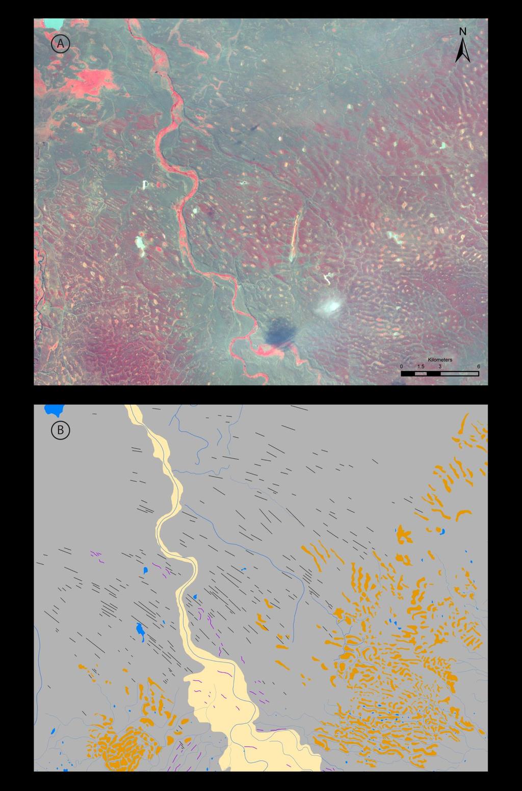
 Landsat ETM+ image (bands 4, 3, 1) and (B) mapped equivalent showing the intersection between lineations")
 lobes.")
34 Figure 9. (A) Landsat ETM+ image (bands 4, 3, 1) and (B) mapped equivalent showing the intersection between lineations (black lines) and irregular dissected ridges (brown polygons) between the Skyring (to the south) and Río Gallegos (to the north and west) lobes. Also shown are moraine ridges as purple lines, meltwater channels as blue lines and outwash as yellow polygons. Location shown in 34
35 Figure 3. 35
36 763 36
A glacial geomorphological map of the Seno Skyring-Seno. Otway-Strait of Magellan region, southernmost Patagonia
 A glacial geomorphological map of the Seno Skyring-Seno Otway-Strait of Magellan region, southernmost Patagonia HAROLD LOVELL*, CHRIS R. STOKES and MICHAEL J. BENTLEY Department of Geography, Durham University,
Durham E-Theses. The nature and timing of Late Quaternary glaciation in southernmost South America DARVILL, CHRISTOPHER
 Durham E-Theses The nature and timing of Late Quaternary glaciation in southernmost South America DARVILL, CHRISTOPHER How to cite: DARVILL, CHRISTOPHER (2015) The nature and timing of Late Quaternary
Supplementary Fig. 1. Locations of thinning transects and photos of example samples. Mt Suess/Gondola Ridge transects extended metres above
 Supplementary Fig. 1. Locations of thinning transects and photos of example samples. Mt Suess/Gondola Ridge transects extended 260 24 metres above the modern surface of Mackay Glacier, and included 16
Introduction to the Special Issue on Glacial Geology and Geomorphology
 Journal of Maps, 2006, i-v Introduction to the Special Issue on Glacial Geology and Geomorphology CHRIS D. CLARK Department of Geography, University of Sheffield, Sheffield, S10 2TN, UK; c.clark@sheffield.ac.uk
Page 1. Name:
 Name: 1) Which property would best distinguish sediment deposited by a river from sediment deposited by a glacier? thickness of sediment layers age of fossils found in the sediment mineral composition
Glacial Modification of Terrain
 Glacial Modification Part I Stupendous glaciers and crystal snowflakes -- every form of animate or inanimate existence leaves its impress upon the soul of man. 1 -Orison Swett Marden Glacial Modification
Education. Professional Experience. Publications (* = 1 st author is, or was, a mentee)
") MICHAEL R. KAPLAN Curriculum Vitae 407 Comer Geochemistry L-DEO of Columbia University mkaplan@ldeo.columbia.edu Education Ph.D., University of Colorado, Geological Sciences Dec, 1999 Major disciplines:
MICHAEL R. KAPLAN Curriculum Vitae 407 Comer Geochemistry L-DEO of Columbia University mkaplan@ldeo.columbia.edu Education Ph.D., University of Colorado, Geological Sciences Dec, 1999 Major disciplines:
PHYSICAL GEOGRAPHY. By Brett Lucas
 PHYSICAL GEOGRAPHY By Brett Lucas GLACIAL PROCESSES Glacial Processes The Impact of Glaciers on the Landscape Glaciations Past and Present Types of Glaciers Glacier Formation and Movement The Effects of
Joseph Martinod, B. Pouyaud, S. Carretier, B. Guillaume, G. Hérail. HAL Id: insu
 Geomorphic Records along the General Carrera (Chile) Buenos Aires (Argentina) Glacial Lake (46 48 S), Climate Inferences, and Glacial Rebound for the Past 7 9 ka : A discusssion Joseph Martinod, B. Pouyaud,
Lowland Glaciation North Wales
 Lowland Glaciation North Wales Background Although there have been many glaciations and advances in ice, the most significant for this are was the Dimlington Stadial which was a period of glacial advance
GSA DATA REPOSITORY
 GSA DATA REPOSITORY 2012186 SUPPLEMENTARY MATERIAL Northern Hemisphere forcing of the last deglaciation in southern Patagonia Daniel S. Murray, Anders E. Carlson*, Brad S. Singer, Faron S. Anslow, Feng
4. The map below shows a meandering stream. Points A, B, C, and D represent locations along the stream bottom.
 1. Sediment is deposited as a river enters a lake because the A) velocity of the river decreases B) force of gravity decreases C) volume of water increases D) slope of the river increases 2. Which diagram
Prentice Hall EARTH SCIENCE
 Prentice Hall EARTH SCIENCE Tarbuck Lutgens Chapter 7 Glaciers, Desert, and Wind 7.1 Glaciers Types of Glaciers A glacier is a thick ice mass that forms above the snowline over hundreds or thousands of
Ice Sheets and Late Quaternary Environmental Change
 Ice Sheets and Late Quaternary Environmental Change Martin J. Siegert Bristol Glaciology Centre, School of Geographical Sciences University of Bristol JOHN WILEY & SONS, LTD Chichester New York Weinheim
The glacial geomorphology of the Lago Buenos Aires and Lago Pueyrredón ice lobes of central Patagonia
 Journal of Maps ISSN: (Print) 1744-5647 (Online) Journal homepage: https://tandfonline.com/loi/tjom20 The glacial geomorphology of the Lago Buenos Aires and Lago Pueyrredón ice lobes of central Patagonia
Reconstruction of the Vistula ice stream lobe during LGM: preliminary results of the research project
 Ice, water, humans Quaternary landscape evolution in the Peribaltic Region 35th Annual conference of the German Quaternary Association DEUQUA e.v. 12th Annual Conference of the INQUA PeriBaltic WG 13th-17th
The Geology of Sebago Lake State Park
 Maine Geologic Facts and Localities September, 2002 43 55 17.46 N, 70 34 13.07 W Text by Robert Johnston, Department of Agriculture, Conservation & Forestry 1 Map by Robert Johnston Introduction Sebago
 Page 1 of 9 Name: Base your answer to the question on the diagram below. The arrows show the direction in which sediment is being transported along the shoreline. A barrier beach has formed, creating a
Evidence of Ice Retreat, East Shore of Sabattus Pond
 Maine Geologic Facts and Localities November, 2002 Evidence of Ice Retreat, East Shore of Sabattus Pond 44 7 25.14 N, 70 5 21.69 W Text by Michael E. Foley, Department of Agriculture, Conservation & Forestry
NDWRCDP Disclaimer This work was supported by the National Decentralized Water Resources Capacity Development Project (NDWRCDP) with funding provided
 with funding provided") Glacial Landforms NDWRCDP Disclaimer This work was supported by the National Decentralized Water Resources Capacity Development Project (NDWRCDP) with funding provided by the U.S. Environmental Protection
Glacial Landforms NDWRCDP Disclaimer This work was supported by the National Decentralized Water Resources Capacity Development Project (NDWRCDP) with funding provided by the U.S. Environmental Protection
QUATERNARY AND GLACIAL GEOLOGY
 QUATERNARY AND GLACIAL GEOLOGY JURGEN EHLERS Geologisches Landesamt, Germany Translated from Allgemeine und historische Quartdrgeologie English version by Philip L. Gibbard JOHN WILEY & SONS Chichester
Geomorphology. Can glacial erosion limit the extent of glaciation? Michael R. Kaplan a,b,, Andrew S. Hein b, Alun Hubbard c, Simon M.
 Geomorphology 103 (2009) 172 179 Contents lists available at ScienceDirect Geomorphology journal homepage: www.elsevier.com/locate/geomorph Can glacial erosion limit the extent of glaciation? Michael R.
4. What type of glacier forms in a sloping valley between rock walls? a. firn glacier b. ice sheet c. cirque d. alpine glacier
 Multiple Choice Questions 1. The term means the loss of snow and ice by evaporation and melting. a. sublimation b. ablation c. erosion d. abrasion 2. What condition must be met for a glacier to begin flowing
Glaciers. (Shaping Earth s Surface, Part 6) Science 330 Summer 2005
 Science 330 Summer 2005") Glaciers (Shaping Earth s Surface, Part 6) Science 330 Summer 2005 1 Glaciers Glaciers are parts of two basic cycles Hydrologic cycle Rock cycle Glacier a thick mass of ice that originates on land from
Glaciers (Shaping Earth s Surface, Part 6) Science 330 Summer 2005 1 Glaciers Glaciers are parts of two basic cycles Hydrologic cycle Rock cycle Glacier a thick mass of ice that originates on land from
GEOL.3250 Geology for Engineers Glacial Geology
 GEOL.3250 Geology for Engineers Glacial Geology NAME Part I: Continental Glaciation Continental glaciers are large ice sheets that cover substantial portions of the land area. In the region of accumulation
What is a Glacier? Types of Glaciers
 Alpine & Continental Glaciers Glacial Mass Balance Glacial Ice Formation Glacial Movement & Erosion Erosional and Depositional Landforms The Pleistocene Epoch Geomorphology of SW Manitoba Chapter 17 1
Glaciers Earth 9th Edition Chapter 18 Glaciers: summary in haiku form Key Concepts Glaciers Glaciers Glaciers Glaciers
 1 2 3 4 5 6 7 8 9 10 11 12 13 14 Earth 9 th Edition Chapter 18 : summary in haiku form Ten thousand years thence big glaciers began to melt - called "global warming." Key Concepts and types of glaciers.
Chapter 2. Wearing Down Landforms: Rivers and Ice. Physical Weathering
 Chapter 2 Wearing Down Landforms: Rivers and Ice Physical Weathering Weathering vs. Erosion Weathering is the breakdown of rock and minerals. Erosion is a two fold process that starts with 1) breakdown
Modeling Patagonian ice sheet extent. during past glaciations. Nat Wilson. Mark T. Brandon and Ronald B. Smith. April 28, 2009
 Modeling Patagonian ice sheet extent during past glaciations Nat Wilson Mark T. Brandon and Ronald B. Smith April 28, 2009 Abstract: The circa 20 ka Last Glacial Maximum and the circa 1 Ma Greatest Patagonian
Chapter 5: Glaciers and Deserts
 I. Glaciers and Glaciation Chapter 5: Glaciers and Deserts A. A thick mass of ice that forms over land from the compaction and recrystallization of snow and shows evidence of past or present flow B. Types
3.13Glaciers past and present
 3.13Glaciers past and present We start with a headline from The Scotsman newspaper that rocked Britain s scientific establishment on the morning of 7 October 1840: 3 Discovery of the Former Existence of
Geochemistry Building L-DEO of Columbia University P.O. Box 1000 Palisades, NY
 MICHAEL R. KAPLAN Geochemistry Building L-DEO of Columbia University P.O. Box 1000 Palisades, NY 10964 mkaplan@ldeo.columbia.edu Curriculum Vitae Education Ph.D., University of Colorado, Geological Sciences
T. Perron Glaciers 1. Glaciers
 T. Perron 12.001 Glaciers 1 Glaciers I. Why study glaciers? [PPT: Perito Moreno glacier, Argentina] Role in freshwater budget o Fraction of earth s water that is fresh (non-saline): 3% o Fraction of earth
MASS MOVEMENTS, WIND, AND GLACIERS
 Date Period Name MASS MOVEMENTS, WIND, AND GLACIERS SECTION.1 Mass Movements In your textbook, read about mass movements. Use each of the terms below just once to complete the passage. avalanche creep
Mass Movements, Wind, and Glaciers
 Mass Movements,, and Glaciers SECTION 8.1 Mass Movement at Earth s Surface In your textbook, read about mass movement. Use each of the terms below just once to complete the passage. avalanche creep landslide
Edinburgh Research Explorer
 Edinburgh Research Explorer The chronology of the Last Glacial Maximum and deglacial events in central Argentine Patagonia Citation for published version: Hein, AS, Hulton, NRJ, Dunai, TJ, Sugden, D, Kaplan,
CARD #1 The Shape of the Land: Effects of Crustal Tilting
 CARD #1 The Shape of the Land: Effects of Crustal Tilting When we look at a birds-eye view of the Great Lakes, it is easy to assume the lakes are all at a similar elevation, but viewed in this way, we
Which landscape best represents the shape of the valleys occupied by glaciers? A) B) C) D)
 B) C) D)") 1. Glaciers often form parallel scratches and grooves in bedrock because glaciers A) deposit sediment in unsorted piles B) deposit rounded sand in V-shaped valleys C) continually melt and refreeze D) drag
1. Glaciers often form parallel scratches and grooves in bedrock because glaciers A) deposit sediment in unsorted piles B) deposit rounded sand in V-shaped valleys C) continually melt and refreeze D) drag
Name: Mid-Year Review #2 SAR
 Name: Mid-Year Review #2 SAR Base your answers to questions 1 through 3 on on the diagram below, which shows laboratory materials used for an investigation of the effects of sediment size on permeability,
Lecture Outlines PowerPoint. Chapter 6 Earth Science 11e Tarbuck/Lutgens
 Lecture Outlines PowerPoint Chapter 6 Earth Science 11e Tarbuck/Lutgens 2006 Pearson Prentice Hall This work is protected by United States copyright laws and is provided solely for the use of instructors
Chapter 2. Denudation: Rivers and Ice
 Chapter 2. Denudation: Rivers and Ice DENUDATION: process that lowers level of land - caused by rivers, glaciers, waves & wind - involves processes of WEATHERING & EROSION Weathering Def: breakdown of
mountain rivers fixed channel boundaries (bedrock banks and bed) high transport capacity low storage input output
 high transport capacity low storage input output") mountain rivers fixed channel boundaries (bedrock banks and bed) high transport capacity low storage input output strong interaction between streams & hillslopes Sediment Budgets for Mountain Rivers Little
mountain rivers fixed channel boundaries (bedrock banks and bed) high transport capacity low storage input output strong interaction between streams & hillslopes Sediment Budgets for Mountain Rivers Little
Reference: climate data for Prince George and other locations at the back of this handout
 Name/Date: Socials 9 Unit 2: Cultures, Conflict, and Colonization in British North America 2A Physical Geography of Canada References: Cranny, M. (1998) Crossroads: A Meeting of Nations, Ch. 6 Canadian
How do glaciers form?
 Glaciers What is a Glacier? A large mass of moving ice that exists year round is called a glacier. Glaciers are formed when snowfall exceeds snow melt year after year Snow and ice remain on the ground
Deglacial landform assemblage records fast ice-flow and retreat, Inner Hebrides, Scotland
 Deglacial landform assemblage records fast ice-flow and retreat, Inner Hebrides, Scotland D. DOVE 1*, A. FINLAYSON 1, T., BRADWELL 1,2, J. A. HOWE 3 & R. AROSIO 3 1 British Geological Survey, Murchison
SAMPLE PAGE. pulses. The Ice Age By: Sue Peterson
 Page 61 Objective sight words (pulses, intermittent, isotopes, chronicle, methane, tectonic plates, volcanism, configurations, land-locked, erratic); concepts (geological evidence and specific terminology
Supplementary Figure 1. Normalized glacier terminus elevation changes versus normalized glacier length changes.
 Supplementary Figure 1. Normalized glacier terminus elevation changes versus normalized glacier length changes. Supplementary Figure 2. Normalized glacier lengths through time, as shown in Fig. 2 in the
Geology and New England Landscapes
 Geology and New England Landscapes Jim Turenne, CPSS USDA-NRCS Warwick, RI. http://nesoil.com Why Geology? Provides the big picture of site conditions. Major part of soil formation (parent material and
Late Cenozoic glaciations in Patagonia and Tierra del Fuego: an updated review
 316..335 Biological Journal of the Linnean Society, 2011, 103, 316 335. With 6 figures Late Cenozoic glaciations in Patagonia and Tierra del Fuego: an updated review JORGE RABASSA 1,2 *, ANDREA CORONATO
Examining the Terrestrial Planets (Chapter 20)
") GEOLOGY 306 Laboratory Instructor: TERRY J. BOROUGHS NAME: Examining the Terrestrial Planets (Chapter 20) For this assignment you will require: a calculator, colored pencils, a metric ruler, and your geology
GEOLOGY 306 Laboratory Instructor: TERRY J. BOROUGHS NAME: Examining the Terrestrial Planets (Chapter 20) For this assignment you will require: a calculator, colored pencils, a metric ruler, and your geology
Name: Class: Date: Multiple Choice Identify the letter of the choice that best completes the statement or answers the question.
 Name: Class: Date: geology ch 7 test 2008 Multiple Choice Identify the letter of the choice that best completes the statement or answers the question. 1. Which of the following is true about ice sheets?
Name: Which rock layers appear to be most resistant to weathering? A) A, C, and E B) B and D
 A, C, and E B) B and D") Name: 1) The formation of soil is primarily the result of A) stream deposition and runoff B) precipitation and wind erosion C) stream erosion and mass movement D) weathering and biological activity 2)
Name: 1) The formation of soil is primarily the result of A) stream deposition and runoff B) precipitation and wind erosion C) stream erosion and mass movement D) weathering and biological activity 2)
Name Roy G Biv Page 1
 Name Roy G Biv Base your answers to questions 1 through 3 on the diagram below. The arrows show the direction in which sediment is being transported along the shoreline. A barrier beach has formed, creating
What are the different ways rocks can be weathered?
 Romano - 223 What are the different ways rocks can be weathered? Weathering - the breakdown of rocks and minerals at the Earth s surface 1. 2. PHYSICAL WEATHERING Rock is broken into smaller pieces with
Maggie Payne Jim Turenne
 Maggie Payne Jim Turenne USDA-NRCS 60 Quaker Lane, Suite 46 Warwick, RI. 02886 401-822-8832 maggie.payne@ri.usda.gov U.S. Department of Agriculture 1935: Soil Conservation Service (SCS) Natural Resources
Page 1. Name:
 Name: 1) Which event is the best example of erosion? dissolving of rock particles on a limestone gravestone by acid rain breaking apart of shale as a result of water freezing in a crack rolling of a pebble
LONG ISLAND CLAST ORIENTATIONS
 LONG ISLAND CLAST ORIENTATIONS AND WHAT THEY TILL US Elliot Klein and Dan Davis Department of Geosciences, State University of New York at Stony Brook, 11794 Long Island glacigenic surface deposits, where
Photogeologic Mapping of Mars
 Exercise Two and Fifteen are suggested as introductory exercises. 2.0 hours Exercise Seventeen Photogeologic Mapping of Mars Instructor Notes Suggested Correlation of Topics Deductive reasoning, geologic
Glacial processes and landforms NGEA01, 2014
 Glacial processes and landforms NGEA01, 2014 Cecilia Akselsson Department of Physical Geography and Ecosystem Science Lund University Geomorphological processes and landforms all over the world Periglacial
Enigmatic boulder trains, supraglacial rock avalanches, and the origin of Darwin s boulders, Tierra del Fuego
 Enigmatic boulder trains, supraglacial rock avalanches, and the origin of Darwin s boulders, Tierra del Fuego Edward B. Evenson, Dept. of Earth and Environmental Sciences, Lehigh University, Bethlehem,
MSc(Res) Polar and Alpine Change.
 Polar and Alpine Change.") Department Of Geography. MSc(Res) Polar and Alpine Change. MSc(Res) Polar and Alpine Change Our MSc(Res) Polar and Alpine Change programme provides a unique research experience that seeks to embed our
Department Of Geography. MSc(Res) Polar and Alpine Change. MSc(Res) Polar and Alpine Change Our MSc(Res) Polar and Alpine Change programme provides a unique research experience that seeks to embed our
Name. 4. The diagram below shows a soil profile formed in an area of granite bedrock. Four different soil horizons, A, B, C, and D, are shown.
 Name 1. In the cross section of the hill shown below, which rock units are probably most resistant to weathering? 4. The diagram below shows a soil profile formed in an area of granite bedrock. Four different
BLAKENEY ESKER AND HOW IT FORMED. The Blakeney Esker is a ridge, around 3.5 km in length, which runs southeastwards
 BLAKENEY ESKER AND HOW IT FORMED Introduction The Blakeney Esker is a ridge, around 3.5 km in length, which runs southeastwards from west of Blakeney, to Wiveton Downs, north-west of Glandford, in north
Areal Scour vs. Selective Linear Erosion
 Erosional Forms and Landscapes Erosional Landscapes Areal Scour vs. Selective Linear Erosion Cirques Form and Morphology Many Forms Red Tarn Cirque Basin English Lake District Red Tarn Cirque Basin, English
3. GEOLOGY. 3.1 Introduction. 3.2 Results and Discussion Regional Geology Surficial Geology Mine Study Area
 3. GEOLOGY 3.1 Introduction This chapter discusses the baseline study of the geology and mineralization characteristics of the mine study area. The study consolidates existing geological data and exploration
Surface Process Hazards Unit 2: Landscape Feature Scavenger Hunt
 Surface Process Hazards Unit 2: Landscape Feature Scavenger Hunt Sarah Hall (College of the Atlantic) and Becca Walker (Mt. San Antonio College) The following pages each have a series of questions about
Last Time. Submarine Canyons and Fans. Turbidites. MAS 603: Geological Oceanography. Lecture 16: Greenhouse vs. Icehouse Earths
 UNIVERSITY OF SOUTH ALABAMA Last Time MAS 603: Geological Oceanography Lecture 16: Greenhouse vs. Icehouse Earths Submarine Fans Definition and morphology Transport mechanisms (density currents) Submarine
Periglacial Geomorphology
 Periglacial Geomorphology Periglacial Geomorphology Periglacial: literally means around glacial - term introduced in 1909 to describe landforms and processes around glaciated areas. Periglacial environments:
RETREAT OF THE CORDILLERA DARWIN ICEFIELD DURING TERMINATION I
 Cuadernos de Investigación Geográfica Geographical Research Letters DOI: http://doi.org/10.18172/cig.3158 ISSN 0211-6820 2017 Nº 43 (2) pp. 751-766 eissn 1697-9540 Universidad de La Rioja RETREAT OF THE
1. Any process that causes rock to crack or break into pieces is called physical weathering. Initial product = final product
 Weathering 1. Any process that causes rock to crack or break into pieces is called physical weathering. Initial product = final product End Result of physical weathering is increased surface area. 2. Physical
Investigating Glacial Landscape Systems 3 days
 AS Level Geography OCR Investigating Glacial Landscape Systems 3 days Deliver two full days of fieldwork within an inspiring physical environment. Prepare AS level students for the Paper 1: Landscape and
THE JUAN DE FUCA LOBE OF THE CORDILLERAN ICE SHEET
 THE JUAN DE FUCA LOBE OF THE CORDILLERAN ICE SHEET There were two large glaciers in western Washington during the latest, or Vashon, glaciation of that region. Each was essentially an elongated lobe of
Southern Patagonian glacial chronology for the Last Glacial period and implications for Southern Ocean climate
 Quaternary Science Reviews 27 (2008) 284 294 Southern Patagonian glacial chronology for the Last Glacial period and implications for Southern Ocean climate M.R. Kaplan a,b,, C.J. Fogwill a,c, D.E. Sugden
Site 4.7. Thornhill Drumlin Jane K. Hart
 Site 4.7. Thornhill Drumlin Jane K. Hart Introduction The drumlins in the West of Ireland represent some of the best exposured features in the whole of Britain and Ireland, and have been studied by numerous
The landforms of Svalbard
 The landforms of Svalbard Content Periglacial landforms -) ice-wedges -) rock glaciers -) pingos -) solifluction -) avalanches -) debris flows -) rock falls -) nivation -) aeolian landforms Glacial landforms
CHANGING LANDSCAPES AND CHANGING PLACES SAMPLE ASSESSMENT MATERIALS
 A LEVEL GEOGRAPHY Sample Assessment Materials 5 A LEVEL GEOGRAPHY COMPONENT 1 CHANGING LANDSCAPES AND CHANGING PLACES SAMPLE ASSESSMENT MATERIALS 1 hour 45 minutes ADDITIONAL MATERIALS In addition to this
CURRICULUM TR AILING ICE AGE M YST ERI E S
 MIDDLE SCHOOL CURRICULUM TR AILING ICE AGE M YST ERI E S THE Driftless Area CONTENTS I. Enduring Knowledge... 3 II. Teacher Background... 3 III. Before Viewing the Video... 5 IV. Viewing Guide... 5 V.
Loess and dust. Jonathan A. Holmes Environmental Change Research Centre
 Loess and dust Jonathan A. Holmes Environmental Change Research Centre Why is dust important? Mineral dust is an important constituent of the solid load in Earth's atmosphere, the total atmospheric aerosol
2/23/2009. Visualizing Earth Science. Chapter Overview. Deserts and Drylands. Glaciers and Ice Sheets
 Visualizing Earth Science By Z. Merali and B. F. Skinner Chapter 6 Deserts, Glaciers and Ice Sheets Chapter Overview Deserts and Drylands Glaciers and Ice Sheets Deserts Geography Categorization of deserts
Ice Thickness and Subglacial Topography Studies by Ground Penetrating Radar during the XX Indian Antarctic Expedition
 Ice Thickness and Subglacial Topography Studies by Ground Penetrating Radar during the XX Indian Antarctic Expedition J.T. GERGAN and RENOJ J. THAYYEN Wadia Institute of Himalayan Geology, Dehradun, Uttaranchal
Jim Turenne. Soils on Social Media
 Jim Turenne USDA-NRCS 60 Quaker Lane, Suite 46 Warwick, RI. 02886 401-822-8832 Jim.turenne@ri.usda.gov Soils on Social Media www.twitter.com/soilsne www.fb.com/soilsne www.nesoil.com U.S. Department of
Exploring Geography. Chapter 1
 Exploring Geography Chapter 1 The Study of Geography Geography is the study of where people, places, and things are located and how they relate to each other. Greek meaning writing about or describing
Moosehead Lake and the Tale of Two Rivers
 Maine Geologic Facts and Localities June, 2005 45 o 53 5.09 N, 69 o 42 14.54 W Text by Kelley, A.R.; Kelley, J.T.; Belknap, D.F.; and Gontz, A.M. Department of Earth Sciences, University of Maine, Orono,
Landscape evolution. An Anthropic landscape is the landscape modified by humans for their activities and life
 Landforms Landscape evolution A Natural landscape is the original landscape that exists before it is acted upon by human culture. An Anthropic landscape is the landscape modified by humans for their activities
The boulder was most likely moved to this location by A) glacial ice B) prevailing wind C) streamfiow D) volcanic action
 glacial ice B) prevailing wind C) streamfiow D) volcanic action") 1. Which rock material was most likely transported to its present location by a glacier? A) rounded sand grains found in a river delta B) rounded grains found in a sand dune C) residual soil found on a
1. Which rock material was most likely transported to its present location by a glacier? A) rounded sand grains found in a river delta B) rounded grains found in a sand dune C) residual soil found on a
Class Notes: Surface Processes
 Name: Date: Period: Surface Processes The Physical Setting: Earth Science Class Notes: Surface Processes I. Weathering and Soils Weathering -! Sediments -! Weathering occurs when rocks are exposed to:
Grade 9 Social Studies Canadian Identity. Chapter 2 Review Canada s Physical Landscape
 Grade 9 Social Studies Canadian Identity Chapter 2 Review Canada s Physical Landscape Name: Unit 1: Empowerment Terms (notes or textbook) 1. Core 2. Crust 3. Mantle 4. Magma 5. Continental drift 6. Plate
Data Quality and Uncertainty
 Data Quality and Uncertainty The power of GIS analysis is based on the assembly of layers of data, but as data layers increase, errors multiply - quality decreases. Garbage in, garbage out. High quality
Ch 10 Deposition Practice Questions
 1. Base your answer to the following question on the data table below. Six identical cylinders, A through F, were filled with equal volumes of sorted spherical particles. The data table shows the particle
Chapter 1 Section 2. Land, Water, and Climate
 Chapter 1 Section 2 Land, Water, and Climate Vocabulary 1. Landforms- natural features of the Earth s land surface 2. Elevation- height above sea level 3. Relief- changes in height 4. Core- most inner
DIGITAL ELEVATION MODELS FROM SHUTTLE RADAR TOPOGRAPHY MISSION DATA NEW INSIGHTS INTO THE QUATERNARY HISTORY OF NEWFOUNDLAND
 Current Research (2006) Newfoundland and Labrador Department of Natural Resources Geological Survey, Report 06-1, pages 177-189 DIGITAL ELEVATION MODELS FROM SHUTTLE RADAR TOPOGRAPHY MISSION DATA NEW INSIGHTS
Glaciers form wherever snow and ice can accumulate High latitudes High mountains at low latitudes Ice temperatures vary among glaciers Warm
 The Cryosphere Glaciers form wherever snow and ice can accumulate High latitudes High mountains at low latitudes Ice temperatures vary among glaciers Warm (temperate) glaciers: at pressure melting point,
Rapid Communication. Constraining Holocene 10 Be production rates in Greenland. Introduction. Jakobshavn Isfjord, west Greenland. Radiocarbon dating
 JOURNAL OF QUATERNARY SCIENCE (2012) 27(1) 2 6 ISSN 0267-8179. DOI: 10.1002/jqs.1562 Rapid Communication Constraining Holocene 10 Be production rates in Greenland JASON P. BRINER, 1 * NICOLÁS E. YOUNG,
Bell Ringer. Are soil and dirt the same material? In your explanation be sure to talk about plants.
 Bell Ringer Are soil and dirt the same material? In your explanation be sure to talk about plants. 5.3 Mass Movements Triggers of Mass Movements The transfer of rock and soil downslope due to gravity is
Lecture Outline Lecture Outline Monday April 9-16, 2018 Questions? Announcements:
 Lecture Outline Lecture Outline Monday April 9-16, 2018 Questions? Announcements: Geology 101 Night Video: The Day After Tomorrow Hollywood disaster movie about the onset of a glacial period When: Monday
Maximum Extent of Pleistocene Glaciation - 1/3 of land surface Most recent glacial maximum peaked 18,000 years ago and is considered to have ended
 Glaciers Maximum Extent of Pleistocene Glaciation - 1/3 of land surface Most recent glacial maximum peaked 18,000 years ago and is considered to have ended 10,000 B.P. Current Extent of Glaciation - about
Foundations of Earth Science, 6e Lutgens, Tarbuck, & Tasa
 Foundations of Earth Science, 6e Lutgens, Tarbuck, & Tasa Glacial and Arid Landscapes Foundations, 6e - Chapter 4 Stan Hatfield Southwestern Illinois College Glaciers Glaciers are parts of two basic cycles
Figure 1 The map shows the top view of a meandering stream as it enters a lake. At which points along the stream are erosion and deposition dominant?
 1. In which type of climate does chemical weathering usually occur most rapidly? 1. hot and dry 3. cold and dry 2. hot and wet 4. cold and wet 2. Figure 1 The map shows the top view of a meandering stream
THE ACTION OF GLACIERS
 Surface processes THE ACTION OF GLACIERS Glaciers are enormous masses of ice which are formed due to accumulation, compaction and re-crystallisation of the snow deposited in very cold regions (the majority
Pratice Surface Processes Test
 1. The cross section below shows the movement of wind-driven sand particles that strike a partly exposed basalt cobble located at the surface of a windy desert. Which cross section best represents the