Maximum Extent of Pleistocene Glaciation - 1/3 of land surface Most recent glacial maximum peaked 18,000 years ago and is considered to have ended
|
|
|
- Shannon Simmons
- 5 years ago
- Views:
Transcription
1 Glaciers
2 Maximum Extent of Pleistocene Glaciation - 1/3 of land surface Most recent glacial maximum peaked 18,000 years ago and is considered to have ended 10,000 B.P.

3 Current Extent of Glaciation - about 10% of land surface

4 Worldʼs s snowline

5 High latitude icecaps

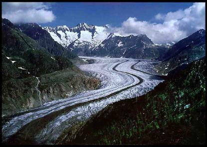
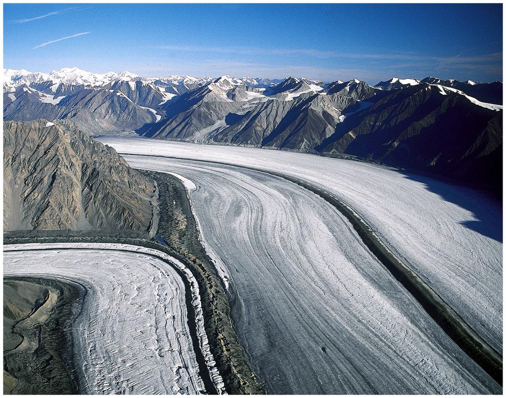
6 Valley glaciers Aletsch
 Ablation (mass loss) below equilibrium line.")
7 Valley glaciers mass balance results from interplay of: 1) accumulation of snow above equilibrium line and transformation of snow crystals to firn and glacial ice. 2) Ablation (mass loss) below equilibrium line. Accumulation> Ablation Valley glacier moves forward Ablation> Accumulation Valley glacier retreats
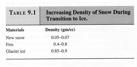
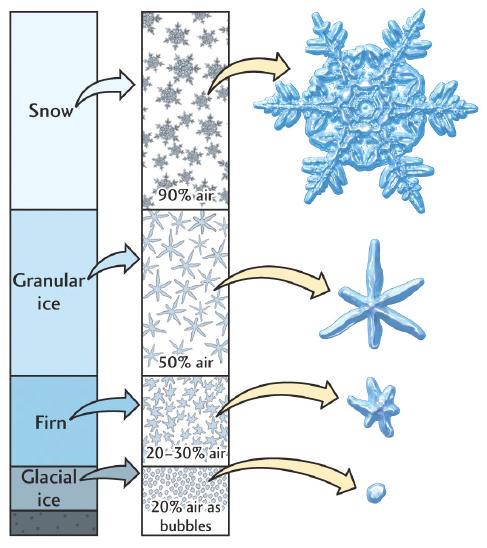
8 Transformation of snow to glacier ice Snow Glacier ice Firn Glacier ice


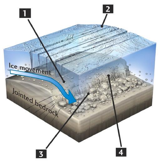
9 How do glaciers move? Glaciers must be thick enough so that they flow downslope. Flow is by basal slip or plastic flow. Plastic flow -- ice deforms internally and flows like plastic Basal slip -- ice moves over a thin layer of meltwater
10

11 Landforms produced by valley (alpine) glacier erosion U-shaped valleys - Horns - Cirques - Arêtes - Hanging valleys Before glaciation After glaciation


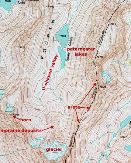
12 Landforms produced by erosion Cirques Horns Hanging valley U-shaped valley
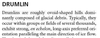
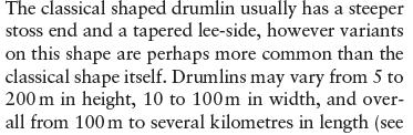
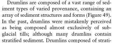
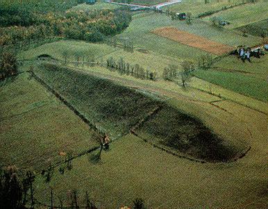
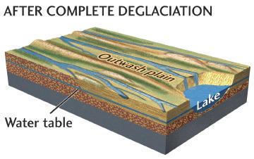
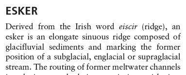
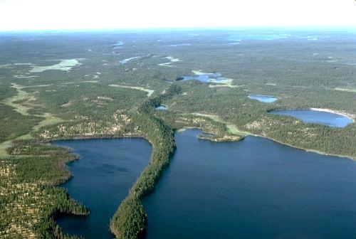
13 Glacial deposits and associated landforms Glacial Deposits Drift -- general term applied to any deposit associated with glaciers Till -- sediment deposited directly from melting ice; till is unsorted and unstratified Outwash -- sediment deposited by meltwater streams These deposits are stratified and sorted. Landforms made of till Moraines -- ridges made of till that form at margins of a glacier Drumlins -- streamlined hills made (frequently, but not always) of till; steeper on the side from which ice came. Landforms made of stratified drift: Kames -- small, steep-sided hills or mounds made of sediments are deposited in meltwater lake or meltwater streams. Eskers are sinuous ridges made of stratified drift. The stratified drift is deposited in sub glacial meltwater streams. Kettle --


14 median End (or Terminal) moraine -- forms at bottom end of glacier Lateral moraine -- forms at side of glacier Ground moraine -- forms by deposition of till at the base of a glacier; not a ridge, just a lumpy plain. Medial Moraine when two glacial valleys merge


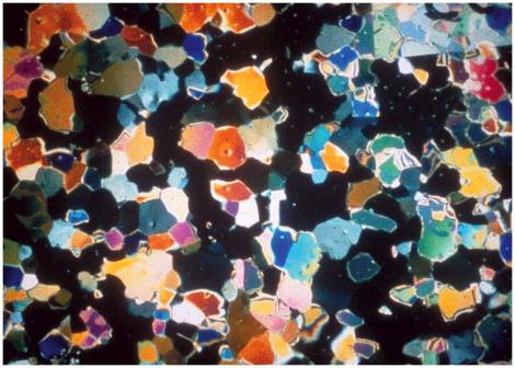
15 Moraine till is usually made of ill-sorted, matrix-abundant deposits with poorly rounded clasts
16
17
18
19

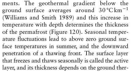
20 Permafrost, mean annual temperatures, and rock glaciers formation Permafrost: soil at or below the freezing point of water (0 C) for two or more years. - ice is not always present, but it frequently occurs - most permafrost is located in high latitudes, but alpine permafrost may exist at high altitudes in much lower latitudes.
21 Permafrost profile in equilibrium

22 Permafrost profile during adjustment to surface warming 20 Lugano T medie Davos T medie Milano T medie Basel T medie Temp medie*.kg
23 warming


24 Permafrost melting, rockfalls and rock glaciers formation
25 Glaciers, erosion, and isostasy. Isostasy is a term used in geology to refer to the state of gravitational equilibrium between the earth's lithosphere and asthenosphere such that the tectonic plates "float" at an elevation which depends on their thickness and density. Let us take for simplicity the example of ice floating in water. Z T Z U Z L A block of ice (density = g/cm 3 ) is floating in the water (density = 1.00 g/cm 3 ). Let Z T = total thickness of ice block. Let Z U = the upper part (above water level). Let Z L = the lower part (below water level).

26 Glaciers, erosion, and isostasy. The pressure exerted by the block of ice on point A is P A =ρ ice g Z T while the pressure exerted by the adjacent column of water on point B is P B = ρ water g Z L Z T Z U Z L The block of ice is said to be in isostatic equilibrium when P A = P B and the dashed horizontal line along which pressure is the same is known as the depth of compensation. At P A = P B we have that: ρ ice g Z T = ρ water g Z L knowing that Z T = Z U + Z L Z L = Z T (ρ ice / ρ water ) Z U = Z T (ρ water ρ ice ) / ρ water For Z T = 200 m, Z U = 16.6 m For Z T = 150 m, Z U = 12.4 m For Z T = 100 m, Z U = 8.3 m For Z T = 50 m, Z U = 4.1 m
27 Imagine to take away from an ice block of thickness Z T1 a chunck of ice of thickness Z U1 emerging from sea level (panel 1). The new block (panel 2) will no more be in isostatic equilibrium because P B > P A and water will flow from B to A so that the block will rise (uplift) to a new compensation depth until P B = P A (panel 3) attaining a final elevation above sea level of Z U2 < Z U1 1) Z U1 2) 3) Z U2 Z T1 Z L1 Z T2 Z T2 Start in panel 1 with an iceberg of thickness Z T1 = 200 m; this iceberg emerges from sea level by Z U1 = 17 m and is submerged by Z L1 = 183 m. Now take away the emerging upper 17 m of the iceberg to obtain a new iceberg of thickness Z T2 = 183 m (panel 2). This new iceberg will uplift by 15 m to a new equilibrium position such that it will emerge from sea level by Z U2 = 15 m (panel 3). Erosion followed by isostatic compensation causes uplift and loss of elevation. Elevation loss = erosion - uplift = 17m - 15m = 2m

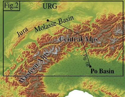
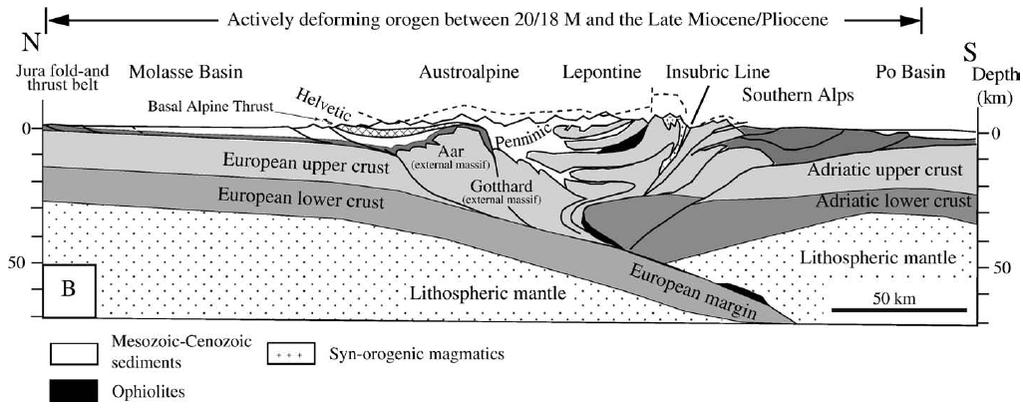
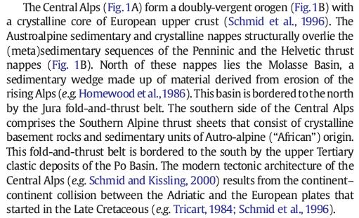
28 This leads to the rather couterintuitive conclusion that by eroding material from an elevated area, e.g., a mountain range, and allowing for isostatic compensation, the mountain range will tend to uplift and at the same time diminish its mean elevation (not to be confused with relief). This is why by erosion, old mountain ranges (m.r.) tend to have low elevations and their deepest roots exposed. This is valid for areas with no active horizontal (tectonic) deformation. Alps (young m.r.) Appalachians (old m.r.)

29 Fjeldskaar et al., QSR 2002
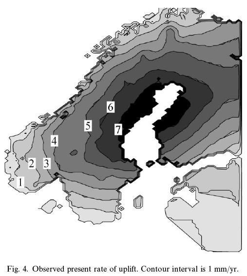
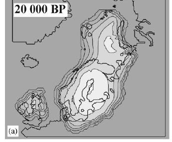
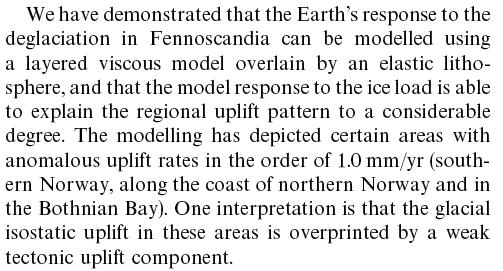
30 Fjeldskaar et al., QSR 2002


31 Scardia, Muttoni & Sciunnach GSA 2006 Beginning of major ice ages In the Alps at ~0.9 Ma (Muttoni et al., 2003; Scardia et al., 2006). Repeated waxing and waning of Alpine glaciers since then. Last major ice age ~ yrs ago
32
33 Champagnac et al. Tectonophysics 2009

34 Champagnac et al. Tectonophysics 2009

35 End glaciers Champagnac et al. Tectonophysics 2009
Glaciers Earth 9th Edition Chapter 18 Glaciers: summary in haiku form Key Concepts Glaciers Glaciers Glaciers Glaciers
 1 2 3 4 5 6 7 8 9 10 11 12 13 14 Earth 9 th Edition Chapter 18 : summary in haiku form Ten thousand years thence big glaciers began to melt - called "global warming." Key Concepts and types of glaciers.
Glaciers. (Shaping Earth s Surface, Part 6) Science 330 Summer 2005
 Science 330 Summer 2005") Glaciers (Shaping Earth s Surface, Part 6) Science 330 Summer 2005 1 Glaciers Glaciers are parts of two basic cycles Hydrologic cycle Rock cycle Glacier a thick mass of ice that originates on land from
Glaciers (Shaping Earth s Surface, Part 6) Science 330 Summer 2005 1 Glaciers Glaciers are parts of two basic cycles Hydrologic cycle Rock cycle Glacier a thick mass of ice that originates on land from
4. What type of glacier forms in a sloping valley between rock walls? a. firn glacier b. ice sheet c. cirque d. alpine glacier
 Multiple Choice Questions 1. The term means the loss of snow and ice by evaporation and melting. a. sublimation b. ablation c. erosion d. abrasion 2. What condition must be met for a glacier to begin flowing
Foundations of Earth Science, 6e Lutgens, Tarbuck, & Tasa
 Foundations of Earth Science, 6e Lutgens, Tarbuck, & Tasa Glacial and Arid Landscapes Foundations, 6e - Chapter 4 Stan Hatfield Southwestern Illinois College Glaciers Glaciers are parts of two basic cycles
What is a Glacier? Types of Glaciers
 Alpine & Continental Glaciers Glacial Mass Balance Glacial Ice Formation Glacial Movement & Erosion Erosional and Depositional Landforms The Pleistocene Epoch Geomorphology of SW Manitoba Chapter 17 1
Lecture Outlines PowerPoint. Chapter 6 Earth Science 11e Tarbuck/Lutgens
 Lecture Outlines PowerPoint Chapter 6 Earth Science 11e Tarbuck/Lutgens 2006 Pearson Prentice Hall This work is protected by United States copyright laws and is provided solely for the use of instructors
Chapter 5: Glaciers and Deserts
 I. Glaciers and Glaciation Chapter 5: Glaciers and Deserts A. A thick mass of ice that forms over land from the compaction and recrystallization of snow and shows evidence of past or present flow B. Types
Landscape. Review Note Cards
 Landscape Review Note Cards Last Ice Age Pleistocene Epoch that occurred about 22,000 Years ago Glacier A large, long lasting mass of ice which forms on land and moves downhill because of gravity. Continental
1. Any process that causes rock to crack or break into pieces is called physical weathering. Initial product = final product
 Weathering 1. Any process that causes rock to crack or break into pieces is called physical weathering. Initial product = final product End Result of physical weathering is increased surface area. 2. Physical
Glaciers form wherever snow and ice can accumulate High latitudes High mountains at low latitudes Ice temperatures vary among glaciers Warm
 The Cryosphere Glaciers form wherever snow and ice can accumulate High latitudes High mountains at low latitudes Ice temperatures vary among glaciers Warm (temperate) glaciers: at pressure melting point,
Prentice Hall EARTH SCIENCE
 Prentice Hall EARTH SCIENCE Tarbuck Lutgens Chapter 7 Glaciers, Desert, and Wind 7.1 Glaciers Types of Glaciers A glacier is a thick ice mass that forms above the snowline over hundreds or thousands of
Guided Notes Surface Processes. Erosion & Deposition By: Glaciers
 Guided Notes Surface Processes Erosion & Deposition By: Glaciers K. Coder 2015 26) How does moving ice erode and deposit sediments? Glaciers (Movement of Ice): a naturally formed mass of ice and snow that
How do glaciers form?
 Glaciers What is a Glacier? A large mass of moving ice that exists year round is called a glacier. Glaciers are formed when snowfall exceeds snow melt year after year Snow and ice remain on the ground
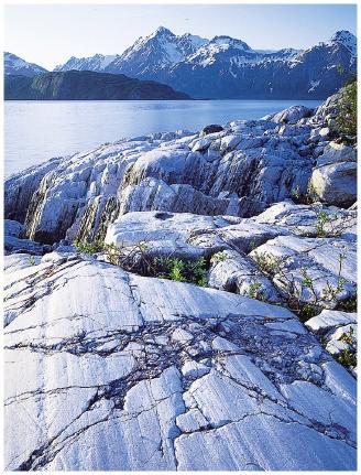
INDEX_Glaciers.pdf. mountain (alpine) glacier NLG Test bank: [Glaciers01-03.jpg] High Quality: [Moraine_med-lat_Haines_AK_.jpg]
![INDEX_Glaciers.pdf. mountain (alpine) glacier NLG Test bank: [Glaciers01-03.jpg] High Quality: [Moraine_med-lat_Haines_AK_.jpg]](/thumbs/83/88580835.jpg "INDEX_Glaciers.pdf. mountain (alpine) glacier NLG Test bank: [Glaciers01-03.jpg] High Quality: [Moraine_med-lat_Haines_AK_.jpg]") Glaciers_INDEX.pdf This is an index of all terms/ideas in this question bank. Question banks are organized into topics containing related terms/ideas. Each term/idea has at least one related question,
Glaciers_INDEX.pdf This is an index of all terms/ideas in this question bank. Question banks are organized into topics containing related terms/ideas. Each term/idea has at least one related question,
Glacial processes and landforms NGEA01, 2014
 Glacial processes and landforms NGEA01, 2014 Cecilia Akselsson Department of Physical Geography and Ecosystem Science Lund University Geomorphological processes and landforms all over the world Periglacial
Lecture 10 Glaciers and glaciation
 Lecture 10 Glaciers and glaciation Outline Importance of ice to people! Basics of glaciers formation, classification, mechanisms of movement Glacial landscapes erosion and deposition by glaciers and the
Glacial Modification of Terrain
 Glacial Modification Part I Stupendous glaciers and crystal snowflakes -- every form of animate or inanimate existence leaves its impress upon the soul of man. 1 -Orison Swett Marden Glacial Modification
4 Formation of glacial ice 3. 5 Formation of glacial ice (cont.) 3. 6 Glacier economy and general flow structure 4
 3. 6 Glacier economy and general flow structure 4") Contents 1 Glacier Flow 2 2 Definition 2 3 Amount 3 4 Formation of glacial ice 3 5 Formation of glacial ice (cont.) 3 6 Glacier economy and general flow structure 4 7 Example 5 8 Examples 6 9 Ice movement
Contents 1 Glacier Flow 2 2 Definition 2 3 Amount 3 4 Formation of glacial ice 3 5 Formation of glacial ice (cont.) 3 6 Glacier economy and general flow structure 4 7 Example 5 8 Examples 6 9 Ice movement
Mass Movements, Wind, and Glaciers
 Mass Movements,, and Glaciers SECTION 8.1 Mass Movement at Earth s Surface In your textbook, read about mass movement. Use each of the terms below just once to complete the passage. avalanche creep landslide
How to Use This Presentation
 How to Use This Presentation To View the presentation as a slideshow with effects select View on the menu bar and click on Slide Show. To advance through the presentation, click the right-arrow key or
Chapter 9 Notes: Ice and Glaciers, Wind and Deserts
 Chapter 9 Notes: Ice and Glaciers, Wind and Deserts *Glaciers and Glacial Features glacier is a mass of ice that moves over land under its own weight through the action of gravity Glacier Formation must
THE ACTION OF GLACIERS
 Surface processes THE ACTION OF GLACIERS Glaciers are enormous masses of ice which are formed due to accumulation, compaction and re-crystallisation of the snow deposited in very cold regions (the majority
2/23/2009. Visualizing Earth Science. Chapter Overview. Deserts and Drylands. Glaciers and Ice Sheets
 Visualizing Earth Science By Z. Merali and B. F. Skinner Chapter 6 Deserts, Glaciers and Ice Sheets Chapter Overview Deserts and Drylands Glaciers and Ice Sheets Deserts Geography Categorization of deserts
PHYSICAL GEOGRAPHY. By Brett Lucas
 PHYSICAL GEOGRAPHY By Brett Lucas GLACIAL PROCESSES Glacial Processes The Impact of Glaciers on the Landscape Glaciations Past and Present Types of Glaciers Glacier Formation and Movement The Effects of
Lecture Outline Lecture Outline Monday April 9-16, 2018 Questions? Announcements:
 Lecture Outline Lecture Outline Monday April 9-16, 2018 Questions? Announcements: Geology 101 Night Video: The Day After Tomorrow Hollywood disaster movie about the onset of a glacial period When: Monday
T. Perron Glaciers 1. Glaciers
 T. Perron 12.001 Glaciers 1 Glaciers I. Why study glaciers? [PPT: Perito Moreno glacier, Argentina] Role in freshwater budget o Fraction of earth s water that is fresh (non-saline): 3% o Fraction of earth
Amazing Ice: Glaciers and Ice Ages
 Amazing Ice: Glaciers and Ice Ages Updated by: Rick Oches, Professor of Geology & Environmental Sciences Bentley University Waltham, Massachusetts Based on slides prepared by: Ronald L. Parker, Senior
MASS MOVEMENTS, WIND, AND GLACIERS
 Date Period Name MASS MOVEMENTS, WIND, AND GLACIERS SECTION.1 Mass Movements In your textbook, read about mass movements. Use each of the terms below just once to complete the passage. avalanche creep
Name: Class: Date: Multiple Choice Identify the letter of the choice that best completes the statement or answers the question.
 Name: Class: Date: geology ch 7 test 2008 Multiple Choice Identify the letter of the choice that best completes the statement or answers the question. 1. Which of the following is true about ice sheets?
3 Erosion and Deposition by Ice
 CHAPTER 12 3 Erosion and Deposition by Ice SECTION Agents of Erosion and Deposition BEFORE YOU READ After you read this section, you should be able to answer these questions: What are glaciers? How do
Which landscape best represents the shape of the valleys occupied by glaciers? A) B) C) D)
 B) C) D)") 1. Glaciers often form parallel scratches and grooves in bedrock because glaciers A) deposit sediment in unsorted piles B) deposit rounded sand in V-shaped valleys C) continually melt and refreeze D) drag
1. Glaciers often form parallel scratches and grooves in bedrock because glaciers A) deposit sediment in unsorted piles B) deposit rounded sand in V-shaped valleys C) continually melt and refreeze D) drag
Bell Ringer. Are soil and dirt the same material? In your explanation be sure to talk about plants.
 Bell Ringer Are soil and dirt the same material? In your explanation be sure to talk about plants. 5.3 Mass Movements Triggers of Mass Movements The transfer of rock and soil downslope due to gravity is
Glaciers and Ice Ages
 ES 106 Glaciers and Ice Ages I. Glacier thick mass of ice accumulated over years, decades, centuries A. Function of recrystallization of fallen snow B. Types 1. alpine valley: a. high elevations worldwide
Page 1. Name:
 Name: 1) Which property would best distinguish sediment deposited by a river from sediment deposited by a glacier? thickness of sediment layers age of fossils found in the sediment mineral composition
Chapter 2. Wearing Down Landforms: Rivers and Ice. Physical Weathering
 Chapter 2 Wearing Down Landforms: Rivers and Ice Physical Weathering Weathering vs. Erosion Weathering is the breakdown of rock and minerals. Erosion is a two fold process that starts with 1) breakdown
Lecture 21: Glaciers and Paleoclimate Read: Chapter 15 Homework due Thursday Nov. 12. What we ll learn today:! Learning Objectives (LO)
") Learning Objectives (LO) Lecture 21: Glaciers and Paleoclimate Read: Chapter 15 Homework due Thursday Nov. 12 What we ll learn today:! 1. 1. Glaciers and where they occur! 2. 2. Compare depositional and
Learning Objectives (LO) Lecture 21: Glaciers and Paleoclimate Read: Chapter 15 Homework due Thursday Nov. 12 What we ll learn today:! 1. 1. Glaciers and where they occur! 2. 2. Compare depositional and
NDWRCDP Disclaimer This work was supported by the National Decentralized Water Resources Capacity Development Project (NDWRCDP) with funding provided
 with funding provided") Glacial Landforms NDWRCDP Disclaimer This work was supported by the National Decentralized Water Resources Capacity Development Project (NDWRCDP) with funding provided by the U.S. Environmental Protection
Glacial Landforms NDWRCDP Disclaimer This work was supported by the National Decentralized Water Resources Capacity Development Project (NDWRCDP) with funding provided by the U.S. Environmental Protection
Science Olympiad Dynamic Earth: Glaciers
 Science Olympiad Dynamic Earth: Glaciers Write the appropriate response next to the corresponding number on the answer sheet. 1. Name 2 aspects of a glacier that define it as such (questions #1-2, 1 point
Glaciers: The Work of Ice
 CHAPTER 21 Glaciers: The Work of Ice Chapter Summary Glaciers form in cold and snow climates where snow accumulation exceeds the ablation of ice due to melting, sublimation, wind erosion, and iceberg calving.
GEOL.3250 Geology for Engineers Glacial Geology
 GEOL.3250 Geology for Engineers Glacial Geology NAME Part I: Continental Glaciation Continental glaciers are large ice sheets that cover substantial portions of the land area. In the region of accumulation
CARD #1 The Shape of the Land: Effects of Crustal Tilting
 CARD #1 The Shape of the Land: Effects of Crustal Tilting When we look at a birds-eye view of the Great Lakes, it is easy to assume the lakes are all at a similar elevation, but viewed in this way, we
Spring break reading. Glacial formation. Surface processes: Glaciers and deserts. The Control of Nature
 suggested Spring break reading The Control of Nature by John McPhee Surface processes: Glaciers and deserts describes our efforts to control three natural hazards: 1. The Mississippi Floods 2. The Heimaey
Chapter 2. Denudation: Rivers and Ice
 Chapter 2. Denudation: Rivers and Ice DENUDATION: process that lowers level of land - caused by rivers, glaciers, waves & wind - involves processes of WEATHERING & EROSION Weathering Def: breakdown of
Class Notes: Surface Processes
 Name: Date: Period: Surface Processes The Physical Setting: Earth Science Class Notes: Surface Processes I. Weathering and Soils Weathering -! Sediments -! Weathering occurs when rocks are exposed to:
Glacial Geomorphology Lecture 1: Glaciers & Glacial Environments. GGY 166: Geomorphology of Southern Africa
 Glacial Geomorphology Lecture 1: Glaciers & Glacial Environments GGY 166: Geomorphology of Southern Africa Relevance in Southern African Context South African landscape has been influenced by glacial action
Weathering, Erosion, Deposition
 Weathering, Erosion, Deposition The breakdown of rocks at or near the Earth s Surface. Physical Chemical - The breakdown of rock into smaller pieces without chemical change. - Dominant in moist /cold conditions
Lithosphere Features Of Glacial Erosion. Corrie;
 Corrie; Lithosphere Features Of Glacial Erosion These are bowl like hollows in the sides of mountains formed by glacial erosion A small hollow on the side of a mountain will start to fill with snow all
Forces That Shape Earth. How do continents move? What forces can change rocks? How does plate motion affect the rock cycle?
 Forces That Shape Earth How do continents move? What forces can change rocks? How does plate motion affect the rock cycle? Plate Motion Mountain ranges are produced by plate tectonics. The theory of plate
Landscape evolution. An Anthropic landscape is the landscape modified by humans for their activities and life
 Landforms Landscape evolution A Natural landscape is the original landscape that exists before it is acted upon by human culture. An Anthropic landscape is the landscape modified by humans for their activities
Lowland Glaciation North Wales
 Lowland Glaciation North Wales Background Although there have been many glaciations and advances in ice, the most significant for this are was the Dimlington Stadial which was a period of glacial advance
Topic 2: Landscape Systems, Processes and Change
 Topic 2: Landscape Systems, Processes and Change Option 2A: Glaciated Landscapes and Change Overview Ice sheets and glaciers operate within a landscape system as glacial processes of erosion, transport
Glaciers. A glacier is a persistent mass of ice: snow accumulation exceeds melting. generally occur in two areas: high latitudes, or high elevations
 Page 1 of7 Glaciers A glacier is a persistent mass of ice: snow accumulation exceeds melting generally occur in two areas: high latitudes, or high elevations hence CONTINENTAL and ALPINE glaciation Glaciers
Match up the pictures and key terms
 Match up the pictures and key terms 1 Plucking Striations 3 Roche Mountonnees 2 Chatter Marks 4 What is the difference between plucking and abrasion? Glacial Processes Erosion, Weathering and Deposition
Topic 6: Weathering, Erosion and Erosional-Deposition Systems (workbook p ) Workbook Chapter 4, 5 WEATHERING
 Workbook Chapter 4, 5 WEATHERING") Topic 6: Weathering, Erosion and Erosional-Deposition Systems (workbook p. 95-125) Workbook Chapter 4, 5 THE BIG PICTURE: Weathering, erosion and deposition are processes that cause changes to rock material
Topic 6: Weathering, Erosion and Erosional-Deposition Systems (workbook p. 95-125) Workbook Chapter 4, 5 THE BIG PICTURE: Weathering, erosion and deposition are processes that cause changes to rock material
SAMPLE PAGE. pulses. The Ice Age By: Sue Peterson
 Page 61 Objective sight words (pulses, intermittent, isotopes, chronicle, methane, tectonic plates, volcanism, configurations, land-locked, erratic); concepts (geological evidence and specific terminology
SAMPLE Earth science BOOSTERS CARDS. Copyright Regents Boosters 2013 EARTH SCIENCE BOOSTERS 1
 SAMPLE Earth science BOOSTERS CARDS Copyright Regents Boosters 2013 EARTH SCIENCE BOOSTERS 1 Here is a selection from Earth Science Boosters on Deposition. Copyright Regents Boosters 2013 EARTH SCIENCE
Pratice Surface Processes Test
 1. The cross section below shows the movement of wind-driven sand particles that strike a partly exposed basalt cobble located at the surface of a windy desert. Which cross section best represents the
4. The map below shows a meandering stream. Points A, B, C, and D represent locations along the stream bottom.
 1. Sediment is deposited as a river enters a lake because the A) velocity of the river decreases B) force of gravity decreases C) volume of water increases D) slope of the river increases 2. Which diagram
The boulder was most likely moved to this location by A) glacial ice B) prevailing wind C) streamfiow D) volcanic action
 glacial ice B) prevailing wind C) streamfiow D) volcanic action") 1. Which rock material was most likely transported to its present location by a glacier? A) rounded sand grains found in a river delta B) rounded grains found in a sand dune C) residual soil found on a
1. Which rock material was most likely transported to its present location by a glacier? A) rounded sand grains found in a river delta B) rounded grains found in a sand dune C) residual soil found on a
Answers: Internal Processes and Structures (Isostasy)
") Answers: Internal Processes and Structures (Isostasy) 1. Analyse the adjustment of the crust to changes in loads associated with volcanism, mountain building, erosion, and glaciation by using the concept
Answers: Internal Processes and Structures (Isostasy) 1. Analyse the adjustment of the crust to changes in loads associated with volcanism, mountain building, erosion, and glaciation by using the concept
Shape Earth. Plate Boundaries. Building. Building
 Chapter Introduction Lesson 1 Lesson 2 Lesson 3 Lesson 4 Chapter Wrap-Up Forces That Shape Earth Landforms at Plate Boundaries Mountain Building Continent Building How is Earth s surface shaped by plate
What are the different ways rocks can be weathered?
 Romano - 223 What are the different ways rocks can be weathered? Weathering - the breakdown of rocks and minerals at the Earth s surface 1. 2. PHYSICAL WEATHERING Rock is broken into smaller pieces with
Chapter 18 Amazing Ice: Glaciers and Ice Ages
 Chapter 18 Amazing Ice: Glaciers and Ice Ages Alpine/Valley Glaciers on Mt. Rainier, WA Types of Glaciers Continental Ice Sheet Unconfined, blankets topography, large. Modern Ex: Antarctica, Greenland
Chapter 3 Erosion and Deposition. The Big Question:
 Chapter 3 Erosion and Deposition The Big Question: 1 Design a way to represent and describe the 4 types of mass movement. You may use pictures, diagrams, list, web, chart, etc 2 Chapter 3: Erosion and
RIVERS, GROUNDWATER, AND GLACIERS
 RIVERS, GROUNDWATER, AND GLACIERS Delta A fan-shaped deposit that forms when a river flows into a quiet or large body of water, such as a lake, an ocean, or an inland sea. Alluvial Fan A sloping triangle
Landscape Development
 CHAPTER 22 Landscape Development Chapter Summary Landscapes are described in terms of their topography: elevation, the altitude of the surface of the Earth above sea level; relief, the difference between
Name. 4. The diagram below shows a soil profile formed in an area of granite bedrock. Four different soil horizons, A, B, C, and D, are shown.
 Name 1. In the cross section of the hill shown below, which rock units are probably most resistant to weathering? 4. The diagram below shows a soil profile formed in an area of granite bedrock. Four different
Be able to understand the processes which occurred during the last ice age.
 Glaciation Learning Intentions Be able to understand the processes which occurred during the last ice age. Be able to describe and explain the formation of features formed during glacial periods. 1 Water
Geology and New England Landscapes
 Geology and New England Landscapes Jim Turenne, CPSS USDA-NRCS Warwick, RI. http://nesoil.com Why Geology? Provides the big picture of site conditions. Major part of soil formation (parent material and
Physical Geology Exam 5 Study Guide
 Ground Water Physical Geology Exam 5 Study Guide GROUNDWATER AQUIFERS - An underground, water bearing geologic unit (or units). An aquifer may consist of rock, unconsolidated sediments, and may be confined
Geology 101 Lab 7: Isostasy Laboratory
 Name TA Name Geology 101 Lab 7: Isostasy Laboratory To what thickness can sediments accumulate on the earth s surface, and what controls this thickness? How deeply can the continents be eroded? These are
Name Roy G Biv Page 1
 Name Roy G Biv Base your answers to questions 1 through 3 on the diagram below. The arrows show the direction in which sediment is being transported along the shoreline. A barrier beach has formed, creating
1. The map below shows a meandering river. A A' is the location of a cross section. The arrows show the direction of the river flow.
 1. The map below shows a meandering river. A A' is the location of a cross section. The arrows show the direction of the river flow. Which cross section best represents the shape of the river bottom at
Name: Mid-Year Review #2 SAR
 Name: Mid-Year Review #2 SAR Base your answers to questions 1 through 3 on on the diagram below, which shows laboratory materials used for an investigation of the effects of sediment size on permeability,
1/6/ th Grade Earth s Surface. Chapter 3: Erosion and Deposition. Lesson 1 (Mass Movement)
") Lesson 1 (Mass Movement) 7 th Grade Earth s Surface Chapter 3: Erosion and Deposition Weathering the chemical and physical processes that break down rock at Earth s surface Mechanical weathering when rock
Lesson 1 (Mass Movement) 7 th Grade Earth s Surface Chapter 3: Erosion and Deposition Weathering the chemical and physical processes that break down rock at Earth s surface Mechanical weathering when rock
Marine Science and Oceanography
 Marine Science and Oceanography Marine geology- study of the ocean floor Physical oceanography- study of waves, currents, and tides Marine biology study of nature and distribution of marine organisms Chemical
core mantle crust the center of the Earth the middle layer of the Earth made up of molten (melted) rock
 rock") core the center of the Earth mantle the middle layer of the Earth made up of molten (melted) rock crust the surface layer of the Earth that includes the continents and oceans 1 continental drift the theory
core the center of the Earth mantle the middle layer of the Earth made up of molten (melted) rock crust the surface layer of the Earth that includes the continents and oceans 1 continental drift the theory
Pre-Lab Reading Questions ES202
 ES202 The are designed to encourage students to read lab material prior to attending class during any given week. Reading the weekly lab prior to attending class will result in better grade performance
Name Date SURFACE PROCESSES VOCABULARY
 Name Date SURFACE PROCESSES VOCABULARY 1. continental glacier 2. internal plastic flow 3. alpine glacier 4. crevasse 5. basal slip a. a crack or fissure in a glacier b. the process that causes the ice
The Agents of Erosion
 The Agents of Erosion 1. Erosion & Deposition 2. Water 3. Wind 4. Ice California Science Project 1 1. Erosion and Deposition Erosion is the physical removal and transport of material by mobile agents such
Name: Which rock layers appear to be most resistant to weathering? A) A, C, and E B) B and D
 A, C, and E B) B and D") Name: 1) The formation of soil is primarily the result of A) stream deposition and runoff B) precipitation and wind erosion C) stream erosion and mass movement D) weathering and biological activity 2)
Name: 1) The formation of soil is primarily the result of A) stream deposition and runoff B) precipitation and wind erosion C) stream erosion and mass movement D) weathering and biological activity 2)
Name: Answer Key Date: Period:
 Name: Answer Key Date: Period: Earth Science Final Exam Study Guide Ch 1: Mapping 1. On the global grid, the equator is at 0 degrees. Is the equator a line of longitude or latitude? Latitude 2. What type
 Page 1 of 9 Name: Base your answer to the question on the diagram below. The arrows show the direction in which sediment is being transported along the shoreline. A barrier beach has formed, creating a
CURRICULUM TR AILING ICE AGE M YST ERI E S
 MIDDLE SCHOOL CURRICULUM TR AILING ICE AGE M YST ERI E S THE Driftless Area CONTENTS I. Enduring Knowledge... 3 II. Teacher Background... 3 III. Before Viewing the Video... 5 IV. Viewing Guide... 5 V.
Isostasy and Tectonics Lab Understanding the Nature of Mobile Floating Lithospheric Plates
 Isostasy and Tectonics Lab Understanding the Nature of Mobile Floating Lithospheric Plates Crust Mantle Dynamics Introductory Geology Lab Ray Rector - Instructor Isostasy and Tectonics Laboratory Topics
SUBSURFACE EXPLORATIONS. The Geology of the New England Area
 SUBSURFACE EXPLORATIONS The Geology of the New England Area By David Adilman, P.G. Russell Abell, P.G. September 30, 2013 www.nps.gov/acad University of Massachusetts School of Engineering ASCE Lecture
What landforms make up Australia?!
 What landforms make up Australia? The tectonic forces of folding, faulting and volcanic activity have created many of Australia's major landforms. Other forces that work on the surface of Australia, and
MS 20 Introduction To Oceanography. Lab 3: Density, Specific Gravity, Archimedes and Isostasy
 Grade 10/10 MS 20 Introduction To Oceanography Lab 3: Density, Specific Gravity, Archimedes and Isostasy Team Number: 1 Team Leader: Team Members MS 20 Laboratory Density, Specific Gravity, Archimedes
Weathering, Erosion and Deposition
 Weathering, Erosion and Deposition Shaping the Earth s Surface Weathering the process of breaking down rocks into smaller fragments Erosion the transport of rock fragments from one location to another
Science EOG Review: Landforms
 Mathematician Science EOG Review: Landforms Vocabulary Definition Term canyon deep, large, V- shaped valley formed by a river over millions of years of erosion; sometimes called gorges (example: Linville
The Building of the NYC Region
 The Building of the NYC Region Definitions Fall Line marks the area where an upland region (continental bedrock) and a coastal plain meet Piedmont the plateau region of the eastern United States which
Essential Questions. What is erosion? What is mass wasting?
 Erosion Essential Questions What is erosion? What is mass wasting? What is Erosion? Erosion The transportation of sediment from one area to another Caused mainly by running water but also caused by glaciers,
Erosion and Deposition
 Erosion and Deposition The Erosion-Deposition Process What do you think? Read the two statements below and decide whether you agree or disagree with them. Place an A in the Before column if you agree with
mountain rivers fixed channel boundaries (bedrock banks and bed) high transport capacity low storage input output
 high transport capacity low storage input output") mountain rivers fixed channel boundaries (bedrock banks and bed) high transport capacity low storage input output strong interaction between streams & hillslopes Sediment Budgets for Mountain Rivers Little
mountain rivers fixed channel boundaries (bedrock banks and bed) high transport capacity low storage input output strong interaction between streams & hillslopes Sediment Budgets for Mountain Rivers Little
Goals of Glacial Geomorphology Lectures
 Goals of Glacial Geomorphology Lectures 1. Answer question: How do glaciers modulate landscape development? 2. To introduce Earth s glacial history. 3. To discuss the formation and movement of different
Continental Landscapes
 Continental Landscapes Landscape influenced by tectonics, climate & differential weathering Most landforms developed within the last 2 million years System moves toward an equilibrium Continental Landscapes
THE EARTH S RELIEF SOCIAL SCIENCES 1º ESO
 THE EARTH S RELIEF SOCIAL SCIENCES 1º ESO 1. THE STRUCTURE OF THE EARTH The Earth is divided into layers: The crust is the surface layer. It is a thin, solid layer made of rock. The Earth s crust has a
Unit 3 Review - Surface Processes
 Unit 3 Review - Surface Processes 1. Why is the surface of Mercury covered with meteor impact craters, while Earth s surface has relatively few craters? A) Mercury is larger than Earth, so it gets hit
Chapter 1 Section 2. Land, Water, and Climate
 Chapter 1 Section 2 Land, Water, and Climate Vocabulary 1. Landforms- natural features of the Earth s land surface 2. Elevation- height above sea level 3. Relief- changes in height 4. Core- most inner
Goals of Glacial Geomorphology Lectures
 Goals of Glacial Geomorphology Lectures 1. Answer question: How do glaciers modulate landscape development? 2. To introduce Earth s glacial history. 3. To discuss the formation and movement of different