Reconstruction of the Vistula ice stream lobe during LGM: preliminary results of the research project
|
|
|
- Buddy Grant
- 5 years ago
- Views:
Transcription
1 Ice, water, humans Quaternary landscape evolution in the Peribaltic Region 35th Annual conference of the German Quaternary Association DEUQUA e.v. 12th Annual Conference of the INQUA PeriBaltic WG 13th-17th September 2010, Greifswald Wojciech Wysota, Paweł Molewski, Włodzimierz Juśkiewicz, Anna Groblewska, Włodzimierz Narloch & Karol Tylmann Reconstruction of the Vistula ice stream lobe during LGM: preliminary results of the research project Institute of Geography Nicolaus Copernicus University, Toruń, Poland

2 The ongoing research project: Reconstruction of the Vistula ice stream lobe during the Main Stage of the Last glaciation on the basis of sedimentological and geomorphological signature in geospatial record It is financially supported by the Polish Ministry of Science and Higher Education on the basis of the project no. N N The project webpage:


.")
3 The first ideas of an ice-streaming within the southern part of the last Scandinavian Ice Sheet have been based on indicator erratic fans (eg. Jentsch, 1909; Milthers, 1909, 1934; Hasemann, 1931, 1935). Presumable ice streams, including the Baltic Ice Stream and secondary ice streams, were already mentioned by Kummerow (1950/51) and Kliewe (1961). The Baltic Ice Stream according to Kummerow (1950/51). The limit of the Vistula ice lobe on the geologicalmorphological map by P. Woldstedt (1935). Palaeo-Ice Streams in the southern Baltic Sea basin according to Kliewe (1961).
.")
.")
4 The Vistula ice stream was suggested as one of the secondary former ice streams within the southern Baltic depression (Punnkari, 1993). However, its activity has not been documented on the basis of geomorphological and sedimentological criteria. The existing works are only of conceptual character (eg. Marks, 2002, 2005; Morawski, 2009). Reconstruction of of the Vistula ice stream by Morawski (2009). Major ice streams according to Marks (2005)
5 The Vistula ice lobe area (~ 30 tys. km 2 ) is located in central Poland within the maximum extension of the Late Weichselian glaciation. It includes the eastern Great Poland (Wielkopolska) and Kujawy Lowland, part of the Lower Vistula valley and surrounding moraine plateaus.
6 Aims of the project (1) to identify and analyse geospatially the geomorphological and sedimentological record of the Vistula ice lobe, (2) to reproduce the subglacial processes against in bed conditions, (3) to determine the ice-flow pattern as well as delimit the parts of diverse ice dynamics, (4) to investigate the dynamics of the Vistula ice lobe in relation to the existing models and analogies to other palaeo- and modern ice streams.

7 The methods Three groups of methods were used in the study: GIS/geostatistic, field research and laboratory investigations. The geospatial analysis of geological and geomorphological data from published and archival sources as well as the results of the field and laboratory research remains the main study method. Strategy of reconstruction The chart shows stages and course of action in geospatial analysis.


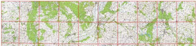
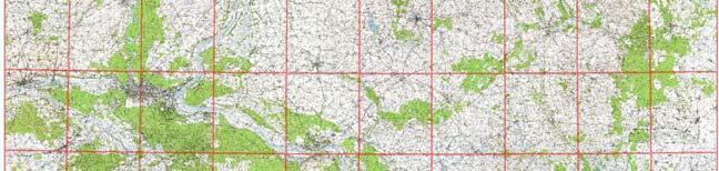
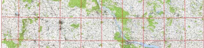
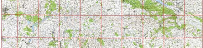
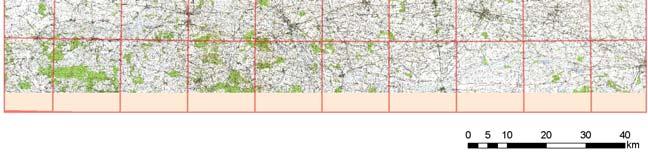
8 Topographic maps Orthophotomaps Basic topographic maps at the scale 1: applied to location of sites/boreholes known from archival material and publications. Orthophotomaps at the scale 1: applied to detail identification of land cover and analysis of topolineaments.

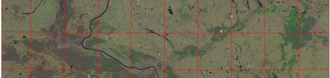
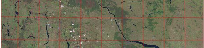
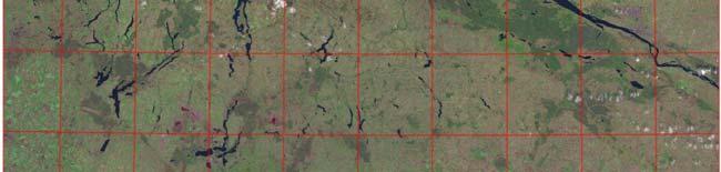
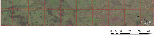
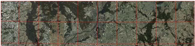
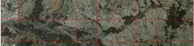
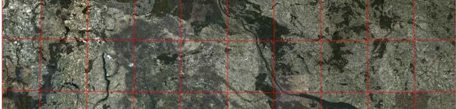
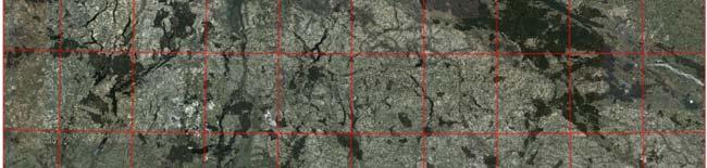
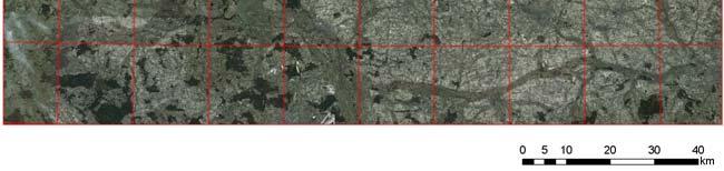
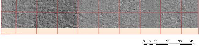
9 Satellite images Multi-spectral images (satellite Landsat 7) Multi-spectral images (satellite Quickbird) Satellite images were applied to the analysis of topolineaments and verification of lineaments distinguished on the other images and DEM.
 Degital Elevation Model, DTED Level 2 (1:50 000) resolution up")
10 DEM Degital Elevation Model, DTED Level 1 (1: ) low-resolution ( m) Degital Elevation Model, DTED Level 2 (1:50 000) resolution up to 25 m
11 The basic DEM at the scale 1 : used to the analysis of glacial landforms in detail; high-resolution (up to 15 m). Note of a broad trough-shaped depression in central part of the area. This is a low till plain relief representing the bed of the former Vistula ice stream lobe.


")

12 GMP Geological Map of Poland at the scale 1: applied to the general recognition of geological structure in the area. Detailed Geological Map of Poland at the scale 1: (published sheets and available archival material) applied to study geological structure and glacial landforms in detail.

13 Collected bore-holes applied to the analysis of geological structure of the study area. Pleistocene Substratum An example of 380 bore-holes set from the one DGMP sheet prepared for statistical analysis of potential number of Weichselian till sheets.
14 Collected geomorphological maps at the scale 1: (appendices to DGMP shets), which were applied to the study morphology, morphometry and origin of glacial landscape in the area.
15 The map of glacial landforms Legend accumulative end moraines thrust end moraines ice-contact marginal landforms hummocky moraines tunnel valleys marginal valleys and channels eskers crevasse-filling landforms kames erosional glacial depressions the maximum limit of the Late Weichselian glaciation lakes rivers, creeks the DGMP sheet An example of ArcGIS cataloguing of glacial landforms prepared for the geospatial analysis in the study area.
16 Elongated landforms Red arrows shows elongated landforms which can interpret as a signature of fast ice flow.


17 Research localities Site type exposure exposure and drilling bore-hole the maximum limit of the Late Weichselian glaciation borders of regions 98 research sites Research at sites sites investigated by authors of the project sites known from the literature sites known from the literature and studied by authors the maximum limit of the Late Weichselian glaciation borders of regions 61 sites studied by authors of the project (included 18 sites previously studied and known from publications), 37 sites sites known from the literature and archival sources


18 Research localities Weichselian tills two tills one till lack till research site the maximum limit of the Late Weichselian glaciation borders of regions The one Wiechselian till occurs at more than 60% all research sites OSL/TL dating sites with OSL/TL dates lack of OSL/TL dating the maximum limit of the Late Weichselian glaciation borders of regions Absolute dating of inter-till sediments (mainly OSL/TL method). 37 form 98 studied sites have OSL/TL dates coming from different sources.
19 Aggregation of stratigraphic data Wysota et al., 2009 (modified)


20 Till fabric Palaeocurrents An example of sedimentological studies The site Nieszawa Late Weichselian tills Striae Late Saalian till Faceted boulders with striae at the base of Weichselian tills. (Molewski, 2007)


21 An example of sedimentological studies The site Nieszawa The upper Late Weichseian till The lower Late Weichseian till Sand wedges developed within the lower Weichselian till. The wedges have been deformed subglacially during ice sheet re-advance.


22 Sampling An example of sedimentological studies The site Obórki Late Weichselian till Fluvio-periglacial sediments Late Saalian till reworked by periglacial processes OSL ages 17.3 ka 27.1 ka 19.4 ka Glaciotectonically deformed sands and gravels 222 ka 272 ka Ventifacts lag Late Saalian till Ventifacts lag Late Saalian till Narloch et al., 2010 (in preparation)
, crushed grains, turbate structures (circular arrangement of grains), and grain")
23 An example of sedimentological studies The site Obórki Textural and petrographical data in the till succession. Microstructures distinguished in thin sections analysis: grain stacks (strings of at least four bridged grains), crushed grains, turbate structures (circular arrangement of grains), and grain lineations (microshears marked by alignments of elongated grains) Narloch et al., 2010 (in preparation)
24 The scenario of ice advances The extents of two ice advances in the Vistula ice lobe area during the Late Weichselian. Main ice flow directions in the Poznań re-advance have been based on till fabric, striae, ploughing marks, sub-till deformations. Wysota et al., 2009 (modified)
25 The scenario of ice advances Time-distance diagram (N-S) North South Wysota et al., 2009 (modified)
26 Conclusins The Vistula lobe area experienced two ice advances of varied extent during the Late Weichselian: the older one during the Leszno=Brandenburg Phase (~20.5 ka) and the younger one in the Poznań=Frankfurt Phase (~18.5 ka). Significant ice sheet retreat was followed by an ice re-advance during the Poznań Phase, overriding the extent of the Leszno Phase. Collected sedimentological and geomorphological data suggest fast ice flow, which was related with previously suggested the ice stream. It is supposed this palaeo-ice stream was mainly active during the Poznań Phase re-advance. The Vistula lobe, which at that time developed at the ice sheet margin, was a terrestrial termination of the ice stream.
27 Thank you for attention!
QUATERNARY AND GLACIAL GEOLOGY
 QUATERNARY AND GLACIAL GEOLOGY JURGEN EHLERS Geologisches Landesamt, Germany Translated from Allgemeine und historische Quartdrgeologie English version by Philip L. Gibbard JOHN WILEY & SONS Chichester
Glacial processes and landforms NGEA01, 2014
 Glacial processes and landforms NGEA01, 2014 Cecilia Akselsson Department of Physical Geography and Ecosystem Science Lund University Geomorphological processes and landforms all over the world Periglacial
Michigan s Geology and Groundwater
 Michigan s Geology and Groundwater Ralph J. Haefner Deputy Director U.S. Geological Survey Michigan-Ohio Water Science Center Lansing, Michigan Outline About the USGS Geology 101 Michigan s geology Bedrock
PHYSICAL GEOGRAPHY. By Brett Lucas
 PHYSICAL GEOGRAPHY By Brett Lucas GLACIAL PROCESSES Glacial Processes The Impact of Glaciers on the Landscape Glaciations Past and Present Types of Glaciers Glacier Formation and Movement The Effects of
Chapter 5: Glaciers and Deserts
 I. Glaciers and Glaciation Chapter 5: Glaciers and Deserts A. A thick mass of ice that forms over land from the compaction and recrystallization of snow and shows evidence of past or present flow B. Types
Page 1. Name:
 Name: 1) Which property would best distinguish sediment deposited by a river from sediment deposited by a glacier? thickness of sediment layers age of fossils found in the sediment mineral composition
Glaciers. (Shaping Earth s Surface, Part 6) Science 330 Summer 2005
 Science 330 Summer 2005") Glaciers (Shaping Earth s Surface, Part 6) Science 330 Summer 2005 1 Glaciers Glaciers are parts of two basic cycles Hydrologic cycle Rock cycle Glacier a thick mass of ice that originates on land from
Glaciers (Shaping Earth s Surface, Part 6) Science 330 Summer 2005 1 Glaciers Glaciers are parts of two basic cycles Hydrologic cycle Rock cycle Glacier a thick mass of ice that originates on land from
Glaciers Earth 9th Edition Chapter 18 Glaciers: summary in haiku form Key Concepts Glaciers Glaciers Glaciers Glaciers
 1 2 3 4 5 6 7 8 9 10 11 12 13 14 Earth 9 th Edition Chapter 18 : summary in haiku form Ten thousand years thence big glaciers began to melt - called "global warming." Key Concepts and types of glaciers.
T. Perron Glaciers 1. Glaciers
 T. Perron 12.001 Glaciers 1 Glaciers I. Why study glaciers? [PPT: Perito Moreno glacier, Argentina] Role in freshwater budget o Fraction of earth s water that is fresh (non-saline): 3% o Fraction of earth
Lowland Glaciation North Wales
 Lowland Glaciation North Wales Background Although there have been many glaciations and advances in ice, the most significant for this are was the Dimlington Stadial which was a period of glacial advance
Lecture Outlines PowerPoint. Chapter 6 Earth Science 11e Tarbuck/Lutgens
 Lecture Outlines PowerPoint Chapter 6 Earth Science 11e Tarbuck/Lutgens 2006 Pearson Prentice Hall This work is protected by United States copyright laws and is provided solely for the use of instructors
4. What type of glacier forms in a sloping valley between rock walls? a. firn glacier b. ice sheet c. cirque d. alpine glacier
 Multiple Choice Questions 1. The term means the loss of snow and ice by evaporation and melting. a. sublimation b. ablation c. erosion d. abrasion 2. What condition must be met for a glacier to begin flowing
The Geology of Sebago Lake State Park
 Maine Geologic Facts and Localities September, 2002 43 55 17.46 N, 70 34 13.07 W Text by Robert Johnston, Department of Agriculture, Conservation & Forestry 1 Map by Robert Johnston Introduction Sebago
Ice Sheets and Late Quaternary Environmental Change
 Ice Sheets and Late Quaternary Environmental Change Martin J. Siegert Bristol Glaciology Centre, School of Geographical Sciences University of Bristol JOHN WILEY & SONS, LTD Chichester New York Weinheim
GEOL.3250 Geology for Engineers Glacial Geology
 GEOL.3250 Geology for Engineers Glacial Geology NAME Part I: Continental Glaciation Continental glaciers are large ice sheets that cover substantial portions of the land area. In the region of accumulation
CARD #1 The Shape of the Land: Effects of Crustal Tilting
 CARD #1 The Shape of the Land: Effects of Crustal Tilting When we look at a birds-eye view of the Great Lakes, it is easy to assume the lakes are all at a similar elevation, but viewed in this way, we
Infilled Kettle Hole, Easton, Aroostook County, Maine
 Maine Geologic Facts and Localities June, 1997, Maine 46 41 26.40 N, 67 48 35.74 W Text by Tom Weddle, Department of Agriculture, Conservation & Forestry 1 Introduction As the last continental glacier
Lecture 10 Glaciers and glaciation
 Lecture 10 Glaciers and glaciation Outline Importance of ice to people! Basics of glaciers formation, classification, mechanisms of movement Glacial landscapes erosion and deposition by glaciers and the
Supplementary Fig. 1. Locations of thinning transects and photos of example samples. Mt Suess/Gondola Ridge transects extended metres above
 Supplementary Fig. 1. Locations of thinning transects and photos of example samples. Mt Suess/Gondola Ridge transects extended 260 24 metres above the modern surface of Mackay Glacier, and included 16
Prentice Hall EARTH SCIENCE
 Prentice Hall EARTH SCIENCE Tarbuck Lutgens Chapter 7 Glaciers, Desert, and Wind 7.1 Glaciers Types of Glaciers A glacier is a thick ice mass that forms above the snowline over hundreds or thousands of
THE ACTION OF GLACIERS
 Surface processes THE ACTION OF GLACIERS Glaciers are enormous masses of ice which are formed due to accumulation, compaction and re-crystallisation of the snow deposited in very cold regions (the majority
Site 4.7. Thornhill Drumlin Jane K. Hart
 Site 4.7. Thornhill Drumlin Jane K. Hart Introduction The drumlins in the West of Ireland represent some of the best exposured features in the whole of Britain and Ireland, and have been studied by numerous
Which landscape best represents the shape of the valleys occupied by glaciers? A) B) C) D)
 B) C) D)") 1. Glaciers often form parallel scratches and grooves in bedrock because glaciers A) deposit sediment in unsorted piles B) deposit rounded sand in V-shaped valleys C) continually melt and refreeze D) drag
1. Glaciers often form parallel scratches and grooves in bedrock because glaciers A) deposit sediment in unsorted piles B) deposit rounded sand in V-shaped valleys C) continually melt and refreeze D) drag
Landscape. Review Note Cards
 Landscape Review Note Cards Last Ice Age Pleistocene Epoch that occurred about 22,000 Years ago Glacier A large, long lasting mass of ice which forms on land and moves downhill because of gravity. Continental
Glacial Modification of Terrain
 Glacial Modification Part I Stupendous glaciers and crystal snowflakes -- every form of animate or inanimate existence leaves its impress upon the soul of man. 1 -Orison Swett Marden Glacial Modification
Reconstructing the Groundwater Flow in the Baltic Basin During the Last Glaciation
 ESF projekts Starpnozaru zinātnieku grupas un modeļu sistēmas izveide pazemes ūdeņu pētījumiem Reconstructing the Groundwater Flow in the Baltic Basin During the Last Glaciation Tomas Saks, Juris Seņņikovs,
Chapter 2. Wearing Down Landforms: Rivers and Ice. Physical Weathering
 Chapter 2 Wearing Down Landforms: Rivers and Ice Physical Weathering Weathering vs. Erosion Weathering is the breakdown of rock and minerals. Erosion is a two fold process that starts with 1) breakdown
Glaciers form wherever snow and ice can accumulate High latitudes High mountains at low latitudes Ice temperatures vary among glaciers Warm
 The Cryosphere Glaciers form wherever snow and ice can accumulate High latitudes High mountains at low latitudes Ice temperatures vary among glaciers Warm (temperate) glaciers: at pressure melting point,
,Baynes Lake. TO...?&.?...A 2...KO.?'!!&... Sr. *logical Engineer
 > i evernment OF BRITISH COLUMBIA a TO...?&.?...A 2....KO.?'!!&... Sr. *logical Engineer... Grou,,water. Section Hydrology Division Wat.er... In~.~s.tiga.ti.On.s..Branck.... 5 u BJECT...C;.roun.dw.ater...Snve
Name: Mid-Year Review #2 SAR
 Name: Mid-Year Review #2 SAR Base your answers to questions 1 through 3 on on the diagram below, which shows laboratory materials used for an investigation of the effects of sediment size on permeability,
How do glaciers form?
 Glaciers What is a Glacier? A large mass of moving ice that exists year round is called a glacier. Glaciers are formed when snowfall exceeds snow melt year after year Snow and ice remain on the ground
4 Formation of glacial ice 3. 5 Formation of glacial ice (cont.) 3. 6 Glacier economy and general flow structure 4
 3. 6 Glacier economy and general flow structure 4") Contents 1 Glacier Flow 2 2 Definition 2 3 Amount 3 4 Formation of glacial ice 3 5 Formation of glacial ice (cont.) 3 6 Glacier economy and general flow structure 4 7 Example 5 8 Examples 6 9 Ice movement
Contents 1 Glacier Flow 2 2 Definition 2 3 Amount 3 4 Formation of glacial ice 3 5 Formation of glacial ice (cont.) 3 6 Glacier economy and general flow structure 4 7 Example 5 8 Examples 6 9 Ice movement
Chapter 2. Denudation: Rivers and Ice
 Chapter 2. Denudation: Rivers and Ice DENUDATION: process that lowers level of land - caused by rivers, glaciers, waves & wind - involves processes of WEATHERING & EROSION Weathering Def: breakdown of
Introduction to the Special Issue on Glacial Geology and Geomorphology
 Journal of Maps, 2006, i-v Introduction to the Special Issue on Glacial Geology and Geomorphology CHRIS D. CLARK Department of Geography, University of Sheffield, Sheffield, S10 2TN, UK; c.clark@sheffield.ac.uk
Lecture Outline Lecture Outline Monday April 9-16, 2018 Questions? Announcements:
 Lecture Outline Lecture Outline Monday April 9-16, 2018 Questions? Announcements: Geology 101 Night Video: The Day After Tomorrow Hollywood disaster movie about the onset of a glacial period When: Monday
INDEX_Glaciers.pdf. mountain (alpine) glacier NLG Test bank: [Glaciers01-03.jpg] High Quality: [Moraine_med-lat_Haines_AK_.jpg]
![INDEX_Glaciers.pdf. mountain (alpine) glacier NLG Test bank: [Glaciers01-03.jpg] High Quality: [Moraine_med-lat_Haines_AK_.jpg]](/thumbs/83/88580835.jpg "INDEX_Glaciers.pdf. mountain (alpine) glacier NLG Test bank: [Glaciers01-03.jpg] High Quality: [Moraine_med-lat_Haines_AK_.jpg]") Glaciers_INDEX.pdf This is an index of all terms/ideas in this question bank. Question banks are organized into topics containing related terms/ideas. Each term/idea has at least one related question,
Glaciers_INDEX.pdf This is an index of all terms/ideas in this question bank. Question banks are organized into topics containing related terms/ideas. Each term/idea has at least one related question,
Investigating Glacial Landscape Systems 3 days
 AS Level Geography OCR Investigating Glacial Landscape Systems 3 days Deliver two full days of fieldwork within an inspiring physical environment. Prepare AS level students for the Paper 1: Landscape and
What is a Glacier? Types of Glaciers
 Alpine & Continental Glaciers Glacial Mass Balance Glacial Ice Formation Glacial Movement & Erosion Erosional and Depositional Landforms The Pleistocene Epoch Geomorphology of SW Manitoba Chapter 17 1
OBSERVATIONS OF PERMAFROST-LANDSCAPE DYNAMICS RELATED TO ANTHROPOGENIC DISTURBANCES, YUKECHI STUDY SITE, CENTRAL YAKUTIA
 OBSERVATIONS OF PERMAFROST-LANDSCAPE DYNAMICS RELATED TO ANTHROPOGENIC DISTURBANCES, YUKECHI STUDY SITE, CENTRAL YAKUTIA A.N. Fedorov, P.Ya. Konstantinov, I.S. Vassiliev, N.P. Bosikov, Ya.I. Torgovkin,
Topic 2: Landscape Systems, Processes and Change
 Topic 2: Landscape Systems, Processes and Change Option 2A: Glaciated Landscapes and Change Overview Ice sheets and glaciers operate within a landscape system as glacial processes of erosion, transport
mountain rivers fixed channel boundaries (bedrock banks and bed) high transport capacity low storage input output
 high transport capacity low storage input output") mountain rivers fixed channel boundaries (bedrock banks and bed) high transport capacity low storage input output strong interaction between streams & hillslopes Sediment Budgets for Mountain Rivers Little
mountain rivers fixed channel boundaries (bedrock banks and bed) high transport capacity low storage input output strong interaction between streams & hillslopes Sediment Budgets for Mountain Rivers Little
Clast fabric in a Stony Brook campus moraine: Testing models for the process of glacial lobe dynamics
 Clast fabric in a Stony Brook campus moraine: Testing models for the process of glacial lobe dynamics Jennifer DePaoli, Charles Regulinski, Josh Timlin, Dan Davis and Elliot Klein Department of Geosciences
The syllabus was approved by Study programmes board, Faculty of Science on to be valid from , autumn semester 2016.
 Faculty of Science GEON05, Quaternary Geology: Glacial Sedimentology - Processes, Sediments and Landform Systems, 15 credits Kvartärgeologi: Glacial sedimentologi - processer, sediment och landformssystem,
Tomas Saks, ĢZZF. ESF projekts Starpnozaru zinātnieku grupas un modeļu sistēmas izveide pazemes ūdeņu pētījumiem
 ESF projekts Starpnozaru zinātnieku grupas un modeļu sistēmas izveide pazemes ūdeņu pētījumiem Modelling the influence of the Pleistocene glaciatiations on the groundwater flow in the Baltic Basin Pleistocēna
NDWRCDP Disclaimer This work was supported by the National Decentralized Water Resources Capacity Development Project (NDWRCDP) with funding provided
 with funding provided") Glacial Landforms NDWRCDP Disclaimer This work was supported by the National Decentralized Water Resources Capacity Development Project (NDWRCDP) with funding provided by the U.S. Environmental Protection
Glacial Landforms NDWRCDP Disclaimer This work was supported by the National Decentralized Water Resources Capacity Development Project (NDWRCDP) with funding provided by the U.S. Environmental Protection
BLAKENEY ESKER AND HOW IT FORMED. The Blakeney Esker is a ridge, around 3.5 km in length, which runs southeastwards
 BLAKENEY ESKER AND HOW IT FORMED Introduction The Blakeney Esker is a ridge, around 3.5 km in length, which runs southeastwards from west of Blakeney, to Wiveton Downs, north-west of Glandford, in north
Foundations of Earth Science, 6e Lutgens, Tarbuck, & Tasa
 Foundations of Earth Science, 6e Lutgens, Tarbuck, & Tasa Glacial and Arid Landscapes Foundations, 6e - Chapter 4 Stan Hatfield Southwestern Illinois College Glaciers Glaciers are parts of two basic cycles
Evidence for Permafrost on Long Island
 Evidence for Permafrost on Long Island By Vesna Kundic and Gilbert N. Hanson Department of Geosciences Stony Brook University Permafrost or permanently frozen ground is soil or rock that remains below
STOP 15: Morphology and internal structure of a ribbed moraine and drumlin remnant in the environs of Baldone, Central Latvian Lowland
 STOP 15: Morphology and internal structure of a ribbed moraine and drumlin remnant in the environs of Baldone, Central Latvian Lowland Kristaps Lamsters and Vitālijs Zelčs Mašēni and Aizvējas are two sand
Science Olympiad Dynamic Earth: Glaciers
 Science Olympiad Dynamic Earth: Glaciers Write the appropriate response next to the corresponding number on the answer sheet. 1. Name 2 aspects of a glacier that define it as such (questions #1-2, 1 point
Remote sensing and GIS-based analysis of past frost-wedge polygons
 Remote sensing and GIS-based analysis of past frost-wedge polygons Marek Ewertowski 1,2, Andrzej Kijowski 2, Marcin Słowik 2 1 Durham University, Department of Geography, Science Laboratories, South Road,
Evidence of Ice Retreat, East Shore of Sabattus Pond
 Maine Geologic Facts and Localities November, 2002 Evidence of Ice Retreat, East Shore of Sabattus Pond 44 7 25.14 N, 70 5 21.69 W Text by Michael E. Foley, Department of Agriculture, Conservation & Forestry
Bank - An Analog for Carbonate Sand Reservoirs*
 PS Satellite Imagery and Geological Interpretation of the Exumas, Great Bahama Bank - An Analog for Carbonate Sand Reservoirs* Paul (Mitch) Harris 1 and James Ellis 2 Search and Discovery Article #50200
RIVERS, GROUNDWATER, AND GLACIERS
 RIVERS, GROUNDWATER, AND GLACIERS Delta A fan-shaped deposit that forms when a river flows into a quiet or large body of water, such as a lake, an ocean, or an inland sea. Alluvial Fan A sloping triangle
LONG ISLAND CLAST ORIENTATIONS
 LONG ISLAND CLAST ORIENTATIONS AND WHAT THEY TILL US Elliot Klein and Dan Davis Department of Geosciences, State University of New York at Stony Brook, 11794 Long Island glacigenic surface deposits, where
Geology and New England Landscapes
 Geology and New England Landscapes Jim Turenne, CPSS USDA-NRCS Warwick, RI. http://nesoil.com Why Geology? Provides the big picture of site conditions. Major part of soil formation (parent material and
Lecture 21: Glaciers and Paleoclimate Read: Chapter 15 Homework due Thursday Nov. 12. What we ll learn today:! Learning Objectives (LO)
") Learning Objectives (LO) Lecture 21: Glaciers and Paleoclimate Read: Chapter 15 Homework due Thursday Nov. 12 What we ll learn today:! 1. 1. Glaciers and where they occur! 2. 2. Compare depositional and
Learning Objectives (LO) Lecture 21: Glaciers and Paleoclimate Read: Chapter 15 Homework due Thursday Nov. 12 What we ll learn today:! 1. 1. Glaciers and where they occur! 2. 2. Compare depositional and
SAMPLE PAGE. pulses. The Ice Age By: Sue Peterson
 Page 61 Objective sight words (pulses, intermittent, isotopes, chronicle, methane, tectonic plates, volcanism, configurations, land-locked, erratic); concepts (geological evidence and specific terminology
Name: Class: Date: Multiple Choice Identify the letter of the choice that best completes the statement or answers the question.
 Name: Class: Date: geology ch 7 test 2008 Multiple Choice Identify the letter of the choice that best completes the statement or answers the question. 1. Which of the following is true about ice sheets?
Geological control in 3D stratigraphic modeling, Oak Ridges Moraine, southern Ontario. Logan, C., Russell, H. A. J., and Sharpe, D. R.
 Geological control in 3D stratigraphic modeling, Oak Ridges Moraine, southern Ontario Logan, C., Russell, H. A. J., and Sharpe, D. R. Rationale Increasing urbanization in the Greater Toronto Area is creating
Maximum Extent of Pleistocene Glaciation - 1/3 of land surface Most recent glacial maximum peaked 18,000 years ago and is considered to have ended
 Glaciers Maximum Extent of Pleistocene Glaciation - 1/3 of land surface Most recent glacial maximum peaked 18,000 years ago and is considered to have ended 10,000 B.P. Current Extent of Glaciation - about
Resume components. Assignments due Monday. Shape of Puget Sound. Formation and bathymetry
 Assignments due Monday Resume Top four choices of projects, in order of preference One paragraph proposal about topic of choice Weekly schedule Topics you d like to cover in class Math: Complete the calculus
Surficial Geology of Antioch Quadrangle
 Illinois Preliminary Geologic Map IPGM Antioch-SG Surficial Geology of Antioch Quadrangle Lake County, Illinois and Kenosha County, Wisconsin Andrew J. Stumpf and Michael L. Barnhardt 2005 Department of
4. The map below shows a meandering stream. Points A, B, C, and D represent locations along the stream bottom.
 1. Sediment is deposited as a river enters a lake because the A) velocity of the river decreases B) force of gravity decreases C) volume of water increases D) slope of the river increases 2. Which diagram
Landscape evolution. An Anthropic landscape is the landscape modified by humans for their activities and life
 Landforms Landscape evolution A Natural landscape is the original landscape that exists before it is acted upon by human culture. An Anthropic landscape is the landscape modified by humans for their activities
Moosehead Lake and the Tale of Two Rivers
 Maine Geologic Facts and Localities June, 2005 45 o 53 5.09 N, 69 o 42 14.54 W Text by Kelley, A.R.; Kelley, J.T.; Belknap, D.F.; and Gontz, A.M. Department of Earth Sciences, University of Maine, Orono,
Areal Scour vs. Selective Linear Erosion
 Erosional Forms and Landscapes Erosional Landscapes Areal Scour vs. Selective Linear Erosion Cirques Form and Morphology Many Forms Red Tarn Cirque Basin English Lake District Red Tarn Cirque Basin, English
Timing and magnitude of late Pleistocene and Holocene glaciations in Yosemite National Park
 National Park Service U.S. Department of the Interior Yosemite National Park Timing and magnitude of late Pleistocene and Holocene glaciations in Yosemite National Park Greg Stock Yosemite National Park
PROMISED LAND STATE PARK PIKE COUNTY ANCIENT RIVERS AND AGES OF ICE
 PENNSYLVANIA TRAIL OF GEOLOGY PARK GUIDE 18 PROMISED LAND STATE PARK PIKE COUNTY ANCIENT RIVERS AND AGES OF ICE Promised Land State Park is located on a broad upland surface known as the Pocono Plateau.
Source- to- Sink in the Stra/graphic Record
 Source- to- Sink in the Stra/graphic Record Capturing the Long-Term, Deep-Time Evolution of Sedimentary Systems Stephan A. Graham Stanford University Brian W. Romans Chevron Energy Technology Co. Jacob
Landscape Systems: Glaciation 3 days
 AS Level Geography Edexcel Landscape Systems: Glaciation 3 days Deliver two days of fieldwork within an inspiring physical environment covering all the recommended themes in depth. Prepare AS level students
IGMAC 2015: Surficial Geologic Mapping STATEMAP past and future. Valparaiso Moraine, Will County
 IGMAC 2015: Surficial Geologic Mapping STATEMAP past and future Valparaiso Moraine, Will County presented by Drew Phillips, September 10. 2015 SURFICIAL MAPPING Completed Aug 2015 NE Illinois Project:
DATA ANALYSIS AND INTERPRETATION
 III. DATA ANALYSIS AND INTERPRETATION 3.1. Rift Geometry Identification Based on recent analysis of modern and ancient rifts, many previous workers concluded that the basic structural unit of continental
Detailed structure of buried glacial landforms revealed by high-resolution 3D seismic data in the SW Barents Sea
 Detailed structure of buried glacial landforms revealed by high-resolution 3D seismic data in the SW Barents Sea Benjamin Bellwald 1, Sverre Planke 1,2, Stéphane Polteau 1, Nina Lebedova-Ivanova 1, Amer
2/23/2009. Visualizing Earth Science. Chapter Overview. Deserts and Drylands. Glaciers and Ice Sheets
 Visualizing Earth Science By Z. Merali and B. F. Skinner Chapter 6 Deserts, Glaciers and Ice Sheets Chapter Overview Deserts and Drylands Glaciers and Ice Sheets Deserts Geography Categorization of deserts
LANDSCAPE BOUNDARIES BELTS OR LINES? EXAMPLES FROM SOUTHERN AND NORTHERN POLAND
 LANDSCAPE BOUNDARIES BELTS OR LINES?... 19 Sylwia Kulczyk LANDSCAPE BOUNDARIES BELTS OR LINES? EXAMPLES FROM SOUTHERN AND NORTHERN POLAND Abstract: The problem of width of landscape boundary remains widely
MASS MOVEMENTS, WIND, AND GLACIERS
 Date Period Name MASS MOVEMENTS, WIND, AND GLACIERS SECTION.1 Mass Movements In your textbook, read about mass movements. Use each of the terms below just once to complete the passage. avalanche creep
Dynamics of surging tidewater glaciers in Tempelfjorden Spitsbergen
 Department of Physical Geography and Quaternary Geology Dynamics of surging tidewater glaciers in Tempelfjorden Spitsbergen Anne Flink Master s thesis Physical Geography and Quaternary Geology, 60 Credits
Bell Ringer. Are soil and dirt the same material? In your explanation be sure to talk about plants.
 Bell Ringer Are soil and dirt the same material? In your explanation be sure to talk about plants. 5.3 Mass Movements Triggers of Mass Movements The transfer of rock and soil downslope due to gravity is
W eichselian climate change and impact on aeolian and fluvial periglacial environments in the Twente area, Lutterzand type locality
 Excursion Guide INTIMATE 28 march 2012 W eichselian climate change and impact on aeolian and fluvial periglacial environments in the Twente area, Lutterzand type locality C. Kasse F acuity of Earth and
1. Any process that causes rock to crack or break into pieces is called physical weathering. Initial product = final product
 Weathering 1. Any process that causes rock to crack or break into pieces is called physical weathering. Initial product = final product End Result of physical weathering is increased surface area. 2. Physical
Guided Notes Surface Processes. Erosion & Deposition By: Glaciers
 Guided Notes Surface Processes Erosion & Deposition By: Glaciers K. Coder 2015 26) How does moving ice erode and deposit sediments? Glaciers (Movement of Ice): a naturally formed mass of ice and snow that
Lake Levels and Climate Change in Maine and Eastern North America during the last 12,000 years
 Maine Geologic Facts and Localities December, 2000 Lake Levels and Climate Change in Maine and Eastern North America during the last 12,000 years Text by Robert A. Johnston, Department of Agriculture,
Mass Movements, Wind, and Glaciers
 Mass Movements,, and Glaciers SECTION 8.1 Mass Movement at Earth s Surface In your textbook, read about mass movement. Use each of the terms below just once to complete the passage. avalanche creep landslide
THE JUAN DE FUCA LOBE OF THE CORDILLERAN ICE SHEET
 THE JUAN DE FUCA LOBE OF THE CORDILLERAN ICE SHEET There were two large glaciers in western Washington during the latest, or Vashon, glaciation of that region. Each was essentially an elongated lobe of
 Page 1 of 9 Name: Base your answer to the question on the diagram below. The arrows show the direction in which sediment is being transported along the shoreline. A barrier beach has formed, creating a
Pre-Lab Reading Questions ES202
 ES202 The are designed to encourage students to read lab material prior to attending class during any given week. Reading the weekly lab prior to attending class will result in better grade performance
Paradoxes of Fluvial Evolution in Young Orogenic Systems
 Journal of Indian Geomorphology Volume 5, 2017 ISSN 2320-0731 Indian Institute of Geomorphologists (IGI) Paradoxes of Fluvial Evolution in Young Orogenic Systems Leszek Starkel Department of Geoenvironmental
The boulder was most likely moved to this location by A) glacial ice B) prevailing wind C) streamfiow D) volcanic action
 glacial ice B) prevailing wind C) streamfiow D) volcanic action") 1. Which rock material was most likely transported to its present location by a glacier? A) rounded sand grains found in a river delta B) rounded grains found in a sand dune C) residual soil found on a
1. Which rock material was most likely transported to its present location by a glacier? A) rounded sand grains found in a river delta B) rounded grains found in a sand dune C) residual soil found on a
4.3. Geomorphologic route along the Urasalakh River
 The Expedition Lena-Anabar 2003 4 Periglacial studies around Cape Mamontov Klyk 4.3. Geomorphologic route along the Urasalakh River Dimitri Bolshiyanov and Alexander Makarov 4.3.1 Structure of Quaternary
STABLE ISOTOPES AS RECORD OF CLIMATIC CHANGES OF DANIGLACIAL IN LITHUANIA
 GEOCHRONOMETRIA Vol. 20, pp 81-86, 2001 Journal on Methods and Applications of Absolute Chronology STABLE ISOTOPES AS RECORD OF CLIMATIC CHANGES OF DANIGLACIAL IN LITHUANIA ALGIRDAS GAIGALAS 1, ANNA PAZDUR
Extra Credit Assignment (Chapters 4, 5, 6, and 10)
") GEOLOGY 306 Laboratory Instructor: TERRY J. BOROUGHS NAME: Extra Credit Assignment (Chapters 4, 5, 6, and 10) For this assignment you will require: a calculator and metric ruler. Chapter 4 Objectives:
GEOLOGY 306 Laboratory Instructor: TERRY J. BOROUGHS NAME: Extra Credit Assignment (Chapters 4, 5, 6, and 10) For this assignment you will require: a calculator and metric ruler. Chapter 4 Objectives:
Diagnostic Geomorphic Methods for Understanding Future Behavior of Lake Superior Streams What Have We Learned in Two Decades?
 Diagnostic Geomorphic Methods for Understanding Future Behavior of Lake Superior Streams What Have We Learned in Two Decades? Faith Fitzpatrick USGS WI Water Science Center, Middleton, WI fafitzpa@usgs.gov
Surficial Geologic Mapping Proposal for STATEMAP FY2019
 Surficial Geologic Mapping Proposal for STATEMAP FY2019 presented by David Grimley Illinois State Geological Survey Prairie Research Institute, University of Illinois IGMAC meeting, September 6 th, 2018
The Palmer Hill Glacial-Marine Delta, Whitefield, Maine
 Maine Geologic Facts and Localities December, 2010, Maine 44 o 10 12.16 N, 69 o 37 18.93 W Text by Woodrow Thompson, Department of Agriculture, Conservation & Forestry 1 Introduction The most recent continental
Name: Which rock layers appear to be most resistant to weathering? A) A, C, and E B) B and D
 A, C, and E B) B and D") Name: 1) The formation of soil is primarily the result of A) stream deposition and runoff B) precipitation and wind erosion C) stream erosion and mass movement D) weathering and biological activity 2)
Name: 1) The formation of soil is primarily the result of A) stream deposition and runoff B) precipitation and wind erosion C) stream erosion and mass movement D) weathering and biological activity 2)
Amazing Ice: Glaciers and Ice Ages
 Amazing Ice: Glaciers and Ice Ages Updated by: Rick Oches, Professor of Geology & Environmental Sciences Bentley University Waltham, Massachusetts Based on slides prepared by: Ronald L. Parker, Senior
Buried-valley Aquifers: Delineation and Characterization from Reflection Seismic and Core Data at Caledon East, Ontario
 Buried-valley Aquifers: Delineation and Characterization from Reflection Seismic and Core Data at Caledon East, Ontario Russell, H.A.J. 1, S.E. Pullan 1, J.A. Hunter 1, D.R. Sharpe 1, and S. Holysh 2 1
Loess and dust. Jonathan A. Holmes Environmental Change Research Centre
 Loess and dust Jonathan A. Holmes Environmental Change Research Centre Why is dust important? Mineral dust is an important constituent of the solid load in Earth's atmosphere, the total atmospheric aerosol
Holocene Lower Mississippi River Avulsions: Autogenic Versus Allogenic Forcing*
 Holocene Lower Mississippi River Avulsions: Autogenic Versus Allogenic Forcing* Eric Prokocki 1,2 Search and Discovery Article #50330 (2010) Posted October 14, 2010 *Adapted from oral presentation at AAPG