BLAKENEY ESKER AND HOW IT FORMED. The Blakeney Esker is a ridge, around 3.5 km in length, which runs southeastwards
|
|
|
- Ashley Waters
- 6 years ago
- Views:
Transcription
. Figure 1 The location of Blakeney.")
1 BLAKENEY ESKER AND HOW IT FORMED Introduction The Blakeney Esker is a ridge, around 3.5 km in length, which runs southeastwards from west of Blakeney, to Wiveton Downs, north-west of Glandford, in north Norfolk, UK (Figure 1). Figure 1 The location of Blakeney. There are several near right-angle bends in the esker. The northern section of the ridge between Morston Downs and Kettlehill Plantation has a sharp, well-defined shape. It is between 40 and 100 m wide and, in places, rises to around 20 m above the surrounding topography. Further south, the ridge is lower for about 1 km and the sharp ridge is not as obvious. This is due to the removal of aggregate during the early 1940s, used in the construction of nearby Langham Airfield. The ridge forms a prominent feature again towards its southern end at Wiveton Downs (Figure 2), where the ridge surface rises up to 15 m above the surrounding topography, the name Downs is a name often given to ridges or hills. Several small isolated hills, located between Wiveton Downs and 1

2 Glandford, are in line with the esker and may represent the final eroded remnants of the ridge. Figure 2 Sketch map showing the location of Blakeney Esker. The shape of the esker has been simplified. Internal composition of the ridge The name esker, originates form the Irish word eiscir, meaning sandy ridge. An understanding of what the ridge is made of helps us to understand how it formed. The ridge is composed of two units, and these can be seen in some of the quarries that exist along its length. Unit B a sand and gravel, with occasional lenses of till, making up the ridge. Unit A a chalky till that occurs beneath, and adjacent to, the ridge margins. 2
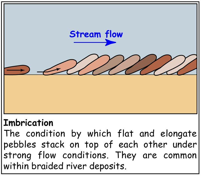
3 Unit A lies beneath the ridge and the surrounding fields. It is a compact, cream-coloured very chalky till (boulder clay) (Explanation Box 1) that contains numerous clasts (pebbles) of chalk and flint. The texture of the till matrix (the material between the clasts that holds the unit together) is very silty, and feels smooth when rubbed between the fingers. This unit is a subglacial lodgement till (Explanation Box 2) which was deposited beneath a glacier. Beneath the ridge, the surface of this unit is not flat, but is cut by a series of channels that run in the same direction as the ridge. These channels have steep sides, are between 15 and 25 m wide, and can be traced for up to 400 m. These channels, which formed beneath the glacier due to the flow of water, are called Nye channels (Explanation Box 3). Unit B infills the Nye channels cut into chalky till (Unit A) and forms most of the ridge. It can have a thickness of up to 15 m. The unit consists of clast-supported (Explanation Box 4) cobble gravels separated by pockets of yellowish orange sand. The main constituent of the cobble gravels is flint and individual clasts are usually very round in shape. This shape suggests that very high-energy turbulent flow conditions existed, causing the edges of the rough cobbles to be broken off and smoothed as they bumped into each another. This process is known as abrasion (Explanation Box 5). The gravels also commonly have a structure called imbrication (Explanation Box 6). This is a useful feature, used by geologists, to understand the direction of water flow. In this case, flow was broadly from the north-west but tends to lie parallel to the trend of 3

4 the landform. Some of the gravel and sand layers, referred to by geologists as beds, also become finer upwards. This means that within an individual bed, the average size of the gravel clasts becomes smaller upwards; likewise within sand beds, the coarseness of the sand reduces upwards. This fining-upward suggests that there were frequent changes in flow velocity and therefore, the flows ability to entrain (carry) and transport different types of material. This is because a reduction in flow velocity means only the lighter material can be carried by the water, causing the heavier material to be deposited. There are occasional lenses of flinty till within Unit B. How the esker formed When we look at the shape (morphology) of the ridge and its internal composition, we can build up a model of how the ridge formed. This helps us to decide whether or not the ridge actually is an esker. Five stages within the ridge s evolution can be identified: 4
.")

5 Stage 1: This stage coincides with the movement of ice across the Blakeney area and the deposition of the chalky till (Unit A). Stage 2: Modification of drainage beneath the glacier and the erosion of Nye channels onto the upper surface of the chalky till by meltwater. Movement of ice is towards the reader. 5

6 Stage 3: Transportation and deposition of coarse sands and gravels within these Nye channels by meltwater (Unit B). Because the channels are beneath the ice they are operating within an enclosed space, which greatly increases the pressure and flow velocity. This explains why the water had the energy to erode channels into the till, and transport high quantities of gravel and cobbles. Stage 4: Enlargement of the Nye channels into a tunnel and its subsequent infilling by meltwater sand, gravel and cobbles (Unit B). The enlargement from channels to a single tunnel can be explained by the frictional melting of ice, driven by the flowing meltwater. This is an example of a positive feedback process. As frictional melting of the ice creates a larger channel that can transport more water, this drives greater frictional melting due to increased water flow and greater surface area of the channel margins. 6

7 The origin of the rare lenses of till within Unit B is not clear, but the most likely explanation is that it was eroded from upstream and carried by the meltwater. Stage 5: Meltwater flow and the deposition of the sands and gravels would have continued until either the source of the meltwater was exhausted, or the drainage pathway was diverted. Later, northwards retreat of the ice margin revealed the ridge. Is the ridge an esker? The shape and internal composition of the ridge reveal that the landform formed by meltwater flow beneath a glacier and is therefore an esker. However, the shape of the esker is slightly different to that of many others, as some sections don t appear to be inline with one another. This offset pattern is commonly associated with crevassing (Explanation Box 7) within the ice. This suggests that during formation, the course of the water was strongly influenced by crevasse patterns that extended through the glacier. 7
.")
8 THE BIGGER PICTURE How other north Norfolk glacial landmarks are related Cromer Ridge The Cromer Ridge (Figure 1) is one of the most prominent landforms in north Norfolk. It forms some of the highest ground within the county and in places rises to over 50 m above surrounding land (over 100 m OD). Figure 1 Cromer ridge from Beeston Bump, just east of Sheringham, looking east. The ridge intersects the east coast between Trimingham and Overstrand, where it can be identified in the cliffs, and traced westwards for 15 km to Sheringham. From Sheringham, the ridge bends towards the southwest and extends for 20 km towards Thursford. A small gap, known to geologists as the Briston Gap, occurs where the ridge is absent (Figure 2). Figure 2 Sketch map showing approximate extent of Cromer Ridge. The coastal cliffs around Trimingham, and several quarries situated on the ridge itself, provide us with a valuable insight into what it is made of 8

9 and its structure. This has shown that the ridge has a very complex history and was formed during several different phases. The bottom 60 m of the ridge comprise beds of pre-existing till and sand, silt and clay, which have been highly deformed when they were pushed southwards by a glacier. Effectively, this bulldozing process is similar to pushing a heavy book over a tablecloth it causes the tablecloth to ruck and fold over upon itself. Smaller scale examples of this occurring in front of glaciers can be found in Iceland today (Explanation Box 8). This is exactly what happened with the glacier pushing into the preexisting sediment pile. An example of this deformation can be seen in the cliffs near Overstrand where blocks of chalk and layers of sand and till have been bulldozed and stacked on top of one-another (Figure 3). Figure 3 The Cromer ridge reaches the coast in the cliffs near Overstrand. The arrow shows the direction in which the glacier pushed the sediment. This part of the ridge is called a push moraine, and it is also a terminal moraine because it marks the maximum extent of the ice. Examples of these can be found at many modern day glaciers, such as in Iceland (Explanation Box 9). The top m of the ridge, overlying the moraine, is composed of sands and gravels and these were laid down as an extensive glacial outwash fan during a later advance. 9
. Such river systems can deposit vast quantities of sand, gravel and cobbles. Two outwash plains are located close to the Blakeney Esker.")
10 Kelling and Salthouse outwash plains An outwash plain or sandur occurs where fans of sediment deposited by meltwater from a glacier margin coalesce to form a braided river channel system that extends across a broad, gently sloping plain (Explanation Box 10). Such river systems can deposit vast quantities of sand, gravel and cobbles. Two outwash plains are located close to the Blakeney Esker. The first of these is called the Salthouse outwash plain and this forms the ground around Salthouse Heath (Figure 4). Just to the east of Salthouse Heath is Kelling Heath, which forms the second, and larger of the outwash plains. Figure 4 The old outwash plain at Salthouse Health today. Kames and terraces Adjacent to the Blakeney Esker and on both sides of the Glaven Valley, are a series of small hills and conical-shaped mounds. These range in 10
11 diameter from 20 to 400 m and can be up to 20 m in height, although most are less than about 10 m. Geologists have interpreted these features as kames and kame terraces. Kames are piles of sand and gravel, which have been laid down at the front of a melting glacier. They grew as the melting glacier deposited sediment. Secondly, a succession of flat terrace features can be found on the western and eastern sides of the Glaven Valley near Glandford. These terraces comprise up to 10 m of outwash sand and gravel with thin layers of chalky till. Geologists have interpreted these features as kame terraces (Explanation Box 12). These features form in contact with, or close to, the sides of a glacier, where glacial meltwater has deposited sand and gravel against the valley sides, forming a series of terrace features when the ice melts. HOW ALL THE LANDFORMS FIT TOGETHER By fitting all of this information together we discover the order in which the features formed, and build a picture of how the geography of the area has evolved in relation to an active ice margin. Five stages of evolution can be recognised, and each stage is illustrated in a series of schematic cartoons showing a planview and cross-sectional view. Stage 1 formation of the Cromer Ridge push moraine (Figure 5) The Cromer Ridge is the first feature that was formed, created by the pushing and stacking of pre-existing sediments at the ice margin to form a push moraine. 11
12 Stage 2 the Cromer Ridge outwash fan (Figure 6) Draped over the top of the Cromer Ridge push moraine is a thick sequence of sands and gravels that form the Cromer Ridge outwash fan. The fact that this fan is superimposed upon the moraine demonstrates that the formation of the outwash fan was after the moraine. The outwash fan itself developed by braided meltwater streams, coming from the ice margin to the north, depositing vast quantities of sand and gravel. The position of individual drainage channels is not known, but examples of modern outwash fans from places such as Iceland, suggest that there were likely to have been a series of smaller fans coming together from drainage points along the ice margin. Stage 3 Kelling outwash plain (Figure 7) Following the deposition of the Cromer Ridge outwash fan, there was a small north-westwards retreat of the glacier margin. The ice margin at this time probably lay along the present northern and western flanks of Kelling Heath as suggested by steep ice-contact slopes. Meltwater draining from the glacier deposited extensive sheets of sand and gravel as part of the Kelling outwash plain, in the present area of Kelling Heath. This constrained meltwater drainage both to the north and south between the glacier and the Cromer Ridge respectively. At some point during this stage, the Cromer Ridge was breached by meltwater in the Briston area forming a drainage outlet to the south, called the Briston Gap. 12
13 Stage 4 Salthouse outwash plain and Blakeney Esker (Figure 8) A further phase of glacier retreat occurred with the ice margin lying along the northern and western edges of Salthouse Heath as indicated by the heath s steep northern and western ice contact slopes. The Blakeney Esker was formed during this stage within a sub-glacial drainage channel that was feeding the Salthouse outwash plain. The kames and kame terraces within the Glaven Valley were probably also formed at this time. This new drainage pattern creates a geomorphological problem that is currently unresolved. The Salthouse outwash plain appears to have been bounded on all sides, either by glacier ice, the Cromer Ridge or the Kelling outwash plain, which is 11 m higher than the Salthouse outwash plain, so where did the outwash drain to? Did it form a lake infront of the glacier? Or perhaps drain through the older permeable Kelling outwash sediments? Stage 5 present day (Figure 9) Following complete deglaciation the landforms of the Blakeney area have experienced surface weathering for several hundred thousand years, during which at least two interglacial warm stages (including the present day) and one further glacial episode are known to have occurred. This, together with gravel quarrying, has resulted in the partial erosion of the landforms, although their surface expression is still evident today and is testament to a very dramatic and significant climatic episode within Norfolk s past. 13

14 Figure 5 Stage 1 formation of the Cromer Ridge push moraine. 14

15 Figure 6 Stage 2 formation of the Cromer Ridge outwash fan. 15

16 Figure 7 Stage 3 Formation of the Kelling outwash plain. 16

17 Figure 8 Stage 4 Formation of Salthouse outwash plain and Blakeney Esker (K = kames and kame terraces). 17

18 Figure 9 Stage 5 present day. 18


19 EXPLANATION BOXES Explanation Box 1 Explanation Box 2 Explanation Box 3 19

20 Explanation Box 4 Explanation Box 5 Explanation Box 6 20

21 Explanation Box 7 Explanation Box 8 21

22 Explanation Box 9 Explanation Box 10 22


23 Explanation Box 11 Explanation Box 12 All figures featured are BGS NERC
24 Discussion points / homework topics 1. Geologists have only just agreed that the ridge is actually an esker. Other ideas included: a. open crevasse filling (filling in of crevasses in the glaciers surface then when ice melts it leaves a ridge of sediment) b. a linear remnant of a larger mass of sand and gravel that has been eroded away c. formation in an ice-marginal environment. How did geologists discount these theories and conclude that it was an esker? ANSWER: The quarrying that revealed the presence of Nye channels in the till surface, is vital. The Nye channels are aligned with the ridge, strongly suggesting that they have a close association in terms of origin, suggesting that the ridge formed by streams flowing along its length. This means it was not deposited onto the surface of the ice in crevasses or as a large sheet, as suggested in theories A and B. Analysis of the ridge sediments has demonstrated pipe-flow conditions, which means they were deposited in a subsurface channel, meaning it formed subglacially (underneath the ice) rather than in an ice-marginal environment (in front of the glacier). 2. Why do you think the chalky till is so chalky? Where does the chalk come from? 24
25 ANSWER: Till is made up of all the rock types that the glacier moves over as it progresses over the land (including land that is now the sea bed). Geologists know that the glaciers flowed from the north. Looking to the north, the area near the east coast from Flamborough Head down to Norfolk is the only region with chalk as bedrock that the glacier could have come travelled over, suggesting the chalk has been carried from here. See BGS geological maps for more information and to support this explanation. 3. Suggestions on teaching this topic: Pose the question how did our local landscape form? and brainstorm the possible suggestions, perhaps burial grounds, something crashing from outer space, did the ridge grow from the ground, is it the remains of a older higher land surface etc. Following this, looking at the possibility that ice was involved, provide the Icelandic analogues as described in this document and assess the similarities. 25
Prentice Hall EARTH SCIENCE
 Prentice Hall EARTH SCIENCE Tarbuck Lutgens Chapter 7 Glaciers, Desert, and Wind 7.1 Glaciers Types of Glaciers A glacier is a thick ice mass that forms above the snowline over hundreds or thousands of
Lowland Glaciation North Wales
 Lowland Glaciation North Wales Background Although there have been many glaciations and advances in ice, the most significant for this are was the Dimlington Stadial which was a period of glacial advance
Chapter 2. Wearing Down Landforms: Rivers and Ice. Physical Weathering
 Chapter 2 Wearing Down Landforms: Rivers and Ice Physical Weathering Weathering vs. Erosion Weathering is the breakdown of rock and minerals. Erosion is a two fold process that starts with 1) breakdown
Erosion and Deposition
 Erosion and Deposition The Erosion-Deposition Process What do you think? Read the two statements below and decide whether you agree or disagree with them. Place an A in the Before column if you agree with
4. The map below shows a meandering stream. Points A, B, C, and D represent locations along the stream bottom.
 1. Sediment is deposited as a river enters a lake because the A) velocity of the river decreases B) force of gravity decreases C) volume of water increases D) slope of the river increases 2. Which diagram
CARD #1 The Shape of the Land: Effects of Crustal Tilting
 CARD #1 The Shape of the Land: Effects of Crustal Tilting When we look at a birds-eye view of the Great Lakes, it is easy to assume the lakes are all at a similar elevation, but viewed in this way, we
Bell Ringer. Are soil and dirt the same material? In your explanation be sure to talk about plants.
 Bell Ringer Are soil and dirt the same material? In your explanation be sure to talk about plants. 5.3 Mass Movements Triggers of Mass Movements The transfer of rock and soil downslope due to gravity is
Page 1. Name:
 Name: 1) Which property would best distinguish sediment deposited by a river from sediment deposited by a glacier? thickness of sediment layers age of fossils found in the sediment mineral composition
Chapter 5: Glaciers and Deserts
 I. Glaciers and Glaciation Chapter 5: Glaciers and Deserts A. A thick mass of ice that forms over land from the compaction and recrystallization of snow and shows evidence of past or present flow B. Types
Glacial Modification of Terrain
 Glacial Modification Part I Stupendous glaciers and crystal snowflakes -- every form of animate or inanimate existence leaves its impress upon the soul of man. 1 -Orison Swett Marden Glacial Modification
Name. 4. The diagram below shows a soil profile formed in an area of granite bedrock. Four different soil horizons, A, B, C, and D, are shown.
 Name 1. In the cross section of the hill shown below, which rock units are probably most resistant to weathering? 4. The diagram below shows a soil profile formed in an area of granite bedrock. Four different
Pratice Surface Processes Test
 1. The cross section below shows the movement of wind-driven sand particles that strike a partly exposed basalt cobble located at the surface of a windy desert. Which cross section best represents the
Glacial processes and landforms NGEA01, 2014
 Glacial processes and landforms NGEA01, 2014 Cecilia Akselsson Department of Physical Geography and Ecosystem Science Lund University Geomorphological processes and landforms all over the world Periglacial
Topic 6: Weathering, Erosion and Erosional-Deposition Systems (workbook p ) Workbook Chapter 4, 5 WEATHERING
 Workbook Chapter 4, 5 WEATHERING") Topic 6: Weathering, Erosion and Erosional-Deposition Systems (workbook p. 95-125) Workbook Chapter 4, 5 THE BIG PICTURE: Weathering, erosion and deposition are processes that cause changes to rock material
Topic 6: Weathering, Erosion and Erosional-Deposition Systems (workbook p. 95-125) Workbook Chapter 4, 5 THE BIG PICTURE: Weathering, erosion and deposition are processes that cause changes to rock material
Glaciers. (Shaping Earth s Surface, Part 6) Science 330 Summer 2005
 Science 330 Summer 2005") Glaciers (Shaping Earth s Surface, Part 6) Science 330 Summer 2005 1 Glaciers Glaciers are parts of two basic cycles Hydrologic cycle Rock cycle Glacier a thick mass of ice that originates on land from
Glaciers (Shaping Earth s Surface, Part 6) Science 330 Summer 2005 1 Glaciers Glaciers are parts of two basic cycles Hydrologic cycle Rock cycle Glacier a thick mass of ice that originates on land from
1. The map below shows a meandering river. A A' is the location of a cross section. The arrows show the direction of the river flow.
 1. The map below shows a meandering river. A A' is the location of a cross section. The arrows show the direction of the river flow. Which cross section best represents the shape of the river bottom at
Weathering, Erosion and Deposition
 Weathering, Erosion and Deposition Shaping the Earth s Surface Weathering the process of breaking down rocks into smaller fragments Erosion the transport of rock fragments from one location to another
Which landscape best represents the shape of the valleys occupied by glaciers? A) B) C) D)
 B) C) D)") 1. Glaciers often form parallel scratches and grooves in bedrock because glaciers A) deposit sediment in unsorted piles B) deposit rounded sand in V-shaped valleys C) continually melt and refreeze D) drag
1. Glaciers often form parallel scratches and grooves in bedrock because glaciers A) deposit sediment in unsorted piles B) deposit rounded sand in V-shaped valleys C) continually melt and refreeze D) drag
Glaciers form wherever snow and ice can accumulate High latitudes High mountains at low latitudes Ice temperatures vary among glaciers Warm
 The Cryosphere Glaciers form wherever snow and ice can accumulate High latitudes High mountains at low latitudes Ice temperatures vary among glaciers Warm (temperate) glaciers: at pressure melting point,
Glaciers Earth 9th Edition Chapter 18 Glaciers: summary in haiku form Key Concepts Glaciers Glaciers Glaciers Glaciers
 1 2 3 4 5 6 7 8 9 10 11 12 13 14 Earth 9 th Edition Chapter 18 : summary in haiku form Ten thousand years thence big glaciers began to melt - called "global warming." Key Concepts and types of glaciers.
3 Erosion and Deposition by Ice
 CHAPTER 12 3 Erosion and Deposition by Ice SECTION Agents of Erosion and Deposition BEFORE YOU READ After you read this section, you should be able to answer these questions: What are glaciers? How do
4. What type of glacier forms in a sloping valley between rock walls? a. firn glacier b. ice sheet c. cirque d. alpine glacier
 Multiple Choice Questions 1. The term means the loss of snow and ice by evaporation and melting. a. sublimation b. ablation c. erosion d. abrasion 2. What condition must be met for a glacier to begin flowing
RIVERS, GROUNDWATER, AND GLACIERS
 RIVERS, GROUNDWATER, AND GLACIERS Delta A fan-shaped deposit that forms when a river flows into a quiet or large body of water, such as a lake, an ocean, or an inland sea. Alluvial Fan A sloping triangle
mountain rivers fixed channel boundaries (bedrock banks and bed) high transport capacity low storage input output
 high transport capacity low storage input output") mountain rivers fixed channel boundaries (bedrock banks and bed) high transport capacity low storage input output strong interaction between streams & hillslopes Sediment Budgets for Mountain Rivers Little
mountain rivers fixed channel boundaries (bedrock banks and bed) high transport capacity low storage input output strong interaction between streams & hillslopes Sediment Budgets for Mountain Rivers Little
Ch 10 Deposition Practice Questions
 1. Base your answer to the following question on the data table below. Six identical cylinders, A through F, were filled with equal volumes of sorted spherical particles. The data table shows the particle
Weathering, Erosion, Deposition
 Weathering, Erosion, Deposition The breakdown of rocks at or near the Earth s Surface. Physical Chemical - The breakdown of rock into smaller pieces without chemical change. - Dominant in moist /cold conditions
Name: Mid-Year Review #2 SAR
 Name: Mid-Year Review #2 SAR Base your answers to questions 1 through 3 on on the diagram below, which shows laboratory materials used for an investigation of the effects of sediment size on permeability,
1. The diagram below shows the stump of a tree whose root grew into a small crack in bedrock and split the rock apart.
 1. The diagram below shows the stump of a tree whose root grew into a small crack in bedrock and split the rock apart. 4. Which process involves either a physical or chemical breakdown of earth materials?
Foundations of Earth Science, 6e Lutgens, Tarbuck, & Tasa
 Foundations of Earth Science, 6e Lutgens, Tarbuck, & Tasa Glacial and Arid Landscapes Foundations, 6e - Chapter 4 Stan Hatfield Southwestern Illinois College Glaciers Glaciers are parts of two basic cycles
T. Perron Glaciers 1. Glaciers
 T. Perron 12.001 Glaciers 1 Glaciers I. Why study glaciers? [PPT: Perito Moreno glacier, Argentina] Role in freshwater budget o Fraction of earth s water that is fresh (non-saline): 3% o Fraction of earth
Chapter 3 Erosion and Deposition. The Big Question:
 Chapter 3 Erosion and Deposition The Big Question: 1 Design a way to represent and describe the 4 types of mass movement. You may use pictures, diagrams, list, web, chart, etc 2 Chapter 3: Erosion and
Lecture Outlines PowerPoint. Chapter 6 Earth Science 11e Tarbuck/Lutgens
 Lecture Outlines PowerPoint Chapter 6 Earth Science 11e Tarbuck/Lutgens 2006 Pearson Prentice Hall This work is protected by United States copyright laws and is provided solely for the use of instructors
 Page 1 of 9 Name: Base your answer to the question on the diagram below. The arrows show the direction in which sediment is being transported along the shoreline. A barrier beach has formed, creating a
Name: Which rock layers appear to be most resistant to weathering? A) A, C, and E B) B and D
 A, C, and E B) B and D") Name: 1) The formation of soil is primarily the result of A) stream deposition and runoff B) precipitation and wind erosion C) stream erosion and mass movement D) weathering and biological activity 2)
Name: 1) The formation of soil is primarily the result of A) stream deposition and runoff B) precipitation and wind erosion C) stream erosion and mass movement D) weathering and biological activity 2)
Page 1. Name:
 Name: 1) Which event is the best example of erosion? dissolving of rock particles on a limestone gravestone by acid rain breaking apart of shale as a result of water freezing in a crack rolling of a pebble
Lithosphere Features Of Glacial Erosion. Corrie;
 Corrie; Lithosphere Features Of Glacial Erosion These are bowl like hollows in the sides of mountains formed by glacial erosion A small hollow on the side of a mountain will start to fill with snow all
What are the different ways rocks can be weathered?
 Romano - 223 What are the different ways rocks can be weathered? Weathering - the breakdown of rocks and minerals at the Earth s surface 1. 2. PHYSICAL WEATHERING Rock is broken into smaller pieces with
Unit 3 Review - Surface Processes
 Unit 3 Review - Surface Processes 1. Why is the surface of Mercury covered with meteor impact craters, while Earth s surface has relatively few craters? A) Mercury is larger than Earth, so it gets hit
Streams. Water. Hydrologic Cycle. Geol 104: Streams
 Streams Why study streams? Running water is the most important geologic agent in erosion, transportation and deposition of sediments. Water The unique physical and chemical properties of water make it
1. Any process that causes rock to crack or break into pieces is called physical weathering. Initial product = final product
 Weathering 1. Any process that causes rock to crack or break into pieces is called physical weathering. Initial product = final product End Result of physical weathering is increased surface area. 2. Physical
W he natural resources of Adams
 Above: Houghton Rock, Town of Adams. Following Page: "The Hole in the Rock" on Rattlesnake Mound--both remnants of rock formed by ancient seas hundreds of millions of year5 ago. (Courtesy, H.H. Bennett
Geology and New England Landscapes
 Geology and New England Landscapes Jim Turenne, CPSS USDA-NRCS Warwick, RI. http://nesoil.com Why Geology? Provides the big picture of site conditions. Major part of soil formation (parent material and
The Palmer Hill Glacial-Marine Delta, Whitefield, Maine
 Maine Geologic Facts and Localities December, 2010, Maine 44 o 10 12.16 N, 69 o 37 18.93 W Text by Woodrow Thompson, Department of Agriculture, Conservation & Forestry 1 Introduction The most recent continental
Chapter 2. Denudation: Rivers and Ice
 Chapter 2. Denudation: Rivers and Ice DENUDATION: process that lowers level of land - caused by rivers, glaciers, waves & wind - involves processes of WEATHERING & EROSION Weathering Def: breakdown of
27. Running Water I (p ; )
") 27. Running Water I (p. 424-436; 440-444) Hydrosphere How much of the Earth s surface is covered by water? Earth's water is collectively called the and is stored in a number of so-called as follows: 1.
27. Running Water I (p. 424-436; 440-444) Hydrosphere How much of the Earth s surface is covered by water? Earth's water is collectively called the and is stored in a number of so-called as follows: 1.
MASS MOVEMENTS, WIND, AND GLACIERS
 Date Period Name MASS MOVEMENTS, WIND, AND GLACIERS SECTION.1 Mass Movements In your textbook, read about mass movements. Use each of the terms below just once to complete the passage. avalanche creep
Landscape evolution. An Anthropic landscape is the landscape modified by humans for their activities and life
 Landforms Landscape evolution A Natural landscape is the original landscape that exists before it is acted upon by human culture. An Anthropic landscape is the landscape modified by humans for their activities
PHYSICAL GEOGRAPHY. By Brett Lucas
 PHYSICAL GEOGRAPHY By Brett Lucas GLACIAL PROCESSES Glacial Processes The Impact of Glaciers on the Landscape Glaciations Past and Present Types of Glaciers Glacier Formation and Movement The Effects of
Glacial Deposition and Groundwater in Dutchess County
 Glacial Deposition and Groundwater in Dutchess County Name: Period: Thousands of years ago an enormous ice sheet blanketed the Hudson Valley in what was called the Wisconsinan Glaciation. The ice reshaped
Name: Class: Date: Multiple Choice Identify the letter of the choice that best completes the statement or answers the question.
 Name: Class: Date: geology ch 7 test 2008 Multiple Choice Identify the letter of the choice that best completes the statement or answers the question. 1. Which of the following is true about ice sheets?
The Geology of Sebago Lake State Park
 Maine Geologic Facts and Localities September, 2002 43 55 17.46 N, 70 34 13.07 W Text by Robert Johnston, Department of Agriculture, Conservation & Forestry 1 Map by Robert Johnston Introduction Sebago
Erosion and Deposition
 Erosion and Deposition Erosion Sediment natural forces move rock/soil from one place to another. gravity, water, wind, glaciers, waves are causes material moved by erosion Deposition when erosion lays
3.13Glaciers past and present
 3.13Glaciers past and present We start with a headline from The Scotsman newspaper that rocked Britain s scientific establishment on the morning of 7 October 1840: 3 Discovery of the Former Existence of
Cattaraugus Creek: A Story of Flowing Water and the Geology of the Channel It Flows Through Presentation to West Valley Citizen Task Force 4/27/16
 Cattaraugus Creek: A Story of Flowing Water and the Geology of the Channel It Flows Through Presentation to West Valley Citizen Task Force 4/27/16 Raymond C. Vaughan, Ph.D. What happens if you drop a
GEOL.3250 Geology for Engineers Glacial Geology
 GEOL.3250 Geology for Engineers Glacial Geology NAME Part I: Continental Glaciation Continental glaciers are large ice sheets that cover substantial portions of the land area. In the region of accumulation
Class Notes: Surface Processes
 Name: Date: Period: Surface Processes The Physical Setting: Earth Science Class Notes: Surface Processes I. Weathering and Soils Weathering -! Sediments -! Weathering occurs when rocks are exposed to:
Lecture Outline Lecture Outline Monday April 9-16, 2018 Questions? Announcements:
 Lecture Outline Lecture Outline Monday April 9-16, 2018 Questions? Announcements: Geology 101 Night Video: The Day After Tomorrow Hollywood disaster movie about the onset of a glacial period When: Monday
Lecture 10 Glaciers and glaciation
 Lecture 10 Glaciers and glaciation Outline Importance of ice to people! Basics of glaciers formation, classification, mechanisms of movement Glacial landscapes erosion and deposition by glaciers and the
Unit 4: Landscapes Practice Problems
 Name: Date: 1. Soil with the greatest porosity has particles that are A. poorly sorted and densely packed B. poorly sorted and loosely packed C. well sorted and densely packed D. well sorted and loosely
The boulder was most likely moved to this location by A) glacial ice B) prevailing wind C) streamfiow D) volcanic action
 glacial ice B) prevailing wind C) streamfiow D) volcanic action") 1. Which rock material was most likely transported to its present location by a glacier? A) rounded sand grains found in a river delta B) rounded grains found in a sand dune C) residual soil found on a
1. Which rock material was most likely transported to its present location by a glacier? A) rounded sand grains found in a river delta B) rounded grains found in a sand dune C) residual soil found on a
Landscape. Review Note Cards
 Landscape Review Note Cards Last Ice Age Pleistocene Epoch that occurred about 22,000 Years ago Glacier A large, long lasting mass of ice which forms on land and moves downhill because of gravity. Continental
Infilled Kettle Hole, Easton, Aroostook County, Maine
 Maine Geologic Facts and Localities June, 1997, Maine 46 41 26.40 N, 67 48 35.74 W Text by Tom Weddle, Department of Agriculture, Conservation & Forestry 1 Introduction As the last continental glacier
How do glaciers form?
 Glaciers What is a Glacier? A large mass of moving ice that exists year round is called a glacier. Glaciers are formed when snowfall exceeds snow melt year after year Snow and ice remain on the ground
Mass Movements, Wind, and Glaciers
 Mass Movements,, and Glaciers SECTION 8.1 Mass Movement at Earth s Surface In your textbook, read about mass movement. Use each of the terms below just once to complete the passage. avalanche creep landslide
1/6/ th Grade Earth s Surface. Chapter 3: Erosion and Deposition. Lesson 1 (Mass Movement)
") Lesson 1 (Mass Movement) 7 th Grade Earth s Surface Chapter 3: Erosion and Deposition Weathering the chemical and physical processes that break down rock at Earth s surface Mechanical weathering when rock
Lesson 1 (Mass Movement) 7 th Grade Earth s Surface Chapter 3: Erosion and Deposition Weathering the chemical and physical processes that break down rock at Earth s surface Mechanical weathering when rock
NDWRCDP Disclaimer This work was supported by the National Decentralized Water Resources Capacity Development Project (NDWRCDP) with funding provided
 with funding provided") Glacial Landforms NDWRCDP Disclaimer This work was supported by the National Decentralized Water Resources Capacity Development Project (NDWRCDP) with funding provided by the U.S. Environmental Protection
Glacial Landforms NDWRCDP Disclaimer This work was supported by the National Decentralized Water Resources Capacity Development Project (NDWRCDP) with funding provided by the U.S. Environmental Protection
,Baynes Lake. TO...?&.?...A 2...KO.?'!!&... Sr. *logical Engineer
 > i evernment OF BRITISH COLUMBIA a TO...?&.?...A 2....KO.?'!!&... Sr. *logical Engineer... Grou,,water. Section Hydrology Division Wat.er... In~.~s.tiga.ti.On.s..Branck.... 5 u BJECT...C;.roun.dw.ater...Snve
What is weathering and how does it change Earth s surface? Answer the question using
 7 th Grade Lesson What is weathering and how does it change Earth s surface? Answer the question using the sentence frame. You have 4 minutes. Weathering is. This changes the Earth s surface because. 1
Figure 1 The map shows the top view of a meandering stream as it enters a lake. At which points along the stream are erosion and deposition dominant?
 1. In which type of climate does chemical weathering usually occur most rapidly? 1. hot and dry 3. cold and dry 2. hot and wet 4. cold and wet 2. Figure 1 The map shows the top view of a meandering stream
Erosion and Deposition
 CHAPTER 3 LESSON 2 Erosion and Deposition Landforms Shaped by Water and Wind Key Concepts What are the stages of stream development? How do water erosion and deposition change Earth s surface? How do wind
Pat Dryer Half Moon Lake: A True Oxbow Lake? Geography 364 April 1 st, 2007
 Pat Dryer Half Moon Lake: A True Oxbow Lake? Geography 364 April 1 st, 2007 Appendix Abstract 2 Introduction 3 Methods 3 Results 3 Discussion 5 Conclusion 11 1 Abstract Half Moon Lake appears to be an
Weathering, Erosion, and Deposition Guided Notes
 1. Weathering, Erosion, and Deposition 2. Outline Section 1: Weathering Section 2: Erosion Section 3: Deposition Section 4: Case Study Weathering, Erosion, and Deposition Guided Notes 3. Section 1: Weathering
Maggie Payne Jim Turenne
 Maggie Payne Jim Turenne USDA-NRCS 60 Quaker Lane, Suite 46 Warwick, RI. 02886 401-822-8832 maggie.payne@ri.usda.gov U.S. Department of Agriculture 1935: Soil Conservation Service (SCS) Natural Resources
Ice Cap Glaciers in the Arctic Region. John Evans Glacier, Ellesmere Island (Robert Bingham, U. Aberdeen)
") Ice Cap Glaciers in the Arctic Region John Evans Glacier, Ellesmere Island (Robert Bingham, U. Aberdeen) Iceland Svalbard Ellesmere and Baffin Islands Severny and Anzhu Islands Topics: Temperate vs non-temperate
Ice Cap Glaciers in the Arctic Region John Evans Glacier, Ellesmere Island (Robert Bingham, U. Aberdeen) Iceland Svalbard Ellesmere and Baffin Islands Severny and Anzhu Islands Topics: Temperate vs non-temperate
What is a Glacier? Types of Glaciers
 Alpine & Continental Glaciers Glacial Mass Balance Glacial Ice Formation Glacial Movement & Erosion Erosional and Depositional Landforms The Pleistocene Epoch Geomorphology of SW Manitoba Chapter 17 1
SAMPLE Earth science BOOSTERS CARDS. Copyright Regents Boosters 2013 EARTH SCIENCE BOOSTERS 1
 SAMPLE Earth science BOOSTERS CARDS Copyright Regents Boosters 2013 EARTH SCIENCE BOOSTERS 1 Here is a selection from Earth Science Boosters on Deposition. Copyright Regents Boosters 2013 EARTH SCIENCE
2/23/2009. Visualizing Earth Science. Chapter Overview. Deserts and Drylands. Glaciers and Ice Sheets
 Visualizing Earth Science By Z. Merali and B. F. Skinner Chapter 6 Deserts, Glaciers and Ice Sheets Chapter Overview Deserts and Drylands Glaciers and Ice Sheets Deserts Geography Categorization of deserts
Read Across America. Listen as I read for facts about Volcanoes. In the Shadow of the Volcano
 Read Across America Listen as I read for facts about Volcanoes. In the Shadow of the Volcano Constructive & Destructive Processes Earth s surface is always changing. Blowing wind and flowing water causes
Chapter 9 Notes: Ice and Glaciers, Wind and Deserts
 Chapter 9 Notes: Ice and Glaciers, Wind and Deserts *Glaciers and Glacial Features glacier is a mass of ice that moves over land under its own weight through the action of gravity Glacier Formation must
deep within the planet. They are also shaped by conditions on the planet s surface. In
 Chapter 4 Landforms, Water, and Natural Resources Earth is home to many different types of landforms. These landforms are shaped by forces deep within the planet. They are also shaped by conditions on
THE ACTION OF GLACIERS
 Surface processes THE ACTION OF GLACIERS Glaciers are enormous masses of ice which are formed due to accumulation, compaction and re-crystallisation of the snow deposited in very cold regions (the majority
Name Roy G Biv Page 1
 Name Roy G Biv Base your answers to questions 1 through 3 on the diagram below. The arrows show the direction in which sediment is being transported along the shoreline. A barrier beach has formed, creating
The Welsh Borderland. Geologically recent surface deposits. The Welsh Borderland
 The Welsh Borderland This account provides a broad perspective of the geology of the Welsh Borderland region which comprises the southeast of Powys, southern Shropshire, northern Gwent, the western half
Guided Notes Surface Processes. Erosion & Deposition By: Glaciers
 Guided Notes Surface Processes Erosion & Deposition By: Glaciers K. Coder 2015 26) How does moving ice erode and deposit sediments? Glaciers (Movement of Ice): a naturally formed mass of ice and snow that
Earth s Dynamic Surface
 Earth s Dynamic Surface Key Concepts What is the difference between physical and chemical weathering? How do water, ice, and wind change Earth s surface? Changing Earth s Surface What do you think? Read
Glacial Erosion Polished on front side Glacial striations (scratches) on top
 on top") St Mary s Cemetery Glacial Erosion Polished on front side Glacial striations (scratches) on top Weathering Water channel in the rock mechanical weathering Some rocks eroding faster than others mechanical
St Mary s Cemetery Glacial Erosion Polished on front side Glacial striations (scratches) on top Weathering Water channel in the rock mechanical weathering Some rocks eroding faster than others mechanical
COSMORPHOLOGY - May 2009
 Name COSMORPHOLOGY - May 2009 Geologic landforms Purpose: By studying aerial photographs you will learn to identify different kinds of geologic features based on their different morphologies and learn
Sediment and sedimentary rocks Sediment
 Sediment and sedimentary rocks Sediment From sediments to sedimentary rocks (transportation, deposition, preservation and lithification) Types of sedimentary rocks (clastic, chemical and organic) Sedimentary
Geology of Havering-atte-Bower
 Geology of Havering-atte-Bower The geology of Havering village consists of deposits of clays, gravels and sands variously classed as bedrock and superficial deposits. Clays and sands seem rather dull but
Midterm Review. Nata/Lee
 Name: 1. Which statement best supports the theory that all the continents were once a single landmass? (1) Rocks of the ocean ridges are older than those of the adjacent sea floor. (2) Rock and fossil
Weathering, Erosion, Deposition, and Landscape Development
 Weathering, Erosion, Deposition, and Landscape Development I. Weathering - the breakdown of rocks into smaller particles, also called sediments, by natural processes. Weathering is further divided into
EARTH S CHANGING SURFACE
 EARTH S CHANGING SURFACE Weathering Together, weathering and erosion work continuously to wear down the material on Earth s surface. weathering process that breaks down rock and other substances of Earth
How to Use This Presentation
 How to Use This Presentation To View the presentation as a slideshow with effects select View on the menu bar and click on Slide Show. To advance through the presentation, click the right-arrow key or
EROSIONAL FEATURES. reflect
 reflect Have you ever looked at the land around you and wondered what processes shaped what you see? Perhaps you see mountains, valleys, rivers, or canyons. Do you know how long these geologic features
Continental Landscapes
 Continental Landscapes Landscape influenced by tectonics, climate & differential weathering Most landforms developed within the last 2 million years System moves toward an equilibrium Continental Landscapes
THE BEDROCK SURFACE AND FORMER DRAINAGE SYSTEMS OF MONTGOMERY COUNTY, OHIO 1
 THE BEDROCK SURFACE AND FORMER DRAINAGE SYSTEMS OF MONTGOMERY COUNTY, OHIO 1 STANLEY E. NORRIS, Geologist, U. S. Geological Survey, Columbus, Ohio INTRODUCTION The bedrock surface of Montgomery County,
Evidence of Ice Retreat, East Shore of Sabattus Pond
 Maine Geologic Facts and Localities November, 2002 Evidence of Ice Retreat, East Shore of Sabattus Pond 44 7 25.14 N, 70 5 21.69 W Text by Michael E. Foley, Department of Agriculture, Conservation & Forestry
The River Otter: A Field Guide to the. Palaeolithic Landscape Picture of Otter Valley taken by Laura Basell (PRoSWeB)
") The River Otter: A Field Guide to the Palaeolithic Landscape Picture of Otter Valley taken by Laura Basell (PRoSWeB) Produced by The Palaeolithic Rivers of South-West Britain Project and the National Ice
The River Otter: A Field Guide to the Palaeolithic Landscape Picture of Otter Valley taken by Laura Basell (PRoSWeB) Produced by The Palaeolithic Rivers of South-West Britain Project and the National Ice
Changing Earth s Surface
 Name Date Class Changing Earth s Surface What processes wear down and build up Earth s surface? What causes the different types of mass movement? Erosion is the process by which natural forces move weathered
Science EOG Review: Landforms
 Mathematician Science EOG Review: Landforms Vocabulary Definition Term canyon deep, large, V- shaped valley formed by a river over millions of years of erosion; sometimes called gorges (example: Linville