Ice Cap Glaciers in the Arctic Region. John Evans Glacier, Ellesmere Island (Robert Bingham, U. Aberdeen)
|
|
|
- Bethany Morton
- 6 years ago
- Views:
Transcription

1 Ice Cap Glaciers in the Arctic Region John Evans Glacier, Ellesmere Island (Robert Bingham, U. Aberdeen)
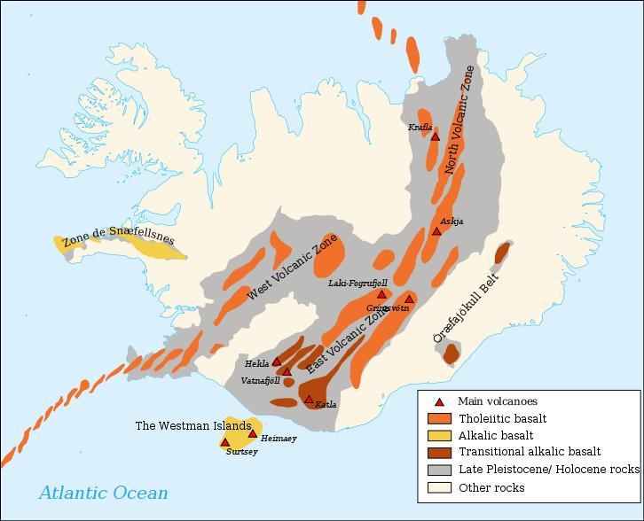
2 Iceland Svalbard Ellesmere and Baffin Islands Severny and Anzhu Islands Topics: Temperate vs non-temperate glaciers Tidewater glaciers Jökulhlaups Sandurs Surge behaviour


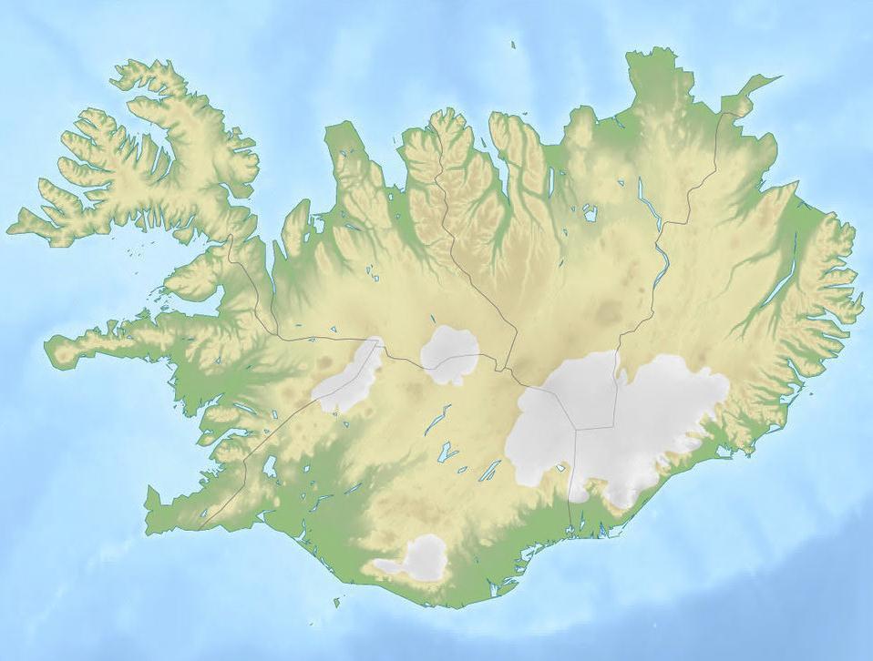
3 Ellesmere Anzhu Baffin Severny Svalbard Iceland
 This is not an ice-cap!")
4 Ice cap An ice cap is a relatively flat glacier (often occupying an upland area) that is less than 50,000 km 2 in area (<225 x 225 km) This is not an ice-cap! Many Arctic land masses north of 70 have ice caps Ice caps have outlet glaciers
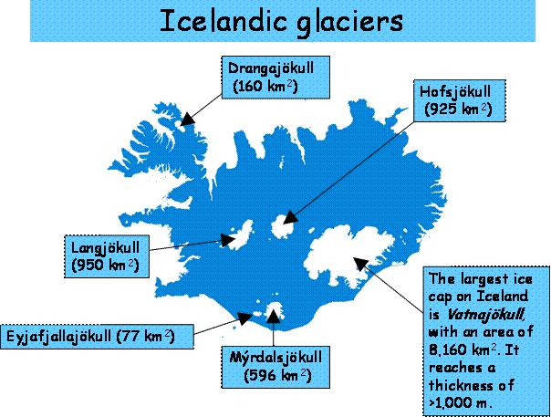
5 Temperate vs non-temperate glaciers A temperate glacier is at its melting point, throughout its thickness, for most of the year A polar glacier is below its freezing point, from surface to base, through most of the year A sub-polar or polythermal glacier is intermediate between these extremes, with both temperate and polar ice depending on the ice thickness and the elevation Temperate glaciers are common in areas where there is a lot of precipitation, so that while it might not be that cold, there is plenty of snow accumulation in winter Iceland and Svalbard have temperate glaciers, largely because of their proximity to the Gulf Stream
6 Tidewater glaciers A tidewater glacier reaches the ocean, and therefore exists in an area that either has a great deal of precipitation (as snow) or is very cold Iceland does not have tidewater glaciers, but the other Arctic ice-caps do
7 Jökulhlaup A jökulhlaup is a large outburst of water that was stored either beneath, on or in front of a glacier Iceland is famous for jökulhlaups, most of which are related to subglacial melting by volcanism, but any glacial outburst flood is a jökulhlaup
8 Sandur A glacial outwash plain composed of sand and gravel mostly as braided deposits Some sandurs are strongly affected by jökulhlaups
9 Surge glaciers Most glaciers move relatively steadily Some glaciers surge dramatically on time scales of months to years (with years to centuries of relative quiescence) Surging can be facilitated by changes in water flow (as we saw in Greenland), by temperature changes, or because of failure of the bed material Many of the Svalbard glaciers show surge behaviour
10
11
12
13

14 H. Björnsson, 2002, Global and Planetary Change, V. 35.

15 Two different types of sub-glacial lakes. The one on the left is relatively stable. The one on the right is unstable. H. Björnsson, 2002

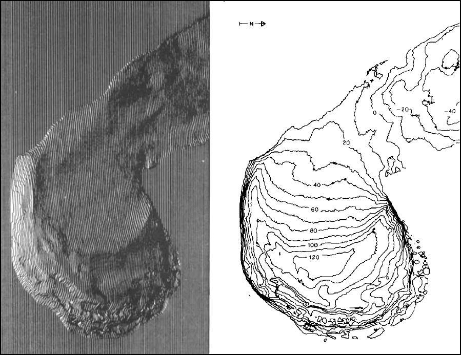
16 Ice-surface subsidence above subglacial lakes that have been drained by jökulhlaups H. Björnsson, 2002

17 The Skeidara sandur (outwash plain) from Vatnajokull to the coast. Dykes control the river on the left hand side. The bridge across the river is 900 m long. H. Björnsson, 2002
. Vatnajokull Russell, et al., 2006, Geomorphology 75, 33 64")
18 Major jökulhlaup outflows often produce largescale cross beds, either normal, or reverse like these (because of standing waves). Vatnajokull Russell, et al., 2006, Geomorphology 75, 33 64
19 The lake level of Grımsvötn The lake level ascends until a jökulhlaup takes place. In 1996 the lake rose to the level required for floating of the ice dam. The average interval is about 4 years, although many are around 6 years. H. Björnsson, 2002
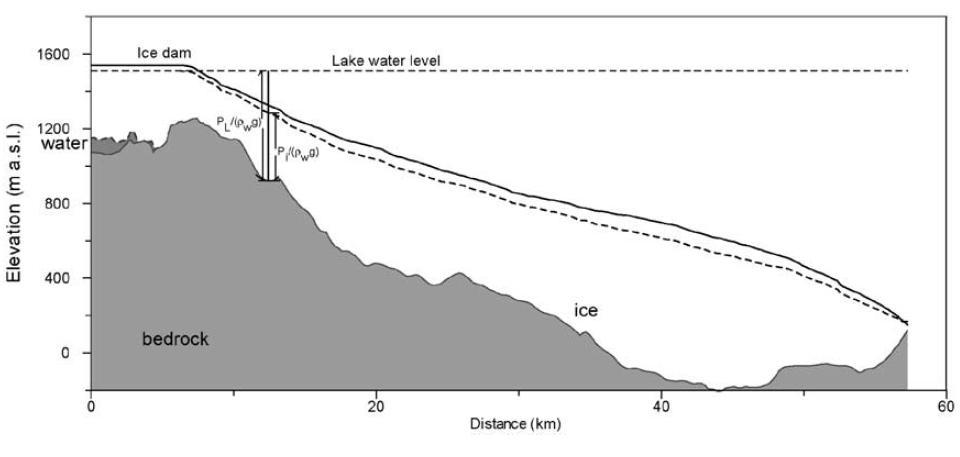
20 H. Björnsson, 2002
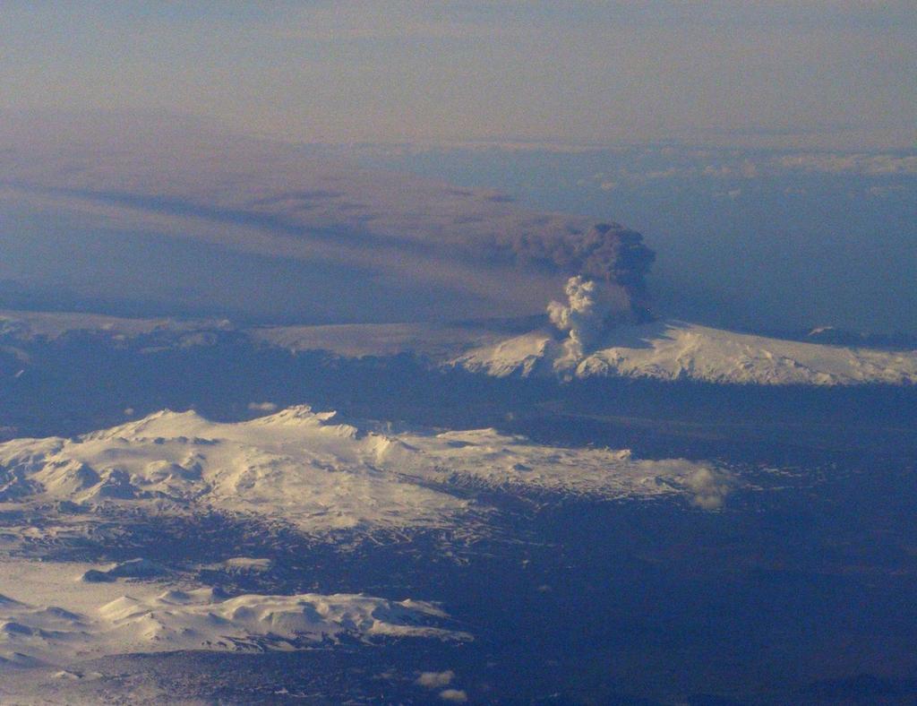

21 Jökulhlaup cascading off the margins of the Eyjafjallajokull volcano, Iceland, on 14th April 2010
22 Ice-cap and outlet glaciers on Svalbard
23 Ellesmere Anzhu Baffin Severny Svalbard Iceland
24
25 Surge Glaciers ~1% of glaciers on earth show surge behaviour (13 to 90% of Svalbard Glaciers) Glacier becomes decoupled from its base On Svalbard most surge glaciers are in areas where the bed is soft sedimentary rock (and therefore the till is soft and clay-rich) Base temperature also appears to be an important factor

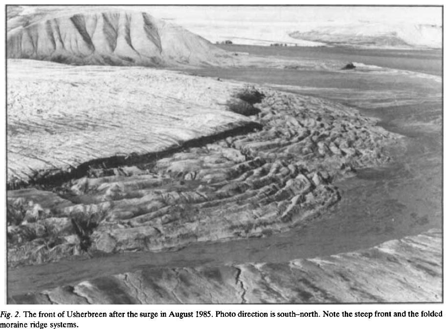
26 Hagen, J : Glacier surge at Usherbreen, Svalbard. Polar Research 5 p Usherbreen started to surge in 1978, and the front has advanced 1.5 km and covered an area of 4.5 km'. During the first two years the front advanced more than 1 m/d, and the front was still advancing m/d in 1985, seven years after the start. The mean gradient of the lower 7km decreased from 3.3 grad. to 1.8 grad. during the surge. The volume of ice transported down the glacier from higher to lower parts during the surge was 815 x 10hm3. which is almost 20% of the total glacier volume. Old ice-cored ridges in front of the glacier were reactivated, and the whole ridge system was pushed forward, in the summer of 1985 at a speed of about 0.05 m/d. Parts of the ridge system were moved 200 m during this surge. New ridges were developed on the flat sandur in front of the old ridge system. This demonstrates that the glacier advanced further than in any previous surge. Jon Oue Hagen. Norsk Polarinstitun. Oslo Lufthavn, Norway;

27 Hagen, J : Glacier surge at Usherbreen, Svalbard. Polar Research 5 p Usherbreen started to surge in 1978, and the front has advanced 1.5 km and covered an area of 4.5 km'. During the first two years the front advanced more than 1 m/d, and the front was still advancing m/d in 1985, seven years after the start. The mean gradient of the lower 7km decreased from 3.3 grad. to 1.8 grad. during the surge. The volume of ice transported down the glacier from higher to lower parts during the surge was 815 x 10hm3. which is almost 20% of the total glacier volume. Old ice-cored ridges in front of the glacier were reactivated, and the whole ridge system was pushed forward, in the summer of 1985 at a speed of about 0.05 m/d. Parts of the ridge system were moved 200 m during this surge. New ridges were developed on the flat sandur in front of the old ridge system. This demonstrates that the glacier advanced further than in any previous surge. Jon Oue Hagen. Norsk Polarinstitun. Oslo Lufthavn, Norway;
28
29

30 Bakaninbreen Murray et al, 1998, J. Glaciology, V. 44


31 Bakaninbreen (B) before (1970) the 1985 to 1990 surge Bakaninbreen after (1990) the 1985 to 1990 surge Murray et al, 1998, J. Glaciology, V. 44
32 In the surge area (upglacier from the surge front) the icesheet base is warm (at the freezing point). Downglacier from the surge front the basal ice is cold. Murray and Porter, 2001, Quat. International, V. 86
33 Mechanism The Bakaninbreen surge ( ) took place in an area with a warm base The front of the surge was at the warm-cold boundary, and that boundary moved ahead during the surge (because the melting front moved) Part of the movement in the warm-cold boundary was due to heat created by sliding Eventually the movement stopped because there wasn t enough heat to warm any more of the base Murray and Porter, 2001, Quat. International, V. 86
34 Surge-affected drainage from Skeiðarárjökull in 1991 In late March 1991, Skeiðarárjökull began to surge. The surge motion was not measured but deduced from the formation of abundant new crevasses, which was monitored from the air. Crevasses initially formed 10 km upglacier from the terminus and propagated up- and down-glacier. The area affected by increased sliding, producing crevasses, continued to expand up-glacier until the end of October. It ultimately extended some 45 km upwards from the front to within 5 km of the centre of the ice dam containing the Grımsvötn lake. Bjornsson, 1998, Nature, V. 395
35 Surge-affected drainage from Skeiðarárjökull in 1991 In early May, a 50-m-high surge front reached the eastern part of the terminus and, after having advanced 450 m, stopped in mid-july. In mid-september drainage began from Grımsvötn lake. The discharge of the lake water increased approximately exponentially and then fell rapidly; this may be explained as drainage through a single tunnel from the lake. The drainage, however, failed to develop into a normal outburst flood and terminated when less than a quarter of the lake volume had drained. In late September, the western half of the terminus started to advance, and moved forward about 1,000m before halting in early November. Bjornsson, 1998
36 Johnson et al., 2010, Geology, V. 38

37 (non-surge) (surge type) Johnson et al., 2010, Geology, V. 38
38 Johnson et al., 2010, Geology, V. 38

39 Johnson et al., 2010, Geology, V. 38
Assessment of possible jôkulhlaups from Lake Demmevatn in Norway
 The Eslrciui's of flu' Extremes: Eflraortlinarv Floods (Proceedings of ;i svinposinm held ill Reykjavik. Iceland. July 2000). IAliSPubl.no. 271. 2002. 31 Assessment of possible jôkulhlaups from Lake Demmevatn
Glaciers form wherever snow and ice can accumulate High latitudes High mountains at low latitudes Ice temperatures vary among glaciers Warm
 The Cryosphere Glaciers form wherever snow and ice can accumulate High latitudes High mountains at low latitudes Ice temperatures vary among glaciers Warm (temperate) glaciers: at pressure melting point,
Chapter 2. Wearing Down Landforms: Rivers and Ice. Physical Weathering
 Chapter 2 Wearing Down Landforms: Rivers and Ice Physical Weathering Weathering vs. Erosion Weathering is the breakdown of rock and minerals. Erosion is a two fold process that starts with 1) breakdown
The initiation of the 1996 jôkulhlaup from Lake Grimsvôtn, Vatnajôkull, Iceland
 Tilt: Extremes of the Extremes: Extraordinary Floods (Proceedings of a symposium held at Reykjavik. Iceland. July 2000). I AI IS Publ. no. 271. 2002. 57 The initiation of the 1996 jôkulhlaup from Lake
Glacial processes and landforms NGEA01, 2014
 Glacial processes and landforms NGEA01, 2014 Cecilia Akselsson Department of Physical Geography and Ecosystem Science Lund University Geomorphological processes and landforms all over the world Periglacial
Class Notes: Surface Processes
 Name: Date: Period: Surface Processes The Physical Setting: Earth Science Class Notes: Surface Processes I. Weathering and Soils Weathering -! Sediments -! Weathering occurs when rocks are exposed to:
Lecture 10 Glaciers and glaciation
 Lecture 10 Glaciers and glaciation Outline Importance of ice to people! Basics of glaciers formation, classification, mechanisms of movement Glacial landscapes erosion and deposition by glaciers and the
Glaciology (as opposed to Glacial Geology) Why important? What are glaciers? How do they work?
 Why important? What are glaciers? How do they work?") Glaciology (as opposed to Glacial Geology) Why important? What are glaciers? How do they work? Glaciers are important because of their role in creating glacial landscapes (erosional and depositional features).
Glaciology (as opposed to Glacial Geology) Why important? What are glaciers? How do they work? Glaciers are important because of their role in creating glacial landscapes (erosional and depositional features).
Prentice Hall EARTH SCIENCE
 Prentice Hall EARTH SCIENCE Tarbuck Lutgens Chapter 7 Glaciers, Desert, and Wind 7.1 Glaciers Types of Glaciers A glacier is a thick ice mass that forms above the snowline over hundreds or thousands of
Glacial Modification of Terrain
 Glacial Modification Part I Stupendous glaciers and crystal snowflakes -- every form of animate or inanimate existence leaves its impress upon the soul of man. 1 -Orison Swett Marden Glacial Modification
Changing Landscapes: Glaciated Landscapes. How do glaciers move?
 Changing Landscapes: Glaciated Landscapes How do glaciers move? What you need to know Differences between cold-and warm-based glaciers, their locations and rates of movement Glacier ice movement including
Amazing Ice: Glaciers and Ice Ages
 Amazing Ice: Glaciers and Ice Ages Updated by: Rick Oches, Professor of Geology & Environmental Sciences Bentley University Waltham, Massachusetts Based on slides prepared by: Ronald L. Parker, Senior
Grade 8 Science. Unit 1: Water Systems on Earth Chapter 1
 Grade 8 Science Unit 1: Water Systems on Earth Chapter 1 Effects of Water? Churchill River Large Ocean Wave How do you use water? House Hold Use Personal Use Recreational Activities Water Distribution
Physics of Glaciers: Glacier Hydraulics
 Introduction Theory Examples References Physics of Glaciers: Glacier Hydraulics Mauro A. Werder VAW / ETHZ 27.11.2017 Introduction Theory Examples References Problems Front matters Me: postdoc at VAW specialising
ICE DAM FLUCTUATIONS AT THE MARGINAL LAKE GRÆNALÓN (ICELAND) BEFORE AND DURING A GLOF
 BEFORE AND DURING A GLOF") ICE DAM FLUCTUATIONS AT THE MARGINAL LAKE GRÆNALÓN (ICELAND) BEFORE AND DURING A GLOF Kilian Scharrer 1, Ch. Mayer 2, S. Martinis 1, U. Münzer 1, Á. Gudmundsson 3 1 Ludwig-Maximilians-University, Department
ICE DAM FLUCTUATIONS AT THE MARGINAL LAKE GRÆNALÓN (ICELAND) BEFORE AND DURING A GLOF Kilian Scharrer 1, Ch. Mayer 2, S. Martinis 1, U. Münzer 1, Á. Gudmundsson 3 1 Ludwig-Maximilians-University, Department
3.13Glaciers past and present
 3.13Glaciers past and present We start with a headline from The Scotsman newspaper that rocked Britain s scientific establishment on the morning of 7 October 1840: 3 Discovery of the Former Existence of
Topic 6: Weathering, Erosion and Erosional-Deposition Systems (workbook p ) Workbook Chapter 4, 5 WEATHERING
 Workbook Chapter 4, 5 WEATHERING") Topic 6: Weathering, Erosion and Erosional-Deposition Systems (workbook p. 95-125) Workbook Chapter 4, 5 THE BIG PICTURE: Weathering, erosion and deposition are processes that cause changes to rock material
Topic 6: Weathering, Erosion and Erosional-Deposition Systems (workbook p. 95-125) Workbook Chapter 4, 5 THE BIG PICTURE: Weathering, erosion and deposition are processes that cause changes to rock material
1. Any process that causes rock to crack or break into pieces is called physical weathering. Initial product = final product
 Weathering 1. Any process that causes rock to crack or break into pieces is called physical weathering. Initial product = final product End Result of physical weathering is increased surface area. 2. Physical
Wednesday, November 15, 2017
 Wednesday, November 15, 2017 Northern Europe: Physical Geography Objective: Locate and describe the various traditional regions of Western Europe. Outline how the physical geography varies from region
Glacier Hydrology. Why should you care?
 Glacier Hydrology Why should you care? Climate Local Meteorology Surface Mass And Energy Exchange Net Mass Balance Dynamic Response Effect on Landscape Changes In Geometry Water Flow PRACTICAL MATTERS:
PHYSICAL GEOGRAPHY. By Brett Lucas
 PHYSICAL GEOGRAPHY By Brett Lucas GLACIAL PROCESSES Glacial Processes The Impact of Glaciers on the Landscape Glaciations Past and Present Types of Glaciers Glacier Formation and Movement The Effects of
CLIMATE READY BOSTON. Climate Projections Consensus ADAPTED FROM THE BOSTON RESEARCH ADVISORY GROUP REPORT MAY 2016
 CLIMATE READY BOSTON Sasaki Steering Committee Meeting, March 28 nd, 2016 Climate Projections Consensus ADAPTED FROM THE BOSTON RESEARCH ADVISORY GROUP REPORT MAY 2016 WHAT S IN STORE FOR BOSTON S CLIMATE?
CARD #1 The Shape of the Land: Effects of Crustal Tilting
 CARD #1 The Shape of the Land: Effects of Crustal Tilting When we look at a birds-eye view of the Great Lakes, it is easy to assume the lakes are all at a similar elevation, but viewed in this way, we
Glacial Geomorphology Lecture 1: Glaciers & Glacial Environments. GGY 166: Geomorphology of Southern Africa
 Glacial Geomorphology Lecture 1: Glaciers & Glacial Environments GGY 166: Geomorphology of Southern Africa Relevance in Southern African Context South African landscape has been influenced by glacial action
Chapter 2: Physical Geography
 Chapter 2: Physical Geography Pg. 39-68 Learning Goals for Chp2: q q q q q Explain how the Earth moves in space and why seasons change. Outline the factors that influence climate and recognize different
ESS 431 Principles of Glaciology ESS 505 The Cryosphere
 MID-TERM November 9, 2015 ESS 431 Principles of Glaciology ESS 505 The Cryosphere Instructions: Please answer the following 5 questions. [The actual 5 questions will be selected from these 12 questions
4. What type of glacier forms in a sloping valley between rock walls? a. firn glacier b. ice sheet c. cirque d. alpine glacier
 Multiple Choice Questions 1. The term means the loss of snow and ice by evaporation and melting. a. sublimation b. ablation c. erosion d. abrasion 2. What condition must be met for a glacier to begin flowing
Geography Advanced Subsidiary Paper 1
 Pearson Edexcel Level 3 GCE Geography Advanced Subsidiary Paper 1 Sample assessment material for first teaching September 2016 Resource Booklet Paper Reference 8GE0/01 Do not return this Resource Booklet
but 2012 was dry Most farmers pulled in a crop
 After a winter that wasn t, conditions late in the year pointed to a return to normal snow and cold conditions Most farmers pulled in a crop but 2012 was dry b y M i k e Wr o b l e w s k i, w e a t h e
SVALBARD. Environmental changes in Svalbard since the last glacial maximum THE ROLE OF PERMAFROST
 SVALBARD Environmental changes in Svalbard since the last glacial maximum THE ROLE OF PERMAFROST Bernd Etzelmüller, Oslo, Norway With contribution by Hanne H. Christiansen, UNIS, Svalbard Discussion points
Glaciers Earth 9th Edition Chapter 18 Glaciers: summary in haiku form Key Concepts Glaciers Glaciers Glaciers Glaciers
 1 2 3 4 5 6 7 8 9 10 11 12 13 14 Earth 9 th Edition Chapter 18 : summary in haiku form Ten thousand years thence big glaciers began to melt - called "global warming." Key Concepts and types of glaciers.
Social Studies. Chapter 2 Canada s Physical Landscape
 Social Studies Chapter 2 Canada s Physical Landscape Introduction Canada s geography its landforms and climate - has a great impact on Canadians sense of identity. Planet Earth The earth is divided into
Weathering, Erosion, Deposition
 Weathering, Erosion, Deposition The breakdown of rocks at or near the Earth s Surface. Physical Chemical - The breakdown of rock into smaller pieces without chemical change. - Dominant in moist /cold conditions
Waterways from glaciers to coastal waters in Iceland. Jórunn Harðardóttir, IMO Nordic WFD conference September 26, 2012
 Waterways from glaciers to coastal waters in Iceland Jórunn Harðardóttir, IMO Nordic WFD conference September 26, 2012 What to include and what not to include? Hydrology of Iceland Much on glaciers and
Weathering, Erosion and Deposition
 Weathering, Erosion and Deposition Shaping the Earth s Surface Weathering the process of breaking down rocks into smaller fragments Erosion the transport of rock fragments from one location to another
Chapter 6, Part Colonizers arriving in North America found extremely landscapes. It looked different to region showing great.
 Social Studies 9 Unit 1 Worksheet Chapter 6, Part 1. 1. Colonizers arriving in North America found extremely landscapes. It looked different to region showing great. 2. The Earth is years old and is composed
Glaciers. (Shaping Earth s Surface, Part 6) Science 330 Summer 2005
 Science 330 Summer 2005") Glaciers (Shaping Earth s Surface, Part 6) Science 330 Summer 2005 1 Glaciers Glaciers are parts of two basic cycles Hydrologic cycle Rock cycle Glacier a thick mass of ice that originates on land from
Glaciers (Shaping Earth s Surface, Part 6) Science 330 Summer 2005 1 Glaciers Glaciers are parts of two basic cycles Hydrologic cycle Rock cycle Glacier a thick mass of ice that originates on land from
2/23/2009. Visualizing Earth Science. Chapter Overview. Deserts and Drylands. Glaciers and Ice Sheets
 Visualizing Earth Science By Z. Merali and B. F. Skinner Chapter 6 Deserts, Glaciers and Ice Sheets Chapter Overview Deserts and Drylands Glaciers and Ice Sheets Deserts Geography Categorization of deserts
The Great Ice Ages. Copyright abcteach.com 2001 Graphics from Art Today
 The Great Ice Ages The Great Ice Ages occurred during the Pleistocene epoch. The word epoch means time period. This period began about 2.5 million years ago and ended roughly 10,000 years ago. During the
STREAM SYSTEMS and FLOODS
 STREAM SYSTEMS and FLOODS The Hydrologic Cycle Precipitation Evaporation Infiltration Runoff Transpiration Earth s Water and the Hydrologic Cycle The Hydrologic Cycle The Hydrologic Cycle Oceans not filling
Precipitation Evaporation Infiltration Earth s Water and the Hydrologic Cycle. Runoff Transpiration
 STREAM SYSTEMS and FLOODS The Hydrologic Cycle Precipitation Evaporation Infiltration Earth s Water and the Hydrologic Cycle Runoff Transpiration The Hydrologic Cycle The Hydrologic Cycle Oceans not filling
Landscape. Review Note Cards
 Landscape Review Note Cards Last Ice Age Pleistocene Epoch that occurred about 22,000 Years ago Glacier A large, long lasting mass of ice which forms on land and moves downhill because of gravity. Continental
BLAKENEY ESKER AND HOW IT FORMED. The Blakeney Esker is a ridge, around 3.5 km in length, which runs southeastwards
 BLAKENEY ESKER AND HOW IT FORMED Introduction The Blakeney Esker is a ridge, around 3.5 km in length, which runs southeastwards from west of Blakeney, to Wiveton Downs, north-west of Glandford, in north
Description DESCRIPTION
 DESCRIPTION The location of the Upper James Watershed is located in northeastern South Dakota as well as southeastern North Dakota. It includes the following counties located in North Dakota Barnes, Dickey,
1. Which type of climate has the greatest amount of rock weathering caused by frost action? A) a wet climate in which temperatures remain below
 a wet climate in which temperatures remain below") 1. Which type of climate has the greatest amount of rock weathering caused by frost action? A) a wet climate in which temperatures remain below freezing B) a wet climate in which temperatures alternate
1. Which type of climate has the greatest amount of rock weathering caused by frost action? A) a wet climate in which temperatures remain below freezing B) a wet climate in which temperatures alternate
Ice on Earth: An overview and examples on physical properties
 Ice on Earth: An overview and examples on physical properties - Ice on Earth during the Pleistocene - Present-day polar and temperate ice masses - Transformation of snow to ice - Mass balance, ice deformation,
6. What has been the most effective erosive agent in the climate system? a. Water b. Ice c. Wind
 Multiple Choice. 1. Heinrich Events a. Show increased abundance of warm-water species of planktic foraminifera b. Show greater intensity since the last deglaciation c. Show increased accumulation of ice-rafted
How do glaciers form?
 Glaciers What is a Glacier? A large mass of moving ice that exists year round is called a glacier. Glaciers are formed when snowfall exceeds snow melt year after year Snow and ice remain on the ground
Katla: Iceland s sleeping giant
 Katla: Iceland s sleeping giant (answers in red) Setting the scene The volcano Katla last erupted in 1918 and many people believe that its next eruption is overdue. Katla is one of a line of volcanoes
Glacial Erosion Polished on front side Glacial striations (scratches) on top
 on top") St Mary s Cemetery Glacial Erosion Polished on front side Glacial striations (scratches) on top Weathering Water channel in the rock mechanical weathering Some rocks eroding faster than others mechanical
St Mary s Cemetery Glacial Erosion Polished on front side Glacial striations (scratches) on top Weathering Water channel in the rock mechanical weathering Some rocks eroding faster than others mechanical
Name: Which rock layers appear to be most resistant to weathering? A) A, C, and E B) B and D
 A, C, and E B) B and D") Name: 1) The formation of soil is primarily the result of A) stream deposition and runoff B) precipitation and wind erosion C) stream erosion and mass movement D) weathering and biological activity 2)
Name: 1) The formation of soil is primarily the result of A) stream deposition and runoff B) precipitation and wind erosion C) stream erosion and mass movement D) weathering and biological activity 2)
Outline 24: The Holocene Record
 Outline 24: The Holocene Record Climate Change in the Late Cenozoic New York Harbor in an ice-free world (= Eocene sea level) Kenneth Miller, Rutgers University An Ice-Free World: eastern U.S. shoreline
Lowland Glaciation North Wales
 Lowland Glaciation North Wales Background Although there have been many glaciations and advances in ice, the most significant for this are was the Dimlington Stadial which was a period of glacial advance
THE EARTH S RELIEF SOCIAL SCIENCES 1º ESO
 THE EARTH S RELIEF SOCIAL SCIENCES 1º ESO 1. THE STRUCTURE OF THE EARTH The Earth is divided into layers: The crust is the surface layer. It is a thin, solid layer made of rock. The Earth s crust has a
4. The map below shows a meandering stream. Points A, B, C, and D represent locations along the stream bottom.
 1. Sediment is deposited as a river enters a lake because the A) velocity of the river decreases B) force of gravity decreases C) volume of water increases D) slope of the river increases 2. Which diagram
Lecture Outline Lecture Outline Monday April 9-16, 2018 Questions? Announcements:
 Lecture Outline Lecture Outline Monday April 9-16, 2018 Questions? Announcements: Geology 101 Night Video: The Day After Tomorrow Hollywood disaster movie about the onset of a glacial period When: Monday
Soils, Hydrogeology, and Aquifer Properties. Philip B. Bedient 2006 Rice University
 Soils, Hydrogeology, and Aquifer Properties Philip B. Bedient 2006 Rice University Charbeneau, 2000. Basin Hydrologic Cycle Global Water Supply Distribution 3% of earth s water is fresh - 97% oceans 1%
Science 8 - Water Systems Test - Chapters 1-2
 Science 8 - Water Systems Test - Chapters 1-2 Multiple Choice (30 marks) Identify the choice that best completes the statement or answers the question. 1. What percentage represents the amount of fresh
3 Erosion and Deposition by Ice
 CHAPTER 12 3 Erosion and Deposition by Ice SECTION Agents of Erosion and Deposition BEFORE YOU READ After you read this section, you should be able to answer these questions: What are glaciers? How do
Modelling of surface to basal hydrology across the Russell Glacier Catchment
 Modelling of surface to basal hydrology across the Russell Glacier Catchment Sam GAP Modelling Workshop, Toronto November 2010 Collaborators Alun Hubbard Centre for Glaciology Institute of Geography and
T. Perron Glaciers 1. Glaciers
 T. Perron 12.001 Glaciers 1 Glaciers I. Why study glaciers? [PPT: Perito Moreno glacier, Argentina] Role in freshwater budget o Fraction of earth s water that is fresh (non-saline): 3% o Fraction of earth
Page 1. Name:
 Name: 1) Which property would best distinguish sediment deposited by a river from sediment deposited by a glacier? thickness of sediment layers age of fossils found in the sediment mineral composition
The impact of climate change on glaciers and glacial runoff in the Nordic countries
 The impact of climate change on glaciers and glacial runoff in the Nordic countries Tómas Jóhannesson, Guðfinna Aðalgeirsdóttir, Andreas Ahlstrøm, Liss M. Andreassen, Stein Beldring, Helgi Björnsson, Philippe
Runoff and drainage pattern derived from digital elevation models, Finsterwalderbreen, Svalbard
 Annals of Glaciology 31 2000 # International Glaciological Society Runoff and drainage pattern derived from digital elevation models, Finsterwalderbreen, Svalbard Jon Ove Hagen, 1 Bernd Etzelmu«ller, 1
W he natural resources of Adams
 Above: Houghton Rock, Town of Adams. Following Page: "The Hole in the Rock" on Rattlesnake Mound--both remnants of rock formed by ancient seas hundreds of millions of year5 ago. (Courtesy, H.H. Bennett
SPQ Module 20 Ice Flows
 SPQ Module 20 Ice Flows When Ray, Richard & Kevin received their sleds in Southern Chili they opened them with excitement, and Kevin remarked they look like little canoes. It is perhaps appropriate that
Lecture Outlines PowerPoint. Chapter 6 Earth Science 11e Tarbuck/Lutgens
 Lecture Outlines PowerPoint Chapter 6 Earth Science 11e Tarbuck/Lutgens 2006 Pearson Prentice Hall This work is protected by United States copyright laws and is provided solely for the use of instructors
Lithosphere Features Of Glacial Erosion. Corrie;
 Corrie; Lithosphere Features Of Glacial Erosion These are bowl like hollows in the sides of mountains formed by glacial erosion A small hollow on the side of a mountain will start to fill with snow all
mountain rivers fixed channel boundaries (bedrock banks and bed) high transport capacity low storage input output
 high transport capacity low storage input output") mountain rivers fixed channel boundaries (bedrock banks and bed) high transport capacity low storage input output strong interaction between streams & hillslopes Sediment Budgets for Mountain Rivers Little
mountain rivers fixed channel boundaries (bedrock banks and bed) high transport capacity low storage input output strong interaction between streams & hillslopes Sediment Budgets for Mountain Rivers Little
GUIDED READING CHAPTER 1: THE LAY OF THE LAND (Page 1)
") CHAPTER 1: THE LAY OF THE LAND (Page 1) Section 1 The Tidewater Region Directions: Use the information from pages 6-11 to complete the following statements. 1. In the southern part of the coast, the Tidewater
CHAPTER 1: THE LAY OF THE LAND (Page 1) Section 1 The Tidewater Region Directions: Use the information from pages 6-11 to complete the following statements. 1. In the southern part of the coast, the Tidewater
Ice Sheets and Glaciers
 Ice Sheets and Glaciers Technical University of Denmark Kees van der Veen Department of Geography University of Kansas Why are glaciers and ice sheets important? Large volume of fresh water stored in ice
Mountain Rivers. Gutta cavat lapidem. (Dripping water hollows out a stone) -Ovid, Epistulae Ex Ponto, Book 3, no. 10, 1. 5
 -Ovid, Epistulae Ex Ponto, Book 3, no. 10, 1. 5") Mountain Rivers Gutta cavat lapidem (Dripping water hollows out a stone) -Ovid, Epistulae Ex Ponto, Book 3, no. 10, 1. 5 Mountain Rivers Fixed channel boundaries (bedrock banks and bed) High transport
Mountain Rivers Gutta cavat lapidem (Dripping water hollows out a stone) -Ovid, Epistulae Ex Ponto, Book 3, no. 10, 1. 5 Mountain Rivers Fixed channel boundaries (bedrock banks and bed) High transport
Depositional Environment
 Depositional Environment Sedimentary depositional environment describes the combination of physical, chemical and biological processes associated with the deposition of a particular type of sediment. Types
Waterbury Dam Disturbance Mike Fitzgerald Devin Rowland
 Waterbury Dam Disturbance Mike Fitzgerald Devin Rowland Abstract The Waterbury Dam was completed in October 1938 as a method of flood control in the Winooski Valley. The construction began in April1935
Analyzing our Topic IF SO, MAKE THE CHANGES AND BE READY TO REPORT OUT!
 Analyzing our Topic Look at the opening slide. Does anything there (words, pictures) make you want to change your thoughts from the smarties and chalk activities? IF SO, MAKE THE CHANGES AND BE READY TO
Unit 3 Review - Surface Processes
 Unit 3 Review - Surface Processes 1. Why is the surface of Mercury covered with meteor impact craters, while Earth s surface has relatively few craters? A) Mercury is larger than Earth, so it gets hit
Erosion and deposition in the proglacial zone: the 1996 jôkulhlaup on Skeiôarârsandur, southeast Iceland
 The Extremes ofthe Extremes: Eylraordinarv Floods (Proceedings of a symposium held al Reykjavik. Iceland. July 2000). IAHS Publ. no. 271. 2002. 217 Erosion and deposition in the proglacial zone: the 1996
The Dynamic Earth Section 3. Chapter 3 The Dynamic Earth Section 3: The Hydrosphere and Biosphere DAY 1
 Chapter 3 The Dynamic Earth Section 3: The Hydrosphere and Biosphere DAY 1 The Hydrosphere The hydrosphere includes all of the water on or near the Earth s surface. This includes water in the oceans, lakes,
Chapter 1 Section 2. Land, Water, and Climate
 Chapter 1 Section 2 Land, Water, and Climate Vocabulary 1. Landforms- natural features of the Earth s land surface 2. Elevation- height above sea level 3. Relief- changes in height 4. Core- most inner
Lecture 21: Glaciers and Paleoclimate Read: Chapter 15 Homework due Thursday Nov. 12. What we ll learn today:! Learning Objectives (LO)
") Learning Objectives (LO) Lecture 21: Glaciers and Paleoclimate Read: Chapter 15 Homework due Thursday Nov. 12 What we ll learn today:! 1. 1. Glaciers and where they occur! 2. 2. Compare depositional and
Learning Objectives (LO) Lecture 21: Glaciers and Paleoclimate Read: Chapter 15 Homework due Thursday Nov. 12 What we ll learn today:! 1. 1. Glaciers and where they occur! 2. 2. Compare depositional and
1. The map below shows a meandering river. A A' is the location of a cross section. The arrows show the direction of the river flow.
 1. The map below shows a meandering river. A A' is the location of a cross section. The arrows show the direction of the river flow. Which cross section best represents the shape of the river bottom at
Which map shows the stream drainage pattern that most likely formed on the surface of this volcano? A) B)
 B)") 1. When snow cover on the land melts, the water will most likely become surface runoff if the land surface is A) frozen B) porous C) grass covered D) unconsolidated gravel Base your answers to questions
1. When snow cover on the land melts, the water will most likely become surface runoff if the land surface is A) frozen B) porous C) grass covered D) unconsolidated gravel Base your answers to questions
Glacier surging. Susitna Glacier, Alaska (AusAn Post) Glacier surging McCarthy Summer School, 2016 Gwenn Flowers, Simon Fraser University
 Glacier surging McCarthy Summer School, 2016 Gwenn Flowers, Simon Fraser University") Glacier surging Susitna Glacier, Alaska (AusAn Post) Glacier surging: overview DefiniAons DistribuAon of surge- type glaciers ObservaAons QualitaAve characterisacs QuanAtaAve measurements Surge trigger(s)
Glacier surging Susitna Glacier, Alaska (AusAn Post) Glacier surging: overview DefiniAons DistribuAon of surge- type glaciers ObservaAons QualitaAve characterisacs QuanAtaAve measurements Surge trigger(s)
Chapter 9 Notes: Ice and Glaciers, Wind and Deserts
 Chapter 9 Notes: Ice and Glaciers, Wind and Deserts *Glaciers and Glacial Features glacier is a mass of ice that moves over land under its own weight through the action of gravity Glacier Formation must
netw rks Guided Reading Activity Essential Question: How does geography influence the way people live? Earth's Physical Geography
 Guided Reading Activity Lesson 1 Earth and the Sun Essential Question: How does geography influence the way people live? Looking at Earth Directions: What are the layers that make up Earth? Use your textbook
CLIMATE CHANGE IMPACTS ON ICE REGIME OF THE RIVERS IN MONGOLIA
 Ice in the Environment: Proceedings of the 16th IAHR International Symposium on Ice Dunedin, New Zealand, 2nd 6th December 2002 International Association of Hydraulic Engineering and Research CLIMATE CHANGE
Impacts of the April 2013 Mean trough over central North America
 Impacts of the April 2013 Mean trough over central North America By Richard H. Grumm National Weather Service State College, PA Abstract: The mean 500 hpa flow over North America featured a trough over
What landforms make up Australia?!
 What landforms make up Australia? The tectonic forces of folding, faulting and volcanic activity have created many of Australia's major landforms. Other forces that work on the surface of Australia, and
What is a Glacier? Types of Glaciers
 Alpine & Continental Glaciers Glacial Mass Balance Glacial Ice Formation Glacial Movement & Erosion Erosional and Depositional Landforms The Pleistocene Epoch Geomorphology of SW Manitoba Chapter 17 1
Brita Horlings
 Knut Christianson Brita Horlings brita2@uw.edu https://courses.washington.edu/ess431/ Natural Occurrences of Ice: Distribution and environmental factors of seasonal snow, sea ice, glaciers and permafrost
TAKE HOME EXAM 8R - Geology
 Name Period Date TAKE HOME EXAM 8R - Geology PART 1 - Multiple Choice 1. A volcanic cone made up of alternating layers of lava and rock particles is a cone. a. cinder b. lava c. shield d. composite 2.
27. Running Water I (p ; )
") 27. Running Water I (p. 424-436; 440-444) Hydrosphere How much of the Earth s surface is covered by water? Earth's water is collectively called the and is stored in a number of so-called as follows: 1.
27. Running Water I (p. 424-436; 440-444) Hydrosphere How much of the Earth s surface is covered by water? Earth's water is collectively called the and is stored in a number of so-called as follows: 1.
Site 4.7. Thornhill Drumlin Jane K. Hart
 Site 4.7. Thornhill Drumlin Jane K. Hart Introduction The drumlins in the West of Ireland represent some of the best exposured features in the whole of Britain and Ireland, and have been studied by numerous
TEMPORAL VARIABILITY OF ICE FLOW ON HOFSJÖKULL, ICELAND, OBSERVED BY ERS SAR INTERFEROMETRY
 TEMPORAL VARIABILITY OF ICE FLOW ON HOFSJÖKULL, ICELAND, OBSERVED BY ERS SAR INTERFEROMETRY Florian Müller (1), Helmut Rott (2) (1) ENVEO IT, Environmental Earth Observation GmbH, Technikerstrasse 21a,
Earth Science Chapter 6 Section 2 Review
 Name: Class: Date: Earth Science Chapter 6 Section Review Multiple Choice Identify the choice that best completes the statement or answers the question. 1. Most streams carry the largest part of their
Surface Water and Stream Development
 Surface Water and Stream Development Surface Water The moment a raindrop falls to earth it begins its return to the sea. Once water reaches Earth s surface it may evaporate back into the atmosphere, soak
Weathering, Erosion, Deposition, and Landscape Development
 Weathering, Erosion, Deposition, and Landscape Development I. Weathering - the breakdown of rocks into smaller particles, also called sediments, by natural processes. Weathering is further divided into
Streams. Water. Hydrologic Cycle. Geol 104: Streams
 Streams Why study streams? Running water is the most important geologic agent in erosion, transportation and deposition of sediments. Water The unique physical and chemical properties of water make it
Subglacial Control on Glacier Flow in Northern Greenland
 Subglacial Control on Glacier Flow in Northern Greenland Beáta Csathó (University at Buffalo, SUNY, Buffalo, NY), C.J. van der Veen (U. of Kansas, Lawrence, KS) Ralph van Frese and Tim Leftwich (The Ohio
Fig Major air masses of the world
 Fig. 9.3 Major air masses of the world CLASSIFICATION FOUR BASIC CATEGORIES OF AIR MASSES: POLAR - P ARCTIC - A TROPICAL - T EQUATORIAL - E TWO DESIGNATIONS OF SURFACE IN SOURCE REGION MARITIME - m. CONTINENTAL