Subglacial Control on Glacier Flow in Northern Greenland
|
|
|
- Eleanore Ramsey
- 5 years ago
- Views:
Transcription
 Ralph van Frese and Tim Leftwich (The Ohio State University, Columbus, OH), Janos Kiss (ELGI, Hungary), Hyung Rae Kim (NASA/GSFC, Greenbelt, MD) and Alex Braun (U.")
1 Subglacial Control on Glacier Flow in Northern Greenland Beáta Csathó (University at Buffalo, SUNY, Buffalo, NY), C.J. van der Veen (U. of Kansas, Lawrence, KS) Ralph van Frese and Tim Leftwich (The Ohio State University, Columbus, OH), Janos Kiss (ELGI, Hungary), Hyung Rae Kim (NASA/GSFC, Greenbelt, MD) and Alex Braun (U. of Calgary, Canada) IGS Meeting on Earth & Planetary Ice-Volcano Interactions Reykjavik, Iceland June 19-23,
2 Overview Objective: understanding the causes of unusual surface features and subglacial topography in NW Greenland. Methodology and results: (1) Mapping shape and distribution of ice sheet features, basal valleys and subglacial hills (2) Estimating crustal thickness from free-air gravity anomaly (3) Reviewing other clues of geothermal conditions and bedrock geology (3) Mapping bedrock lithology from gravity and magnetic field data Conclusions and future work Reykjavik, Iceland June 19-23,


 Reykjavik, Iceland")
3 Greenland Ice Sheet, NW Greenland Major outlet glaciers: Humboldt (33), Peterman (1), Ryder (2) Mass balance and glacial dynamics: The region is close to being in balance and have relatively small accumulation, BUT Very large subglacial melt is measured under the floating tongue of Peterman Glacier A mini-surge has been observed by InSAR over Ryder Glacier Ice piracy is suggested between Humboldt and Peterman Complex and active subglacial hydrologic system!! Ice velocities from RADARSAT-1 data, 2000 (Rignot and Kanagaratnam, 2006) Reykjavik, Iceland June 19-23,
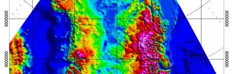
4 Surface Features in NW Greenland Shaded relief DEM from photoclinometry,, SAR and ICESat altimetry 250 km (1) Onset of Peterman Glacier (2) Sinuous surface depression and bedrock channel E of Peterman Glacier was interpreted as an interconnected system of subglacial lakes or water transportation (Ekholm( et al., 1998) (3) Surface features with oblique angles to current flow over Humboldt Glacier (4) Surface depressions over higher part of Humboldt and Peterman glaciers (5) Subglacial hills within (1) and (4) (Legarsky et al., 1998) Reykjavik, Iceland June 19-23,
5 Enlarged Features near the Onset of Peterman Glacier Onset Region 100 km Reykjavik, Iceland June 19-23,


")


 100")
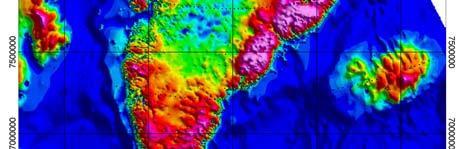
6 Discovery of Tunnel Valleys Bedrock DEM (color) and surface DEM (shading) (Bedrock DEM is From Bamber et al., 2001) 100 km Reykjavik, Iceland June 19-23,

 Interpolation created closed anomalies from")

7 Color-Coded Coded Bedrock Elevations over Shaded Relief Ice Surface DEM 50 km Radio echo sounding data from U. of Kansas (Gogineni et al.) Interpolation created closed anomalies from small, possibly connected depressions when distance between neighboring profiles is large!! Reykjavik, Iceland June 19-23,


8 Radio Echo Sounding Profile over Humboldt Drainage Basin 100 km V-shaped valleys, width: 3-4 km Reykjavik, Iceland June 19-23,


9 Radio Echo Sounding Profile over Peterman Drainage Basin Bedrock hills and U shaped valleys, width: 4-6 km Reykjavik, Iceland June 19-23,

10 Profiles over Bedrock Hills,, Peterman Drainage Basin B B A A B Reykjavik, Iceland June 19-23,
 Reykjavik, Iceland June 19-23, 2006 11")
11 Profile Across Peterman Glacier East West 1000 m 10 km 2.5 km 100 km (5:1) Reykjavik, Iceland June 19-23,


12 Along Peterman Glacier B B B B 50 km Reykjavik, Iceland June 19-23,

 some features might mark elongated ridges Reykjavik, Iceland June")
13 Distribution of Subglacial Hills 250 km North: features are aligned along western boundary of the Peterman onset region South: features are located in a region where ice flow direction might switch between Humboldt and Peterman Glaciers Note: (1) there could be unmapped features (2) some features might mark elongated ridges Reykjavik, Iceland June 19-23,

14 Subglacial Hills over the Onset Region of Peterman Glacier 100 km Reykjavik, Iceland June 19-23,
15 Bedrock Geology, Geothermal Subglacial geology: Conditions Lower Paleozoic Franklinian sedimentary basin in NW and NE Reworked Proteozoic crystalline rocks, outcroping in Victoria Fjord in the middle A large magmatic province, detected by aerogeophysical surveys in central and northern Greenland Subglacial volcanism: Glacial volcanic erratics,, NOT occuring in outcrops in N Greenland, has been described by Dawes et al., 2000 Geothermal heatflux: High and spatially variable geothermal flux is estimated at NGRIP (e.g. NGICP members, 2004) Lithospheric thinning and crustal thermal erosion might be related to the Icelandic hotspot track Reykjavik, Iceland June 19-23,

16 Reykjavik, Iceland June 19-23,

17 Reykjavik, Iceland June 19-23,

 Subglacial melt mapped from Internal layer thickness")
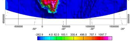
18 Comparison of Crustal Thickness and Indication of High Geothermal Heatflux NorthGRIP Crustal thickness Computed from Free-Air Gravity Anomalies (Braun et al., submitted) Subglacial melt mapped from Internal layer thickness (Fahnestock, personal com.) Reykjavik, Iceland June 19-23,
 250 km Data from")

19 Total Field Magnetic Map (nt( nt) 250 km Data from Verhoef et al., 1996 Reykjavik, Iceland June 19-23,
 250 km Data from J.")

20 Free-Air Gravity Anomaly Map (mgal) 250 km Data from J. Brozena and R. Forsberg Reykjavik, Iceland June 19-23,
21 Conclusions Glacial-geological conditions in NW Greenland are similar to those observed on WAIS, since NW Greenland is characterized by thin crust, a large sedimentary basement, high and spatially variable geothermal heat flux, large magnetic anomalies and a complex hydrological system. Bedrock geology controls the southern extent of Humboldt glacier and possibly the onset of streaming flow on Peterman Glacier Reykjavik, Iceland June 19-23,
22 Conclusions (cont) Bedrock hills are interpreted as volcanoes, possibly erupted subglacially Elongated subglacial depressions are interpreted as tunnel valleys created by sudden release of melt water, selective linear erosion (Humboldt) and active glacier erosion (curvilinear feature E of Peterman) Subglacial volcanic activity could contribute to important glacial dynamic processes, such as mini-surges of Ryder Glacier and observed high melt rate of the floating tongue of Peterman Glacier and therefore it has important implications for the mass balance and stability of the ice sheet Future work: a lot.. Reykjavik, Iceland June 19-23,
23 Acknowledgements Research was supported by NASA s s Polar Program We thank Bob Jacobel for valuable advices on the interpretation of ice penetrating radar data and Lindsay Shoenbohm for discussion on subglacial geomorphology. Reykjavik, Iceland June 19-23,
Geomorphologic Mapping by Airborne Laser Scanning in Southern Victoria Land
 Geomorphologic Mapping by Airborne Laser Scanning in Southern Victoria Land Bea Csatho, Terry Wilson, Tony Schenk, Garry McKenzie, Byrd Polar Research Center, The Ohio State University, Columbus, OH William
OZ SEEBASE TM. Datasets. Digital Elevation Model
 Digital Elevation Model 10 Digital Elevation Models (DEM s) often show the youngest structures, and any active geological structures. They are widely used for neotectonic analysis. The composition of eroding
Modeled and observed fast flow in the Greenland ice sheet
 Modeled and observed fast flow in the Greenland ice sheet Ed Bueler 1 Constantine Khroulev 1 Andy Aschwanden 2 Ian Joughin 3 1 Dept of Mathematics and Statistics, University of Alaska Fairbanks 2 Arctic
Glacial Modification of Terrain
 Glacial Modification Part I Stupendous glaciers and crystal snowflakes -- every form of animate or inanimate existence leaves its impress upon the soul of man. 1 -Orison Swett Marden Glacial Modification
Glacial processes and landforms NGEA01, 2014
 Glacial processes and landforms NGEA01, 2014 Cecilia Akselsson Department of Physical Geography and Ecosystem Science Lund University Geomorphological processes and landforms all over the world Periglacial
TEMPORAL VARIABILITY OF ICE FLOW ON HOFSJÖKULL, ICELAND, OBSERVED BY ERS SAR INTERFEROMETRY
 TEMPORAL VARIABILITY OF ICE FLOW ON HOFSJÖKULL, ICELAND, OBSERVED BY ERS SAR INTERFEROMETRY Florian Müller (1), Helmut Rott (2) (1) ENVEO IT, Environmental Earth Observation GmbH, Technikerstrasse 21a,
Ice Cap Glaciers in the Arctic Region. John Evans Glacier, Ellesmere Island (Robert Bingham, U. Aberdeen)
") Ice Cap Glaciers in the Arctic Region John Evans Glacier, Ellesmere Island (Robert Bingham, U. Aberdeen) Iceland Svalbard Ellesmere and Baffin Islands Severny and Anzhu Islands Topics: Temperate vs non-temperate
Ice Cap Glaciers in the Arctic Region John Evans Glacier, Ellesmere Island (Robert Bingham, U. Aberdeen) Iceland Svalbard Ellesmere and Baffin Islands Severny and Anzhu Islands Topics: Temperate vs non-temperate
Earthquakes. Earthquakes are caused by a sudden release of energy
 Earthquakes Earthquakes are caused by a sudden release of energy The amount of energy released determines the magnitude of the earthquake Seismic waves carry the energy away from its origin Fig. 18.1 Origin
A Living Planet. Chapter PHYSICAL GEOGRAPHY. What you will learn in this chapter. Summary of the chapter
 QUIT Main Ideas What you will learn in this chapter Summary Summary of the chapter Test your geographic knowledge by playing the. Main Ideas Section 1: The Earth Inside and Out The earth is the only habitable
Glaciers. (Shaping Earth s Surface, Part 6) Science 330 Summer 2005
 Science 330 Summer 2005") Glaciers (Shaping Earth s Surface, Part 6) Science 330 Summer 2005 1 Glaciers Glaciers are parts of two basic cycles Hydrologic cycle Rock cycle Glacier a thick mass of ice that originates on land from
Glaciers (Shaping Earth s Surface, Part 6) Science 330 Summer 2005 1 Glaciers Glaciers are parts of two basic cycles Hydrologic cycle Rock cycle Glacier a thick mass of ice that originates on land from
Landscape. Review Note Cards
 Landscape Review Note Cards Last Ice Age Pleistocene Epoch that occurred about 22,000 Years ago Glacier A large, long lasting mass of ice which forms on land and moves downhill because of gravity. Continental
Glacier Hydrology. Why should you care?
 Glacier Hydrology Why should you care? Climate Local Meteorology Surface Mass And Energy Exchange Net Mass Balance Dynamic Response Effect on Landscape Changes In Geometry Water Flow PRACTICAL MATTERS:
Basal topography and thinning rates of Petermann Gletscher, northern Greenland, measured by ground-based phase-sensitive radar
 Basal topography and thinning rates of Petermann Gletscher, northern Greenland, measured by ground-based phase-sensitive radar Craig Stewart British Antarctic Survey, Natural Environment Research Council,
Figure 1 The map shows the top view of a meandering stream as it enters a lake. At which points along the stream are erosion and deposition dominant?
 1. In which type of climate does chemical weathering usually occur most rapidly? 1. hot and dry 3. cold and dry 2. hot and wet 4. cold and wet 2. Figure 1 The map shows the top view of a meandering stream
GEOLOGY CURRICULUM. Unit 1: Introduction to Geology
 Chariho Regional School District - Science Curriculum September, 2016 GEOLOGY CURRICULUM Unit 1: Introduction to Geology OVERVIEW Summary In this unit students will be introduced to the field of geology.
Guided Notes Surface Processes. Erosion & Deposition By: Glaciers
 Guided Notes Surface Processes Erosion & Deposition By: Glaciers K. Coder 2015 26) How does moving ice erode and deposit sediments? Glaciers (Movement of Ice): a naturally formed mass of ice and snow that
Buoyant flexure and basal crevassing in dynamic mass loss at Helheim Glacier
 SUPPLEMENTARY INFORMATION DOI: 10.1038/NGEO2204 Buoyant flexure and basal crevassing in dynamic mass loss at Helheim Glacier Timothy D. James*, Tavi Murray, Nick Selmes, Kilian Scharrer and Martin O Leary
What is a Glacier? Types of Glaciers
 Alpine & Continental Glaciers Glacial Mass Balance Glacial Ice Formation Glacial Movement & Erosion Erosional and Depositional Landforms The Pleistocene Epoch Geomorphology of SW Manitoba Chapter 17 1
Marine Science and Oceanography
 Marine Science and Oceanography Marine geology- study of the ocean floor Physical oceanography- study of waves, currents, and tides Marine biology study of nature and distribution of marine organisms Chemical
Glaciers Earth 9th Edition Chapter 18 Glaciers: summary in haiku form Key Concepts Glaciers Glaciers Glaciers Glaciers
 1 2 3 4 5 6 7 8 9 10 11 12 13 14 Earth 9 th Edition Chapter 18 : summary in haiku form Ten thousand years thence big glaciers began to melt - called "global warming." Key Concepts and types of glaciers.
Ice flux divergence anomalies on 79north Glacier, Greenland
 GEOPHYSICAL RESEARCH LETTERS, VOL. 38,, doi:10.1029/2011gl047338, 2011 Ice flux divergence anomalies on 79north Glacier, Greenland H. Seroussi, 1,2 M. Morlighem, 1,2 E. Rignot, 1,3 E. Larour, 1 D. Aubry,
TAKE HOME EXAM 8R - Geology
 Name Period Date TAKE HOME EXAM 8R - Geology PART 1 - Multiple Choice 1. A volcanic cone made up of alternating layers of lava and rock particles is a cone. a. cinder b. lava c. shield d. composite 2.
Neogene Uplift of The Barents Sea
 Neogene Uplift of The Barents Sea W. Fjeldskaar A. Amantov Tectonor/UiS, Stavanger, Norway FORCE seminar April 4, 2013 The project (2010-2012) Funding companies Flat Objective The objective of the work
Down-stream process transition (f (q s ) = 1)
 = 1)") Down-stream process transition (f (q s ) = 1) Detachment Limited S d >> S t Transport Limited Channel Gradient (m/m) 10-1 Stochastic Variation { Detachment Limited Equilibrium Slope S d = k sd A -θ d S
Down-stream process transition (f (q s ) = 1) Detachment Limited S d >> S t Transport Limited Channel Gradient (m/m) 10-1 Stochastic Variation { Detachment Limited Equilibrium Slope S d = k sd A -θ d S
Answers: Internal Processes and Structures (Isostasy)
") Answers: Internal Processes and Structures (Isostasy) 1. Analyse the adjustment of the crust to changes in loads associated with volcanism, mountain building, erosion, and glaciation by using the concept
Answers: Internal Processes and Structures (Isostasy) 1. Analyse the adjustment of the crust to changes in loads associated with volcanism, mountain building, erosion, and glaciation by using the concept
GEOL.3250 Geology for Engineers Glacial Geology
 GEOL.3250 Geology for Engineers Glacial Geology NAME Part I: Continental Glaciation Continental glaciers are large ice sheets that cover substantial portions of the land area. In the region of accumulation
Determining the Direction of Ice Advance Forming the Roanoke Point Moraine From a Survey of Hartford Basin Erratics
 Determining the Direction of Ice Advance Forming the Roanoke Point Moraine From a Survey of Hartford Basin Erratics J Bret Bennington 1 and Tim Young 2 1 Department of Geology, 114 Hofstra University,
Chapter 2. The Planet Oceanus
 Chapter 2 The Planet Oceanus Composition of the Earth The Earth consists of a series of concentric layers or spheres which differ in chemistry and physical properties. There are two different ways to describe
Which landscape best represents the shape of the valleys occupied by glaciers? A) B) C) D)
 B) C) D)") 1. Glaciers often form parallel scratches and grooves in bedrock because glaciers A) deposit sediment in unsorted piles B) deposit rounded sand in V-shaped valleys C) continually melt and refreeze D) drag
1. Glaciers often form parallel scratches and grooves in bedrock because glaciers A) deposit sediment in unsorted piles B) deposit rounded sand in V-shaped valleys C) continually melt and refreeze D) drag
Radar Investigations of Ice Stream Margins: Data Report
 Radar Investigations of Ice Stream Margins: Data Report N. A. Nereson and C. F. Raymond Department of Earth and Space Sciences, Box 35131, University of Washington, Seattle, WA 98195-131 Contents 1 Introduction
Elevations are in meters above mean sea level. Scale 1:2000
 12.001 LAB 7: TOPOGRAPHIC MAPS Due: Monday, April 11 PART I: CONTOURING AND PROFILES (20 PTS) 1. Contour this area map using a 5 meter contour interval. Remember some fundamental rules of contour lines,
Ice Thickness and Subglacial Topography Studies by Ground Penetrating Radar during the XX Indian Antarctic Expedition
 Ice Thickness and Subglacial Topography Studies by Ground Penetrating Radar during the XX Indian Antarctic Expedition J.T. GERGAN and RENOJ J. THAYYEN Wadia Institute of Himalayan Geology, Dehradun, Uttaranchal
DETERMINATION OF ICE THICKNESS AND VOLUME OF HURD GLACIER, HURD PENINSULA, LIVINGSTONE ISLAND, ANTARCTICA
 Universidad de Granada MASTER S DEGREE IN GEOPHYSICS AND METEOROLOGY MASTER S THESIS DETERMINATION OF ICE THICKNESS AND VOLUME OF HURD GLACIER, HURD PENINSULA, LIVINGSTONE ISLAND, ANTARCTICA ÁNGEL RENTERO
GEOTHERMAL ENERGY POTENTIAL FOR LONGONOT PROSPECT, KENYA. By Mariita N. O. Kenya Electricity Generating Company
 GEOTHERMAL ENERGY POTENTIAL FOR LONGONOT PROSPECT, KENYA By Mariita N. O. Kenya Electricity Generating Company PRESENTATION OUTLINE INTRODUCTION REGIONAL SETTING GEOLOGY GEOTHERMAL MANIFESTATIONS HYDROGEOLOGY
Page 1. Name:
 Name: 1) Which property would best distinguish sediment deposited by a river from sediment deposited by a glacier? thickness of sediment layers age of fossils found in the sediment mineral composition
Subglacial topography inferred from ice surface terrain analysis reveals a large un-surveyed basin below sea level in East Antarctica
 GEOPHYSICAL RESEARCH LETTERS, VOL. 35, L16503, doi:10.1029/2008gl034728, 2008 Subglacial topography inferred from ice surface terrain analysis reveals a large un-surveyed basin below sea level in East
IEEE GEOSCIENCE AND REMOTE SENSING LETTERS, VOL. 2, NO. 4, OCTOBER
 IEEE GEOSCIENCE AND REMOTE SENSING LETTERS, VOL. 2, NO. 4, OCTOBER 2005 413 Digital Elevation Model of King Edward VII Peninsula, West Antarctica, From SAR Interferometry and ICESat Laser Altimetry Sangho
Antarctica & Greenland, Theory & Observations
 Ocean-Ice Interactions: Antarctica & Greenland, Theory & Observations Keck Institute for Space Studies September 9, 2013 David HOLLAND New York University + Abu Dhabi 0 Overview: Ocean-Ice Interface Delivery
PHYSICAL GEOGRAPHY. By Brett Lucas
 PHYSICAL GEOGRAPHY By Brett Lucas GLACIAL PROCESSES Glacial Processes The Impact of Glaciers on the Landscape Glaciations Past and Present Types of Glaciers Glacier Formation and Movement The Effects of
79 N Glacier. Sea ice. 20 km
 79 N Glacier Sea ice 20 km LandSat March 2014 Glaciers Kevin Mullins, Flagstaff Glaciers DefiniCon: a perennial body of ice that moves over land/water and forms from the accumulacon and compaccon of snow
Ice Sheets and Glaciers
 Ice Sheets and Glaciers Technical University of Denmark Kees van der Veen Department of Geography University of Kansas Why are glaciers and ice sheets important? Large volume of fresh water stored in ice
PART II. Physical Landscape Chapters 2 5
 PART II Physical Landscape Chapters 2 5 Prof. Anthony Grande 2016 Lecture design, content and presentation AFG 0616. Individual images and illustrations may be subject to prior copyright. R E M I N D E
GSA DATA REPOSITORY Sternai et al. 1. Algorithm Flow Chart
 GSA DATA REPOSITORY 2012311 Sternai et al. 1. Algorithm Flow Chart Figure DR1: Flow chart of the algorithm to further clarify the calculation scheme. 2. Reconstruction of the Pre-Glacial Alpine Topography
Highs and Lows Floods and Flows
 Highs and Lows Floods and Flows Planetary Mapping Facilitator Guide Becky Nelson Education Specialist The Lunar and Planetary Institute Highs and Lows, Floods and Flows Planetary Mapping Overview In this
3. GEOLOGY. 3.1 Introduction. 3.2 Results and Discussion Regional Geology Surficial Geology Mine Study Area
 3. GEOLOGY 3.1 Introduction This chapter discusses the baseline study of the geology and mineralization characteristics of the mine study area. The study consolidates existing geological data and exploration
Changing Landscapes: Glaciated Landscapes. How do glaciers move?
 Changing Landscapes: Glaciated Landscapes How do glaciers move? What you need to know Differences between cold-and warm-based glaciers, their locations and rates of movement Glacier ice movement including
Basin Analysis Applied to Modelling Buried Valleys in the Great Lakes Basin
 EARTH SCIENCES SECTOR GENERAL INFORMATION PRODUCT 35 Basin Analysis Applied to Modelling Buried Valleys in the Great Lakes Basin Sharpe, D R; Russell, H A J 2004 Originally released as: Basin Analysis
CARD #1 The Shape of the Land: Effects of Crustal Tilting
 CARD #1 The Shape of the Land: Effects of Crustal Tilting When we look at a birds-eye view of the Great Lakes, it is easy to assume the lakes are all at a similar elevation, but viewed in this way, we
Continental Landscapes
 Continental Landscapes Landscape influenced by tectonics, climate & differential weathering Most landforms developed within the last 2 million years System moves toward an equilibrium Continental Landscapes
Social Studies 9 UNIT 2 GEOGRAPHIC INFLUENCES ON IDENTITY: PLACE AND PEOPLE
 Social Studies 9 UNIT 2 GEOGRAPHIC INFLUENCES ON IDENTITY: PLACE AND PEOPLE The Structure of the Earth To understand the forces that create Canada's physical landscape we must understand the structure
Lecture Outlines PowerPoint. Chapter 6 Earth Science 11e Tarbuck/Lutgens
 Lecture Outlines PowerPoint Chapter 6 Earth Science 11e Tarbuck/Lutgens 2006 Pearson Prentice Hall This work is protected by United States copyright laws and is provided solely for the use of instructors
Grade 8 Science. Unit 1: Water Systems on Earth Chapter 1
 Grade 8 Science Unit 1: Water Systems on Earth Chapter 1 Effects of Water? Churchill River Large Ocean Wave How do you use water? House Hold Use Personal Use Recreational Activities Water Distribution
Chapter 5: Glaciers and Deserts
 I. Glaciers and Glaciation Chapter 5: Glaciers and Deserts A. A thick mass of ice that forms over land from the compaction and recrystallization of snow and shows evidence of past or present flow B. Types
Erosional Features. What processes shaped this landscape?
 Have you ever looked at the land around you and wondered what processes shaped what you see? Perhaps you see mountains, valleys, rivers, or canyons. Do you know how long these geologic features have been
UNIT 3 GEOLOGY VOCABULARY FLASHCARDS THESE KEY VOCABULARY WORDS AND PHRASES APPEAR ON THE UNIT 3 CBA
 UNIT 3 GEOLOGY VOCABULARY FLASHCARDS THESE KEY VOCABULARY WORDS AND PHRASES APPEAR ON THE UNIT 3 CBA A map that shows Earth s Topographic Map surface topography, which is Earth s shape and features Contour
Lecture 10 Glaciers and glaciation
 Lecture 10 Glaciers and glaciation Outline Importance of ice to people! Basics of glaciers formation, classification, mechanisms of movement Glacial landscapes erosion and deposition by glaciers and the
Swath Mode Altimetry. Noel Gourmelen
 Swath Mode Altimetry Noel Gourmelen 1 Outline Background Impact case studies: Topography Rates of surface elevation change 2 Products and applications of radar altimetry over Ice Sheet, Ice Caps, Glaciers:
4. What type of glacier forms in a sloping valley between rock walls? a. firn glacier b. ice sheet c. cirque d. alpine glacier
 Multiple Choice Questions 1. The term means the loss of snow and ice by evaporation and melting. a. sublimation b. ablation c. erosion d. abrasion 2. What condition must be met for a glacier to begin flowing
High-resolution ice-thickness mapping in South Greenland
 64 Annals of Glaciology 55(67) 2014 doi: 10.3189/2014AoG67A088 High-resolution ice-thickness mapping in South Greenland M. MORLIGHEM, 1 E. RIGNOT, 1;2 J. MOUGINOT, 1 H. SEROUSSI, 2 E. LAROUR 2 1 Department
Parts of the Sevier/ Laramide Orogeny
 Parts of the Sevier/ Laramide Orogeny AA. Accretionary Prism BB. Forearc Basin Sediment scraped off of subducting plate Sediment derived from the volcanic arc CC. Volcanic Arc Magmatic intrusion into the
Airborne gravity gradiometer surveying of petroleum systems under Lake Tanganyika, Tanzania
 Airborne gravity gradiometer surveying of petroleum systems under Lake Tanganyika, Tanzania D. Roberts Beach Energy P. Roy Chowdhury CGG S. J. Lowe CGG A. N. Christensen CGG Outline Introduction Geology
Why is Sebago Lake so deep?
 Maine Geologic Facts and Localities February, 1999 Why is Sebago Lake so deep? 43 51 13.36 N, 70 33 43.98 W Text by Robert A. Johnston, Department of Agriculture, Conservation & Forestry 1 Introduction
SPQ Module 20 Ice Flows
 SPQ Module 20 Ice Flows When Ray, Richard & Kevin received their sleds in Southern Chili they opened them with excitement, and Kevin remarked they look like little canoes. It is perhaps appropriate that
Earth s Continents and Seafloors. GEOL100 Physical Geology Ray Rector - Instructor
 Earth s Continents and Seafloors GEOL100 Physical Geology Ray Rector - Instructor OCEAN BASINS and CONTINENTAL PLATFORMS Key Concepts I. Earth s rocky surface covered by of two types of crust Dense, thin,
RAYMOND SIEVER Harvard University
 E A R T H FOURTH EDITION FRANK PRESS National Academy of Sciences RAYMOND SIEVER Harvard University W. H. Freeman and Company New York Preface xiii Acknowledgments xviii PART I PROLOGUE CHAPTER 1 HISTORY
How do glaciers form?
 Glaciers What is a Glacier? A large mass of moving ice that exists year round is called a glacier. Glaciers are formed when snowfall exceeds snow melt year after year Snow and ice remain on the ground
2. What type of rocks would you expect in this area, based on the topography? What is your reasoning?
 Geology 101 Bonus Lab Name Topographic maps are useful in helping us interpret the history of the landscape of an area. The questions below are designed to help you learn to interpret topographic maps.
Exploring Geography. Chapter 1
 Exploring Geography Chapter 1 The Study of Geography Geography is the study of where people, places, and things are located and how they relate to each other. Greek meaning writing about or describing
The Geology of Sebago Lake State Park
 Maine Geologic Facts and Localities September, 2002 43 55 17.46 N, 70 34 13.07 W Text by Robert Johnston, Department of Agriculture, Conservation & Forestry 1 Map by Robert Johnston Introduction Sebago
 Page 1 of 9 Name: Base your answer to the question on the diagram below. The arrows show the direction in which sediment is being transported along the shoreline. A barrier beach has formed, creating a
Kinematic Positioning with DGPS: Expanding Frontiers in Aerogeophysics
 http://www.nap.edu/openbookini000401/html/165.html. copyright 1997, 2000 The National Academy of Sciences, all rights reserved Kinematic Positioning with DGPS: Expanding Frontiers in Aerogeophysics Robin
Glacial Erosion Polished on front side Glacial striations (scratches) on top
 on top") St Mary s Cemetery Glacial Erosion Polished on front side Glacial striations (scratches) on top Weathering Water channel in the rock mechanical weathering Some rocks eroding faster than others mechanical
St Mary s Cemetery Glacial Erosion Polished on front side Glacial striations (scratches) on top Weathering Water channel in the rock mechanical weathering Some rocks eroding faster than others mechanical
Modeling Antarctic subglacial lake filling and drainage cycles
 The Cryosphere,, 38 393, 6 www.the-cryosphere.net//38/6/ doi:.594/tc--38-6 Author(s) 6. CC Attribution 3. License. Modeling Antarctic subglacial lake filling and drainage cycles Christine F. Dow,a, Mauro
Increased flow speed on a large East Antarctic outlet glacier due to subglacial floods
 Increased flow speed on a large East Antarctic outlet glacier due to subglacial floods LETTERS LEIGH A. STEARNS *, BENJAMIN E. SMITH AND GORDON S. HAMILTON Climate Change Institute, University of Maine,
UNSTOPPABLE COLLAPSE OF THE WEST ANTARCTIC ICE SHEET IS NOT HAPPENING
 UNSTOPPABLE COLLAPSE OF THE WEST ANTARCTIC ICE SHEET IS NOT HAPPENING Dr. Don J. Easterbrook, Western Washington University, Bellingham, WA May 19, 2014 A New York Times headline reads Scientists Warn
THE EARTH S RELIEF SOCIAL SCIENCES 1º ESO
 THE EARTH S RELIEF SOCIAL SCIENCES 1º ESO 1. THE STRUCTURE OF THE EARTH The Earth is divided into layers: The crust is the surface layer. It is a thin, solid layer made of rock. The Earth s crust has a
Page 1. Name:
 Name: Questions 1 through 3 refer to the following: The diagrams below represent two rock outcrops found several miles apart in New York State. Individual rock layers are lettered, and fossils and rock
EROSIONAL FEATURES. reflect
 reflect Have you ever looked at the land around you and wondered what processes shaped what you see? Perhaps you see mountains, valleys, rivers, or canyons. Do you know how long these geologic features
Science Olympiad Dynamic Earth: Glaciers
 Science Olympiad Dynamic Earth: Glaciers Write the appropriate response next to the corresponding number on the answer sheet. 1. Name 2 aspects of a glacier that define it as such (questions #1-2, 1 point
Name: Mid-Year Review #2 SAR
 Name: Mid-Year Review #2 SAR Base your answers to questions 1 through 3 on on the diagram below, which shows laboratory materials used for an investigation of the effects of sediment size on permeability,
25. SURVEY AT SITE 337, NEAR THE EXTINCT AXIS IN THE NORWAY BASIN
 25. SURVEY AT SITE 337, NEAR THE EXTINCT AXIS IN THE NORWAY BASIN M. Talwani and S. Sandal, Lamont-Doherty Geological Observatory of Columbia University, Palisades, New York In order to explain the asymmetric
Before Plate Tectonics: Theory of Continental Drift
 Before Plate Tectonics: Theory of Continental Drift Predecessor to modern plate tectonics Shape and fit of the continents was the initial evidence Snider-Pelligrini (1858) Taylor (1908) Wegner (1915) Fig.
Figure 3.1: Illustration showing the bathymetry s role for the tsunami propagation following the earth quake 26 December 2004 outside of Sumatra.
 Figure 3.1: Illustration showing the bathymetry s role for the tsunami propagation following the earth quake 26 December 2004 outside of Sumatra. The left globe shows the seafloor bathymetry as portrayed
topography half is commonly represented in maps, and how it interacts with
 Topography T. Perron 12.001 We ll spend a large fraction of the second half of the course discussing Earth s surface. Today we ll do two things: First, we ll discuss the ways topography is commonly represented
Plate Tectonics Lab II: Background Information
 Plate Tectonics Lab II: Background Information This lab is based on a UW ESS101 Lab. Note: Hand in only the Answer Sheet at the back of this guide to your Instructor Introduction One of the more fundamental
DRAFT. LINEAMENT GROUP 17c MAP DATA. A17c.1. Notch in DEM is less sharply expressed in the field. Tvu. Qg Tvu 4. Tfv. Qg Tfv. Tvu. Tfv.
 69 695 69 695 5 Notch in EM is less sharply expressed in the field 7c 69 A 7b 695 5 Tem v 5 Tvu Ti 7b Tvu v 5 A 7c Tem Tem Tvu TrPavs Qhg Tem 88 See Figure A7c. 88 v Tem Tvu 5 Jqd 8 TrPavs N Tvu Tvu km
Glacial Geomorphology Lecture 1: Glaciers & Glacial Environments. GGY 166: Geomorphology of Southern Africa
 Glacial Geomorphology Lecture 1: Glaciers & Glacial Environments GGY 166: Geomorphology of Southern Africa Relevance in Southern African Context South African landscape has been influenced by glacial action
Terrain Units PALEOGEOGRAPHY: LANDFORM CREATION. Present Geology of NYS. Detailed Geologic Map of NYS
 NYS TOPOGRAPHY Why so? PALEOGEOGRAPHY: LANDFORM CREATION Prof. Anthony Grande AFG 014 Present Geology of NYS Detailed Geologic Map of NYS Generalized Geology Detailed Geology Hot links to the fold out
Surface Processes Focus on Mass Wasting (Chapter 10)
") Surface Processes Focus on Mass Wasting (Chapter 10) 1. What is the distinction between weathering, mass wasting, and erosion? 2. What is the controlling force in mass wasting? What force provides resistance?
Surface Processes Focus on Mass Wasting (Chapter 10) 1. What is the distinction between weathering, mass wasting, and erosion? 2. What is the controlling force in mass wasting? What force provides resistance?
Outline 9: Origin of the Earth: solids, liquids, and gases. The Early Archean Earth
 Outline 9: Origin of the Earth: solids, liquids, and gases The Early Archean Earth Origin of Earth s Matter The earth is made of recycled elements formed in stars that existed prior to our Sun. Supernova
A) B) C) D) 4. Which diagram below best represents the pattern of magnetic orientation in the seafloor on the west (left) side of the ocean ridge?
 B) C) D) 4. Which diagram below best represents the pattern of magnetic orientation in the seafloor on the west (left) side of the ocean ridge?") 1. Crustal formation, which may cause the widening of an ocean, is most likely occurring at the boundary between the A) African Plate and the Eurasian Plate B) Pacific Plate and the Philippine Plate C)
1. Crustal formation, which may cause the widening of an ocean, is most likely occurring at the boundary between the A) African Plate and the Eurasian Plate B) Pacific Plate and the Philippine Plate C)
Chapter 7 Plate Tectonics. Plate tectonics accounts for important features of Earth s surface and major geologic events.
 Chapter 7 Plate Tectonics Plate tectonics accounts for important features of Earth s surface and major geologic events. 7-2 Alfred Wegener s Hypothesis of Continental Drift (1915) ONE single landmass
Outline 9: Origin of the Earth: solids, liquids, and gases
 Outline 9: Origin of the Earth: solids, liquids, and gases The Early Archean Earth Origin of Earth s Matter The earth is made of recycled elements formed in stars that existed prior to our Sun. Supernova
Prentice Hall EARTH SCIENCE
 Prentice Hall EARTH SCIENCE Tarbuck Lutgens Chapter 7 Glaciers, Desert, and Wind 7.1 Glaciers Types of Glaciers A glacier is a thick ice mass that forms above the snowline over hundreds or thousands of
Copyright McGraw-Hill Education. All rights reserved. No reproduction or distribution without the prior written consent of McGraw-Hill Education
 Copyright McGraw-Hill Education. All rights reserved. No reproduction or distribution without the prior written consent of McGraw-Hill Education Tibetan Plateau and Himalaya -southern Asia 11.00.a VE 10X
C) use of nuclear power D) number of volcanic eruptions
 use of nuclear power D) number of volcanic eruptions") 3121-1 - Page 1 Name: 1) The graph below shows the change in carbon dioxide concentration in parts per million (ppm) in Earth's atmosphere from 1960 to 1990. The most likely cause of the overall change
3121-1 - Page 1 Name: 1) The graph below shows the change in carbon dioxide concentration in parts per million (ppm) in Earth's atmosphere from 1960 to 1990. The most likely cause of the overall change
The elevations on the interior plateau generally vary between 300 and 650 meters with
 11 2. HYDROLOGICAL SETTING 2.1 Physical Features and Relief Labrador is bounded in the east by the Labrador Sea (Atlantic Ocean), in the west by the watershed divide, and in the south, for the most part,
SAMPLE PAGE. pulses. The Ice Age By: Sue Peterson
 Page 61 Objective sight words (pulses, intermittent, isotopes, chronicle, methane, tectonic plates, volcanism, configurations, land-locked, erratic); concepts (geological evidence and specific terminology
East Penn School District Curriculum and Instruction
 East Penn School District Curriculum and Instruction Curriculum for: Geology of National Parks Course(s): Geology of the National Parks Grades: 10-12 Department: Science Length of Period (average minutes):
Introduction to Landform Study Chapter 13
 Introduction to Landform Study Chapter 13 Geomorphology The study of the characteristics, origin, and development of landforms 58 million square miles of land 7 continents Wide latitudinal range and environmental