PART II. Physical Landscape Chapters 2 5
|
|
|
- Sharlene Chase
- 5 years ago
- Views:
Transcription
1 PART II Physical Landscape Chapters 2 5 Prof. Anthony Grande 2016 Lecture design, content and presentation AFG Individual images and illustrations may be subject to prior copyright. R E M I N D E R Two required essays are due by Nov. 14, (A third may be used for extra credit in place of a Think Geographically essay.) ESSAY TOPICS (choose any two): Contributions of a noted geographer, earth scientist or explorer (chapter 1) Relationship of climate change to a listed current event topic (ch. 2) Discuss a natural process that is deemed a natural hazard (ch. 3) Extra Credit: Think Geographically Essays from any five of the textbook s 12 chapters. Last day to submit is Dec 12 but it is best to do them as you finish reading a chapter. Any essay may be submitted before the deadline. Don t wait for the night before to write them!! PART II: People and their Physical Environment Geologic Influences I. Introduction to the Physical Environment II. Earth-Sun Relationship III. Earth Systems A. The Hydrosphere: Oceans B. The Atmosphere: Weather and Climate C. The Lithosphere: Geologic Influences IV. Earth Habitat A. Biosphere B. Natural Controls and Cycles C. Human Impact D. Natural Hazards 3 Geologic environment influences people living on the surface of the earth. The pattern of human activity is related to what is on and below the surface. Factors include: surface rock slope soil fertility water supply mineral resources geologic processes 4 Definitions GEOLOGY: scientific study of the earth: origin, structure and processes. GEOMORPHOLOGY: study of landforms: origin, characteristics, processes, evolution TOPOGRAPHY: study of surface features All used by geographers to evaluate location. GEOLOGIC CYCLE There are 3 parts to the geologic cycle: 1. Continental Drift: Plate Tectonic Theory 2. Rock Cycle: Creation of earth materials 3. Building and Gradational Processes: Creation and shaping of surface landform features 5 6 1


 in response to convective")


 Divergent or")
.")
.")
.")
2 Continental Drift Convection (heat cells) within the earth s interior. The crust of the earth shifts position in response to forces within its interior. The theory explaining it is called Plate Tectonics. Plate Tectonics Theory says that the continents and ocean floor are on lithospheric plates that float on the upper mantle. They collide and scrape against each other as they slowly shift position (drift) in response to convective forces within the earth. Plate Tectonics 7 8 Plate Boundaries OCEAN BASIN TOPOGRAPHY The ocean floor is not flat! The movements associated with plate tectonics have created an ocean floor with a great variety of features. Three types of boundary zones: a) Divergent or Spreading: new crust is formed from molten material (ridges formed). b) Convergent or Subduction: old crust is drawn back into the interior to be melted (trenches formed). c) Transform or horizontal sliding: plates rub against each other (fault lines with earthquakes) Atlantic and Indian Ocean Basin Topography Pacific and Arctic Ocean Basin Topography Spreading zones, deep sea trenches and sea mounts dominate the floor of the Pacific. ARCTIC OCEAN INDIAN OCEAN The Mid-Atlantic Ridge is the world s longest mountain chain

; sunlight penetrates to it \"Continental\" islands rise from the shelf (mountain tops). Examples: Long Island, Bahamas, British Isles It is the site of the fishing banks.")
 13 14 OCEAN BASIN TOPOGRAPHY Ocean Floor or Abyssal Plain. About 12,000-18,000 ft below the surface. It is very cold and very dark. Sunlight does not penetrate to these depths.")

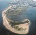
3 Generalized Ocean Basin Topography Ocean basin: deeply depressed area of the Earth s crust located between the continents that is filled with salt water. Coastal zone: area inland from the shore that has ocean-related features. Mean sea level: the height of the oceans calculated by averaging all high and low tides. Copy in Handouts section of course home page. OCEAN BASIN TOPOGRAPHY Continental Shelf is the underwater extension of the continent that flooded when sea level rose. It is fairly shallow (0-600 ft. deep); sunlight penetrates to it "Continental" islands rise from the shelf (mountain tops). Examples: Long Island, Bahamas, British Isles It is the site of the fishing banks. It is the site of off shore mineral deposits. Continental Slope is the edge of the continent that steeply descends to the ocean floor (c ,000 ft deep) OCEAN BASIN TOPOGRAPHY Ocean Floor or Abyssal Plain. About 12,000-18,000 ft below the surface. It is very cold and very dark. Sunlight does not penetrate to these depths. Few fish and bottom dwelling creatures live here, except near the thermal vents. It has the potential as a supplier of minerals. "Pelagic" islands, seamounts and ridges rise from the floor. Ex.: Hawaii, Iceland, Mid-Atlantic Ridge. OCEAN BASIN TOPOGRAPHY Trenches, deeps, troughs. These are the deepest points on the ocean floor extending below 18,000 ft. Here the crust is dragged back into the interior of the planet and is remelted. Mariana Trench, contains the deepest point on Earth: the bottom of the Challenger Deep is 36,070 ft (6.8 mi) below mean sea level Marianna Trench Geologic Hot Spots Hot spot: Zone of weakness in the earth s crust (ocean and continental) that allow molten material to breach the crust away from plate boundaries. Volcano Chains often trail away from midocean hotspots, with the oldest volcanoes, long extinct, now lying far away from the hotspot. These hotspot tracks are aligned along the direction of motion of the overlying plate. The Hawaiian Island Chain is an example of this. Challenger Deep -36,070 ft National Geographic
 are created and how they are interrelated to surface landforms and the internal processes of the")


4 Ancient Hawaiian islands extend to Alaska. Hot Spot under Hawaii ROCK CYCLE The ROCK CYCLE illustrates how earth materials (major rock types) are created and how they are interrelated to surface landforms and the internal processes of the earth ROCK CYCLE There are 3 major categories of rock: sedimentary igneous metamorphic Sedimentary Rocks Formed by the compaction and cementation of rock fragments by a process called lithification. They make up 75% of the earth s surface. Igneous Rocks Formed from the cooling of molten (liquid) rock. The molten rock is a soup of minerals. The rate of cooling determines the crystallization of minerals and their appearance. ROCK CYCLE Metamorphic Rocks Created as great heat and pressure is applied to existing rocks (sedimentary, igneous and other metamorphic rocks). They are baked. This changes their physical composition and creates a new material Forces Creating and Shaping Surface Landforms There are two opposing forces always at work: ENDOGENIC: tectonic or building forces EXOGENIC: gradational or reducing forces They are part of dynamic earth, including the rock cycle, and interact with both atmospheric and hydrologic processes. These forces are usually present together. Cannot have just one process working although one may be dominant. Forces Creating and Shaping Surface Landforms TECTONIC or building forces are: a) FOLDING: compression, bending breaking b) FAULTING: movement, tension, breaking c) VOLCANISM: melting, movement of molten material, release of pressure (explosive)


 creates new shapes.")

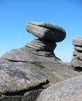
5 Tectonic Forces: Folding, Faulting and Volcanism Folding: compression FOLDING Faulting: fracture, stress Volcanism: molten material to surface FAULT ZONES VOLCANISM The San Andreas Fault is an example of a primary fault zone with hundreds of other faults associated with it. MT ST HELENS Explosive Earthquakes occur when built-up stress is relieved along a section of the fault. The shaking (quaking) of the ground is a result of stress release. The FOCUS of an earthquake is where the stress is released along the fault. The EPICENTER of an earthquake is the geographic coordinates at the surface directly above the focus. Gentle COLUMBIA PLATEAU HAWAII VOLCANO NP Gradational Forces Gradational or reducing forces wear away the land surface. There are 3 major categories: 1. Weathering: change in place. 2. Mass Wasting: loosening and movement under the force of gravity. 3. Erosion: friction, movement and deposition (occurring all at the same time) creates new shapes. Gradational Forces WEATHERING: a change in place in reaction to exposure to air, water and temperature. Happens in 2 ways: 1. Mechanical weathering or disintegration crumbling and fragmentation frost action, crystallization, root action 2. Chemical weathering or decomposition decay and separation of parts oxidation, hydrolysis, carbonization


 MASS WASTING: loosening and movement down slope under")


, widening the valley.")
6 Soils Gradational Forces Soil formation: Result of a very long period of mechanical and chemical weathering. Air, water and heat break down bedrock and organic material and release nutrients. Soil development is slope dependent. Soil Horizons: layers of the soil were certain conditions prevail. Bedrock (parent material) MASS WASTING: loosening and movement down slope under the force of gravity. - landslides - rock slides - mud flows - soil creep -slump Stability of slopes can be affected by natural events and human actions Gradational Forces EROSION: Combination of friction, movement and deposition occurring at the same time that creates new shapes: Take-Move-Place Agents of erosion are: - running water - moving ice -wind - waves -currents Take-Move-Place Moving Water and Valley Shapes V-shape Valley Downward cutting by running water is faster than lateral cutting, deepening the valley. U-shape Valley When water flow is weak it cannot cut downward. Looping rivers cut laterally (side to side), widening the valley River Meander Diagram Moving Ice and Glacial Landscapes <<<<mountain glacier and its features TAKE --- MOVE --- PLACE 35 continental glacier and its features. >>>> Long Island was at the edge of the last continental glacier. Most of the named features on the diagram are found on LI. 6


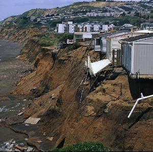

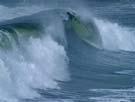
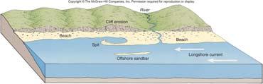
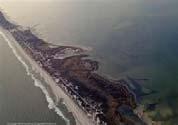
7 Wind Formed Landscapes Wave Action Landscapes Wind is a sandblaster! Longshore Currents TAKE --- MOVE --- PLACE N E X T LANDFORMS and LAND USE Coastal landscapes created by long shore currents
Geologic Influences GEOLOGIC CYCLE. Definitions. PART II: People and their 3/27/2018. GEOG 101 Part II People and their
 R E M I N D E R S Two required essays are due by March 27, 2018. A third may be used for extra credit in place of a Think Geographically essay. ESSAY TOPICS (choose any two): Contributions of a noted geographer,
Extra Credit for Exam II
 R E M I N D E R S Two required essays are due by Tuesday, Oct. 30, 2018. (A third essay may be used for extra credit in place of a Think Geographically essay.) ESSAY TOPICS (choose any 2): Contributions
R E M I N D E R S. q Atlas Extra Credit for Exam II: Now available on the Course Home Page Handouts Section. Blue scantron sheet is due March 29, 2019
 R E M I N D E R S v Two required essays are due by April 9, 2019. Ø A third may be used for extra credit in place of a Think Geographically essay. ESSAY TOPICS (choose any two): Contributions of a noted
TAKE HOME EXAM 8R - Geology
 Name Period Date TAKE HOME EXAM 8R - Geology PART 1 - Multiple Choice 1. A volcanic cone made up of alternating layers of lava and rock particles is a cone. a. cinder b. lava c. shield d. composite 2.
Tuesday, September 05, 2017 Planet Earth
 Tuesday, September 05, 2017 Planet Earth Objective: Describe the solar system and Earth s location in it. Identify Earth s shape. Discuss Earth s structure. List Earth s landforms Do Now: What is a compass
UNIT 3 GEOLOGY VOCABULARY FLASHCARDS THESE KEY VOCABULARY WORDS AND PHRASES APPEAR ON THE UNIT 3 CBA
 UNIT 3 GEOLOGY VOCABULARY FLASHCARDS THESE KEY VOCABULARY WORDS AND PHRASES APPEAR ON THE UNIT 3 CBA A map that shows Earth s Topographic Map surface topography, which is Earth s shape and features Contour
A physical feature of the Earth s surface
 Earth s Landforms A physical feature of the Earth s surface A physical feature of the Earth s surface LANDFORM Highest of Earth s physical features Highest of Earth s physical features MOUNTAIN Low area
8 th Grade Science Plate Tectonics and Topography Review
 8 th Grade Science Plate Tectonics and Topography Review #1 Scientists believe that the land masses of Earth were once joined together as one supercontinent called. A: Australia B: Wegner C: Pangaea D:
Physical Geography A Living Planet
 Physical Geography A Living Planet The geography and structure of the earth are continually being changed by internal forces, like plate tectonics, and external forces, like the weather. Iguaçu Falls at
deep within the planet. They are also shaped by conditions on the planet s surface. In
 Chapter 4 Landforms, Water, and Natural Resources Earth is home to many different types of landforms. These landforms are shaped by forces deep within the planet. They are also shaped by conditions on
PALEOGEOGRAPHY of NYS. Definitions GEOLOGIC PROCESSES. Faulting. Folding 9/6/2012. TOPOGRAPHIC RELIEF MAP of NYS GRADATIONAL TECTONIC
 TOPOGRAPHIC RELIEF MAP of NYS PALEOGEOGRAPHY of NYS Prof. Anthony Grande AFG 2012 Definitions GEOLOGIC PROCESSES Geography: study of people living on the surface of the earth. Geology: the scientific study
Section 1: Earth s Interior and Plate Tectonics Section 2: Earthquakes and Volcanoes Section 3: Minerals and Rocks Section 4: Weathering and Erosion
 Section 1: Earth s Interior and Plate Tectonics Section 2: Earthquakes and Volcanoes Section 3: Minerals and Rocks Section 4: Weathering and Erosion Key Terms Crust Mantle Core Lithosphere Plate Tectonics
Geosphere Final Exam Study Guide
 Geosphere Final Exam Study Guide Chapter 1 Intro to Earth Systems 1. Name and describe Earth s 4 major spheres Geosphere-- nonliving, mostly solid rock divided into crust, mantle, and core Atmosphere a
Social Studies 9 UNIT 2 GEOGRAPHIC INFLUENCES ON IDENTITY: PLACE AND PEOPLE
 Social Studies 9 UNIT 2 GEOGRAPHIC INFLUENCES ON IDENTITY: PLACE AND PEOPLE The Structure of the Earth To understand the forces that create Canada's physical landscape we must understand the structure
Earth Movement and Resultant Landforms
 Earth Movement and Resultant Landforms Structure of the Earth Lithosphere : earth s crust Asthenosphere : upper mantle zone where material is near its melting point & acts almost like liquid (appprox.
MARINE GEOLOGY & GEOGRAPHY
 MARINE GEOLOGY MARINE GEOLOGY & GEOGRAPHY Marine Geology 4 LAYERS OF THE EARTH CRUST THICKNESS: VARIES BETWEEN OCEAN & CONTINENTS 5-40 KM STATE: SOLID ELEMENTS: SILICON, ALUMINUM, CALCIUM, SODIUM, POTASSIUM
Earth s Structure and Surface
 Earth s Structure and Surface Structure of the Earth The earth is thought have originated about 4.5 billion years ago from a cloud or clouds of dust. The dust was the remains of a huge cosmic explosion
Marine Science and Oceanography
 Marine Science and Oceanography Marine geology- study of the ocean floor Physical oceanography- study of waves, currents, and tides Marine biology study of nature and distribution of marine organisms Chemical
Plate Tectonics Tutoiral. Questions. Teacher: Mrs. Zimmerman. Plate Tectonics and Mountains Practice Test
 Teacher: Mrs. Zimmerman Print Close Plate Tectonics and Mountains Practice Test Plate Tectonics Tutoiral URL: http://www.hartrao.ac.za/geodesy/tectonics.html Questions 1. Fossils of organisms that lived
A Living Planet. Chapter PHYSICAL GEOGRAPHY. What you will learn in this chapter. Summary of the chapter
 QUIT Main Ideas What you will learn in this chapter Summary Summary of the chapter Test your geographic knowledge by playing the. Main Ideas Section 1: The Earth Inside and Out The earth is the only habitable
PLATE TECTONICS REVIEW GAME!!!!
 PLATE TECTONICS REVIEW GAME!!!! Name the four layers of the earth - crust - mantle - outer core - inner core Which part of Earth s structure contains tectonic plates? LITHOSPHERE Name one reason why the
Earth and Space Science Semester 2 Exam Review. Part 1. - Convection currents circulate in the Asthenosphere located in the Upper Mantle.
 Earth and Space Science 2015 Semester 2 Exam Review Part 1 Convection -A form of heat transfer. - Convection currents circulate in the Asthenosphere located in the Upper Mantle. - Source of heat is from
GO ON. Directions: Use the diagram below to answer question 1.
 d i a g n o s t i c t e s t : e a r t h a n d s p a c e s c i e n c e question 1. 1. What is the correct order (starting from the surface) of Earth s layers? A crust, outer core, inner core, mantle B mantle,
FORCES ON EARTH. An investigation into how Newton s Laws of Motion are applied to the tectonic activity on Earth.
 FORCES ON EARTH An investigation into how Newton s Laws of Motion are applied to the tectonic activity on Earth. GEOLOGY Geologists scientists who study the forces that make and shape the Earth Geologists
MARINE GEOLOGY & GEOGRAPHY
 MARINE GEOLOGY & GEOGRAPHY Bathymetry BATHYMETRY BATHYMETRY THE UNDERWATER EQUIVALENT TO TOPOGRAPHY THE STUDY OF WATER DEPTH A BATHYMETRIC MAP SHOWS FLOOR RELIEF OR TERRAIN AS CONTOUR LINES Bathymetry
Directed Reading. Section: How Mountains Form MOUNTAIN RANGES AND SYSTEMS. Skills Worksheet
 Skills Worksheet Directed Reading Section: How Mountains Form 1. How high is Mount Everest? a. about 1980 km above sea level b. more than 8 km below sea level c. more than 8 km above sea level d. more
TEST NAME:Geology part 1 TEST ID: GRADE:06 - Sixth Grade SUBJECT:Life and Physical Sciences TEST CATEGORY: My Classroom
 TEST NAME:Geology part 1 TEST ID:1542715 GRADE:06 - Sixth Grade SUBJECT:Life and Physical Sciences TEST CATEGORY: My Classroom Geology part 1 Page 1 of 6 Student: Class: Date: 1. The picture below shows
ARE YOU READY TO THINK? Look at the first slide THINK PAIR SHARE!
 ARE YOU READY TO THINK? Look at the first slide THINK PAIR SHARE! WHAT PROMINENT FEATURE CAN YOU IDENTIFY IN THIS PICTURE? What do you think the different colors represent? Who might find such a picture
8 th Grade Campus Assessment- NSMS Plate Tectonics
 1. A group of students were discussing plate tectonics in their science class. All of the following statements about the tectonic plates are incorrect EXCEPT: A. The Eurasian Plate consists of the Asian
The Structure of the Earth and Plate Tectonics
 The Structure of the Earth and Plate Tectonics Structure of the Earth The Earth is made up of 4 main layers: Inner Core Outer Core Mantle Crust Crust Mantle Outer core Inner core The Crust This is where
A) B) C) D) 4. Which diagram below best represents the pattern of magnetic orientation in the seafloor on the west (left) side of the ocean ridge?
 B) C) D) 4. Which diagram below best represents the pattern of magnetic orientation in the seafloor on the west (left) side of the ocean ridge?") 1. Crustal formation, which may cause the widening of an ocean, is most likely occurring at the boundary between the A) African Plate and the Eurasian Plate B) Pacific Plate and the Philippine Plate C)
1. Crustal formation, which may cause the widening of an ocean, is most likely occurring at the boundary between the A) African Plate and the Eurasian Plate B) Pacific Plate and the Philippine Plate C)
CONTENT. A. Changes in the Crust Facts Changes Construction and Destruction. B. Continental Drift What is it? Evidence
 Name Earth Science Date Period TOPIC THE DYNAMIC EARTH CONTENT A. Changes in the Crust Facts Changes Construction and Destruction B. Continental Drift What is it? Evidence C. Theory of Plate Tectonics
Full file at
 Chapter 2 PLATE TECTONICS AND PHYSICAL HAZARDS MULTIPLE-CHOICE QUESTIONS 1. What direction is the Pacific Plate currently moving, based on the chain of Hawaiian Islands with only the easternmost island
The Structure of the Earth and Plate Tectonics
 The Structure of the Earth and Plate Tectonics Agree or Disagree? 1. The Earth if made up of 4 different layers. 2. The crust (where we live) can be made of either less dense continental crust or the more
Plate Boundaries & Resulting Landforms
 Plate Boundaries & Resulting Landforms Divergent Plate Boundaries (plates being pulled apart) Type: oceanic plates Description: rising magma gently lifts the crust creating a ridge. The flow of convection
Ch 17 Plate Tectonics Big Idea: Most geologic activity occurs at the boundaries between plates.
 Ch 17 Plate Tectonics Big Idea: Most geologic activity occurs at the boundaries between plates. 17.1 Drifting Continents 17.2 Seafloor Spreading 17.3 Plate Boundaries 17.4 Causes of Plate Motions Learning
Ch. 9 Review. Pgs #1-31 Write Questions and Answers
 Ch. 9 Review Pgs. 356-357 #1-31 Write Questions and Answers 356-357 #1-5 Answers 1. The layer of the upper mantle that can flow is the: A - Asthenosphere 2. Most scientists rejected Wegener s theory of
Movement of the Earth s Crust: Formation of: Mountain s Plateau's and Dome s
 Movement of the Earth s Crust: Formation of: Mountain s Plateau's and Dome s References Information taken from several places including Prentice Hall Earth Science: @ http://www.eram.k12.ny.us/education/components/docmgr/default.php?sectiondetaili
I. Earth s Layers a. Crust: Earth s outside layer. Made of mostly rock. i. Continental: er; made of mostly granite, forms the continents and shallow
 I. Earth s Layers a. Crust: Earth s outside layer. Made of mostly rock. i. Continental: er; made of mostly granite, forms the continents and shallow sea beds, floats! ii. Oceanic: er; dense rock such as
Continental Drift. & Plate Tectonics
 Continental Drift & Plate Tectonics Alfred Wegener, a German scientist, proposed the hypothesis of CONTINENTAL DRIFT, in 1912. Hypothesis stated: All Earth s continents were once a single landmass (Pangaea)
Full file at
 Essentials of Oceanography, 10e (Trujillo/Keller) Chapter 2 Plate Tectonics and the Ocean Floor Match the term with the appropriate phrase. You may use each answer once, more than once or not at all. A)
Unit 4 - Water. Earth s Interior. Earth s Interior. Continental Drift. Continental Drift. Continental Drift. Crust. Mantle. Core.
 Unit 4 - Water How did the oceans form? What special adaptations do saltwater organisms have? Where does our water come from? How do humans affect the Earth s water? Crust Rigid outer shell of Earth Oceanic
Outcome C&D Study Guide
 Name: Class: Outcome C&D Study Guide Identify the layers of Earth s interior Lithosphere the upper most layer of the earth that includes the crust and the hard outer mantle. It is fractured into tectonic
Earth s Changing Surface
 Earth s Changing Surface Earthquakes and Volcanoes Key Concepts What causes earthquakes? What causes volcanoes to form? How do earthquakes and volcanoes change Earth s surface? What do you think? Read
10. Paleomagnetism and Polar Wandering Curves.
 Map of ocean floor Evidence in Support of the Theory of Plate Tectonics 10. Paleomagnetism and Polar Wandering Curves. The Earth's magnetic field behaves as if there were a bar magnet in the center of
4 Layers of the earth 7 main plates of the earth 3 main plate boundaries 2 types of crust 3 main features of plate tectonics 3 main theorists and
 4 Layers of the earth 7 main plates of the earth 3 main plate boundaries 2 types of crust 3 main features of plate tectonics 3 main theorists and theories Human interaction The Earth is made up of 3 main
MAR110 Lecture #3 Ocean Bathymetry / Plate Tectonics
 1 MAR110 Lecture #3 Ocean Bathymetry / Plate Tectonics Ocean Basin Geographic Zones The geographic zones of the North Atlantic are identified in the bird s eye view of the sea floor above. Below is shown
Ch 9.1 Notes. Objective: Be able to explain the theory of plate tectonics and be able to explain evidence that supports it.
 Ch 9.1 Notes Objective: Be able to explain the theory of plate tectonics and be able to explain evidence that supports it. Pangaea Alfred Wegener proposed that land on Earth formed a single, huge landmass.
WHAT IS THE EARTH MADE OF? LITHOSPHERE AND HYDROSPHERE
 UNIT 8 WHAT IS THE EARTH MADE OF? LITHOSPHERE AND HYDROSPHERE TABLE OF CONTENTS 1 THE STRUCTURE OF THE EARTH... 2 2 THE FORMATION OF THE RELIEF: INTERNAL AND EXTERNAL FORCES.... 2 2.1 Internal forces:
Plate Tectonics: A Unifying Theory
 Plate Tectonics: A Unifying Theory What is Plate Tectonics? - 7 large tectonic plates and many smaller ones that break up the lithosphere - Plates are brittle and float on asthenosphere and glide past
Forces That Shape Earth. How do continents move? What forces can change rocks? How does plate motion affect the rock cycle?
 Forces That Shape Earth How do continents move? What forces can change rocks? How does plate motion affect the rock cycle? Plate Motion Mountain ranges are produced by plate tectonics. The theory of plate
12. The diagram below shows the collision of an oceanic plate and a continental plate.
 Review 1. Base your answer to the following question on the cross section below, which shows the boundary between two lithospheric plates. Point X is a location in the continental lithosphere. The depth
4 Deforming the Earth s Crust
 CHAPTER 7 4 Deforming the Earth s Crust SECTION Plate Tectonics BEFORE YOU READ After you read this section, you should be able to answer these questions: What happens when rock is placed under stress?
Plate Tectonics Practice Test
 Plate Tectonics Practice Test 1. What is the main idea Alfred Wegner proposed in the Theory of Continental Drift that he published in 1915? a. The continents float on a liquid layer that allows them to
Lab 1: Plate Tectonics April 2, 2009
 Name: Lab 1: Plate Tectonics April 2, 2009 Objective: Students will be introduced to the theory of plate tectonics and different styles of plate margins and interactions. Introduction The planet can be
water erosion lithosphere Describe the process of erosion and deposition. chemical weathering Dissolving limestone is an example of.
 At one time, there was one large island off the coast of Mississippi and now it is two separate islands. What caused the island to be split into two? water erosion The crust and the top part of the upper
Shape Earth. Plate Boundaries. Building. Building
 Chapter Introduction Lesson 1 Lesson 2 Lesson 3 Lesson 4 Chapter Wrap-Up Forces That Shape Earth Landforms at Plate Boundaries Mountain Building Continent Building How is Earth s surface shaped by plate
5. Convergent boundaries produce a relatively low number of earthquakes compared to other boundaries. a. True
 1. Earth s crust is thinner than its mantle. ANSWER: True 2. The concept of isostacy states that high-density rock will stand higher than low-density rock, which explains the formation of subduction zones.
Social Studies. Chapter 2 Canada s Physical Landscape
 Social Studies Chapter 2 Canada s Physical Landscape Introduction Canada s geography its landforms and climate - has a great impact on Canadians sense of identity. Planet Earth The earth is divided into
Name: Answer Key Date: Period:
 Name: Answer Key Date: Period: Earth Science Final Exam Study Guide Ch 1: Mapping 1. On the global grid, the equator is at 0 degrees. Is the equator a line of longitude or latitude? Latitude 2. What type
The Theory of Continental Drift. Continental Drift Discovery
 The Theory of Continental Drift Continental Drift Discovery The World ALFRED WEGENER THEORY OF CONTINENTAL DRIFT Found evidence for PANGAEA and proposed the theory of continental drift. Continental Drift
Plate Tectonics. Continental Drift Sea Floor Spreading Plate Boundaries
 Plate Tectonics Continental Drift Sea Floor Spreading Plate Boundaries Continental Drift 1915, Alfred Wegener - Pangea hypothesis: suggested Earth s continents were part of a large super-continent 200
Seas. A sea is a part of an ocean that is nearly surrounded by water. The Mediterranean, Arctic and Black Sea are really part of the Atlantic Ocean.
 Exploring the Ocean Since ancient times people have studied the ocean such as waters and ocean floor It provides food and services, and serves as a route for trade and travel The World s Oceans 71% of
Plate Tectonics. Earth has distinctive layers - Like an onion
 Plate Tectonics Earth has distinctive layers - Like an onion Earth s Interior Core: Metallic (Iron, Nickel) Inner (hot, solid, dense, Iron, Nickel) Outer (cooler, liquid, less dense) Crust (outermost layer):
Plate Tectonics. Structure of the Earth
 Plate Tectonics Structure of the Earth The Earth can be considered as being made up of a series of concentric spheres, each made up of materials that differ in terms of composition and mechanical properties.
Do Now: Vocabulary: Objectives. Vocabulary: 1/5/2016. Wegener? (Can they move?) the idea that continents have moved over time?
 the idea that continents have moved over time?") Do Now: 1. Who was Alfred Wegener? 2. What was Pangaea? 3. Are continents fixed? (Can they move?) 4. What evidence supports the idea that continents have moved over time? Objectives What evidence suggests
Do Now: 1. Who was Alfred Wegener? 2. What was Pangaea? 3. Are continents fixed? (Can they move?) 4. What evidence supports the idea that continents have moved over time? Objectives What evidence suggests
In 1912 Alfred Wegener proposed Continental Drift the continents have moved over time the continents were part of one giant landmass named Pangaea.
 Plate Tectonics In 1912 Alfred Wegener proposed Continental Drift the continents have moved over time the continents were part of one giant landmass named Pangaea. Pangaea Landmass movements over millions
Physical Geography. Physical Geography. Physical Landscape I of the United States and Canada. Definitions. Physical Geography GEOLOGIC PROCESSES
 Physical Landscape I of the United States and Canada Physical Geography Physical landscape (natural environment) sets the stage for human use (the cultural landscape). Prof. Anthony Grande AFG 2016 Landforms
Chapter. Graphics by Tasa Graphic Arts. Inc.
 Earth Chapter Plate Science 9 Tectonics Graphics by Tasa Graphic Arts. Inc. 1 I. Earth s surface is made up of lithospheric plates. A. Lithospheric plates are composed of the crust and part of the upper
Ocean Floor. Continental Margins. Divided into 3 major regions. Continental Margins. Ocean Basins. Mid-Ocean Ridges. Include:
 Ocean Floor Divided into 3 major regions Continental Margins Ocean Basins Mid-Ocean Ridges Continental Margins Include: Continental Shelves Continental Slopes Continental Rise 1 Continental Shelves Part
2. A rock cycle diagram is shown below. Which rock layer most likely contains fossils of the most recently evolved organisms?
 Do Not Write On Test - You Will Fail 1. The picture below shows a model of the rock cycle. 3. Shale is a sedimentary rock that can be metamorphosed into slate by A. cementation. B. chemical weathering.
core mantle crust the center of the Earth the middle layer of the Earth made up of molten (melted) rock
 rock") core the center of the Earth mantle the middle layer of the Earth made up of molten (melted) rock crust the surface layer of the Earth that includes the continents and oceans 1 continental drift the theory
core the center of the Earth mantle the middle layer of the Earth made up of molten (melted) rock crust the surface layer of the Earth that includes the continents and oceans 1 continental drift the theory
Plate Tectonics CHAPTER 17
 Plate Tectonics CHAPTER 17 Layers of the Earth A. Crust- solid, 5-70 km thick Moho Two Types of Crust: Oceanic- ocean floor, more dense then because of more iron Continental-dry land (mostly silicates
Moho (Mohorovicic discontinuity) - boundary between crust and mantle
 - boundary between crust and mantle") Earth Layers Dynamic Crust Unit Notes Continental crust is thicker than oceanic crust Continental Crust Thicker Less Dense Made of Granite Oceanic Crust Thinner More Dense Made of Basalt Moho (Mohorovicic
Earth Layers Dynamic Crust Unit Notes Continental crust is thicker than oceanic crust Continental Crust Thicker Less Dense Made of Granite Oceanic Crust Thinner More Dense Made of Basalt Moho (Mohorovicic
Benchmark 3 Science Study Guide S6E5 A-Crust, Mantle, Core 1. What happens to the temperature as you travel to the center of the Earth?
 Benchmark 3 Science Study Guide S6E5 A-Crust, Mantle, Core 1. What happens to the temperature as you travel to the center of the Earth? IT GETS HOTTER. 2. What happens to the density as you travel to the
Crustal Boundaries. As they move across the asthenosphere and form plate boundaries they interact in various ways. Convergent Transform Divergent
 Name: Date: Period: Plate Tectonics The Physical Setting: Earth Science CLASS NOTES Tectonic plates are constantly moving and interacting As they move across the asthenosphere and form plate boundaries
Name: Geology Study Guide Date:
 Name: Geology Study Guide Date: Vocabulary You must know the following terms and definitions: 1. bedrock- a solid rock mass that is undisturbed by environmental conditions on the Earth s crust 2. Continental
The structure of the Earth and how its motion creates the seasons. The landforms of the earth and the forces that shape the land.
 The structure of the Earth and how its motion creates the seasons. The landforms of the earth and the forces that shape the land. The role of wind and water in creating climate. The different climate and
Terrain Units PALEOGEOGRAPHY: LANDFORM CREATION. Present Geology of NYS. Detailed Geologic Map of NYS
 NYS TOPOGRAPHY Why so? PALEOGEOGRAPHY: LANDFORM CREATION Prof. Anthony Grande AFG 014 Present Geology of NYS Detailed Geologic Map of NYS Generalized Geology Detailed Geology Hot links to the fold out
Earth s Geological Cycle
 Earth s Geological Cycle What Are the Earth s Major Geological Processes? Main Processes: 1. Plate Tectonics 2. Rock Cycle 3. Soil Formation LITHOSPHERE The Earth s Structure Earth s Interior Core (Nickel
The Four Layers The Earth is composed of four different layers. The crust is the layer that you live on, and it is the most widely studied and
 Earth s Structure The Four Layers The Earth is composed of four different layers. The crust is the layer that you live on, and it is the most widely studied and understood. The mantle is much hotter and
The surface of the ocean floor is as varied as the land. The five major oceans, from largest to smallest, are
 11.1 Ocean Basins The surface of the ocean floor is as varied as the land. The five major oceans, from largest to smallest, are w the Pacific w the Atlantic w the Indian w the Southern w the Arctic The
MAR110 Lecture #4 Fundamentals of Plate Tectonics
 1 MAR110 Lecture #4 Fundamentals of Plate Tectonics The Ocean Sea Floor is formed Along the Mid-Ocean Ridge Spreading Centers The Ocean Sea Floor is destroyed in the Subduction Zones Figure 4.2 Convection
FORCES ON EARTH UNIT 3.2. An investigation into how Newton s Laws of Motion are applied to the tectonic activity on Earth.
 FORCES ON EARTH UNIT 3.2 An investigation into how Newton s Laws of Motion are applied to the tectonic activity on Earth. USE THESE NOTES: OUR HOME PLANET EARTH: What do you know about our planet? SO.HOW
Earthquakes & Volcanoes
 Earthquakes & Volcanoes Geology - the study of solid Earth, the rocks of which it is composed, and the processes by which they change geo = Earth; ology = study of Earth s Layers Plate Tectonics - the
Chapter 2 Geography. Getting to know Earth
 Chapter 2 Geography Getting to know Earth Our Solar System Sun is at the center of our solar system Contains a lot of Mass» Mass gives the Sun gravitational pull» This keeps the planets in our solar system
Isostasy and Tectonics Lab Understanding the Nature of Mobile Floating Lithospheric Plates
 Isostasy and Tectonics Lab Understanding the Nature of Mobile Floating Lithospheric Plates Crust Mantle Dynamics Introductory Geology Lab Ray Rector - Instructor Isostasy and Tectonics Laboratory Topics
The Two Types of Crust. Plate Tectonics. Physical Layers of the Earth. The Asthenosphere. The Lithosphere. Chemical Layers of the Earth
 Plate Tectonics A Reminder of Earth s Structure Two physical units of Earth that are important too! How the Earth Works Plate Tectonics Plate Boundaries Chemical Layers of the Earth Crust - low density
1.4 Notes: Plates Converge or Scrape Past Each Other Think About Tectonic Plates Push Together at Convergent Boundaries
 1.4 Notes: Plates Converge or Scrape Past Each Other Think About If new crust is created at divergent boundaries, why does the total amount of crust on Earth stay the same? Tectonic Plates Push Together
Earth Systems Science Chapter 7. Earth Systems Science Chapter 7 11/11/2010. Seismology: study of earthquakes and related phenomena
 Earth Systems Science Chapter 7 I. Structure of the Earth II. Plate Tectonics The solid part of the earth system includes processes, just like the atmosphere and oceans. However, the time scales for processes
4 th Grade PSI. Slide 1 / 107 Slide 2 / 107. Slide 3 / 107. Slide 4 / 107. Slide 5 / 107. Slide 6 / 107. The History of Planet Earth
 Slide 1 / 107 Slide 2 / 107 4 th Grade PSI The History of Planet Earth 2015-11-10 www.njctl.org Slide 3 / 107 Slide 4 / 107 The History of Planet Earth The Structure of Earth Rock Layers Fossils and Relative
24. Ocean Basins p
 24. Ocean Basins p. 350-372 Background The majority of the planet is covered by ocean- about %. So the majority of the Earth s crust is. This crust is hidden from view beneath the water so it is not as
PHYSICAL GEOGRAPHY General Information
 PHYSICAL GEOGRAPHY General Information By understanding the environment we can understand why one place is different or the same as another. See handout Geomorphology Geo --Land morph --Change ology --Study
Plate Tectonics Unit II: Plate Boundaries (3.5 pts)
") T. James Noyes, El Camino College Plate Tectonics Unit II: The Plate Boundaries (Topic 11A-2) page 1 Name: Section: Plate Tectonics Unit II: Plate Boundaries (3.5 pts) Plate Boundaries We will now discuss
T. James Noyes, El Camino College Plate Tectonics Unit II: The Plate Boundaries (Topic 11A-2) page 1 Name: Section: Plate Tectonics Unit II: Plate Boundaries (3.5 pts) Plate Boundaries We will now discuss
Unit 1: Earth as a System. Section 1: Plate Tectonics and the Rock Cycle
 Unit 1: Earth as a System Section 1: Plate Tectonics and the Rock Cycle Earth s Realms Earth is divided into 4 major realms: Atmosphere gases surrounding earth Hydrosphere - earth s supply of water Lithosphere
Chapter 10 - Geology. Earth s Structure, Geologic Hazards, and Soils
 Chapter 10 - Geology Earth s Structure, Geologic Hazards, and Soils Plate Tectonics Earth crust (or lithosphere) is broken up into plates that shift and slide around Asthenosphere (semi molten layer of
THE DYNAMIC EARTH NOTES. Scientists divide the Earth into 4 parts or spheres. What are these spheres?
 Hon Environmental Science THE DYNAMIC EARTH NOTES. Scientists divide the Earth into 4 parts or spheres. What are these spheres? 1. geosphere 2. atmosphere 3. hydrosphere 4. biosphere Now, describe each
In order to study Plate Tectonics, we must first
 TB Chapter 13 In order to study Plate Tectonics, we must first reorganize our layering system for the Earth: Old System 4 layers Crust (rigid) id) (rigid) Mantle (putty like) (semi rigid) Outer core (liquid)
Grade 9 Social Studies Canadian Identity. Chapter 2 Review Canada s Physical Landscape
 Grade 9 Social Studies Canadian Identity Chapter 2 Review Canada s Physical Landscape Name: Unit 1: Empowerment Terms (notes or textbook) 1. Core 2. Crust 3. Mantle 4. Magma 5. Continental drift 6. Plate
Earth / Environmental Science. Ch. 14 THE OCEAN FLOOR
 Earth / Environmental Science Ch. 14 THE OCEAN FLOOR The Blue Planet Nearly 70% of the Earth s surface is covered by the global ocean It was not until the 1800s that the ocean became an important focus