Advanced Workshop on Evaluating, Monitoring and Communicating Volcanic and Seismic Hazards in East Africa.
|
|
|
- Doreen Barber
- 5 years ago
- Views:
Transcription
1 Advanced Workshop on Evaluating, Monitoring and Communicating Volcanic and Seismic Hazards in East Africa August 2009 Eruptive Activity of Nyiragongo Volcano lessons learned: the scenarios of the contingency plan of the city of Goma Dario Tedesco University of Naples Caserta Italy
2 Dario Tedesco UNOPS - UGR Second University of Naples Environmental Sciences Eruptive Activity of Nyiragongo Volcano : lessons learned for Natural Disasters in North Kivu


3 Activitè avril 2009

4
5

6

7

8

9
10 Collaboration avec les Institutions Etrangeres Université de Naples 2 (I) Musèe d Afrique de Tervuren (B) Université de Luxembourg (L) Université de Florence (I) Inst. Nationale de Geophysique et Volcanologie (I) Université du Wisconsin (US) Universitè de Rochester (US) Columbia University (US) JPL/NASA (US) Université de Cambridge (UK) Societé Volcanologique de Geneve (S)
11 Identification of Possible Natural Hazards: Volcanic Eruptions Earthquakes Acid Rains (up to ph 0) Deadly Soil CO 2 Gas Emissions Poor Water Quality (Endemic Fluorosis) Killer Lake Man Made Hazards Lake Pollution Deforestation and Soil Avalanches/Landslides

12 Eruptive Scenarios of Nyamulagira and Nyiragongo Volcanoes Nyamulagira Scenario 1 Scenario 2 Nyiragongo - Scenario 1 - Scenario 2 Current Activity Unité de Gestion des Risques Volcaniques Contact: dtedesco@unina.it Prof. Dario Tedesco Second University of Naples (Italy) UNOPS Consultant Benoît Smets Royal Museum for Central Africa (Belgium)
13 Echelle d impact Probabilité d occurrence Négligeable Pas de morts, blessés multiples. Impact minimal sur la qualité de vie. Arrêt des installations / services de base pour moins de 24 heures. Moins de 10% de domages sévères sur les propriétés. Très probable Probabilité de près de 100% dans l année ou 100% de probabilité sur le type d eruption. Limité Quelques morts et blessés. Arrêt complet des installations/services de base pour moins d une semaine. Plus de 10% de dommages sévères sur les propriétés. Probable Entre 10% et 100% de probabilité dans l année, ou au moins une chance dans les dix prochaines années Critique Moins de 100 morts et blessés. Arrêt complet des installations/services de base pour au moins deux semaines. Plus de 25% de dommages sévères sur les propriétés. Possible Entre 1% et 10% de probabilité dans l année, ou au moins une chance dans les cent prochaines années Catastrophique Nombreux morts et blessés. Arrêt complet des installations/services de base pour au moins un mois. Plus de 50% de dommages sévères sur les propriétés. Peu Probable Moins de 1% de probabilité dans l année, ou moins d une chance dans les cent prochaines années


14 PROBABLE
15 Nyamulagira : scenario 1 PROBABLE Event: Fractures opening, important lava flows at west, north or east of the volcano, volcanic plume, scoria cones Area affected: Limited to the forest of Virunga National Park Population affected by the volcanic plume: Population in few kilometers around the eruptive site (mainly at west) Duration (estimation) Crisis (emergency period): several weeks to several months (up to 2 years) Post-emergency: ~3 months Rehabilitation: ~3 months

16 POSSIBLE
17 Nyamulagira : scenario 2 POSSIBLE Event: Fractures opening, important lava flows at south or west of the volcano, volcanic plume, scoria cones Area affected: Forest of the Virunga National Park, urban areas of Sake - Mubambiro, plus the Sake - Kitchanga & Goma - Sake road Population affected by the volcanic plume: Population few kilometers around the eruptive site (mainly on the south and south-western sides) Population affected by the lava flows: Sake - Mubambiro area (south) or less probably Kabalekasha - Kitchanga area (west) Duration (estimation) Crisis (emergency period): several weeks to several months (up to 2 years). Post-emergency: ~3 months up to few years (depending on the M of the event Rehabilitation: ~1 year or more (as above)

18 POSSIBLE

19 POSSIBLE
20 POSSIBILE
21 Nyiragongo : scenario 1 POSSIBLE Event: Opening fractures, lava flows, volcanic plume, scoria cones, phreato -magmatic explosion in case of fractures near the Lake Kivu Area affected: Area south of the volcano, Goma and vicinity, probably Gisenyi Population affected (estimation) Dead: ~200 Injured: ~2.000 Displaced: ~ Duration (estimation) Crisis (emergency period): ~1 week to months, depending on the M of the eruptive event Post-emergency: ~3 months to years (as above) Rehabilitation: ~1 year ~ x or? years


22 Poco Probabile
23 Nyiragongo : scenario 2 PEU PROBABLE Event: Fractures opening, lava flows, volcanic plume, scoria cones, probable phreato-magmatic explosions (depending on available ground water), new fractures near or within Lake Kivu Area affected: Area from south-west to south-east of the volcano, Goma and vicinity, Gisenyi Population affected (estimation) Dead: ~ or more, depending on the forecast Injured: ~ Displaced: ~ (the whole populations of the great Goma and Gisenyi) Duration (estimation) Crisis (emergency period): several months to years Post-emergency: ~6/12 months ~several years or? Rehabilitation: ~several years may be impossible!
24 Current activity and international expertise Nyiragongo: permanently active (steady state (active) lava lake, slightly decreasing volcanic plume), relatively stable Nyamulagira: increasing fumarolic activity (desappeared in June) into the main crater, weak fumaroles in the 2006 eruptive site, increasing seismic activity but no yet real signs of a close event. Possible eruptive event in the next months may be more, one years. GVO (study and monitoring of volcanoes) and UGR (hazard and risk management) collaboration with international experts to help monitoring volcanoes, for training sessions, for scientific studies and for hazard assessment and mitigation. An international scientific community of experts for Virunga volcanoes already exists and actively collaborate with GVO and UGR in their respective tasks. - Italy (Second University of Naples, University of Florence, INGV) - Belgium (Royal Museum for Central Africa) - Luxembourg (National Museum of Natural History, University of Luxembourg) - USA (JPL/NASA, University of Wisconsin, Columbia University, Rochester University) - UK (University of Cambridge) - Switzerland (Societé Volcanologique de Geneva).
25 Current activity

26 New volcanological map

27 Lava Flows Simulations First attempt the real question is: from where the lava will start flowing next time? Specific monitoring systems are badly needed. Favalli et al., 2009; Chirico et al., 2009

28 Favalli et al., 2009; Chirico et al., 2009
29 The UGR and OVG also works in close collaborations with foreign Institutions : - Seismic data (GVO and INGV-Rome) - GPS and tilt stations (ground deformation) Go-Risk - Radar interferometry (ground deformation) Go-Risk - Geochemical studies of water and gas (GVO Naples and Florence Un, Lux. Un, USA) - Distant crater CO 2 gas emanations (GVO Na USA) - Study of plume impact on health (Na & Fi Univ.) - Lake Kivu Hazard(s) (Naples, Florence, USA) - Hazard mapping Go-Risk, Naples - Remote sensing (plume) (INGV, Naples, Cambridge UK, USA) - Satellite Imagery (Lux., JPL / NASA)

30 Æ Wrong alert!!!

31 Thermal monitoring of volcanoes by MODIS Thermal alerts from 6 th April to 6 th May, 2009 Source : Thermal alerts linked to the active lava lake of Nyiragongo (usual kind of alert for this volcano)
Cooperation on Congo Volcanic and Environmental Risks
 Eos, Vol. 88, No. 6, 7 April 7 VOLUME 88 NUMBER 6 7 APRIL 7 EOS, TRANSACTIONS, AMERICAN GEOPHYSICAL UNION PAGES 77-88 Cooperation on Congo Volcanic and Environmental Risks PAGES 77,8 On 7 January, the
Supporting the response to the 2018 lower East Rift Zone and summit collapse at Kīlauea Volcano, Hawaiʻi
 Hawaiʻi Supersite success story Supporting the response to the 2018 lower East Rift Zone and summit collapse at Kīlauea Volcano, Hawaiʻi Since 1983, Kīlauea Volcano, on the Island of Hawaiʻi, has actively
ISSUES MANAGEMENT AND DEVELOPMENT OF GEOTHERMAL ENERGY IN THE WESTERN BRANCH OF THE AFRICAN RIFT SYSTEM: CASE OF THE DEMOCRATIC REPUBLIC OF CONGO
 ISSUES MANAGEMENT AND DEVELOPMENT OF GEOTHERMAL ENERGY IN THE WESTERN BRANCH OF THE AFRICAN RIFT SYSTEM: CASE OF THE DEMOCRATIC REPUBLIC OF CONGO BY KASEREKA MAHINDA Célestin Geophysist Secrétaire Permanent,
A - Piton de la Fournaise activity
 OVPF-IPGP August 2018 Page 1/7 Monthly bulletin of the Piton de la Fournaise Volcanological Observatory ISSN ISSN 2610-5101 A - Piton de la Fournaise activity PITON DE LA FOURNAISE (VNUM #233020) Latitude:
IOM s Disaster Risk Reduc on in North Kivu
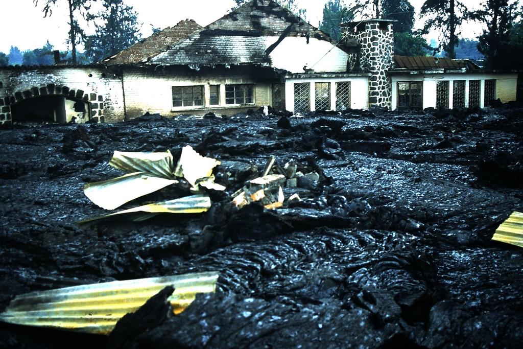
 IOM DEMOCRATIC REPUBLIC OF THE CONGO IOM s Disaster Risk Reduc on in North Kivu SITUATION UPDATE REPORT 01 October 2014 Figure 1a. The city of Goma a er the Nyiragongo volcanic erup on of 17 January 2002.
A - Piton de la Fournaise activity
 OVPF-IPGP November 2018 Page 1/7 Monthly bulletin of the Piton de la Fournaise Volcanological Observatory ISSN ISSN 2610-5101 A - Piton de la Fournaise activity PITON DE LA FOURNAISE (VNUM #233020) Latitude:
A - Piton de la Fournaise activity
 OVPF-IPGP September 2018 Page 1/10 Monthly bulletin of the Piton de la Fournaise Volcanological Observatory ISSN ISSN 2610-5101 A - Piton de la Fournaise activity PITON DE LA FOURNAISE (VNUM #233020) Latitude:
Was the February 2008 Bukavu seismic sequence associated with magma intrusion?
 Was the February 2008 Bukavu seismic sequence associated with magma intrusion? N. d Oreye, C. Lucas National Museum of Natural History, Luxembourg nicolas.doreye@ecgs.lu P. Gonzalez, J. Fernández Univ.
FINAL EXAM December 20 th, here at 1:00 3:00 pm
 FINAL EXAM December 20 th, here at 1:00 3:00 pm REVIEW SESSION December 11 th at 6:00-7:30 pm Morrill I Auditorium (Room N375) Same as last time Don t forget your online course evaluations! Major Volcanic
Geochemical study of thermal springs in Eastern D.R. Congo
 Geochemical study of thermal springs in Eastern D.R. Congo Mambo Vikandy S.*, Kasereka Mahinda**, Yalire Mapendano** and Wafula Mifundu** * Faculty of Science, Université Officielle de Ruwenzori (UOR),
Situation Report. Situation Overview. Volcanic Activity Ambae & Ambrym. Situation Report 08. Time & Date 17:00 18 th October 2017
 Situation Report Response Name Volcanic Activity Ambae & Ambrym Situation Report 08 Time & Date 17:00 18 th October 2017 Reporting period 18/10/2017 Provinces affected Penama, Sanma, Malampa Attachment(s)
( ) USGS (United States Geological Survey) Watch Green. Normal. alert level 1 Normal
 USGS (United States Geological Survey) Watch Green. Normal. alert level 1 Normal") (200610.1) USGS (United States Geological Survey) 1014 alert level 1 Normal Watch Green Normal USGS WARNING WATCH ADVISORY NORMAL SUMMARY OF VOLCANIC-ALERT LEVELS Highly hazardous eruption underway or
(200610.1) USGS (United States Geological Survey) 1014 alert level 1 Normal Watch Green Normal USGS WARNING WATCH ADVISORY NORMAL SUMMARY OF VOLCANIC-ALERT LEVELS Highly hazardous eruption underway or
D.R. Congo. Vikandy S. Mambo Université Officielle de Ruwenzori, Butembo, North-Kivu, Eastern Congo
 Geothermal Exploration in D.R. Congo Vikandy S. Mambo Université Officielle de Ruwenzori, Butembo, North-Kivu, Eastern Congo 1 Geochemical Study of Thermal Springs in Eastern D.R. Congo Mambo Vikandy S.,
Copernicus Overview and Emergency Management Service
 Copernicus Overview and Emergency Management Service Frédéric BASTIDE European Commission Open informal session of the United Nations Inter-Agency Meeting on Outer Space Activities 12 March 2013, Geneva
Copernicus Overview. Major Emergency Management Conference Athlone 2017
 Copernicus Overview Major Emergency Management Conference Athlone 2017 Copernicus is a European programme implemented by the European Commission. The services address six thematic areas: land, marine,
Experimental research into emission of ultra fine dusts as harbingers of volcanic seismic events
 Experimental research into emission of ultra fine dusts as harbingers of volcanic seismic events F. Patania, A. Gagliano, F. Nocera & V. Lauretta Energy and Environment Division of D.I.I.M., Engineering
LECTURE #11: Volcanoes: Monitoring & Mitigation
 GEOL 0820 Ramsey Natural Disasters Spring, 2018 LECTURE #11: Volcanoes: Monitoring & Mitigation Date: 15 February 2018 I. What is volcanic monitoring? the continuous collection of one or more data sources
Committee on Earth Observation Satellites. The CEOS Volcano Demonstrator Rationale and Implementation
 Committee on Earth Observation Satellites The CEOS Volcano Demonstrator Rationale and Implementation Why focus on volcanoes? Over 300,000 people have been killed by volcanoes since the 1600s Globally,
Geospatial Information Management in the Americas: Lessons for the Post-2015 development agenda
 Geospatial Information Management in the Americas: Lessons for the Post-2015 development agenda Rolando Ocampo President, UN-GGIM: Americas October 2014 The integration of statistical and geographical
Volcanic Benefits & Forecasting
 Volcanic Benefits & Forecasting Review: https://www.youtube.com/watch?v=ydy28qtdyjy 1. Based on what we know about volcanoes, predict where you might you expect to see volcanoes in and around New Zealand?
68. Izu-Torishima. Summary. Latitude: 30 29'02" N, Longitude: '11" E, Elevation: 394 m (Ioyama) (Elevation Point) (68.
 (Elevation Point) (68.") 68. Izu-Torishima Latitude: 30 29'02" N, Longitude: 140 18'11" E, Elevation: 394 m (Ioyama) (Elevation Point) Izu-Torishima taken from southeast side on August 12, 2002. Courtesy of the Maritime Safety
68. Izu-Torishima Latitude: 30 29'02" N, Longitude: 140 18'11" E, Elevation: 394 m (Ioyama) (Elevation Point) Izu-Torishima taken from southeast side on August 12, 2002. Courtesy of the Maritime Safety
Aim: To be able to describe and explain techniques used to predict or reduce the impacts of volcanic eruptions in NAMED locations.
 C/W Qu: Can we predict volcanoes? 18/10/12 Aim: To be able to describe and explain techniques used to predict or reduce the impacts of volcanic eruptions in NAMED locations. Starter: Read and correct the
NSF-MARGINS Expedition to Anatahan Volcano March 2005
 1 NSF-MARGINS Expedition to Anatahan Volcano March 2005 According to the Emergency Management Office (EMO) report distributed in February 2005, the third historical eruption of Anatahan began on January
Jeopardy. Final Jeopardy $100 $100 $100 $100 $100 $200 $200 $200 $200 $200 $300 $300 $300 $300 $400 $400 $400 $500 $500 $500 $500 $500
 Jeopardy Earthquakes Volcanoes Tsunamis Wildfires Landslides/ Droughts $100 $100 $100 $100 $100 $200 $200 $200 $200 $200 $300 $300 $300 $300 $300 $400 $400 $400 $400 $400 $500 $500 $500 $500 $500 Final
Monthly Volcanic Activity Report (February 2016)
") Monthly Volcanic Activity Report (February 2016) Japan Meteorological Agency Azumayama (Alert Level: 2) Fumarolic activity at the Oana crater has remained at relatively high levels. Aerial observation
Monthly Volcanic Activity Report (February 2016) Japan Meteorological Agency Azumayama (Alert Level: 2) Fumarolic activity at the Oana crater has remained at relatively high levels. Aerial observation
Erupted and killed approximately 15,000 people 200 years ago
 1 2 3 4 5 6 7 8 Introduction to Environmental Geology, 5e Chapter 8 Volcanic Activity Volcanoes: summary in haiku form A volcano forms. Magma comes to the surface - explodes, if felsic. Case History: Mt.
Vulnerability mapping for sustainable hazard mitigation in the city of Bukavu, South Kivu DRCongo
 IAG/AIG REGIONAL CONFERENCE, 18th to 22nd Feb. 2011 Vulnerability mapping for sustainable hazard mitigation in the city of Bukavu, South Kivu DRCongo Sadiki Ndyanabo 1, Ine Vandecasteele 2, Jan Moeyersons
The Afar Rift Consortium
 The Afar Rift Consortium University of Bristol University of Oxford University of Cambridge British Geological Survey University of Rochester University of Auckland, NZ Opportunistic programme following
Name: Page 1. 2) What do increases and decreases in RSAM data indicate about magma movement inside the volcano?
 What do increases and decreases in RSAM data indicate about magma movement inside the volcano?") Name: Page 1 Living on the Edge Unit 5: SEISMOLOGISTS A report on the seismic activity must be prepared in order to assess and forecast future activity. Complete the following components of the seismology
Name: Page 1 Living on the Edge Unit 5: SEISMOLOGISTS A report on the seismic activity must be prepared in order to assess and forecast future activity. Complete the following components of the seismology
SCIENTIFIC RESEARCH AND EDUCATION IN THE AIR FORCE AFASES2017
 SCIENTIFIC RESEARCH AND EDUCATION IN THE AIR FORCE AFASES2017 PROBABILITY ASSESSMENT OF POSSIBLE VOLCANIC ASH CONTAMINATION FOR THE BULGARIAN AIRSPACE BY DEVELOPING OF EVENT TREE AND RISK MATRIX FOR HYPOTHETICAL
USGS Volcano Hazards Program
 USGS Volcano Hazards Program NAS Board on Earth Sciences and Resources May 12, 2014 Charlie Mandeville USGS Program Coordinator cmandeville@usgs.gov www.volcanoes.usgs.gov Volcano Hazards Program Mission:
Diverse deformation patterns of Aleutian volcanoes from InSAR
 Diverse deformation patterns of Aleutian volcanoes from InSAR Zhong Lu 1, Dan Dzurisin 1, Chuck Wicks 2, and John Power 3 U.S. Geological Survey 1 Cascades Volcano Observatory, Vancouver, Washington 2
Earthquake and Volcano Service
 Ref. Ares(2014)73773-15/01/2014 Earthquake and Volcano Service WP Leader: Istituto Nazionale di Geofisica e Vulcanologia (Italy) Contributors: NILU (Norway), EUCENTRE (Italy), GAMMA (Switzerland), IGAR
Degassing processes and recent activity at Volcán de Colima. Universidad de Colima, Mexico Corresponding author
 Degassing processes and recent activity at Volcán de Colima Nick Varley * & Gabriel Reyes Dávila Universidad de Colima, Mexico Corresponding author email: nick@ucol.mx Volcán de Colima is currently in
Thematic Session: IT Innovations Geospatial Approaches to Damage Assessment: The Example of Haiti Earthquake
 Thematic Session: IT Innovations Geospatial Approaches to Damage Assessment: The Example of Haiti Earthquake Date: 10/05/2011 Location: Geneva, Switzerland Name: Luca Dell Oro Title: Research Associate
Volcanic Monitoring in Long Valley, California. creating a ten-mile by twenty-mile caldera in the Eastern Sierra Nevada region of
 Jensen Grimmer G188 6/6/2013 Volcanic Monitoring in Long Valley, California Abstract: Around 760,000 years ago an explosive eruption shook the western United States creating a ten-mile by twenty-mile caldera
What is the Relationship between Pressure & Volume Change in a Magma Chamber and Surface Deformation at Active Volcanoes?
 SSAC-pv2007.QE522.PL1.1 What is the Relationship between Pressure & Volume Change in a Magma Chamber and Surface Deformation at Active Volcanoes? What factors control the magnitude of surface deformation?
The UN-GGIM: Europe core data initiative to encourage Geographic information supporting Sustainable Development Goals Dominique Laurent, France
 INSPIRE conference Strasbourg 6 September 2017 The UN-GGIM: Europe core data initiative to encourage Geographic information supporting Sustainable Development Goals Dominique Laurent, France Introduction
Monthly Volcanic Activity Report (November 2015)
") Monthly Volcanic Activity Report (November 2015) Japan Meteorological Agency Meakandake (Alert Level: 1) Alert level downgrade from 2 to 1 on 13 November A field survey conducted from 2 to 5 November showed
Monthly Volcanic Activity Report (November 2015) Japan Meteorological Agency Meakandake (Alert Level: 1) Alert level downgrade from 2 to 1 on 13 November A field survey conducted from 2 to 5 November showed
VOLCANO MONITORING PRACTICAL. Hazard alert levels established for communication at Mt. Pinatubo
 VOLCANO MONITORING PRACTICAL Predicting volcanic eruptions is a hazardous and stressful business. If an eruption has occurred and was not predicted then the volcanologists get the blame for not giving
Geothermal Potential Assessment in Northern Rwanda
 Geothermal Potential Assessment in Northern Rwanda 2 nd African Rift Geothermal Conference Entebbe, Uganda Ngaruye, Jean-Claude 1) Jolie, Egbert 2) 1) Rwanda Geology and Mining Authority, OGMR 2) Federal
Monthly Volcanic Activity Report (August 2015)
") Monthly Volcanic Activity Report (August 2015) Japan Meteorological Agency Meakandake (Alert Level: 2) Volcanic seismicity in shallow parts under the area around the Ponmachineshiri crater began to fluctuate
Monthly Volcanic Activity Report (August 2015) Japan Meteorological Agency Meakandake (Alert Level: 2) Volcanic seismicity in shallow parts under the area around the Ponmachineshiri crater began to fluctuate
Module 1, Investigation 3: Predicting Eruptions
 Module 1, Investigation 3: Predicting Eruptions Introduction Welcome! Volcanoes are either "active" or "extinct". Active means that the volcano has erupted during the past 10,000 years. It can also mean
Space Applications for Disaster Risk Reduction and Sustainable Development
 Space Applications for Disaster Risk Reduction and Sustainable Development Space Applications Section (SAS) ICT and Disaster Risk Reduction Division (IDD) UNESCAP Contents I. RESAP Activities 2016-2017
The new challenge of community-based environmental monitoring and information systems: the Citizens Obsrevatories Tito Scalo (PZ) 13 July 2016
 13 July 2016") The new challenge of community-based environmental monitoring and information systems: the Citizens Obsrevatories Tito Scalo (PZ) 13 July 2016 Involving citizens in environmental monitoring and awareness:
The new challenge of community-based environmental monitoring and information systems: the Citizens Obsrevatories Tito Scalo (PZ) 13 July 2016 Involving citizens in environmental monitoring and awareness:
Volcano Monitoring on a Regional Scale:
 Volcano Monitoring on a Regional Scale: Results from the CEOS Disaster Risk Management Volcano Pilot David Arnold 1 Juliet Biggs 1 Francisco Delgado 2 Matt Pritchard 2 Susi Ebmeier 1 Mike Poland 3 Simona
GSNL - Geohazard Supersites and Natural Laboratories. Biennial report for Candidate/Permanent Supersite. Hawaiʻi Supersite. Annex to report
 Introduction Biennial report for Candidate/Permanent Supersite Hawaiʻi Supersite Annex to 2014 2016 report During 2014 2016, the Hawaiʻi Supersite achieved a number of noteworthy results. This annex details
Emergency Management Service (EMS) mapping
 mapping") GMES Emergency Management Service (EMS) mapping Frédéric BASTIDE GMES unit, European Commission UN-SPIDER Expert Meeting: "Crowdsource Mapping for Disaster Risk Management and Emergency Response" 3-5 December,
GMES Emergency Management Service (EMS) mapping Frédéric BASTIDE GMES unit, European Commission UN-SPIDER Expert Meeting: "Crowdsource Mapping for Disaster Risk Management and Emergency Response" 3-5 December,
EXPLORE PLATE TECTONICS & MORE THROUGH GPS DATA. Shelley Olds, UNAVCO April 12, 2018 NGSS Webinar
 EXPLORE PLATE TECTONICS & MORE THROUGH GPS DATA Shelley Olds, UNAVCO April 12, 2018 NGSS Webinar Today s Outline Central question: How do we know the tectonic plates are still moving? -- What evidence
Haiti: Earthquake on January 12, 2010
 Geophysical Hazards and Plate Boundary Processes In Central America, Mexico and the Caribbean Haiti: Earthquake on January 12, 2010 Situation, achievements and perspective. Hotel La Condesa, Costa Rica
Progress Report: Sentinel Asia Success Story in the Philippines
 Progress Report: Sentinel Asia Success Story in the Philippines 3 rd Joint Project Team Meeting on the Sentinel Asia STEP-2 July 6-8, 2010 Hyatt Hotel, Manila, Philippines Renato U. Solidum Jr. Director
TOOLS FOR RISK MANAGEMENT Related to climate change
 TOOLS FOR RISK MANAGEMENT Related to climate change copyright CONTENT 1 CLIMATE CHANGE AND ENVIRONMENTAL STUDIES 2 METHODS AND TOOLS DEVELOPED BY EGIS For infrastructures For urban areas For crisis management
Agrometeorological activities in RHMSS
 Republic of Serbia Republic Hydrometeorological Service of Serbia Agrometeorological activities in RHMSS Department for applied climatology and agrometeorology www.hidmet.gov.rs Meteorological Observing
Chapter 3 HAZARD ASSESSMENT AND PREDICTION. 3.1 General principles
 Chapter 3 HAZARD ASSESSMENT AND PREDICTION 3.1 General principles For long-term planning of human settlements and investment in volcanic areas, it is useful, and indeed essential, to have some knowledge
Disaster Risk Reduction in Survey for Seismic Protection of MES
 Survey for Seismic Protection Ministry of Emergency Situations of Republic of Armenia Disaster Risk Reduction in Survey for Seismic Protection of MES Syuzanna Kakoyan Leading specialist at the Department
Kīlauea Volcano: Be a Volcanologist. Image Credit: Julien Millet / Unsplash. Final Project
 The Kīlauea Volcano: Be a Volcanologist Image Credit: Julien Millet / Unsplash Final Project Final Project The Kīlauea Volcano: Be a Volcanologist In this two-day project, students apply their previous
DIPLOMA IN DISASTER MANAGEMENT. (Non-Semester) (With effect from the academic year )
 (With effect from the academic year )") DIPLOMA IN DISASTER MANAGEMENT (Non-Semester) (With effect from the academic year 2013-14) Eligibility for the Course Candidate should have passed the Higher Secondary Examination conducted by the Board
DIPLOMA IN DISASTER MANAGEMENT (Non-Semester) (With effect from the academic year 2013-14) Eligibility for the Course Candidate should have passed the Higher Secondary Examination conducted by the Board
A century of experience: Training and knowledge transfer in Africa 30 years of activities: Past, present and future
 Royal Museum for central Africa A century of experience:1898-2012 Training and knowledge transfer in Africa 30 years of activities: Past, present and future Earth Sciences Field Geology Geodynamics Major
Recent Kilauea Status Reports, Updates, and Information Releases
 Page 1 of 15 deformation images timelapse movies maps Pu`u `O`o webcam July 21 webcam Recent Kilauea Status Reports, Updates, and Information Releases Kilauea Daily Update issued Feb 28, 2008 09:38 HST
The BEYOND Center of Excellence for monitoring natural disasters from space
 The BEYOND Center of Excellence for monitoring natural disasters from space Ioannis Papoutsis National Observatory of Athens Institute for Astronomy, Astrophysics, Space Applications & Remote Sensing MOWE-IT
Uses of free satellite imagery for Disaster Risk Reduction (DRR)
") Centre of Applied Geoscience, Disaster Risk Reduction Research Group, School of Earth and Environmental Science, University of Portsmouth, UK Uses of free satellite imagery for Disaster Risk Reduction
Centre of Applied Geoscience, Disaster Risk Reduction Research Group, School of Earth and Environmental Science, University of Portsmouth, UK Uses of free satellite imagery for Disaster Risk Reduction
Evidence for plate tectonics
 Evidence for plate tectonics See class powerpoint Printed tables 2x essay Qs markschemes Discuss/Evaluate the evidence for plate tectonics Discuss/evaluate the evidence for plate tectonics Essay: To what
and their risks A look at volcano risk for young students. Produced by the MED-SUV project.
 and their risks A look at volcano risk for young students. Produced by the MED-SUV project. Volcano Shapes: A volcano is a place (on Earth and OTHER PLANETS) where magma comes to the surface. This event
Recent activity. Current episode 12 years Transition between styles 4 periods of dome growth Since 2003, Vulcanian explosions (4 25 per day)
") Recent activity Current episode 12 years Transition between styles 4 periods of dome growth Since 2003, Vulcanian explosions (4 25 per day) 02 December 09 Explosions originating from dome e.g. 10 Jan 2010
Recent activity Current episode 12 years Transition between styles 4 periods of dome growth Since 2003, Vulcanian explosions (4 25 per day) 02 December 09 Explosions originating from dome e.g. 10 Jan 2010
Meteorological Priorities in Support of a Volcanic Ash Strategy ( )
") Meteorological Priorities in Support of a Volcanic Ash Strategy (2010-11) Ian Lisk, Met Office Volcanic Ash Coordination Programme Manager; EUMETNET VA coordinator; WMO CAeM vice-president. Introduction
Meteorological Priorities in Support of a Volcanic Ash Strategy (2010-11) Ian Lisk, Met Office Volcanic Ash Coordination Programme Manager; EUMETNET VA coordinator; WMO CAeM vice-president. Introduction
VAAC TOULOUSE REPORT. WMO VAAC Best Practice Workshop London 5-8 May 2015
 VAAC TOULOUSE REPORT WMO VAAC Best Practice Workshop London 5-8 May 2015 VOLCANIC ERUPTIONS VOLCANIC ERUPTIONS 2012/2015 (up to April 30th) : Issuance of 204 operational VAA/VAG (138 for Mt Etna, 50 for
Near real-time monitoring of the April-May 2010 Eyjafjöll s ash cloud
 Near real-time monitoring of the April-May 2010 Eyjafjöll s ash cloud Labazuy P. and the HotVolc Team Observatoire de Physique du Globe de Clermont-Ferrand, CNRS, Université Blaise Pascal 13th International
Towards a fully integrated urban weather environment climate service in Mexico City
 Towards a fully integrated urban weather environment climate service in Mexico City Mexico City Ministry of Environment SEDEMA Tanya Müller (Secretary of Environment), Beatriz Cárdenas (SEDEMA), Luisa
Increasingly technological
 QU: How can tectonic events be managed? AIM: To explain the approaches to tectonic hazard prediction, monitoring and event modification. Hazard Modification, Mitigation and Adaption Modify the loss Modify
Lesson 8. Natural Disasters
 Lesson 8 Natural Disasters 1 Reading is NOT a spectator sport! 2 Reading requires active participation! 3 PREDICT Try to figure out what information will come next and how the selection might end. 4 Natural
Virtual Design Center Deliverable 4-2: Three Levels of Assessment
 Virtual Design Center Deliverable 4-2: Three Levels of Assessment Project Name Operation Montserrat Test Questions 1. Which of these is an immediate result of the movement of tectonic plates: a) Ocean
WMO Public Weather Services: Enhanced Communication Skills for Improved Service Delivery. by S.W. Muchemi (WMO)
") WMO Public Weather Services: Enhanced Communication Skills for Improved Service Delivery by S.W. Muchemi (WMO) Functions of the Public Weather Services (PWS) programme of WMO To strengthen the capabilities
WMO Public Weather Services: Enhanced Communication Skills for Improved Service Delivery by S.W. Muchemi (WMO) Functions of the Public Weather Services (PWS) programme of WMO To strengthen the capabilities
Weather Satellite Data Applications for Monitoring and Warning Hazard at BMKG
 The 5th Meeting of the Coordinating Group of the RA II WIGOS Satellite Project 21 October 2017, Vladivostok city, Russky Island, Russia Far Eastern Federal University Weather Satellite Data Applications
CLIMATE CHANGE ADAPTATION BY MEANS OF PUBLIC PRIVATE PARTNERSHIP TO ESTABLISH EARLY WARNING SYSTEM
 CLIMATE CHANGE ADAPTATION BY MEANS OF PUBLIC PRIVATE PARTNERSHIP TO ESTABLISH EARLY WARNING SYSTEM By: Dr Mamadou Lamine BAH, National Director Direction Nationale de la Meteorologie (DNM), Guinea President,
GLG Ch 6: Volcanoes & Volcanic Hazards. 3. Name, describe (DSC) and draw the three types of volcanoes from smallest to largest.
 and draw the three types of volcanoes from smallest to largest.") GLG 101 - Ch 6: Volcanoes & Volcanic Hazards Name 6.1 What Is and and Is Not a Volcano? 1. Three common characteristics of a volcano include A B C 2. How did the Hopi Buttes (figure 06 01.b1) form? 3.
GLG 101 - Ch 6: Volcanoes & Volcanic Hazards Name 6.1 What Is and and Is Not a Volcano? 1. Three common characteristics of a volcano include A B C 2. How did the Hopi Buttes (figure 06 01.b1) form? 3.
SYNERGY OF SATELLITE REMOTE SENSING AND SENSOR NETWORKS ON GEO GRID
 SYNERGY OF SATELLITE REMOTE SENSING AND SENSOR NETWORKS ON GEO GRID National Institute of Advanced Industrial Science and Technology, Japan Yoshio Tanaka (on behalf of AIST GEO Grid team) Contents Brief
MER from ground observations: practices and progresses at Osservatorio Etneo for measuring ash clouds-forming eruptions of the Etna volcano
 MER from ground observations: practices and progresses at Osservatorio Etneo for measuring ash clouds-forming eruptions of the Etna volcano Mauro Coltelli INGV Osservatorio Etneo, Catania, Italy MeMoVolc
RESAP Progress Report
 RESAP Progress Report December 2016 to October 2017 Presentation to the Twenty-first session of the Intergovernmental Consultative Committee on the Regional Space Applications Programme for Sustainable
Earthquakes and Volcanoes
 Name Earthquakes and Volcanoes What causes earthquakes and volcanic eruptions? Before You Read Before you read the chapter, think about what you know about earthquakes and volcanoes. In the first column,
Advanced Workshop on Evaluating, Monitoring and Communicating Volcanic and Seismic Hazards in East Africa.
 2053-13 Advanced Workshop on Evaluating, Monitoring and Communicating Volcanic and Seismic Hazards in East Africa 17-28 August 2009 Hazard Communication: Examples From Tanzania, Mozambique, and Cameroon
Monthly Volcanic Activity Report (April 2013)
") Monthly Volcanic Activity Report (April 2013) Zaozan (Calm) Small-amplitude volcanic tremors were recorded on April 7 (duration: 3 min 20 sec), 9 (4 min 20 sec) and 21 (5 min 40 sec). These were the first
Monthly Volcanic Activity Report (April 2013) Zaozan (Calm) Small-amplitude volcanic tremors were recorded on April 7 (duration: 3 min 20 sec), 9 (4 min 20 sec) and 21 (5 min 40 sec). These were the first
Monitoring Volcanoes & Predicting Eruptions. I.G Kenyon
 Monitoring Volcanoes & Predicting Eruptions I.G Kenyon Why Monitor? At least 200,000 people killed by volcanoes over the last 500 years Why Monitor? 500 active volcanoes on land 10% of world population
Friday, May 4, :30 a.m. EDT
 Friday, May 4, 2018 8:30 a.m. EDT Significant Activity May 3-4 Significant Events: No significant activity Tropical Activity: No significant activity Significant Weather: Enhanced Risk for severe thunderstorms,
Growth of International Collaboration in Monitoring Volcanic Ash Eruptions in the North Pacific
 Growth of International Collaboration in Monitoring Volcanic Ash Eruptions in the North Pacific John C. Eichelberger and Christina Neal U.S. Geological Survey U.S. Department of the Interior U.S. Geological
Risk Management. from Volcanoes to Finances. Prof. Joan Martí Institute of Earth Sciences Jaume Almera, CSIC, Barcelona
 Risk Management from Volcanoes to Finances Prof. Joan Martí Institute of Earth Sciences Jaume Almera, CSIC, Barcelona www.gvb-csic.es April 7, 2014 Why to compare volcanoes and finances? Both are systems
National Remote Sensing Center of China. Space Technology for Sustainable Development in China Status, Achievements and Futures.
 National Remote Sensing Center of China Space Technology for Sustainable Development in China Status, Achievements and Futures Jing Li National Remote Sensing Center of China Ministry of Science and Technology,
Monthly Volcanic Activity Report (March 2013)
") Monthly Volcanic Activity Report (March 2013) Hakoneyama (Alert Level: 1) Shallow earthquake activity from the area near Mt. Komagatake to Sengokuhara has largely remained at low levels since the middle
Monthly Volcanic Activity Report (March 2013) Hakoneyama (Alert Level: 1) Shallow earthquake activity from the area near Mt. Komagatake to Sengokuhara has largely remained at low levels since the middle
NCC roles in successful disaster response I.R.IRAN
 The Second UN-GGIM-AP Plenary Meeting NCC roles in successful disaster response I.R.IRAN Teheran Iran 28-30 October 2013 Ali Javidaneh Technical Deputy of National Cartographic Center (NCC) Outline Types
Geohazard Supersites and Natural Laboratories
 Geohazard Supersites and Natural Laboratories FRINGE 2011, Frascati, Italy, September 19, 2011 Wolfgang Lengert, ESA Falk Amelung, University of Miami, GEO task lead Craig Dobson, NASA, CEOS task lead
IGOS Geohazards: toward an improved use of Earth Observations for Geohazards mitigation
 IGOS Geohazards: toward an improved use of Earth Observations for Geohazards mitigation Scientific and Technical Subcommittee session Vienna, 15th February 2007 Gonéri Le Cozannet IGOS Geohazards Bureau
Regional Centre for Mapping of Resources for Development (RCMRD), Nairobi, Kenya
, Nairobi, Kenya") Regional Centre for Mapping of Resources for Development (RCMRD), Nairobi, Kenya Introduction to GIS (2 weeks: 10 days) Intakes: 8 th January, 6 th February, 5th March, 3 rd. April 9 th, May 7 th, June
Regional Centre for Mapping of Resources for Development (RCMRD), Nairobi, Kenya Introduction to GIS (2 weeks: 10 days) Intakes: 8 th January, 6 th February, 5th March, 3 rd. April 9 th, May 7 th, June
Use of Satellite Earth Observations, in situ data and numerical model capabilities for oil spill contingency. Page 1
 Use of Satellite Earth Observations, in situ data and numerical model capabilities for oil spill contingency Page 1 Oil spill service Page 2 Interest of Earth-Observation (EO) data for oil and gas companies
Nick Varley Universidad de Colima, Mexico
 Nick Varley Universidad de Colima, Mexico nick@ucol.mx Remote sensing often is the first signal of a new eruption for remote volcanoes Fumarole direct temperature measurements Spring water temperatures
Images from: Boston.com
 Images from: Boston.com Ireland in the shadow of a volcano: Understanding the 2010 eruption at Eyjafjallajökull, Iceland. Chris Bean, School of Geological Sciences, UCD. World Quakes and Volcanoes 1960-2010
JICA s Experiences of Connecting Japanese Science & Technologies for Disaster Risk Reduction in Developing Countries
 JICA s Experiences of Connecting Japanese Science & Technologies for Disaster Risk Reduction in Developing Countries Junji WAKUI Deputy Director General, Group Leader Disaster Risk Reduction Group Global
Applications of GIS in Electrical Power System. Dr. Baqer AL-Ramadan Abdulrahman Al-Sakkaf
 Applications of GIS in Electrical Power System Dr. Baqer AL-Ramadan Abdulrahman Al-Sakkaf OUTLINES: Objective Importance of GIS GIS data development Application of GIS Findings Conclusions and Recommendations
Disaster Mitigation Competence Centre Project Meeting Coordinator: Simon Lin
 Disaster Mitigation Competence Centre Project Meeting Coordinator: Simon Lin April 26, 2018 Agenda Introduction (Simon Lin) From Previous Meeting on March 17, 2015 (Eric Yen) Progress Report (Eric Yen)
COMPREHENSIVE GIS-BASED SOLUTION FOR ROAD BLOCKAGE DUE TO SEISMIC BUILDING COLLAPSE IN TEHRAN
 COMPREHENSIVE GIS-BASED SOLUTION FOR ROAD BLOCKAGE DUE TO SEISMIC BUILDING COLLAPSE IN TEHRAN B. Mansouri 1, R. Nourjou 2 and K.A. Hosseini 3 1 Assistant Professor, Dept. of Emergency Management, International
2/25/2013. Volcanoes: summary in haiku form A volcano forms. Magma comes to the surface - explodes, if felsic.
 Introduction to Environmental Geology, 5e Edward A. Keller Chapter 8 Volcanic Activity Volcanoes: summary in haiku form A volcano forms. Magma comes to the surface - explodes, if felsic. Lecture Presentation
Regional Centre for Mapping of Resources for Development (RCMRD), Nairobi, Kenya
, Nairobi, Kenya") Regional Centre for Mapping of Resources for Development (RCMRD), Nairobi, Kenya Introduction GIS ( 2 weeks: 10 days) Intakes: 7 th Jan, 4 th Feb,4 th March, 1 st April 6 th May, 3 rd June, 1 st July,
Regional Centre for Mapping of Resources for Development (RCMRD), Nairobi, Kenya Introduction GIS ( 2 weeks: 10 days) Intakes: 7 th Jan, 4 th Feb,4 th March, 1 st April 6 th May, 3 rd June, 1 st July,