Vulnerability mapping for sustainable hazard mitigation in the city of Bukavu, South Kivu DRCongo
|
|
|
- MargaretMargaret Long
- 6 years ago
- Views:
Transcription


1 IAG/AIG REGIONAL CONFERENCE, 18th to 22nd Feb Vulnerability mapping for sustainable hazard mitigation in the city of Bukavu, South Kivu DRCongo Sadiki Ndyanabo 1, Ine Vandecasteele 2, Jan Moeyersons 2, Philippe Trefois 2, André Ozer 3, Pierre Ozer 3, Kalegamire Dunia 1, Bahati Cishugi 1 ¹ Official University of Bukavu, B.P. 570 Bukavu, DRCongo Adresse mail: Stephan_ndy@yahoo.fr ² Royal Museum for Central Africa, Geomorphology and Remote Sensing Section, Leuvensestraat 13, 3080 Tervuren, Belgium 3 University of Liege, Allée du 6 août, 2 - B11, 4000 Liège (Sart-Tilman), Belgium
2 Presentation outline I. INTRODUCTION I.1Geographic setting I.2 Objectives I.3 Methodology I.4 Observations II. CAUSES OF THE LAND DEGRADATION II.1 Natural factors II.2 Human factors III. DIACHRONIC ANALYSIS OF THE DEVELOPMENT OF BUKAVU & HAZARD MAPPING IV. CONCLUSION & PERSPECTIVES
 and the Ruzizi River. Administratively:Ibanda, Kadutu and Bagira) with an area of 60km 2.")
3 I. INTRODUCTION I.1 Geographic setting Bukavu city is: and 2 33,1 southern latitude and and eastern longitude (Fig. 1). The town is separated from Rwanda by the Lake Kivu (1460m of altitude) and the Ruzizi River. Administratively:Ibanda, Kadutu and Bagira) with an area of 60km 2. Figure 1: Bukavu city location
4 I.2 Objectives This study presents the natural as well as human factors which are responsible for the land degradation and the increasing vulnerability of the population of Bukavu to natural hazards. I.3 Methodology 1) Review of existing studies was undertaken 2) Make an inventory of natural hazards in the region in a way to allow the comparison of different causal factors and the occurrence of events 3) Analyze existing climatic data and Make a diachronic analysis of the development of the city by showing interactions between the rapid urbanization and the landscape stability using GIS and Remote Sensing 4) Propose ways to reduce the vulnerability of people and consequently the risk
5 I.2 Observations No ombre d évènements Mvmt de masse Inondation Année Figure 2: Number of Natural Hazards recorded in the great lakes region from 1950 to 2010 (Ine Vandecasteele at al., 2009) It has been noticed these last few decades an increase in natural disasters(mass movements and flooding) in the region of Kivu-Rwanda-Burundi) in general (Fig. 2) and particularly in the province of South Kivu (Fig. 3).
6 Number of Events Earthquake Landslide Flood Years Figure 3: Number of Natural Hazards recorded in South Kivu from 1950 to 2010 (Data source: RMCA) In Bukavu from 1950 to 2010 (table 1): fragmentary data Table 1: Hazards tracking in Bukavu from 1950 to 2010 (Data source: RMCA Natural Hazards data base) Landslide Earthquake Flood Total Events People killed People affected
7 II. CAUSES OF THE LAND DEGRADATION Naturals Tectonic activities Rainfall Lithology Hydrogeology Topography triggering factors Predisposed factors Factors Humans (Landuse) Deforestation Anarchic occupancy Predisposed factors

 Bukavu Brittle deformations in the kivu lake basin")
 and joints witch testify the extension of the")
8 II.1 Natural factors Normal Faults Seismic Hazard Figure 5: Magnitude 5.9 of earthquake 3 February 2008 around Bukavu (Source : USGS NEIC, 2008) Bukavu Brittle deformations in the kivu lake basin are usually normal faults (Fig. 4 and 6) and joints witch testify the extension of the albertine rift. Figure 4: Albertian and Tanganyikian Faults directions (Boutakoff, in Ilunga 1991)
 The topography has an impact on several events recorded in the region: landslide, gully erosion, rocks fall, flooding,")
9 Geomorphologic factor Geological formations in the Lake Kivu basin have been intensely tectonized generating folds and fractures Figure 6: Bukavu view from Rwanda (source: Jan Moeyersons 2005) The topography has an impact on several events recorded in the region: landslide, gully erosion, rocks fall, flooding, etc.


")

10 Lithologic factor Figure 8: Geologic map of Bukavu (Kanika et all, 1981 modified) Figure 7: Rocks fall at Kasheke-Kadutu after the earthquake of 03/02/2008
11 Climatic Factor (F=0.841>>0.05) Figure 7: Annual Precipitation for Bukavu 1931 to 2003 (Source: Bukavu Station, N (N indicatif de l OMM)) Precipitation data recorded at the meteorological station of Bukavu were analysed for the period of 1931 to There is no significant increase or decrease in annual total precipitation for the period of 1931 to 2003 (fig. 7).
12 Climatic Factor However, there has been a change in the monthly distribution of rainfall (Fig. 8), with significant increases in rainfall from October to January, and a decrease from February to July. This shows a trend of increasing seasonal variability in rainfall in the city. It has been noted by Muhigwa (1999) in the surroundings of Bukavu. Figure 9 Monthly average precipitation for Bukavu, DRC, for the periods and (Ndyanabo at al. 2009)


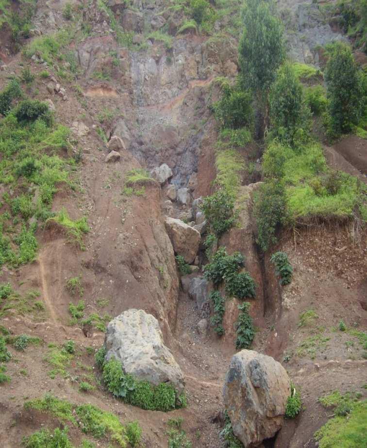
 Figure 11: Landslide after the")
13 II.2 Human factors Human factors can be related to the rapid urbanization Deforestation: natural soil protection removal Slope destabilisation by anarchique occupancy Figure 10: Triggering of mass mouvements (source: 3 tamis 2006) Figure 11: Landslide after the earthquake of 03/02/2008


14 Anarchic Occupancy Figure 12: View of la Roche Hotel from the lake Figure 14: Subsidence at La roche Hotel after the earthquake of 03/02/2008 Figure 13: La Roche Hotel on Google Earth image in 2009
15 III. DIACHRONIC ANALYSIS OF THE DEVELOPMENT OF BUKAVU & HAZARD MAPPING Figure 17: Evolution of people in the Bukavu city Between 1970 and 2008 the population increased more than four times within a constant area of about 60 km 2


16 NDVI Evolution between 1984 et 2000 Figure 18: Vegetal cover in 1984 Figure 19 Vegetal cover in 2000
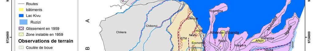
17 Figure 20: Bukavu between 1959 et 2009 Figure 21: Slope map of Bukavu


18 Figure 17: Bukavu between 1959 et 2009 Figure 18: Slope map of Bukavu
19 Images Comparaison: High Risk Areas Identification Figure 22: ITFM-Lycee Wima site on Corona image 1967 Figure 23: ITFM Lycee Wima site on Google Earth image 2009


20 Images Comparaison: High Risk Areas Identification Figure 22: ITFM-Lycee Wima site on Corona image 1967 Figure 23: ITFM Lycee Wima site on Google Earth image 2009
21 Images Comparaison: High Risk Areas Identification 100 m width of sediments accumulation in 35 years Figure 21: SNCC site on aerial photography Figure 22: SNCC site on Google Earth image 2009
22 Images Comparaison: High Risk Areas Identification 100 m width of sediments accumulation in 35 years Figure 24: SNCC site on aerial photography Figure 25: SNCC site on Google Earth image 2009


23 Images Comparaison: High Risk Areas Identification Subsidence at Bushushu after the earth quake of 23 rd Oct Subsidence at Birava after the earth quake of 8 th Feb m width of sediments accumulation in 35 years Figure 24:SNCC site on aerial photography Figure 25: SNCC site on Google Earth image 2009
24 Interweaving of different factors: Water collector broken, earthquake, ground conditions Road level Road s paving stone 10 m Figure 27: Landslide 1 day after event (12/8/1997) Nyamuhinga River Landslip & subsidence Figure 26: Landslide on Ikonos 2001 Figure 28: Landslide 1 week after event (18/8/1997)


25 Interweaving of different factors: Water collector broken, earthquake, ground conditions Road level Road s paving stone 10 m Figure 23: Landslide 1 day after event (12/8/1997) Nyamuhinga River Landslip & subsidence Figure 26: Landslide on Ikonos 2001 Figure 28: Landslide 1 week after event (18/8/1997)


26 Result: Map of vulnerability of the Bukavu city


27 Stages of Natural Hazards Management in Bukavu Risk= Hazard X Vulnerability Short Term (Remedial measures): Response after an event Evacuation Soil stabilization: bag of sand, gabion walls Surface water drains


28 Medium Term: preparation and prevention Evacuation plans Systematic drainage Soil stabilization with erosion control plants Gaps ventilated houses in flooding zones (suggestion) Vulnerability mapping Sensitization Drainage and slope stabilization in Bukavu Long Term: Prevention and Management Extend the City according to the demographic growth Encouraging Research in Natural Hazard Management Gaps ventilated house in Belgium (Sadiki, 2009)
29 Approach for a good management of natural hazards in Bukavu Pre-Assessment Alerts, Response Management Communication Assessment Evaluation Tolerability & Acceptability Figure 26: Risk Governance Framework (Sébatient Brunet, 2009)
30 IV. CONCLUSION & PERSPECTIVES Interweaving of different factors Urban plan GIS and remote sensing: an essential tool in urban planning and land use Detailed study for each type of geomorphologic hazard To extend the city of Bukavu


31 Thank you for your attention
Debris flow: categories, characteristics, hazard assessment, mitigation measures. Hariklia D. SKILODIMOU, George D. BATHRELLOS
 Debris flow: categories, characteristics, hazard assessment, mitigation measures Hariklia D. SKILODIMOU, George D. BATHRELLOS Natural hazards: physical phenomena, active in geological time capable of producing
Need of Proper Development in Hilly Urban Areas to Avoid
 Need of Proper Development in Hilly Urban Areas to Avoid Landslide Hazard Dr. Arvind Phukan, P.E. Cosultant/Former Professor of Civil Engineering University of Alaska, Anchorage, USA RI District Governor
Was the February 2008 Bukavu seismic sequence associated with magma intrusion?
 Was the February 2008 Bukavu seismic sequence associated with magma intrusion? N. d Oreye, C. Lucas National Museum of Natural History, Luxembourg nicolas.doreye@ecgs.lu P. Gonzalez, J. Fernández Univ.
International Symposium on Natural Disaster Mitigation. Local vulnerability assessment of landslides and debris flows
 International Symposium on Natural Disaster Mitigation of landslides and debris flows Lessons learnt from Cam Pha town and Van Don district, Quang Ninh province, Vietnam Nguyen Quoc Phi Faculty of Environment
INTRODUCTION. Climate
 INTRODUCTION Climate Landslides are serious natural disasters in many parts of the world. Since the past 30 years, rainfall triggered landslides and debris flows had been one of the natural disasters of
2013 Esri Europe, Middle East and Africa User Conference October 23-25, 2013 Munich, Germany
 2013 Esri Europe, Middle East and Africa User Conference October 23-25, 2013 Munich, Germany Environmental and Disaster Management System in the Valles Altos Region in Carabobo / NW-Venezuela Prof.Dr.habil.Barbara
The relationship between drainage density and soil erosion rate: a study of five watersheds in Ardebil Province, Iran
 River Basin Management VIII 129 The relationship between drainage density and soil erosion rate: a study of five watersheds in Ardebil Province, Iran A. Moeini 1, N. K. Zarandi 1, E. Pazira 1 & Y. Badiollahi
Geo-hazard Potential Mapping Using GIS and Artificial Intelligence
 Geo-hazard Potential Mapping Using GIS and Artificial Intelligence Theoretical Background and Uses Case from Namibia Andreas Knobloch 1, Dr Andreas Barth 1, Ellen Dickmayer 1, Israel Hasheela 2, Andreas
Landslide Susceptibility Model of Tualatin Mountains, Portland Oregon. By Tim Cassese and Colby Lawrence December 10, 2015
 Landslide Susceptibility Model of Tualatin Mountains, Portland Oregon By Tim Cassese and Colby Lawrence December 10, 2015 Landslide Closes Highway 30 at St. John's Bridge Introduction: Study Area: Tualatin
Gully erosion and associated risks in the Tutova basin Moldavian Plateau
 Landform Analysis, Vol. 17: 193 197 (2011) Gully erosion and associated risks in the Tutova basin Moldavian Plateau University Alexandru Ioan Cuza of Iasi, Department of Geography, Romania, e-mail: catiul@yahoo.com
CAPE Unit 1 Module 2 & 3. Topic Specific Objectives Content Explain the main concepts, flows and processes associated with coastal environments
 # Week(s) Wks 1-3 CAPE Unit 1 Module 2 & 3 Topic Specific Objectives Content Explain the main concepts, flows and processes associated with coastal environments Wave formation, structure, types Textbook
A Roundup of Recent Debris Flow Events in Taiwan
 2015 International Workshop on Typhoon and Flood APEC Experience Sharing on Hazardous Weather Events and Risk Management A Roundup of Recent Debris Flow Events in Taiwan Hsiao-Yuan(Samuel) Yin Ph.D. sammya@mail.swcb.gov.tw
LANDSLIDE SUSCEPTIBILITY MAPPING USING INFO VALUE METHOD BASED ON GIS
 LANDSLIDE SUSCEPTIBILITY MAPPING USING INFO VALUE METHOD BASED ON GIS ABSTRACT 1 Sonia Sharma, 2 Mitali Gupta and 3 Robin Mahajan 1,2,3 Assistant Professor, AP Goyal Shimla University Email: sonia23790@gmail.com
International Journal of Modern Trends in Engineering and Research e-issn No.: , Date: April, 2016
 International Journal of Modern Trends in Engineering and Research www.ijmter.com e-issn No.:2349-9745, Date: 28-30 April, 2016 Landslide Hazard Management Maps for Settlements in Yelwandi River Basin,
ACADEMIC YEAR New A level, first year, Linear
 ACADEMIC YEAR 2016-2017 Tutor s Name: Jerry Evans Subject: GEOGRAPHY New A level, first year, Linear Week/ Exam Module Topic Activities Homework Reports/ Autumn Half 1 Week 1 (7 th 9 th Sept) Physical
8 Current Issues and Research on Sediment Movement in the River Catchments of Japan
 8 Current Issues and Research on Sediment Movement in the River Catchments of Japan YUTAKA ICHIKAWA INTRODUCTION Prediction of sediment movement is one of the challenging tasks in water-related research.
Term Knowledge Using and applying Grade Criteria Autumn 1 Assessment window October Natural hazards pose major risks to people and property.
 Assessment Schedule Year 9 2015/6 Term Knowledge Using and applying Grade Criteria Autumn 1 Assessment window October 2015 3.1.1.2 Tectonic Natural hazards pose major risks to people and property. Definition
Stewards Pooi Kei College TEACHING SCHEDULE ( ) Form: S4 Subject : Geography No. of periods per cycle: 9 Teacher: Mr. Eric Chau Year/Month
 Form: S4 Subject : Geography No. of periods per cycle: 9 Teacher: Mr. Eric Chau Year/Month") Form: S4 Subject : Geography No. of periods per cycle: 9 Teacher: Mr. Eric Chau Year/Month 2009 September October November Topics / Subjects to be covered skills (if any) Remarks Cycle 1 What is tropical
Form: S4 Subject : Geography No. of periods per cycle: 9 Teacher: Mr. Eric Chau Year/Month 2009 September October November Topics / Subjects to be covered skills (if any) Remarks Cycle 1 What is tropical
Natural hazards in Glenorchy Summary Report May 2010
 Natural hazards in Glenorchy Summary Report May 2010 Contents Glenorchy s hazardscape Environment setting Flood hazard Earthquakes and seismic hazards Hazards Mass movement Summary Glossary Introduction
This table connects the content provided by Education Perfect to the NSW Syllabus.
 Education Perfect Geography provides teachers with a wide range of quality, engaging and innovative content to drive positive student learning outcomes. Designed by teachers and written by our in-house
WATERCOURSE HARNESSING BANK EROSION AND CONSOLIDATION
 GUVERNUL MINISTERUL POSDRU MUNCII, FAMILIEI ŞI WATERCOURSE HARNESSING BANK EROSION AND CONSOLIDATION PhD. student: ALUPOAE Daniel Gheorghe Asachi Technical University of Iasi, Faculty of Civil Engineering
Georeferencing and Satellite Image Support: Lessons learned, Challenges and Opportunities
 Georeferencing and Satellite Image Support: Lessons learned, Challenges and Opportunities Shirish Ravan shirish.ravan@unoosa.org UN-SPIDER United Nations Office for Outer Space Affairs (UNOOSA) UN-SPIDER
Interpretive Map Series 24
 Oregon Department of Geology and Mineral Industries Interpretive Map Series 24 Geologic Hazards, and Hazard Maps, and Future Damage Estimates for Six Counties in the Mid/Southern Willamette Valley Including
Physical Geography: Patterns, Processes, and Interactions, Grade 11, University/College Expectations
 Geographic Foundations: Space and Systems SSV.01 explain major theories of the origin and internal structure of the earth; Page 1 SSV.02 demonstrate an understanding of the principal features of the earth
Integrated and Multi-Hazard Disaster Management
 GeoSmart Asia 2016: GI for Disaster Preparedness and Risk Reduction Bandung, Indonesia 12 October 2016 Integrated and Multi-Hazard Disaster Management Lim Choun Sian & Nurfashareena Muhamad Centre for
Natural Terrain Risk Management in Hong Kong
 Natural Terrain Risk Management in Hong Kong Nick Koor Senior Lecturer in Engineering Geology School of Earth and Environmental Sciences Slope failures in Hong Kong Man-made Slope Failure - 300 landslides
6. What is the absolute location (latitude and longitude) and relative location of your home town or the town in which you attend school?
 and relative location of your home town or the town in which you attend school?") Social Studies 10 Chapter 1 Worksheet Directions: Be sure to complete reading the chapter before you attempt these questions. Be aware that the Chapter Test will cover everything you read in the chapter,
Social Studies 10 Chapter 1 Worksheet Directions: Be sure to complete reading the chapter before you attempt these questions. Be aware that the Chapter Test will cover everything you read in the chapter,
Using Weather and Climate Information for Landslide Prevention and Mitigation
 Using Weather and Climate Information for Landslide Prevention and Mitigation Professor Roy C. Sidle Disaster Prevention Research Institute Kyoto University, Japan International Workshop on Climate and
NORTH VISTA SECONDARY SCHOOL HUMANITIES DEPARTMENT SECONDARY 3 EXPRESS HUMANITIES (GEOGRAPHY) 2272/02 CONTENT OUTLINE Term 1
 2272/02 CONTENT OUTLINE Term 1") NORTH VISTA SECONDARY SCHOOL HUMANITIES DEPARTMENT SECONDARY 3 EXPRESS HUMANITIES (GEOGRAPHY) 2272/02 CONTENT OUTLINE 2019 Term 1 Week Learning Outcomes Skills to be covered Assignment Test Project 1-2
NORTH VISTA SECONDARY SCHOOL HUMANITIES DEPARTMENT SECONDARY 3 EXPRESS HUMANITIES (GEOGRAPHY) 2272/02 CONTENT OUTLINE 2019 Term 1 Week Learning Outcomes Skills to be covered Assignment Test Project 1-2
3l NATURAL HAZARDS AND UNSTABLE GROUND
 Page 1 of Section 3l 3l NATURAL HAZARDS AND UNSTABLE GROUND 3l.1 Introduction A natural hazard is the result of natural processes that form, shape and change the environment and interact or potentially
DROUGHT RISK EVALUATION USING REMOTE SENSING AND GIS : A CASE STUDY IN LOP BURI PROVINCE
 DROUGHT RISK EVALUATION USING REMOTE SENSING AND GIS : A CASE STUDY IN LOP BURI PROVINCE K. Prathumchai, Kiyoshi Honda, Kaew Nualchawee Asian Centre for Research on Remote Sensing STAR Program, Asian Institute
CLIMATE RESILIENT ALTITUDINAL GRADIENTS (CRAGs)
") CLIMATE RESILIENT ALTITUDINAL GRADIENTS (CRAGs) BUILDING CLIMATE CHANGE RESILIENCE IN THE KIVU- RUSIZI WATERSHEDS Great Lake Conference Entebbe 2017 Chris Magero WHAT ARE CRAGs? Climate-Resilient Altitudinal
CLIMATE RESILIENT ALTITUDINAL GRADIENTS (CRAGs) BUILDING CLIMATE CHANGE RESILIENCE IN THE KIVU- RUSIZI WATERSHEDS Great Lake Conference Entebbe 2017 Chris Magero WHAT ARE CRAGs? Climate-Resilient Altitudinal
Earthquake Emergency Preparedness in Central-Hungary
 UN-SPIDER Fourth United Nations International UN-SPIDER Bonn Workshop on Disaster Management and Space Technology: The 4C Challenge:Communication Coordination Cooperation Capacity Development Bonn, Germany,
Mapping Water Resources and Reservoirs for Climate Resilience in Zambezi River Basin
 Mapping Water Resources and Reservoirs for Climate Resilience in Zambezi River Basin Corné van der Sande, NEO BV Senior Advisor Earth Observation Services for Monitoring Drought and Water Resources in
Landslide analysis to estimate probability occurrence of earthquakes by software ArcGIS in central of Iran
 Research Journal of Recent Sciences ISSN 2277-2502 Res.J.Recent Sci. Landslide analysis to estimate probability occurrence of earthquakes by software ArcGIS in central of Iran Abstract Hamid Reza Samadi
Geography Class XI Fundamentals of Physical Geography Section A Total Periods : 140 Total Marks : 70. Periods Topic Subject Matter Geographical Skills
 Geography Class XI Fundamentals of Physical Geography Section A Total Periods : 140 Total Marks : 70 Sr. No. 01 Periods Topic Subject Matter Geographical Skills Nature and Scope Definition, nature, i)
Response on Interactive comment by Anonymous Referee #1
 Response on Interactive comment by Anonymous Referee #1 Sajid Ali First, we would like to thank you for evaluation and highlighting the deficiencies in the manuscript. It is indeed valuable addition and
The sketch map of field investigations in Wenchuan earthquake hit region, Chengdu City.
 The sketch map of field investigations in Wenchuan earthquake hit region, Chengdu City. 1 Environmental and Geological Condition 1.1 Geomorphology BaiSha River Basin is located in Dujiangyan County, and
GIS Application in Landslide Hazard Analysis An Example from the Shihmen Reservoir Catchment Area in Northern Taiwan
 GIS Application in Landslide Hazard Analysis An Example from the Shihmen Reservoir Catchment Area in Northern Taiwan Chyi-Tyi Lee Institute of Applied Geology, National Central University, No.300, Jungda
RISK ASSESSMENT METHODOLOGIES FOR LANDSLIDES
 RISK ASSESSMENT METHODOLOGIES FOR LANDSLIDES Jean-Philippe MALET Olivier MAQUAIRE CNRS & CERG. Welcome to Paris! 1 Landslide RAMs Landslide RAM A method based on the use of available information to estimate
GENERAL. CHAPTER 1 BACKGROUND AND PURPOSE OF THE GUIDELINES Background of the Guidelines Purpose of the Guidelines...
 GENERAL CHAPTER 1 BACKGROUND AND PURPOSE OF THE GUIDELINES... 1 1.1 Background of the Guidelines... 1 1.2 Purpose of the Guidelines... 3 CHAPTER 2 APPLICATION OF THE GUIDELINES... 3 2.1 Potential Users
SLOPE PROCESSES, LANDSLIDES, AND SUBSIDENCE
 CHAPTER 9 SLOPE PROCESSES, LANDSLIDES, AND SUBSIDENCE La Conchita slide January 10, 2005 Triggered by heavy rainfall, reactivation along an older landslide surface (35,000 years ago, 6000 years ago, and
EIT-Japan Symposium 2011 on Human Security Engineering
 EIT-Japan Symposium 2011 on Human Security Engineering 2011 Disastrous Landslides at Khao Panom, Krabi, Thailand Suttisak Soralump Geotechnical Engineering Research and Development Center (GERD) Faculty
Surface Processes Focus on Mass Wasting (Chapter 10)
") Surface Processes Focus on Mass Wasting (Chapter 10) 1. What is the distinction between weathering, mass wasting, and erosion? 2. What is the controlling force in mass wasting? What force provides resistance?
Surface Processes Focus on Mass Wasting (Chapter 10) 1. What is the distinction between weathering, mass wasting, and erosion? 2. What is the controlling force in mass wasting? What force provides resistance?
Copernicus Overview. Major Emergency Management Conference Athlone 2017
 Copernicus Overview Major Emergency Management Conference Athlone 2017 Copernicus is a European programme implemented by the European Commission. The services address six thematic areas: land, marine,
Flash flood disaster in Bayangol district, Ulaanbaatar
 Flash flood disaster in Bayangol district, Ulaanbaatar Advanced Training Workshop on Reservoir Sedimentation Management 10-16 October 2007. IRTCES, Beijing China Janchivdorj.L, Institute of Geoecology,MAS
Abdolreza Ansari Amoli. Remote Sensing Department Iranian Space Agency
 Risk Assessment and Mapping Using Earth Observation Data In Iran Abdolreza Ansari Amoli Remote Sensing & GIS Expert Remote Sensing Department Iranian Space Agency Different Types of Disasters in Iran Epidemic
Study of Hydrometeorology in a Hard Rock Terrain, Kadirischist Belt Area, Anantapur District, Andhra Pradesh
 Open Journal of Geology, 2012, 2, 294-300 http://dx.doi.org/10.4236/ojg.2012.24028 Published Online October 2012 (http://www.scirp.org/journal/ojg) Study of Hydrometeorology in a Hard Rock Terrain, Kadirischist
Landslide Hazard Zonation Methods: A Critical Review
 International Journal of Civil Engineering Research. ISSN 2278-3652 Volume 5, Number 3 (2014), pp. 215-220 Research India Publications http://www.ripublication.com/ijcer.htm Landslide Hazard Zonation Methods:
OIKOS > landslide > mechanism >predisposing causes
 predisposing causes and trigger OIKOS > landslide > mechanism >predisposing causes Landslides are events that occur in space and time. As such, it is usually possible to identify both one or more landslide
Workshop on Drought and Extreme Temperatures: Preparedness and Management for Sustainable Agriculture, Forestry and Fishery
 Workshop on Drought and Extreme Temperatures: Preparedness and Management for Sustainable Agriculture, Forestry and Fishery 16-17 Feb.2009, Beijing, China Modeling Apple Tree Bud burst time and frost risk
LAND DEGRADATION IN THE CARIBBEAN: QUATERNARY GEOLOGICAL PROCESSES. RAFI AHMAD
 EXTENDED TASK FORCE MEETING OF PARTICIPATING AGENCIES AND LATIN AMERICAN COUNTRIES FOR ENHANCING SOUTH-SOUTH COOPERATION BETWEEN LAC-CARIBBEAN SIDS PARTNERSHIP INITIATIVE ON LAND DEGRADATION AND SUSTAINABLE
An analysis on the relationship between land subsidence and floods at the Kujukuri Plain in Chiba Prefecture, Japan
 doi:10.5194/piahs-372-163-2015 Author(s) 2015. CC Attribution 3.0 License. An analysis on the relationship between land subsidence and floods at the Kujukuri Plain in Chiba Prefecture, Japan Y. Ito 1,
LANDSLIDE HAZARDS. presented during the. TRAINING-WORKSHOP ON DISASTER RISK MANAGEMENT Rakdell Inn Virac, Catanduanes 03 July 2008
 LANDSLIDE HAZARDS presented during the TRAINING-WORKSHOP ON DISASTER RISK MANAGEMENT Rakdell Inn Virac, Catanduanes 03 July 2008 GEOLOGIC HAZARDS the probability of occurrence, within a specific period
b. Why is the area affected by each earthquake circular or nearly circular? Where is the epicenter of each quake located?
 Name: Skill Sheet 29-A Interpreting Geologic Hazard Maps Plate tectonics and the weather are often the cause of geologic hazards such as earthquakes, volcanic eruptions, and flooding. Geologic hazard events
Effects of climate change on landslide frequencies in landslide prone districts in Sri Lanka; Overview
 Effects of climate change on landslide frequencies in landslide prone districts in Sri Lanka; Overview T. D. Rathnaweera 1)., M. P. Palihawadana 2)., H. L. L. Rangana 3). and Dr. U. P. Nawagamuwa 4). Abstract
NATURAL HAZARDS PROFILE OF JAMAICA RAFI AHMAD
 NATURAL HAZARDS PROFILE OF JAMAICA RAFI AHMAD rafi.ahmad@uwimona.edu.jm UNIT FOR DISASTER STUDIES DEPARTMENT OF GEOGRAPHY AND GEOLOGY Tel. 1-876-927-2728/2129 Fax: 1-876-977-6029 THE UNIVERSITY OF THE
TABLE OF CONTENTS LIST OF TABLES. Page
 TABLE OF CONTENTS Page 11.0 EFFECTS OF THE ENVIRONMENT ON THE PROJECT... 11-1 11.1 Weather Conditions... 11-1 11.2 Flooding... 11-2 11.3 Forest Fires... 11-2 11.4 Permafrost and Subsidence Risk... 11-3
Landslide Susceptibility Mapping Using Logistic Regression in Garut District, West Java, Indonesia
 Landslide Susceptibility Mapping Using Logistic Regression in Garut District, West Java, Indonesia N. Lakmal Deshapriya 1, Udhi Catur Nugroho 2, Sesa Wiguna 3, Manzul Hazarika 1, Lal Samarakoon 1 1 Geoinformatics
2014 Summer Training Courses on Slope Land Disaster Reduction Hydrotech Research Institute, National Taiwan University, Taiwan August 04-15, 2014
 Final Project Report 2014 Summer Training Courses on Slope Land Disaster Reduction Hydrotech Research Institute, National Taiwan University, Taiwan August 04-15, 2014 Landslides in Mt. Umyeon Susceptibility
Uses of free satellite imagery for Disaster Risk Reduction (DRR)
") Centre of Applied Geoscience, Disaster Risk Reduction Research Group, School of Earth and Environmental Science, University of Portsmouth, UK Uses of free satellite imagery for Disaster Risk Reduction
Centre of Applied Geoscience, Disaster Risk Reduction Research Group, School of Earth and Environmental Science, University of Portsmouth, UK Uses of free satellite imagery for Disaster Risk Reduction
VULNERABILITY OF WATER SUPPLY TO NATURAL HAZARDS IN JAMAICA
 VULNERABILITY OF WATER SUPPLY TO NATURAL HAZARDS IN JAMAICA RAFI AHMAD rafi.ahmad@uwimona.edu.jm Unit for disaster studies, Department of Geography & Geology, The University of the West Indies, Mona Kingston
SOCIO-ECONOMIC IMPACTS OF FLOODING IN DIRE DAWA, ETHIOPIA
 SOCIO-ECONOMIC IMPACTS OF FLOODING IN DIRE DAWA, ETHIOPIA Alemu Yonas Tadesse * Supervisor: Prof. A.W. Jayawardena ** MEE08182 ABSTRACT Dire Dawa, the second largest city of Ethiopia, has been suffering
DISASTER HAZARDS IN BHUTAN By Tshewang Rinzin January Reducing Disaster Risks for a Safe and Happy Bhutan
 DISASTER HAZARDS IN BHUTAN By Tshewang Rinzin 26-27 January 2009 Reducing Disaster Risks for a Safe and Happy Bhutan Disaster Hazards in Bhutan Earthquakes Glacial Lake Outburst Flood (GLOF) Floods in
1.0 Introduction 1.1 Geographic Location 1.2 Topography 1.3 Climate and Rainfall 1.4 Geology and Hydrogeology 1.5 Water Availability 1.
 1.0 1.1 Geographic Location 1.2 Topography 1.3 Climate and Rainfall 1.4 Geology and Hydrogeology 1.5 Water Availability 1.6 Demography 1.0 1.1 Geographic Location St. Lucia forms part of an archipelago
Practical reliability approach to urban slope stability
 University of Wollongong Research Online Faculty of Engineering - Papers (Archive) Faculty of Engineering and Information Sciences 2011 Practical reliability approach to urban slope stability R. Chowdhury
Landslide Hazard Assessment Methodologies in Romania
 A Scientific Network for Earthquake, Landslide and Flood Hazard Prevention SciNet NatHazPrev Landslide Hazard Assessment Methodologies in Romania In the literature the terms of susceptibility and landslide
Disaster Risk Reduction and
 6 th ICRM Symposium 2015 Disaster Risk Reduction and 2015/04/23 Resilience in Taipei Outline Natural Disaster and Loss in Taiwan Climate Change and Geohazard Hazard Alert & App Monitoring & Modeling Land
Geologic Hazards. Montour County Multi-jurisdictional. General. Earthquake
 Geologic Hazards General s are very rare in Pennsylvania and have caused little damage with no reported injuries or causalities. s that do occur in Pennsylvania happen deep within the Earth s crust. This
Fukien Secondary School Monthly Vocabulary/Expression List for EMI Subjects Secondary Two. Subject: Geography
 Focus: General Specific : Section Two : Unit One 1 Landslide 2 Downslope movement 3 Rock 4 Soil 5 Gravity 6 Natural hazard 7 Rainwater 8 Friction 9 Hilly relief 10 Unstable 11 Season 12 Saturated 13 Construction
D DAVID PUBLISHING. Vulnerability to Landslides in the City of Sao Paulo. 1. Introduction. 2. Methodology
 Journal of Civil Engineering and Architecture 10 (2016) 1160-1167 doi: 10.17265/1934-7359/2016.10.007 D DAVID PUBLISHING Vulnerability to Landslides in the City of Sao Paulo Letícia Palazzi Perez 1, 2
Soil Erosion Calculation using Remote Sensing and GIS in Río Grande de Arecibo Watershed, Puerto Rico
 Soil Erosion Calculation using Remote Sensing and GIS in Río Grande de Arecibo Watershed, Puerto Rico Alejandra M. Rojas González Department of Civil Engineering University of Puerto Rico at Mayaguez.
Coastal Vulnerability Assessment in Semarang City, Indonesia Based on Sea Level Rise and Land Subsidence Scenarios
 Coastal Vulnerability Assessment in Semarang City, Indonesia Based on Sea Level Rise and Land Subsidence Scenarios I. M. Radjawane, D. Hartadi and W. R. Lusano Oceanography Research Division Fac. of Earth
Tampere - City planning, geology and climate change
 Tampere - City planning, geology and climate change 3 rd International BaltCICA Conference Petri Jokinen, City of Tampere 19 th January 2012 City of Tampere in BaltCICA: City of Tampere is located between
Geomorphology and Landslide Hazard Models
 Geomorphology and Landslide Hazard Models Steve Parry GeoRisk Solutions Key component of interpreting geomorphology and therefore hazard at a site is the use of API The purpose of this talk is not to try
ENVIRONMENTAL GEOSCIENCE UNIFORM SYLLABUS
 ENVIRONMENTAL GEOSCIENCE UNIFORM SYLLABUS The Association of Professional Engineers and Geoscientists of the Province of British Columbia Note: 1. This Syllabus May Be Subject To Change 2. These Courses
Introduction to Environmental Geology, 5e Case History: Indonesian Tsunami Indonesian Tsunami (2) Introduction Historic Tsunamis
 Introduction Historic Tsunamis") 1 2 3 4 5 6 7 8 9 Introduction to Environmental Geology, 5e Chapter 7 Tsunami Case History: Indonesian Tsunami December 26, 2004, within a few hours, close to 250,000 people were killed With no warning
1 2 3 4 5 6 7 8 9 Introduction to Environmental Geology, 5e Chapter 7 Tsunami Case History: Indonesian Tsunami December 26, 2004, within a few hours, close to 250,000 people were killed With no warning
9. GEOLOGY, SOILS, AND MINERALS
 June 28, 2018 Page 9-1 9. GEOLOGY, SOILS, AND MINERALS This EIR chapter describes the existing geological, soil, and mineral conditions in the planning area. The chapter includes the regulatory framework
5.2 IDENTIFICATION OF HAZARDS OF CONCERN
 5.2 IDENTIFICATION OF HAZARDS OF CONCERN To provide a strong foundation for mitigation actions considered in Sections 6 and 9, County focused on considering a full range of s that could impact area, and
Preparing Landslide Inventory Maps using Virtual Globes
 Introduction: A landslide is the movement of a mass of rock, debris, or earth down a slope, under the influence of gravity. Landslides can be caused by different phenomena, including intense or prolonged
Geostatistical Analysis of Rainfall Temperature and Evaporation Data of Owerri for Ten Years
 Atmospheric and Climate Sciences, 2012, 2, 196-205 http://dx.doi.org/10.4236/acs.2012.22020 Published Online April 2012 (http://www.scirp.org/journal/acs) Geostatistical Analysis of Rainfall Temperature
RISK ASSESSMENT OF HYDROCARBON PIPELINES FACING NATURAL HAZARDS
 UN Environment / UN OCHA Joint Unit Prepare. Respond. Protect OECD Working Group on Chemical Accidents Federal Ministry for the Environment, Nature Conservation and Nuclear Safety Ministry for Rural Development,
Disaster Risk Assessment: Opportunities for GIS and data management with Open DRI
 Disaster Risk Assessment: Opportunities for GIS and data management with Open DRI Jacob Opadeyi Department of Geomatics Engineering and Land Management, The University of the West Indies, St. Augustine,
9/13/2011 CHAPTER 9 AND SUBSIDENCE. Case History: La Conchita Landslide. Introduction
 CHAPTER 9 SLOPE PROCESSES, LANDSLIDES, AND SUBSIDENCE Case History: La Conchita Landslide La Conchita: small coastal community 80 km (50 mi) northwest of Los Angeles Landslide occurred on January 10, 2005
INTERNATIONAL JOURNAL OF GEOMATICS AND GEOSCIENCES Volume 1, No 1, 2010
 An Integrated Approach with GIS and Remote Sensing Technique for Landslide Hazard Zonation S.Evany Nithya 1 P. Rajesh Prasanna 2 1. Lecturer, 2. Assistant Professor Department of Civil Engineering, Anna
D.R. Congo. Vikandy S. Mambo Université Officielle de Ruwenzori, Butembo, North-Kivu, Eastern Congo
 Geothermal Exploration in D.R. Congo Vikandy S. Mambo Université Officielle de Ruwenzori, Butembo, North-Kivu, Eastern Congo 1 Geochemical Study of Thermal Springs in Eastern D.R. Congo Mambo Vikandy S.,
MODELLING FROST RISK IN APPLE TREE, IRAN. Mohammad Rahimi
 WMO Regional Seminar on strategic Capacity Development of National Meteorological and Hydrological Services in RA II (Opportunity and Challenges in 21th century) Tashkent, Uzbekistan, 3-4 December 2008
Analysis of Historical Pattern of Rainfall in the Western Region of Bangladesh
 24 25 April 214, Asian University for Women, Bangladesh Analysis of Historical Pattern of Rainfall in the Western Region of Bangladesh Md. Tanvir Alam 1*, Tanni Sarker 2 1,2 Department of Civil Engineering,
Module 2 Educator s Guide Investigation 2
 Module 2 Educator s Guide Investigation 2 How does remote sensing help us to observe human activities on Earth? Investigation Overview Landscapes that are influenced by human activities are found nearly
mountain rivers fixed channel boundaries (bedrock banks and bed) high transport capacity low storage input output
 high transport capacity low storage input output") mountain rivers fixed channel boundaries (bedrock banks and bed) high transport capacity low storage input output strong interaction between streams & hillslopes Sediment Budgets for Mountain Rivers Little
mountain rivers fixed channel boundaries (bedrock banks and bed) high transport capacity low storage input output strong interaction between streams & hillslopes Sediment Budgets for Mountain Rivers Little
Sediment Deposition LET THE RIVER RUN T E A C H E R. Activity Overview. Activity at a Glance. Time Required. Level of Complexity.
 Activity at a Glance Grade: 6 9 Subject: Science Category: Physical Science, Earth Science Topic: Deposition, River Systems Time Required Two 45-minute periods Level of Complexity Medium Materials* TI-73
Use of Geospatial data for disaster managements
 Use of Geospatial data for disaster managements Source: http://alertsystemsgroup.com Instructor : Professor Dr. Yuji Murayama Teaching Assistant : Manjula Ranagalage What is GIS? A powerful set of tools
GEOTECHNICAL ENGINEERING INVESTIGATION HANDBOOK Second Edition
 GEOTECHNICAL ENGINEERING INVESTIGATION HANDBOOK Second Edition Roy E. Hunt Taylor & Francis Taylor & Francis Croup Boca Raton London New York Singapore A CRC title, part of the Taylor & Francis imprint,
2. PHYSICAL SETTING FINAL GROUNDWATER MANAGEMENT PLAN. 2.1 Topography. 2.2 Climate
 FINAL GROUNDWATER MANAGEMENT PLAN 2. PHYSICAL SETTING Lassen County is a topographically diverse area at the confluence of the Cascade Range, Modoc Plateau, Sierra Nevada and Basin and Range geologic provinces.
THE TRANSECTS. Oldenburger,F.H.F. & Norde,R.* Online publication 2009 Correspondence author.
 THE TRANSECTS By Oldenburger,F.H.F. & Norde,R.* Online publication 2009 Correspondence author. Email r.norde@kpnplanet.nl Apart from the floristic inventarisation, the syn-ecological and syn-systematic
GG101 Lecture 22: Mass Wasting. Soil, debris, sediment, and broken rock is called regolith.
 GG101 Lecture 22: Mass Wasting Mass Wasting is the movement of rock and soil down a slope due to the force of gravity. Soil, debris, sediment, and broken rock is called regolith. Mass wasting creates broad
Downloaded from Downloaded from
 IV SEMESTER BACK-PAPER EXAMINATION-2004 Q. [1] [a] Describe internal structure of the earth with a neat sketch. Write down the major land forms and their characteristics on the earth surface. [8] [b] What
USING 3D GIS TO ASSESS ENVIRONMENTAL FLOOD HAZARDS IN MINA
 King Fahd University of Petroleum & Minerals College of Environmental Design Geographical Information system USING 3D GIS TO ASSESS ENVIRONMENTAL FLOOD HAZARDS IN MINA Prepared by : Ali AL-Zahrani OUTLINE
Mutah university faculty of Social Sciences The Study plan of the department of Geography 2006/2007
 Mutah university faculty of Social Sciences The Study plan of the department of Geography 2006/2007 Requirements university compulsory 22 Credit hours Course No Credit hours Prerequisite Requirements Faculty
Geography GCSE. Year 9 Term and Topic Unit Content Homework Opportunities
 Geography GCSE Year 9 Term and Topic Unit Content Homework Opportunities Autumn Term 1: Geographical Skills Autumn Term 2: Tectonic Hazards Spring Term 1: Ecosystems Rainforest Students are required to