The relationship between drainage density and soil erosion rate: a study of five watersheds in Ardebil Province, Iran
|
|
|
- Wendy Lester
- 5 years ago
- Views:
Transcription
1 River Basin Management VIII 129 The relationship between drainage density and soil erosion rate: a study of five watersheds in Ardebil Province, Iran A. Moeini 1, N. K. Zarandi 1, E. Pazira 1 & Y. Badiollahi 2 1 Department of Watershed Management, College of Agriculture and Natural Resources, Science and Research Branch, Islamic Azad University, Iran 2 University College of Nabie Akram (UCNA), Iran Abstract Drainage density is one of the parameters that can be considered as an indicator of erosion rate. This study analysed the relationship between drainage density and soil erosion in five watersheds in Iran. The drainage density was measured using satellite images, aerial photos, and topographic maps by Geographic Information Systems (GIS) technologies. MPSIAC model was employed in a GIS environment to create soil erosion maps using data from meteorological stations, soil surveys, topographic maps, satellite images and results of other relevant studies. Then the correlation between drainage density and erosion rate was measured. The mean soil loss rate in the study areas were 1 to 6.43 t.h -1.y -1 and drainage density values varied 1.44 to 5.43 Km Km -1.The results indicate that the relationship between these two factors improved when the types of sheet erosion, mechanical erosion and mass erosion was ignored because these types of erosion were not mainly influenced by the power of runoff. There was a high correlation between drainage density and erosion in most of the watersheds. Finally a significant relationship was seen between drainage density and erosion in all watersheds. Based on the results obtained, the present method for distinguishing soil erosion was effective and can be used for operational erosion monitoring in other watersheds with the same climate characteristics in Iran. Keywords: surface erosion, drainage density, MPSIAC model, GIS. doi: /rm150121
2 130 River Basin Management VIII 1 Introduction Soil erosion by water plays an important role in the process of land degradation and is linked to a number of environmental and socioeconomic problems worldwide. The effects of water erosion can be observed both on-site and offsite. On-site impacts are important in soils for agriculture, which leads to greater applying fertilizers and later may cause the abandonment of agriculture. The offsite impacts creates different problems associated with the deposition and consolidation of sediments in reservoirs, navigation canals, storm water pipes systems, retention ponds, floodplains, etc. [1]. Factors affecting water erosion and sediment production in the basin include: Types of geological formations, weather and climate, soil, topography, vegetation and land use. One of the parameters that can be regarded as an indicator of erosion is drainage density, which is the total length of streams per unit area of the watershed and depends on the factors such as lithology, permeability, vegetation. Drainage density varies in different tissues and depends on the soil type [2]. A study on erosion in geomorphology facies done by Ahmadi et al. [3] stated the relationship between the density of drainage and erosion. Spatial analysis of drainage network was performed by using GIS by Mishra [4]. During the study, priority areas for erosion control [5] and surface erosion and drainage basin development [6] were investigated. The effect of type of drainage on reduction and storage of surface runoff and capacity of the soil was reviewed by Irwin and Whiteley [7]. The aim of this study was to examine the relationship between drainage density and intensity of erosion in the different watersheds of Ardebil province. 2 Materials and methods 2.1 Sites description A. Narghashlaghy watershed with the area of 4, hectares is in the northern city of Ardebil and with coordinates, 47, 59, 8 to 48, 6, 10 east longitude and 39, 12, 22 to 39, 16, 7 the north latitude. B. Bargchay watershed of MeshkinShahr with the area of 4,541.7 hectares, located in the north of Razi, one city of the Ardabil province, in geographic coordinates 48, 0, 37 to 48, 9, 48 east longitude and 38, 39, 56 to 38, 46, 16 the north latitude. C. Siahpoush watershed with the area of 10,103.4 hectares is one of the southern cities of Ardebil located in geographic coordinates 48, 6, 35 to 48, 16, 46 east longitude and 37, 46, 8 to 37, 54, 0 north latitude. D. Saghezchichay watershed with the area of 6,607 hectares with coordinates 47, 54, 7 to 48, 42, 44 east longitude and 38, 9, 11 to 38, 16, and 53 north latitude is located in the eastern of Ardabil. E. Alucheh-Fuladlu watershed with the area of 5,466.1 hectares is located in the south east of Ardebil with coordinates 48, 7, 21 to 48, 25, 56 east longitude and 38, 58, 6 to 38, 6, 2 north latitude.
3 River Basin Management VIII Methods The drainage density was measured using satellite images, aerial photos, and topographic maps by Geographic Information Systems (GIS) technologies. The MPSIAC model was employed in a GIS environment to create soil erosion maps using data from meteorological stations, soil surveys, topographic maps, satellite images and results of other relevant studies. Then the correlation between drainage density and erosion rate was measured. The following equation was used to calculate the drainage density. L D = (1) A where ΣL is the total length of the hydrographic network (km) and A is the hydrographic basin area (km 2 ). The MPSIAC model was used for erosion estimation. This model was created to estimate the soil erosion according to nine factors consisting of, geological characteristics, soil, climate, runoff, topography, vegetation cover, land use and present soil erosion (PSIAC, 1968). Johnson and Gembhart (1982) improved the original model to have a more accurate estimate of the sedimentation (eqn 2). QS = 25.3*e^.036*R (2) where QS is sedimentation (t/km 2 /year), R is sedimentation rate and e = Table 1: MPSIAC nine factors in erosion types of different studied watersheds. No Description X1: stone sensitive point X2: erodibility factor in USLE X3: precipitation intensity with 2 year interval return X4: annual runoff depth (mm), Qp: annual specific discharge X5: average watershed slope (%) X6: bare soil (%) X7: canopy cover (%) X8: points summation in BLM model X9: point of Gully erosion in BLM model Relationship Y1 = x1 Y2 = x2 Y3 = 0.2 x3 Y4 = 0.2(0.006 R+ 10QP) Y5 = 0.33 x5 Y6 = 0.2 x6 Y7 = x7 Y8 = 0.25 x8 Y9 = 1.67 x9 3 Results By calculating drainage density and erosion rate in studied watersheds, the following information was obtained:
4 132 River Basin Management VIII Table 2: Relationship between drainage density and erosion in Narghashlaghi Erosion types S1 R1 S2 R1 W1 S2 R2 W1 S2 R2 W2 S3 R3 W2 S3 R3 W3 M1 Area (km 2 ) Drainage density (km/km 2 ) Erosion (TON/km 2 /Y) Table 3: Relationship between drainage density and erosion in Bargchay Erosion types S3 M2 S4 R2 S2 R1 S3 R1 S3 M1 Area (km 2 ) Drainage density (km/km 2 ) Erosion (TON/km 2 /Y) Table 4: Relationship between drainage density and erosion in Siahpoush Erosion types S3 R3 S2 S3 R3 LS1 S2 R3 LS2 S3 R2 W3 LS2 S3 R3 W2 LS2 Area (km 2 ) Drainage density (km/km 2 ) Erosion (TON/km 2 /Y) Table 5: Relationship between drainage density and erosion in Saghezchichay Erosion types S1 R1 S2 R2 W1 S2 R1 W1 M1 S2 R2 W2 M2 S3 R3 S3 R2 W1 M2 Area (km 2 ) Drainage density (km/km 2 ) Erosion (TON/km 2 /Y)


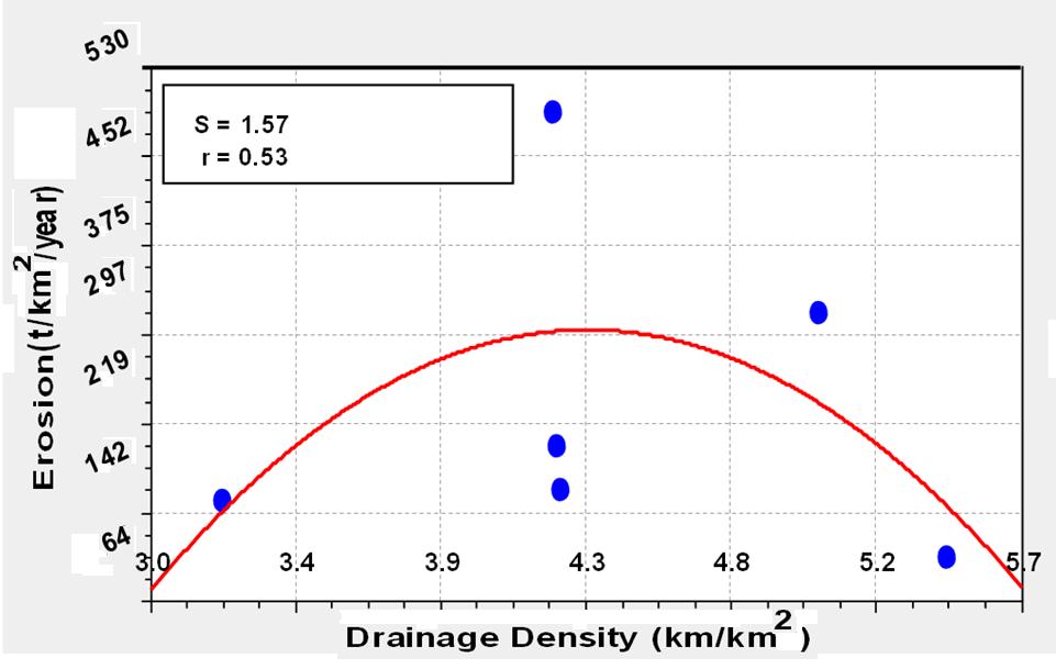
5 River Basin Management VIII 133 Table 6: Relationship between drainage density and erosion in Alucheh- Fuladlu Erosion types Area (km 2 ) Drainage density Erosion (km/km 2 ) (TON/km 2 /Y) S S1 R S2 R1 M S2 R2 Gu S3 R2 W S3 R3 W2 M (S: surface, R: rill, W: Channel, Gu: gully, M: mechanical, LS: land slide (mass movement) erosion and numbers present erosion intensity). First, by the statistical analysis using SPSS software and charting the drainage density and erosion, it was observed that there is not a significant linear relationship between the drainage density and erosion. Figure 1: Relation between drainage density and erosion in Figure 2: Relation between drainage density and erosion in Bargchay


6 134 River Basin Management VIII Figure 3: Relation between drainage density and erosion in Siahpoush Figure 4: Relation between drainage density and erosion in Saghezchichay Figure 5: Relation between drainage density and erosion in Alucheh-Fuladlu
 in the Siahpoush watershed, weak surface erosion in the Saghezchichay watershed, poor surface")

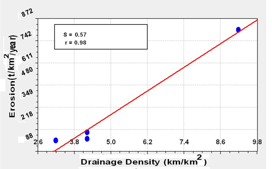
7 River Basin Management VIII 135 Since there is no relation between drainage density and mechanical, mass and surface erosion, then surface erosion in the Narghashlaghi watershed, surface erosion and weak mechanical in the Bargchay watershed, medium surface erosion and land slide (mass) in the Siahpoush watershed, weak surface erosion in the Saghezchichay watershed, poor surface erosion in the Alucheh-Fuladlu watershed, have not been considered. With statistical analysis using SPSS software and charting drainage density and erosion, it was observed that the linear correlation between the drainage density and erosion is created. Figure 6: Relation between drainage density and erosion in Narghashlaghi Figure 7: Relation between drainage density and erosion in Bargchay


8 136 River Basin Management VIII Figure 8: Relation between drainage density and erosion in Siahpoush Figure 9: Relation between drainage density and erosion in Saghezchichay Figure 10: Relation between drainage density and erosion in Alucheh-Fuladlu

9 River Basin Management VIII 137 With statistical analysis using SPSS software and charting drainage density and erosion in all watersheds, it was observed that there is a linear correlation between the drainage density and erosion. Figure 11: Relation between drainage density and erosion in all mentioned 4 Conclusion Drainage density is an important factor that affects erosion process. Therefore, its management can cause erosion control in the region. Drainage density depends on soil type and amount of flow through the channel, that is compatible with results of Germanoski et al. [2] who compared the drainage density in areas with different textures (shale, slate) in East Pennsylvania. Drainage density has not any role in the surface, mechanical and mass erosion, because these types of erosion was not be affected by stream. Finally, there is a significant correlation between the drainage density and erosion that corresponds with Ahmadi et al. [3] results, which examines the relationship in Sarvelayats On the other hand; we can estimate the rate of erosion with using of drainage density. Reference [1] Pedro, A. B., Gerardo A. R., Erik D. Z. & Hernán R. Stenta. Simulation of erosion-deposition processes at basin scale by a physically-based mathematical model. International Journal of Sediment Research, 25, [2] Germanoski, D., Hardy, S. & Wilson, J., Comparison of Drainage Densities in Carbonate vs Shale/Slate, Eastern Pennsylvania, Proc. Awra Spring Speciality Conference New Orleans, [3] Ahmadi, H., A, Kelarestaghi, & N. Mashhadi, Survey of erosion in geomorphological facies and its relationship with drainage density in Sarvelayat Iranian Journal of Natural Resources.Vol 60, No 4, [4] Mishra, S., Spatial Analysis Of Drainage Network For Ground Water Exploration In River Basin Using GIS And Remote Sensing Techniques: a
10 138 River Basin Management VIII Case Study Of Tons River In Allahabad, India Journal of Environmental Research And Development, Vol. 7, No. 3, [5] Zhang, X., Wu, B., Ling, F., Zeng, Y., Yan, N. & Youan, C., Identification of priority areas for controlling soil erosion. Catena 83, [6] Shyamal, D. & Suvendu, R., Determination of erosion surfaces and stages of evolution of Sangr drainage basin in Giridih district, Jharkhand, India. International Journal of Geomatic and Geoscience, Volume 3, No 1. pp , [7] Ross W. Irwin & Hugh R. Whiteley. Effects of Land Drainage on Stream Flow. Canadian Water Resources Journal, Vol. 8, No. 2, 2013.
Sediment- yield estimation, by M-PSIAC method in a GIS environment, case study:jonaghn river sub basin(karun basin)
") Sediment- yield estimation, by M-PSIAC method in a GIS environment, case study:jonaghn river sub basin(karun basin) Yavari-shahla *,Khdabakhsh-Saeed,Mohseni-Hasan, Rezai- Khalil Corresponding author: a
Sediment- yield estimation, by M-PSIAC method in a GIS environment, case study:jonaghn river sub basin(karun basin) Yavari-shahla *,Khdabakhsh-Saeed,Mohseni-Hasan, Rezai- Khalil Corresponding author: a
The Sensitivity Analysis and Efficiency of FSM and MPSIAC Models for Estimating Sediment Load
 The Sensitivity Analysis and Efficiency of FSM and MPSIAC Models for Estimating Sediment Load Ali Gholami, and Pezhman Mesri Alamdari Abstract This study was conducted in Nahand watershed, two models of
Surface Processes Focus on Mass Wasting (Chapter 10)
") Surface Processes Focus on Mass Wasting (Chapter 10) 1. What is the distinction between weathering, mass wasting, and erosion? 2. What is the controlling force in mass wasting? What force provides resistance?
Surface Processes Focus on Mass Wasting (Chapter 10) 1. What is the distinction between weathering, mass wasting, and erosion? 2. What is the controlling force in mass wasting? What force provides resistance?
Estimation of soil erosion rates using MPSIAC models (Case Study Gamasiab basin)
") International Journal of Agriculture and Crop Sciences. Available online at www.ijagcs.com IJACS/2012/4-16/1154-1158 ISSN 2227-670X 2012 IJACS Journal Estimation of soil rates using MPSIAC models (Case
International Journal of Agriculture and Crop Sciences. Available online at www.ijagcs.com IJACS/2012/4-16/1154-1158 ISSN 2227-670X 2012 IJACS Journal Estimation of soil rates using MPSIAC models (Case
What Is Water Erosion? Aren t they the same thing? What Is Sediment? What Is Sedimentation? How can Sediment Yields be Minimized?
 Jerald S. Fifield, Ph.D. CISEC HydroDynamics Incorporated Parker, CO 303-841-0377 Aren t they the same thing? What Is Sediment? Soil particles deposited or suspended in water or air The process of depositing
Drainage Basin Geomorphology. Nick Odoni s Slope Profile Model
 Drainage Basin Geomorphology Nick Odoni s Slope Profile Model Odoni s Slope Profile Model This model is based on solving the mass balance (sediment budget) equation for a hillslope profile This is achieved
Estimate and Comparison of Wind and ESTIMATION ET COMPARAISON DU POTENTIEL DE L EROSION EOLIENNE ET HYDRIQUE PAR LES MODELES IRIFR ET PSIAC
 ICID 21 st International Congress on Irrigation and Drainage, 15-23 ICID 21 st October Congress, 2011, Tehran, Tehran, October Iran 2011 R.56.5/Poster/2 Estimate and Comparison of Wind and Water Erosion
MORPHOMETRIC ANALYSIS OF WATERSHEDS IN THE KUNIGAL AREA OF TUMKUR DISTRICT, SOUTH INDIA USING REMOTE SENSING AND GIS TECHNOLOGY
 MORPHOMETRIC ANALYSIS OF WATERSHEDS IN THE KUNIGAL AREA OF TUMKUR DISTRICT, SOUTH INDIA USING REMOTE SENSING AND GIS TECHNOLOGY PROJECT REFERENCE NO. : 37S1170 COLLEGE : SIDDAGANGA INSTITUTE OF TECHNOLOGY,
GEOL 1121 Earth Processes and Environments
 GEOL 1121 Earth Processes and Environments Wondwosen Seyoum Department of Geology University of Georgia e-mail: seyoum@uga.edu G/G Bldg., Rm. No. 122 Seyoum, 2015 Chapter 6 Streams and Flooding Seyoum,
Desertification Hazard Zonation by Means of ICD Method in Kouhdasht Watershed
 DESERT DESERT Online at http://jdesert.ut.ac.ir DESERT 17 (13) 233240 Desertification Hazard Zonation by Means of ICD Method in Kouhdasht Watershed Gh. Chamanpira a*, Gh.R. Zehtabian b, H. Ahmadi c, M.
Sediment yield estimation from a hydrographic survey: A case study for the Kremasta reservoir, Western Greece
 Sediment yield estimation from a hydrographic survey: A case study for the Kremasta reservoir, Western Greece 5 th International Conference Water Resources Management in the Era of Transition,, Athens,
Hydrologic Modelling of the Upper Malaprabha Catchment using ArcView SWAT
 Hydrologic Modelling of the Upper Malaprabha Catchment using ArcView SWAT Technical briefs are short summaries of the models used in the project aimed at nontechnical readers. The aim of the PES India
SPECIFIC DEGRADATION AND RESERVOIR SEDIMENTATION. By Renee Vandermause & Chun-Yao Yang
 SPECIFIC DEGRADATION AND RESERVOIR SEDIMENTATION By Renee Vandermause & Chun-Yao Yang Outline Sediment Degradation - Erosion vs Sediment Yield - Sediment Yield - Methods for estimation - Defining Sediment
Application of SWAT Model to Estimate the Runoff and Sediment Load from the Right Bank Valleys of Mosul Dam Reservoir
 Application of SWAT Model to Estimate the Runoff and Sediment Load from the Right Bank Valleys of Mosul Dam Reservoir Dr Mohammad Ezeel Deen Prof. Nadhir Al-Ansari Prof Sven Knutsson Figure 1.Map of Iraq
ORIGINAL ARTICLE OPEN ACCESS
 Bulletin of Environment, Pharmacology and Life Sciences Bull. Env. Pharmacol. Life Sci., Vol 5 [2] January 2016: 73-82 2015 Academy for Environment and Life Sciences, India Online ISSN 2277-1808 Journal
Stream Geomorphology. Leslie A. Morrissey UVM July 25, 2012
 Stream Geomorphology Leslie A. Morrissey UVM July 25, 2012 What Functions do Healthy Streams Provide? Flood mitigation Water supply Water quality Sediment storage and transport Habitat Recreation Transportation
Use of SWAT to Scale Sediment Delivery from Field to Watershed in an Agricultural Landscape with Depressions
 Use of SWAT to Scale Sediment Delivery from Field to Watershed in an Agricultural Landscape with Depressions James E. Almendinger St. Croix Watershed Research Station, Science Museum of Minnesota Marylee
Determining the Ability of Acid Extractable Metals as a Fingerprint in Sediment Source Discrimination
 International Journal of Natural Resources and Marine Sciences 2011, 1 (2), 93-99 Determining the Ability of Acid Extractable Metals as a Fingerprint in Sediment Source Discrimination Asghar Kouhpeima
Geog Lecture 19
 Geog 1000 - Lecture 19 Fluvial Geomorphology and River Systems http://scholar.ulethbridge.ca/chasmer/classes/ Today s Lecture (Pgs 346 355) 1. What is Fluvial Geomorphology? 2. Hydrology and the Water
(case study Karaj watershed)
") River sediment monitoring using remote sensing and GIS (case study Karaj watershed) M. Shafaie a,h.ghodosi b, K. H. Mostofi c * a professor, Department of Civil Engineering, Faculty of Engineering, University
River sediment monitoring using remote sensing and GIS (case study Karaj watershed) M. Shafaie a,h.ghodosi b, K. H. Mostofi c * a professor, Department of Civil Engineering, Faculty of Engineering, University
INTERNATIONAL JOURNAL OF PURE AND APPLIED RESEARCH IN ENGINEERING AND TECHNOLOGY
 INTERNATIONAL JOURNAL OF PURE AND APPLIED RESEARCH IN ENGINEERING AND TECHNOLOGY A PATH FOR HORIZING YOUR INNOVATIVE WORK SPECIAL ISSUE FOR NATIONAL LEVEL CONFERENCE "SUSTAINABLE TECHNOLOGIES IN CIVIL
GIS model & modeling
 GIS model & modeling Model : a simplified representation of a phenomenon or a system. GIS modeling : the use of GIS in the process of building models with spatial data. Basic requirement in modeling :
OBJECTIVES. Fluvial Geomorphology? STREAM CLASSIFICATION & RIVER ASSESSMENT
 STREAM CLASSIFICATION & RIVER ASSESSMENT Greg Babbit Graduate Research Assistant Dept. Forestry, Wildlife & Fisheries Seneca Creek, Monongahela National Forest, West Virginia OBJECTIVES Introduce basic
A distributed runoff model for flood prediction in ungauged basins
 Predictions in Ungauged Basins: PUB Kick-off (Proceedings of the PUB Kick-off meeting held in Brasilia, 2 22 November 22). IAHS Publ. 39, 27. 267 A distributed runoff model for flood prediction in ungauged
ENVIRONMENTAL GEOSCIENCE UNIFORM SYLLABUS
 ENVIRONMENTAL GEOSCIENCE UNIFORM SYLLABUS The Association of Professional Engineers and Geoscientists of the Province of British Columbia Note: 1. This Syllabus May Be Subject To Change 2. These Courses
Morphometric Estimation of Parameters of Uttar Mand River Basin, Satara District, Maharashtra, India.
 Morphometric Estimation of Parameters of Uttar Mand River Basin, Satara District, Maharashtra, India. Mr.S.S.Chokakkar 1, Mr.G.N.ChavanPatil, Dr.D.N.Mudgal 3, Dr..Shreenivasa 4 1M.Sc., B.Ed, NET, PhD(Pur.)
Each basin is surrounded & defined by a drainage divide (high point from which water flows away) Channel initiation
 Channel initiation") DRAINAGE BASINS A drainage basin or watershed is defined from a downstream point, working upstream, to include all of the hillslope & channel areas which drain to that point Each basin is surrounded &
DRAINAGE BASINS A drainage basin or watershed is defined from a downstream point, working upstream, to include all of the hillslope & channel areas which drain to that point Each basin is surrounded &
Surface Water and Stream Development
 Surface Water and Stream Development Surface Water The moment a raindrop falls to earth it begins its return to the sea. Once water reaches Earth s surface it may evaporate back into the atmosphere, soak
Comparing calculations of sediment yield in Masjed Soleyman dam (SW, Iran) using the MPSIAC and hydrographic models
 using the MPSIAC and hydrographic models") Journal of Scientific Research and Development 2 (6): 157-165, 2015 Available online at www.jsrad.org ISSN 1115-7569 2015 JSRAD Comparing calculations of sediment yield in Masjed Soleyman dam (SW, Iran)
Journal of Scientific Research and Development 2 (6): 157-165, 2015 Available online at www.jsrad.org ISSN 1115-7569 2015 JSRAD Comparing calculations of sediment yield in Masjed Soleyman dam (SW, Iran)
MATHEMATICAL MODELING OF FLUVIAL SEDIMENT DELIVERY, NEKA RIVER, IRAN. S.E. Kermani H. Golmaee M.Z. Ahmadi
 JOURNAL OF ENVIRONMENTAL HYDROLOGY The Electronic Journal of the International Association for Environmental Hydrology On the World Wide Web at http://www.hydroweb.com VOLUME 16 2008 MATHEMATICAL MODELING
Conservation Planning evaluate land management alternatives to reduce soil erosion to acceptable levels. Resource Inventories estimate current and
 Conservation Planning evaluate land management alternatives to reduce soil erosion to acceptable levels. Resource Inventories estimate current and projected erosion levels and their impact on natural resource
Iran-Watershed Management Science & Engineering. Vol. 9, No. 28, Spring 2015 AHP. E pu Ea E c E c Ol d.
 Vol. 9, No. 28, Spring 2015 E pu EaE c E c Ol d AHP lzenouzi@yahoo.com Figure 1. Location of Zonouz Chay watershed in the East Azerbijan province P ΔA ΔA P W W W W W W W W W Ol v Q tr Q al D l D s C s
Subject Name: SOIL AND WATER CONSERVATION ENGINEERING 3(2+1) COURSE OUTLINE
 COURSE OUTLINE") Subject Name: SOIL AND WATER CONSERVATION ENGINEERING 3(2+1) COURSE OUTLINE (Name of Course Developer: Prof. Ashok Mishra, AgFE Department, IIT Kharagpur, Kharagpur 721 302) Module 1: Introduction and
Subject Name: SOIL AND WATER CONSERVATION ENGINEERING 3(2+1) COURSE OUTLINE (Name of Course Developer: Prof. Ashok Mishra, AgFE Department, IIT Kharagpur, Kharagpur 721 302) Module 1: Introduction and
Soil Erosion Calculation using Remote Sensing and GIS in Río Grande de Arecibo Watershed, Puerto Rico
 Soil Erosion Calculation using Remote Sensing and GIS in Río Grande de Arecibo Watershed, Puerto Rico Alejandra M. Rojas González Department of Civil Engineering University of Puerto Rico at Mayaguez.
Study of the Temporal Distribution Pattern of Rainfall Effect on Runoff and Sediment Generation Using Rain Simulator (Case Study: Alvand Basin)
") World Applied Sciences Journal 11 (1): 64-69, 2010 ISSN 1818-4952 IDOSI Publications, 2010 Study of the Temporal Distribution Pattern of Rainfall Effect on Runoff and Sediment Generation Using Rain Simulator
World Applied Sciences Journal 11 (1): 64-69, 2010 ISSN 1818-4952 IDOSI Publications, 2010 Study of the Temporal Distribution Pattern of Rainfall Effect on Runoff and Sediment Generation Using Rain Simulator
Report for Area Drainage Studies for 1320 MW (2x660 MW) THERMAL POWER PROJECT AT MIRZAPUR, U.P.
 THERMAL POWER PROJECT AT MIRZAPUR, U.P.") Report for Area Drainage Studies for 1320 MW (2x660 MW) THERMAL POWER PROJECT AT MIRZAPUR, U.P. 1. Introduction M/s Welspun Energy Uttar Pradesh Ltd. (WEUPL) is putting up 1320 MW (2 x 660 MW) coal fired
Report for Area Drainage Studies for 1320 MW (2x660 MW) THERMAL POWER PROJECT AT MIRZAPUR, U.P. 1. Introduction M/s Welspun Energy Uttar Pradesh Ltd. (WEUPL) is putting up 1320 MW (2 x 660 MW) coal fired
UGRC 144 Science and Technology in Our Lives/Geohazards
 UGRC 144 Science and Technology in Our Lives/Geohazards Flood and Flood Hazards Dr. Patrick Asamoah Sakyi Department of Earth Science, UG, Legon College of Education School of Continuing and Distance Education
Monitoring Headwater Streams for Landscape Response to
 Monitoring Headwater Streams for Landscape Response to Climate Change Matthew Connor, PhD Connor nvironmental, nc. www.oe-i.com icom Healdsburg, California verview Headwater stream geomorphology Response
Vulnerability mapping for sustainable hazard mitigation in the city of Bukavu, South Kivu DRCongo
 IAG/AIG REGIONAL CONFERENCE, 18th to 22nd Feb. 2011 Vulnerability mapping for sustainable hazard mitigation in the city of Bukavu, South Kivu DRCongo Sadiki Ndyanabo 1, Ine Vandecasteele 2, Jan Moeyersons
Continuing Education Associated with Maintaining CPESC and CESSWI Certification
 Continuing Education Associated with Maintaining CPESC and CESSWI Certification Module 2: Stormwater Management Principles for Earth Disturbing Activities Sponsors: ODOTs Local Technical Assistance Program
Geography Class XI Fundamentals of Physical Geography Section A Total Periods : 140 Total Marks : 70. Periods Topic Subject Matter Geographical Skills
 Geography Class XI Fundamentals of Physical Geography Section A Total Periods : 140 Total Marks : 70 Sr. No. 01 Periods Topic Subject Matter Geographical Skills Nature and Scope Definition, nature, i)
WATER ON AND UNDER GROUND. Objectives. The Hydrologic Cycle
 WATER ON AND UNDER GROUND Objectives Define and describe the hydrologic cycle. Identify the basic characteristics of streams. Define drainage basin. Describe how floods occur and what factors may make
Dr. S.SURIYA. Assistant professor. Department of Civil Engineering. B. S. Abdur Rahman University. Chennai
 Hydrograph simulation for a rural watershed using SCS curve number and Geographic Information System Dr. S.SURIYA Assistant professor Department of Civil Engineering B. S. Abdur Rahman University Chennai
Flash flood disaster in Bayangol district, Ulaanbaatar
 Flash flood disaster in Bayangol district, Ulaanbaatar Advanced Training Workshop on Reservoir Sedimentation Management 10-16 October 2007. IRTCES, Beijing China Janchivdorj.L, Institute of Geoecology,MAS
Watershed concepts for community environmental planning
 Purpose and Objectives Watershed concepts for community environmental planning Dale Bruns, Wilkes University USDA Rural GIS Consortium May 2007 Provide background on basic concepts in watershed, stream,
CAUSES FOR CHANGE IN STREAM-CHANNEL MORPHOLOGY
 CAUSES FOR CHANGE IN STREAM-CHANNEL MORPHOLOGY Chad A. Whaley, Department of Earth Sciences, University of South Alabama, MobileAL, 36688. E-MAIL: caw408@jaguar1.usouthal.edu The ultimate goal of this
Remote Sensing and GIS Applications for Hilly Watersheds SUBASHISA DUTTA DEPARTMENT OF CIVIL ENGINEERING IIT GUWAHATI
 Remote Sensing and GIS Applications for Hilly Watersheds SUBASHISA DUTTA DEPARTMENT OF CIVIL ENGINEERING IIT GUWAHATI Deciding Alternative Land Use Options in a Watershed Using GIS Source: Anita Prakash
ESTIMATION OF MORPHOMETRIC PARAMETERS AND RUNOFF USING RS & GIS TECHNIQUES
 ESTIMATION OF MORPHOMETRIC PARAMETERS AND RUNOFF USING RS & GIS TECHNIQUES Shrudha. V. K¹, Hafeezunnisa² 1 Assistant Professor, Rajarajeshwari College of Engineering Bangalore 2 Assistant Engineer, WRDO
Investigation of Afforestation Area on the Amount of Sediment Production in Natural Forests
 Original Article Bulletin of Environment, Pharmacology and Life Sciences Online ISSN 2277-1808 Bull. Env. Pharmacol. Life Sci. Volume 2 [1] December 2012: 46-52 2012, Academy for Environment and Life Sciences,
Overview of fluvial and geotechnical processes for TMDL assessment
 Overview of fluvial and geotechnical processes for TMDL assessment Christian F Lenhart, Assistant Prof, MSU Research Assoc., U of M Biosystems Engineering Fluvial processes in a glaciated landscape Martin
Running Water Earth - Chapter 16 Stan Hatfield Southwestern Illinois College
 Running Water Earth - Chapter 16 Stan Hatfield Southwestern Illinois College Hydrologic Cycle The hydrologic cycle is a summary of the circulation of Earth s water supply. Processes involved in the hydrologic
Wetland & Floodplain Functional Assessments and Mapping To Protect and Restore Riverine Systems in Vermont. Mike Kline and Laura Lapierre Vermont DEC
 Wetland & Floodplain Functional Assessments and Mapping To Protect and Restore Riverine Systems in Vermont Mike Kline and Laura Lapierre Vermont DEC NWI+ Hydro-Geomorphic Characterization of Wetlands and
HW #2 Landscape Travel from A to B 12,
 HW #2 Landscape 2016 Section: Name: ate: 1. ase your answer(s) to the following question(s) on the map below, which represents two bridges that cross the Green River. Letters,, and represent locations
Sand Movement Patterns in Southern Iran
 DESERT DESERT Online at http://jdesert.ut.ac.ir DESERT 19-1 (214) 11-15 Sand Movement Patterns in Southern Iran T. Mesbahzadeh a*, H. Ahmadi b a Faculty of Natural Resources, University of Tehran, Karaj,
MODULE 8 LECTURE NOTES 2 REMOTE SENSING APPLICATIONS IN RAINFALL-RUNOFF MODELLING
 MODULE 8 LECTURE NOTES 2 REMOTE SENSING APPLICATIONS IN RAINFALL-RUNOFF MODELLING 1. Introduction The most common application of the remote sensing techniques in the rainfall-runoff studies is the estimation
International Journal of Modern Trends in Engineering and Research e-issn No.: , Date: April, 2016
 International Journal of Modern Trends in Engineering and Research www.ijmter.com e-issn No.:2349-9745, Date: 28-30 April, 2016 Landslide Hazard Management Maps for Settlements in Yelwandi River Basin,
Effect of land use/land cover changes on runoff in a river basin: a case study
 Water Resources Management VI 139 Effect of land use/land cover changes on runoff in a river basin: a case study J. Letha, B. Thulasidharan Nair & B. Amruth Chand College of Engineering, Trivandrum, Kerala,
Summary. Streams and Drainage Systems
 Streams and Drainage Systems Summary Streams are part of the hydrologic cycle and the chief means by which water returns from the land to the sea. They help shape the Earth s surface and transport sediment
This is a refereed journal and all articles are professionally screened and reviewed
 Advances in Environmental Biology, 5(5): 795-802, 2011 ISSN 1995-0756 795 This is a refereed journal and all articles are professionally screened and reviewed ORIGINAL ARTICLE Selecting the Best Model
Determination of flood risks in the yeniçiftlik stream basin by using remote sensing and GIS techniques
 Determination of flood risks in the yeniçiftlik stream basin by using remote sensing and GIS techniques İrfan Akar University of Atatürk, Institute of Social Sciences, Erzurum, Turkey D. Maktav & C. Uysal
Prioritization of sub-watersheds in semi arid region, Western Maharashtra, India using Geographical Information System
 American Journal of Engineering Research (AJER) e-issn : 2320-0847 p-issn : 2320-0936 Volume-02, Issue-10, pp-128-135 www.ajer.org Research Paper Open Access Prioritization of sub-watersheds in semi arid
[Penumaka, 7(1): January-March 2017] ISSN Impact Factor
![[Penumaka, 7(1): January-March 2017] ISSN Impact Factor](/thumbs/95/124653515.jpg "[Penumaka, 7(1): January-March 2017] ISSN Impact Factor") INTERNATIONAL JOURNAL OF ENGINEERING SCIENCES &MANAGEMENT HYDROGEOMORPHOLOGY OF CHEVELLA BASIN, RANGA REDDY DISTRICT, TELANGANA STATE Penumaka Ramesh* 1 & Podila Sankara Pitchaiah 2 * 1&2 Department of
INTERNATIONAL JOURNAL OF ENGINEERING SCIENCES &MANAGEMENT HYDROGEOMORPHOLOGY OF CHEVELLA BASIN, RANGA REDDY DISTRICT, TELANGANA STATE Penumaka Ramesh* 1 & Podila Sankara Pitchaiah 2 * 1&2 Department of
Diagnostic Geomorphic Methods for Understanding Future Behavior of Lake Superior Streams What Have We Learned in Two Decades?
 Diagnostic Geomorphic Methods for Understanding Future Behavior of Lake Superior Streams What Have We Learned in Two Decades? Faith Fitzpatrick USGS WI Water Science Center, Middleton, WI fafitzpa@usgs.gov
Module/Unit: Landforms Grade Level: Fifth
 Module/Unit: Landforms Grade Level: Fifth PA Academic Standards for Science and Technology and Environment and Ecology: 3.1.7.B Describe the use of models as an application or scientific or technological
Application of USLE Model & GIS in Estimation of Soil Erosion for Tandula Reservoir
 Application of USLE Model & GIS in Estimation of Soil Erosion for Tandula Reservoir Ishtiyaq Ahmad 1, Dr. M. K. Verma 2 1 Ph.D. Research Scholar, Dept. of Civil Engg. NIT Raipur (C.G.) - India 2 Prof.
Caspian Rapid Sea Level Changing Impact on Estuaries Morphodynamic Deformation
 2013, TextRoad Publication ISSN 2090-4304 Journal of Basic and Applied Scientific Research www.textroad.com Caspian Rapid Sea Level Changing Impact on Estuaries Morphodynamic Deformation Naser Ebadati
Basin characteristics
 Basin characteristics From hydrological processes at the point scale to hydrological processes throughout the space continuum: point scale à river basin The watershed characteristics (shape, length, topography,
Keywords: Azarbayjan, drainage density, erosion severity, lithology INTRODUCTION
 Research Journal of Environmental and Earth Sciences 6(8): 408-415, 2014 ISSN: 2041-0484; e-issn: 2041-0492 Maxwell Scientific Organization, 2014 Submitted: January 01, 2014 Accepted: January 07, 2014
How Do Human Impacts and Geomorphological Responses Vary with Spatial Scale in the Streams and Rivers of the Illinois Basin?
 How Do Human Impacts and Geomorphological Responses Vary with Spatial Scale in the Streams and Rivers of the Illinois Basin? Bruce Rhoads Department of Geography University of Illinois at Urbana-Champaign
Black Gore Creek 2013 Sediment Source Monitoring and TMDL Sediment Budget
 Black Gore Creek 2013 Sediment Source Monitoring and TMDL Sediment Budget Prepared for: Prepared By: - I. Introduction The Black Gore Creek Total Maximum Daily Load (TMDL) was developed in collaboration
Effect of Runoff and Sediment from Hillslope on Gully Slope In the Hilly Loess Region, North China**
 This paper was peer-reviewed for scientific content. Pages 732-736. In: D.E. Stott, R.H. Mohtar and G.C. Steinhardt (eds). 2001. Sustaining the Global Farm. Selected papers from the 10th International
Potential Impacts of Climate Change on Soil Erosion Vulnerability Across the Conterminous U.S.
 Potential Impacts of Climate Change on Soil Erosion Vulnerability Across the Conterminous U.S. Catalina Segura 1, Ge Sun 2, Steve McNulty 2, and Yang Zhang 1 1 2 1 Soil Erosion Natural process by which
Figure 2.1: Constituent Area
 2 The Region 2.1 CONSTITUENT AREA The National Capital Region includes NCT-Delhi, nine districts of Haryana, six districts of Uttar Pradesh and one district of Rajasthan. Total area of the region is 34,144
Watershed Processes and Modeling
 Watershed Processes and Modeling Pierre Y. Julien Hyeonsik Kim Department of Civil Engineering Colorado State University Fort Collins, Colorado Kuala Lumpur - May Objectives Brief overview of Watershed
GEOGRAPHY (029) CLASS XI ( ) Part A: Fundamentals of Physical Geography. Map and Diagram 5. Part B India-Physical Environment 35 Marks
 CLASS XI ( ) Part A: Fundamentals of Physical Geography. Map and Diagram 5. Part B India-Physical Environment 35 Marks") GEOGRAPHY (029) CLASS XI (207-8) One Theory Paper 70 Marks 3 Hours Part A Fundamentals of Physical Geography 35 Marks Unit-: Geography as a discipline Unit-3: Landforms Unit-4: Climate Unit-5: Water (Oceans)
GEOGRAPHY (029) CLASS XI (207-8) One Theory Paper 70 Marks 3 Hours Part A Fundamentals of Physical Geography 35 Marks Unit-: Geography as a discipline Unit-3: Landforms Unit-4: Climate Unit-5: Water (Oceans)
Sediment yield estimation using a semi-quantitative model and GIS-remote sensing data*
 Int. Agrophys., 2011, 25, 241-247 INTERNATIONAL Agrophysics www.international-agrophysics.org Sediment yield estimation using a semi-quantitative model and GIS-remote sensing data* M. Mahmoodabadi Department
Ground Water Potential Mapping in Chinnar Watershed (Koneri Sub Watershed) Using Remote Sensing & GIS
 Using Remote Sensing & GIS") Ground Water Potential Mapping in Chinnar Watershed (Koneri Sub Watershed) Using Remote Sensing & GIS T.Velmurugan 1 Dr.D.Srinivasan 2 1 Assistant professor/civil, Roever Engineering College, Perambalur.
Ground Water Potential Mapping in Chinnar Watershed (Koneri Sub Watershed) Using Remote Sensing & GIS T.Velmurugan 1 Dr.D.Srinivasan 2 1 Assistant professor/civil, Roever Engineering College, Perambalur.
Block Level Micro Watershed Prioritization Based on Morphometric and Runoff Parameters
 Cloud Publications International Journal of Advanced Remote Sensing and GIS 2016, Volume 5, Issue 11, pp. 1981-1987 ISSN 2320-0243, Crossref: 10.23953/cloud.ijarsg.76 Research Article Open Access Block
VILLAGE INFORMATION SYSTEM (V.I.S) FOR WATERSHED MANAGEMENT IN THE NORTH AHMADNAGAR DISTRICT, MAHARASHTRA
 FOR WATERSHED MANAGEMENT IN THE NORTH AHMADNAGAR DISTRICT, MAHARASHTRA") VILLAGE INFORMATION SYSTEM (V.I.S) FOR WATERSHED MANAGEMENT IN THE NORTH AHMADNAGAR DISTRICT, MAHARASHTRA Abstract: The drought prone zone in the Western Maharashtra is not in position to achieve the agricultural
VILLAGE INFORMATION SYSTEM (V.I.S) FOR WATERSHED MANAGEMENT IN THE NORTH AHMADNAGAR DISTRICT, MAHARASHTRA Abstract: The drought prone zone in the Western Maharashtra is not in position to achieve the agricultural
4.17 Spain. Catalonia
 4.17 Spain Catalonia In Spain, inundation studies are the responsibility of the respective Hydrographic Confederations of each river basin (River Basin Authorities). The actual status of inundation studies
CAPE Unit 1 Module 2 & 3. Topic Specific Objectives Content Explain the main concepts, flows and processes associated with coastal environments
 # Week(s) Wks 1-3 CAPE Unit 1 Module 2 & 3 Topic Specific Objectives Content Explain the main concepts, flows and processes associated with coastal environments Wave formation, structure, types Textbook
URBAN WATERSHED RUNOFF MODELING USING GEOSPATIAL TECHNIQUES
 URBAN WATERSHED RUNOFF MODELING USING GEOSPATIAL TECHNIQUES DST Sponsored Research Project (NRDMS Division) By Prof. M. GOPAL NAIK Professor & Chairman, Board of Studies Email: mgnaikc@gmail.com Department
ASTER DEM Based Studies for Geological and Geomorphological Investigation in and around Gola block, Ramgarh District, Jharkhand, India
 International Journal of Scientific & Engineering Research, Volume 3, Issue 2, February-2012 1 ASTER DEM Based Studies for Geological and Geomorphological Investigation in and around Gola block, Ramgarh
GEOCHEMISTRY UNIFORM SYLLABUS
 GEOCHEMISTRY UNIFORM SYLLABUS The Association of Professional Engineers and Geoscientists of the Province of British Columbia Note: 1. This Syllabus May Be Subject To Change 2. These Courses Are Required
Morphometric Analysis for Hard Rock Terrain of Upper Ponnaiyar Watershed, Tamilnadu A GIS Approach
 International Journal of Research Studies in Science, Engineering and Technology Volume 1, Issue 9, December 2014, PP 205-209 ISSN 2349-4751 (Print) & ISSN 2349-476X (Online) Morphometric Analysis for
Study of fining trend in Frizi River Watershed Northwest of Mashhad
 Study of fining trend in Frizi River Watershed Northwest of Mashhad Kharghani, A.R 1 ; Torshizian, H. A. 2 ; Moussavi, M. J. 1 ; Javanbakht, M. 2 ; Sharifi, E. 2 1. Department of Geology, Faculty of Sciences,
Year 6. Geography. Revision
 Year 6 Geography Revision November 2017 Rivers and World knowledge How the water cycle works and the meaning of the terms evaporation, condensation, precipitation, transpiration, surface run-off, groundwater
Chapter IV MORPHOMETRIC ANALYSIS AND STREAM NETWORK CHARACTERISTICS IN GADAG DISTRICT
 Chapter IV MORPHOMETRIC ANALYSIS AND STREAM NETWORK CHARACTERISTICS IN GADAG DISTRICT 4.1 INTRODUCTION: Streams and rivers are the most dynamic parts of the earth s physical environment. The behavior of
Kaskaskia Morphology Study Headwaters to Lake Shelbyville
 Kaskaskia Morphology Study Headwaters to Lake Shelbyville KWA Mini Summit 5 March 2012 1 Kaskaskia Morphology Study Headwaters to Lake Shelbyville Conducted by U.S. Army Corps of Engineers, St. Louis District
Technical Memorandum No
 Pajaro River Watershed Study in association with Technical Memorandum No. 1.2.10 Task: Evaluation of Four Watershed Conditions - Sediment To: PRWFPA Staff Working Group Prepared by: Gregory Morris and
Module 4: Overview of the Fundamentals of Runoff and Erosion
 Module 4: Overview of the Fundamentals of Runoff and Erosion Module 4a Goal Once we can better understand the forces which cause erosion and runoff, only then can we begin to minimize the negative results.
Synoptic Analysis of Total Rainfall Patterns at Azerbaijan District.
 Synoptic Analysis of Total Rainfall Patterns at Azerbaijan District Samad Vahdati 1, Shahrokh Shahrokhi Shirvani 2, Abolfazl Nazari Giglou 3 1,3 Department of Civil Engineering, Parsabad Moghan Branch,
INTERNATIONAL JOURNAL OF GEOMATICS AND GEOSCIENCES Volume 2, No 1, 2011
 INTERNATIONAL JOURNAL OF GEOMATICS AND GEOSCIENCES Volume 2, No 1, 2011 Copyright 2010 All rights reserved Integrated Publishing services Research article ISSN 0976 4380 Hypsometric Analysis of Varattaru
Bachelor of Biosystems Technology Faculty of Technology South Eastern University of Sri Lanka
 Bachelor of Biosystems Technology Faculty of Technology South Eastern University of Sri Lanka BSE 11042 Principles of Irrigation Furrow Irrigation Running water in small channels (furrows) Water infiltration
NATURE OF RIVERS B-1. Channel Function... ALLUVIAL FEATURES. ... to successfully carry sediment and water from the watershed. ...dissipate energy.
 1 2 Function... Sevier River... to successfully carry sediment and water from the watershed....dissipate energy. 3 ALLUVIAL FEATURES 4 CHANNEL DIMENSION The purpose of a stream is to carry water and sediment
Modeling Surface Runoff Path and Soil Erosion in Catchment Area of Hanp River of District Kabeerdham, CG, INDIA, Using GIS
 International Journal of Scientific and Research Publications, Volume 6, Issue 5, May 2016 645 Modeling Surface Runoff Path and Soil Erosion in Catchment Area of Hanp River of District Kabeerdham, CG,
LAND DEGRADATION IN THE CARIBBEAN: QUATERNARY GEOLOGICAL PROCESSES. RAFI AHMAD
 EXTENDED TASK FORCE MEETING OF PARTICIPATING AGENCIES AND LATIN AMERICAN COUNTRIES FOR ENHANCING SOUTH-SOUTH COOPERATION BETWEEN LAC-CARIBBEAN SIDS PARTNERSHIP INITIATIVE ON LAND DEGRADATION AND SUSTAINABLE
MORPHOMETRIC ANALYSIS OF ADYAR WATERSHED
 MORPHOMETRIC ANALYSIS OF ADYAR WATERSHED A.K.Bharadwaj 1,Pradeep.C 2,D.Thirumalaivasan 3,C.P.Shankar 4, N.Madhavan 5 1,2,3,4,5 Institute of Remote Sensing, Anna University, Guindy, Chennai, India- 600025.
INTERNATIONAL JOURNAL OF GEOMATICS AND GEOSCIENCES Volume 1, No 1, 2010
 An Integrated Approach with GIS and Remote Sensing Technique for Landslide Hazard Zonation S.Evany Nithya 1 P. Rajesh Prasanna 2 1. Lecturer, 2. Assistant Professor Department of Civil Engineering, Anna
Earth Science Chapter 9. Day 6 - Finish Capillary Action Lab - Quiz over Notes - Review Worksheets over Sections 9.2 and 9.3
 Earth Science Chapter 9 Day 1 Day 2 Day 3 Read Section 9.1 Surface Water Chapter 9 Term Sheet Notes over Section 9.1 Surface Water Section 9.1 Review Worksheets Quiz over Section 9.1 Notes Virtual Lab