SPECIFIC DEGRADATION AND RESERVOIR SEDIMENTATION. By Renee Vandermause & Chun-Yao Yang
|
|
|
- Megan Johnson
- 5 years ago
- Views:
Transcription
1 SPECIFIC DEGRADATION AND RESERVOIR SEDIMENTATION By Renee Vandermause & Chun-Yao Yang

2 Outline Sediment Degradation - Erosion vs Sediment Yield - Sediment Yield - Methods for estimation - Defining Sediment Degradation - Methods for estimation - Timeframe of Sediment Yield - Importance Reservoir Sedimentation Problems Patterns Prediction Control Case Studies Sediment deposits in the upper catchment of the Indus River. Image:
3 Erosion vs. Sediment Yield (Gross) Erosion (E) is the total amount of erosion that occurs in a watershed All erosion does not however reach the outlet and gets entrained elsewhere in the basin (i.e deposited on the floodplain, deposited in channel pools, trapped behind vegetation on hillslopes, permanently trapped in lakes and reservoirs) Sediment Yield (Y) is the total amount of sediment that is delivered to the outlet of a watershed The Sediment Delivery Ratio (S DR ) relates gross erosion to sediment yield S DR = Y/E
4 Sediment Yield Variables Characteristics of a river basin will affect sediment yield (Y) Function of: Precipitation Surface runoff Vegetation (V) More V will decrease Y Lithology Easily erodible rocks will increase Y Soil type Slope (S) Steeper S will increase Y Watershed Size Smaller basin will increase Y Land use (Langbein and Schumm 1958) General shape of the curve known as the Langbein- Schumm Curve and has been modified to include some regions that experience monsoons and a secondary peak in sediment yield. Note other models exist to predict sediment yield as a function of precipitation (effective and actual) including the Wilson Model and the Fournier Model

5 Sediment Yield Can be calculated by: Empirical Methods Direct Measurements Wash load (d s < d 10 ) typically comprises the majority of a basin s sediment yield Y = metic tons ofsediment time Image:
6 Empirical Methods 1. Determine total watershed erosion (E) through empirical equations such as the Universal Soil Loss Equation (USLE) E = RKLSCP R = rainfall erosivity factor K = soil erodibility factor L = field length factor S = field slope factor C = cropping management factor P = conservation practice factor 2. Estimate the sediment-delivery ratio from a S DR vs Drainage Area plot (From River Mechanics by Pierre Julien, 2002) 3. Determine Sediment Yield: Y = S DR E

7 Direct Measurements Direct measurement of sediment in channels (i.e. suspended sediment load+ bedload) Reservoir sedimentation rates 1. Determined from surveys on reservoir deltas over time 2. Determined from comparing LiDAR data over time Sediment sample site Reservoir survey site
8 Specific Degradation Specific degradation equals Sediment Yield divided by drainage area. SD = Y A [ Vol Area Time ] Provides a volume per unit area per time of sediment degradation from a watershed Naturally, we live in a geologic time period where most river basins are degrading However, human activities have increased the sediment degradation of watersheds through deforestation, farming, and urbanization
9 Specific Degradation Equations Attempts have been made to quantify specific degradation as a function of one or more variables Kane (2003), performed an analysis of the existing models and developed new regression equations to improve estimates of specific degradation (in order of author recommendation) SD = VA 0.09 R 1.7 e R 0.13S (function of vegetation factor V, rainfall R, and slope S) SD 95 = 0.026A 0.09 R 1.7 e R ± 1.96σ (function of area A and rainfall R) SD 95 = 0.02R 1.7 e R ± 1.96σ (function of rainfall R) SD 95 = A 0.09 ± 1.96σ (function of area A) SD 95 = e 0.13S ± 1.96σ (function of slope S)
10 Timeframe of Watershed Sediment Yield Case Study: In 1969 in Tunisia, 3 consecutive floods with return intervals of 40, 46 and 60 years, delivered 20 years of sediment to the nearby rivers in 13 days causing significant channel aggradation and flooding (Frenette and Julien, 1996). 542 people drowned during the flood and hundreds of thousand were homeless (Natural Disasters by Lee Allyn Davis). Case Study: On the Indus River in Pakistan, surface runoff and sediment load are a function of the time of the year (due to melting snow) and the sediment load is found to vary by month (Frenette and Julien, 1996) Case Study: In mountain rivers in Taiwan, over 75% of the longterm sediment yield occurs during typhoon floods that occur less than 1% of the time (Kao and Milliman, 2008)
11 Specific Degradation Importance Determining reasonable estimates of specific degradation (that account for annual sediment variability) are important in order to assess life spans of reservoirs Case Study: On the Oldman River in Alberta, about 60% of the total sediment volume into a reservoir was measured in 3 years and one year the sediment load was 350% the mean annual sediment load (for the recorded 12 years of sediment data). Using the upper limit of this data, the life expectancy of the reservoir would be underestimated by %. When neglecting the extreme values of the sediment load, the life expectancy of the reservoir was % overestimated (Frenette and Julien, 1996). Changes in climate and land use which modify the hydrologic and hydraulic regimes can change sediment yields and ultimately reduce life expectancies of reservoirs over time.
12 Reservoir Sedimentation Loss of storage capacity and reduced firm yield Can interfere with water supply intakes and gates Interferes with navigation Reduced ecological & recreational benefits
13 Generalized Sediment Deposition Patterns Longitudinal Profile
14 Life Expectancy of Reservoirs Life expectancy T R
15 Control Measures Watershed control Soil conservation Vegetation Inflow control Sediment-retarding structures Sabo dam Off-channel reservoirs By-pass canal Deposition control Proper design of reservoir Sluicing/Flushing Dredging


16 Shihmen Reservoir in Taiwan Embankment dam Dahan Creek h : 133 m w : 360 m Catchment area: 763 km 2 Capacity : 252 millions m 3 Flood control Spillway : 12,400 cms Water supply 221 millions m 3 Hydroelectricity generation 200 millions kwh/year

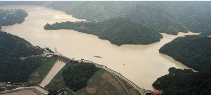
17 Sedimentation Issues in Shihmen Reservoir Rate of capacity decreasing: 1,840,000 m 3 /year

18 Check dams
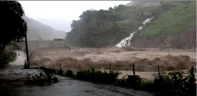
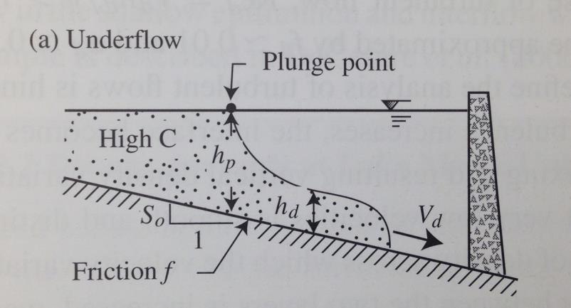
19 Sedimentation Issues in Shihmen Reservoir Density currents

20 Modification Modify power plant penstock to sluicing tunnel
 Q = 300 cms C = 37,400")
21 Sluicing Operation During Typhoon Soulik (2013) Q = 300 cms C = 37,400 ppm
22 Conclusions Sediment yields vary over a given year (due to climatic influences such as snow) so it is important to know the range when performing estimates A large portion of a watershed s sediment yield may occur in a short amount of time due to extreme events (rather than gradually over time) Sediment yield observations are important during high events, however many measurements are not available when the events are extreme (Frenette and Julien, 1996) Identifying accurate predictions of sediment yield can be difficult but is necessary in order to properly size reservoirs and determine lifespans. Dam construction requires the consideration of sedimentation for the storage and release of sediment over its lifetime.
CASE STUDY NATHPA JHAKRI, INDIA
 SEDIMENT MANAGEMENT CASE STUDY NATHPA JHAKRI, INDIA Key project features Name: Nathpa Jhakri Country: India Category: reduce sediment production (watershed management); upstream sediment trapping; bypass
CASE STUDY NATHPA JHAKRI, INDIA
 SEDIMENT MANAGEMENT CASE STUDY NATHPA JHAKRI, INDIA Key project features Name: Nathpa Jhakri Country: India Category: reforestation/revegetation; upstream sediment trapping; bypass channel/tunnel; reservoir
GEOL 1121 Earth Processes and Environments
 GEOL 1121 Earth Processes and Environments Wondwosen Seyoum Department of Geology University of Georgia e-mail: seyoum@uga.edu G/G Bldg., Rm. No. 122 Seyoum, 2015 Chapter 6 Streams and Flooding Seyoum,
River Response. Sediment Water Wood. Confinement. Bank material. Channel morphology. Valley slope. Riparian vegetation.
 River Response River Response Sediment Water Wood Confinement Valley slope Channel morphology Bank material Flow obstructions Riparian vegetation climate catchment vegetation hydrological regime channel
3/3/2013. The hydro cycle water returns from the sea. All "toilet to tap." Introduction to Environmental Geology, 5e
 Introduction to Environmental Geology, 5e Running Water: summary in haiku form Edward A. Keller Chapter 9 Rivers and Flooding Lecture Presentation prepared by X. Mara Chen, Salisbury University The hydro
Influence of the Major Drainages to the Mississippi River and Implications for System Level Management
 Influence of the Major Drainages to the Mississippi River and Implications for System Level Management Brian M. Vosburg Geologist Louisiana Coastal Protection and Restoration Authority brian.vosburg@la.gov
State Water Survey Division SURFACE WATER SECTION
 State Water Survey Division SURFACE WATER SECTION AT THE UNIVERSITY OF ILLINOIS Illinois Department of Energy and Natural Resources SWS Miscellaneous Publication 88 SEDIMENTATION OF POOL 19 ON THE MISSISSIPPI
Subject Name: SOIL AND WATER CONSERVATION ENGINEERING 3(2+1) COURSE OUTLINE
 COURSE OUTLINE") Subject Name: SOIL AND WATER CONSERVATION ENGINEERING 3(2+1) COURSE OUTLINE (Name of Course Developer: Prof. Ashok Mishra, AgFE Department, IIT Kharagpur, Kharagpur 721 302) Module 1: Introduction and
Subject Name: SOIL AND WATER CONSERVATION ENGINEERING 3(2+1) COURSE OUTLINE (Name of Course Developer: Prof. Ashok Mishra, AgFE Department, IIT Kharagpur, Kharagpur 721 302) Module 1: Introduction and
UGRC 144 Science and Technology in Our Lives/Geohazards
 UGRC 144 Science and Technology in Our Lives/Geohazards Flood and Flood Hazards Dr. Patrick Asamoah Sakyi Department of Earth Science, UG, Legon College of Education School of Continuing and Distance Education
STUDY GUIDE FOR CONTENT MASTERY. Surface Water Movement
 Surface Water SECTION 9.1 Surface Water Movement In your textbook, read about surface water and the way in which it moves sediment. Complete each statement. 1. An excessive amount of water flowing downslope
Strategies for managing sediment in dams. Iwona Conlan Consultant to IKMP, MRCS
 Strategies for managing sediment in dams Iwona Conlan Consultant to IKMP, MRCS 1 Sediment trapping by dams Active storage capacity Dead storage coarse material (bed load) Fine materials (suspension) Francis
CASE STUDY BINGA, PHILIPPINES
 SEDIMENT MANAGEMENT CASE STUDY BINGA, PHILIPPINES Key project features Name: Binga Country: Philippines Category: modify operating rule (focus or redistribute sediment); adaptive strategies Reservoir volume
Long-Term Effects Of River Bed Variations Downstream Of The Shihmen Reservoir Due To Climate Change
 City University of New York (CUNY) CUNY Academic Works International Conference on Hydroinformatics 8-1-2014 Long-Term Effects Of River Bed Variations Downstream Of The Shihmen Reservoir Due To Climate
Tarbela Dam in Pakistan. Case study of reservoir sedimentation
 Tarbela Dam in Pakistan. HR Wallingford, Wallingford, UK Published in the proceedings of River Flow 2012, 5-7 September 2012 Abstract Reservoir sedimentation is a main concern in the Tarbela reservoir
Environmental Geology Chapter 9 Rivers and Flooding
 Environmental Geology Chapter 9 Rivers and Flooding Flooding in Pakistan 2010-1600 killed/20000 affected The hydrologic cycle is powered by the Sun The cycle includes evaporation, precipitation, infiltration,
CASE STUDY BINGA, PHILIPPINES
 SEDIMENT MANAGEMENT CASE STUDY BINGA, PHILIPPINES Key project features Name: Binga Country: Philippines Category: modify operating rule (focus or redistribute sediment); adaptive strategies Binga hydropower
Floods Lecture #21 20
 Floods 20 Lecture #21 What Is a Flood? Def: high discharge event along a river! Due to heavy rain or snow-melt During a flood, a river:! Erodes channel o Deeper & wider! Overflows channel o Deposits sediment
WATER ON AND UNDER GROUND. Objectives. The Hydrologic Cycle
 WATER ON AND UNDER GROUND Objectives Define and describe the hydrologic cycle. Identify the basic characteristics of streams. Define drainage basin. Describe how floods occur and what factors may make
Each basin is surrounded & defined by a drainage divide (high point from which water flows away) Channel initiation
 Channel initiation") DRAINAGE BASINS A drainage basin or watershed is defined from a downstream point, working upstream, to include all of the hillslope & channel areas which drain to that point Each basin is surrounded &
DRAINAGE BASINS A drainage basin or watershed is defined from a downstream point, working upstream, to include all of the hillslope & channel areas which drain to that point Each basin is surrounded &
ENGINEERING HYDROLOGY
 ENGINEERING HYDROLOGY Prof. Rajesh Bhagat Asst. Professor Civil Engineering Department Yeshwantrao Chavan College Of Engineering Nagpur B. E. (Civil Engg.) M. Tech. (Enviro. Engg.) GCOE, Amravati VNIT,
Stream Geomorphology. Leslie A. Morrissey UVM July 25, 2012
 Stream Geomorphology Leslie A. Morrissey UVM July 25, 2012 What Functions do Healthy Streams Provide? Flood mitigation Water supply Water quality Sediment storage and transport Habitat Recreation Transportation
How Do Human Impacts and Geomorphological Responses Vary with Spatial Scale in the Streams and Rivers of the Illinois Basin?
 How Do Human Impacts and Geomorphological Responses Vary with Spatial Scale in the Streams and Rivers of the Illinois Basin? Bruce Rhoads Department of Geography University of Illinois at Urbana-Champaign
National Hydrology committee of Afghanistan (NHCA) Sedimentation in Reservoire
 Sedimentation in Reservoire") National Hydrology committee of Afghanistan (NHCA) Sedimentation in Reservoire OCt.2007 Prof. Mohammad Qasem Seddeqy KPU بسم االله الرحمن الرحيم وجعلنامن الماءکل شي ء حی 30 واز ا ب هر چيزی رازنده گردانيدیم
National Hydrology committee of Afghanistan (NHCA) Sedimentation in Reservoire OCt.2007 Prof. Mohammad Qasem Seddeqy KPU بسم االله الرحمن الرحيم وجعلنامن الماءکل شي ء حی 30 واز ا ب هر چيزی رازنده گردانيدیم
mountain rivers fixed channel boundaries (bedrock banks and bed) high transport capacity low storage input output
 high transport capacity low storage input output") mountain rivers fixed channel boundaries (bedrock banks and bed) high transport capacity low storage input output strong interaction between streams & hillslopes Sediment Budgets for Mountain Rivers Little
mountain rivers fixed channel boundaries (bedrock banks and bed) high transport capacity low storage input output strong interaction between streams & hillslopes Sediment Budgets for Mountain Rivers Little
INFLOW DESIGN FLOOD CONTROL SYSTEM PLAN 40 C.F.R. PART PLANT YATES ASH POND 2 (AP-2) GEORGIA POWER COMPANY
 GEORGIA POWER COMPANY") INFLOW DESIGN FLOOD CONTROL SYSTEM PLAN 40 C.F.R. PART 257.82 PLANT YATES ASH POND 2 (AP-2) GEORGIA POWER COMPANY EPA s Disposal of Coal Combustion Residuals from Electric Utilities Final Rule (40 C.F.R.
INFLOW DESIGN FLOOD CONTROL SYSTEM PLAN 40 C.F.R. PART 257.82 PLANT YATES ASH POND 2 (AP-2) GEORGIA POWER COMPANY EPA s Disposal of Coal Combustion Residuals from Electric Utilities Final Rule (40 C.F.R.
Remaining Capacity in Great Lakes Reservoirs
 US Army Corps of Engineers Detroit District Remaining Capacity in Great Lakes Reservoirs Storage Capacity Behind Great Lakes Dams Field Data and Modeling Motivation for project Project overview Data and
Suspended sediment yields of rivers in Turkey
 Erosion and Sediment Yield: Global and Regional Perspectives (Proceedings of the Exeter Symposium, July 1996). IAHS Publ. no. 236, 1996. 65 Suspended sediment yields of rivers in Turkey FAZLI OZTURK Department
Sedimentation in the Nile River
 Advanced Training Workshop on Reservoir Sedimentation Sedimentation in the Nile River Prof. Dr. Abdalla Abdelsalam Ahmed 10-16 Oct. 2007, IRTCES, Beijing, China CWR,Sudan 1 Water is essential for mankind
GIS Application in Landslide Hazard Analysis An Example from the Shihmen Reservoir Catchment Area in Northern Taiwan
 GIS Application in Landslide Hazard Analysis An Example from the Shihmen Reservoir Catchment Area in Northern Taiwan Chyi-Tyi Lee Institute of Applied Geology, National Central University, No.300, Jungda
A distributed runoff model for flood prediction in ungauged basins
 Predictions in Ungauged Basins: PUB Kick-off (Proceedings of the PUB Kick-off meeting held in Brasilia, 2 22 November 22). IAHS Publ. 39, 27. 267 A distributed runoff model for flood prediction in ungauged
Technical Review of Pak Beng Hydropower Project (1) Hydrology & Hydraulics and (2) Sediment Transport & River Morphology
 Hydrology & Hydraulics and (2) Sediment Transport & River Morphology") Technical Review of Pak Beng Hydropower Project (1) Hydrology & Hydraulics and (2) Sediment Transport & River Morphology The 2 nd Regional Stakeholder Forum The Pak Beng Hydropower Project 5 th May 2017
Technical Review of Pak Beng Hydropower Project (1) Hydrology & Hydraulics and (2) Sediment Transport & River Morphology The 2 nd Regional Stakeholder Forum The Pak Beng Hydropower Project 5 th May 2017
Overview of fluvial and geotechnical processes for TMDL assessment
 Overview of fluvial and geotechnical processes for TMDL assessment Christian F Lenhart, Assistant Prof, MSU Research Assoc., U of M Biosystems Engineering Fluvial processes in a glaciated landscape Martin
Watershed Processes and Modeling
 Watershed Processes and Modeling Pierre Y. Julien Hyeonsik Kim Department of Civil Engineering Colorado State University Fort Collins, Colorado Kuala Lumpur - May Objectives Brief overview of Watershed
Hydraulics Prof. Dr. Arup Kumar Sarma Department of Civil Engineering Indian Institute of Technology, Guwahati
 Hydraulics Prof. Dr. Arup Kumar Sarma Department of Civil Engineering Indian Institute of Technology, Guwahati Module No. # 04 Gradually Varied Flow Lecture No. # 07 Rapidly Varied Flow: Hydraulic Jump
Science EOG Review: Landforms
 Mathematician Science EOG Review: Landforms Vocabulary Definition Term canyon deep, large, V- shaped valley formed by a river over millions of years of erosion; sometimes called gorges (example: Linville
CAUSES FOR CHANGE IN STREAM-CHANNEL MORPHOLOGY
 CAUSES FOR CHANGE IN STREAM-CHANNEL MORPHOLOGY Chad A. Whaley, Department of Earth Sciences, University of South Alabama, MobileAL, 36688. E-MAIL: caw408@jaguar1.usouthal.edu The ultimate goal of this
Appendix K.2: Sediment Management Excerpt from South Orange County Hydromodification Management Plan
 Appendix K.2: Sediment Management Excerpt from South Orange County Hydromodification Management Plan 4 Sediment Supply Management Requirements Permit Order R9-2013-0001 as amended by Order No. R9-2015-0001Section
Illinois State Water Survey Division
 Illinois State Water Survey Division SURFACE WATER SECTION SWS Miscellaneous Publication 108 SEDIMENT YIELD AND ACCUMULATION IN THE LOWER CACHE RIVER by Misganaw Demissie Champaign, Illinois June 1989
Application of SWAT Model to Estimate the Runoff and Sediment Load from the Right Bank Valleys of Mosul Dam Reservoir
 Application of SWAT Model to Estimate the Runoff and Sediment Load from the Right Bank Valleys of Mosul Dam Reservoir Dr Mohammad Ezeel Deen Prof. Nadhir Al-Ansari Prof Sven Knutsson Figure 1.Map of Iraq
B-1. Attachment B-1. Evaluation of AdH Model Simplifications in Conowingo Reservoir Sediment Transport Modeling
 Attachment B-1 Evaluation of AdH Model Simplifications in Conowingo Reservoir Sediment Transport Modeling 1 October 2012 Lower Susquehanna River Watershed Assessment Evaluation of AdH Model Simplifications
Surface Water and Stream Development
 Surface Water and Stream Development Surface Water The moment a raindrop falls to earth it begins its return to the sea. Once water reaches Earth s surface it may evaporate back into the atmosphere, soak
Surface Processes Focus on Mass Wasting (Chapter 10)
") Surface Processes Focus on Mass Wasting (Chapter 10) 1. What is the distinction between weathering, mass wasting, and erosion? 2. What is the controlling force in mass wasting? What force provides resistance?
Surface Processes Focus on Mass Wasting (Chapter 10) 1. What is the distinction between weathering, mass wasting, and erosion? 2. What is the controlling force in mass wasting? What force provides resistance?
Running Water Earth - Chapter 16 Stan Hatfield Southwestern Illinois College
 Running Water Earth - Chapter 16 Stan Hatfield Southwestern Illinois College Hydrologic Cycle The hydrologic cycle is a summary of the circulation of Earth s water supply. Processes involved in the hydrologic
Surface Water Short Study Guide
 Name: Class: Date: Surface Water Short Study Guide Multiple Choice Identify the letter of the choice that best completes the statement or answers the question. 1. The three ways in which a stream carries
DETERMINATION OF SEDIMENT TRAP EFFICIENCY OF SMALL WATER RESERVOIR AT KREMPNA
 Determination of sediment trap efficiency INFRASTRUKTURA I EKOLOGIA TERENÓW WIEJSKICH INFRASTRUCTURE AND EKOLOGY OF RURAL AREAS Nr 3/2007, POLSKA AKADEMIA NAUK, Oddział w Krakowie, s. 161 170 Komisja Technicznej
NATURAL RIVER. Karima Attia Nile Research Institute
 NATURAL RIVER CHARACTERISTICS Karima Attia Nile Research Institute NATURAL RIVER DEFINITION NATURAL RIVER DEFINITION Is natural stream of water that flows in channels with ih more or less defined banks.
Technical Memorandum No
 Pajaro River Watershed Study in association with Technical Memorandum No. 1.2.10 Task: Evaluation of Four Watershed Conditions - Sediment To: PRWFPA Staff Working Group Prepared by: Gregory Morris and
Stream Restoration and Environmental River Mechanics. Objectives. Pierre Y. Julien. 1. Peligre Dam in Haiti (deforestation)
") Stream Restoration and Environmental River Mechanics Pierre Y. Julien Malaysia 2004 Objectives Brief overview of environmental river mechanics and stream restoration: 1. Typical problems in environmental
Stream Restoration and Environmental River Mechanics Pierre Y. Julien Malaysia 2004 Objectives Brief overview of environmental river mechanics and stream restoration: 1. Typical problems in environmental
ES 105 Surface Processes I. Hydrologic cycle A. Distribution % in oceans 2. >3% surface water a. +99% surface water in glaciers b.
 ES 105 Surface Processes I. Hydrologic cycle A. Distribution 1. +97% in oceans 2. >3% surface water a. +99% surface water in glaciers b. >1/3% liquid, fresh water in streams and lakes~1/10,000 of water
Analysis of Sedimentation in Wonogiri Reservoir
 Journal of the Civil Engineering Forum Vol. 2 No. 1 (January 2016) Analysis of Sedimentation in Wonogiri Reservoir Tri Joko Inti Budi Santosa Large River Basin Organization of Bengawan Solo, Surakarta,
Figure 1. Which part of the river is labelled in Figure 1? a) Mouth b) Source c) Lower course d) channel
 Mouth b) Source c) Lower course d) channel") Rivers 1. Study Figure 1 showing the long profile of a river Figure 1 A Which part of the river is labelled in Figure 1? a) Mouth b) Source c) Lower course d) channel (1 mark) 2. Complete the sentences
Rivers 1. Study Figure 1 showing the long profile of a river Figure 1 A Which part of the river is labelled in Figure 1? a) Mouth b) Source c) Lower course d) channel (1 mark) 2. Complete the sentences
SECTION G SEDIMENT BUDGET
 SECTION G SEDIMENT BUDGET INTRODUCTION A sediment budget has been constructed for the for the time period 1952-2000. The purpose of the sediment budget is to determine the relative importance of different
Summary. Streams and Drainage Systems
 Streams and Drainage Systems Summary Streams are part of the hydrologic cycle and the chief means by which water returns from the land to the sea. They help shape the Earth s surface and transport sediment
Science of Natural Disasters: RIVERS& FLOODS! 27 April 2016
 Science of Natural Disasters: RIVERS& FLOODS! 27 April 2016 Rebecca Clotts Department of Geology, University of St Thomas Flood in St Paul, 2014, Star Tribune 1 2 What is a watershed? 3 4 5 6 7 What is
Which map shows the stream drainage pattern that most likely formed on the surface of this volcano? A) B)
 B)") 1. When snow cover on the land melts, the water will most likely become surface runoff if the land surface is A) frozen B) porous C) grass covered D) unconsolidated gravel Base your answers to questions
1. When snow cover on the land melts, the water will most likely become surface runoff if the land surface is A) frozen B) porous C) grass covered D) unconsolidated gravel Base your answers to questions
RESERVOIR SEDIMENTATION MANAGEMENT WITH BYPASS TUNNELS IN JAPAN. Keywords: Reservoir sedimentation, Sediment bypass, Diversion tunnel, Abrasion damage
 Proceedings of the Ninth International Symposium on River Sedimentation October 18 21, 2004, Yichang, China RESERVOIR SEDIMENTATION MANAGEMENT WITH BYPASS TUNNELS IN JAPAN Tetsuya SUMI Graduate School
Optimal Artificial Neural Network Modeling of Sedimentation yield and Runoff in high flow season of Indus River at Besham Qila for Terbela Dam
 Optimal Artificial Neural Network Modeling of Sedimentation yield and Runoff in high flow season of Indus River at Besham Qila for Terbela Dam Akif Rahim 1, Amina Akif 2 1 Ph.D Scholar in Center of integrated
Fresh Water: Streams, Lakes Groundwater & Wetlands
 Fresh Water:, Lakes Groundwater & Wetlands Oct 27 Glaciers and Ice Ages Chp 13 Nov 3 Deserts and Wind and EXAM #3 Slope hydrologic cycle P = precip I = precip intercepted by veg ET = evapotranspiration
Earth Science Chapter 6 Section 2 Review
 Name: Class: Date: Earth Science Chapter 6 Section Review Multiple Choice Identify the choice that best completes the statement or answers the question. 1. Most streams carry the largest part of their
MATHEMATICAL MODELING OF FLUVIAL SEDIMENT DELIVERY, NEKA RIVER, IRAN. S.E. Kermani H. Golmaee M.Z. Ahmadi
 JOURNAL OF ENVIRONMENTAL HYDROLOGY The Electronic Journal of the International Association for Environmental Hydrology On the World Wide Web at http://www.hydroweb.com VOLUME 16 2008 MATHEMATICAL MODELING
OBJECTIVES. Fluvial Geomorphology? STREAM CLASSIFICATION & RIVER ASSESSMENT
 STREAM CLASSIFICATION & RIVER ASSESSMENT Greg Babbit Graduate Research Assistant Dept. Forestry, Wildlife & Fisheries Seneca Creek, Monongahela National Forest, West Virginia OBJECTIVES Introduce basic
Year 6. Geography. Revision
 Year 6 Geography Revision November 2017 Rivers and World knowledge How the water cycle works and the meaning of the terms evaporation, condensation, precipitation, transpiration, surface run-off, groundwater
Griswold Creek August 22, 2013
 Creek August 22, 2013 1 Lake Erie Protection Fund Creek Study ver Evaluate the overall condition of Creek Determine stable channel dimensions & appropriate restoration techniques Starting Stat gpoint for
Diagnostic Geomorphic Methods for Understanding Future Behavior of Lake Superior Streams What Have We Learned in Two Decades?
 Diagnostic Geomorphic Methods for Understanding Future Behavior of Lake Superior Streams What Have We Learned in Two Decades? Faith Fitzpatrick USGS WI Water Science Center, Middleton, WI fafitzpa@usgs.gov
River Restoration and Rehabilitation. Pierre Y. Julien
 River Restoration and Rehabilitation Pierre Y. Julien Department of Civil and Environmental Engineering Colorado State University Fort Collins, Colorado River Mechanics and Sediment Transport Lima Peru
Sediment Deposition LET THE RIVER RUN T E A C H E R. Activity Overview. Activity at a Glance. Time Required. Level of Complexity.
 Activity at a Glance Grade: 6 9 Subject: Science Category: Physical Science, Earth Science Topic: Deposition, River Systems Time Required Two 45-minute periods Level of Complexity Medium Materials* TI-73
Monitoring of suspended sediment concentration in discharge from regulated lakes in glacial deposits
 Erosion and Sediment Transport Monitoring Programmes in River Basins (Proceedings of the Oslo Symposium, August 1992). IAHS Publ. no. 210, 1992. 269 Monitoring of suspended sediment concentration in discharge
Session: For more information:
 Session: For more information: www.hydropower.org/congress San Juan, Puerto Rico www.glmengineers.com 2015 World Hydropower Congress Sustainable Sediment Management and Hydropower Reservoirs 21 May 2015
Important Copyright Information
 Important Copyright Information The following content is provided for educational purposes by the workshop presenter. This content may or may not have been peer reviewed. Information, opinions and recommendations
The Effects of Hydraulic Structures on Streams Prone to Bank Erosion in an Intense Flood Event: A Case Study from Eastern Hokkaido
 Symposium Proceedings of the INTERPRAENENT 2018 in the Pacific Rim The Effects of Hydraulic Structures on Streams Prone to Bank Erosion in an Intense Flood Event: A Case Study from Eastern Hokkaido Daisuke
8 Current Issues and Research on Sediment Movement in the River Catchments of Japan
 8 Current Issues and Research on Sediment Movement in the River Catchments of Japan YUTAKA ICHIKAWA INTRODUCTION Prediction of sediment movement is one of the challenging tasks in water-related research.
Streams. Stream Water Flow
 CHAPTER 14 OUTLINE Streams: Transport to the Oceans Does not contain complete lecture notes. To be used to help organize lecture notes and home/test studies. Streams Streams are the major geological agents
SEDIMENT MANAGEMENT IN HYDROPOWER PLANTS AN OVERVIEW
 International Conference on Hydropower for Sustainable Development Feb 05-07, 2015, Dehradun SEDIMENT MANAGEMENT IN HYDROPOWER PLANTS AN OVERVIEW P.K. Pande, Former Professor of Civil Engineering, University
In the space provided, write the letter of the description that best matches the term or phrase. a. any form of water that falls to Earth s
 Skills Worksheet Concept Review In the space provided, write the letter of the description that best matches the term or phrase. 1. condensation 2. floodplain 3. watershed 4. tributary 5. evapotranspiration
Conservation Planning evaluate land management alternatives to reduce soil erosion to acceptable levels. Resource Inventories estimate current and
 Conservation Planning evaluate land management alternatives to reduce soil erosion to acceptable levels. Resource Inventories estimate current and projected erosion levels and their impact on natural resource
The subject paper is being submitted for approval for publication in the annual volume entitled Geological Survey Research.
 Water Resources Division 345 Middlefield Road Menlo Park, California January 12, 1965 Memorandum To: Mr. Frank E. Clark, Chief, General Hydrology Branch Thru: Area Hydrologist PCA From: Valmore C. LaMarche
7.3 Sediment Delivery Analysis
 7.3 Sediment Delivery Analysis In order to evaluate potential changes in sedimentation patterns that could occur due to impacts from the FCP and LPP alignments, sediment assessment models were constructed
Nutrient and Sediment Cycling and Retention in Urban Floodplain Wetlands
 Nutrient and Sediment Cycling and Retention in Urban Floodplain Wetlands Greg Noe, Cliff Hupp, Nancy Rybicki, Ed Schenk, and Jackie Batson National Research Program, Reston VA U.S. Department of the Interior
Lecture Outlines PowerPoint. Chapter 5 Earth Science 11e Tarbuck/Lutgens
 Lecture Outlines PowerPoint Chapter 5 Earth Science 11e Tarbuck/Lutgens 2006 Pearson Prentice Hall This work is protected by United States copyright laws and is provided solely for the use of instructors
Mountain Rivers. Gutta cavat lapidem. (Dripping water hollows out a stone) -Ovid, Epistulae Ex Ponto, Book 3, no. 10, 1. 5
 -Ovid, Epistulae Ex Ponto, Book 3, no. 10, 1. 5") Mountain Rivers Gutta cavat lapidem (Dripping water hollows out a stone) -Ovid, Epistulae Ex Ponto, Book 3, no. 10, 1. 5 Mountain Rivers Fixed channel boundaries (bedrock banks and bed) High transport
Mountain Rivers Gutta cavat lapidem (Dripping water hollows out a stone) -Ovid, Epistulae Ex Ponto, Book 3, no. 10, 1. 5 Mountain Rivers Fixed channel boundaries (bedrock banks and bed) High transport
Sediment yield estimation from a hydrographic survey: A case study for the Kremasta reservoir, Western Greece
 Sediment yield estimation from a hydrographic survey: A case study for the Kremasta reservoir, Western Greece 5 th International Conference Water Resources Management in the Era of Transition,, Athens,
Catastrophic Events Impact on Ecosystems
 Catastrophic Events Impact on Ecosystems Hurricanes Hurricanes An intense, rotating oceanic weather system with sustained winds of at least 74 mph and a welldefined eye Conditions for formation: Warm water
Recent Changes of Suspended Sediment Yields in the Upper Yangtze River and Its Headwater Tributaries
 Modern Environmental Science and Engineering (ISSN 2333-2581) July 2015, Volume 1, No. 2, pp. 64-71 Doi: 10.15341/mese(2333-2581)/02.01.2015/002 Academic Star Publishing Company, 2015 www.academicstar.us
The SedAlp Project: WP6: INTERACTION WITH STRUCTURES
 The SedAlp Project: WP6: INTERACTION WITH STRUCTURES 6 th International conference Water in the Alps Herrenchiemsee, 12 th of October, 2016 Jošt Sodnik Contents Structure of SedAlp project (www.sedalp.eu)
Summary of Hydraulic and Sediment-transport. Analysis of Residual Sediment: Alternatives for the San Clemente Dam Removal/Retrofit Project,
 Appendix N SUMMARY OF HYDRAULIC AND SEDIMENT-TRANSPORT ANALYSIS OF RESIDUAL SEDIMENT: ALTERNATIVES FOR THE SAN CLEMENTE DAM REMOVAL/RETROFIT PROJECT, CALIFORNIA the San Clemente Dam Removal/Retrofit Project,
Standards for Soil Erosion and Sediment Control in New Jersey May 2012
 STANDARD FOR SEDIMENT BASIN Definition A barrier, dam, excavated pit, or dugout constructed across a waterway or at other suitable locations to intercept and retain sediment. Basins created by construction
Roger Andy Gaines, Research Civil Engineer, PhD, P.E.
 Roger Andy Gaines, Research Civil Engineer, PhD, P.E. Research Civil Engineer/Regional Technical Specialist Memphis District August 24, 2010 Objectives Where we have been (recap of situation and what s
An investigation on the impacts of density currents on the sedimentation in dam reservoirs using TCM model; case study: Maroon dam
 University of Wollongong Research Online Faculty of Engineering and Information Sciences - Papers: Part A Faculty of Engineering and Information Sciences 2013 An investigation on the impacts of density
Recent changes of suspended sediment yields in the Upper Yangtze River and its headwater tributaries
 Sediment Dynamics from the Summit to the Sea 297 (Proceedings of a symposium held in New Orleans, Louisiana, USA, 11 14 December 2014) (IAHS Publ. 367, 2014). Recent changes of suspended sediment yields
Sediment Trap. A temporary runoff containment area, which promotes sedimentation prior to discharge of the runoff through a stabilized spillway.
 Sediment Trap SC-15 Source: Caltrans Construction Site Best Management Practices Manual, 2003. Description A temporary runoff containment area, which promotes sedimentation prior to discharge of the runoff
The effectiveness of check dams in controlling upstream channel stability in northeastern Taiwan
 Erosion, Debris Mows and Environment in Mountain Regions (Proceedings of the Chengdu Symposium, July 1992). IAHS Publ. no. 209, 1992. 423 The effectiveness of check dams in controlling upstream channel
SESSION 6: FLUVIAL LANDFORMS
 SESSION 6: FLUVIAL LANDFORMS KEY CONCEPTS: Fluvial Landforms Management of River Catchment Areas Slope Elements X-PLANATION: FLUVIAL LANDFORMS Rivers form landforms as they erode the landscape. These landforms
Use of SWAT to Scale Sediment Delivery from Field to Watershed in an Agricultural Landscape with Depressions
 Use of SWAT to Scale Sediment Delivery from Field to Watershed in an Agricultural Landscape with Depressions James E. Almendinger St. Croix Watershed Research Station, Science Museum of Minnesota Marylee
Engineering Hydrology
 Engineering Hydrology Prof. Rajesh Bhagat Asst. Professor Civil Engineering Department Yeshwantrao Chavan College Of Engineering Nagpur B. E. (Civil Engg.) M. Tech. (Enviro. Engg.) GCOE, Amravati VNIT,
Assessment of Lake Forest Lake Sediment Trapping Efficiency and Capacity. Marlon R. Cook Groundwater Assessment Program Geological Survey of Alabama
 Assessment of Lake Forest Lake Sediment Trapping Efficiency and Capacity Marlon R. Cook Groundwater Assessment Program Geological Survey of Alabama Impacts of the Lake at Lake Forest on the connectivity
GIS model & modeling
 GIS model & modeling Model : a simplified representation of a phenomenon or a system. GIS modeling : the use of GIS in the process of building models with spatial data. Basic requirement in modeling :
Landscape Development
 Landscape Development Slopes Dominate Natural Landscapes Created by the interplay of tectonic and igneous activity and gradation Deformation and uplift Volcanic activity Agents of gradation Mass wasting
Influence of the timing of flood events on sediment yield in the north-western Algeria
 Calabria, 5-7 Septembre 2 4th International Workshop on Hydrological Extremes Session A : Modelling and forecast of hydrological extreme event Influence of the timing of flood events on sediment yield
Swift Creek Sediment Management Action Plan (SCSMAP)
") Swift Creek Sediment Management Action Plan (SCSMAP) PHASE 2 PROJECT PLAN PROPOSAL Whatcom County Public Works Department 322 N. Commercial Street, Suite 210 Bellingham, WA 98225 (360) 676-6692 June 2013
Swift Creek Sediment Management Action Plan (SCSMAP) PHASE 2 PROJECT PLAN PROPOSAL Whatcom County Public Works Department 322 N. Commercial Street, Suite 210 Bellingham, WA 98225 (360) 676-6692 June 2013
The relationship between drainage density and soil erosion rate: a study of five watersheds in Ardebil Province, Iran
 River Basin Management VIII 129 The relationship between drainage density and soil erosion rate: a study of five watersheds in Ardebil Province, Iran A. Moeini 1, N. K. Zarandi 1, E. Pazira 1 & Y. Badiollahi