The new challenge of community-based environmental monitoring and information systems: the Citizens Obsrevatories Tito Scalo (PZ) 13 July 2016
|
|
|
- Theresa Morris
- 5 years ago
- Views:
Transcription
1 The new challenge of community-based environmental monitoring and information systems: the Citizens Obsrevatories Tito Scalo (PZ) 13 July 2016 Involving citizens in environmental monitoring and awareness: examples of local and European initiatives in Basilicata region Valerio Tramutoli University of Basilicata & IMAA- CNR Italy NEREUS EO/Copernicus WG - chair valerio.tramutoli@unibas.it


2 Citizen Obsevatories Potential Demonstrations Five Fp7 (mostly at their end) Projects funded by EC ENV "Developing community based environmental monitoring and information systems using innovative and novel earth observation applications." Citi-sense Citclops COBWEB Omniscientis WeSenseIt A common website Dedicated calls in H2020.


3 A EC-GEO Flag initiative


4 Citizen Obsevatories for Emergency and Security issues: a new challenge Specific constraints on information: Quality Timeliness Final use Higher potential of citizen engagement thanks to the possibility to offer timely and updated information on what to do during the emergency.


5 Citizen Obsevatories for Emergency and Security issues: a new challenge Specific issues: Data providers Identification Data validation Data use Information distribution Legal responsabilities.


 High risk area (seismic,")
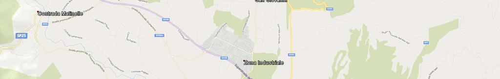
6 Citizen Observatories added value Example 1: Monitoring industrial plants in very delicate environmental contexts Val d Agri valley Important natural resources (oil, water, agriculture, tourism, etc.) High risk area (seismic, industrial, hydrologic, etc.)

 Feedback possible")
7 Citizen Observatories added value Citizen Observatories added value Example 1: Val d Agri Valley Omniscientist paradigma implemented in real-time scenarios with: Citizen scared by possible effects of oil plant emissions ask to contribute to monitor it Unique contribute from human senses (as odour cannot be precisely monitored like other pollutants) Feedback possible on other risks


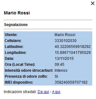
8 Citizen Observatories added value Providing geolocated odour observations possibly related to oil plant activity or malfunctioning Puzza App

9 Citizen Observatories added value citizen identification required

10 Citizen Observatories added value condition of use subscribed


11 Citizen Observatories added value easy to use


12 Citizen Observatories added value start ing with hydrocarbons and sulfur


13 Citizen Observatories added value

14 Citizen Observatories added value to be used in combination with traditional observations


15 Citizen Observatories added value to be used in combination with traditional observations


16 Citizen Observatories added value in the framework of a centralized monitoring system

 detected by RST on METEOSAT/SEVIRI data")

17 Citizen Observatories added value to be used in combination with advanced satellite systems Flame burst at the Oil Center of Viggiano Italy (20/11/ 2008) detected by RST on METEOSAT/SEVIRI data Correcting official reports RST Anomaly identified at 18:15 LT (i.e. 2 hours before than reported by ENI!)


18 Citizen & Satellite Observations added value for emergency and security issues Forest fires e.g. Fires in Italy, February 2005 Volcanic Eruptions Floods e.g. Etna eruption Oct 2002 e.g. Ungary flood, April 2002 Dust storms e.g.libia 13 May 2004 SZOLNOK Voltri TISZA TISZAVARKONY TISZAJENE VEZSENY Erli Casanova Lerrone TISZASAS Carpasio Ash Clouds fires Oil spills e.g. Oil spill in the Persic Gulf, January 1991 Soil wetness e.g. Carpathian Basin, April 2000 Flooded areas Earthquakes e.g. 7 September 1999 Athens Earthquake Dust clouds Security (pipelines)) e.g. 18 October 2005 IRAQ 3 days before EQ Raining Clouds Weakly wet Oil spill Moderately wet Extremely wet Thermal anomalies Explosions

.")
")
19 Citizen & Satellite Observations added value Example 2: forest fires monitoring RST-FIRES for satellite monitoring of intensity of fires (with 15 minutes updating). detected fires Ground control/confirmation Additional alerts (to be monitored by satellite) Early alerts (smoke difficult to be detected by satellite)

.")

20 Citizen & Satellite Observations added value Example 2: forest fires monitoring RST-FIRES for satellite monitoring of intensity of fires (with 15 minutes updating). detected fires 23 July 2009 more than 200 requests for intervention vs only 30 Canadair available. Decision Support


")


21 Citizen & Satellite Observations added value Example 2 forest fires monitoring Ground control/confirmation Additional alerts (to be monitored by satellite) Early alerts (smoke difficult to be detected by satellite) METEOSAT/SEVIRI MIR signal measured at the selected point 08:00GMT 08:15GMT 08:30GMT 08:45GMT 09:00GMT 09:15GMT 09:30GMT 09:45GMT Real-time (15 min refreshing interval) satellite monitoring


 to coordinate and aggregate in real-time all")


22 Citizen & Satellite Observations added value Example 3: Short-term Seismic Hazard evaluation Already in the GEO WP DI-01 Informing Risk Management and Disaster Reduction 29 Ago 2014 M 5.7 C2 Geohazards Monitoring, Alert, and Risk Assessment Priority Actions.. Support global short-term earthquake hazard forecast assessment. Establish a global EarthQuake Observing System (EQuOS) to coordinate and aggregate in real-time all (ground and spacebased) observations suitable for improving, time-dependent, earthquake hazard estimates. Develop comprehensive datasets, based on validated data products and peer reviewed data analysis methods, initially focusing on selected seismic areas (Supersites). But we can improve it by introducing the CO component
23 Example 3: Short-term Seismic Hazard evaluation Citizen Observatories added value Earth speaks you learn to listen Providing unique information for seismic hazard assessment (e.g. INGV Red Cross Project)
 http://www.")

24 Example 3: Short-term Seismic Hazard evaluation Citizen Observatories added value Earth speaks you learn to listen Providing unique information for seismic hazard assessment (e.g. INGV Red Cross Project) Contributing to the construction of immediate post-event scenarios (e.g. ground shaking maps using Citizens as Virtual Sensors: Did you Shake?)


 http://safer.chania.")
 information on what to do during all the phases")
25 Example 3: Short-term Seismic Hazard evaluation Citizen Observatories added value Earth speaks you learn to listen Providing unique information for seismic hazard assessment (e.g. INGV Red Cross Project) Contributing to the construction of immediate post-event scenarios (e.g. ground shaking maps using Citizens as Virtual Sensors: Did you Shake?) Receiving (personalized?) information on what to do during all the phases of seismic crisis (like within the I don t risk campaign of Italian Civil Protection)


 and")
")
26 The role of education: the GMES/Copernicus Academy Peter Zeil (University of Saltzburg) and Valerio Tramutoli (University of Basilicata) co-chairs


 data in different")
27 The role of education The Copernicus User Uptake EC Project Copernicus Academy experiment devoted to involve Basilicata high school students in complementing Copernicus (received) and Citizen Observatories (provided) data in different emergency contexts
28 Citizen Observatories in GEOSS: Citizen Observatories for Emergency and Security in GEOSS Citizen Observatories (already widely represented in the GEO WP) should be implemented also in the Disasters part of the WP where the impact could be very high Standards are important but direct contacts with mobile and sw producers will help GEOSS to accelerate the process (as standard de facto proceed more quickly)
29 Citizen Observatories future How to increase the confidence of scientists and authorities in citizens how to increase their participation? Education is of paramount importance and the possibility for the citizen to act also as Observer should be foreseen in all Civil Protection prevention activities (around the Resilient Community Concept) Unique entry point for all emergencies where citizen might found the way to receive and provide critical information Education + quality of the info is the only (and the best ) actual promotion (people do not need to be encouraged to use what they actually need) Central is the role of Regions and the other relevant Local Authorities which have to be involved as facilitator in all the above processes


30 Citizen Observatories future Thanks
31
Module 3 False ideas and other theoretical issues
 FORmation of Multi-disciplinary Approaches to Training in Earth Observation Erasmus Intensive Programmes Module 3 False ideas and other theoretical issues FORmation of Multi-disciplinary Approaches to
Geohazard Supersites and Natural Laboratories
 Geohazard Supersites and Natural Laboratories FRINGE 2011, Frascati, Italy, September 19, 2011 Wolfgang Lengert, ESA Falk Amelung, University of Miami, GEO task lead Craig Dobson, NASA, CEOS task lead
GEO Geohazards Community of Practice
 GEO Geohazards Community of Practice 1) Co-Chair of GHCP With input from: Stuart Marsh, GHCP Co-Chair Francesco Gaetani, GEO Secretariat and many GHCP contributors 1) Nevada Bureau of Mines and Geology
Copernicus Today and Tomorrow GEO Week Group on Earth Observation Geneva, 16 January 2014 The Copernicus Space Infrastructure
 Copernicus Today and Tomorrow GEO Week Group on Earth Observation Geneva, 16 January 2014 The Copernicus Space Infrastructure Thomas Beer, Policy Coordinator, Copernicus Space Office, ESA-ESRIN, Frascati
Monitoring and Warning Systems for Natural Phenomena The Mexican Experience
 Sistema Nacional de Protección Civil Monitoring and Warning Systems for Natural Phenomena The Mexican Experience Roberto Quaas W, Enrique Guevara O. O Mexican National Center for Disaster Prevention CENAPRED
GMES EURORISK Geo-information services for natural and man-made risks management
 GMES EURORISK Geo-information services for natural and man-made risks management 8/11/2004 EURORISK A European scale approach for developing, delivering and operationally exploiting new information services
V. Tramutoli Format EO Erasmus Intensive School Leicester July 2013
 ? Exaple 4: Volcanic Lava flow Detection Tradictional Methods (Harris et al., 1995) NOAA-16, Jul 23 2001 15 GMT AVHRR Channel 4 Suer Exaple 4: Volcanic Lava flow Detection RST NOAA-16, Jul 23 2001 15 GMT
Citizen Science at the. U.S. Geological Survey
 Citizen Science at the U.S. Geological Survey David Applegate USGS Associate Director for Natural Hazards NRC Board on Earth Science & Resources December 5, 2014 U.S. Department of the Interior U.S. Geological
The BEYOND Center of Excellence for monitoring natural disasters from space
 The BEYOND Center of Excellence for monitoring natural disasters from space Ioannis Papoutsis National Observatory of Athens Institute for Astronomy, Astrophysics, Space Applications & Remote Sensing MOWE-IT
Earth Observation and GEOSS in Horizon Copernicus for Raw Material Workshop 5 th September 2016
 Earth Observation and GEOSS in Horizon 2020 Copernicus for Raw Material Workshop 5 th September 2016 Gilles OLLIER Head of Sector -Earth observation Directorate Environment Unit I.4 Climate Actions and
the PREARTHQUAKES Project Valerio Tramutoli University of Basilicata
 the PREARTHQUAKES Project Valerio Tramutoli University of Basilicata ASI-GMES Roma 27 June 2012 Where we are DIFA University of Basilicata - Potenza Matera IMAA-CNR - Tito -(Potenza) Optical Band Meteorological
Multihazard Early Warning Systems: The European Meteoalarm Platform
 Multihazard Early Warning Systems: The European Meteoalarm Platform UN - ISDR Sendai Framework of Actions, 2015 Early warning criteria: users To develop and strengthen: people-centred multi-hazard forecasting
Geohazard Supersites and Natural Laboratories
 Geohazard Supersites and Natural Laboratories FRINGE 2011, Frascati, Italy, September 19, 2011 Wolfgang Lengert, ESA Falk Amelung, University of Miami, GEO task lead Craig Dobson, NASA, CEOS task lead
What Can Citizen Scientists Tell Us about Drought?
 What Can Citizen Scientists Tell Us about Drought? Amanda Brennan, Kirstin Dow, Benjamin Haywood, Kirsten Lackstrom American Meteorological Society Annual Meeting January 13, 2016 New Orleans, LA Today
Agency Vision and Decision- Maker Needs: A USGS Perspective
 Agency Vision and Decision- Maker Needs: A USGS Perspective Connecting Grassroots to Government for Disaster Management David Applegate USGS Associate Director for Natural Hazards September 13, 2012 U.S.
CONFERENCE STATEMENT
 CONFERENCE STATEMENT We, the elected representatives from Canada, Denmark/Greenland, Finland, Iceland, Norway, Russia, Sweden and the United States of America; In collaboration with the indigenous peoples
Copernicus Overview and Emergency Management Service
 Copernicus Overview and Emergency Management Service Frédéric BASTIDE European Commission Open informal session of the United Nations Inter-Agency Meeting on Outer Space Activities 12 March 2013, Geneva
GI Technology for Disaster Management
 GI Technology for Disaster Management 17 th ICC on the Regional Space Applications Programme for Sustainable Development (RESAP) 26 th Nov 2013 Bangkok Thailand Period and time of seasonal in thailand
Crisis Management and Natural Disasters Overview of JRC operational or pre-operational activities A. Annunziato, D. Al-Khudhairy
 Papagayo, Costarica 3-4 November 2009 Security Science and The Americas 1 Joint Research Centre (JRC) Crisis Management and Natural Disasters Overview of JRC operational or pre-operational activities A.
WMO. Key Elements of PWS and Effective EWS. Haleh Haleh Kootval Chief, PWS Programme
 WMO Key Elements of PWS and Effective EWS Haleh Haleh Kootval Chief, PWS Programme Workshop Objectives This workshop is all about Service Delivery and becoming excellent at it through: Sharing experiences
Landslide Hazard Assessment Methodologies in Romania
 A Scientific Network for Earthquake, Landslide and Flood Hazard Prevention SciNet NatHazPrev Landslide Hazard Assessment Methodologies in Romania In the literature the terms of susceptibility and landslide
Satellite Meteorology. Protecting Life and Property Around the World
 Satellite Meteorology Protecting Life and Property Around the World The Value of Forecasting Severe Weather Flooding events across Europe in August 2002 cost in the region of 20 billion; 20,000 people
Emergency Management Service (EMS) mapping
 mapping") GMES Emergency Management Service (EMS) mapping Frédéric BASTIDE GMES unit, European Commission UN-SPIDER Expert Meeting: "Crowdsource Mapping for Disaster Risk Management and Emergency Response" 3-5 December,
GMES Emergency Management Service (EMS) mapping Frédéric BASTIDE GMES unit, European Commission UN-SPIDER Expert Meeting: "Crowdsource Mapping for Disaster Risk Management and Emergency Response" 3-5 December,
Oregon APA Legal Issues Workshop December 7, Tricia Sears, DLCD With information from Bill Burns, DOGAMI
 Oregon APA Legal Issues Workshop December 7, 2018 Tricia Sears, DLCD With information from Bill Burns, DOGAMI How this Topic Arrived WE FREQUENTLY HEAR CONCERNS ABOUT LIABILITY AND TAKINGS. Current federal
Research infrastructures in FP7: Seismology and Geophysics
 Research infrastructures in FP7: Seismology and Geophysics Domenico Giardini, ETHZ Internation Workshop on Disaster Risk Reduction Bruxelles 29-30 October, 2009 EC FP7 2007-2013 Seven-year targeted program
1. 1 What hazard maps have been developed in your country?
 REPUBLIC OF SLOVENIA MINISTRY OF DEFENCE ADMINISTRATION FOR CIVIL PROTECTION AND DISASTER RELIEF Kardeljeva plošcad 21, 1000 Ljubljana telephone: (+386) 1 471 33 22, fax: (+386) 1 431 81 17 ANSWERS TO
WHAT HAPPENS WHEN A TORNADO STRIKES THE COMMUNITY? Carroll County Sheriff s Office Emergency Management
 WHAT HAPPENS WHEN A TORNADO STRIKES THE COMMUNITY? Carroll County Sheriff s Office Emergency Management WHAT IS EMERGENCY MANAGEMENT? Carroll County Sheriff s Office Emergency Management Agency is responsible
Disaster Management & Recovery Framework: The Surveyors Response
 Disaster Management & Recovery Framework: The Surveyors Response Greg Scott Inter-Regional Advisor Global Geospatial Information Management United Nations Statistics Division Department of Economic and
Norwegian spatial data infrastructure supporting disaster risk management Norwegian Mapping Authority
 Norwegian spatial data infrastructure supporting disaster risk management Norwegian Mapping Authority Arvid Lillethun, Norwegian Mapping Authority Land and Poverty 2018 Conference, World Bank 19.-23. March
Space Weather & Critical Infrastructures
 Space Weather & Critical Infrastructures Italy Organisers EC JRC, MSB, UK Met Office Date and Venue 29-30 November 2016, JRC Ispra, Background Our modern technological infrastructures on the ground and
What Can Citizen Scientists Tell Us about Drought?
 What Can Citizen Scientists Tell Us about Drought? Using CoCoRaHS to Improve the Monitoring and Reporting of Drought Impacts Amanda Farris, Kirsten Lackstrom Carolinas Integrated Sciences & Assessments
Use of big data, crowdsourcing and GIS in assessment of weather-related impact
 Use of big data, crowdsourcing and GIS in assessment of weather-related impact HK (Photo courtesy : GFS) PAN Chi-kin, Hong Kong Observatory (Photo courtesy : Roy Liu/China Daily) November 2017, KMA/WMO
Assessing Hazards and Risk
 Page 1 of 6 EENS 204 Tulane University Natural Disasters Prof. Stephen A. Nelson Assessing Hazards and Risk This page last updated on 07-Jan-2004 As discussed before, natural disasters are produced by
MET PANEL (METP) MET OPERATIONS GROUP (MOG) VOLCANIC ASH (VA)
 MET OPERATIONS GROUP (MOG) VOLCANIC ASH (VA)") MOG VA /2 SN/18 18/04/16 MET PANEL (METP) MET OPERATIONS GROUP (MOG) VOLCANIC ASH (VA) SECOND MEETING Buenos Aires, Argentina, 29 April 2016 Agenda Item 6 VAAC Management Reports: VAAC Toulouse, IAVW Management
MOG VA /2 SN/18 18/04/16 MET PANEL (METP) MET OPERATIONS GROUP (MOG) VOLCANIC ASH (VA) SECOND MEETING Buenos Aires, Argentina, 29 April 2016 Agenda Item 6 VAAC Management Reports: VAAC Toulouse, IAVW Management
National Research Council. Institute of Methodologies for Environmental
 National Research Council Institute of Methodologies for Environmental Institute of Methodologies for Environmental Analysis Potenza CNR Research Area C.da S.Loja Zona Industriale, 85050 Tito Scalo (PZ)
SCENT: A Smart Toolbox for Engaging Citizens into a People Centric Observation Web. INSPIRE 2016 Conference Barcelona, 28 September 2016
 SCENT: A Smart Toolbox for Engaging Citizens into a People Centric Observation Web INSPIRE 2016 Conference Barcelona, 28 September 2016 Summary SCENT Facts & figures Motivation SCENT @ a glance SCENT objectives
Hazard Resilience Index (HRI) Earthquakes, Tsunamis, and Volcanoes
 Earthquakes, Tsunamis, and Volcanoes") Hazard Index (HRI) Earthquakes, Tsunamis, and Volcanoes Earthquakes Tsunamis Volcano-Ash Falls, Projectiles and Lateral Blasts, Pyroclastic Flows and Lava Flows Earthquakes, Tsunamis and Volcanoes Please
Hazard Index (HRI) Earthquakes, Tsunamis, and Volcanoes Earthquakes Tsunamis Volcano-Ash Falls, Projectiles and Lateral Blasts, Pyroclastic Flows and Lava Flows Earthquakes, Tsunamis and Volcanoes Please
Catalysing Innovation in Weather Science - the role of observations and NWP in the World Weather Research Programme
 Catalysing Innovation in Weather Science - the role of observations and NWP in the World Weather Research Programme Estelle de Coning, Paolo Ruti, Julia Keller World Weather Research Division The World
GEO-VIII November Geohazard Supersites and Natural Laboratories Progress Report. Document 9
 GEO-VIII 16-17 November 2011 Geohazard Supersites and Natural Laboratories Progress Report Document 9 This document is submitted to GEO-VIII for information. Geohazard Supersites and Natural Laboratories
The importance of satellite data and products for RA1 in the WWRP strategy. Estelle de Coning World Weather Research Division
 The importance of satellite data and products for RA1 in the WWRP strategy Estelle de Coning World Weather Research Division Kofi Annan former UN Secretary-General (21 July 2016) "The poor need alerts
LAYMAN S REPORT Floods and Fire Risk Assessment and Management
 LAYMAN S REPORT Floods and Fire Risk Assessment and Management FLIRE is 50% co-financed by LIFE + financial instrument of the European Union. Floods and Fire risk assessment and management Project s code
Copernicus Space Component Status & Evolution
 Copernicus Space Component Status & Evolution ESCAP, Bangkok 09 October 2017 Simon Jutz Head of the ESA Copernicus Space Office Directorate of Earth Observation Programmes 28 satellites in development
Airbus DS Consortium Risk and Recovery. Airbus DS Corporate Presentation
 Airbus DS Consortium Risk and Recovery 1 January, 2017 Airbus DS Corporate Presentation 2 SERTIT s Copernicus EMS mapping service Risk & Recovery and Rapid Mapping Based on our 24/7/365 operational rapid
Towards a fully integrated urban weather environment climate service in Mexico City
 Towards a fully integrated urban weather environment climate service in Mexico City Mexico City Ministry of Environment SEDEMA Tanya Müller (Secretary of Environment), Beatriz Cárdenas (SEDEMA), Luisa
Urban Climate Resilience
 Urban Climate Resilience in Southeast Asia Partnership Project Introduction Planning for climate change is a daunting challenge for governments in the Mekong Region. Limited capacity at the municipal level,
Jordan's Strategic Research Agenda in cultural heritage
 Jordan's Strategic Research Agenda in cultural heritage Analysis of main results Alessandra Gandini Amman, Jordan 3 rd November 2013 Main objectives The work performed had the main objective of giving
Geospatial Information Management in the Americas: Lessons for the Post-2015 development agenda
 Geospatial Information Management in the Americas: Lessons for the Post-2015 development agenda Rolando Ocampo President, UN-GGIM: Americas October 2014 The integration of statistical and geographical
The UN-GGIM: Europe core data initiative to encourage Geographic information supporting Sustainable Development Goals Dominique Laurent, France
 INSPIRE conference Strasbourg 6 September 2017 The UN-GGIM: Europe core data initiative to encourage Geographic information supporting Sustainable Development Goals Dominique Laurent, France Introduction
INDONESIA IMPACT BASED FORECAST PROGRAM
 INDONESIA IMPACT BASED FORECAST PROGRAM Seoul, 19-21 November 2018 The 2nd Regional Workshop on Impact-based Forecasts in Asia Indonesia Agency for Meteorology Climatology and Geophysics (BMKG) A. Fachri
Satellite techniques for timely detection and near real-time monitoring of volcanic ash clouds for aviation safety
 Satellite techniques for timely detection and near real-time monitoring of volcanic ash clouds for aviation safety N. Pergola A. Falconieri F. Marchese V. Tramutoli Consiglio Nazionale delle Ricerche Istituto
Growth of International Collaboration in Monitoring Volcanic Ash Eruptions in the North Pacific
 Growth of International Collaboration in Monitoring Volcanic Ash Eruptions in the North Pacific John C. Eichelberger and Christina Neal U.S. Geological Survey U.S. Department of the Interior U.S. Geological
Urban areas & climate change
 Urban areas & climate change Paolo Gamba University of Pavia University of Pavia The UNIPV TLC & RS Lab is a dynamic research group developing in the past years many techniques devoted to the analysis
Response of the London Volcanic Ash Advisory Centre to the Eyjafjallajökull Eruption
 Paper 1B.3 Response of the London Volcanic Ash Advisory Centre to the Eyjafjallajökull Eruption Ian Lisk, Volcanic Ash Programme Manager, Met Office, UK 1. INTRODUCTION The Met Office is home to the London
Chantale Bijoux Meteorological Officer
 Chantale Bijoux Meteorological Officer Introduction The Seychelles s National Meteorological Services plays a vital role in providing weather and climate information including severe weather changes, therefore
2014 Russell County Hazard Mitigation Plan Update STAKEHOLDERS AND TECHNICAL ADVISORS MEETING 2/6/14
 2014 Russell County Hazard Mitigation Plan Update STAKEHOLDERS AND TECHNICAL ADVISORS MEETING 2/6/14 Welcome and Introductions We cannot direct the wind, but we can adjust our sails. 44 CFR 201.6; Local
Copernicus Overview. Major Emergency Management Conference Athlone 2017
 Copernicus Overview Major Emergency Management Conference Athlone 2017 Copernicus is a European programme implemented by the European Commission. The services address six thematic areas: land, marine,
I&CLC2000 in support to new policy initiatives (INSPIRE, GMES,..)
") I&CLC2000 in support to new policy initiatives (INSPIRE, GMES,..) Manfred Grasserbauer, Director Joint Research Centre Institute for Environment and Sustainability 1 IMAGE 2000 European mosaic of satellite
I&CLC2000 in support to new policy initiatives (INSPIRE, GMES,..) Manfred Grasserbauer, Director Joint Research Centre Institute for Environment and Sustainability 1 IMAGE 2000 European mosaic of satellite
Atmospheric Transport Modelling BY PETER CHEN AND RICHARD HOGUE
 Atmospheric Transport Modelling BY PETER CHEN AND RICHARD HOGUE AT M O S P H E R I C Atmospheric Transport Modelling BY PETER CHEN AND RICHARD HOGUE FACT BOX Atmospheric Transport Modelling (ATM) is concerned
2014 Annual Mitigation Plan Review Meeting
 2014 Annual Mitigation Plan Review Meeting Highland County EMA MEETING OBJECTIVES Understand Your Natural Disaster Risk Review of Previous Plans Current Plan Status Future Activity Plan/Needs of Each Community
Global Monitoring for Environment and Security (GMES)
") Global Monitoring for Environment and Security (GMES) Satellite Earth Observation for the Emergency Services Dr Nick Veck Presentation to the G-STEP Launch Univ. of Leicester 19 th June 2009 Contents of
Global Monitoring for Environment and Security (GMES) Satellite Earth Observation for the Emergency Services Dr Nick Veck Presentation to the G-STEP Launch Univ. of Leicester 19 th June 2009 Contents of
The ESPON Programme. Goals Main Results Future
 The ESPON Programme Goals Main Results Future Structure 1. Goals Objectives and expectations Participation, organisation and networking Themes addressed in the applied research undertaken in ESPON projects
From Climate Science to Climate Services
 Making sense of complexity in an interdependent world: February 2013 From Climate Science to Climate Services Julia Slingo, Met Office Chief Scientist Climate Change: Taking the planet into uncharted territory?
Framework on reducing diffuse pollution from agriculture perspectives from catchment managers
 Framework on reducing diffuse pollution from agriculture perspectives from catchment managers Photo: River Eden catchment, Sim Reaney, Durham University Introduction This framework has arisen from a series
The PREVIEW project: general objectives and an overview of the landslides platform
 The PREVIEW project: general objectives and an overview of the landslides platform Risk Mitigation for Earthquakes and Landslides Giacomo Falorni Earth Sciences Dept. University of Firenze 19-20 July 2007
INCA-CE achievements and status
 INCA-CE achievements and status Franziska Strauss Yong Wang Alexander Kann Benedikt Bica Ingo Meirold-Mautner INCA Central Europe Integrated nowcasting for the Central European area This project is implemented
An Online Platform for Sustainable Water Management for Ontario Sod Producers
 An Online Platform for Sustainable Water Management for Ontario Sod Producers 2014 Season Update Kyle McFadden January 30, 2015 Overview In 2014, 26 weather stations in four configurations were installed
EuroGEOSS Protected Areas Pilot
 EuroGEOSS Protected Areas Pilot Max Craglia European Commission Joint Research Centre Part 1: the present MyNatura2000 Mobile app. Awareness raising & volunteered data collection. Natura2000 covers 18%
Situation Report. Situation Overview. Volcanic Activity Ambae & Ambrym. Situation Report 08. Time & Date 17:00 18 th October 2017
 Situation Report Response Name Volcanic Activity Ambae & Ambrym Situation Report 08 Time & Date 17:00 18 th October 2017 Reporting period 18/10/2017 Provinces affected Penama, Sanma, Malampa Attachment(s)
INCA-CE: The Challenge of Severe Weather Warnings. Yong Wang, ZAMG
 INCA-CE: The Challenge of Severe Weather Warnings Yong Wang, ZAMG Severe Weather and Impact The need of civil society and economy Save Life! Save Cost! Reduce Risks and impacts! The Challenge of Severe
Storm Surge/Coastal Inundation State of the Union. Jamie Rhome Storm Surge Team Lead NOAA/National Hurricane Center
 Storm Surge/Coastal Inundation State of the Union Jamie Rhome Storm Surge Team Lead NOAA/National Hurricane Center 2 Tampa: Cat 5 Scenario 3 4 The Stakes are High Combination of SLR and increasing coastal
10 emergency observation requests were successfully processed during the period
 ISRO s Inputs for the Sentinel Asia DPN and JPT meeting being held during 13-16, 16, November 2012 November 2012 Sentinel Asia Activity Spectrum - A dedicated Sentinel Asia server established at NRSC,
Layers (Layers in italics indicate group layers.) MyHazards MyPlan* Floods and Drought Landslides - USGS
 MyHazards MyPlan* Floods and Drought Landslides - USGS") MyHazards and MyPlan WebApps for Nevada Geohazards Over 100 hazard layers related to floods, fires, earthquakes, radon, and other supporting reference layers. Powerful educational and decision-making tools
MyHazards and MyPlan WebApps for Nevada Geohazards Over 100 hazard layers related to floods, fires, earthquakes, radon, and other supporting reference layers. Powerful educational and decision-making tools
European Natural Airborne Disaster Information and Coordination System for Aviation
 European Natural Airborne Disaster Information and Coordination System for Aviation Marcus Hirtl (ZAMG) + the EUNADICS-AV Team Background Eyjafjallajökull eruption April May 2010 Aviation is one of the
Preparing for Eruptions What will happen in future eruptions and how can we be prepared?
 Lesson Plan 12 Activities 1. Read or listen to Matt s Volcano Story from What s the Plan Stan Stories on: http://www.whatstheplanstan.govt.nz/teacher.html#disasters Discuss what Matt saw and did before,
Geohazards and disaster risk reduction
 Geohazards and disaster risk reduction Susanne Sargeant 8 November 2017 Overview University and my PhD Seismology at BGS Learning other skills Working at the interface between science and resilience building
UN GGIM and National SDI Strategy
 MSDI Open Forum on 26 th January 2016 Contributing to the successful delivery of MSDI UN GGIM and National SDI Strategy Hiroshi Murakami Deputy Administrator Geospatial Information Authority of Japan Geospatial
Mitigation planning in Epirus- The case of frost and snowfalls. Thematic seminar Epirus September 2011
 Mitigation planning in Epirus- The case of frost and snowfalls Thematic seminar Epirus September 2011 1 Structure of Mitigation Planning in Greece First Level: General Plan for Civil Protection Ksenokratis
WMO Global Data-Processing and Forecasting System Operational weather forecast product delivery relevant to SDSWS
 WMO Global Data-Processing and Forecasting System Operational weather forecast product delivery relevant to SDSWS Peter Chen World Weather Watch Department, WMO WMO/GEO Expert Meeting for an International
South Carolina s Climate Report Card: South Carolina State Climatology Office. Understanding South Carolina s Climate Trends and Variability
 The information provided here is for informational and educational purposes and current as of the date of publication. The information is not a substitute for legal advice and does not necessarily reflect
Operational Earthquake Forecasting in Italy: perspectives and the role of CSEP activities
 Operational Earthquake Forecasting in Italy: perspectives and the role of CSEP activities Warner Marzocchi, Istituto Nazionale di Geofisica e Vulcanologia, Italy The research was developed partially within
L i n k i n g f l o o d i m p a c t f o r e c a s t i n g a n d s a t e l l i t e r a p i d m a p p i n g i n E u r o p e
 L i n k i n g f l o o d i m p a c t f o r e c a s t i n g a n d s a t e l l i t e r a p i d m a p p i n g i n E u r o p e Francesco Dottori, Milan Kalas, Peter Salamon, Annett Wania, Ines Rivero (EC JRC)
Pilot applications for Greece and Egypt related end-users
 GEO-CRADLE Project Meeting 2 16 th November, 2016 Pilot applications for Greece and Egypt related end-users Panagiotis Kosmopoulos & Hesham El-Askary National Observatory of Athens Chapman University Eratosthenes
USING 3D GIS TO ASSESS ENVIRONMENTAL FLOOD HAZARDS IN MINA
 King Fahd University of Petroleum & Minerals College of Environmental Design Geographical Information system USING 3D GIS TO ASSESS ENVIRONMENTAL FLOOD HAZARDS IN MINA Prepared by : Ali AL-Zahrani OUTLINE
Improving Understanding of Drought Impacts through Citizen Science
 Improving Understanding of Drought Impacts through Citizen Science Amanda Brennan, Janae Davis, Kirstin Dow, Kirsten Lackstrom, Sumi Selvaraj North Carolina Water Resources Research Institute Annual Meeting
Coping with natural risk in the XXI century: new challenges for scientists and decision makers
 Coping with natural risk in the XXI century: new challenges for scientists and decision makers Warner Marzocchi, Istituto Nazionale di Geofisica e Vulcanologia Outline The definition of hazard and risk
Applying Open Standards in Oil Spill Responses
 Applying Open Standards in Oil Spill Responses George Percivall, OGC Chief Engineer Bart de Lathouwer, OGC Director Interoperability Program Athina Trakas, OGC Director European Services SLC Paris 18th
Satellite data for African applications
 Satellite data for African applications Henk Verschuur, EUMETSAT henk.verschuur@eumetsat.int Introduction Some examples of satellite products which are useful for Africa Satellite products Tropical cyclones
Complete Weather Intelligence for Public Safety from DTN
 Complete Weather Intelligence for Public Safety from DTN September 2017 White Paper www.dtn.com / 1.800.610.0777 From flooding to tornados to severe winter storms, the threats to public safety from weather-related
RVO s Mission Statement and some of the Key Result Areas stated below captures some of these alternative best practices.
 PART I. Introduction Rabaul Volcanological Observatory (RVO) is the national institution responsible for monitoring volcanoes Papua New Guinea. It comes under the Department of Mineral Policy and Geohazards
Green Space Services for Local Monitoring
 Green Space Services for Local Monitoring Aratos Group V3.0 2016/08 Value added services for the society using space and satellite technologies Aratos Group 2 One of the first European downstream value
Earth Observation for Emergency Response and the International Charter on Space and Major Disasters.
 Earth Observation for Emergency Response and the International Charter on Space and Major Disasters. Case studies of the 2016 Alberta wildfires and 2017 Québec flooding Simon Tolszczuk-Leclerc 1, Brad
Two case history of EMS data application: earthquake in central italy and flooding in Piedmont region
 Two case history of EMS data application: earthquake in central italy and flooding in Piedmont region Luca Lanteri*, Rocco Pispico*, R. Cremonini** *Arpa Piemonte, Geological and Natural Risk Dipartiment
Disaster Risk Reduction and
 6 th ICRM Symposium 2015 Disaster Risk Reduction and 2015/04/23 Resilience in Taipei Outline Natural Disaster and Loss in Taiwan Climate Change and Geohazard Hazard Alert & App Monitoring & Modeling Land
Land Monitoring Core Service Implementation Group (LMCS IG) - Results and Outlook
 - Results and Outlook") Land Monitoring Core Service Implementation Group (LMCS IG) - Results and Outlook Pr. Dietmar Grünreich, President of BKG, Germany Chairman of the GMES LMCS IG Outline 1 Introduction 2 Preparatory Projects
Land Monitoring Core Service Implementation Group (LMCS IG) - Results and Outlook Pr. Dietmar Grünreich, President of BKG, Germany Chairman of the GMES LMCS IG Outline 1 Introduction 2 Preparatory Projects
INCA CE: Integrating Nowcasting with crisis management and risk prevention in a transnational framework
 INCA CE: Integrating Nowcasting with crisis management and risk prevention in a transnational framework Yong Wang ZAMG, Austria This project is implemented through the CENTRAL EUROPE Programme co-financed
United States Multi-Hazard Early Warning System
 United States Multi-Hazard Early Warning System Saving Lives Through Partnership Lynn Maximuk National Weather Service Director, Central Region Kansas City, Missouri America s s Weather Enterprise: Protecting
Table G - 6. Mitigation Actions Identified for Implementation by the City of Kent ( ) (From Wilkin County Master Mitigation Action Chart)
 (From Wilkin County Master Mitigation Action Chart)") Table G - 6. Actions Identified by the () (From Master Action Chart) Multi-Hazard Plan, 2017 Action Comments 5 All-Hazards Local Planning & Regulations Update the Operations Plan on an annual basis. Work
Table G - 6. Actions Identified by the () (From Master Action Chart) Multi-Hazard Plan, 2017 Action Comments 5 All-Hazards Local Planning & Regulations Update the Operations Plan on an annual basis. Work
The Delaware Environmental Observing System
 The Delaware Environmental Observing System DECISION SUPPORT FOR COASTAL FLOODING AND SNOWFALL Daniel Leathers, State Climatologist, Professor University of Delaware Tina Callahan, DEMAC, University of
Smart use of Geographic Information System (GIS) platform for delivering weather information and nowcasting services
 platform for delivering weather information and nowcasting services") Smart use of Geographic Information System (GIS) platform for delivering weather information and nowcasting services C. K. Pan Hong Kong Observatory Hong Kong, China It is a world of beauty Source: Image
Smart use of Geographic Information System (GIS) platform for delivering weather information and nowcasting services C. K. Pan Hong Kong Observatory Hong Kong, China It is a world of beauty Source: Image
Copernicus EMS: Αξιολόγηση πολλαπλών φυσικών κινδύνων - Σχεδιασμός και Ανάκτηση
 Building Capacity for a Centre of Excellence for EO-based monitoring of Natural Disasters Copernicus EMS: Αξιολόγηση πολλαπλών φυσικών κινδύνων - Σχεδιασμός και Ανάκτηση Γιάννης Παπουτσής ΙΑΑΔΕΤ Εθνικό