Hydraulic Modeling of the Missoula Ice Dam Failure. Christopher R. Goodell, P.E., D.WRE WEST Consultants, Salem, OR
|
|
|
- Francine Dennis
- 5 years ago
- Views:
Transcription


1 Hydraulic Modeling of the Missoula Ice Dam Failure Christopher R. Goodell, P.E., D.WRE WEST Consultants, Salem, OR 1

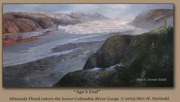
2 Introduction thousand years ago during the last ice age Image courtesy gis4geomorphology.com

3 Introduction These glaciers: Were up to 100 s of meters thick Would occasionally block freeflowing rivers. Image courtesy pbs.org


4 Introduction Glacier blocked the natural outlet for the Clark Fork River With no alternative outlet, the glacial lake rose until it filled to a level that caused the ice dam to break. Glacial Lake Missoula Image courtesy sandpointonline.com, Illustration by Bruce Bjornstad.
 Surface Area = 2900 sq. miles, 7500 km 2 Volume = 500 miles 3, 2084 km 3, 1.")

5 Introduction Glacial Lake Missoula Stats About 1,970 ft deep at the ice dam (Same as Crater Lake) Surface Area = 2900 sq. miles, 7500 km 2 Volume = 500 miles 3, 2084 km 3, 1.7 Billion acre-ft. About half of Lake Michigan, or equivalent to Lake Erie and Lake Ontario combined. About 290 meters deep at Missoula, MT Image courtesy hugefloods.com Image courtesy sites.coloradocollege.edu

6 Solving the Mystery J Harlen Bretz Geologist from University of Chicago Wondered about the many odd and large scale geologic features of Eastern Washington-Scablands. In 1923, he proposed a Catastrophic Flood was responsible. HERETIC! Uniformitarianism was the theory du jour in the geologic community and there was no room for the backwards thinking of Catastrophists. Not until 1965 did the geologic community as a whole embrace Bretz s theories. In 1979, at the age of 96, Bretz was awarded the Penrose Medal. What did he see that drew his attention?

 350 ft drop!")

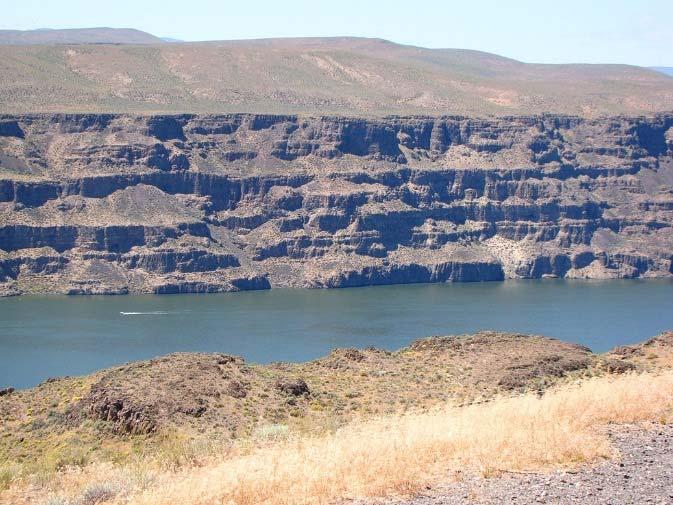
7 Solving the Mystery Dry Falls Image courtesy tau0.wordpress.com 3 miles wide (5 times wider than Niagara) 350 ft drop! (> 2 times higher than Niagara) > 10 times the volume of all the rivers in the world combined.


8 Solving the Mystery Giant Ripples West Bar Washington Google Earth 50 ft high with wavelengths of 500 ft hugefloods.com


9 Solving the Mystery Giant Ripples Markle Pass and Camas Prairie, MT Google Earth Camas Prairie, MT, hugefloods.com


10 Solving the Mystery Giant Ripples???


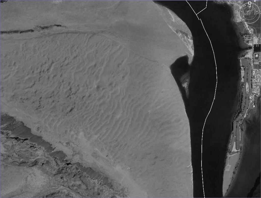
11 Solving the Mystery Columbia River Gorge


12 Solving the Mystery Rocky Butte


13 Solving the Mystery Lake Oswego


14 Solving the Mystery Ice Rafted Erratics BruceBjornstad.com HugeFloods.com BruceBjornstad.com


15 Solving the Mystery Erratics Yeager Rock, Mansfield, WA


16 Solving the Mystery Erratics Badger Coulee Vineyard


17 Solving the Mystery Erratics


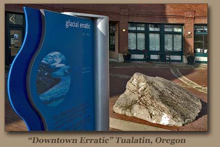
18 Bellevue Erratic
")
19 Hydraulic Modeling of the Missoula Floods Dam Breach Modeling Important component in dam safety programs Has been applied to modern-day glacial lake outbursts (Himalayas) Jokulhlaups
20 Modeling Approach HEC-RAS One-Dimensional unsteady flow model. Has Dam Breach capability Has many built-in stabilizing techniques But can it handle this?

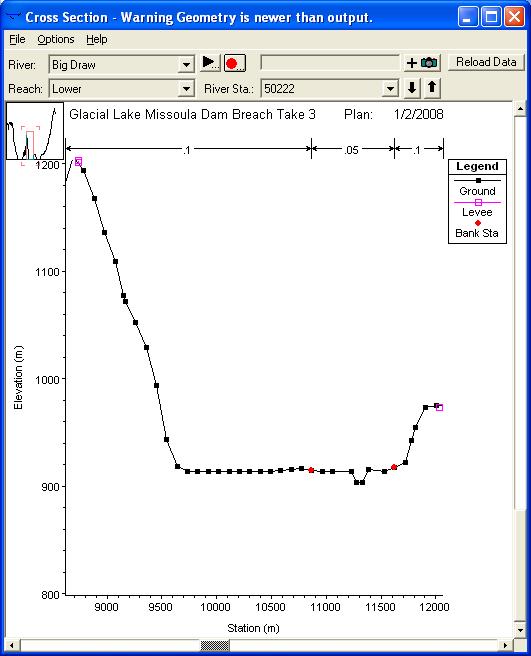
21 Modeling Approach Terrain Model 1 o DEM from USGS EROS site, scale 1:250k Vertical Resolution 30 meters, Horizontal Resolution ~ 130 meters Converted to an ESRI Grid

22 Modeling Approach Flow Path Approximation 1-D model Not as difficult as first thought! Aerial Photos and DEM s

23 Modeling Approach Initial Spacing about 5 km 2,346 Cross Sections 68 Reaches 34 Junctions 36 External Boundaries

24 Modeling Approach Inline and Lateral Structures

25 Modeling Approach Flow Data Constant Inflow Hydrographs (Sunny Day Event) Inflow Values approximated by USGS stream gage data (when available) Precise initial conditions not necessary Flood wave 100 times greater than all streams combined. Downstream Boundary: Normal Depth. Applied upstream of the Mouth of the Columbia.


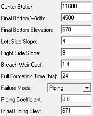
26 Model Development/Assumptions Defining the Breach Piping hr development Breach width??? Hubbard Glacier Jokulhlaup

27 Model Development/Assumptions Numerical Stability 2000 m Blind Interpolation Down to 500 m in some areas 30 second time step (Courant Condition)

28 Model Development/Assumptions Channel Modification Pilot Channels Channel Modification Tool
29 Model Development/Assumptions Hotstart Flow Distributions, Junctions & Lateral Structures Step-Down Scheme

30 Model Development/Assumptions Sediment Transport Undoubtedly a LOT of sediment movement occurred. Wind-blown silt thought to accumulate to depths of several hundred feet in the Eastern Washington Scablands prior to the Missoula Floods Where did the silt go? How did it affect the flooding? How does this affect the modeling effort?
31 Model Development/Assumptions Advance/Retreat of Glaciers Flood Morphology Now thought that each flood event carved a different and new path on its way to the Columbia River Gorge.

32 Model Development/Assumptions Research suggests Grand Coulee-Moses Coulee Floods Telford-Crab Creek Floods Cheney-Palouse Floods This modeling effort attempts to capture the LAST of the Missoula Flood Events
33 Results From Geologic Record: Maximum Lake Missoula Elevation = 4,200 ft 386 million cfs peak (50 Amazon Rivers or 10 times all the rivers in the world combined!) 30 to 50 mph velocities separate Missoula Floods Flood waters reached as far upstream the Willamette Valley as Eugene, OR.
34 Results From the HEC-RAS output: Breach initiation to Pacific Ocean: 48 hours. Peak Discharge at Breach: 141 million cfs 6 days to drain Glacial Lake Missoula. Peak Discharge at Ocean: 32.6 million cfs. 4 days to fill up the Willamette Valley, 14 days to drain. Floodwater traveled 120 miles UP the Snake River, 70 miles UP the Yakima River. Up to 980 ft inundation depths in Glacial Lake Columbia, 690 ft below Dry Falls. 200 ft inundation in Downtown Portland.
35 Results From the HEC-RAS output: Velocities around 65 ft/s found at Wallula Gap, 26 ft/s through the Columbia River Gorge. Flood Depths in the Gorge up to 380 ft. Geologists estimate the maximum to be 980 ft.
36 Results Flow Hydrographs 5.00E+06 Discharge (m 3 /s) 4.00E E E E million cfs Ice Dam Breach 32.6 million cfs Mouth of Columbia 0.00E Days

37 Results

38 Results My HEC-RAS Model Results

39 Results
40 Results Wilson, Lake, and Rock Creek Coulees did not flood in modelgeologic evidence suggests otherwise. This prevented Upper, Middle, and Lower Crab Creek, and Lind Coulees from flooding. Again, geologic evidence suggests otherwise. Shorter breach development times produced slightly higher peak discharges, but not enough to flood the higher elevation coulees. Other knobs: Manning s n values, discharge coefficients, etc. Must be a geomorphic explanation to the differences.
41 Results Wilson Lake Rock Cheney Palouse Floods 41
42 Conclusions HEC-RAS can model an event like the Glacial Lake Missoula Floods This Simulation probably better represented the last of the many Glacial Lake Missoula Floods Much more research into pre-flood sediment deposits/characteristics to run a sediment transport dam breach model


43 THANK YOU Alt, David. Glacial Lake Missoula and Its Humongous Floods, Mountain Press Publishing, Missoula, MT, Allen, John Elliot; Burns, Marjorie, Cataclysms on the Columbia, Timber Press, Portland, OR, Great Overall Resource online collection of erratics.
The Example of the Lake Missoula Flood
 Chapter 85 The Example of the Lake Missoula Flood As already noted, uniformitarian hypotheses rarely, if ever, can be supported by extensive geological evidence. Part of this is due to the nature of the
One of the tasks of the Floods Study Team was to determine if any new facilities
 8. Development and Enhancement of Interpretive Facilities One of the tasks of the Floods Study Team was to determine if any new facilities would be needed to help interpret the Floods story, or if any
Sculpted by Floods Learning Resource Guide
 Sculpted by Floods Learning Resource Guide Overview: KSPS s Sculpted by Floods tells the story of the ice age floods in the Pacific Northwest. It is a story of the earth's power, scientific discovery and
EXTENSION MODULE A. Introduction. B. Dynamics of Glacial Lakes
 EXTENSION MODULE 18.1 Humongous Ice-Age Floods in the Pacific Northwest This module describes the unusual landscape features produced by dozens of humongous-discharge floods that crossed the Pacific Northwest
Columbia River Gorge Near Perfection... And Only 40+ Million Years in the Making
 Columbia Gorge Geology and the Ice Age Floods Columbia River Gorge Near Perfection... And Only 40+ Million Years in the Making Lloyd DeKay, Ice Age Floods Institute - Columbia Gorge Chapter GorgeFloods.org
THE MISSOULA FLOOD OVERVIEW
 THE MISSOULA FLOOD Dry Falls in Grand Coulee, Washington, is the largest waterfall in the world, but it is currently inactive because it is on an intermittent stream that is not expected to flow again
Mystery of the Megaflood
 Mystery of the Megaflood Program Overview NOVA presents the story of the greatest flood ever found in the geologic record and the geologist who went against prevaiing theories to explain that the flood
Cattaraugus Creek: A Story of Flowing Water and the Geology of the Channel It Flows Through Presentation to West Valley Citizen Task Force 4/27/16
 Cattaraugus Creek: A Story of Flowing Water and the Geology of the Channel It Flows Through Presentation to West Valley Citizen Task Force 4/27/16 Raymond C. Vaughan, Ph.D. What happens if you drop a
Channelized Flood Flow Cuts Water and Wind Gaps
 Chapter 84 Channelized Flood Flow Cuts Water and Wind Gaps The vast majority of water and wind gaps, especially the deep ones, provide powerful evidence for the Channelized Flow Phase of the Flood. It
Assessment of the Hood River Delta Hood River, Oregon
 Assessment of the Hood River Delta Hood River, Oregon Pacific Northwest Waterways Association Annual Meeting October 13, 2010 Michael McElwee, Executive Director Port of Hood River Overview U.S. Army Corps
mountain rivers fixed channel boundaries (bedrock banks and bed) high transport capacity low storage input output
 high transport capacity low storage input output") mountain rivers fixed channel boundaries (bedrock banks and bed) high transport capacity low storage input output strong interaction between streams & hillslopes Sediment Budgets for Mountain Rivers Little
mountain rivers fixed channel boundaries (bedrock banks and bed) high transport capacity low storage input output strong interaction between streams & hillslopes Sediment Budgets for Mountain Rivers Little
Science EOG Review: Landforms
 Mathematician Science EOG Review: Landforms Vocabulary Definition Term canyon deep, large, V- shaped valley formed by a river over millions of years of erosion; sometimes called gorges (example: Linville
Lecture Outline Lecture Outline Monday April 9-16, 2018 Questions? Announcements:
 Lecture Outline Lecture Outline Monday April 9-16, 2018 Questions? Announcements: Geology 101 Night Video: The Day After Tomorrow Hollywood disaster movie about the onset of a glacial period When: Monday
Gravel Transport Can Determine Late Flood Tectonics
 Chapter 23 Gravel Transport Can Determine Late Flood Tectonics The locations of all the quartzite gravel in the northwest states and adjacent Canada provide more information about the Flood than just reinforcing
Vantage/Columbia Basin Field Trip
 Geology 152 Name Vantage/Columbia Basin Field Trip The primary goal of this course is to help you see the Earth from a different perspective a geological one. To accomplish this goal you will be expected
LOMR SUBMITTAL LOWER NESTUCCA RIVER TILLAMOOK COUNTY, OREGON
 LOMR SUBMITTAL LOWER NESTUCCA RIVER TILLAMOOK COUNTY, OREGON Prepared for: TILLAMOOK COUNTY DEPARTMENT OF COMMUNITY DEVELOPMENT 1510-B THIRD STREET TILLAMOOK, OR 97141 Prepared by: 10300 SW GREENBURG ROAD,
Pacific Northwest Quaternary Climate History: Very Short Version 2:00
 Pacific Northwest Quaternary Climate History: Very Short Version 2:00 Glacial Maximum North America Major Effects: 1. Great Lakes 2. Missouri River Drainage 3. Upper Mississippi River Drainage 3. Ohio
LOMR SUBMITTAL LOWER NEHALEM RIVER TILLAMOOK COUNTY, OREGON
 LOMR SUBMITTAL LOWER NEHALEM RIVER TILLAMOOK COUNTY, OREGON Prepared for: TILLAMOOK COUNTY DEPARTMENT OF COMMUNITY DEVELOPMENT 1510-B THIRD STREET TILLAMOOK, OR 97141 Prepared by: 10300 SW GREENBURG ROAD,
COLUMBIA THE MAGAZINE OF NORTHWEST HISTORY SPRING 2005 $7.50
 COLUMBIA THE MAGAZINE OF NORTHWEST HISTORY SPRING 2005 $7.50 The canoes of Lewis ana Clark on the Columbia River WASHINGTON STATE HISTORICAL SOCIETY The Great in Washington, sits a little park near the
THE GEOLOGY OF SCULPTING STONE COLUMBIA RIVER BASALT
 THE GEOLOGY OF SCULPTING STONE COLUMBIA RIVER BASALT 1 Michael E. Yeaman OUTLINE The Stone Defined General Description, Physical/Chemical Properties and Historic Use Specimens (macro and thin section)
Title: A case for repeated outburst floods for the creation of the Channeled Scablands:
 Channeled scablands: observations and interpretations 1 Title: A case for repeated outburst floods for the creation of the Channeled Scablands: Observations and interpretations Author: Kerry J. Cupit Location:
What are the different ways rocks can be weathered?
 Romano - 223 What are the different ways rocks can be weathered? Weathering - the breakdown of rocks and minerals at the Earth s surface 1. 2. PHYSICAL WEATHERING Rock is broken into smaller pieces with
UPPER COSUMNES RIVER FLOOD MAPPING
 UPPER COSUMNES RIVER FLOOD MAPPING DRAFT BASIC DATA NARRATIVE FLOOD INSURANCE STUDY SACRAMENTO COUTY, CALIFORNIA Community No. 060262 November 2008 Prepared By: CIVIL ENGINEERING SOLUTIONS, INC. 1325 Howe
Waterbury Dam Disturbance Mike Fitzgerald Devin Rowland
 Waterbury Dam Disturbance Mike Fitzgerald Devin Rowland Abstract The Waterbury Dam was completed in October 1938 as a method of flood control in the Winooski Valley. The construction began in April1935
What Happened. to Our. Earth?
 What Happened to Our Earth? What Happened to Our Earth? EVIDENCE FOR A RECENT GLOBAL FLOOD AND ICE AGE a sermon by Norman Moll, April 16, 2011 What caused the Global Flood? Genesis 6:5 8 The LORD saw how
The Tualatin a n d Yamhill Valleys In Northwest Oregon
 The Tualatin a n d Yamhill Valleys In Northwest Oregon by Rick Thompson As the largest of the Lake Missoula Floods burst out of the Columbia River Gorge, it filled up the Portland basin and spilled out
Stop 1: Marmot Dam Stop 1: Marmot Dam
 Stop 1: Marmot Dam Stop 1: Marmot Dam Following the removal of Marmot Dam in 2007, the fate of the reservoir sediments has been monitored through a series of surveys and sediment transport measurements.
Weathering, Erosion, Deposition, and Landscape Development
 Weathering, Erosion, Deposition, and Landscape Development I. Weathering - the breakdown of rocks into smaller particles, also called sediments, by natural processes. Weathering is further divided into
Released Science Inquiry Task Encounter with an Active Volcano Grade 11
 Date: Your Name: Released Science Inquiry Task Encounter with an Active Volcano 2016 Grade 11 Directions: Science You will be reading a story and analyzing the data provided to answer a set of questions.
ES 105 Surface Processes I. Hydrologic cycle A. Distribution % in oceans 2. >3% surface water a. +99% surface water in glaciers b.
 ES 105 Surface Processes I. Hydrologic cycle A. Distribution 1. +97% in oceans 2. >3% surface water a. +99% surface water in glaciers b. >1/3% liquid, fresh water in streams and lakes~1/10,000 of water
9. PROBABLE MAXIMUM PRECIPITATION AND PROBABLE MAXIMUM FLOOD
 9. PROBABLE MAXIMUM PRECIPITATION AND PROBABLE MAXIMUM FLOOD 9.1. Introduction Due to the size of Watana Dam and the economic importance of the Project to the Railbelt, the Probable Maximum Flood (PMF)
STREAM SYSTEMS and FLOODS
 STREAM SYSTEMS and FLOODS The Hydrologic Cycle Precipitation Evaporation Infiltration Runoff Transpiration Earth s Water and the Hydrologic Cycle The Hydrologic Cycle The Hydrologic Cycle Oceans not filling
Precipitation Evaporation Infiltration Earth s Water and the Hydrologic Cycle. Runoff Transpiration
 STREAM SYSTEMS and FLOODS The Hydrologic Cycle Precipitation Evaporation Infiltration Earth s Water and the Hydrologic Cycle Runoff Transpiration The Hydrologic Cycle The Hydrologic Cycle Oceans not filling
Riverine Modeling Proof of Concept
 Technical Team Meeting Riverine Modeling Proof of Concept Version 2 HEC-RAS Open-water Flow Routing Model April 15-17, 2014 Prepared by R2 Resource Consultants, Brailey Hydrologic, Geovera, Tetra Tech,
Name: Mid-Year Review #2 SAR
 Name: Mid-Year Review #2 SAR Base your answers to questions 1 through 3 on on the diagram below, which shows laboratory materials used for an investigation of the effects of sediment size on permeability,
Geologic Evolution of the Skagit River Channel Migration Zone. J. Riedel National Park Service
 Geologic Evolution of the Skagit River Channel Migration Zone J. Riedel National Park Service LSWT BT OT CMZ defined by: 1) Areas within FEMA floodplain of Skagit River (100 and 500 year); 2) Areas within
Technical Memorandum No Sediment Model
 Pajaro River Watershed Study in association with Technical Memorandum No. 1.2.9 Sediment Model Task: Development of Sediment Model To: PRWFPA Staff Working Group Prepared by: Gregory Morris and Elsie Parrilla
Pompton Lakes Dam Downstream Effects of the Floodgate Facility. Joseph Ruggeri Brian Cahill Michael Mak Andy Bonner
 Pompton Lakes Dam Downstream Effects of the Joseph Ruggeri Brian Cahill Michael Mak Andy Bonner ASFPM 2013: Overview Page 2 Overview Page 3 Overview Page 4 Overview Page 5 Overview - Historical Pompton
Glacial Lake Missoula
 120 Hickory Street, Suite A Missoula, MT 59801 406-327-0405 Glacial Lake Missoula Nature Discovery Trunk Curriculum Glacial Lake Missoula Trunk Nature Discovery Trunk Contents List Articles, Books & Pamphlets:
Groundwater-Surface Water Interactions along the Hangman, California, and Rock Creeks, September 30, 2009
 Groundwater-Surface Water Interactions along the Hangman, California, and Rock Creeks, September 30, 2009 Abstract This data collection effort was required to complete recommendations in the Hangman Creek
Module/Unit: Landforms Grade Level: Fifth
 Module/Unit: Landforms Grade Level: Fifth PA Academic Standards for Science and Technology and Environment and Ecology: 3.1.7.B Describe the use of models as an application or scientific or technological
Name. 4. The diagram below shows a soil profile formed in an area of granite bedrock. Four different soil horizons, A, B, C, and D, are shown.
 Name 1. In the cross section of the hill shown below, which rock units are probably most resistant to weathering? 4. The diagram below shows a soil profile formed in an area of granite bedrock. Four different
By Gil Brenner OLLI Geology Of New York State and NY City
 By Gil Brenner OLLI 2013 Geology Of New York State and NY City Before We Start-- It s All in the PLATES! Geology of New York State including NYC CA. Active Margin A Passive Geologic Margin Gil Brenner
Channeled scablands of eastern Washington: the geologic story of the Spokane flood
 Eastern Washington University EWU Digital Commons Publications from Special Collections University Archives & Special Collections 1989 Channeled scablands of eastern Washington: the geologic story of the
CR AAO Bridge. Dead River Flood & Natural Channel Design. Mitch Koetje Water Resources Division UP District
 CR AAO Bridge Dead River Flood & Natural Channel Design Mitch Koetje Water Resources Division UP District Old County Road AAO Bridge Map courtesy of Marquette County Silver Lake Basin McClure Basin
Chapter 4 Hydrodynamic Modelling of Glacial Lake Outburst Floods
 Chapter 4 Hydrodynamic Modelling of Glacial Lake Outburst Floods To better understand the impacts that a GLOF can have on the downstream valleys, an attempt was made to simulate one GLOF event each in
Mountain Rivers. Gutta cavat lapidem. (Dripping water hollows out a stone) -Ovid, Epistulae Ex Ponto, Book 3, no. 10, 1. 5
 -Ovid, Epistulae Ex Ponto, Book 3, no. 10, 1. 5") Mountain Rivers Gutta cavat lapidem (Dripping water hollows out a stone) -Ovid, Epistulae Ex Ponto, Book 3, no. 10, 1. 5 Mountain Rivers Fixed channel boundaries (bedrock banks and bed) High transport
Mountain Rivers Gutta cavat lapidem (Dripping water hollows out a stone) -Ovid, Epistulae Ex Ponto, Book 3, no. 10, 1. 5 Mountain Rivers Fixed channel boundaries (bedrock banks and bed) High transport
Chapter 3 Erosion in the Las Vegas Wash
 Chapter 3 Erosion in the Las Vegas Wash Introduction As described in Chapter 1, the Las Vegas Wash (Wash) has experienced considerable change as a result of development of the Las Vegas Valley (Valley).
Bushkill Creek 3 rd Street Dam Removal Analysis
 Bushkill Creek 3 rd Street Dam Removal Analysis HEC HMS Runoff and Routing Model Stephen Beavan, Melanie DeFazio, David Gold, Peter Mara and Dan Moran CE 421: Hydrology Fall 2010 December 15, 2010 Contents
APPENDIX A M&T/Llano Seco Long-Term Water Reliability Study These photos are examples of rock spurs in use throughout the United States
 APPENDIX A M&T/Llano Seco Long-Term Water Reliability Study These photos are examples of rock spurs in use throughout the United States Glenn Colusa Irrigation District completed a Sacramento River project
Erratic Behavior on Rattlesnake Mountain, Hanford Reach National Monument, South-Central Washington
 Erratic Behavior on Rattlesnake Mountain, Hanford Reach National Monument, South-Central Washington Bruce Bjornstad, Pacific Northwest National Laboratory Elysia Jennett, Northern Arizona University Jenna
 Page 1 of 9 Name: Base your answer to the question on the diagram below. The arrows show the direction in which sediment is being transported along the shoreline. A barrier beach has formed, creating a
Lecture 14: Floods. Key Questions
 Lecture 14: Floods Key Questions 1. What is an upstream flood? 2. What is a downstream flood? 3. What were the setup conditions that cause floods? 4. What is a 100-year flood? 5. How are 100-year flood
Tom Ballestero University of New Hampshire. 1 May 2013
 Tom Ballestero University of New Hampshire 1 May 2013 1 Hydrology 2 Basic Hydrology Low flows most common Flows that fill the stream to the banks and higher are much less common Filling the stream to the
Technical Memorandum No
 Pajaro River Watershed Study in association with Technical Memorandum No. 1.2.10 Task: Evaluation of Four Watershed Conditions - Sediment To: PRWFPA Staff Working Group Prepared by: Gregory Morris and
STREAM RESTORATION AWRA Summer Specialty Conference, GIS and Water Resources IX
 STREAM RESTORATION 2016 AWRA Summer Specialty Conference, GIS and Water Resources IX Innovative Use of 2D Hydraulic Modeling in Stream Restoration Design Presented by: Li Gao, PE and Robert Scrafford,
Laboratory Exercise #3 The Hydrologic Cycle and Running Water Processes
 Laboratory Exercise #3 The Hydrologic Cycle and Running Water Processes page - 1 Section A - The Hydrologic Cycle Figure 1 illustrates the hydrologic cycle which quantifies how water is cycled throughout
Changes to Land 5.7B. landforms: features on the surface of Earth such as mountains, hills, dunes, oceans and rivers
 All the landforms on Earth have changed over time and continue to change. Many of the changes were caused by wind, moving water, and moving ice. Mountains have grown and shrunk. Rivers have cut away land
SPQ Module 20 Ice Flows
 SPQ Module 20 Ice Flows When Ray, Richard & Kevin received their sleds in Southern Chili they opened them with excitement, and Kevin remarked they look like little canoes. It is perhaps appropriate that
Think about the landforms where you live. How do you think they have changed over time? How do you think they will change in the future?
 reflect All the landforms on Earth have changed over time and continue to change. Many of the changes were caused by wind, moving water, and moving ice. Mountains have grown and shrunk. Rivers have cut
Chapter 12: River Systems and Landforms
 Chapter 12: River Systems and Landforms Base Levels: Local and Ultimate Figure 12.6 Figure 12.2 A Drainage Basin Rills and Gullies feeding into small Streams in Iowa North American Drainage Basins Figure
Unconventional Wisdom and the Effects of Dams on Downstream Coarse Sediment Supply. Byron Amerson, Jay Stallman, John Wooster, and Derek Booth
 Unconventional Wisdom and the Effects of Dams on Downstream Coarse Sediment Supply 3 February 2009 Byron Amerson, Jay Stallman, John Wooster, and Derek Booth Sultan River, WA OBJECTIVE Consider the landscape
The Little Colorado River
 The Little Colorado River The Little Colorado River Junction of the Little Colorado River and the Colorado Grand Falls of the Little Colorado River The relief/topo map at the right shows the junction of
To: Olivia Dorothy March 9, 2018 Associate Director Upper Mississippi River Basin American Rivers
 To: Olivia Dorothy March 9, 2018 Associate Director Upper Mississippi River Basin American Rivers From: Jonathan W.F. Remo Ph.D. Big Muddy Consulting Re: Assessment of flood surcharge related to differences
Ways To Identify Background Verses Accelerated Erosion
 Ways To Identify Background Verses Accelerated Erosion Establish Background Condition From Old Ground Photos, Aerial Photos, and Maps Compare Rate Over Time At the Same Location, or for Reaches Channel
1. Base your answer to the following question on the map below, which shows the generalized bedrock of a part of western New York State.
 1. Base your answer to the following question on the map below, which shows the generalized bedrock of a part of western New York State. 3. The table below describes the deposits that an observer saw while
UNSTOPPABLE COLLAPSE OF THE WEST ANTARCTIC ICE SHEET IS NOT HAPPENING
 UNSTOPPABLE COLLAPSE OF THE WEST ANTARCTIC ICE SHEET IS NOT HAPPENING Dr. Don J. Easterbrook, Western Washington University, Bellingham, WA May 19, 2014 A New York Times headline reads Scientists Warn
Figure 1. Map of Feather River Basin in northern California. (A) Region straddles the northwestern Sierra Nevada and Sacramento Valley.
 Region straddles the northwestern Sierra Nevada and Sacramento Valley.") Figure 1. Map of Feather River Basin in northern California. (A) Region straddles the northwestern Sierra Nevada and Sacramento Valley. (B) Feather River Basin with Yuba and Bear subbasins. Most hydraulic
Figure 1. Map of Feather River Basin in northern California. (A) Region straddles the northwestern Sierra Nevada and Sacramento Valley. (B) Feather River Basin with Yuba and Bear subbasins. Most hydraulic
Soils, Hydrogeology, and Aquifer Properties. Philip B. Bedient 2006 Rice University
 Soils, Hydrogeology, and Aquifer Properties Philip B. Bedient 2006 Rice University Charbeneau, 2000. Basin Hydrologic Cycle Global Water Supply Distribution 3% of earth s water is fresh - 97% oceans 1%
True or False: The Earth s surface has stayed the same for thousands of years
 True or False: The Earth s surface has stayed the same for thousands of years True or False: The Earth s surface has stayed the same for thousands of years The Earth s surface is always changing! Weathering
STAAR Science Tutorial 40 TEK 8.9C: Topographic Maps & Erosional Landforms
 Name: Teacher: Pd. Date: STAAR Science Tutorial 40 TEK 8.9C: Topographic Maps & Erosional Landforms TEK 8.9C: Interpret topographic maps and satellite views to identify land and erosional features and
Leveraging new models and data to improve flood stage forecast. Improving Flood Stage Forecasting in the Feather River Watershed. September 11 th 2015
 Leveraging new models and data to improve flood stage forecast Improving Flood Stage Forecasting in the Feather River Watershed September 11 th 2015 Mitch Russo, P.E. (DWR) Ashok Bathulla, P.E., CFM (GEI)
1 INTRODUCTION AND MAJOR FINDINGS... 1
 Memorandum To: Lindsey Clark, Stillwater Valley Watershed Council Coordinator From: Chad Raisland, Pioneer Technical Services, Inc. and Karin Boyd, Applied Geomorphology, Inc. CC: Tanya Lester, Stillwater
Glacial Deposition and Groundwater in Dutchess County
 Glacial Deposition and Groundwater in Dutchess County Name: Period: Thousands of years ago an enormous ice sheet blanketed the Hudson Valley in what was called the Wisconsinan Glaciation. The ice reshaped
Subsurface Geology of the Kennebec River
 Maine Geologic Facts and Localities July, 1998 Subsurface Geology of the Kennebec River 43 54 40.75 N, 69 48 29.01 W Text by Daniel B. Locke, Department of Agriculture, Conservation & Forestry 1 Map by
Aerial Views of Lakes. Michael Collier, Image Source: Earth Science World Image Bank
 Lakes Water Aerial Views of Lakes Michael Collier, Image Source: Earth Science World Image Bank Lake at Sunset Michael Collier, Image Source: Earth Science World Image Bank Great Salt Lake Marcus Milling,
St. David's Buried Gorge
 1/7 cliffs Left: south Niagara of Whirlpool River just in autumn; north of the Bottom Whirlpool Right:inWhirlpool autumn; and Top up Right: the Niagara Gorge River in autumn Photo Gallery {igallery 0}
High Impact Forces of Nature Hazards in and Around Rocky Mountain National Park
 Stop 1 High Impact Forces of Nature Hazards in and Around Rocky Mountain National Park Trip Leader Vince Matthews, Colorado Geological Survey RMAG on the Rocks July 28, 2007 Welcome to the July RMAG on
W he natural resources of Adams
 Above: Houghton Rock, Town of Adams. Following Page: "The Hole in the Rock" on Rattlesnake Mound--both remnants of rock formed by ancient seas hundreds of millions of year5 ago. (Courtesy, H.H. Bennett
 Red River Flooding June 2015 Caddo and Bossier Parishes Presented by: Flood Technical Committee Where the Rain Falls Matters I-30 versus I-20 I-20 Backwater and Tributary Floods (Localized) 2016 Flood
Evaluation and Incorporation of USACE HEC-RAS Model of Chicago Waterway System into the Development of the North Branch DWP
 M E M O R A N D U M Evaluation and Incorporation of USACE HEC-RAS Model of Chicago Waterway System into the Development of the North Branch DWP TO: FROM: Joseph Spradling, PE, HDR Steven Vassos, PE, FluidClarity
GEOL 1121 Earth Processes and Environments
 GEOL 1121 Earth Processes and Environments Wondwosen Seyoum Department of Geology University of Georgia e-mail: seyoum@uga.edu G/G Bldg., Rm. No. 122 Seyoum, 2015 Chapter 6 Streams and Flooding Seyoum,
Effects of input DEM data spatial resolution on Upstream Flood modeling result A case study in Willamette river downtown Portland
 Effects of input DEM data spatial resolution on Upstream Flood modeling result A case study in Willamette river downtown Portland By Hue Duong GEOG 593 Fall 2015 Digital Terrain Analysis Photo: Anh Duc
ACCUMULATED PRECIPITATION IN INCHES
 CUMULATIVE PRECIPITATION WATER YEAR 9 COLUMBIA BASIN ABOVE GRAND COULEE 87% of Normal 1971- Average ACCUMULATED PRECIPITATION IN INCHES 8 6 97% of Normal 94% of Normal 77% of Normal SNAKE RIVER BASIN ABOVE
COSMORPHOLOGY - May 2009
 Name COSMORPHOLOGY - May 2009 Geologic landforms Purpose: By studying aerial photographs you will learn to identify different kinds of geologic features based on their different morphologies and learn
Zone A Modeling (What Makes A Equal Approximate, Adequate, or Awesome)
") Zone A Modeling (What Makes A Equal Approximate, Adequate, or Awesome) ASFPM 2016 GRAND RAPIDS CONFERENCE Kevin Donnelly, P.E., GISP, PMP, CFM June 23, 2016 Agenda 1 Introduction 2 Flood Hazard Analysis
Zone A Modeling (What Makes A Equal Approximate, Adequate, or Awesome) ASFPM 2016 GRAND RAPIDS CONFERENCE Kevin Donnelly, P.E., GISP, PMP, CFM June 23, 2016 Agenda 1 Introduction 2 Flood Hazard Analysis
Mount St. Helens. Copyright 2010 LessonSnips
 Mount St. Helens Washington State is home to the Cascade Mountains, a range of mountains that extends from the Canadian province of British Columbia to northern California. Many of these mountains are
Day 3 Weathering and Erosion.notebook. October 02, Section 7.2. Erosion and Deposition. Objectives
 Objectives Describe the relationship of gravity to all agents of erosion. Contrast the features left from different types of erosion. Analyze the impact of living and nonliving things on the processes
EQ: Discuss main geographic landforms of the U.S. & Canada and examine varied landforms in relation to their lifestyles.
 EQ: Discuss main geographic landforms of the U.S. & Canada and examine varied landforms in relation to their lifestyles. Places & Terms for Discussion Appalachian Mountains Great Plains Canadian Shield
Field Observations and One-Dimensional Flow Modeling of Summit Creek in Mack Park, Smithfield, Utah
 Intermountain Center for River Rehabilitation and Restoration, Utah State University 31 July 2018 Field Observations and One-Dimensional Flow Modeling of Summit Creek in Mack Park, Smithfield, Utah I.
FAILURES IN THE AMAZON RIVERBANKS, IQUITOS, PERU
 FAILURES IN THE AMAZON RIVERBANKS, IQUITOS, PERU A.Carrillo-Gil University of Engineering & A.Carrillo Gil S.A.,Consulting Engineering,Lima,Peru L. Dominguez University of Engineering,Lima & The Maritime
The Niagara Escarpment extends from western New York, through the GTA all the way up to Manitoulin Island and into Michigan and Wisconsin.
 is southern Ontario s most prominent topographic feature, extending more than 500 kilometres from western New York, through Niagara Falls and the western part of the Greater Toronto Area (GTA), and north
APPENDIX 3B OCCURRENCE OF SIGNIFICANT RIVER ALLUVIUM AQUIFERS IN THE PLATEAU REGION
 Plateau Region Water Plan January 2011 APPENDIX 3B OCCURRENCE OF SIGNIFICANT RIVER ALLUVIUM AQUIFERS IN THE PLATEAU REGION Occurrence of Significant River Alluvium Aquifers in the Plateau Region Prepared
NRC Workshop Probabilistic Flood Hazard Assessment (PFHA) Jan 29-31, Mel Schaefer Ph.D. P.E. MGS Engineering Consultants, Inc.
 Jan 29-31, Mel Schaefer Ph.D. P.E. MGS Engineering Consultants, Inc.") Stochastic Event Flood Model (SEFM) Stochastic Modeling of Extreme Floods A Hydrological Tool for Analysis of Extreme Floods Mel Schaefer Ph.D. P.E. MGS Engineering Consultants, Inc. Olympia, WA NRC Workshop
Stochastic Event Flood Model (SEFM) Stochastic Modeling of Extreme Floods A Hydrological Tool for Analysis of Extreme Floods Mel Schaefer Ph.D. P.E. MGS Engineering Consultants, Inc. Olympia, WA NRC Workshop
Highland Lake Bathymetric Survey
 Highland Lake Bathymetric Survey Final Report, Prepared For: The Town of Highland Lake 612 Lakeshore Drive Oneonta, AL 35121 Prepared By: Tetra Tech 2110 Powers Ferry Road SE Suite 202 Atlanta, GA 30339
Landscape evolution. An Anthropic landscape is the landscape modified by humans for their activities and life
 Landforms Landscape evolution A Natural landscape is the original landscape that exists before it is acted upon by human culture. An Anthropic landscape is the landscape modified by humans for their activities
Frank McManamon Subject: Comments on Columbia Plateau paleogeography and paleoenvironment
 Draft Memorandum (O008paleo) August 10, 2000 From: To: Brooke Blades Frank McManamon Subject: Comments on Columbia Plateau paleogeography and paleoenvironment The following summaries, comments, and observations
CASE STUDY #9 - Brushy Fork Dam, Sugar Grove, West Virginia
 CASE STUDY #9 - Brushy Fork Dam, Sugar Grove, West Virginia Brushy Fork Dam is a flood control structure built by the Soil Conservation Service southeast of the city of Franklin in Pendleton County, West
USGS Flood Inundation Mapping of the Suncook River in Chichester, Epsom, Pembroke and Allenstown, New Hampshire
 USGS Flood Inundation Mapping of the Suncook River in Chichester, Epsom, Pembroke and Allenstown, New Hampshire NH Water & Watershed Conference Robert Flynn, USGS NH-VT Water Science Center March 23, 2012
EROSIONAL FEATURES. reflect
 reflect Have you ever looked at the land around you and wondered what processes shaped what you see? Perhaps you see mountains, valleys, rivers, or canyons. Do you know how long these geologic features