Chapter 12: River Systems and Landforms
|
|
|
- Roberta Wilkerson
- 5 years ago
- Views:
Transcription

1 Chapter 12: River Systems and Landforms

2 Base Levels: Local and Ultimate Figure 12.6

3 Figure 12.2 A Drainage Basin

4 Rills and Gullies feeding into small Streams in Iowa

5 North American Drainage Basins Figure 12.3


6 Rough outline of the Columbia River drainage basin

7 Landscape Drainage Patterns Treelike pattern Folded topography Volcanoes Steep slopes/relief Figure 12.5 Faulted & Jointed Structural domes No clear geometry

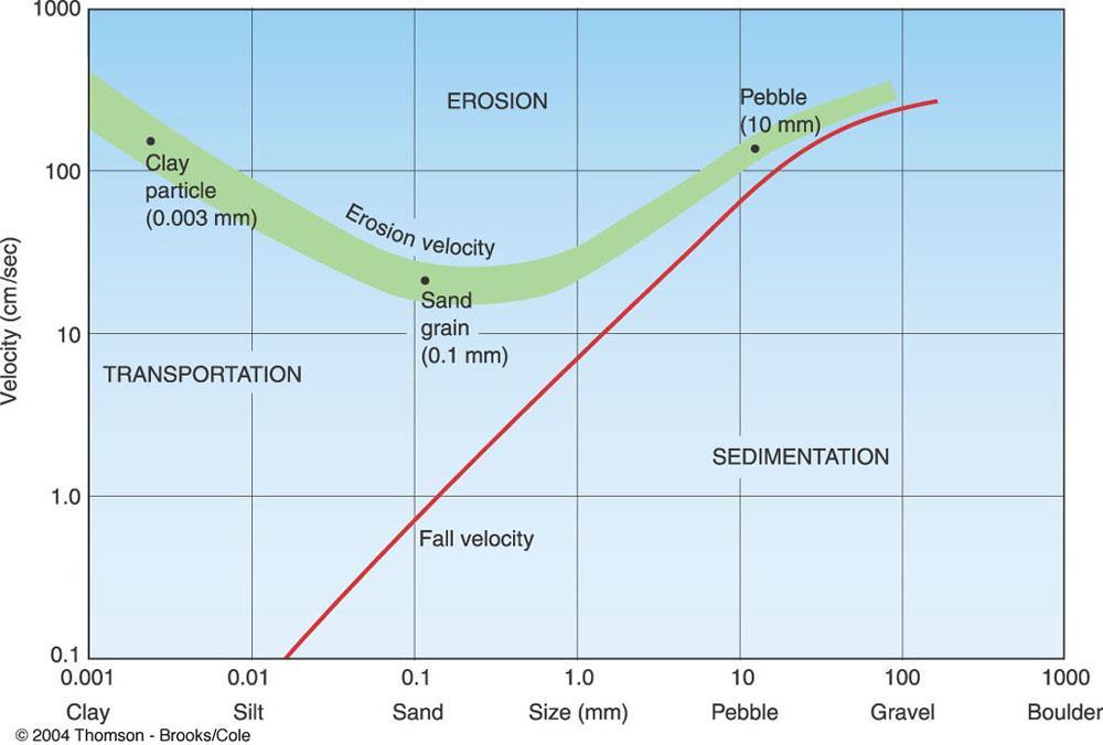
8 Figure Fluvial Transport
9

10 GIA 12: pp Meandering Stream Profile

11 Meandering Stream Development GIA 12: pp

12 Itkillik River, Alaska Cutoff GIA 12: pp

13 Athabasca River, Alberta

14 Horseshoe Bend: an entrenched meander along the Colorado River

15 Tasman River, New Zealand Braided stream channel

16 Figure Map of Carter Lake, Iowa

17 Rivers don t make good political boundaries, as indicated by the floodplain

18 Stream Longitudinal Profile: Graded Streams Greater erosion Greater deposition Figure 12.15

19 Development of a graded stream: progression to a local base level
20 Development of a graded stream: progression to a local base level

21 Development of a graded stream: progression to a local base level

22 Streams get wider, deeper, and faster as you move downslope from the headwater source regions then flatter in slope

23 Figure Nickpoint in Stream Channel

24 Niagara Falls: current location of the nickpoint

25 Palouse Falls

26 Tangle Falls, British Columbia

27 Figure Typical Floodplain Features

28 Sebaskachu River, Labrador


29 Alluvial Terraces of the Rakaia River, New Zealand Rejuvenation of the stream via regional uplift often creates these terraces, since the stream still downcuts and sidecuts Figure 12.21


30 12.24: Nile River Delta

31 12.23: Mouths of the Ganges

32 Rapaalven River, Sweden: river infilled an entire lake with its delta, creating a braided channel within this former glacial valley

33 Disaster Planning for Rivers: Weather Forecasting, Dams, Levees, Monitoring

34 Figure 12.9 Streamflow Measurement

35 Figure 12.8 Flooding: Urban vs. Natural Landscapes

36 Flooding Near McCall, April 2002

37 Pacific Northwest: Built by Volcanics, Sculpted by Floods, Winds, Ice

38 Glacial Dam: Moreno Glacier, Patagonia

39 Moreno Ice Dam Failure: Outburst Flood [jahkollops]


40 Glacial Lake Missoula: multiple lakes were created by the intermittent advance of ice sheets during the last Ice Age as the various ice dams failed, massive floods swept across northern Idaho and eastern Washington

41 On Highway 195 Outside Spokane: Missoula Flood Deposits

42 Notice how vegetation on left-hand slope protects, while exposed slope erodes...

43 Still along Highway 195, on the right as you approach Spokane

44 Glacial Lake Missoula s flood deposits are being reworked by fluvial processes, a perfectly natural [but undesirable] reality.

45 Coping with erosion: using a dike -like structure to armor the toe of the slope against stream erosion processes.

46 Lake Bonneville: massive, single flood that rechanneled the Snake River

47 View from ancient shoreline of Glacial Lake Bonneville

48 A little closer to Moscow at the confluence of Snake and Clearwater Rivers are the cities of Lewiston on the left, and Clarkston on the right. The arrow is roughly where Atlas Sand & Gravel is located the business is mining flood deposits from the Lake Bonneville flood about 14,500 years ago the Great Salt Lake is what is left of former Lake Bonneville

49 Atlas Sand & Gravel: some material doesn t need crushing

50 Meander cutoff Structure: little change Oxbow lake formation Shrinking lakes Reoccupying old channel Disappearing lakes

51 Walker River, Sierra Range
PHYSICAL GEOGRAPHY. By Brett Lucas
 PHYSICAL GEOGRAPHY By Brett Lucas FLUVIAL PROCESSES Fluvial Processes The Impact of Fluvial Processes on the Landscape Streams and Stream Systems Stream Channels Structural Relationships The Shaping and
Running Water Earth - Chapter 16 Stan Hatfield Southwestern Illinois College
 Running Water Earth - Chapter 16 Stan Hatfield Southwestern Illinois College Hydrologic Cycle The hydrologic cycle is a summary of the circulation of Earth s water supply. Processes involved in the hydrologic
Streams. Stream Water Flow
 CHAPTER 14 OUTLINE Streams: Transport to the Oceans Does not contain complete lecture notes. To be used to help organize lecture notes and home/test studies. Streams Streams are the major geological agents
Landscape Development
 Landscape Development Slopes Dominate Natural Landscapes Created by the interplay of tectonic and igneous activity and gradation Deformation and uplift Volcanic activity Agents of gradation Mass wasting
Erosion Surface Water. moving, transporting, and depositing sediment.
 + Erosion Surface Water moving, transporting, and depositing sediment. + Surface Water 2 Water from rainfall can hit Earth s surface and do a number of things: Slowly soak into the ground: Infiltration
Streams. Water. Hydrologic Cycle. Geol 104: Streams
 Streams Why study streams? Running water is the most important geologic agent in erosion, transportation and deposition of sediments. Water The unique physical and chemical properties of water make it
STREAM SYSTEMS and FLOODS
 STREAM SYSTEMS and FLOODS The Hydrologic Cycle Precipitation Evaporation Infiltration Runoff Transpiration Earth s Water and the Hydrologic Cycle The Hydrologic Cycle The Hydrologic Cycle Oceans not filling
Precipitation Evaporation Infiltration Earth s Water and the Hydrologic Cycle. Runoff Transpiration
 STREAM SYSTEMS and FLOODS The Hydrologic Cycle Precipitation Evaporation Infiltration Earth s Water and the Hydrologic Cycle Runoff Transpiration The Hydrologic Cycle The Hydrologic Cycle Oceans not filling
FLUVIAL PROCESSES 13 MARCH 2014
 FLUVIAL PROCESSES 13 MARCH 2014 In this lesson we: Lesson Description Look at river profiles, river grading, river rejuvenation as well as the identification, description and formation of fluvial landforms.
ES 105 Surface Processes I. Hydrologic cycle A. Distribution % in oceans 2. >3% surface water a. +99% surface water in glaciers b.
 ES 105 Surface Processes I. Hydrologic cycle A. Distribution 1. +97% in oceans 2. >3% surface water a. +99% surface water in glaciers b. >1/3% liquid, fresh water in streams and lakes~1/10,000 of water
GEOL 1121 Earth Processes and Environments
 GEOL 1121 Earth Processes and Environments Wondwosen Seyoum Department of Geology University of Georgia e-mail: seyoum@uga.edu G/G Bldg., Rm. No. 122 Seyoum, 2015 Chapter 6 Streams and Flooding Seyoum,
mountain rivers fixed channel boundaries (bedrock banks and bed) high transport capacity low storage input output
 high transport capacity low storage input output") mountain rivers fixed channel boundaries (bedrock banks and bed) high transport capacity low storage input output strong interaction between streams & hillslopes Sediment Budgets for Mountain Rivers Little
mountain rivers fixed channel boundaries (bedrock banks and bed) high transport capacity low storage input output strong interaction between streams & hillslopes Sediment Budgets for Mountain Rivers Little
11/12/2014. Running Water. Introduction. Water on Earth. The Hydrologic Cycle. Fluid Flow
 Introduction Mercury, Venus, Earth and Mars share a similar history, but Earth is the only terrestrial planet with abundant water! Mercury is too small and hot Venus has a runaway green house effect so
River Response. Sediment Water Wood. Confinement. Bank material. Channel morphology. Valley slope. Riparian vegetation.
 River Response River Response Sediment Water Wood Confinement Valley slope Channel morphology Bank material Flow obstructions Riparian vegetation climate catchment vegetation hydrological regime channel
Fresh Water: Streams, Lakes Groundwater & Wetlands
 Fresh Water:, Lakes Groundwater & Wetlands Oct 27 Glaciers and Ice Ages Chp 13 Nov 3 Deserts and Wind and EXAM #3 Slope hydrologic cycle P = precip I = precip intercepted by veg ET = evapotranspiration
Erosion and Deposition
 Erosion and Deposition Erosion Sediment natural forces move rock/soil from one place to another. gravity, water, wind, glaciers, waves are causes material moved by erosion Deposition when erosion lays
FLUVIAL LANDFORMS. Floodplains
 FLUVIAL LANDFORMS Floodplains fairly flat & continuous surface occupying much of a valley bottom normally underlain by unconsolidated sediments subject to periodic flooding (usually once every year or
Final Exam. Running Water Erosion and Deposition. Willamette Discharge. Running Water
 Final Exam Running Water Erosion and Deposition Earth Science Chapter 5 Pages 120-135 Scheduled for 8 AM, March 21, 2006 Bring A scantron form A calculator Your 3 x 5 paper card of formulas Review questions
Earth Science Chapter 9. Day 6 - Finish Capillary Action Lab - Quiz over Notes - Review Worksheets over Sections 9.2 and 9.3
 Earth Science Chapter 9 Day 1 Day 2 Day 3 Read Section 9.1 Surface Water Chapter 9 Term Sheet Notes over Section 9.1 Surface Water Section 9.1 Review Worksheets Quiz over Section 9.1 Notes Virtual Lab
Rivers and Landslides
 Rivers and Landslides Path of desire or path of least resistance? Desire Path: A term in landscape architecture used to describe a path that isn t designed but rather is worn casually away by people finding
River Systems. Physical Geography Lecture - GEOG B1. Accessible on:
 River Systems Physical Geography Lecture - GEOG B1 Accessible on: www.cherylnail.com Hydrology Hydrology is the scientific study of the movement, distribution, and properties of water on Earth (and other
Landscape evolution. An Anthropic landscape is the landscape modified by humans for their activities and life
 Landforms Landscape evolution A Natural landscape is the original landscape that exists before it is acted upon by human culture. An Anthropic landscape is the landscape modified by humans for their activities
RIVERS, GROUNDWATER, AND GLACIERS
 RIVERS, GROUNDWATER, AND GLACIERS Delta A fan-shaped deposit that forms when a river flows into a quiet or large body of water, such as a lake, an ocean, or an inland sea. Alluvial Fan A sloping triangle
4. The map below shows a meandering stream. Points A, B, C, and D represent locations along the stream bottom.
 1. Sediment is deposited as a river enters a lake because the A) velocity of the river decreases B) force of gravity decreases C) volume of water increases D) slope of the river increases 2. Which diagram
What do you need for a Marathon?
 What do you need for a Marathon? Water and a snack? What about just a normal day? 1 flush = 3.5 gallons 1 flush = 3.5 gallons 10 minute shower = 20 gal 1 flush = 3.5 gallons 10 minute shower = 20 gal Jeans
Surface Water Short Study Guide
 Name: Class: Date: Surface Water Short Study Guide Multiple Choice Identify the letter of the choice that best completes the statement or answers the question. 1. The three ways in which a stream carries
Summary. Streams and Drainage Systems
 Streams and Drainage Systems Summary Streams are part of the hydrologic cycle and the chief means by which water returns from the land to the sea. They help shape the Earth s surface and transport sediment
6.1 Water. The Water Cycle
 6.1 Water The Water Cycle Water constantly moves among the oceans, the atmosphere, the solid Earth, and the biosphere. This unending circulation of Earth s water supply is the water cycle. The Water Cycle
EXTERNAL LAND FORMING PROCESSES
 NAME SCHOOL INDEX NUMBER DATE EXTERNAL LAND FORMING PROCESSES WEATHERING 1 1998 Q 7 (a) (i) What is the difference between weathering and mass wasting (ii) List five processes involved in chemical weathering
1. Erosion by Running Water Most powerful cause of erosion
 I. Destructive Forces Notes: Destructive force: a process in which land is destroyed or changed such as weathering and erosion. All landforms are a result of a combination of constructive and destructive
Day 3 Weathering and Erosion.notebook. October 02, Section 7.2. Erosion and Deposition. Objectives
 Objectives Describe the relationship of gravity to all agents of erosion. Contrast the features left from different types of erosion. Analyze the impact of living and nonliving things on the processes
True or False: The Earth s surface has stayed the same for thousands of years
 True or False: The Earth s surface has stayed the same for thousands of years True or False: The Earth s surface has stayed the same for thousands of years The Earth s surface is always changing! Weathering
Continental Landscapes
 Continental Landscapes Landscape influenced by tectonics, climate & differential weathering Most landforms developed within the last 2 million years System moves toward an equilibrium Continental Landscapes
The Hydrologic Cycle STREAM SYSTEMS. Earth s Water and the Hydrologic Cycle. The Hydrologic Cycle. Hydrologic Cycle
 STREAM SYSTEMS Earth Science: Chapter 5 Reading pages 114-124 The Hydrologic Cycle Oceans not filling up Evaporation = precipitation System is balanced Earth s Water and the Hydrologic Cycle Earth s Water
Chapter 3 Erosion and Deposition. The Big Question:
 Chapter 3 Erosion and Deposition The Big Question: 1 Design a way to represent and describe the 4 types of mass movement. You may use pictures, diagrams, list, web, chart, etc 2 Chapter 3: Erosion and
Prentice Hall EARTH SCIENCE
 Prentice Hall EARTH SCIENCE Tarbuck Lutgens Running Water and Groundwater Running Water The Water Cycle Water constantly moves among the oceans, the atmosphere, the solid Earth, and the biosphere. This
What is weathering and how does it change Earth s surface? Answer the question using
 7 th Grade Lesson What is weathering and how does it change Earth s surface? Answer the question using the sentence frame. You have 4 minutes. Weathering is. This changes the Earth s surface because. 1
Lecture Outlines PowerPoint. Chapter 5 Earth Science 11e Tarbuck/Lutgens
 Lecture Outlines PowerPoint Chapter 5 Earth Science 11e Tarbuck/Lutgens 2006 Pearson Prentice Hall This work is protected by United States copyright laws and is provided solely for the use of instructors
Surface Process Hazards Unit 2: Landscape Feature Scavenger Hunt
 Surface Process Hazards Unit 2: Landscape Feature Scavenger Hunt Sarah Hall (College of the Atlantic) and Becca Walker (Mt. San Antonio College) The following pages each have a series of questions about
Surface Water and Stream Development
 Surface Water and Stream Development Surface Water The moment a raindrop falls to earth it begins its return to the sea. Once water reaches Earth s surface it may evaporate back into the atmosphere, soak
Erosion and Deposition
 CHAPTER 3 LESSON 2 Erosion and Deposition Landforms Shaped by Water and Wind Key Concepts What are the stages of stream development? How do water erosion and deposition change Earth s surface? How do wind
Running Water: The Geology of Streams and Floods Running Water Chapter 14
 Geology 800 Today Running Water: The Geology of Streams and Floods Running Water Chapter 14 Next Class Oceans and Coasts 15 Stream Flow Streams Ribbons of water that flow down channels. Runoff Water in
GEOL 407- Geomorphology Fall '10
 1. Definitions- define any 8 of the following (3 pts each) A. Karst- A term derived from the type section area of the former Yugoslavia which describes a landscape created by dissolution of the underlying
Rivers T. Perron
 1 Rivers T. Perron 12.001 After our discussions of large-scale topography, how we represent topography in maps, and how topography interacts with geologic structures, you should be frothing at the mouth
Science EOG Review: Landforms
 Mathematician Science EOG Review: Landforms Vocabulary Definition Term canyon deep, large, V- shaped valley formed by a river over millions of years of erosion; sometimes called gorges (example: Linville
Ch 10 Deposition Practice Questions
 1. Base your answer to the following question on the data table below. Six identical cylinders, A through F, were filled with equal volumes of sorted spherical particles. The data table shows the particle
Fluvial Systems Lab Environmental Geology Lab Dr. Johnson
 Fluvial Systems Lab Environmental Geology Lab Dr. Johnson *Introductory sections of this lab were adapted from Pidwirny, M. (2006). "Streamflow and Fluvial Processes". Fundamentals of Physical Geography,
Chapter 2. Wearing Down Landforms: Rivers and Ice. Physical Weathering
 Chapter 2 Wearing Down Landforms: Rivers and Ice Physical Weathering Weathering vs. Erosion Weathering is the breakdown of rock and minerals. Erosion is a two fold process that starts with 1) breakdown
Name. 4. The diagram below shows a soil profile formed in an area of granite bedrock. Four different soil horizons, A, B, C, and D, are shown.
 Name 1. In the cross section of the hill shown below, which rock units are probably most resistant to weathering? 4. The diagram below shows a soil profile formed in an area of granite bedrock. Four different
STUDY GUIDE FOR CONTENT MASTERY. Surface Water Movement
 Surface Water SECTION 9.1 Surface Water Movement In your textbook, read about surface water and the way in which it moves sediment. Complete each statement. 1. An excessive amount of water flowing downslope
Earth Science Chapter 6 Section 2 Review
 Name: Class: Date: Earth Science Chapter 6 Section Review Multiple Choice Identify the choice that best completes the statement or answers the question. 1. Most streams carry the largest part of their
Figure 1. Which part of the river is labelled in Figure 1? a) Mouth b) Source c) Lower course d) channel
 Mouth b) Source c) Lower course d) channel") Rivers 1. Study Figure 1 showing the long profile of a river Figure 1 A Which part of the river is labelled in Figure 1? a) Mouth b) Source c) Lower course d) channel (1 mark) 2. Complete the sentences
Rivers 1. Study Figure 1 showing the long profile of a river Figure 1 A Which part of the river is labelled in Figure 1? a) Mouth b) Source c) Lower course d) channel (1 mark) 2. Complete the sentences
27. Running Water I (p ; )
") 27. Running Water I (p. 424-436; 440-444) Hydrosphere How much of the Earth s surface is covered by water? Earth's water is collectively called the and is stored in a number of so-called as follows: 1.
27. Running Water I (p. 424-436; 440-444) Hydrosphere How much of the Earth s surface is covered by water? Earth's water is collectively called the and is stored in a number of so-called as follows: 1.
Lectures Hydrology & Fluvial Geomorphology. Gauley River Images. Ancients' (= Biblical) Model of Water (Hydrologic) Cycle
 Model of Water (Hydrologic) Cycle") Lectures 11-13 13 Hydrology & Fluvial Geomorphology Gauley River Images http://www.youtube.com/watch?v=eulmuyegtz4&feature=related Ancients' (= Biblical) Model of Water (Hydrologic) Cycle Stream Water
Lectures 11-13 13 Hydrology & Fluvial Geomorphology Gauley River Images http://www.youtube.com/watch?v=eulmuyegtz4&feature=related Ancients' (= Biblical) Model of Water (Hydrologic) Cycle Stream Water
Chapter 10. Running Water aka Rivers. BFRB Pages
 Chapter 10 Running Water aka Rivers BFRB Pages 101-116 Stream Erosion and Transportation Running water is all precipitation (rain, snow, etc) that falls on Earth and is pulled downhill by gravity. Running
NATURAL RIVER. Karima Attia Nile Research Institute
 NATURAL RIVER CHARACTERISTICS Karima Attia Nile Research Institute NATURAL RIVER DEFINITION NATURAL RIVER DEFINITION Is natural stream of water that flows in channels with ih more or less defined banks.
Weathering, Erosion, Deposition
 Weathering, Erosion, Deposition The breakdown of rocks at or near the Earth s Surface. Physical Chemical - The breakdown of rock into smaller pieces without chemical change. - Dominant in moist /cold conditions
Laboratory Exercise #3 The Hydrologic Cycle and Running Water Processes
 Laboratory Exercise #3 The Hydrologic Cycle and Running Water Processes page - 1 Section A - The Hydrologic Cycle Figure 1 illustrates the hydrologic cycle which quantifies how water is cycled throughout
Page 1. Name:
 Name: 1) Which event is the best example of erosion? dissolving of rock particles on a limestone gravestone by acid rain breaking apart of shale as a result of water freezing in a crack rolling of a pebble
1. The map below shows a meandering river. A A' is the location of a cross section. The arrows show the direction of the river flow.
 1. The map below shows a meandering river. A A' is the location of a cross section. The arrows show the direction of the river flow. Which cross section best represents the shape of the river bottom at
Section 5. Low-Gradient Streams. What Do You See? Think About It. Investigate. Learning Outcomes
 Chapter 4 Surface Processes Section 5 Low-Gradient Streams What Do You See? Learning Outcomes In this section, you will Use models and real-time streamflow data to understand the characteristics of lowgradient
Essential Questions. What is erosion? What is mass wasting?
 Erosion Essential Questions What is erosion? What is mass wasting? What is Erosion? Erosion The transportation of sediment from one area to another Caused mainly by running water but also caused by glaciers,
Mountain Rivers. Gutta cavat lapidem. (Dripping water hollows out a stone) -Ovid, Epistulae Ex Ponto, Book 3, no. 10, 1. 5
 -Ovid, Epistulae Ex Ponto, Book 3, no. 10, 1. 5") Mountain Rivers Gutta cavat lapidem (Dripping water hollows out a stone) -Ovid, Epistulae Ex Ponto, Book 3, no. 10, 1. 5 Mountain Rivers Fixed channel boundaries (bedrock banks and bed) High transport
Mountain Rivers Gutta cavat lapidem (Dripping water hollows out a stone) -Ovid, Epistulae Ex Ponto, Book 3, no. 10, 1. 5 Mountain Rivers Fixed channel boundaries (bedrock banks and bed) High transport
What we will cover. The Hydrologic Cycle. River systems. Floods. Groundwater. Caves and Karst Topography. Hot springs
 Fresh Water What we will cover The Hydrologic Cycle River systems Floods Groundwater Caves and Karst Topography Hot springs On a piece of paper, put these reservoirs of water in to order from largest to
What are the different ways rocks can be weathered?
 Romano - 223 What are the different ways rocks can be weathered? Weathering - the breakdown of rocks and minerals at the Earth s surface 1. 2. PHYSICAL WEATHERING Rock is broken into smaller pieces with
Four Mile Run Levee Corridor Stream Restoration
 Four Mile Run Levee Corridor Stream Restoration 30% Design Summary U.S. Army Corps of Engineers, Baltimore District Presentation Outline Four Mile Run 1.) Historic Perspective 2.) Existing Conditions 3.)
Pat Dryer Half Moon Lake: A True Oxbow Lake? Geography 364 April 1 st, 2007
 Pat Dryer Half Moon Lake: A True Oxbow Lake? Geography 364 April 1 st, 2007 Appendix Abstract 2 Introduction 3 Methods 3 Results 3 Discussion 5 Conclusion 11 1 Abstract Half Moon Lake appears to be an
STAAR Science Tutorial 40 TEK 8.9C: Topographic Maps & Erosional Landforms
 Name: Teacher: Pd. Date: STAAR Science Tutorial 40 TEK 8.9C: Topographic Maps & Erosional Landforms TEK 8.9C: Interpret topographic maps and satellite views to identify land and erosional features and
In the space provided, write the letter of the description that best matches the term or phrase. a. any form of water that falls to Earth s
 Skills Worksheet Concept Review In the space provided, write the letter of the description that best matches the term or phrase. 1. condensation 2. floodplain 3. watershed 4. tributary 5. evapotranspiration
EXTENSION MODULE A. Introduction. B. Dynamics of Glacial Lakes
 EXTENSION MODULE 18.1 Humongous Ice-Age Floods in the Pacific Northwest This module describes the unusual landscape features produced by dozens of humongous-discharge floods that crossed the Pacific Northwest
Erosion and Deposition
 Erosion and Deposition Chapter Test A Multiple Choice Write the letter of the correct answer on the line at the left. 1. Water erosion begins when runoff from rainfall flows in a thin layer over the land
Figure 1. Map of Feather River Basin in northern California. (A) Region straddles the northwestern Sierra Nevada and Sacramento Valley.
 Region straddles the northwestern Sierra Nevada and Sacramento Valley.") Figure 1. Map of Feather River Basin in northern California. (A) Region straddles the northwestern Sierra Nevada and Sacramento Valley. (B) Feather River Basin with Yuba and Bear subbasins. Most hydraulic
Figure 1. Map of Feather River Basin in northern California. (A) Region straddles the northwestern Sierra Nevada and Sacramento Valley. (B) Feather River Basin with Yuba and Bear subbasins. Most hydraulic
Topic 6: Weathering, Erosion and Erosional-Deposition Systems (workbook p ) Workbook Chapter 4, 5 WEATHERING
 Workbook Chapter 4, 5 WEATHERING") Topic 6: Weathering, Erosion and Erosional-Deposition Systems (workbook p. 95-125) Workbook Chapter 4, 5 THE BIG PICTURE: Weathering, erosion and deposition are processes that cause changes to rock material
Topic 6: Weathering, Erosion and Erosional-Deposition Systems (workbook p. 95-125) Workbook Chapter 4, 5 THE BIG PICTURE: Weathering, erosion and deposition are processes that cause changes to rock material
Earth processes are dynamic actions that occur both on
 29 Weathering, Erosion, and Deposition R EA D I N G Earth processes are dynamic actions that occur both on the earth s surface and inside the earth. Any process that breaks down earth material, such as
LAB N - FLUVIAL PROCESSES AND LANDSCAPES
 LAB N - FLUVIAL PROCESSES AND LANDSCAPES Introduction The objective of this lab is to familiarize the student with the work of running water (streams and rivers) and the landforms that they create. Materials
Year 6. Geography. Revision
 Year 6 Geography Revision November 2017 Rivers and World knowledge How the water cycle works and the meaning of the terms evaporation, condensation, precipitation, transpiration, surface run-off, groundwater
SESSION 9: CLIMATE AND WEATHER, FLUVIAL PROCESSES AND MAPWORK
 SESSION 9: CLIMATE AND WEATHER, FLUVIAL PROCESSES AND MAPWORK KEY CONCEPTS: In this session we will: Integrate theory and mapwork. Look specifically at how climate and weather and fluvial processes can
Step 5: Channel Bed and Planform Changes
 Step 5: Channel Bed and Planform Changes When disturbed, streams go through a series of adjustments to regain equilibrium with the flow and sediment supply of their watersheds. These adjustments often
Depositional Environment
 Depositional Environment Sedimentary depositional environment describes the combination of physical, chemical and biological processes associated with the deposition of a particular type of sediment. Types
Chapter 11. Rivers: Shaping our landscape
 Chapter 11 Rivers: Shaping our landscape Learning outcomes In this presentation you will learn: Common terms associated with rivers About the three stages of a river About the processes of river erosion
Conceptual Model of Stream Flow Processes for the Russian River Watershed. Chris Farrar
 Conceptual Model of Stream Flow Processes for the Russian River Watershed Chris Farrar Several features of creeks affect the interactions between surface and groundwater. This conceptual model uses the
AP Environmental Science. Earth Systems: Part 3
 AP Environmental Science Earth Systems: Part 3 River Deep, Mountain High Geomorphology-the scientific study of landforms and the processes that shape them Water, water everywhere.. Oceans Arctic Ocean
Stream Classification
 Stream Classification Why Classify Streams? Communication Tool Describe Existing Conditions & Trends Describe Restoration Goals Research Tool Morphologic Stream Classification Systems Schumm (1977) Alluvial
10/27/2014. Surface Processes. Surface Processes. Surface Processes. Surface Processes. Surface Processes
 Hewitt/Lyons/Suchocki/Yeh Conceptual Integrated Science Chapter 25 Surface or surficial processes originate at Earth's surface and reshape its contours. Surface processes include: Weathering Erosion Deposition
Floods Lecture #21 20
 Floods 20 Lecture #21 What Is a Flood? Def: high discharge event along a river! Due to heavy rain or snow-melt During a flood, a river:! Erodes channel o Deeper & wider! Overflows channel o Deposits sediment
Physical Geography A Living Planet
 Physical Geography A Living Planet The geography and structure of the earth are continually being changed by internal forces, like plate tectonics, and external forces, like the weather. Iguaçu Falls at
Glacial landscape. Arid Landscape. Geological feature. Extreme drainage. In this location you should find the following features:
 Glacial landscape In this location you should find the following features: Alluvial fan Braided river End moraines Glacial niche Talus cone U-valley Try to determine the altitude of the tree limit in the
Stream Geomorphology. Leslie A. Morrissey UVM July 25, 2012
 Stream Geomorphology Leslie A. Morrissey UVM July 25, 2012 What Functions do Healthy Streams Provide? Flood mitigation Water supply Water quality Sediment storage and transport Habitat Recreation Transportation
Grade 9 Social Studies Canadian Identity. Chapter 2 Review Canada s Physical Landscape
 Grade 9 Social Studies Canadian Identity Chapter 2 Review Canada s Physical Landscape Name: Unit 1: Empowerment Terms (notes or textbook) 1. Core 2. Crust 3. Mantle 4. Magma 5. Continental drift 6. Plate
water erosion lithosphere Describe the process of erosion and deposition. chemical weathering Dissolving limestone is an example of.
 At one time, there was one large island off the coast of Mississippi and now it is two separate islands. What caused the island to be split into two? water erosion The crust and the top part of the upper
WEATHERING, EROSION & DEPOSITION STUDY GUIDE
 WEATHERING, EROSION & DEPOSITION STUDY GUIDE Weathering: The difference between mechanical & chemical weathering is: Sort terms as being mechanical/physical or chemical weathering: acid rain, root splitting
PolyMet NorthMet Project
 RS 26 Draft-01 December 8, 2005 RS26 Partridge River Level 1 Rosgen Geomorphic Survey Rosgen Classification Partridge River from Headwaters to Colby Lake Prepared for PolyMet NorthMet Project December
STUDENT NAME. Science Grade 5. Read each question and choose the best answer. Be sure to mark all of your answers.
 FORMATIVE MINI ASSESSMENTS First Grading Period 2010-11 September 21-24 STUDENT NAME DATE Science Grade 5 Read each question and choose the best answer. Be sure to mark all of your answers. 1 Which is
When Creek Meets Valley Wall: Prioritizing Erosion Mitigation alongside the Oshawa Landfill
 1 When Creek Meets Valley Wall: Prioritizing Erosion Mitigation alongside the Oshawa Landfill Robin McKillop 1, Dan McParland 1 & Cassie Scobie 2 TRIECA conference March 22-23, 2017 1 Palmer Environmental
The Example of the Lake Missoula Flood
 Chapter 85 The Example of the Lake Missoula Flood As already noted, uniformitarian hypotheses rarely, if ever, can be supported by extensive geological evidence. Part of this is due to the nature of the
Name HW - Landscapes
 Name HW - Landscapes 1. New York s Tug Hill landscape region is classified as a plateau because this region has a A) high elevation with distorted bedrock B) high elevation with nearly horizontal layers
Chapter 2. Denudation: Rivers and Ice
 Chapter 2. Denudation: Rivers and Ice DENUDATION: process that lowers level of land - caused by rivers, glaciers, waves & wind - involves processes of WEATHERING & EROSION Weathering Def: breakdown of
A physical feature of the Earth s surface
 Earth s Landforms A physical feature of the Earth s surface A physical feature of the Earth s surface LANDFORM Highest of Earth s physical features Highest of Earth s physical features MOUNTAIN Low area
T. Perron Glaciers 1. Glaciers
 T. Perron 12.001 Glaciers 1 Glaciers I. Why study glaciers? [PPT: Perito Moreno glacier, Argentina] Role in freshwater budget o Fraction of earth s water that is fresh (non-saline): 3% o Fraction of earth
The Geology of Sebago Lake State Park
 Maine Geologic Facts and Localities September, 2002 43 55 17.46 N, 70 34 13.07 W Text by Robert Johnston, Department of Agriculture, Conservation & Forestry 1 Map by Robert Johnston Introduction Sebago