Part II : Feasibility Study
|
|
|
- Joseph Lee
- 5 years ago
- Views:
Transcription
1 Part II : Feasibility Study 12. PROJECT AREA At the Steering Committee meeting held on July 19, 2006, the Master Plan for sustainable countermeasures for sedimentation issues in the Wonogiri reservoir was approved. Priority projects covering the urgent countermeasures proposed in the Master Plan was also approved, subject to a feasibility study in Phase II of the Study. The urgent countermeasure (the Project) comprises three projects; i) construction of sediment storage reservoir with new gates, ii) watershed conservation works in the Keduang River basin, and iii) procurement of dredger for periodic maintenance. The Feasibility Study was commenced in July 2006 as Phase II of the Study. Total duration of the feasibility study was scheduled to be 8 months ending in February During the feasibility study, the field investigations; i) topographic survey for the sediment storage reservoir site, ii) geological investigation and laboratory tests, iii) land use survey in Keduang River basin, and iv) environmental impact assessment (EIA) of the Project, were carried out, entrusted to the local contractors and university. The project area covers; i) the Wonogiri dam and reservoir (reservoir area of 90 km 2 ), ii) Keduang River basin (catchment area of 421 km 2 ), and iii) downstream reaches of the Bengawan Solo River from the Wonogiri dam to the confluence with the Madiun River. 13. PRESENT CONDITIONS OF THE PROJECT AREA FOR FEASIBILITY STUDY 13.1 Socio-Economic Condition (1) General The Keduang watershed is about 42,000 ha (the so called project area) from which 82 villages having about 36,900 ha were selected as the target villages for the Keduang Watershed Conservation Project as explained later. In this Section, the present socio-economic conditions are presented for 82 villages (the so called project proposed area). (2) Population The project proposed area is located within Wonogiri District, Central Java Province. It has 9 kecamatans, 82 villages and 517 Dusuns (hamlet). The total population was 306,522 in An annual population growth rate was 1.26% from 2003 to The population density was as high as 817/km 2 in 2004, which indicates a higher rate than that of Indonesian overall and Central Java. It is recognized that there is a lot of migration out of the project proposed area and about 30% of the total out migration in Kabupaten Wonogiri. The people are migrating to find work in major cities, such as Jakarta, Surabaya, Surakarta, etc. (3) Economic Profile The agricultural sector in the project proposed area was estimated to contribute 52 % of GRDP in 2004 and about 44.59% of Kabupaten Wonogiri, followed by transportation/communication sector, services sector, manufacturing sector, etc. Based on the village profile, it was estimated that the agricultural sector absorbed about 49% of the total employment in the project proposed area in Nippon Koei Co.,Ltd. 39 July 2007
2 The average of GRDP per capita in project proposed area was estimated to be 2.36 million Rp/year/person, or Rp 6,500 (or 0.7$) /day/person, which is a little below the average in Kabupaten Wonogiri (Rp. 2.6 million). The productive labor force, which is supposed to be comprised of people over 20 years old, is estimated at about 183,000 persons or about 61.8% of the total population in project proposed area. (4) Social Profile About 98 % of the population in the project proposed area is Moslem, followed by Christians Catholics/Protestant (1.4%); Buddhism (0.4%); and Hind (0.0%). All of population is Javanese. 55 % of the population in the project proposed area has received an elementary education. About 15% of the population has graduated from Junior High School and remaining 11 % from tertiary education (Senior High School and University). Health facilities are insufficient in the project proposed area. Every clinic has to provide services to 50,200 peoples, public health centre to 43,000 peoples and supporting public health center (SPHC) to 7,926 peoples. The numbers of medical care staff are also insufficient in the project area, as indicated by the ratio of the number of staff per 100 local peoples: 3.7 doctors, 2.63 health advisors, 1.59 nurses and 0.93 traditional nurses. The total number of public health service post (POSYANDU) is about 440 in the project area, playing an important role in provision of various health advice/services such as maintaining health of mother and child (during pregnancy until under 5 years old). The local government (Kabupaten Wonogiri) uses a classification of the state of family welfare to specify poverty. Based on the classification, over 50% of people in the project proposed area is assessed as being in a poverty class. People in the project area are not isolated. The rural road system is well developed. Public transportation is available in the area. Even, transportation necessary for agricultural produces is available, making it easy to reach markets in kabupaten capital or other cities. People in the project proposed area utilize water from spring (40%), shallow (16%), PDAM (5%) pump well (5%), hydrant (2%) for drinking water. Most of people (40.7%) in the project area have piped water. But shallow wells (70.2%) are the most commom source of water Soils and Topography The soils distributed in the project area comprise Mediteran (44%), Latosol (34%), and Litosol (23%). Topographically, the project area is steep. 53% of the project area is classified into steepness with over 8% in gradient. The lands in the project area are deeply dissected by many tributaries, in which one of the reasons why the slope of land is often very steep Land Use In the present feasibility study, the land use map prepared under the master plan study has been updated through a detailed ground truth survey. The land use features in the area are shown in comparison with the same in the Wonogiri watershed as follows: The proportion of settlement areas and paddy field in the Keduang watershed are larger than that in the Wonogiri watershed, while the upland in the Keduang watershed is smaller than the Wonogiri watershed. The proportion of other land use is almost same. Nippon Koei Co.,Ltd. 40 July 2007
3 Table 27 Present Land Use in the Keduang Watershed and Wonogiri Watershed Land Use Category Keduang Wonogiri Area (ha) Proportion(%) Area (ha) Proportion(%) (1) Paddy Field 13, , (2) Upland Field 8, , (3) Home Settlement 11, , Upland field in settlement area (7,250) (17) (19,475) (16) -Housing yard and garden (3,814) (9) (7,289) ( 6) (4) Orchard/Plantation 3, , (5) Dense forest (6) State Forest* 5, , Dense forest (201) (-) (385) (-) -Other land use (areas covered with young trees reforested and upland crops in State forest) (4,826) (12) (12,394) (10) (7) Others (lakes, roads, rivers and ,384 1 other use) Total 41,883** , Note; *: Include lands under forest & upland field conditions, **: Difference of areas between M/P and F/S may occur owing to calculation error of GIS The upland fields in the Keduang are mostly bench-terraced (about 70%) with different protection measures and maintenances and intensively used for seasonal crops. Most bench-terraced uplands have been deteriorated in the system of the lip and slope of terrace and collected drainage for soil erosion control. To a limited extent, there are upland fields with ridged-terraced and the remaining are uplands without terrace construction. Major crops are maize, cassava and beans, and cropping index is dependent on seasonal rainfall distribution. Upland fields are the most serious soil erosion sources in the project area. Lands under home settlement include housing yards, home gardens and surrounding areas under upland field conditions. The home gardens are used intensively for agricultural purposes and provide an important source of farm income and are commonly planted with a variety of crops. Upland fields accommodated in this land category are used for seasonal crops production with limited soil conservation measures. Upland fields in home settlement are one of the main sources of soil erosion in the area and proper soil conservation measures are essential for the mitigation of the sedimentation problems in the Wonogiri Reservoir Estimate of Soil Loss from the Surface of the Keduang Watershed Annual average soil loss form the Keduang watershed is estimated using the Universal Soil Loss Equation (USLE). Annual average soil loss form the Keduang watershed is calculated at 4.79 million tons/year Site Geology on the Proposed Sediment Storage Reservoir (1) New Gates and Spillway Geological investigation and laboratory testing for the proposed sediment storage reservoir was carried out from September to December, The base rock at the location of the new gates is moderately hard tuff breccia (CL class). The proposed construction site of the new spillway is underlain by lapilli tuff, volcanic breccia, sandy tuff and tuff breccia in descendant order and a relative soft sandy tuff layer is intercalated by tuff breccia as shown in Figure 29. Very stiff layers (SPTN Value>50), which is suitable for the foundation of spillway channel, will be encountered at a depth of m. (2) Closure Dike At the closure dike site, very soft sediments in the reservoir (SPTN value <1) cover Nippon Koei Co.,Ltd. 41 July 2007
4 near-horizontal strata of tuff breccia and volcanic breccia, which formed meandering and narrow valleys of Keduang River before construction of the dam as shown in Figure 30. Sediment deposits, reaching 21 m in thickness at the middle of the reservoir, consist mainly of clay. Relatively thin sand strata are sometimes intercalated in some portions of the sediments, which are expected to have been river traces. Tuff breccia underlying soft reservoir sediments is suitable for the foundation of closure dike except for surface zone. (3) Overflow Dike The proposed construction site of the overflow dike is underlain by near-horizontal strata of volcanic breccia, tuff breccia, tuff, and sandy tuff in descendant order. After removal of the surface residual soil including plant detritus etc, embankment dike and small structures of 2-3 m in height can be founded on the base rock. 14. STUDY ON OPERATION OF SEDIMENT STORAGE RESERVOIR 14.1 Flood Routing of Sediment Storage Reservoir Flood routing simulation on the sediment storage reservoir was carried out to verify the flood control function against several design floods by means of joint operation of both two reservoirs. In view of safety reservoir operation against extreme flood events, it would be fairly desirable to have little difference of reservoir water levels between the sediment storage reservoir and Wonogiri main reservoir. As the result of the flood routine simulation, it is determined that: - Length of overflow dike is 250 m in view of cost effectiveness, - Design discharge of new spillway structure and gates is 1,140 m 3 /sec at the spillway design discharge of 5,100 m 3 /s and 1,270 m 3 /s at Probable Maximum Flood (PMF) of 9,600m 3 /s. Flood routine simulation against the PMF shows that both maximum water levels at the sediment storage reservoir and the main reservoir are below the Extra Flood Water Level m. Thus the Wonogiri reservoir is judged to be safe against PMF because the original freeboard against overtopping the dam is secured Turbidity Analysis for Downstream Reaches from Wonogiri Dam While the sediment sluicing/flushing system is in operation, plenty of highly turbid water will be released to downstream reaches for a certain duration. Turbidity analysis for downstream reaches was carried out aimed at examination of suitable operations to minimize the impacts to the downstream reaches. The turbidity analysis result in case of wet year (1998/1999) is shown in Figure 28. As a result, it is predicted that: i) In the river stretch between the Wonogiri dam and the Colo weir, peak of SS concentration would be almost the same as those observed at the beginning of wet season in the current condition. The frequency of occurrence of higher SS concentration would increase. ii) In the river stretch between Jurug (52 km downstream of the dam) and Tangen (97 km downstream of the dam), peak of SS concentration would be influenced by the sediment releasing operation when the inflow from tributaries is small. In such condition, peak SS concentration will increase. iii) Evaluation in terms of the Stress Index (SI) shows that the maximum SI value by sediment release would be slightly smaller than the estimated monthly maximum in at two stations above. It is evaluated that the sediment release would cause Nippon Koei Co.,Ltd. 42 July 2007
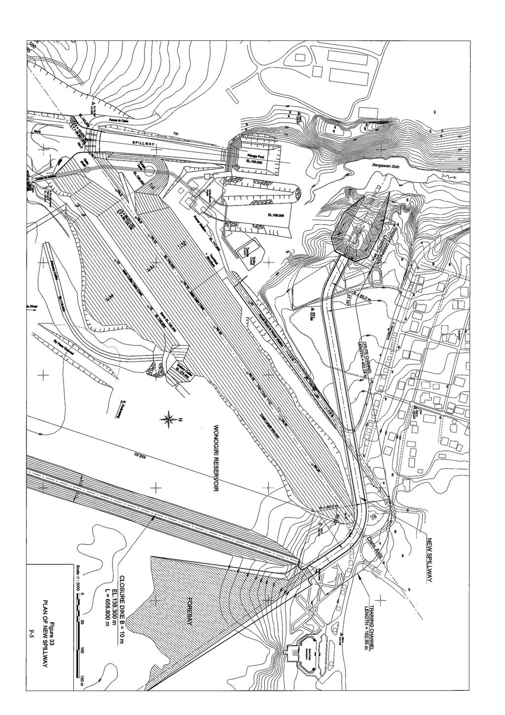
5 no serious impacts to the downstream river environments. 15. FEASIBILITY DESIGN OF SEDIMENT STORAGE RESERVOIR 15.1 Design Condition and Criteria The sediment storage reservoir was a recommended countermeasure in master plan study. Merits of this countermeasure are to; i) refrain from gathering sediment and garbage at and around the intake of Wonogiri reservoir, ii) make it possible to conduct sediment flushing/sluicing without lowering the water level of the main reservoir, resulting in few effects on the water use of storage capacity of the Wonogiri reservoir. Further, iii) as most of the facilities can be accommodated within the PBS premise, impact on the environment and social consideration will be small. The sediment storage reservoir consists of the new spillway, closure dike and overflow dike. Facilities layout plans of are shown in Figures 32 to 35. Design condition and criteria is shown in Table 28. Required structures and quantities are shown in Table 29. Table 28 Design Condition and Criteria Structure Item Condition and Criteria (1 )New Spillway Type Front overflow weir Elevation of Inlet EL m (Design deposits level) Design discharge Q=1,270 m 3 /s (at PMF) Water level EL m (2) Closure Dike Crest elevation EL m(surcharge water level) Elevation of foundation EL m(design sediment deposits level) Width of crest W=10.0 m (3) Overflow Dike Crest height Crest Height EL.136.0m Design discharge Q=550 m 3 /s (at SHFD) Sediment storage reservoir: EL m Main reservoir: EL m. Table 29 Main Composition and Quantity of Sediment Storage System Composition Item Quantity (1) New Spillway Type Front overflow weir Gate Radial gate 170t, B7.5m h12.6m 2nos Length m - Training Channel m - Chute Channel m - Energy dissipater m Width of Spillway m Concrete Volume 93,320 m 3 (2) Closure Dike (3) Overflow Dike Excavation 389,240 m 3 Backfill 134,970 m 3 Type Earth fill dike with W-wall Length of Dike 658 m Height of Dike 11.3m Embankment volume 167,800 m 3 Steel sheet pile 4,450 t Type Dike with Concrete fixed Weir Length of the Weir 250 m Height of Weir 2.0 m Excavation 29,750 m 3 Concrete 11,000 m 3 Earth filling 61,600 m 2 Nippon Koei Co.,Ltd. 43 July 2007
6 15.2 New Gate and Spillway The new spillway has functions of sediment flushing/sluicing and flood control. The new spillway with a length of 715 m will be constructed on the right abutment of Wonogiri dam. The slope of spillway chute channel is as gentle as 1/108 due to topography. A front overflow weir type is adopted for the inlet where the elevation is set at EL m, as the sediment deposit level is set at EL m. Two radial gates (B7.5 m x 2 nos. = 15.0 m) will be installed on the inlet. A ski jump type energy dissipater is adopted at the plunge pool of the spillway. Design discharge at PMF is 1,270 m 3 /sec Closure Dike The closure dike will be constructed to separate the Keduang River from main reservoir at DFWL (EL m). The earth-fill cofferdam type is adopted for the closure to secure spoil bank of excavated materials for spillway construction. The length of the dike is 660 m. The top elevation of the dike is set at EL m (SWL). The width of closure dike is 10 m. The closure dike is reinforced by double-wall sheet piles to ensure safety against scouring of the dike Overflow Dike The overflow dike will be constructed to divert the water from the sediment storage reservoir to the Wonogiri main reservoir for water storage during the wet season. The crest elevation is set at NHWL m with a length of 250 m. The concrete fixed weir type is adopted because it is maintenance free. 16. FEASIBILITY DESIGN OF WATERSHED CONSERVATION IN KEDUANG CATCHMENT 16.1 Basic Concepts and Approach The Keduang Watershed Conservation Project is formulated in principle based on the same approaches and basic concepts applied to the Master Plan Study. The approaches and basic concepts were made from considering the three aspects that are summarized by the following: Firstly water/soil conservation will be carried out by formation/upgrading of terraces and their related structures with vegetative measures. Secondly soil conservation based agricultural measures consisting of improved soil/agricultural technology and agro-forestry development will be introduced. Thirdly there will be the socio-institution aspects comprising the introduction of the community based development, creation of an implementation committee to guarantee the transparency of all the project activities, and consideration of the proper incentive to the beneficiaries Formulation of Watershed Conservation Plan (1) Demarcation of Target Area for Watershed Conservation Plan In the Feasibility Study, land use map prepared under the Master Plan Study has been updated through the detail ground truth survey. Based on the new map, the target areas for the Keduang watershed conservation project have been screened and selected by the same methodology applied to the Master Plan Study. The total target areas of 11,120 ha are demarcated as shown in Table 27, covering 82 villages in total. (2) Proposed Watershed Conservation Plan The proposed Keduang watershed conservation plan is formulated in principle based on Nippon Koei Co.,Ltd. 44 July 2007
7 the methodology applied to the Master Plan Study. The proposed basic watershed conservation measures consist of three components. First proposed component is implementation of soil conservation measures consisting of i) the bench terrace improvement and construction works, ii) improvement of waterway and drop structures, iii) improvement of side ditch in the settlement area, iv) stabilization for lip and terrace riser by vegetative measures, and v) hedge row at fringe of housing yard. Second proposed component is introduction of improved farming technology and agro-forestry development by introducing perennial estate and fruit and trees. Third proposed one is the support program for promoting water conservation project consisting of i) support programs for community development such as village action plan for soil conservation, establishment of an implementation committee, guidance for the village grant fund and education program, ii) support program for soil and water conservation measures such as farmer and farmer groups empowerment package program, package program for operation and implementation of conservation measures, and field staff empowerment program, and iii) support programs for land management and agricultural promotion measures such as the technology development program, demonstration program, pilot demonstration field of tree crops/trees and farmer and farmer group training program, farming support programs, palawija seed production program and strengthening of logistic support for extension activities. (3) Project Works The project works for the Keduang watershed conservation project are shown in the Table 28 below. The project works will be performed by introduction of farmer s participation system. Works such as cutting/filling, excavation, masonry and vegetation planting will be shared by the Government and beneficiary farmers in the project. All the materials necessary for the project such as farm inputs and construction materials are will be purchased by the Government. Table 31 Project Works item Total Total item (unit) Project Work (unit) Project Work (1,000) (1,000) 1. Land preparation 2. Side diches (for housing yard) 1) Terracing 1) Side ditch (1) Cutting and filling m 3 4,673 (1) Stone material m ) Waterway and drop (2) Excavation work m 3 29 (1) stone material m 3 44 (3) Masonry work m 3 18 (2) Excavation work m ) Headgerow (3) Masonry work m 3 40 (1) Shrub, for hedger row nr. 4,467 3) Lip and rizer, planting (2) planting work, hedge row m2 558 (1) Seedling, grass for lip nr. 83, Agro-forestry and annual crops (2) Seedling, shrub for lip nr. 5,032 1) Agro-forestry and annual crops Ls (3) Seedling, grass, for rizer nr. 115, Support program (4) Planting work, for lip m 25,258 1) Support programs Ls (5) Planting work, for rizer m2 23,188 (4) Reduction of Annual Soil Loss Soil loss in the without project condition and with project condition are calculated by using by the same methodology of USLE applied in the Master Plan Study. The annual average soil loss produced in the entire Keduang watershed is estimated as Nippon Koei Co.,Ltd. 45 July 2007
8 shown in the following table. Table 32 Reduction of Annual Average Soil Loss in Keduang Watershed Annual Average Soil Loss Reduction of (1,000 ton) Annual Average Land Categories After Soil Loss Present condition implementation (1,000 tons) (1)Paddy field (2)Settlement area (i) Home settlement area (ii) Settlement area under upland field condition 1, (3)Upland field 1, (4)Orchard and Plantation (5)Forest (6)State forest land (i) forest land (ii) Other land use (areas covered with young trees reforested and * 88 upland crops in State forest) (7)Others (lakes, roads, rivers and other use) Total 4,778 2,973 1,805 Note: In this feasibility study, a detailed land use survey was carried out for the Keduang River basin. The accuracy of current land use has been increased compared to that in the master plan stage. Therefore, the estimated average soil loss in this table is different from that in Table 21 which was estimated in the master plan stage. Remarks; *:This annual average soil loss is estimated under the land use condition in state forest area that 90% of the other land use in the state forest land will be reforested and the remaining 10% is assumed to be lost during the growing period due to pest/diseases and other risks. The annual average soil loss is estimated at 4,778 thousand tons in the without project condition and 2,973 thousand tons in the with project condition. It may be concluded from the above table that 38% of the present total annual average soil loss is trapped or reduced after implementation of the project. 17. ENVIRONMENTAL IMPACT ASSESSMENT (EIA) The result of the EIA indicated that there will be several environmental impacts evaluated as negative and significant. They are; i) impacts on air quality, noise and vibration exceeding environmental standard level due to construction works, especially excavation for spillway, and ii) impacts on local traffic and transportation due to transportation of excavated materials. These impacts will occur only during construction works and therefore the period of impact is limited. The area of impact is limited to only near villages. Accordingly, these impacts are judged not to cause serious problem but can be mitigated by proper socialization and appropriate compensation. However, the following impacts have not been completely clarified; i) impacts on fish species downstream of the Bengawan Solo River due to the change of water quality during the releasing of sediment, and ii) impacts on the downstream river environment due to garbage release from the sediment storage reservoir. Regarding these impact, it is necessary to carry out monitoring of the river environment during the release of sediment, focusing on water quality and sanitary condition of the Bengawan Solo River, so that the optimal operation of the sediment storage reservoir can be established for minimizing the environmental impacts. In conclusion, it can be assumed that with appropriate management and monitoring activities, the Project is valid from the environmental point Nippon Koei Co.,Ltd. 46 July 2007
9 of view. Table 30 below summarizes the evaluation result of environmental impacts. Table 33 Evaluation Result of Environmental Impact of the Project Project Activity Pre- Construction Project Stage Construction Operation & Maintenance Environmental Components Physical Components Biological Components Socio-economic Components Socialization of the Project Procurement of land required for project facilities Mobilization and Establishment of base camp Site clearance for project facilities Construction work, especially excavation for work Transportation of excavated materials Recruitment as construction worker Watershed management in Keduang river basin Sluicing of sediment deposits from the reservoir Periodic maintenance dredging Groundwater -TP Air Quality -P -P -TP Noise and Vibration -P -P Water Quality and River Discharge -TP Terrestrial Flora and Fauna -TP +TP Aquatic Organisms -TP Protected Species Land Acquisition and Resettlement People s Unrest -TP -TP -TP Income and Livelihood Change -TP +P -TP Economic Activities of Downstream Areas* -TP Local Traffic and Transportation -TP -P Public Health -TP -TP -TP -TP Note) -P: Negative and significant, -TP: Negative but not significant, +P: Positive and significant, +TP: Positive but not significant *: This items include: 1) sand mining, 2) inland navigation, 3) water use by PDAM and irrigation, and 5) fishery, 18. COST ESTIMATE The total cost of the Project is estimated as US$ 76.3 million excluding tax. Implementation of the Project will require a total period of 4.5 years from the commencement of the detailed engineering for structural measures. The construction works will require 2.5 years for the sediment storage reservoir, one year for procurement of dredger and 4 years for watershed conservation. Table 34 Summary of Project Cost 1. Construction Cost Item Cost (US$ thousand) a. Sediment storage reservoir 40,318 b. Watershed conservation in Keduang River basin 11,017 c. Procurement of a dredger 3, Consulting Services 5, Land Acquisition Government Administration Contingencies 15,112 Total 76,277 Nippon Koei Co.,Ltd. 47 July 2007
10 Table 35 Overall Implementation Schedule of the Project Year Major Work Item Financial Arrangement 2 Sediment Storage Reservoir Detailed Design PQ and Tender Construction 3 Watershed Conservation in Keduan Catchment Socialization and Planning Implementation Supporting Program 4 Procurement of Dredger Design Manufacturing Installation 19. PROJECT EVALUATION The economic viability of the Project is evaluated in terms of the economic internal rate of return (EIRR). The project benefit is defined as the difference of the profit between the future with project and without project conditions. The project benefits consist of irrigation, hydro-power and watershed benefits. It is assumed that water intake to provide for irrigation and hydro-power can not function by the year of 2022 in the without project condition. The benefit from the watershed conservation project is defined as incremental production of agricultural crops from land improvement and from fruit tree planting in the bench terrace area. The EIRR of the project is 16.9%. The evaluation of the Project shows that it will be economically feasible. 20. PROJECT IMPLEMENTATION 20.1 Executing and Implementation Agencies The executing agency at national level for implementing the Project will be the Directorate General of Water Resources (DGWR) of the Ministry of Public Works (MPW). At the site level, the Bengawan Solo River Basin Development Project (PBS) will act as an implementing agency Project Management Organization The DGWR as the executing agency would be assisted by related agencies. This would be done in accordance with the Memorandum of Understanding (MOU). At the outset, the MOU should be signed by Directorate General level agencies from the Ministries of Forestry and Agriculture and DGWR agreeing to overall project management by DGWR/PBS on terms specified in the MOU. This agreement would then be made known to Central Java Province and Kabupaten Wonogiri forestry, agriculture and public works services. The diagram as shown in Figure 36 below outlines the proposed project management organization down to district level to implement the Project. Nippon Koei Co.,Ltd. 48 July 2007
11 Ministry of Forestry Ministry of Agriculture Ministry of Public Works National DG Land Rehabilitation DG Land and Water DGWR Other Agencies Level and Social Forestry Management Executing Agency Related DGWR sub-directorates BPDAS Solo Central Java Agriculture Service PBS Implementing Agency Province / Watershed Level Wonogiri Kabupaten Forestry Wonogiri Kabupaten Agriculture PBS PMU Other Agencies District Level Non-structural Measure (Watershed conservation) Structural Measure (Sediment storage reservoir) Figure 36 Project Management Organization The DGWR would establish a Project Management Unit (PMU) at the district level. The PMU will be under the direct control of PBS as the implementing agency and would be responsible for the day-to-day supervision and coordination of the two constituent projects; construction of sediment storage reservoir and watershed conservation works Organization Set-up for Watershed Conservation Activities at Field and Village Levels Communities at village level should take a responsible role for the watershed conservation activities. As practitioners, the communities are essential from the planning stage and through the collaborative activities of all stakeholders. The implementation arrangement at field and village levels should be initiated with an Implementation Committee to be established at village level. The implementation committee is responsible for; i) supervision of all the conservation works and activities in village, ii) coordination with PMU and agencies concerned, and iii) operation of the village grant fund. The member of the implementation committee should be selected with transparency at the beginning of the implementation under the guidance and support of PMU. As shown in Figure 37, formation and empowerment of beneficiaries or practitioner groups, Kelompok Konservasi Tanah dan Air (K2TA; Soil and Water Conservation Farmer Group) will also be established at the field level. Such formation and introduction empowerment guidance is to be put in place about a year prior to the implementation of conservation works. The K2TA is responsible for; i) terracing, ii) agro-forestry development, iii) monitoring and evaluation, and iv) supporting program for community development. Nippon Koei Co.,Ltd. 49 July 2007
12 21. OPERATION AND MAINTENANCE PLAN 21.1 Organizational Reform for Balai Besar Wilayah Sungai The Ministry of Public Works (MPW) decided to consolidate several water resources management implementing organizations, including river basin development projects, flood control and coastal protection projects and Jasa Tirta Public Corporations (PJTs), into one water resources managing institution for each major river basin. Such institutions were named as Balai Besar Wilayah Sungai (River Basin Office). Similar institutions for smaller less developed river basins would be known as Balai Wilayah Sungai. The organization and management of Balai Besar Wilayah Sungai is set out in MPW Regulation No.12/PRT/M/2006. Figure 38 shows the organizational structure of Balai Besar Wilayah Sungai. As shown, TIUs at national and provincial levels can provide assistance to provincial and kabupaten water resources services, if requested. In addition, provincial and kabupaten water resources services can undertake tasks (if they agree) for national and provincial governments respectively, for which they would be compensated financially. In the Bengawan Solo River basin, the current organization structure of PBS was changed and the Balai Besar Wilayah Sungai Bengawan Solo was established in January The organization structure of Balai Besar Wilayah Sungai Bengawan Solo is shown in Figure Operation Works of Sediment Storage Reservoir The Wonogiri reservoir will be divided into two reservoirs by the closure dike; a sediment reservoir and the Wonogiri main reservoir. The storage capacity of the sediment storage reservoir is small at around 11 million m 3 at the CWL m. Both reservoirs are to be operated independently. The current reservoir operation rule of the Wonogiri dam is unchanged and thus will be applied to the operation of Wonogiri main reservoir as summarized below: Table 36 Reservoir Operation Rule Definition Wonogiri main Reservoir Sediment Storage Reservoir 1. Period (Article 3) Flood December 01 to April 15 December 01 to April 15 Non-flood May 01 to November 30 May 01 to November 30 Recovery April 16 to April 30 April 16 to April Flood discharge Inflow discharge exceeding 400 m 3 /s Inflow discharge exceeding 400 m 3 /s (Article 2) 3. Water Level in Flood Maintain CWL m, Flood control Maintain CWL m, Flood control Period (Article 13) 4. Water Level in Non-Flood Period (Article 13) capacity (El m El m) Draw down of El m El m, water use capacity for irrigation and hydropower Note: Article Number is from Manual for Operation and Maintenance, February 1984 capacity (El m El m) Draw down of El m El m, water use capacity to the main reservoir thru the connecting conduit Figure 37 below illustrates typical operation of the sediment storage reservoir and Wonogiri main reservoir compared to the current operation of Wonogiri reservoir. Nippon Koei Co.,Ltd. 50 July 2007
13 Month Oct. End of Dry Season Present Operation of Wonogiri Reservoir Keduang River Operation of Sediment Storage reservoir Sediment Storage Reservoir Closure Dike Dam Reservoir is empty New Spillway Nov. Beginning of Wet Season Sediment & Garbage inflow from Keduang River Main Reservoir No Sediment Release Dec. Sediment & Garbage inflow from Keduang River No Sediment Release Jan. Overflow through Overflow Dike No Sediment Release Figure 40 Illustration of Monthly Operation of Current Wonogiri Reservoir and Sediment Storage Reservoir (1/3) Nippon Koei Co.,Ltd. 51 July 2007
14 Month Feb. Present Operation of Wonogiri Reservoir Operation of Sediment Storage reservoir Start of Sediment Release Mar. Start of Sediment Release Apr. End of Wet Season No Sediment Release May. Beginning of Dry Season No Sediment Release Figure 40 Illustration of Monthly Operation of Current Wonogiri Reservoir and Sediment Storage Reservoir (2/3) Nippon Koei Co.,Ltd. 52 July 2007
 Nippon")
15 Month Jun. Present Operation of Wonogiri Reservoir Operation of Sediment Storage reservoir No Sediment Release Jul. No Sediment Release Aug. No Sediment Release Sep. End of Dry Season Reservoir becomes empty Reservoir becomes empty Figure 40 Illustration of Monthly Operation of Current Wonogiri Reservoir and Sediment Storage Reservoir (3/3) Nippon Koei Co.,Ltd. 53 July 2007
16 22. INSTITUTIONAL STRENGTHENING FOR WATERSHED MANAGEMENT The inequity of benefits between upstream and downstream of the Wonogiri dam has long been a source of dissatisfaction for the upstream communities and has been discussed many times in workshops and other forums. But to date, nothing has been implemented. A procedure has been suggested to transfer funds from downstream beneficiaries to farmers upstream. The scheme would distribute collected money to upstream villages and rely on village or sub village level agencies to distribute equitably to watershed conservation works and, if appropriate, individual farmers, although this is less likely. The money should be used as far as possible on formally planned soil conservation measures which are currently unfunded. Preliminary study on the scheme requirement and possible sequence of actions was carried out with several suggestions on possible agencies for actions. It would involve up to 250,000 farmers as well as government agencies in forestry, agriculture and finance in up to seven kabupatens in Central Java, and in Central Java Province itself, and NGOs. Therefore implementation will require a significant amount of further design work, costing and consultation. It is recommended that further investigation should be undertaken by those with a thorough knowledge of upstream and downstream farmers and community organizations. A pilot implementation of a Wonogiri Watershed Conservation Coordination Committee (WC3) is recommended. This comes from an increasing need for improved coordination of; i) watershed management in upstream catchments like that of Wonogiri dam, and ii) watershed management in the framework of water resources management in river basins generally. This problem is being addressed nationally by the GN-KPA movement. The purpose of WC3 would be to coordinate the planning, implementation, monitoring and evaluation of all watershed management in the Wonogiri watershed. This would be done using the responsible local government agencies and assisted by stakeholders representing the main interests in the area or who can provide technical advice and support. It is recommended that Dinas Agriculture and Sub-Dinas Forestry in Kebpaten Wonogiri should be strengthened by increasing available funds, staff and equipment, and by putting more emphasis on field staff training. Central Government should supply them with sufficient funds to allow adequate capacity building. 23. TECHNOLOGY TRANSFER Technology transfer is one of the main objectives of this Study. Technology transfer has been conducted by means of on-the-job training, joint meetings and workshop/seminar during the course of the Study. Joint meetings with counterpart personnel were started in November 2004 during the first field works in Indonesia. In total meetings were held 19 times during the first and the second field works. The GIS training seminars for Wonogiri GIS database developed by the Study Team were conducted twice during the periods from November 28, 2005 to December 2, 2005 and December 11-14, Workshops have been held four times for incorporating the various demands and needs of communities and stakeholders into the planning process and for empowering the stakeholders. Nippon Koei Co.,Ltd. 54 July 2007
17 24. CONCLUSIONS AND RECOMMENDATIONS 24.1 Conclusions It may be concluded from both the Master Plan Study and Feasibility Study that: i) The Wonogiri multipurpose dam completed in 1981 is the sole large reservoir on the Bengawan Solo River. The Wonogiri dam has contributed much to social welfare in the basin and has greatly benefited the country in terms of both regional and national economic developments. ii) The Wonogiri reservoir has been suffering from sediment deposits and garbage at the intake that provides water for power generation and irrigation water supply. The Keduang River that enters the reservoir just upstream of the dam is the primary cause of the current sediment-related problems. The sediment and garbage from the Keduang River have deposited massive quantities of sediment in the forebay adjacent to the dam. The reservoir sedimentation survey in 2006 showed sediment deposition depth of approximately 20 m in maximum in the forebay. It was predicted that in the near future the forebay area would be completely filled with sediment deposits due to continuing sediment inflow from the Keduang River. Establishment of sustainable sediment management system in the reservoir has become crucial. iii) The main source of the sediment was identified as the soil erosion from the cultivated upland fields and settlement areas within the Wonogiri dam watershed. The volume of annual soil erosion is estimated at around 93% of the annual sediment inflow into the reservoir (annual average 3.2 million m 3 in ). Such high soil erosion rate might be caused as a consequence of the poor land management and agricultural development that local farmers had to adopt, due to poverty and the large farming population, in the topographically critical areas on steeper mountain slopes. Out of sub-watersheds, the Keduang watershed produces the highest soil loss. iv) Urgent countermeasures (the Project) were proposed in the Master Plan. The Project aims at securing the proper function of the intake with provision of combination of structural and non-structural measures to cope with the sediment inflow into the reservoir from the Keduang River. The watershed conservation in the Keduang sub-watershed as the non-structural measure will mitigate sediment yield, thereby reducing the sediment inflow from its watershed. The sediment storage reservoir as the structural measure will release the sediment inflow from the Keduang River to the downstream reach through the new spillway; thereby the sedimentation at the intake will be drastically decreased. v) Most of the sediment and garbage inflow from the Keduang River will be completely retained in the sediment storage reservoir. The existing intake will become completely relieved from the current sediment-related issues. The retained sediment and garbage in the sediment storage reservoir will be easily released from the new spillway. vi) Implementation of the watershed conservation will be carried out by means of community-based management, encouraging the local farmers to increase farm income and thereby to improve the quality of life by improving their current land use practices. This comprehensive approach for the watershed conservation will much contribute to poverty alleviation providing stabilization of the farmers economic situation. vii) The Project is technically sound and economically feasible, showing high economic Nippon Koei Co.,Ltd. 55 July 2007
18 viability with an EIRR 16.4%. The Project will make sustainable operation of the Wonogiri reservoir possible and contribute to stabilization of the livelihood of people in the local communities as well as improvement of social welfare from the national economic points of view Recommendations Recommendations from both the Master Plan Study and Feasibility Study are summarized below: i) The Wonogiri dam is one of the lifelines of the national infrastructures. The economic value of the Wonogiri dam for water storage is undoubtedly very high. As stipulated in the Scope of Works, it was agreed between DGWR and JICA that the goals of the Study is to implement the proposed countermeasures to secure the long-term ability of the Wonogiri reservoir. Because of the urgent needs to cope with the sediment inflow, the Project should be implemented as early as possible to keep the intake functioning properly. ii) In the highly populated Java Island, the reservoir is a precious water source that would be very difficult to replace when once it is completely filled with sediments. From a realistic view points, it would be difficult to develop a new reservoir. It is strongly recommended that technical approaches and solutions provided under the Study should be applied to solve similar sedimentation problems in the existing reservoirs in Indonesia. 25. STEERING COMMITTEE MEETING ON MAY 30, 2007 The Steering Committee Meeting was held in Jakarta on May 30, 2007 to discuss the content of the Draft as well as the comment at the JICA Advisory Committee Meeting held at the JICA headquarters in Tokyo on May 24, The Advisory Committee organized by JICA provides technical guidance and advices to the JICA Study at milestone stages of the Study. The Advisory Committee advised to confirm the intension of the Government of Indonesia to implement the watershed conservation project for the Keduang River basin as the urgent plan. This was due to the consideration that as the reduced portion of the sediment inflow from the Keduang River basin by the watershed conservation works could be released to the downstream reach through the new spillway in the sediment storage reservoir, watershed conservation works for another river basin might be given the higher priority in view of effectiveness of investment. As a result of discussion at the Steering Committee Meeting, the Government of Indonesia decided to implement the watershed conservation project for the Keduang River basin as the urgent plan based on the following reasons: i) For the implementation of the watershed conservation project as proposed by JICA Study, coordination and integration with the ongoing community-based programs in the Wonogiri dam catchment, mainly Keduang River basin, under GNKPA (i.e. coordination programs among Ministry of Public Works, Ministry of Forestry and Ministry of Agriculture in accordance with the MOU) would be very important. ii) Flood control is the main function of the Wonogiri reservoir. In view of mitigation of flood and sediment inflow, watershed conservation and management for the Keduang River basin would be ranked as top priority. Nippon Koei Co.,Ltd. 56 July 2007
19 iii) The sediment storage reservoir would become check dam or sand pocket in future without proper operation. If the sediment storage reservoir is filled with sediment deposits, almost all of the sediment inflow from the Keduang River would overflow into the main Wonogiri reservoir. To avoid this critical situation, proper operation of sediment storage reservoir and watershed conservation in the Keduang River basin would be very important. Nippon Koei Co.,Ltd. 57 July 2007
20
21 Table 8 Evaluation Results of Alternatives for Sediment Deposits and Garbage at Intake Alternative 1) Modification of intake 2) Relocation of intake 3) Garbage trapping structure at intake 4) Garbage trapping structure in the Keduang River 5) Dredging by hydro-suction method 6) Hydraulic dredging Construction Cost $3,160,000 $8,800,000 $3,670,000 $1,370,000 $2,875,000 $4,456,700 Technical Applicability Not sustainable solution because sedimentation will continue year by year over the inlet elevation at the intake. Sedimentation will occur at the new intake, although sedimentation rate is small compare to that at the existing intake. Periodic dredging at the new intake would be required in the future. Blocking of the intake will be solved by periodical garbage removal. Sediment deposits at the intake shall be solved by other structural measures. Periodical removal of the trapped garbage will be required. Sediment inflow flow Keduang River continues to enter into the reservoir without being trapped. There are operational constraints depending on the reservoir water level because of necessity of water head difference. Most common measures for removing sediment deposits in reservoir. Huge spoil bank areas are required. Environmental and Social Impacts Irrigation water supply and power generation shall be suspended due to temporary stoppage of the intake during construction. Irrigation water supply and power generation shall be suspended due to the connection work with the existing intake. Large disposal area will be necessary. Magnitude of impact will be larger due to Water supply shall be suspended due to temporary stoppage of the intake during construction. Positive impact will occur. Degradation of water quality in the reservoir will be mitigated owing to trapping of garbage from the Keduang River. Possible negative impact on water quality of downstream Bengawan Solo River due to release of dredged sediment. Relatively less impact because of lots of worldwide experiences provided with spoil bank areas. Nippon Koei Co.,Ltd. T-1 July 2007
22 Alternative 1) Keduang River sediment bypass 2) Sediment sluicing by new gates 3) Sediment storage reservoir with new gates in the reservoir Table 10 Comparison of Alternatives for Sediment Inflow from Keduang River Construction Cost, Unit Cost and Released Sediment $82,940,000 $10.7/m 3 476,000 m 3 /year $35,630,000 $4.7/m 3 509,000 m 3 /year $47,090,000 $3.8/m 3 1,280,000 m 3 /year Technical Applicability Technically applicable. But due to small discharge capacity of bypass tunnel (50 m 3 /sec) flood inflow from the Keduang River with high sediment concentration cannot be fully diverted. Considerable volume of sediment flow as well as garbage from the Keduang River enters the Wonogiri reservoir. Modification of intake or periodic dredging at the intake will be indispensable in view of sustainable operation of the reservoir. Huge construction cost will be required. Technically applicable. Sluicing operation will be applicable at the beginning of wet season only when the water level is the lowest. If the gates are fully opened, considerable amount of garbage would be released to the downstream reach. However, release flow from the gates shall be controlled not to exceed 400 m 3 /s according to the current reservoir operation rule. There is a risk that the reservoir water level can not reach NHWL at the end of wet season when much water is used for sluicing. More than half of the sediment inflow from the Keduang River will be deposited in the reservoir. Periodic maintenance dredging at the intake is necessary. Technically applicable. Sediment sluicing (sediment routing) and flushing contemplates to effectively utilize the water power (sediment transport capacity) of a natural river with less running cost. As the sediment storage reservoir can be operated independently from the Wonogiri main reservoir, the current operation rule can be applied for sediment releasing operation. After the reservoir water level reaches NHWL, sediment releasing operation will be started without using the stored water in the main reservoir. Environmental and Social Impacts Serious negative impacts with larger magnitude will occur. Huge disposal areas of excavated materials (around 270,000 m 3 ) spawned by tunneling are necessary. It might be very difficult to secure spoil bank areas near the dam area. Impacts during construction works include topographic and geologic changes, waste of excavated materials, drawdown of groundwater level and inconvenience of well water use, air quality, noise,unrest of local people, some conflicts/opposition from local people, etc. Highly turbid water from the Keduang River will be released. The released turbid water might cause negative impacts on aquatic organisms, especially fish. At the worse, high concentration of SS might cause a respiratory impediment of fishes. Huge disposal areas of excavated materials (around 800,000 m 3 ) are necessary. It might be very difficult to secure spoil bank areas near the dam area. Impacts during construction works include topographic and geologic changes, waste of excavated materials, air quality and noise, etc. Highly turbid water from the Keduang River will be released through the new gates. The released turbid water might cause negative impacts on aquatic organisms, especially fish. At the worse, high concentration of SS might cause a respiratory impediment of fishes. Huge disposal areas of excavated materials (around 800,000 m 3 ) are necessary. It might be very difficult to secure spoil bank areas near the dam area. Impacts during construction works include topographic and geologic changes, waste of excavated materials, air quality and noise, etc. Note: Released sediment volume is estimated from the reservoir sedimentation simulation analysis applying the inflow of hydrological wet year 1998/99. Unit cost for sediment releasing is estimated based on the construction cost and required O&M cost for 50 years. Nippon Koei Co.,Ltd. T-2 July 2007
23 Table 11 Evaluation Results of Alternatives for Sediment Inflow from Other Tributaries Alternative 1) Sediment storage dam for sediment removal 2) Hydraulic dredging in reservoir 3) Dry excavation in reservoir 4) Managing of sediment within the reservoir by water releasing from the intake 5) Dam heightening Construction Cost $225,460,000 $44,567,000 $287,990,000 $0 No Estimation Technical Applicability Technically applicable but not sustainable solution in view of practicability. Around 83 units of storage dam would be necessary for trapping the annual sediment deposition volume of 2.0 million m 3 from other tributaries. Continuous sediment removal works for 2.0 million m 3 will be necessary every year. It would not be practical and applicable. Technically applicable but not sustainable solution in view of practicability.10 dredgers would be necessary to dispose the annual sediment deposition volume of 2.0 million m 3. Huge running cost and spoil bank areas are required. It will not be practical and applicable. In view of sustainable and economical measure, dry excavation deems not applicable. So many equipments such as bulldozers, crawler loaders and dump trucks would be necessary to excavate the annual sediment deposition volume of 2.0 million m 3. Huge running cost and spoil bank areas are required. By use of the maximum intake discharge (70 m 3 /s) for power generation, previously deposited sediments are moved toward the dead zone of the reservoir, thereby maintaining or increasing the effective capacity of the reservoir. However, reliability of this method will be considered to be low, because of likely blocking of the intake due to garbage. This method is to raise the dam crest to secure the effective storage capacity. Dam heightening would be the option to adopt in the future when the storage capacity of the reservoir decreased substantially. The Steering Committee on August 22, 2005 concluded dam heightening not recommendable. Environmental and Social Impacts Huge disposal areas are necessary for periodic sediment removal works. It would be impossible to secure annually spoil bank areas for spoiling 2.0 million m 3 of sediments near the reservoir. Huge disposal areas are necessary for dredging works. It would be impossible to secure annually spoil bank areas for disposing 2.0 million m 3 of dredged sediments near the reservoir. Huge disposal areas are necessary for periodic sediment removal works. It would be impossible to secure annually spoil bank areas for spoiling 2.0 million m 3 of sediments near the reservoir. Possible impacts on air quality, noise and transportation during the excavation works. Significant amount of water must be released through power generation, and there is a risk that the reservoir water level can not reach NHWL. This might cause water deficit for irrigation in downstream area and impacts on paddy fields in case of inappropriate water release. It might spawn people s unrest or conflict. This measure might cause social controversy because it would require large area of land acquisition and possibly resettlement. Not only the social controversy, but also a large scale of civil work would be needed, which may cause serious negative impacts on the local residents. Nippon Koei Co.,Ltd. T-3 July 2007
24 Table14 Coding of Land Units in Subject Areas Slope Class (%) Terrace Type & Condition >40 Upland Field - Good Quality BT * US1T1 US2T1 US3T1 US4T1 US5T1 - Medium Quality BT US1T2 US2T2 US3T2 US4T2 US5T2 - Fair/Bad Quality BT US1T3 US2T3 US3T3 US4T3 US5T3 - Traditional Terrace US1T4 US2T4 US3T4 US4T4 US5T4 - Composite ** US1T5 US2T5 US3T5 US4T5 US5T5 Settlement area under Upland Field - Complex (composite and traditional terrace) PS1T6 PS2T6 PS3T6 PS4T6 PS5T6 Housing Yard HS1 HS2 HS3 HS4 HS5 *: BT = bench terrace **: Association of ridge and non-terrace Table 15 Subject Area Classified by Coding of Land Units (ha) in the Wonogiri Dam Watershed Slope Class (%) Total (%) >40 Upland Field -Good quality BT* Medium quality BT , Fair/Bad quality BT 4,644 2,508 2,539 2,904 5,263 17, Traditional terrace ,119 1,633 5, Composite** 1,351 1,629 2,482 3,366 5,249 14, Uplands in settlement area (complex of traditional terrace and composite) 9,526 4,152 2,660 1,617 1,520 19, Settlement area (housing yard) 2,480 1,620 1, , Total (ha) 19,660 11,190 10,350 10,270 15,050 66,520 (%) Note: Subject area does not include the State Forest area *: BT= bench terrace **: Association of ridge and non-terrace Nippon Koei Co.,Ltd. T-4 July 2007
25 Table16 Target Areas for Watershed Conservation by Sub-Basin ( ) Unit: ha Code of Keduang Tirtomoyo Temon Upper Alang Ngungga- Wuryan- Remnant Total (%) land Solo han toro (ha) US1T US2T US3T US4T US5T US1T US2T US3T US4T US5T US1T US2T ,848 5 US3T ,862 5 US4T ,693 5 US5T3 1, ,515 7 US1T US2T US3T US4T US5T US1T US2T ,292 4 US3T ,174 6 US4T ,451 7 US5T , ,956 9 PS1T5 1, ,695 8 PS2T5 1, , PS3T5 1, ,485 7 PS4T ,196 3 PS5T HS HS HS HS HS Total (ha) 11,260 6,890 1,785 6,898 3,228 1,702 1, , (%) Upland Field Land use Bench terrace Settlement area good medium fair/poor Traditional terrace Composite (ridge and non terrace) Settlement area under upland field condition Nippon Koei Co.,Ltd. T-5 July 2007
26 Table 30 Target Areas for Watershed Conservation in Keduang Watershed Upland Field Land use Bench terrace good medium fair/poor Traditional terrace Composite (ridge and non terrace) Code of Area Land use Code of Area land (ha) land (ha) US1T1 0 PS1T6 1,520 US2T1 0 PS2T6 1,765 US3T1 0 PS3T6 1,039 US4T1 0 PS4T6 394 Uplands in settlement area (complex) US5T1 0 PS5T6 365 sub-total 0 sub-total 5,083 US1T2 0 HS1 0 US2T2 6 HS2 569 US3T2 8 HS3 372 US4T2 7 HS4 185 Settlemt area US5T2 3 HS5 270 sub-total 24 sub-total 1,396 US1T3 0 US2T3 984 US3T3 1,027 US4T3 870 US5T3 1,392 sub-total 4,273 US1T4 3 US2T4 40 US3T4 33 US4T4 26 US5T4 71 sub-total 173 US1T5 1 US2T5 9 US3T5 31 US4T5 44 US5T5 82 sub-total 167 Total 11,116 Unit: ha Nippon Koei Co.,Ltd. T-6 July 2007
27
28 >50 >50 >50 The Study on Countermeasures for Sedimentation B-3 EL.= m L=20 m SPT N value 0 50 SPT N value >50 41 >50 >50 B-1 EL.= m L=25 m SPT N value >50 >50 44 >50 B-2 EL.= m L=25 m 137Lu (6.1E-4) 25Lu E-4) E E E-5 ( BS-1 L=30m X:492,486 Y:9,133,951 EL=143,500 m SPT N value E BS-4 L=30m X:492,505 Y:9,133,913 EL=141,700 m SPT N value 5.2Lu E-5) E E E E E-4 ( >50 >50 >50 B-4 EL.= m L=20 m EL.(m) Dam Reservoir Dam Axis LEGEND Talus Deposit Tarrace Deposit Lapilli Tuff (D class) Volcanic Breccia (D/CL class) Sandy Tuff (D/CL class) Tuff Breccia (D class) Tuff Breccia (CM class) Groundwater Surface 170 EL.(m) SPT N value Solo River (m) 50 Hole name, Evelavation of the top of the hole Hohe length Stiff Layer Surface (N value >50) Residual Soil Talus deposit Alluvial deposit Silt & Clay Sand Gravel Bedrock Volcanic Breccia Tuff SandyTuff Tuff Breccia 0 35 Soil DL Class DH Class CL Class N Value RQD SPT Values More than 50 Figure 29 Geological Profile of Proposed Spillway Alignment Nippon Koei Co.,Ltd. F-1 July 2007

29 Figure 30 Geological Profile of Closure Dike Nippon Koei Co.,Ltd. F-2 July 2007
30 i) Before opening gate - SS concentration of dam outflow and that in the downstream stretch were significantly lower than current condition. D/S of DAM (0.7km) New gates opened Without Measure With Measure COLO (14km) JURUG (52km) SS (kg/m3) SS (kg/m3) /11/1 1998/12/1 1998/12/ /1/ /3/1 1999/3/ /4/ /5/ /11/1 1998/12/1 1998/12/ /1/ /3/1 1999/3/ /4/ /5/ Without Measure With Measure Without Measure With Measure iii) After opening gates - dam outflow and mainstream below the dam contained highly turbid water by sediment releasing operation. As well the frequency of occurrence of higher SS concentration would increase. iv) After opening gates - at dtream of the dam and the Colo, peak values of SS concentration were almost the same as those observed in the beginning of wet season on the current condition. SS (kg/m3) ii) Before opening gate - At Jurug and Tangen which located far downstream of the dam, high SS concentration were disappeared. TANGEN (97km) SS (kg/m3) /11/1 1998/12/1 1998/12/ /1/ /3/1 1999/3/ /4/ /5/ Without Measure With Measure iv) After opening gate - During the opening of the new gates, the peak of SS concentration at Jurug and Tangen were significantly higher than those of current condition in case the inflow discharge from tributaries were small. In such condition, the impact of sediment releasing operation would be relatively sever /11/1 1998/12/1 1998/12/ /1/ /3/1 1999/3/ /4/ /5/30 Note: Without Measure is the case in present condition assuming for dam operation to follows the existing rule. With Measure is the case after implementation of the measure (Sediment storage reservoir with new gates). Source : JICA Study Team Figure 31 Comparison of SS concentration in Upper Solo Mainstream between With and Without Measure in Wet Year (1998/1999) Nippon Koei Co.,Ltd. F-3 July 2007
31
32
FINAL REPORT VOLUME-I EXECUTIVE SUMMARY
 Directorate General of Water Resources Ministry of Public Works The Republic of Indonesia THE STUDY ON COUNTERMEASURES FOR SEDIMENTATION IN THE WONOGIRI MULTIPURPOSE DAM RESERVOIR IN THE REPUBLIC OF INDONESIA
2. PRESENT CONDITION OF THE RESERVOIR 2.1 View of Wonogiri Reservoir (1/3)
") 2.1 View of Wonogiri Reservoir (1/3) Wonogiri dam abutment on the left side of dam Spillway forebay on thet left side of dam Bank erosion around Wonogiri reservoir. Wonogiri Dam view from chersonese. An
2.1 View of Wonogiri Reservoir (1/3) Wonogiri dam abutment on the left side of dam Spillway forebay on thet left side of dam Bank erosion around Wonogiri reservoir. Wonogiri Dam view from chersonese. An
FINAL REPORT VOLUME-VII PHOTO BOOK
 Directorate General of Water Resources Ministry of Public Works The Republic of Indonesia THE STUDY ON COUNTERMEASURES FOR SEDIMENTATION IN THE WONOGIRI MULTIPURPOSE DAM RESERVOIR IN THE REPUBLIC OF INDONESIA
Analysis of Sedimentation in Wonogiri Reservoir
 Journal of the Civil Engineering Forum Vol. 2 No. 1 (January 2016) Analysis of Sedimentation in Wonogiri Reservoir Tri Joko Inti Budi Santosa Large River Basin Organization of Bengawan Solo, Surakarta,
Sedimentation in the Nile River
 Advanced Training Workshop on Reservoir Sedimentation Sedimentation in the Nile River Prof. Dr. Abdalla Abdelsalam Ahmed 10-16 Oct. 2007, IRTCES, Beijing, China CWR,Sudan 1 Water is essential for mankind
Terms of Reference for the Comparative Environmental Review (CER) of. Options for the Mactaquac Project, Mactaquac, New Brunswick
 of. Options for the Mactaquac Project, Mactaquac, New Brunswick") Terms of Reference for the Comparative Environmental Review (CER) of Options for the Mactaquac Project, Mactaquac, New Brunswick Preamble The New Brunswick Power Corporation ( NB Power ) operates the Mactaquac
Terms of Reference for the Comparative Environmental Review (CER) of Options for the Mactaquac Project, Mactaquac, New Brunswick Preamble The New Brunswick Power Corporation ( NB Power ) operates the Mactaquac
CASE STUDY NATHPA JHAKRI, INDIA
 SEDIMENT MANAGEMENT CASE STUDY NATHPA JHAKRI, INDIA Key project features Name: Nathpa Jhakri Country: India Category: reduce sediment production (watershed management); upstream sediment trapping; bypass
RETA 6422: Mainstreaming Environment for Poverty Reduction Category 2 Subproject
 RETA 6422: Mainstreaming Environment for Poverty Reduction Category 2 Subproject A. Basic Data 1. Subproject Title: Poverty-Environment Mapping to Support Decision Making 2. Country Director: Adrian Ruthenberg
CASE STUDY NATHPA JHAKRI, INDIA
 SEDIMENT MANAGEMENT CASE STUDY NATHPA JHAKRI, INDIA Key project features Name: Nathpa Jhakri Country: India Category: reforestation/revegetation; upstream sediment trapping; bypass channel/tunnel; reservoir
PRELIMINARY DRAFT FOR DISCUSSION PURPOSES
 Memorandum To: David Thompson From: John Haapala CC: Dan McDonald Bob Montgomery Date: February 24, 2003 File #: 1003551 Re: Lake Wenatchee Historic Water Levels, Operation Model, and Flood Operation This
EROSION SOURCES AND SEDIMENT YIELD FROM THE WONOGIRI DAM WATERSHED
 CHAPTER 4 EROSION SOURCES AND SEDIMENT YIELD FROM THE WONOGIRI DAM WATERSHED 4.1 Erosion Sources of Sediment Deposits in the Wonogiri Reservoir Almost all sediment deposits in the Wonogiri reservoir have
CASE STUDY BINGA, PHILIPPINES
 SEDIMENT MANAGEMENT CASE STUDY BINGA, PHILIPPINES Key project features Name: Binga Country: Philippines Category: modify operating rule (focus or redistribute sediment); adaptive strategies Reservoir volume
Annex No.6 Turbidity Analysis for Downstream Reaches, Solo River Estuary and Colo Weir
 Annex No.6 Turbidity Analysis for Downstream Reaches, Solo River Estuary and Colo Weir THE STUDY ON COUNTERMEASURES FOR SEDIMENTATION IN THE WONOGIRI MULTIPURPOSE DAM RESERVOIR IN THE REPUBLIC OF INDONESIA
U.S. ARMY CORPS OF ENGINEERS
 CORPS FACTS Regulating Mississippi River Navigation Pools U.S. ARMY CORPS OF ENGINEERS BUILDING STRONG Historical Background Federal improvements in the interest of navigation on the Mississippi River
STATUS OF PROJECTS IN EXECUTION FY09 SOPE
 Public Disclosure Authorized Public Disclosure Authorized Public Disclosure Authorized Public Disclosure Authorized STATUS OF PROJECTS IN EXECUTION FY09 SOPE COUNTRY: MALAWI Operations Policy and Country
Evaluation of Deposition Pattern of Wonogiri Reservoir Sedimentation
 International Journal of Civil & Environmental Engineering IJCEE-IJENS Vol: 15 No: 02 15 Evaluation of Deposition Pattern of Wonogiri Reservoir Sedimentation D.A. Wulandari 1, D. Legono 2 & S. Darsono
Implementation Status & Results Burkina Faso TRANSPORT SECTOR PROJECT (P074030)
") losure Authorized Public Disclosure Authorized Public Disclosure Authorized Public Disclosure Authorized Implementation Status & Results Burkina Faso TRANSPORT SECTOR PROJECT (P074030) Operation Name:
losure Authorized Public Disclosure Authorized Public Disclosure Authorized Public Disclosure Authorized Implementation Status & Results Burkina Faso TRANSPORT SECTOR PROJECT (P074030) Operation Name:
The World Bank. Key Dates. Project Development Objectives. Components. Implementation Status & Results Report. Key Project Dates
 Public Disclosure Copy AFRICA Africa Environment & Natural Resources Global Practice IBRD/IDA Adaptable Program Loan FY 2009 Seq No: 11 ARCHIVED on 18-Dec-2015 ISR21679 Implementing Agencies: Ministry
Technical Review of Pak Beng Hydropower Project (1) Hydrology & Hydraulics and (2) Sediment Transport & River Morphology
 Hydrology & Hydraulics and (2) Sediment Transport & River Morphology") Technical Review of Pak Beng Hydropower Project (1) Hydrology & Hydraulics and (2) Sediment Transport & River Morphology The 2 nd Regional Stakeholder Forum The Pak Beng Hydropower Project 5 th May 2017
Technical Review of Pak Beng Hydropower Project (1) Hydrology & Hydraulics and (2) Sediment Transport & River Morphology The 2 nd Regional Stakeholder Forum The Pak Beng Hydropower Project 5 th May 2017
 Red River Flooding June 2015 Caddo and Bossier Parishes Presented by: Flood Technical Committee Where the Rain Falls Matters I-30 versus I-20 I-20 Backwater and Tributary Floods (Localized) 2016 Flood
CASE STUDY BINGA, PHILIPPINES
 SEDIMENT MANAGEMENT CASE STUDY BINGA, PHILIPPINES Key project features Name: Binga Country: Philippines Category: modify operating rule (focus or redistribute sediment); adaptive strategies Binga hydropower
Bawakaraeng Urgent Sediment Control Project
 Departmen Permukiman Umum Direktorat Jenderal Sumber Daya Air Bawakaraeng Urgent Sediment Control Project (The Most Urgent Components) August 2005 1 The Collapse On March 26, 2004, Mt. Sorongan (EL.2,541m)
The World Bank CG Rep. LISUNGI Safety Nets System Project (P145263)
") Public Disclosure Authorized AFRICA Congo, Republic of Social Protection & Labor Global Practice IBRD/IDA Investment Project Financing FY 2014 Seq No: 7 ARCHIVED on 04-Dec-2017 ISR30246 Implementing Agencies:
Public Disclosure Authorized AFRICA Congo, Republic of Social Protection & Labor Global Practice IBRD/IDA Investment Project Financing FY 2014 Seq No: 7 ARCHIVED on 04-Dec-2017 ISR30246 Implementing Agencies:
Applying Hazard Maps to Urban Planning
 Applying Hazard Maps to Urban Planning September 10th, 2014 SAKAI Yuko Disaster Management Expert JICA Study Team for the Metro Cebu Roadmap Study on the Sustainable Urban Development 1 Contents 1. Outline
Modeling Great Britain s Flood Defenses. Flood Defense in Great Britain. By Dr. Yizhong Qu
 Modeling Great Britain s Flood Defenses AIRCurrents Editor s note: AIR launched its Inland Flood Model for Great Britain in December 2008. The hazard module captures the physical processes of rainfall-runoff
Ayeyarwady Integrated River Basin Management Project (P146482)
") EAST ASIA AND PACIFIC Myanmar Water Global Practice IBRD/IDA Investment Project Financing FY 2015 Seq No: 8 ARCHIVED on 19-Dec-2018 ISR35167 Implementing Agencies: Republic of the Union of Myanmar, Directorate
EAST ASIA AND PACIFIC Myanmar Water Global Practice IBRD/IDA Investment Project Financing FY 2015 Seq No: 8 ARCHIVED on 19-Dec-2018 ISR35167 Implementing Agencies: Republic of the Union of Myanmar, Directorate
The World Bank Decentralized Community Driven Services Project (P117764)
") Public Disclosure Authorized AFRICA Benin Social Protection Global Practice IBRD/IDA Adaptable Program Loan FY 2012 Seq No: 6 ARCHIVED on 12-Jun-2015 ISR19748 Implementing Agencies: Public Disclosure Authorized
Public Disclosure Authorized AFRICA Benin Social Protection Global Practice IBRD/IDA Adaptable Program Loan FY 2012 Seq No: 6 ARCHIVED on 12-Jun-2015 ISR19748 Implementing Agencies: Public Disclosure Authorized
3.0 TECHNICAL FEASIBILITY
 3.0 TECHNICAL FEASIBILITY 3.1 INTRODUCTION To enable seasonal storage and release of water from Lake Wenatchee, an impoundment structure would need to be constructed on the lake outlet channel. The structure
HISTORY OF CONSTRUCTION FOR EXISTING CCR SURFACE IMPOUNDMENT PLANT GASTON ASH POND 40 CFR (c)(1)(i) (xii)
(1)(i) (xii)") HISTORY OF CONSTRUCTION FOR EXISTING CCR SURFACE IMPOUNDMENT PLANT GASTON ASH POND 40 CFR 257.73(c)(1)(i) (xii) (i) Site Name and Ownership Information: Site Name: E.C. Gaston Steam Plant Site Location:
HISTORY OF CONSTRUCTION FOR EXISTING CCR SURFACE IMPOUNDMENT PLANT GASTON ASH POND 40 CFR 257.73(c)(1)(i) (xii) (i) Site Name and Ownership Information: Site Name: E.C. Gaston Steam Plant Site Location:
Rock & Aggregate Drop Inlet Protection
 Rock & Aggregate Drop Inlet Protection SEDIMENT CONTROL TECHNIQUE Type 1 System Sheet Flow Sandy Soils Type 2 System [1] Concentrated Flow Clayey Soils Type 3 System Supplementary Trap Dispersive Soils
SUSTAINABLE SEDIMENT MANAGEMENT
 SUSTAINABLE SEDIMENT MANAGEMENT Shaping our world A company of OUR EXPERTISE Sediments can make or break a Project Numerous examples of dams and reservoirs can be found throughout the world whose live
SPECIFIC DEGRADATION AND RESERVOIR SEDIMENTATION. By Renee Vandermause & Chun-Yao Yang
 SPECIFIC DEGRADATION AND RESERVOIR SEDIMENTATION By Renee Vandermause & Chun-Yao Yang Outline Sediment Degradation - Erosion vs Sediment Yield - Sediment Yield - Methods for estimation - Defining Sediment
Subcommittee on Sedimentation Draft Sediment Analysis Guidelines for Dam Removal
 Subcommittee on Sedimentation Draft Sediment Analysis Guidelines for Dam Removal August 4, 2011 Jennifer Bountry, M.S., P.E. Tim Randle, M.S., P.E., D.WRE. Blair Greimann, Ph.D., P.E. Sedimentation and
B805 TEMPORARY EROSION AND SEDIMENT CONTROL MEASURES - OPSS 805
 B805 MEASURES - OPSS 805 805.1 GENERAL Construction activities frequently remove protective cover and expose soil to accelerated rates of erosion. Sediments generated thereby can be conveyed via runoff
GIS Geographical Information Systems. GIS Management
 GIS Geographical Information Systems GIS Management Difficulties on establishing a GIS Funding GIS Determining Project Standards Data Gathering Map Development Recruiting GIS Professionals Educating Staff
The World Bank. Key Dates. Project Development Objectives. Components. Overall Ratings. Public Disclosure Authorized
 Public Disclosure Authorized AFRICA Mali Agriculture and Rural Development Global Practice IBRD/IDA Specific Investment Loan FY 2006 Seq No: 21 ARCHIVED on 13-Jan-2015 ISR17735 Implementing Agencies: Public
The World Bank Indonesia National Slum Upgrading Project (P154782)
") Public Disclosure Authorized EAST ASIA AND PACIFIC Indonesia Social, Urban, Rural and Resilience Global Practice Global Practice IBRD/IDA Investment Project Financing FY 2017 Seq No: 4 ARCHIVED on 04-Apr-2018
Public Disclosure Authorized EAST ASIA AND PACIFIC Indonesia Social, Urban, Rural and Resilience Global Practice Global Practice IBRD/IDA Investment Project Financing FY 2017 Seq No: 4 ARCHIVED on 04-Apr-2018
Materials. Use materials meeting the following.
 208.01 Section 208. SOIL EROSION AND SEDIMENTATION CONTROL 208.01 Description. Install and maintain erosion and sedimentation controls to minimize soil erosion and to control sedimentation from affecting
Public Disclosure Copy
 Public Disclosure Authorized SOUTH ASIA Nepal Agriculture Global Practice IBRD/IDA Investment Project Financing FY 2008 Seq No: 23 ARCHIVED on 26-Jul-2018 ISR33099 Implementing Agencies: Poverty Alleviation
Strategies for managing sediment in dams. Iwona Conlan Consultant to IKMP, MRCS
 Strategies for managing sediment in dams Iwona Conlan Consultant to IKMP, MRCS 1 Sediment trapping by dams Active storage capacity Dead storage coarse material (bed load) Fine materials (suspension) Francis
Roger Andy Gaines, Research Civil Engineer, PhD, P.E.
 Roger Andy Gaines, Research Civil Engineer, PhD, P.E. Research Civil Engineer/Regional Technical Specialist Memphis District August 24, 2010 Objectives Where we have been (recap of situation and what s
[1] Performance of the sediment trap depends on the type of outlet structure and the settling pond surface area.
![[1] Performance of the sediment trap depends on the type of outlet structure and the settling pond surface area.](/thumbs/76/74245181.jpg "[1] Performance of the sediment trap depends on the type of outlet structure and the settling pond surface area.") Sediment Trench SEDIMENT CONTROL TECHNIQUE Type 1 System Sheet Flow Sandy Soils Type 2 System [1] Concentrated Flow Clayey Soils Type 3 System [1] Supplementary Trap Dispersive Soils [1] Performance of
Sediment Trench SEDIMENT CONTROL TECHNIQUE Type 1 System Sheet Flow Sandy Soils Type 2 System [1] Concentrated Flow Clayey Soils Type 3 System [1] Supplementary Trap Dispersive Soils [1] Performance of
The World Bank Mali Reconstruction and Economic Recovery (P144442)
") Public Disclosure Authorized AFRICA Mali Social, Urban, Rural and Resilience Global Practice Global Practice IBRD/IDA Emergency Recovery Loan FY 2014 Seq No: 7 ARCHIVED on 30-Jun-2017 ISR28723 Implementing
Public Disclosure Authorized AFRICA Mali Social, Urban, Rural and Resilience Global Practice Global Practice IBRD/IDA Emergency Recovery Loan FY 2014 Seq No: 7 ARCHIVED on 30-Jun-2017 ISR28723 Implementing
Folsom Dam Water Control Manual Update Joint Federal Project, Folsom Dam
 Folsom Dam Water Control Manual Update Joint Federal Project, Folsom Dam Public Workshop May 25, 2016 Sacramento Library Galleria 828 I Street, Sacramento, CA US Army Corps of Engineers BUILDING STRONG
The World Bank BiH Floods Emergency Recovery Project (P151157)
") EUROPE AND CENTRAL ASIA Bosnia and Herzegovina Social, Urban, Rural and Resilience Global Practice Global Practice IBRD/IDA Investment Project Financing FY 2014 Seq No: 4 ARCHIVED on 22-Jun-2016 ISR22737
EUROPE AND CENTRAL ASIA Bosnia and Herzegovina Social, Urban, Rural and Resilience Global Practice Global Practice IBRD/IDA Investment Project Financing FY 2014 Seq No: 4 ARCHIVED on 22-Jun-2016 ISR22737
Integrating Weather Forecasts into Folsom Reservoir Operations
 Integrating Weather Forecasts into Folsom Reservoir Operations California Extreme Precipitation Symposium September 6, 2016 Brad Moore, PE US Army Corps of Engineers Biography Brad Moore is a Lead Civil
Illinois State Water Survey Division
 Illinois State Water Survey Division SURFACE WATER SECTION SWS Miscellaneous Publication 108 SEDIMENT YIELD AND ACCUMULATION IN THE LOWER CACHE RIVER by Misganaw Demissie Champaign, Illinois June 1989
Tarbela Dam in Pakistan. Case study of reservoir sedimentation
 Tarbela Dam in Pakistan. HR Wallingford, Wallingford, UK Published in the proceedings of River Flow 2012, 5-7 September 2012 Abstract Reservoir sedimentation is a main concern in the Tarbela reservoir
How Do Human Impacts and Geomorphological Responses Vary with Spatial Scale in the Streams and Rivers of the Illinois Basin?
 How Do Human Impacts and Geomorphological Responses Vary with Spatial Scale in the Streams and Rivers of the Illinois Basin? Bruce Rhoads Department of Geography University of Illinois at Urbana-Champaign
INFLOW DESIGN FLOOD CONTROL SYSTEM PLAN 40 C.F.R. PART PLANT YATES ASH POND 2 (AP-2) GEORGIA POWER COMPANY
 GEORGIA POWER COMPANY") INFLOW DESIGN FLOOD CONTROL SYSTEM PLAN 40 C.F.R. PART 257.82 PLANT YATES ASH POND 2 (AP-2) GEORGIA POWER COMPANY EPA s Disposal of Coal Combustion Residuals from Electric Utilities Final Rule (40 C.F.R.
INFLOW DESIGN FLOOD CONTROL SYSTEM PLAN 40 C.F.R. PART 257.82 PLANT YATES ASH POND 2 (AP-2) GEORGIA POWER COMPANY EPA s Disposal of Coal Combustion Residuals from Electric Utilities Final Rule (40 C.F.R.
RESERVOIR DRAWDOWN RATES/RESERVOIR DRAWDOWN TEST Iron Gate, Copco (I & II), and JC Boyle Dams
, and JC Boyle Dams") TECHNICAL MEMORANDUM No. 1 TO: Michael Bowen California Coastal Conservancy Geotechnical & Earthquake Engineering Consultants CC: Eric Ginney Philip Williams & Associates PREPARED BY: Paul Grant SUBJECT:
TECHNICAL MEMORANDUM No. 1 TO: Michael Bowen California Coastal Conservancy Geotechnical & Earthquake Engineering Consultants CC: Eric Ginney Philip Williams & Associates PREPARED BY: Paul Grant SUBJECT:
National Hydrology committee of Afghanistan (NHCA) Sedimentation in Reservoire
 Sedimentation in Reservoire") National Hydrology committee of Afghanistan (NHCA) Sedimentation in Reservoire OCt.2007 Prof. Mohammad Qasem Seddeqy KPU بسم االله الرحمن الرحيم وجعلنامن الماءکل شي ء حی 30 واز ا ب هر چيزی رازنده گردانيدیم
National Hydrology committee of Afghanistan (NHCA) Sedimentation in Reservoire OCt.2007 Prof. Mohammad Qasem Seddeqy KPU بسم االله الرحمن الرحيم وجعلنامن الماءکل شي ء حی 30 واز ا ب هر چيزی رازنده گردانيدیم
Implementation Status & Results Ethiopia Tana & Beles Integrated Water Resources Development (P096323)
") Public Disclosure Authorized Public Disclosure Authorized The World Bank Implementation Status & Results Ethiopia Tana & Beles Integrated Water Resources Development (P096323) Operation Name: Tana & Beles
Public Disclosure Authorized Public Disclosure Authorized The World Bank Implementation Status & Results Ethiopia Tana & Beles Integrated Water Resources Development (P096323) Operation Name: Tana & Beles
Fenhe (Fen He) Map of River. Table of Basic Data. China 10
 Map of River. Table of Basic Data. China 10") Fenhe (Fen He) Map of River Table of Basic Data Name(s): Fenhe (in Huanghe River) Location: Shanxi Province, Northern China Area: 39,471 km 2 Origin: Mt. Guancen (2,147 m) Outlet: Huanghe Serial No. :
Fenhe (Fen He) Map of River Table of Basic Data Name(s): Fenhe (in Huanghe River) Location: Shanxi Province, Northern China Area: 39,471 km 2 Origin: Mt. Guancen (2,147 m) Outlet: Huanghe Serial No. :
RANGE AND ANIMAL SCIENCES AND RESOURCES MANAGEMENT - Vol. II - Catchment Management A Framework for Managing Rangelands - Hugh Milner
 CATCHMENT MANAGEMENT A FRAMEWORK FOR MANAGING RANGELANDS Hugh Milner International Water Management Consultant, Australia Keywords: Rangeland management; catchments and watersheds; catchment management
Implementation Status & Results Paraguay Paraguay Sustainable Agriculture & Rural Development Project (P088799)
") Public Disclosure Authorized Public Disclosure Authorized The World Bank Implementation Status & Results Paraguay Paraguay Sustainable Agriculture & Rural Development Project (P088799) Operation Name:
Public Disclosure Authorized Public Disclosure Authorized The World Bank Implementation Status & Results Paraguay Paraguay Sustainable Agriculture & Rural Development Project (P088799) Operation Name:
Implementation Status & Results Central African Republic CAR - Emergency Urban Infrastructure Rehabilitation & Maintenance (P104595)
") Public Disclosure Authorized Public Disclosure Authorized The World Bank Implementation Status & Results Central African Republic CAR - Emergency Urban Infrastructure Rehabilitation & Maintenance (P104595)
Public Disclosure Authorized Public Disclosure Authorized The World Bank Implementation Status & Results Central African Republic CAR - Emergency Urban Infrastructure Rehabilitation & Maintenance (P104595)
The World Bank EGYPT-Farm-level Irrigation Modernization (P117745)
") Public Disclosure Authorized MIDDLE EAST AND NORTH AFRICA Egypt, Arab Republic of Water Global Practice IBRD/IDA Specific Investment Loan FY 2011 Seq No: 15 ARCHIVED on 24-Jul-2017 ISR28917 Implementing
Public Disclosure Authorized MIDDLE EAST AND NORTH AFRICA Egypt, Arab Republic of Water Global Practice IBRD/IDA Specific Investment Loan FY 2011 Seq No: 15 ARCHIVED on 24-Jul-2017 ISR28917 Implementing
GOVERNMENT OF MADHYA PRADESH WATER RESOURCES DEPARTMENT HANOTA MAJOR PROJECT PRE FEASIBILITY REPORT. ESTIMATED COST : Rs
 GOVERNMENT OF MADHYA PRADESH WATER RESOURCES DEPARTMENT HANOTA MAJOR PROJECT PRE FEASIBILITY REPORT ESTIMATED COST : Rs. 1392.42 Crores DESIGNED IRRIGATION : 40000 Ha. COST PER HACT. : Rs. 3.48 Lakhs ''EVERY
DEBRIS FLOW DISASTER MITIGATION THROUGH COMMUNITY-BASED INTEGRATED SEDIMENT MANAGEMENT (BEST PRACTICE IN MT. MERAPI AREA, INDONESIA)
") Civil Engineering Forum Volume XXI/3 - September 2012 DEBRIS FLOW DISASTER MITIGATION THROUGH COMMUNITY-BASED INTEGRATED SEDIMENT MANAGEMENT (BEST PRACTICE IN MT. MERAPI AREA, INDONESIA) K. Otani Yachiyo
Civil Engineering Forum Volume XXI/3 - September 2012 DEBRIS FLOW DISASTER MITIGATION THROUGH COMMUNITY-BASED INTEGRATED SEDIMENT MANAGEMENT (BEST PRACTICE IN MT. MERAPI AREA, INDONESIA) K. Otani Yachiyo
The World Bank India: Bihar Integrated Social Protection Strengthening Project (P118826)
") Public Disclosure Authorized SOUTH ASIA India Social Protection & Labor Global Practice IBRD/IDA Investment Project Financing FY 2014 Seq No: 5 ARCHIVED on 13-May-2016 ISR23158 Implementing Agencies: Rural
Public Disclosure Authorized SOUTH ASIA India Social Protection & Labor Global Practice IBRD/IDA Investment Project Financing FY 2014 Seq No: 5 ARCHIVED on 13-May-2016 ISR23158 Implementing Agencies: Rural
FOR PROJECTS INITIATED AFTER NOVEMBER 1, 2008 ITEM 716 EMBANKMENT EARTH OUTLET SEDIMENT TRAP
 AFTER NOVEMBER 1, 2008 ITEM 716 EMBANKMENT EARTH OUTLET SEDIMENT TRAP 716.1 Description. This work shall consist of furnishing, installing, maintaining, and removing temporary erosion protection and sediment
EFFECT OF SAND MINING ACTIVITY ON THE SEDIMENT CONTROL SYSTEM (A CASE STUDY OF SOMBE-LEWARA RIVER, DONGGALA, INDONESIA)
") Civil Engineering Forum Volume XXI/1 - January 01 EFFECT OF SAND MINING ACTIVITY ON THE SEDIMENT CONTROL SYSTEM (A CASE STUDY OF SOMBE-LEWARA RIVER, DONGGALA, INDONESIA) Y. A. Bawias Agency of Public Works,
Civil Engineering Forum Volume XXI/1 - January 01 EFFECT OF SAND MINING ACTIVITY ON THE SEDIMENT CONTROL SYSTEM (A CASE STUDY OF SOMBE-LEWARA RIVER, DONGGALA, INDONESIA) Y. A. Bawias Agency of Public Works,
Public Disclosure Copy. Implementation Status & Results Report Ghana FIP - Enhancing Natural Forest and Agroforest Landscapes Project (P148183)
") Public Disclosure Authorized AFRICA Ghana Environment & Natural Resources Global Practice Recipient Executed Activities Investment Project Financing FY 2015 Seq No: 6 ARCHIVED on 19-Dec-2017 ISR30434 Implementing
Public Disclosure Authorized AFRICA Ghana Environment & Natural Resources Global Practice Recipient Executed Activities Investment Project Financing FY 2015 Seq No: 6 ARCHIVED on 19-Dec-2017 ISR30434 Implementing
YORK REGION DISTRICT SCHOOL BOARD. Procedure #NP464.0, Snow/Ice Clearance and Removal
 YORK REGION DISTRICT SCHOOL BOARD Procedure #NP464.0, Snow/Ice Clearance and Removal Application The Snow/Ice Clearance and Removal procedure addresses the practices to be followed with regards to the
Rock Sizing for Batter Chutes
 Rock Sizing for Batter Chutes STORMWATER MANAGEMENT PRACTICES Photo 1 Rock-lined batter chute Photo 2 Rock-lined batter chute 1. Introduction In the stormwater industry a chute is a steep drainage channel,
Solutions to Flooding on Pescadero Creek Road
 Hydrology Hydraulics Geomorphology Design Field Services Photo courtesy Half Moon Bay Review Solutions to Flooding on Pescadero Creek Road Prepared for: San Mateo County Resource Conservation District
City of Manitou Springs
 March 2018 City of Manitou Springs Implementing Land Use tools to reduce and mitigate natural hazard risk Context & History Past Present Historic homes Older infrastructure Hillside development Creekside
Born in Unzen The World s First Unmanned Construction of Multilayer Sediment Control Dam Using Sediment Forms Unzen Restoration Project Office
 Born in Unzen The World s First Unmanned Construction of Multilayer Sediment Control Dam Using Sediment Forms Unzen Restoration Project Office Unzen Restoration Project Office Kyushu Regional Construction
Application of Real-Time Rainfall Information System to CSO control. 2 October 2011 Naruhito Funatsu METAWATER Co., Ltd.
 Application of Real-Time Rainfall Information System to CSO control 2 October 2011 Naruhito Funatsu METAWATER Co., Ltd. Presentation Points Objectives To verify the applicability of the real-time rainfall
The Agriculture Investment and Market Development Project (P143417)
") Public Disclosure Authorized AFRICA Cameroon Agriculture Global Practice IBRD/IDA Investment Project Financing FY 2015 Seq No: 10 ARCHIVED on 21-Dec-2018 ISR35368 Implementing Agencies: THE REPUBLIC OF
Public Disclosure Authorized AFRICA Cameroon Agriculture Global Practice IBRD/IDA Investment Project Financing FY 2015 Seq No: 10 ARCHIVED on 21-Dec-2018 ISR35368 Implementing Agencies: THE REPUBLIC OF
Implementation Status & Results Brazil BR APL Integrated Water Management In Metropolitan Sao Paulo (P006553)
") Public Disclosure Authorized Public Disclosure Authorized The World Bank Implementation Status & Results Brazil BR APL Integrated Water Management In Metropolitan Sao Paulo (P006553) Operation Name: BR
Public Disclosure Authorized Public Disclosure Authorized The World Bank Implementation Status & Results Brazil BR APL Integrated Water Management In Metropolitan Sao Paulo (P006553) Operation Name: BR
Public Disclosure Copy
 Public Disclosure Authorized SOUTH ASIA Nepal Agriculture Global Practice IBRD/IDA Investment Project Financing FY 2008 Seq No: 22 ARCHIVED on 27-Apr-2018 ISR32244 Implementing Agencies: Poverty Alleviation
EAGLES NEST AND PIASA ISLANDS
 EAGLES NEST AND PIASA ISLANDS HABITAT REHABILITATION AND ENHANCEMENT PROJECT MADISON AND JERSEY COUNTIES, ILLINOIS ENVIRONMENTAL MANAGEMENT PROGRAM ST. LOUIS DISTRICT FACT SHEET I. LOCATION The proposed
The World Bank Cities and Climate Change (P123201)
") Public Disclosure Authorized AFRICA Mozambique Social, Urban, Rural and Resilience Global Practice Global Practice IBRD/IDA Investment Project Financing FY 2012 Seq No: 13 ARCHIVED on 17-May-2018 ISR31517
Public Disclosure Authorized AFRICA Mozambique Social, Urban, Rural and Resilience Global Practice Global Practice IBRD/IDA Investment Project Financing FY 2012 Seq No: 13 ARCHIVED on 17-May-2018 ISR31517
The World Bank Agriculture Investment and Market Development Project (P143417)
") Public Disclosure Authorized AFRICA Cameroon Agriculture Global Practice IBRD/IDA Investment Project Financing FY 2015 Seq No: 6 ARCHIVED on 22-Dec-2016 ISR26129 Implementing Agencies: MINADER Public Disclosure
Public Disclosure Authorized AFRICA Cameroon Agriculture Global Practice IBRD/IDA Investment Project Financing FY 2015 Seq No: 6 ARCHIVED on 22-Dec-2016 ISR26129 Implementing Agencies: MINADER Public Disclosure
The World Bank. Key Dates. Project Development Objectives. Components. Implementation Status & Results Report. Key Project Dates
 AFRICA Africa Environment Global Practice IBRD/IDA Adaptable Program Loan FY 2009 Seq No: 9 ARCHIVED on 22-Nov-2014 ISR16750 Implementing Agencies: Lake Victoria Basin Commission Key Dates Key Project
Folsom Dam Water Control Manual Update Joint Federal Project, Folsom Dam
 Folsom Dam Water Control Manual Update Joint Federal Project, Folsom Dam Public Workshop May 28, 2015 Library Galleria 828 I Street, Sacramento, CA US Army Corps of Engineers BUILDING STRONG WELCOME &
Fig Locations of Spoil Bank (1/2) F-10
 F-10") BASIC DESIGN STUDY ON URGENT COUNTERMEASURES FOR SEDIMENTATION IN WONOGIRI MULTIPURPOSE DAM RESERVOIR IN THE REPUBRIC OF INDONESIA JAPAN INTERNATIONAL COOPERATION AGENCY Fig. 2.2.2 Locations of Spoil Bank
BASIC DESIGN STUDY ON URGENT COUNTERMEASURES FOR SEDIMENTATION IN WONOGIRI MULTIPURPOSE DAM RESERVOIR IN THE REPUBRIC OF INDONESIA JAPAN INTERNATIONAL COOPERATION AGENCY Fig. 2.2.2 Locations of Spoil Bank
The World Bank Dam Operational Improvement and Safety (P096532)
") Public Disclosure Authorized EAST ASIA AND PACIFIC Indonesia Water Global Practice IBRD/IDA Specific Investment Loan FY 2009 Seq No: 14 ARCHIVED on 17-Jun-2017 ISR27994 Implementing Agencies: Republic
Public Disclosure Authorized EAST ASIA AND PACIFIC Indonesia Water Global Practice IBRD/IDA Specific Investment Loan FY 2009 Seq No: 14 ARCHIVED on 17-Jun-2017 ISR27994 Implementing Agencies: Republic
Restoration Goals TFG Meeting. Agenda
 San Joaquin River Restoration Program Restoration Goals TFG Meeting Reach 2B Update April 28, 2010 Agenda 1. Introductions 2. Program Restoration Goal Context 3. Program Update a) Interim Flows b) EIS/EIR
Sediment Trap. At multiple locations within the project site where sediment control is needed.
 Sediment Trap SE-3 Objectives EC Erosion Control SE Sediment Control TR Tracking Control WE Wind Erosion Control Non-Stormwater NS Management Control Waste Management and WM Materials Pollution Control
Use of Geospatial data for disaster managements
 Use of Geospatial data for disaster managements Source: http://alertsystemsgroup.com Instructor : Professor Dr. Yuji Murayama Teaching Assistant : Manjula Ranagalage What is GIS? A powerful set of tools
Sediment Trap. A temporary runoff containment area, which promotes sedimentation prior to discharge of the runoff through a stabilized spillway.
 Sediment Trap SC-15 Source: Caltrans Construction Site Best Management Practices Manual, 2003. Description A temporary runoff containment area, which promotes sedimentation prior to discharge of the runoff
Public Disclosure Copy
 EUROPE AND CENTRAL ASIA Uzbekistan Water Global Practice IBRD/IDA Investment Project Financing FY 2017 Seq No: 2 ARCHIVED on 12-Jan-2018 ISR30728 Implementing Agencies: Ministry of Agriculture and Water
Appendix O. Sediment Transport Modelling Technical Memorandum
 Appendix O Sediment Transport Modelling Technical Memorandum w w w. b a i r d. c o m Baird o c e a n s engineering l a k e s design r i v e r s science w a t e r s h e d s construction Final Report Don
Opportunities to Improve Ecological Functions of Floodplains and Reduce Flood Risk along Major Rivers in the Puget Sound Basin
 Opportunities to Improve Ecological Functions of Floodplains and Reduce Flood Risk along Major Rivers in the Puget Sound Basin Christopher Konrad, US Geological Survey Tim Beechie, NOAA Fisheries Managing
Rock Sizing for Waterway & Gully Chutes
 Rock Sizing for Waterway & Gully Chutes WATERWAY MANAGEMENT PRACTICES Photo 1 Rock-lined waterway chute Photo 2 Rock-lined gully chute 1. Introduction A waterway chute is a stabilised section of channel
Chiang Rai Province CC Threat overview AAS1109 Mekong ARCC
 Chiang Rai Province CC Threat overview AAS1109 Mekong ARCC This threat overview relies on projections of future climate change in the Mekong Basin for the period 2045-2069 compared to a baseline of 1980-2005.
The World Bank AF Rural Enterprise Development Program (P110407)
") Public Disclosure Authorized SOUTH ASIA Afghanistan Agriculture Global Practice IBRD/IDA Investment Project Financing FY 2010 Seq No: 16 ARCHIVED on 28-Jun-2018 ISR32264 Implementing Agencies: MoF - Ministry
Public Disclosure Authorized SOUTH ASIA Afghanistan Agriculture Global Practice IBRD/IDA Investment Project Financing FY 2010 Seq No: 16 ARCHIVED on 28-Jun-2018 ISR32264 Implementing Agencies: MoF - Ministry
Cities and Climate Change (P123201)
") Public Disclosure Authorized AFRICA Mozambique Social, Urban, Rural and Resilience Global Practice Global Practice IBRD/IDA Investment Project Financing FY 2012 Seq No: 14 ARCHIVED on 04-Nov-2018 ISR33750
Public Disclosure Authorized AFRICA Mozambique Social, Urban, Rural and Resilience Global Practice Global Practice IBRD/IDA Investment Project Financing FY 2012 Seq No: 14 ARCHIVED on 04-Nov-2018 ISR33750
Birecik Dam & HEPP Downstream River Arrangement R. Naderer, G. Scharler Verbundplan GmbH, 5021 Salzburg, Austria
 Birecik Dam & HEPP Downstream River Arrangement R. Naderer, G. Scharler Verbundplan GmbH, 5021 Salzburg, Austria e-mail: scharlerg@verbund.co.at Abstract Birecik Dam & HEPP on the Euphrates river in Turkey
The World Bank TOGO Community Development and Safety Nets Project (P127200)
") Public Disclosure Authorized AFRICA Togo Social Protection & Labor Global Practice IBRD/IDA Specific Investment Loan FY 2012 Seq No: 9 ARCHIVED on 16-Sep-2016 ISR25166 Implementing Agencies: Technical
Public Disclosure Authorized AFRICA Togo Social Protection & Labor Global Practice IBRD/IDA Specific Investment Loan FY 2012 Seq No: 9 ARCHIVED on 16-Sep-2016 ISR25166 Implementing Agencies: Technical
Mapping Water Resources and Reservoirs for Climate Resilience in Zambezi River Basin
 Mapping Water Resources and Reservoirs for Climate Resilience in Zambezi River Basin Corné van der Sande, NEO BV Senior Advisor Earth Observation Services for Monitoring Drought and Water Resources in
The World Bank Second Irrigation and Drainage Improvement Project (P086592)
") Public Disclosure Authorized EUROPE AND CENTRAL ASIA Kazakhstan Water Global Practice IBRD/IDA Investment Project Financing FY 2013 Seq No: 9 ARCHIVED on 16-Dec-2017 ISR30851 Implementing Agencies: Ministry
Public Disclosure Authorized EUROPE AND CENTRAL ASIA Kazakhstan Water Global Practice IBRD/IDA Investment Project Financing FY 2013 Seq No: 9 ARCHIVED on 16-Dec-2017 ISR30851 Implementing Agencies: Ministry
The World Bank Dem Rep Congo - Western Growth Poles (P124720)
") Public Disclosure Authorized AFRICA Congo, Democratic Republic of Agriculture Global Practice IBRD/IDA Specific Investment Loan FY 2013 Seq No: 5 ARCHIVED on 05-Aug-2015 ISR20277 Implementing Agencies:
Public Disclosure Authorized AFRICA Congo, Democratic Republic of Agriculture Global Practice IBRD/IDA Specific Investment Loan FY 2013 Seq No: 5 ARCHIVED on 05-Aug-2015 ISR20277 Implementing Agencies:
The World Bank Sri Lanka Agriculture Sector Modernization Project (P156019)
") Public Disclosure Authorized SOUTH ASIA Sri Lanka Agriculture Global Practice IBRD/IDA Investment Project Financing FY 2016 Seq No: 4 ARCHIVED on 09-Jan-2018 ISR31203 Implementing Agencies: Ministry of
Public Disclosure Authorized SOUTH ASIA Sri Lanka Agriculture Global Practice IBRD/IDA Investment Project Financing FY 2016 Seq No: 4 ARCHIVED on 09-Jan-2018 ISR31203 Implementing Agencies: Ministry of
National Land Use Policy and National Integrated Planning Framework for Land Resource Development
 Title National Land Use Policy and National Integrated Planning Framework for Land Resource Development Duration: 32 Weeks Objective: Adoption of appropriate land use planning approaches to: Maintain the
STRATEGIC ACTION PROGRAM for the BERMEJO RIVER BINATIONAL BASIN Argentina - Bolivia
 STRATEGIC ACTION PROGRAM for the BERMEJO RIVER BINATIONAL BASIN Argentina - Bolivia SALVADOR BAHIA (JUNE 2005) Presented by Jorge O Connor d Arlach National Director -PEA Bermejo BINATIONAL BASIN OF THE
Rong Jiang. Map of River. Table of Basic Data. China 14. Serial No. : China-14
 Rong Jiang Map of River Table of Basic Data Name(s): Rong Jiang Location: Guangdong Province, Coastways China Area: 4,408 km 2 Serial No. : China-14 N 23 11' ~ 23 55' E 115 37' ~ 116 38' Length of the