Bawakaraeng Urgent Sediment Control Project
|
|
|
- Ariel Wilkinson
- 6 years ago
- Views:
Transcription
 August 2005")
1 Departmen Permukiman Umum Direktorat Jenderal Sumber Daya Air Bawakaraeng Urgent Sediment Control Project (The Most Urgent Components) August
2 The Collapse On March 26, 2004, Mt. Sorongan (EL.2,541m) in the caldera of Mt. Bawakaraeng Collapsed. The estimated collapsed volume: mil. cum. Damage: 32 people death and missing, 635 cows losing, Houses and elementary school in Lengkese village and about 1,500 ha. of agricultural land buried; The damages expected: - The riverbed aggradations and loss of properties along the river such as paddy fields; - Sedimentation of Bili-Bili Dam (; and - Secondary disaster due to debris flow (Carrying away of Daraha Bridge, Existing bank erosion etc.). 2


3 Location 35 km 7 km 12 km 17 km 5 km Makassar City Malino Bili-Bili Irrigation System Sunggminasa Kampili Irrigation System Bili-Bili Dam S.P. S.P. 2 S.P. 4 S.D. S.P. 5 Malino River S.D. 5 Jeneberang River S.D. 8 S.D. 4 Lengkese Collapsed Caldera-wall Mt. Bawa Karaeng Caldera Rim Bissua Irrigation System Jenelata River Pamukulu Dam (Proposed) N Palu Sulawesi Island Menado Pamukulu Irrigation System Makassar City Kendari PROJECT AREA Km SCALE 3
4 Schematic Map of Site Outer Rim of Caldera Makassar City Bili-Bili Dam Jeneberang River Malino River 2.5 km Malino Mt. Bawakaraeng Sand Pocket 5 Sabo Dam 4 Lenkese Jenelata River 35 km 7 km 25 km 4 km 1.5 km 5 km m Lengkese Road m Collapse Mass 4


5 Collapsed Mountain Before the Collapse As of July 2002 Mt. Sorongon Mt. Bawakaraeng After the Collapse As of March 2004 Collapsed Mountain Mt. Bawakaraeng 5

 August")
6 Collapsed Mountain (Aerial Photos) August 1993 July
 2")


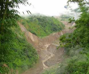
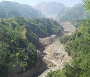
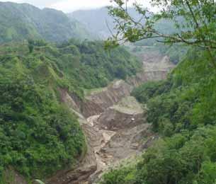
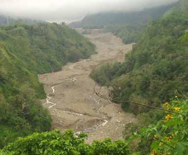
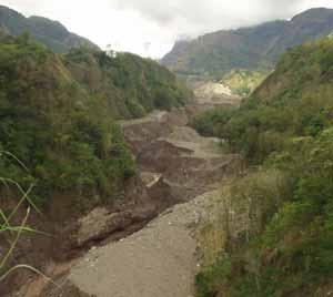
7 Collapsed Area (As of April 8, 2005) 2 1 a b a Photo A b Photo B Location Map Photo B Bili-Bili Reservoir 1 2 Photo A 7


8 After Collapse at Lengkese (March 26, 2005) Evacuation of Village People Buried Houses Buried Paddy Field (Parangkeke) 8
9 Development of Gully April 8, 2004 December 9, 2004 June 20, 2004 January 22, 2005 February 14, 2005 September 27,


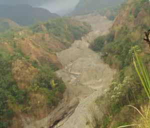
10 Damages Sand Pocket Dam No. 5 Before Collapse Debris Flow Jeneberang River Channel Paddy fields along the river were buried. The damage expands day by day. Bili-Bili Reservoir Sand Pocket Dam No. 5 The left abutment of SP No. 5 was completely buried by debris. At the downstream of SP No.5, village people start cultivating. March 26, 05 Evacuated Houses along the River (Bonto-Jai) March 26, 04 10


11 Damages Sedimentation of Bili-Bili Dam June 24, 04 Sedimentation at Upstream of the Bili-Bili Reservoir at present, the sediment volume is estimated at 10mil m3 while the design sediment volume is set at 29mil. m3. Aug 20, 05 Raw Water Turbidity at Somba-Op Water Purification Plant During rainy season in 04 to 05, the operation and supply water were stopped for 22days or 350hrs. in total due to the sediment content. 11


12 Damages River Structures Sand Pocket No. 4 June 24, 04 Before Collapse Daraha Bridge Daraha Bridge was flushed out by debris flow on 14 April Trans 13,000 village People has been affected. May 07, 05 April 17, 05 12
13 The Project Bawakaraeng Urgent Sediment Control Project 13
14 Objectives of the Project To protect public assets such as Bili-Bili dam and the farmlands and properties along the river; To mitigate the secondary disaster due to the debris flow, To realize sustainable Sabo works and sand management, and To improve the social welfare in the affected area. 14
15 Counter Measures Following countermeasures will be provided to achieve the objectives in accordance with the ISDM concept: Structural Measures - Construction of Sabo Dams; - Rehabilitation of existing structures (Road, bridge and Sand Pocket Dam No. 4); - Removal of River Deposit at Sand Pocket Dams and Bili-Bili Reservoir. Nonstructural Measures -Urgent inspection for prediction of further collapse and occurrence of debris flow; -Providing forecasting and warning system against the debris flow. 15
16 Sediment Control plan Sediment Balance up to Generated Sediment at Caldera 60,400,000 m 3 - Stored in Caldera by Sabo Dam 11,000,000 m 3 - Sediment Discharge from Caldera 49,400,000 m 3 - Deposit in River Channel 8,100,000 m 3 - Excavation in River 25,500,000 m 3 - Sedimentation in Bili-Bili Dam 7,900,000 m 3 - Flow down to the Downstream 7,900,000 m 3 Sedimentation in Bili-Bili Dam 7,900,000 m3 Flow down to the Downstream 7,900,000 m3 Excavation in River 25,500,000 m3 Deposit in River Channel 8,100,000 m3 Sediment Discharge from Caldera 49,400,000 m3 Generated Sediment at Caldera 60,400,000 m 3 Stored in Caldera by Sabo Dam 11,000,000 m3 Mt. Bawakaraeng 16

17 General Map of the Project 17
18 RG Collapsed Mountain Mt. Bawakaraeng RG Telemetry System for Monitoring & Warning of Debris Flow -4 Rain gauges - 1 Water Level Gauge Legend RG The Most Urgent Works Emergency Works Daraha Bridge Flashed away on April 17, 05 RG WL Sabo Dams for protection of sediment discharge from Caldera - 10 Sabo dams Construction - Total height 100 m Rain/Water Level Gauge (proposed) Sabo/Sand Pocket Dam (Proposed) Sabo/Sand Pocket Dam (Existing) SD No. 4 to be re-constructed for debris flow control Malino River Conservation of Buried Paddy Field as a regional development to relief the suffered people as well as to control sediment discharge - Groundsill & channel works - Irrigation system - Reclamation of land SP No. 5 SP No. 4 SP No. 3 Sediment Excavation at End of Reservoir & Sand Pocket Dams Excavation Volume 5 mil. m 3 /year for 5 years (1n 2006, applying NPTGA: Rp31M from 2007, JBIC Loan) SP No. 2 SP No. 1 Dredging Works to recover the effective storage of the Bili- Bili Reservoir (details are under study) Spoil Bank at Site of Quarry (beside the Spillway) Rehabilitation of Sand Pocket Dam No. 4 Bawakaraeng Urgent Sediment Control Project EL. 61 m Bili-Bili Dam 18 EL. 59 m
19 Sabo Dam Plan: Profile 1,150 1,100 Layout of Sabo Dams (Longitudinal Profile) SD ,050 SD 7-9 SD 7-8 Elevation (EL. m) 1, SD 7-1 SD 7-2 SD 7-3 SD 7-4 SD 7-6 SD 7-5 SD Lengkese 850 Surface of Debris (EL. m) 800 Bottom of Gully (EL. m) Design Slope (EL. m) , , , , , , , , ,700.0 Distance (m) 19
20 Sabo Dam Plan: Plan Jene Berang Parangkeke Kec. Tinggimoncong Kab. Gowa Paragang Jeneberang River 20
21 The Most Urgent Components Selection Concepts For the early implementation of the works, the Consultant was selected under direct appointment. But the scope of works were limited to the Most Urgent Components which were selected in accordance with following concepts: The works will affect the peoples lives and their daily activities. The works related to the sediment control and must be conducted within this year to catch up the proposed schedule. 21
22 Scope of Works the Most Urgent Components (1) Study Components Urgent Investigations (Data Collection, Survey for Further Collapse); Preparation of hazard map and monitoring, warning and evacuation systems; Periodical survey of river and reservoir and its analysis; (2) Environmental and Regional Development Components Establishment of PAFs Participatory Process to the Project; Environmental Monitoring; (3) Structural Components Excavation of Riverbed Deposit to be conducted in 2005 and 2006; Construction of Series of Sabo Dams No. 7 to be constructed in 2005 and 2006; Establishment of Telemetry System; 22
23 Proposed Additional Works Works should be conducted immediately - Design of Daraha Bridge. - Rehabilitation of Sand Pocket Dam No Sediment Flashing for Bili-Bili Dam. Works to be conducted in Stage II - Succeeding works of MUC - Construction of Daraha Bridge - Regional Development Works to be conducted in future - Reservoir Sedimentation Control Measures. - Surface Water Intake System. - Watershed Management Plan of the JRB. 23
24 Proposed Additional Works Proposed Additional Sediment Control Measures In the Caldera - Hillside Works - Reforestation At the Reservoir - Drainage of Natural Dams -Dredging - Sediment Trap & Bypass Tunnel - Selective Water Intake Mt. Bawakaraeng Along the Middle Section Along the Upstream Section - Riverbed Excavation at Sand Pockets -Sand Mining - Sabo Dams - Channel Works - Groundsills - Channel Works 24
25 Implementation Schedule E/S for MUC/Stage II 1. Riverbed Excavation Works 2. Sabo Dams Construction 3. Establishment of Telemetry System 4. Daraha Bridge Construction 5. Rehabilitation of Structures 6. Regional Development Works 7. Environmental Monitoring 8. Urgent Survey/Long Term Plan 9. Sabo Community Support 04 Under APBN Collapse (Mar. 04) Appraisal (Oct. 04) Pledge (Jan. 05) L/A (mar. 04) MUC Urgent Survey Stage II Up to 2012 Long Term Plan 25
26 Present Activities Construction Works Construction of Sabo Dam No Design Dec Tender May -Jul Construction Jul Oct Telecommunication System - Design Jun. - August Tender Sep. - Dec Construction Jan. -Oct
27 Present Activities Urgent Survey Starting from June 2005 Site Investigation in & around the Caldera. Data Collection - Related Reports/Topographic Maps - Rainfall Data from DCO/DINAS; - Turbidity of Raw Water from PDAM & PLN; - Debris Flow & Rainfall records from Sabo Communities. Evaluation of Collapse Mass & Sediment Movement through Map/Aerial Photo Readings. Geological Evaluation -Geological - Verification of Mechanism of the Collapse; - Evaluation of further collapse. 27
28 Present Activities Subcontract Works Topographic Survey - Aerial photo & Ortho-photo mapping - River Cross-sectional Survey - Reservoir echo-sounding - Topographic survey at Daraha Bridge Material & Geological Investigation - Riverbed Material Survey - CSG & ISM Trial Mix. - Geological Survey at Daraha Bridge The environmental monitoring for the construction works Assistance works of the activities of Sabo Communities in Jeneberang 28


29 Activities of Sabo Community Monitoring of Sediment Movement and Debris Flow. Monitoring of Rainfall at Panaikang. Public Awareness of Sediment Disaster. - Preparation of Hazard Map applying the PRA Process; - Establishment of Evacuation Center; - Indication of Hazardous Zone; - Emergency Drill of Warning & Evacuation. Support of Local Economic Activities. - Training of Production of Concrete Pavement Block; - Nourish of young trees, etc.; 29

30 The End 30
SEDIMENT TRANSPORT ANALYSIS FOR SECURING WATER (CASE STUDY : UPPER JENEBERANG RIVER)
") : Integrated Solution to Overcome the Climate Change Impact on Coastal Area Semarang, Indonesia November 19th, 2015 Paper No. A-I-069 SEDIMENT TRANSPORT ANALYSIS FOR SECURING WATER (CASE STUDY : UPPER
: Integrated Solution to Overcome the Climate Change Impact on Coastal Area Semarang, Indonesia November 19th, 2015 Paper No. A-I-069 SEDIMENT TRANSPORT ANALYSIS FOR SECURING WATER (CASE STUDY : UPPER
DEBRIS FLOW DISASTER MITIGATION THROUGH COMMUNITY-BASED INTEGRATED SEDIMENT MANAGEMENT (BEST PRACTICE IN MT. MERAPI AREA, INDONESIA)
") Civil Engineering Forum Volume XXI/3 - September 2012 DEBRIS FLOW DISASTER MITIGATION THROUGH COMMUNITY-BASED INTEGRATED SEDIMENT MANAGEMENT (BEST PRACTICE IN MT. MERAPI AREA, INDONESIA) K. Otani Yachiyo
Civil Engineering Forum Volume XXI/3 - September 2012 DEBRIS FLOW DISASTER MITIGATION THROUGH COMMUNITY-BASED INTEGRATED SEDIMENT MANAGEMENT (BEST PRACTICE IN MT. MERAPI AREA, INDONESIA) K. Otani Yachiyo
EXPERIMENTAL STUDY OF FLOW IMPACT AT SAND POCKET
 EXPERIMENTAL STUDY OF FLOW IMPACT AT SAND POCKET Melly Lukman, Ssleh Pallu, Arsyad Thaha and Farouk Maricar Civil Engineering Study Program, Hasanuddin University, Indonesia E-Mail: novi_wre@yahoo.co.id
Sedimentation in the Nile River
 Advanced Training Workshop on Reservoir Sedimentation Sedimentation in the Nile River Prof. Dr. Abdalla Abdelsalam Ahmed 10-16 Oct. 2007, IRTCES, Beijing, China CWR,Sudan 1 Water is essential for mankind
2. PRESENT CONDITION OF THE RESERVOIR 2.1 View of Wonogiri Reservoir (1/3)
") 2.1 View of Wonogiri Reservoir (1/3) Wonogiri dam abutment on the left side of dam Spillway forebay on thet left side of dam Bank erosion around Wonogiri reservoir. Wonogiri Dam view from chersonese. An
2.1 View of Wonogiri Reservoir (1/3) Wonogiri dam abutment on the left side of dam Spillway forebay on thet left side of dam Bank erosion around Wonogiri reservoir. Wonogiri Dam view from chersonese. An
The Application of Sabo Technology for Lahars Flood Mitigation and Warning System in Volcanic Area. Agus Sumaryono Bambang Sukatja F.
 The Application of Sabo Technology for Lahars Flood Mitigation and Warning System in Volcanic Area Agus Sumaryono Bambang Sukatja F. Tata Yunita BACKGROUND The Indonesia Government has constructed several
3/3/2013. The hydro cycle water returns from the sea. All "toilet to tap." Introduction to Environmental Geology, 5e
 Introduction to Environmental Geology, 5e Running Water: summary in haiku form Edward A. Keller Chapter 9 Rivers and Flooding Lecture Presentation prepared by X. Mara Chen, Salisbury University The hydro
Ayubowan. Management (CBDRM) Community Based Disaster Risk. Towards Disaster Resilient Community Developed by Disaster Management Centre,
 Community Based Disaster Risk. Towards Disaster Resilient Community Developed by Disaster Management Centre,") Ayubowan Community Based Disaster Risk Management (CBDRM) Towards Disaster Resilient Community 5-20 Purpose of this activity To know the risks in community to prepare for future disasters To exchange knowledge
Ayubowan Community Based Disaster Risk Management (CBDRM) Towards Disaster Resilient Community 5-20 Purpose of this activity To know the risks in community to prepare for future disasters To exchange knowledge
The sketch map of field investigations in Wenchuan earthquake hit region, Chengdu City.
 The sketch map of field investigations in Wenchuan earthquake hit region, Chengdu City. 1 Environmental and Geological Condition 1.1 Geomorphology BaiSha River Basin is located in Dujiangyan County, and
National Hydrology committee of Afghanistan (NHCA) Sedimentation in Reservoire
 Sedimentation in Reservoire") National Hydrology committee of Afghanistan (NHCA) Sedimentation in Reservoire OCt.2007 Prof. Mohammad Qasem Seddeqy KPU بسم االله الرحمن الرحيم وجعلنامن الماءکل شي ء حی 30 واز ا ب هر چيزی رازنده گردانيدیم
National Hydrology committee of Afghanistan (NHCA) Sedimentation in Reservoire OCt.2007 Prof. Mohammad Qasem Seddeqy KPU بسم االله الرحمن الرحيم وجعلنامن الماءکل شي ء حی 30 واز ا ب هر چيزی رازنده گردانيدیم
Stream Geomorphology. Leslie A. Morrissey UVM July 25, 2012
 Stream Geomorphology Leslie A. Morrissey UVM July 25, 2012 What Functions do Healthy Streams Provide? Flood mitigation Water supply Water quality Sediment storage and transport Habitat Recreation Transportation
Internationales Symposion INTERPRAEVENT 2004 RIVA / TRIENT
 APPLICATION TO PAST DISASTERS OF A METHOD OF SETTING APPLICATION THE RANGE TO OF PAST DEBRIS DISASTERS FLOW OF DAMAGE A METHOD TO HOUSES OF SETTING THE RANGE OF DEBRIS FLOW DAMAGE TO HOUSES Hideaki Mizuno
CHALLENGES ON SEDIMENT- RELATED DISASTER MITIGATION
 CHALLENGES ON SEDIMENT- RELATED DISASTER MITIGATION Dolores M. Hipolito Project Manager II DPWH, PMO-FCSEC Types of Sediment-Related Disasters A. Direct Disaster Debris flows Landslides Slope failures
GENERAL. CHAPTER 1 BACKGROUND AND PURPOSE OF THE GUIDELINES Background of the Guidelines Purpose of the Guidelines...
 GENERAL CHAPTER 1 BACKGROUND AND PURPOSE OF THE GUIDELINES... 1 1.1 Background of the Guidelines... 1 1.2 Purpose of the Guidelines... 3 CHAPTER 2 APPLICATION OF THE GUIDELINES... 3 2.1 Potential Users
Landslide Disaster Management in Sri Lanka and Nichola Oya as a Case study. Group 16 Gamini Jayathissa Udeni Nawagamuwa
 Landslide Disaster Management in Sri Lanka and Nichola Oya as a Case study Group 16 Gamini Jayathissa Udeni Nawagamuwa Taiwan Sri lanka >2582 mm, max >5000mm NE= Nov. to Feb 1750 2500 mm >2500 mm Central
A Roundup of Recent Debris Flow Events in Taiwan
 2015 International Workshop on Typhoon and Flood APEC Experience Sharing on Hazardous Weather Events and Risk Management A Roundup of Recent Debris Flow Events in Taiwan Hsiao-Yuan(Samuel) Yin Ph.D. sammya@mail.swcb.gov.tw
Gigantic collapse of the Caldera wall of Mt. Bawakaraeng (2,830 m) in March 2004 had supplied the
 in March 2004 had supplied the") COMMUNITY BASED WARNING AND EVACUATION SYSTEM AGAINST DEBRIS FLOW IN THE UPPER JENEBERANG RIVER, GOWA, SOUTH SULAWESI Sutikno Hardjosuwarno Experimantal Station for Sabo, Research Center for Water Resources
COMMUNITY BASED WARNING AND EVACUATION SYSTEM AGAINST DEBRIS FLOW IN THE UPPER JENEBERANG RIVER, GOWA, SOUTH SULAWESI Sutikno Hardjosuwarno Experimantal Station for Sabo, Research Center for Water Resources
Understanding disaster risk ~ Lessons from 2009 Typhoon Morakot, Southern Taiwan
 Understanding disaster risk ~ Lessons from 2009 Typhoon Morakot, Southern Taiwan Wen Chi Lai, Chjeng-Lun Shieh Disaster Prevention Research Center, National Cheng-Kung University 1. Introduction 08/10
REDWOOD VALLEY SUBAREA
 Independent Science Review Panel Conceptual Model of Watershed Hydrology, Surface Water and Groundwater Interactions and Stream Ecology for the Russian River Watershed Appendices A-1 APPENDIX A A-2 REDWOOD
Born in Unzen The World s First Unmanned Construction of Multilayer Sediment Control Dam Using Sediment Forms Unzen Restoration Project Office
 Born in Unzen The World s First Unmanned Construction of Multilayer Sediment Control Dam Using Sediment Forms Unzen Restoration Project Office Unzen Restoration Project Office Kyushu Regional Construction
Floods Lecture #21 20
 Floods 20 Lecture #21 What Is a Flood? Def: high discharge event along a river! Due to heavy rain or snow-melt During a flood, a river:! Erodes channel o Deeper & wider! Overflows channel o Deposits sediment
8 Current Issues and Research on Sediment Movement in the River Catchments of Japan
 8 Current Issues and Research on Sediment Movement in the River Catchments of Japan YUTAKA ICHIKAWA INTRODUCTION Prediction of sediment movement is one of the challenging tasks in water-related research.
Huong River. Serial No. : Viet Nam-8 Location: Thua Thien Hue Province, Viet Nam N 16 00' '
 Viet Nam 8 Huong River Map of River Table of Basic Data Name: Huong River Serial No. : Viet Nam-8 Location: Thua Thien Hue Province, Viet Nam N 16 00' - 14 40' E 107 07' - 107 50' 2 Area: 2,830 km Length
PRELIMINARY DRAFT FOR DISCUSSION PURPOSES
 Memorandum To: David Thompson From: John Haapala CC: Dan McDonald Bob Montgomery Date: February 24, 2003 File #: 1003551 Re: Lake Wenatchee Historic Water Levels, Operation Model, and Flood Operation This
Debris Flow in the Kitamatasawa Tributary of the Namekawa River in the Kiso River System
 Monitoring Note Debris Flow in the Kitamatasawa Tributary of the Namekawa River in the Kiso River System Toshiharu ARISAWA 1 and Yutaka SUZUKI 2 1 Tajimi Office of Sabo and National Highwey,Chubu Regional
Debris flow: categories, characteristics, hazard assessment, mitigation measures. Hariklia D. SKILODIMOU, George D. BATHRELLOS
 Debris flow: categories, characteristics, hazard assessment, mitigation measures Hariklia D. SKILODIMOU, George D. BATHRELLOS Natural hazards: physical phenomena, active in geological time capable of producing
ENGINEERING HYDROLOGY
 ENGINEERING HYDROLOGY Prof. Rajesh Bhagat Asst. Professor Civil Engineering Department Yeshwantrao Chavan College Of Engineering Nagpur B. E. (Civil Engg.) M. Tech. (Enviro. Engg.) GCOE, Amravati VNIT,
CASE STUDY BINGA, PHILIPPINES
 SEDIMENT MANAGEMENT CASE STUDY BINGA, PHILIPPINES Key project features Name: Binga Country: Philippines Category: modify operating rule (focus or redistribute sediment); adaptive strategies Reservoir volume
Controlling Processes That Change Land
 1 Name Date Controlling Processes That Change Land People try to control some of the processes that change land. To do this, people apply technology- the use of science to solve problems in everyday life.
Promoting Rainwater Harvesting in Caribbean Small Island Developing States Water Availability Mapping for Grenada Preliminary findings
 Promoting Rainwater Harvesting in Caribbean Small Island Developing States Water Availability Mapping for Grenada Preliminary findings National Workshop Pilot Project funded by The United Nations Environment
EFFECT OF SAND MINING ACTIVITY ON THE SEDIMENT CONTROL SYSTEM (A CASE STUDY OF SOMBE-LEWARA RIVER, DONGGALA, INDONESIA)
") Civil Engineering Forum Volume XXI/1 - January 01 EFFECT OF SAND MINING ACTIVITY ON THE SEDIMENT CONTROL SYSTEM (A CASE STUDY OF SOMBE-LEWARA RIVER, DONGGALA, INDONESIA) Y. A. Bawias Agency of Public Works,
Civil Engineering Forum Volume XXI/1 - January 01 EFFECT OF SAND MINING ACTIVITY ON THE SEDIMENT CONTROL SYSTEM (A CASE STUDY OF SOMBE-LEWARA RIVER, DONGGALA, INDONESIA) Y. A. Bawias Agency of Public Works,
CASE STUDY BINGA, PHILIPPINES
 SEDIMENT MANAGEMENT CASE STUDY BINGA, PHILIPPINES Key project features Name: Binga Country: Philippines Category: modify operating rule (focus or redistribute sediment); adaptive strategies Binga hydropower
RESERVOIR SEDIMENTATION MANAGEMENT WITH BYPASS TUNNELS IN JAPAN. Keywords: Reservoir sedimentation, Sediment bypass, Diversion tunnel, Abrasion damage
 Proceedings of the Ninth International Symposium on River Sedimentation October 18 21, 2004, Yichang, China RESERVOIR SEDIMENTATION MANAGEMENT WITH BYPASS TUNNELS IN JAPAN Tetsuya SUMI Graduate School
WHEN IS IT EVER GOING TO RAIN? Table of Average Annual Rainfall and Rainfall For Selected Arizona Cities
 WHEN IS IT EVER GOING TO RAIN? Table of Average Annual Rainfall and 2001-2002 Rainfall For Selected Arizona Cities Phoenix Tucson Flagstaff Avg. 2001-2002 Avg. 2001-2002 Avg. 2001-2002 October 0.7 0.0
Strategies for managing sediment in dams. Iwona Conlan Consultant to IKMP, MRCS
 Strategies for managing sediment in dams Iwona Conlan Consultant to IKMP, MRCS 1 Sediment trapping by dams Active storage capacity Dead storage coarse material (bed load) Fine materials (suspension) Francis
CHANGES OF RUNOFF MECHANISM OF THE BRANTAS RIVER OVER THE PAST 30 YEARS
 CHANGES OF RUNOFF MECHANISM OF THE BRANTAS RIVER OVER THE PAST 30 YEARS TOSHIKATSU OMACHI Infrastructure Development Institute KATUMI MUSIAKE Fukushima University The Brantas River in the East Java originates
GUIDELINES FOR CONSTRUCTION TECHNOLOGY TRANSFER DEVELOPMENT OF WARNING AND EVACUATION SYSTEM AGAINST SEDIMENT DISASTERS IN DEVELOPING COUNTRIES
 GUIDELINES FOR CONSTRUCTION TECHNOLOGY TRANSFER DEVELOPMENT OF WARNING AND EVACUATION SYSTEM AGAINST SEDIMENT DISASTERS IN DEVELOPING COUNTRIES MARCH 2004 Ministry of Land, Infrastructure and Transport
EFFECT OF TWO SUCCESIVE CHECK DAMS ON DEBRIS FLOW DEPOSITION
 DOI: 10.4408/IJEGE.2011-03.B-116 EFFECT OF TWO SUCCESIVE CHECK DAMS ON DEBRIS FLOW DEPOSITION Farouk Maricar (*), Haruyuki Hashimoto (*), Shinya Ikematsu (*) & Tomohiro Miyoshi (*) (*) Department of Civil
APPENDIX-VI Sabo/ Flood Control Structural Measures
 The Study on Sabo and Flood Control for Western River Basins of Mount Pinatubo in the Republic of the Philippines Final Report Supporting Report APPENDIX-VI Sabo/ Flood Control Structural Measures THE
Tarbela Dam in Pakistan. Case study of reservoir sedimentation
 Tarbela Dam in Pakistan. HR Wallingford, Wallingford, UK Published in the proceedings of River Flow 2012, 5-7 September 2012 Abstract Reservoir sedimentation is a main concern in the Tarbela reservoir
Term Knowledge Using and applying Grade Criteria Autumn 1 Assessment window October Natural hazards pose major risks to people and property.
 Assessment Schedule Year 9 2015/6 Term Knowledge Using and applying Grade Criteria Autumn 1 Assessment window October 2015 3.1.1.2 Tectonic Natural hazards pose major risks to people and property. Definition
GIS Application in Landslide Hazard Analysis An Example from the Shihmen Reservoir Catchment Area in Northern Taiwan
 GIS Application in Landslide Hazard Analysis An Example from the Shihmen Reservoir Catchment Area in Northern Taiwan Chyi-Tyi Lee Institute of Applied Geology, National Central University, No.300, Jungda
Debris flow hazard mapping with a random walk model in Korea
 Risk Analysis VII PI-627 Debris flow hazard mapping with a random walk model in Korea H.-J. Youn, C.-W. Lee & C.-S. Woo Korea Forest Research Institute, Korea Abstract Recently, the sediment-related disasters,
Analysis of Sedimentation in Wonogiri Reservoir
 Journal of the Civil Engineering Forum Vol. 2 No. 1 (January 2016) Analysis of Sedimentation in Wonogiri Reservoir Tri Joko Inti Budi Santosa Large River Basin Organization of Bengawan Solo, Surakarta,
The Effects of Hydraulic Structures on Streams Prone to Bank Erosion in an Intense Flood Event: A Case Study from Eastern Hokkaido
 Symposium Proceedings of the INTERPRAENENT 2018 in the Pacific Rim The Effects of Hydraulic Structures on Streams Prone to Bank Erosion in an Intense Flood Event: A Case Study from Eastern Hokkaido Daisuke
A Numerical Method for Determine the Dredging Requirements for Channel Restoration Using Alishan Creek in Central Taiwan as an Example
 A Numerical Method for Determine the Dredging Requirements for Channel Restoration Using Alishan Creek in Central Taiwan as an Example Instructors : Dr. Jie-Dar Cheng Dr. Honglay Chen Dr. Chao-Yuan Lin
Session: For more information:
 Session: For more information: www.hydropower.org/congress San Juan, Puerto Rico www.glmengineers.com 2015 World Hydropower Congress Sustainable Sediment Management and Hydropower Reservoirs 21 May 2015
Figure 1. Which part of the river is labelled in Figure 1? a) Mouth b) Source c) Lower course d) channel
 Mouth b) Source c) Lower course d) channel") Rivers 1. Study Figure 1 showing the long profile of a river Figure 1 A Which part of the river is labelled in Figure 1? a) Mouth b) Source c) Lower course d) channel (1 mark) 2. Complete the sentences
Rivers 1. Study Figure 1 showing the long profile of a river Figure 1 A Which part of the river is labelled in Figure 1? a) Mouth b) Source c) Lower course d) channel (1 mark) 2. Complete the sentences
Proposal to limit Namakan Lake to 1970 Upper Rule Curve for remainder of summer
 July 7, 214 Subject: Proposal to limit Namakan Lake to 197 Upper Rule Curve for remainder of summer Background: Flooding in 214 has resulted in the highest water levels on Namakan Lake since 1968, and
Project (Project No. US-CA-62-2) Maintenance Inspection and Reports (Subtask 14.1) Inspection Report No.2
 Maintenance Inspection and Reports (Subtask 14.1) Inspection Report No.2") MEMORANDUM TO: FROM: Jim Well, Ducks Unlimited Mike Harvey, PhD, PG SUBJECT: M&T/ Llano Seco Fish Screen Project (Project No. US-CA-62-2) Maintenance Inspection and Reports (Subtask 14.1) Inspection Report
MEMORANDUM TO: FROM: Jim Well, Ducks Unlimited Mike Harvey, PhD, PG SUBJECT: M&T/ Llano Seco Fish Screen Project (Project No. US-CA-62-2) Maintenance Inspection and Reports (Subtask 14.1) Inspection Report
The SedAlp Project: WP6: INTERACTION WITH STRUCTURES
 The SedAlp Project: WP6: INTERACTION WITH STRUCTURES 6 th International conference Water in the Alps Herrenchiemsee, 12 th of October, 2016 Jošt Sodnik Contents Structure of SedAlp project (www.sedalp.eu)
VULNERABILITY OF WATER SUPPLY TO NATURAL HAZARDS IN JAMAICA
 VULNERABILITY OF WATER SUPPLY TO NATURAL HAZARDS IN JAMAICA RAFI AHMAD rafi.ahmad@uwimona.edu.jm Unit for disaster studies, Department of Geography & Geology, The University of the West Indies, Mona Kingston
The effectiveness of check dams in controlling upstream channel stability in northeastern Taiwan
 Erosion, Debris Mows and Environment in Mountain Regions (Proceedings of the Chengdu Symposium, July 1992). IAHS Publ. no. 209, 1992. 423 The effectiveness of check dams in controlling upstream channel
CASE STUDY NATHPA JHAKRI, INDIA
 SEDIMENT MANAGEMENT CASE STUDY NATHPA JHAKRI, INDIA Key project features Name: Nathpa Jhakri Country: India Category: reduce sediment production (watershed management); upstream sediment trapping; bypass
APPLICATION TO PAST DISASTERS OF A METHOD OF SETTING THE RANGE OF DEBRIS FLOW DAMAGE TO HOUSES
 APPLICATION TO PAST DISASTERS OF A METHOD OF SETTING THE RANGE OF DEBRIS FLOW DAMAGE TO HOUSES Hideaki MIZUNO Senior Researcher Erosion and Sediment Control National Institute for Land and Infrastructure
Subcommittee on Sedimentation Draft Sediment Analysis Guidelines for Dam Removal
 Subcommittee on Sedimentation Draft Sediment Analysis Guidelines for Dam Removal August 4, 2011 Jennifer Bountry, M.S., P.E. Tim Randle, M.S., P.E., D.WRE. Blair Greimann, Ph.D., P.E. Sedimentation and
SPECIFIC DEGRADATION AND RESERVOIR SEDIMENTATION. By Renee Vandermause & Chun-Yao Yang
 SPECIFIC DEGRADATION AND RESERVOIR SEDIMENTATION By Renee Vandermause & Chun-Yao Yang Outline Sediment Degradation - Erosion vs Sediment Yield - Sediment Yield - Methods for estimation - Defining Sediment
EIT-Japan Symposium 2011 on Human Security Engineering
 EIT-Japan Symposium 2011 on Human Security Engineering 2011 Disastrous Landslides at Khao Panom, Krabi, Thailand Suttisak Soralump Geotechnical Engineering Research and Development Center (GERD) Faculty
Unconventional Wisdom and the Effects of Dams on Downstream Coarse Sediment Supply. Byron Amerson, Jay Stallman, John Wooster, and Derek Booth
 Unconventional Wisdom and the Effects of Dams on Downstream Coarse Sediment Supply 3 February 2009 Byron Amerson, Jay Stallman, John Wooster, and Derek Booth Sultan River, WA OBJECTIVE Consider the landscape
FINAL REPORT VOLUME-VII PHOTO BOOK
 Directorate General of Water Resources Ministry of Public Works The Republic of Indonesia THE STUDY ON COUNTERMEASURES FOR SEDIMENTATION IN THE WONOGIRI MULTIPURPOSE DAM RESERVOIR IN THE REPUBLIC OF INDONESIA
Upgrading Feasibility Study on the Upper Seti Storage Hydroelectric Project in Nepal
 6.5 Evaporation Evaporation is measured at No. 815 meteorological station, EL. 5 m, in the Seti River basin. The average monthly evaporation from 1977 to 1997 is as shown in Table 6.5-1. Table 6.5-1 Average
4.17 Spain. Catalonia
 4.17 Spain Catalonia In Spain, inundation studies are the responsibility of the respective Hydrographic Confederations of each river basin (River Basin Authorities). The actual status of inundation studies
GEOMORPHIC CHANGES OF A LANDSLIDE DAM BY OVERTOPPING EROSION
 DOI: 10.4408/IJEGE.2011-03.B-087 GEOMORPHIC CHANGES OF A LANDSLIDE DAM BY OVERTOPPING EROSION K. Yoshino (*), T. Uchida (*), T. shimizu (*) & K. Tamura (*) (*) Incorporated Administrative Agency, Public
3.0 TECHNICAL FEASIBILITY
 3.0 TECHNICAL FEASIBILITY 3.1 INTRODUCTION To enable seasonal storage and release of water from Lake Wenatchee, an impoundment structure would need to be constructed on the lake outlet channel. The structure
Which map shows the stream drainage pattern that most likely formed on the surface of this volcano? A) B)
 B)") 1. When snow cover on the land melts, the water will most likely become surface runoff if the land surface is A) frozen B) porous C) grass covered D) unconsolidated gravel Base your answers to questions
1. When snow cover on the land melts, the water will most likely become surface runoff if the land surface is A) frozen B) porous C) grass covered D) unconsolidated gravel Base your answers to questions
Lecture 14: Floods. Key Questions
 Lecture 14: Floods Key Questions 1. What is an upstream flood? 2. What is a downstream flood? 3. What were the setup conditions that cause floods? 4. What is a 100-year flood? 5. How are 100-year flood
The Huong River the nature, climate, hydro-meteorological issues and the AWCI demonstration project
 The Huong River the nature, climate, hydro-meteorological issues and the AWCI demonstration project 7th GEOSS AP Symposium, the AWCI parallel session May 27, 214, Tokyo National Centre for Hydro-Meteorological
Hazard Resilience Index (HRI) Earthquakes, Tsunamis, and Volcanoes
 Earthquakes, Tsunamis, and Volcanoes") Hazard Index (HRI) Earthquakes, Tsunamis, and Volcanoes Earthquakes Tsunamis Volcano-Ash Falls, Projectiles and Lateral Blasts, Pyroclastic Flows and Lava Flows Earthquakes, Tsunamis and Volcanoes Please
Hazard Index (HRI) Earthquakes, Tsunamis, and Volcanoes Earthquakes Tsunamis Volcano-Ash Falls, Projectiles and Lateral Blasts, Pyroclastic Flows and Lava Flows Earthquakes, Tsunamis and Volcanoes Please
Role of Hydro-Met Services in Disaster Risk Management
 Role of Hydro-Met Services in Disaster Risk Management Tshewang Rigzin (Mr) National Centre for Hydrology and Meteorology, Bhutan 30 th November 2017 Outline Vision and Mission Functions related to Disaster
In Issue of International Sabo News Letter
 In Issue of International Sabo News Letter I had an opportunity to make a keynote speech on March 18 2003 at the session on Sedimentrelated Issues at the 3rd World Water Forum held in (Kyoto) Japan. Chairing
(Specification B) 40352H (JUN H01) General Certificate of Secondary Education Higher Tier June 2011 TOTAL. Time allowed 1 hour
 40352H (JUN H01) General Certificate of Secondary Education Higher Tier June 2011 TOTAL. Time allowed 1 hour") Centre Number Surname Candidate Number For Examiner s Use Other Names Candidate Signature Examiner s Initials Geography (Specification B) Unit 2 Hostile World Friday 17 June 2011 For this paper you must
Centre Number Surname Candidate Number For Examiner s Use Other Names Candidate Signature Examiner s Initials Geography (Specification B) Unit 2 Hostile World Friday 17 June 2011 For this paper you must
Geostatistical Analysis of Rainfall Temperature and Evaporation Data of Owerri for Ten Years
 Atmospheric and Climate Sciences, 2012, 2, 196-205 http://dx.doi.org/10.4236/acs.2012.22020 Published Online April 2012 (http://www.scirp.org/journal/acs) Geostatistical Analysis of Rainfall Temperature
Attachment B to Technical Memorandum No.2. Operations Plan of Ross Valley Detention Basins
 Attachment B to Technical Memorandum No.2 Operations Plan of Ross Valley Detention Basins Operations Plan of Ross Valley Detention Basins Stetson Engineers Inc. January 26, 2011 1.0 Introduction Achieving
TWO LARGE-SCALE LANDSLIDE DAMS AND OUTBURST DISASTER IN THE SHINANO RIVER, CENTRAL JAPAN
 TWO LARGE-SCALE LANDSLIDE DAMS AND OUTBURST DISASTER IN THE SHINANO RIVER, CENTRAL JAPAN Kimio Inoue 1, Toshio Mori 2 & Takahisa Mizuyama 3 ABSTRACT Large landslides or debris flows due to heavy rainfall,
Theme 4. Disaster Mitigation and Risk Management
 Theme 4 Disaster Mitigation and Risk Management World Flood Map in 2002 Released by WMO as of August 29 Over 17 million were affected (in more than 80 countries) 3,000 were killed Total damage of over
The World Bank BiH Floods Emergency Recovery Project (P151157)
") EUROPE AND CENTRAL ASIA Bosnia and Herzegovina Social, Urban, Rural and Resilience Global Practice Global Practice IBRD/IDA Investment Project Financing FY 2014 Seq No: 4 ARCHIVED on 22-Jun-2016 ISR22737
EUROPE AND CENTRAL ASIA Bosnia and Herzegovina Social, Urban, Rural and Resilience Global Practice Global Practice IBRD/IDA Investment Project Financing FY 2014 Seq No: 4 ARCHIVED on 22-Jun-2016 ISR22737
Chiang Rai Province CC Threat overview AAS1109 Mekong ARCC
 Chiang Rai Province CC Threat overview AAS1109 Mekong ARCC This threat overview relies on projections of future climate change in the Mekong Basin for the period 2045-2069 compared to a baseline of 1980-2005.
Level 1/Level 2 Certificate Specimen Paper
 Centre Number Surname Other Names Candidate Number For Examiner s Use Examiner s Initials Candidate Signature Geography 8031/1 Dynamic Physical World For this paper you must have: the colour insert (enclosed).
Fenhe (Fen He) Map of River. Table of Basic Data. China 10
 Map of River. Table of Basic Data. China 10") Fenhe (Fen He) Map of River Table of Basic Data Name(s): Fenhe (in Huanghe River) Location: Shanxi Province, Northern China Area: 39,471 km 2 Origin: Mt. Guancen (2,147 m) Outlet: Huanghe Serial No. :
Fenhe (Fen He) Map of River Table of Basic Data Name(s): Fenhe (in Huanghe River) Location: Shanxi Province, Northern China Area: 39,471 km 2 Origin: Mt. Guancen (2,147 m) Outlet: Huanghe Serial No. :
Hydro-engineers.ch HEC-RAS ANALAYSIS. River: L Aïre Mesfin Tewolde. Hydro-engineers.ch 23 oct. 2017
 Hydro-engineers.ch HEC-RAS ANALAYSIS River: L Aïre Mesfin Tewolde 17 Hydro-engineers.ch 23 oct. 2017 PREPARED BY MESFIN TEWOLDE [TEMPORARY MISSION] Hydro-engineers.ch HEC-RAS ANALYSIS [January- March 2014]
ISO Lead Auditor Lean Six Sigma PMP Business Process Improvement Enterprise Risk Management IT Sales Training
 Training Calendar 2014 Public s (ISO LSS PMP BPI ERM IT Sales Training) www.excelledia.com (ISO, LSS, PMP, BPI, ERM, IT, Sales Public s) 1 Schedule Registration JANUARY FEBRUARY 2 days 26 JAN 27 JAN 3
COUNTRY PRESENTATION ON MR JAYNAL ABEDIN JOINT SECRETARY ( WORKS & DEVELOPMENT ) MINISTRY OF DEFENCE
 MINISTRY OF DEFENCE") COUNTRY PRESENTATION ON By MR JAYNAL ABEDIN JOINT SECRETARY ( WORKS & DEVELOPMENT ) MINISTRY OF DEFENCE Bangladesh Geographical Location of Bangladesh Bangladesh Country at a Glance Physical Features 1,230
COUNTRY PRESENTATION ON By MR JAYNAL ABEDIN JOINT SECRETARY ( WORKS & DEVELOPMENT ) MINISTRY OF DEFENCE Bangladesh Geographical Location of Bangladesh Bangladesh Country at a Glance Physical Features 1,230
Changing Hydrology under a Changing Climate for a Coastal Plain Watershed
 Changing Hydrology under a Changing Climate for a Coastal Plain Watershed David Bosch USDA-ARS, Tifton, GA Jeff Arnold ARS Temple, TX and Peter Allen Baylor University, TX SEWRU Objectives 1. Project changes
Local Flood Hazards. Click here for Real-time River Information
 Local Flood Hazards Floods of the White River and Killbuck Creek are caused by runoff from general, and/or intense rainfall. Other areas of flooding concern are from the Boland Ditch and Pittsford Ditch.
Final Presentation on Disaster Risk Management in Japan. Through ADRC V. R Programme. Main Findings and Action Plan:
 Final Presentation on Disaster Risk Management in Japan Through ADRC V. R Programme Main Findings and Action Plan: Problem/Hazard and Disaster in Japan Good Practiced on Disaster Risk Management in Japan
Drought in Southeast Colorado
 Drought in Southeast Colorado Nolan Doesken and Roger Pielke, Sr. Colorado Climate Center Prepared by Tara Green and Odie Bliss http://climate.atmos.colostate.edu 1 Historical Perspective on Drought Tourism
HYDROLOGIC AND WATER RESOURCES EVALUATIONS FOR SG. LUI WATERSHED
 HYDROLOGIC AND WATER RESOURCES EVALUATIONS FOR SG. LUI WATERSHED 1.0 Introduction The Sg. Lui watershed is the upper part of Langat River Basin, in the state of Selangor which located approximately 20
AN ASSESSMENT OF THE RELATIONSHIP BETWEEN RAINFALL AND LAKE VICTORIA LEVELS IN UGANDA
 AN ASSESSMENT OF THE RELATIONSHIP BETWEEN RAINFALL AND LAKE VICTORIA LEVELS IN UGANDA BY CATHERINE MULINDE BA (Environmental Management), PGD (Meteorology) Teaching Assistant Department of Geography, Meteorology
A distributed runoff model for flood prediction in ungauged basins
 Predictions in Ungauged Basins: PUB Kick-off (Proceedings of the PUB Kick-off meeting held in Brasilia, 2 22 November 22). IAHS Publ. 39, 27. 267 A distributed runoff model for flood prediction in ungauged
Stop 1: Marmot Dam Stop 1: Marmot Dam
 Stop 1: Marmot Dam Stop 1: Marmot Dam Following the removal of Marmot Dam in 2007, the fate of the reservoir sediments has been monitored through a series of surveys and sediment transport measurements.
A3 RIVER BASIN AND RIVER CHANNEL
 Part-A: Existing Conditions A3 RIVER BASIN AND RIVER CHANNEL A3.1 Basin The Limboto-Bolango-Bone (LBB) basin has a total catchment area of about 27 km 2 and is shaped rectangle extending about 1 km from
A Simple Procedure for Estimating Loss of Life from Dam Failure. Wayne J. Graham, P.E. 1
 A Simple Procedure for Estimating Loss of Life from Dam Failure Wayne J. Graham, P.E. 1 INTRODUCTION Evaluating the consequences resulting from a dam failure is an important and integral part of any dam
HYDRAULIC SIMULATION OF FLASH FLOOD AS TRIGGERED BY NATURAL DAM BREAK
 Civil Engineering Forum Volume XXII/1 - January 2013 HYDRAULIC SIMULATION OF FLASH FLOOD AS TRIGGERED BY NATURAL DAM BREAK Yanuar Tri Kurniawan Directorate General of Water Resources, Ministry of Public
Temperature and Sound Survey on Steep Tea Farm Area and Salt Pan Site
 Journal of Geological Resource and Engineering 6 (2018) 37-44 doi:10.17265/2328-2193/2018.01.006 D DAVID PUBLISHING Temperature and Sound Survey on Steep Tea Farm Area and Salt Pan Site Naomi Ando River
Stream Restoration and Environmental River Mechanics. Objectives. Pierre Y. Julien. 1. Peligre Dam in Haiti (deforestation)
") Stream Restoration and Environmental River Mechanics Pierre Y. Julien Malaysia 2004 Objectives Brief overview of environmental river mechanics and stream restoration: 1. Typical problems in environmental
Stream Restoration and Environmental River Mechanics Pierre Y. Julien Malaysia 2004 Objectives Brief overview of environmental river mechanics and stream restoration: 1. Typical problems in environmental
Flash flood disaster in Bayangol district, Ulaanbaatar
 Flash flood disaster in Bayangol district, Ulaanbaatar Advanced Training Workshop on Reservoir Sedimentation Management 10-16 October 2007. IRTCES, Beijing China Janchivdorj.L, Institute of Geoecology,MAS
Experimental Study on Effect of Houses on Debris-Flow Flooding and Deposition in Debris Flow Fan Areas
 DATA ACQUISITION AND MODELLING (MONITORING, PROCESSES, TECHNOLOGIES, MODELS) Experimental Study on Effect of Houses on Debris-Flow Flooding and Deposition in Debris Flow Fan Areas Kana Nakatani, Dr. 1
Kiribati Adaptation Phase III (LDCF) (P112615)
 (P112615)") Public Disclosure Authorized EAST ASIA AND PACIFIC Kiribati Social, Urban, Rural and Resilience Global Practice Global Practice Global Environment Project Specific Investment Loan FY 2012 Seq No: 10 ARCHIVED
Public Disclosure Authorized EAST ASIA AND PACIFIC Kiribati Social, Urban, Rural and Resilience Global Practice Global Practice Global Environment Project Specific Investment Loan FY 2012 Seq No: 10 ARCHIVED
FORECAST-BASED OPERATIONS AT FOLSOM DAM AND LAKE
 FORECAST-BASED OPERATIONS AT FOLSOM DAM AND LAKE 255 237 237 237 217 217 217 200 200 200 0 163 131 Bridging the Gap163Conference 255 0 132 255 0 163 122 The Dana on Mission Bay San Diego, CA January 28,
Use of Geospatial data for disaster managements
 Use of Geospatial data for disaster managements Source: http://alertsystemsgroup.com Instructor : Professor Dr. Yuji Murayama Teaching Assistant : Manjula Ranagalage What is GIS? A powerful set of tools