The Application of Sabo Technology for Lahars Flood Mitigation and Warning System in Volcanic Area. Agus Sumaryono Bambang Sukatja F.
|
|
|
- Geraldine Watts
- 5 years ago
- Views:
Transcription
1 The Application of Sabo Technology for Lahars Flood Mitigation and Warning System in Volcanic Area Agus Sumaryono Bambang Sukatja F. Tata Yunita


.")


2 BACKGROUND The Indonesia Government has constructed several sediment control structures along the lahars river and established warning and evacuation system in Mt. Merapi and Mt. Semeru. Indonesia is one of the countries which are rich of active volcanoes (129 active volcanoes). The activities volcanoes caused disaster such as loss of life and properties, damages of infrastructures and farmland, and also damages of hydraulic structure. The sediment control works have shown good results, on the other hands the warning and evacuation system showed insufficient result due to some reason.
3 SCOPE OF ACTIVITIES The existing sediment control structures, warning and evacuation system against lahars flood in: 1. Mt. Merapi Boyong River (upstream) Code River (downstream) 2. Mt. Semeru Mujur R Rejali R


4 The Eruption of Merapi Volcano in 1994 hundreds hectares of forest damaged, tens houses were destroyed, tens hectares of farmland were buried, 64 people and 10 cattle died. The eruption produced 4 million cubic meter of pyroclastic which was deposited on the south slope of Merapi Volcano.
5 Lahar Flow in Boyong & Code River After 1994 Merapi eruption, 80% of pyroclastic material deposited the upstream of Boyong R. In rainy season, the rain water mixed with sediment deposit and the mixture flow downward in the form of lahar flow. The dense populated area along Boyong and Code River are effected by lahars floods. It is needed to construct a series of sediment control structure and establish a forecasting and warning system along Boyong River.


6 Lahar Flood Control Works in Boyong & Code River The existing sediment control structures along Boyong and Code River: Check dams : 8 units Consolidation dams : 19 units Groundsills : 23 units Bed girdle : 6 units Revertments : m Training dikes : m The planned capasity of sediment control works is 2,827,300 m 3. The existing volume of sediment controled by the structures is 1,509,000 m 3.


7 BO-D5, Slit Type Check dam BO-D1, Convensional Type Checkdam BO-C12, Consolidation Dam

8 BO-GS2B, Groundsill BO-C10, Multi-function sabo dam
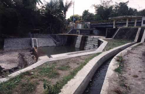
9 Lahars Flood Warning & Evacuation System in Boyong River The existing warning & evacuation system : Automatic Rain Gauge : 1 unit Lahars Flood Sensor : 1 unit Ultrasonic Water Level Gauge : 2 units Telemeter system : 1 unit


10 Automatic rain gauge in Kaliurang Telemeter System of Automatic Rain Gauge in Plawangan


11 Control Room of Telemeter System in Experimental Station for Sabo in Yogyakarta Automatic Water Level Gauge in Pulowatu


12 The operator was receiving warning signal for evacuating the people from vulnerable area Evacuation drill was done by local people.
13 Lahar Flood Disaster in Mt. Semeru Area Houses Destroyed (unit) Farmland Buried (Ha) People Died People Injured Forrest Burned (Ha)

14 Lahar Flood Countermeasure in Mt. Semeru Tawonsongo Gunungsawur 1. Structural : sediment control structures. Mujur Rejali Glidik Argosuko 2. Non Structural : lahar flood forecasting Warning & evacuation system Volcano observatory Evacuation Cam Evacuation Direction Possibility lahars over flow occurrence
15 Forecasting & Warning System in Semeru Volcanic Area No River Catchment ARG AWLG Lahar Sensor Radio Station Exist Add Exist Add Exist Add Exist Add 1 Mujur Rejali Glidik Note : ARG : Telemeter Automatic Rainfall Gauge AWLG : Telemeter Automatic Water Level Gauge Exist : Existing, Add : Additional


16 Telemeter System of Automatic Water Level Recorder in Besuk Koboan River Main Control Station of Lahars Warning System in Lumajang Non-telemeter Automatic Rain Gauge in Mujur River Catchment Area


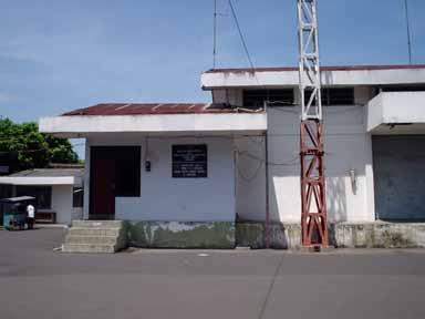
17 Radio and Siren Equipment at Station of Warning System Station of Lahars Warning System in Lumajang Main Station of Lahars Warning System in Lumajang
18 DISCUSSION 1. Lahar Flood Countermeasure in Boyong River, Mt. Merapi Area The number of sediment control structures is sufficient to control sediment discharge and to protect Yogyakarta City from lahar flood. The existing equipment for lahar forecasting and warning system is in good condition and can be operated well without any significant problem. 2. Lahar Flood Forecasting & Warning System in Mt. Semeru Area The early warning and evacuation system should be improved by installing additional warning equipment as well as the capacity of human resources. The evacuation routes and camps should be clearly designated. Evacuation drill should be carried out yearly.
19 CONCLUTION 1. The existing sediment control structures in Boyong River, Merapi Volcanic Area is sufficient to protect Yogyakarta city from lahar flood as well as to secure the inhabitant who live surrounding the river. 2. The existing forecasting and warning system along Boyong River can work well in order to send the information and warning to the local people who live in the vulnerable area. 3. The existing forecasting and warning system against Lahars flood in Semeru Volcanic Area should be developed in order to send the information and warning to the local people who live in the vulnerable area well.


20
EVALUATION ON THE IMPLEMENTATION OF EARLY WARNING SYSTEM FOR DEBRIS FLOW IN MERAPI AREA (CASE STUDY AT BOYONG RIVER)
") Journal of the Civil Engineering Forum Vol. 1 No. 3 (September 2015) EVALUATION ON THE IMPLEMENTATION OF EARLY WARNING SYSTEM FOR DEBRIS FLOW IN MERAPI AREA (CASE STUDY AT BOYONG RIVER) Ali Cahyadi Achmad
Journal of the Civil Engineering Forum Vol. 1 No. 3 (September 2015) EVALUATION ON THE IMPLEMENTATION OF EARLY WARNING SYSTEM FOR DEBRIS FLOW IN MERAPI AREA (CASE STUDY AT BOYONG RIVER) Ali Cahyadi Achmad
DEBRIS FLOW DISASTER MITIGATION THROUGH COMMUNITY-BASED INTEGRATED SEDIMENT MANAGEMENT (BEST PRACTICE IN MT. MERAPI AREA, INDONESIA)
") Civil Engineering Forum Volume XXI/3 - September 2012 DEBRIS FLOW DISASTER MITIGATION THROUGH COMMUNITY-BASED INTEGRATED SEDIMENT MANAGEMENT (BEST PRACTICE IN MT. MERAPI AREA, INDONESIA) K. Otani Yachiyo
Civil Engineering Forum Volume XXI/3 - September 2012 DEBRIS FLOW DISASTER MITIGATION THROUGH COMMUNITY-BASED INTEGRATED SEDIMENT MANAGEMENT (BEST PRACTICE IN MT. MERAPI AREA, INDONESIA) K. Otani Yachiyo
Debris flows and flash floods in the Putih River after the 2010 eruption of Mt. Merapi, Indonesia
 International Journal of Erosion Control Engineering Vol. 7, No. 2, 214 Original Article Debris flows and flash floods in the Putih River after the 21 eruption of Mt. Merapi, Indonesia 1 2 3 Yutaka GONDA,
GUIDELINES FOR CONSTRUCTION TECHNOLOGY TRANSFER DEVELOPMENT OF WARNING AND EVACUATION SYSTEM AGAINST SEDIMENT DISASTERS IN DEVELOPING COUNTRIES
 GUIDELINES FOR CONSTRUCTION TECHNOLOGY TRANSFER DEVELOPMENT OF WARNING AND EVACUATION SYSTEM AGAINST SEDIMENT DISASTERS IN DEVELOPING COUNTRIES MARCH 2004 Ministry of Land, Infrastructure and Transport
GENERAL. CHAPTER 1 BACKGROUND AND PURPOSE OF THE GUIDELINES Background of the Guidelines Purpose of the Guidelines...
 GENERAL CHAPTER 1 BACKGROUND AND PURPOSE OF THE GUIDELINES... 1 1.1 Background of the Guidelines... 1 1.2 Purpose of the Guidelines... 3 CHAPTER 2 APPLICATION OF THE GUIDELINES... 3 2.1 Potential Users
CONCEPT ON SUSTAINABLE SAND MINING MANAGEMENT IN MERAPI AREA
 CONCEPT ON SUSTAINABLE SAND MINING MANAGEMENT IN MERAPI AREA Jazaul IKHSAN 1, Masaharu FUJITA 2, Hiroshi TAKEBAYASHI 3 and Muhammad SULAIMAN 4 1 Member of JSCE, Graduate Student, Dept. of Civil and Earth
CHALLENGES ON SEDIMENT- RELATED DISASTER MITIGATION
 CHALLENGES ON SEDIMENT- RELATED DISASTER MITIGATION Dolores M. Hipolito Project Manager II DPWH, PMO-FCSEC Types of Sediment-Related Disasters A. Direct Disaster Debris flows Landslides Slope failures
Socio-Eco-Engineering-based Approach on Integrated Sediment Management in Mt. Merapi Area, Indonesia
 Socio-Eco-Engineering-based Approach on Integrated Sediment Management in Mt. Merapi Area, Indonesia Legono DJOKO, 1,* Katsuhiko OTANI 2, and Suharyanto 3 1 Civil and Environmental Engineering Department,
Nevado Del Ruiz, Lahars
 Nevado Del Ruiz, 1985 - Lahars Lecture Objectives -Basics of lahars: definition, characteristics -Ruiz case study: hazards, impacts Mt. Pinatubo lahar footage by Mike Dolan (MTU) Mt. Pinatubo lahar footage
Final Presentation on Disaster Risk Management in Japan. Through ADRC V. R Programme. Main Findings and Action Plan:
 Final Presentation on Disaster Risk Management in Japan Through ADRC V. R Programme Main Findings and Action Plan: Problem/Hazard and Disaster in Japan Good Practiced on Disaster Risk Management in Japan
A Roundup of Recent Debris Flow Events in Taiwan
 2015 International Workshop on Typhoon and Flood APEC Experience Sharing on Hazardous Weather Events and Risk Management A Roundup of Recent Debris Flow Events in Taiwan Hsiao-Yuan(Samuel) Yin Ph.D. sammya@mail.swcb.gov.tw
Universitas Gadjah Mada implements research, enhances knowledge, empowers society Join us to lead the way!
 SPIRIT OF MERAPI Universitas Gadjah Mada implements research, enhances knowledge, empowers society Join us to lead the way! UNIVERSITAS GADJAH MADA Yogyakarta, Indonesia SPIRIT OF MERAPI Field : Geography
LECTURE #11: Volcanoes: Monitoring & Mitigation
 GEOL 0820 Ramsey Natural Disasters Spring, 2018 LECTURE #11: Volcanoes: Monitoring & Mitigation Date: 15 February 2018 I. What is volcanic monitoring? the continuous collection of one or more data sources
Born in Unzen The World s First Unmanned Construction of Multilayer Sediment Control Dam Using Sediment Forms Unzen Restoration Project Office
 Born in Unzen The World s First Unmanned Construction of Multilayer Sediment Control Dam Using Sediment Forms Unzen Restoration Project Office Unzen Restoration Project Office Kyushu Regional Construction
Landslide Disaster Management in Sri Lanka and Nichola Oya as a Case study. Group 16 Gamini Jayathissa Udeni Nawagamuwa
 Landslide Disaster Management in Sri Lanka and Nichola Oya as a Case study Group 16 Gamini Jayathissa Udeni Nawagamuwa Taiwan Sri lanka >2582 mm, max >5000mm NE= Nov. to Feb 1750 2500 mm >2500 mm Central
The drag forces exerted by lahar flows on a cylindrical pier: case study of post Mount Merapi eruptions
 IOP Conference Series: Materials Science and Engineering PAPER OPEN ACCESS The drag forces exerted by lahar flows on a cylindrical pier: case study of post Mount Merapi eruptions To cite this article:
APPLICATION TO PAST DISASTERS OF A METHOD OF SETTING THE RANGE OF DEBRIS FLOW DAMAGE TO HOUSES
 APPLICATION TO PAST DISASTERS OF A METHOD OF SETTING THE RANGE OF DEBRIS FLOW DAMAGE TO HOUSES Hideaki MIZUNO Senior Researcher Erosion and Sediment Control National Institute for Land and Infrastructure
Rebuilding Flood-Conscious Society
 A zone where strong flood flow or river bank erosion by levee breach are anticipated, which likely to occur collapsing/washing away of house. Set up the joint councils by relative stakeholders(river managers,
Bawakaraeng Urgent Sediment Control Project
 Departmen Permukiman Umum Direktorat Jenderal Sumber Daya Air Bawakaraeng Urgent Sediment Control Project (The Most Urgent Components) August 2005 1 The Collapse On March 26, 2004, Mt. Sorongan (EL.2,541m)
EFFECT OF SAND MINING ACTIVITY ON THE SEDIMENT CONTROL SYSTEM (A CASE STUDY OF SOMBE-LEWARA RIVER, DONGGALA, INDONESIA)
") Civil Engineering Forum Volume XXI/1 - January 01 EFFECT OF SAND MINING ACTIVITY ON THE SEDIMENT CONTROL SYSTEM (A CASE STUDY OF SOMBE-LEWARA RIVER, DONGGALA, INDONESIA) Y. A. Bawias Agency of Public Works,
Civil Engineering Forum Volume XXI/1 - January 01 EFFECT OF SAND MINING ACTIVITY ON THE SEDIMENT CONTROL SYSTEM (A CASE STUDY OF SOMBE-LEWARA RIVER, DONGGALA, INDONESIA) Y. A. Bawias Agency of Public Works,
Progress Report. Flood Hazard Mapping in Thailand
 Progress Report Flood Hazard Mapping in Thailand Prepared By: Mr. PAITOON NAKTAE Chief of Safety Standard sub-beuro Disaster Prevention beuro Department of Disaster Prevention and Mitigation THAILAND E-mail:
Multiscalar Approach of Merapi Volcanic Erosion - Approche Multi Scalaire d Erosion de Volcan Merapi -
 Multiscalar Approach of Merapi Volcanic Erosion - Approche Multi Scalaire d Erosion de Volcan Merapi - Sandy Budi Wibowo PhD student at Univ. Paris 1 (N étudiant: 10928433) CDD Ingénieur d études (N agent
Understanding disaster risk ~ Lessons from 2009 Typhoon Morakot, Southern Taiwan
 Understanding disaster risk ~ Lessons from 2009 Typhoon Morakot, Southern Taiwan Wen Chi Lai, Chjeng-Lun Shieh Disaster Prevention Research Center, National Cheng-Kung University 1. Introduction 08/10
Hazard Resilience Index (HRI) Earthquakes, Tsunamis, and Volcanoes
 Earthquakes, Tsunamis, and Volcanoes") Hazard Index (HRI) Earthquakes, Tsunamis, and Volcanoes Earthquakes Tsunamis Volcano-Ash Falls, Projectiles and Lateral Blasts, Pyroclastic Flows and Lava Flows Earthquakes, Tsunamis and Volcanoes Please
Hazard Index (HRI) Earthquakes, Tsunamis, and Volcanoes Earthquakes Tsunamis Volcano-Ash Falls, Projectiles and Lateral Blasts, Pyroclastic Flows and Lava Flows Earthquakes, Tsunamis and Volcanoes Please
Use of Geospatial data for disaster managements
 Use of Geospatial data for disaster managements Source: http://alertsystemsgroup.com Instructor : Professor Dr. Yuji Murayama Teaching Assistant : Manjula Ranagalage What is GIS? A powerful set of tools
Mt. Merapi and Mt. Semeru Volcanic Disaster Countemesures Project(2)
") Indonesia Mt. Merapi and Mt. Semeru Volcanic Disaster Countemesures Project(2) Field Survey: July 2003 1. Project Outline and Japan s ODA Loan Mt. Merapi Mt. Semere Check dam on Mt. Merapi Project location
Indonesia Mt. Merapi and Mt. Semeru Volcanic Disaster Countemesures Project(2) Field Survey: July 2003 1. Project Outline and Japan s ODA Loan Mt. Merapi Mt. Semere Check dam on Mt. Merapi Project location
Risk Management Strategy
 Risk Management Strategy 1 Purpose To protect the component parts of the World Heritage property as well as the lives and the property of visitors and residents from disasters such as volcanic eruptions,
Floods Lecture #21 20
 Floods 20 Lecture #21 What Is a Flood? Def: high discharge event along a river! Due to heavy rain or snow-melt During a flood, a river:! Erodes channel o Deeper & wider! Overflows channel o Deposits sediment
Flash flood disaster in Bayangol district, Ulaanbaatar
 Flash flood disaster in Bayangol district, Ulaanbaatar Advanced Training Workshop on Reservoir Sedimentation Management 10-16 October 2007. IRTCES, Beijing China Janchivdorj.L, Institute of Geoecology,MAS
Flash Flood Guidance System On-going Enhancements
 Flash Flood Guidance System On-going Enhancements Hydrologic Research Center, USA Technical Developer SAOFFG Steering Committee Meeting 1 10-12 July 2017 Jakarta, INDONESIA Theresa M. Modrick Hansen, PhD
USING 3D GIS TO ASSESS ENVIRONMENTAL FLOOD HAZARDS IN MINA
 King Fahd University of Petroleum & Minerals College of Environmental Design Geographical Information system USING 3D GIS TO ASSESS ENVIRONMENTAL FLOOD HAZARDS IN MINA Prepared by : Ali AL-Zahrani OUTLINE
EFFECT OF TWO SUCCESIVE CHECK DAMS ON DEBRIS FLOW DEPOSITION
 DOI: 10.4408/IJEGE.2011-03.B-116 EFFECT OF TWO SUCCESIVE CHECK DAMS ON DEBRIS FLOW DEPOSITION Farouk Maricar (*), Haruyuki Hashimoto (*), Shinya Ikematsu (*) & Tomohiro Miyoshi (*) (*) Department of Civil
Volcanoes. volcanic hazards. Image courtesy of USGS.
 Volcanoes volcanic hazards Volcanic hazards Pyroclastic flows and surges Pyroclastic flows and surges PYROCLAST: all solid fragments ejected from volcanoes PYROCLASTIC FLOW: A flow of hot gas and volcanic
3/3/2013. The hydro cycle water returns from the sea. All "toilet to tap." Introduction to Environmental Geology, 5e
 Introduction to Environmental Geology, 5e Running Water: summary in haiku form Edward A. Keller Chapter 9 Rivers and Flooding Lecture Presentation prepared by X. Mara Chen, Salisbury University The hydro
CLIMATE CHANGE ADAPTATION BY MEANS OF PUBLIC PRIVATE PARTNERSHIP TO ESTABLISH EARLY WARNING SYSTEM
 CLIMATE CHANGE ADAPTATION BY MEANS OF PUBLIC PRIVATE PARTNERSHIP TO ESTABLISH EARLY WARNING SYSTEM By: Dr Mamadou Lamine BAH, National Director Direction Nationale de la Meteorologie (DNM), Guinea President,
Overview of Philippine Geohazards Programs
 Overview of Philippine Geohazards Programs 53 rd CCOP Annual Session CCOP-IUGS Task Group on Geohazards Joint Seminar Cebu City, PHILIPPINES October 18, 2017 Renato U. Solidum, Jr. Department of Science
Montserrat Eruption = Monster rat
 Montserrat Eruption 1997 = Monster rat Small island in the Caribbean sea Montserrat is a small... Soufriere Hills volcano Key facts: Date: 25 th June 1997 (small eruptions began in July 1995) Size: 4.5
LOCATIONS OF SELECTED MITIGATION SITES IN JAPAN
 LOCATIOS OF SELECTED MITIGATIO SITES I JAPA Hyogo prefecture near Kobe, Japan Hyogo province Gifu province Osaka Kobe Gifu prefecture near Takayama, Japan akao Kamikochi ational Park Mount Yake Tateyama
Internationales Symposion INTERPRAEVENT 2004 RIVA / TRIENT
 APPLICATION TO PAST DISASTERS OF A METHOD OF SETTING APPLICATION THE RANGE TO OF PAST DEBRIS DISASTERS FLOW OF DAMAGE A METHOD TO HOUSES OF SETTING THE RANGE OF DEBRIS FLOW DAMAGE TO HOUSES Hideaki Mizuno
Formulation of the Strategy for Disaster Risk Reduction and Emergency Preparedness and Response of the Asia-Pacific Region
 2008/SOM3/TFEP/SEM/006 Formulation of the Strategy for Disaster Risk Reduction and Emergency Preparedness and Response of the Asia-Pacific Region 2009-2015 Submitted by: Thailand Emergency Management CEOs
Sylvain Charbonnier. PASI Workshop About 60% of Indonesians live around 16 active volcanoes on the island of Java
 Numerical modelling of pyroclastic flows: a case study from the recent activity of Merapi Volcano, Central Java, Indonesia Sylvain Charbonnier PASI Workshop 2011 Case study: Merapi Volcano! About 60% of
Assessment of the catastrophic events originated in the river Vere basin
 Assessment of the catastrophic events originated in the river Vere basin Tbilisi, Georgia Presenter: Irakli Megrelidze Deputy Head of Hydrometeorological Department (National Environmental Agency) Hydrology
Role of Hydro-Met Services in Disaster Risk Management
 Role of Hydro-Met Services in Disaster Risk Management Tshewang Rigzin (Mr) National Centre for Hydrology and Meteorology, Bhutan 30 th November 2017 Outline Vision and Mission Functions related to Disaster
Guidance for GEOGRAPHY End of Year Examination 2016
 Guidance for GEOGRAPHY End of Year Examination 2016 The End of Year Examination takes place in Week 4 of the Summer Term. The Geography Examination will last 50 minutes. The Examination will include questions
Ayubowan. Management (CBDRM) Community Based Disaster Risk. Towards Disaster Resilient Community Developed by Disaster Management Centre,
 Community Based Disaster Risk. Towards Disaster Resilient Community Developed by Disaster Management Centre,") Ayubowan Community Based Disaster Risk Management (CBDRM) Towards Disaster Resilient Community 5-20 Purpose of this activity To know the risks in community to prepare for future disasters To exchange knowledge
Ayubowan Community Based Disaster Risk Management (CBDRM) Towards Disaster Resilient Community 5-20 Purpose of this activity To know the risks in community to prepare for future disasters To exchange knowledge
8 Current Issues and Research on Sediment Movement in the River Catchments of Japan
 8 Current Issues and Research on Sediment Movement in the River Catchments of Japan YUTAKA ICHIKAWA INTRODUCTION Prediction of sediment movement is one of the challenging tasks in water-related research.
Volcanoes. Environmental Geology, Mr. Paul Lowrey Stacey Singleton, Cassandra Combs, Dwight Stephenson, Matt Smithyman
 Volcanoes Environmental Geology, Mr. Paul Lowrey Stacey Singleton, Cassandra Combs, Dwight Stephenson, Matt Smithyman EMPACTS Project, Spring 2017 Northwest Arkansas Community College, Bentonville, AR
Prediction of landslide-induced debris flow hydrograph: the Atsumari debris flow disaster in Japan
 Monitoring, Simulation, Prevention and Remediation of Dense and Debris Flows 27 Prediction of landslide-induced debris flow hydrograph: the Atsumari debris flow disaster in Japan H. Takaoka 1, H. Hashimoto
The Effects of Hydraulic Structures on Streams Prone to Bank Erosion in an Intense Flood Event: A Case Study from Eastern Hokkaido
 Symposium Proceedings of the INTERPRAENENT 2018 in the Pacific Rim The Effects of Hydraulic Structures on Streams Prone to Bank Erosion in an Intense Flood Event: A Case Study from Eastern Hokkaido Daisuke
A distributed runoff model for flood prediction in ungauged basins
 Predictions in Ungauged Basins: PUB Kick-off (Proceedings of the PUB Kick-off meeting held in Brasilia, 2 22 November 22). IAHS Publ. 39, 27. 267 A distributed runoff model for flood prediction in ungauged
River Response. Sediment Water Wood. Confinement. Bank material. Channel morphology. Valley slope. Riparian vegetation.
 River Response River Response Sediment Water Wood Confinement Valley slope Channel morphology Bank material Flow obstructions Riparian vegetation climate catchment vegetation hydrological regime channel
DEBRIS FLOW MONITORING AND WARNING SYSTEMS: A NEW STUDY SITE IN THE ALPS
 DEBRIS FLOW MONITORING AND WARNING SYSTEMS: A NEW STUDY SITE IN THE ALPS Comiti F 1, Macconi P 2, Marchi L 3, Arattano M 4, Borga M 5, Brardinoni F 6, Cavalli M 3, D Agostino V 5, Hellweger S 3, Trevisani
Regional Flash Flood Guidance and Early Warning System
 WMO Training for Trainers Workshop on Integrated approach to flash flood and flood risk management 24-28 October 2010 Kathmandu, Nepal Regional Flash Flood Guidance and Early Warning System Dr. W. E. Grabs
HYDRAULIC SIMULATION OF FLASH FLOOD AS TRIGGERED BY NATURAL DAM BREAK
 Civil Engineering Forum Volume XXII/1 - January 2013 HYDRAULIC SIMULATION OF FLASH FLOOD AS TRIGGERED BY NATURAL DAM BREAK Yanuar Tri Kurniawan Directorate General of Water Resources, Ministry of Public
Attabad landslide crisis in Hunza, Pakistan lessons for the management of valley blocking landslides. Dave Petley
 Attabad landslide crisis in Hunza, Pakistan lessons for the management of valley blocking landslides Dave Petley Durham University, United Kingdom Thanks to: D. Karim, S. Wali, N. Ali, N. Nasab & K. Shaban
Proposal Report On Flood Hazards Mapping Project In Xebangfai River
 Proposal Report On Flood Hazards Mapping Project In Xebangfai River Prepared By Mr. Boualaythong KOUMPHONH Climate Division Department of Meteorology and Hydrology Water Resources and Environment Administration
Measures Also Significant Factors of Flood Disaster Reduction
 Non-Structual Measures Also Significant Factors of Flood Disaster Reduction Babiaková Gabriela, Leškov ková Danica Slovak Hydrometeorological Institute, Bratislava Hydrological Forecasts and Warning Department
Outline and Future Strategies of SABO Works in Japan. Koji Nishiyama
 Outline and Future Strategies of SABO Works in Japan Koji Nishiyama Director General Sabo Department, Ministry of Land, Infrastructure, Transport and Tourism -MLIT Japan Jun. 15th, 2017 The 10 th Japan-Italy
1. INTRODUCTION. EXAMPLE OF SECHILIENNE ROCKFALL (France)
") FORM OSE POST-GRADUATE COURSE Landslide vulnerability and risk 1 FORM OSE POST-GRADUATE COURSE Landslide vulnerability and risk 2 FORM OSE POST-GRADUATE COURSE Landslide vulnerability and risk 3 Christophe
FORM OSE POST-GRADUATE COURSE Landslide vulnerability and risk 1 FORM OSE POST-GRADUATE COURSE Landslide vulnerability and risk 2 FORM OSE POST-GRADUATE COURSE Landslide vulnerability and risk 3 Christophe
A STUDY ON DEBRIS FLOW OUTFLOW DISCHARGE AT A SERIES OF SABO DAMS
 A STUDY ON DEBRIS FLOW OUTFLOW DISCHARGE AT A SERIES OF SABO DAMS Namgyun KIM *, Hajime NAKAGAWA **, Kenji KAWAIKE *** and Hao ZHANG **** Abstract Debris flows are very dangerous phenomena in mountainous
Sedimentation in the Nile River
 Advanced Training Workshop on Reservoir Sedimentation Sedimentation in the Nile River Prof. Dr. Abdalla Abdelsalam Ahmed 10-16 Oct. 2007, IRTCES, Beijing, China CWR,Sudan 1 Water is essential for mankind
Debris flow: categories, characteristics, hazard assessment, mitigation measures. Hariklia D. SKILODIMOU, George D. BATHRELLOS
 Debris flow: categories, characteristics, hazard assessment, mitigation measures Hariklia D. SKILODIMOU, George D. BATHRELLOS Natural hazards: physical phenomena, active in geological time capable of producing
EFFECTIVE DAM OPERATION METHOD BASED ON INFLOW FORECASTING FOR SENANAYAKA SAMUDRA RESERVOIR, SRI LANKA
 EFFECTIVE DAM OPERATION METHOD BASED ON INFLOW FORECASTING FOR SENANAYAKA SAMUDRA RESERVOIR, SRI LANKA Muthubanda Appuhamige Sanath Susila GUNASENA (MEE13632) Supervisors: Dr. Mamoru Miyamoto, Dr. Duminda
Geography. Key facts. Volcanoes and volcanic eruptions
 Geography Volcanoes and volcanic eruptions Volcanoes form when magma reaches the Earth's surface, causing eruptions of lava and ash. They occur at destructive (compressional) and constructive (tensional)
ADDRESSING FOOD, ENERGY AND WATER NEXUS IN A VOLCANIC AREA
 ADDRESSING FOOD, ENERGY AND WATER NEXUS IN A VOLCANIC AREA Hanugrah Purwadi 1, Tri BayuAdji 2, Vicky Ariyanti 3 ABSTRACT Volcanic river basins are common features in the Indonesian archipelago. In this
Development of Kanako, a wide use 1-D and 2-D debris flow simulator equipped with GUI
 Monitoring, Simulation, Prevention and Remediation of Dense Debris Flows II 49 Development of Kanako, a wide use 1-D and 2-D debris flow simulator equipped with GUI K. Nakatani, T. Wada, Y. Satofuka &
Year 8 Practice Questions for Summative Assessment. NAME:...
 Year 8 Practice Questions for Summative Assessment. NAME:... Earthquakes and Volcanoes 1. (a) The diagram below shows a simple cross section of the Earth. Complete the labels. (b) Name an earthquake you
AND. A GEOMORPHOLOGIST SVIEWS HERMAN Th. VERSTAPPEN. International Institute for Geoinformation. Enschede the Netherlands
 NATURAL DISASTER REDUCTION AND ENVIRONMENTAL MANAGEMENT A GEOMORPHOLOGIST SVIEWS HERMAN Th. VERSTAPPEN Em. Professor of Geomorphology International Institute for Geoinformation Science and Earth Observation
Pirai river (Bolivia)
") Pirai river (Bolivia) Confluent of the Amazon river which average discharge is only 6 m3/s, but with peak discharge over 5000 m3/s, a challenge for river basin management and for flood control HYDROEUROPE
Pirai river (Bolivia) Confluent of the Amazon river which average discharge is only 6 m3/s, but with peak discharge over 5000 m3/s, a challenge for river basin management and for flood control HYDROEUROPE
Tarbela Dam in Pakistan. Case study of reservoir sedimentation
 Tarbela Dam in Pakistan. HR Wallingford, Wallingford, UK Published in the proceedings of River Flow 2012, 5-7 September 2012 Abstract Reservoir sedimentation is a main concern in the Tarbela reservoir
Application of Real-Time Rainfall Information System to CSO control. 2 October 2011 Naruhito Funatsu METAWATER Co., Ltd.
 Application of Real-Time Rainfall Information System to CSO control 2 October 2011 Naruhito Funatsu METAWATER Co., Ltd. Presentation Points Objectives To verify the applicability of the real-time rainfall
The role of CORS GNSS data for climate monitoring: case study using NIGNET network
 The role of CORS GNSS data for climate monitoring: case study using NIGNET network Adeyemi ADEBOMEHIN, A. AYOOLA, Kufrey EKO, Nigeria and André SÁ, Portugal Key words: GNSS, CORS, Climate, Water Vapor
Model of pyroclastic flow and its numerical simulation
 Sediment Problems: Strategies for Monitoring, Prediction and Control (Proceedings of the Yokohama Symposium, July 1993). IAHS Publ. no. 217, 1993. 67 Model of pyroclastic flow and its numerical simulation
UGRC 144 Science and Technology in Our Lives/Geohazards
 UGRC 144 Science and Technology in Our Lives/Geohazards Session 6 Volcanic Hazards Lecturer: Dr. Patrick Asamoah Sakyi Department of Earth Science, UG Contact Information: pasakyi@ug.edu.gh College of
The Role of CORS GNSS Data for Climate Monitoring: Case Study using NIGNET Network BY
 The Role of CORS GNSS Data for Climate Monitoring: Case Study using NIGNET Network BY Abayomi AYOOLA, Adeyemi ADEBOMEHIN, Kufre Eko (Nigeria) and SÁ ANDRÉ (Portugal). Introduction The 2012 rainy season
HYDRAULIC MODELLING OF NENJIANG RIVER FLOODPLAIN IN NORTHEAST CHINA
 HYDRAULIC MODELLING OF NENJIANG RIVER FLOODPLAIN IN NORTHEAST CHINA Xiao Fei MEE08181 Supervisor: A.W. Jayawardena ABSTRACT In 1998, the worst flood recorded for over 200 years hit the Songhua River Basin
MEGACITIES AND DISASTER RISK - THE CASE OF MUMBAI
 Municipal Corporation of Greater Mumbai, India MEGACITIES AND DISASTER RISK - THE CASE OF MUMBAI Presentation by S S KSHATRIYA Municipal Commissioner MUMBAI Largest city in India 6 th Largest metropolis
Use of Climate information in Disaster Risk Management in Zimbabwe
 Use of Climate information in Disaster Risk Management in Zimbabwe WMO Regional Technical Meeting & User/CONOPS Workshop, 28 th October 2015 Lameck Betera Department of Civil Protection Institutional Arrangements
In Issue of International Sabo News Letter
 In Issue of International Sabo News Letter I had an opportunity to make a keynote speech on March 18 2003 at the session on Sedimentrelated Issues at the 3rd World Water Forum held in (Kyoto) Japan. Chairing
Orting Community College Proposal
 Orting Community College Proposal Cedric, Celina, Francine, Sarah, Samuel GEO CORP Located in Washington, 42 miles south of Seattle. Situated between two rivers on fertile plains. Built on lahar deposits.
Wireless Networks in Geophysical Monitoring
 Workshop on New Frontiers in Internet of Things 7-18 March 2016 Trieste, Italy Wireless Networks in Geophysical Monitoring Hairo Villalobos Vulcanological and Seismological Observatory of Costa Rica, National
Complete Weather Intelligence for Public Safety from DTN
 Complete Weather Intelligence for Public Safety from DTN September 2017 White Paper www.dtn.com / 1.800.610.0777 From flooding to tornados to severe winter storms, the threats to public safety from weather-related
2. PRESENT CONDITION OF THE RESERVOIR 2.1 View of Wonogiri Reservoir (1/3)
") 2.1 View of Wonogiri Reservoir (1/3) Wonogiri dam abutment on the left side of dam Spillway forebay on thet left side of dam Bank erosion around Wonogiri reservoir. Wonogiri Dam view from chersonese. An
2.1 View of Wonogiri Reservoir (1/3) Wonogiri dam abutment on the left side of dam Spillway forebay on thet left side of dam Bank erosion around Wonogiri reservoir. Wonogiri Dam view from chersonese. An
BASIS OF SEDIMENT DISASTER
 BASIS OF SEDIMENT DISASTER CHAPTER 1 PRINCIPLES OF OCCURRENCE OF SEDIMENT DISASTERS... 1 1.1 Modes of Sediment Disaster Occurrence... 1 1.2 Mechanical Factors and Incitant Factors of Sediment Disasters...
Flood Management in Japan
 Flood Management in Japan 1. Comprehensive Flood Control Measures 2. Provision of River information 3. Responses to the Niigata Torrential Rain Disaster 4. About ICHARM 5. Responses to 2011 Thailand Floods
CASE STUDY BINGA, PHILIPPINES
 SEDIMENT MANAGEMENT CASE STUDY BINGA, PHILIPPINES Key project features Name: Binga Country: Philippines Category: modify operating rule (focus or redistribute sediment); adaptive strategies Reservoir volume
A STUDY ON DEBRIS FLOW DEPOSITION BY THE ARRANGEMENT OF SABO DAM
 Annual Journal of Hydraulic Engineering, JSCE, Vol.57, 2013, February A STUDY ON DEBRIS FLOW DEPOSITION BY THE ARRANGEMENT OF SABO DAM Namgyun Kim 1, Hajime NAKAGAWA 2, Kenji KAWAIKE 3, and Hao ZHANG 4
Experimental Study on Effect of Houses on Debris-Flow Flooding and Deposition in Debris Flow Fan Areas
 DATA ACQUISITION AND MODELLING (MONITORING, PROCESSES, TECHNOLOGIES, MODELS) Experimental Study on Effect of Houses on Debris-Flow Flooding and Deposition in Debris Flow Fan Areas Kana Nakatani, Dr. 1
Lahar has been applied as a general term for rapidly flowing, high-concentration, poorly sorted sediment-laden
 LAHARS IN JAVA: INITIATIONS, DYNAMICS, HAZARD ASSESSMENT AND DEPOSITION PROCESSES Franck Lavigne 1,3, Jean-Claude Thouret 2, Danang Sri Hadmoko 1,3, C. Bambang Sukatja 4 1 Laboratoire de Géographie Physique,
Paper Reference. Paper Reference(s) 1312/2F Edexcel GCSE Geography A Foundation Tier. Monday 11 June 2007 Afternoon Time: 1 hour 15 minutes
 1312/2F Edexcel GCSE Geography A Foundation Tier. Monday 11 June 2007 Afternoon Time: 1 hour 15 minutes") Centre No. Paper Reference Surname Initial(s) Candidate No. 1 3 1 2 2 F Signature Paper Reference(s) 1312/2F Edexcel GCSE Geography A Foundation Tier Paper 2F Monday 11 June 2007 Afternoon Time: 1 hour
Centre No. Paper Reference Surname Initial(s) Candidate No. 1 3 1 2 2 F Signature Paper Reference(s) 1312/2F Edexcel GCSE Geography A Foundation Tier Paper 2F Monday 11 June 2007 Afternoon Time: 1 hour
CASE STUDY BINGA, PHILIPPINES
 SEDIMENT MANAGEMENT CASE STUDY BINGA, PHILIPPINES Key project features Name: Binga Country: Philippines Category: modify operating rule (focus or redistribute sediment); adaptive strategies Binga hydropower
A Data Fusion Approach to Real-time Monitoring Systems and Information Management
 Landslide Preparedness in the ASEAN Member States A Data Fusion Approach to Real-time Monitoring Systems and Information Management Jessada Karnjana, PhD National Electronics and Computer Technology Center
COUNTRY PRESENTATION ON MR JAYNAL ABEDIN JOINT SECRETARY ( WORKS & DEVELOPMENT ) MINISTRY OF DEFENCE
 MINISTRY OF DEFENCE") COUNTRY PRESENTATION ON By MR JAYNAL ABEDIN JOINT SECRETARY ( WORKS & DEVELOPMENT ) MINISTRY OF DEFENCE Bangladesh Geographical Location of Bangladesh Bangladesh Country at a Glance Physical Features 1,230
COUNTRY PRESENTATION ON By MR JAYNAL ABEDIN JOINT SECRETARY ( WORKS & DEVELOPMENT ) MINISTRY OF DEFENCE Bangladesh Geographical Location of Bangladesh Bangladesh Country at a Glance Physical Features 1,230
Striving Sufficient Lead Time of Flood Forecasts via Integrated Hydro-meteorological Intelligence
 Striving Sufficient Lead Time of Flood Forecasts via Integrated Hydro-meteorological Intelligence Dong-Sin Shih Assistant Professor, National Chung Hsing University, Taiwan, Sep. 6, 2013 Outlines Introductions
EARTH OBSERVATION SERVICES IN REPUBLIC OF MOLDOVA
 EARTH OBSERVATION SERVICES IN REPUBLIC OF MOLDOVA Vasile ALCAZ 1 Ion APOSTOL 2 1 Institute of Geology and Seismology Moldavian Academy of Sciences 2 Ministry of Environment and Natural Resources Republic
Natural Disasters in Member Countries (2002 Summary)
") 4.2 Member Countries and their Disaster Characteristics: Table 5: Natural Disasters in Member Countries (2002 Summary) (Country/Disaster Type/Disaster Characteristics) Data Country DisType Count of TotAff
4.2 Member Countries and their Disaster Characteristics: Table 5: Natural Disasters in Member Countries (2002 Summary) (Country/Disaster Type/Disaster Characteristics) Data Country DisType Count of TotAff
WHAT S CIVIL DEFENCE?
 WHAT S CIVIL DEFENCE? The Civil Protection Department was found in 1982 in order to prevent, forecast and supervise the natural disasters in agreement with regional and local governments. It also cooperates
International Symposium on Natural Disaster Mitigation. Local vulnerability assessment of landslides and debris flows
 International Symposium on Natural Disaster Mitigation of landslides and debris flows Lessons learnt from Cam Pha town and Van Don district, Quang Ninh province, Vietnam Nguyen Quoc Phi Faculty of Environment
Evidence for plate tectonics
 Evidence for plate tectonics See class powerpoint Printed tables 2x essay Qs markschemes Discuss/Evaluate the evidence for plate tectonics Discuss/evaluate the evidence for plate tectonics Essay: To what
Also, when Cascade volcanoes do erupt, high-speed avalanches of pyroclastic flows
 INTRODUCTION A volcano is a vent through which molten rock escapes to the Earth s surface. Unlike other mountains, which are pushed up from below, volcanoes are built by surface accumulation of their eruptive