Sylvain Charbonnier. PASI Workshop About 60% of Indonesians live around 16 active volcanoes on the island of Java
|
|
|
- Dayna Thompson
- 6 years ago
- Views:
Transcription


1 Numerical modelling of pyroclastic flows: a case study from the recent activity of Merapi Volcano, Central Java, Indonesia Sylvain Charbonnier PASI Workshop 2011 Case study: Merapi Volcano! About 60% of Indonesians live around 16 active volcanoes on the island of Java Merapi, ranks second after Semeru as the most active volcano of Indonesia, and also second after Kelud in surface area at risk. 1


2 Case study: Merapi Volcano Sumbing Sundoro Dieng Merbabu Merapi Merapi Yogyakarta 2


 Frequent, quasi steady-state volcanic activity (lava dome extrusion) Intermittent")
3 Eruptive history ~ 80 eruptions since the mid-1500s and almost half of these have generated smallvolume pyroclastic flows of various types, at least 12 of these causing fatalities Lava Dome (source: AFP) periods of lava dome growth: dome-collapse pyroclastic flows large vulcanian explosions: fountain-collapse pyroclastic flows Merapi often produced pyroclastic flows More explosive eruptions in the past (explosion-type pyroclastic flows) compared with 20th century eruptions Merapi: Recent and Historical Activity Merapi - historic eruptions (calender years AD) Frequent, quasi steady-state volcanic activity (lava dome extrusion) Intermittent gravitational dome-collapse or explosive phases resulting in small-volume pyroclastic flows 3

 Valley-confined block-and-ash flow deposits that comprise dense blocks of")
 Pyroclastic flow deposits rich in")
4 Eruptive history Types of pyroclastic flows deposits at Merapi Four types of pyroclastic flow deposits have been identified in the stratigraphic record of Merapi that can be distinguished on the basis of their characteristic lithologies. These include: a) Valley-confined block-and-ash flow deposits that comprise dense blocks of pre-existing dome material in an ash matrix, b) Pyroclastic flow deposits containing characteristic juvenile blocks with cauliflower external morphologies, c) Pyroclastic flow deposits rich in breadcrust components, d) Deposits dominated by low density pumice clasts. 4


5 Volcanic Hazard at Merapi 1.1 million inhabitants in 300 villages above 200 m in elevation. Yogyakarta is a city of around 500,000 people located 35 km south to the summit 440,000 people are at relatively high risk in areas prone to pyroclastic flows, surges, and lahars At least 80,000 people (maybe twice as much as in 1976) live or work daytime at increased risk in the forbidden zone. Volcanic Hazard Map Forbidden Zone Rock falls Pyroclastic flows Hazard Zone 1 Surges Ash falls Hazard Zone 2 Lahars 5


6 Modelling approach Evaluation of geophysical mass flow models key conditions that control flow behaviour + better assess the potential hazard of different type of flows. Detailed study of the June 2006 Block-and-ash flow deposits 3D deposit architecture of the flows key flow parameters + conceptual model of transport and deposition Integration into numerical simulations of Block-and-ash flows at Merapi + Evaluation of geophysical mass flow models: TITAN 2D VOLCFLOW Case study: The 2006 eruption Charbonnier and Gertisser (2008). J. Volcanol. Geotherm. Res. 6


 Deposition on slopes ~20 with unconfined morphologies")
7 The lower Gendol River valley filled with block-and-ash flow deposits from June 2006 Volume estimates covered by: Basal avalanche deposits: ~ 7.7 x 10 6 m 3 89% Overbank deposits: ~ 0.8 x 10 6 m 3 9% Pyroclastic surge deposits: ~ 0.2 x 10 6 m 3 2% Total deposited material: ~ 8.7 x 10 6 m 3 Short- to medium-runout block-and-ash flows (Post-14 June 2006) Restricted to proximal and medial valleys (< 4 km from the summit) Deposition on slopes ~20 with unconfined morphologies Lobate fronts with coarse margins Lobe 5 Lobe 4 7


8 The Peak of Activity: Long-runout block-and-ash flows (14 June 2006) Summit Seismic Station Wassermann, pers. comm. Basal avalanche overspill in the Kaliadem area on 14 June 2006 Before 14 June 2006 After 14 June
 dome-collapse events H/L: 0.4-0.6 A/V 2/3 : 20-30 A/L 2 : 0.01-0.")
9 Overbank deposits Generation mechanisms Mobility parameters Transport mechanisms Deposition mechanisms Flow types Short- to medium-runout block-and-ash flows Short and discrete (< 1 min.) dome-collapse events H/L: A/V 2/3 : A/L 2 : Quasi-steady to unsteady granular flow Similar to granular-free surface flow on unconfined planes Basal avalanche Long-runout block-and-ash flows Sustained (tens of mins.), multiple-pulses (2-10) dome-collapse events Area covered < m 2 > m 2 Deposited volume < m 3 > m 3 Runout distance < 4 km > 4 km Slopes of deposition ~20 < 20 Velocity m.s (25-60 for surges) m.s -1 H/L: ( for overbank flows) A/V 2/3 : ~45 (~20 for overbank flows) A/L 2 : 0.02 ( for overbank flows) Unsteady, cohesionless grainflows with inertial flow regime Stepwise aggradation of granular-dominated pulses Basal avalanche, Overbank flows, Ash-cloud surges Associated deposits Channelled Channelled, Overbank, Surge Deposit morphology Unconfined Confined with overbanking Lithology Granulometry > 80% juvenile clasts, outer part of the lava dome Bimodal distribution, poorly sorted (σ Ø from 3.8 to 4), Md Ø from -5 to -1, ash content from 40 to 55 wt% Accidental lithic content increases downstream Overbank deposits enriched in low-density clasts Polymodal distribution, poorly sorted (σ Ø from 2.9 to 4.2), Md Ø from -3.5 to -0.2, ash content from 40 to 70 wt% Seismic signal Single pulse < 3 mins. Multiple-pulses > 3 mins. 9
10 Geophysical mass flow models TITAN 2D model Linux platform Mohr-Coulomb Frictional behaviour Adaptive gridding with mesh refinement/unrefinement Parallel (MPI) processing on supercomputer (2-64 processors) Access to source code Stopping criteria Multiple visualization platforms VOLCFLOW model Windows with Matlab Mutiple and user-defined behaviours Finite volume solver with fast and accurate numerical solutions Single processor simulations No Access to source code Flexibility of Matlab Multiple output parameters Models evaluation criteria A series of evaluation criteria has been developed for the determination of best-fit input parameters that form the basis for evaluating the validity of our models: 1. Runout distance of the simulated flows should match those of the lobe fronts as mapped in the field 2. Distribution of the deposits and deposited volume should fall within the range of those of the actual flows 3. Velocities of the flows and deposit thicknesses should be comparable to those calculated and observed in the field 4. Flow simulations of long-runout flows must escape from channel confines to fill the interfluves area (in particular the area around Kaliadem) and to be re-channeled into the adjacent valleys 10


11 Digital Elevation Model adjustments A. 3D view of the old summit area from the original DEM B1. Filling of the southwestern flank B2. Collapse structure on the upper southern slopes B3. new 2006 lava dome C. 3D view of the new summit area from the adjusted DEM TITAN 2D calibration Internal friction angle: 30 Basal friction angle: 16! Internal friction angle: 30 Basal friction angle: 20 None of the simulations using a single bed friction is capable of reproducing the path and extent of the actual events. 11
,")


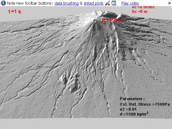
12 TITAN 2D calibration GIS-based classified map: Slope map + Elevation profile Bed-friction map Varying bedfriction angles Charbonnier and Gertisser (2009), Bull. Volc. 71 Short- to medium-runout BAFs: Best-fit parameters TITAN 2D Dimensions of initial pile: Length: 100 m Width: 70 m Max. Thickness: 10 m Orientation angle: -90 Source characteristics: Number of flux sources: 1 Mean flux: 4 kg/m².s Active duration of collapse: 50 sec Flow parameters: Internal friction angle: 30 Basal friction angle: Source conditions: Length: 150 m Width: 150 m Flow parameters: Constant retarding stress: Pa Coeff_u2: 0.01 VolcFlow Number of flux sources: 1 Active duration of collapse: 50 sec Density: 1500 kg.m 3 Initial volume: m 3 Initial volume: m 3 12


13 Short- to medium-runout BAFs: TITAN 2D Short- to medium-runout BAFs: VolcFlow 13
 - 210 275 Max. cent. velocity (m.s -1 ) - 34.3 33.2 Area covered (km²) 0.")

14 Short- to medium-runout BAFs: Results Lobe 5 TITAN 2D VolcFlow Flow duration (sec.) Max. cent. velocity (m.s -1 ) Area covered (km²) Deposited volume (10 6 m 3 ) Runout distance (km) Short- to medium-runout BAFs: Results TITAN 2D VolcFlow Front of Lobe 5 14

15 Long-runout BAFs: Best-fit parameters Dimensions of initial pile: Length: 100 m Width: 70 m TITAN 2D Max. Thickness: 20 m Orientation angle: -90 Source characteristics: Number of flux sources: 5 Mean flux: 4 kg/m².s Active duration of collapse: 300 sec Flow parameters: Internal friction angle: 30 Basal friction angle: Source conditions: Length: 150 m Width: 150 m Number of flux sources: 1 Active duration of collapse: 150 sec Flow parameters: Constant retarding stress: Pa Coeff_u2: 0.01 VolcFlow Density: 1200 kg.m 3 Initial volume: ~ m 3 Initial volume: m 3 Long-runout BAFs: Results 14 June p.m TITAN 2D VolcFlow Flow duration (sec.) - ~1200 ~700 Max. cent. velocity (m.s -1 ) Area covered (km²) Deposited volume (10 6 m 3 ) ~ Runout distance (km)


16 TITAN 2D Long-runout BAFs: Results VolcFlow Long-runout BAFs: TITAN 2D K. Gendol K. Gendol
 Incorporation of a suitable empirical law into the model (varying bed friction angles or constant retarding")
17 BAF Hazard Assessment in the Gendol river TITAN 2D VolcFlow Summary and Outlook Realistic numerical models require: Model calibration using well-constrained field parameters (thickness variations, velocity, deposit distribution, transport and emplacement mechanisms of associated flows) Incorporation of a suitable empirical law into the model (varying bed friction angles or constant retarding stress) A realistic set of input parameters (incl. Digital elevation model) Modelling ouput: Flow depths and velocities Runout distances, Inundation areas and Volumes of different types of BAFs Key parameters that control flow behaviour Basis for estimating the areas and levels of hazards associated with BAFs and for improving disaster mitigation plans at Merapi Our Ultimate Aim... Establish TITAN2D/VolcFlow as predictive tools in future eruption at Merapi 17


18 Acknowledgements Volcanological Survey of Indonesia Geophysical Mass Flow Group, SUNY Buffalo, USA Karim Kelfoun, Clermont-Ferrand, France EPSAM Research Institute at Keele University (UK) 18
Volcanoes. volcanic hazards. Image courtesy of USGS.
 Volcanoes volcanic hazards Volcanic hazards Pyroclastic flows and surges Pyroclastic flows and surges PYROCLAST: all solid fragments ejected from volcanoes PYROCLASTIC FLOW: A flow of hot gas and volcanic
Fieldwork report: Physical volcanology and hazards Volcán de Fuego, Guatemala: January February 2009 Rüdiger Escobar-Wolf
 Summary: Fieldwork report: Physical volcanology and hazards Volcán de Fuego, Guatemala: January February 2009 Rüdiger Escobar-Wolf Fieldwork to gather information on the hazards and risk related to volcanic
Debris Avalanches. Debris avalanche deposits on a volcano in Chile. All of the area in the foreground is buried by a thick debris avalanche.
 Debris Avalanches Volcanoes are not very stable structures. From time to time, they collapse producing large rock and ash avalanches that travel at high speeds down valleys. Collapse maybe caused by an
Volcanic Mass Flow Processes and Deposits
 Volcanic Mass Flow Processes and Deposits Smith and Lowe, 1991 Lahars=hyperconcentrated (flood) flow (HFF) and debris flow Note ideal HFF deposit has normal grading, parallel bedding, better sorting Ideal
Latitude: 42 49'36" N, Longitude: '41" E, Elevation: 1,898 m (Ezo-Fuji) (Elevation Point)
 (Elevation Point)") 16.Yoteizan Latitude: 42 49'36" N, Longitude: 140 48'41" E, Elevation: 1,898 m (Ezo-Fuji) (Elevation Point) Overview of Yoteizan taken from northwest side on May 18, 2003 by the Japan Meteorological Agency
16.Yoteizan Latitude: 42 49'36" N, Longitude: 140 48'41" E, Elevation: 1,898 m (Ezo-Fuji) (Elevation Point) Overview of Yoteizan taken from northwest side on May 18, 2003 by the Japan Meteorological Agency
Interactive comment on Dome instability at Merapi volcano identified by drone photogrammetry and numerical modeling by Herlan Darmawan et al.
 Nat. Hazards Earth Syst. Sci. Discuss., https://doi.org/10.5194/nhess-2018-120-ac3, 2018 Author(s) 2018. This work is distributed under the Creative Commons Attribution 4.0 License. Interactive comment
Geophysical surveys Anomaly maps 2D modeling Discussion Conclusion
 Introduction Geophysical surveys Anomaly maps 2D modeling Discussion Conclusion General context Growth of volcanic domes is a multiphase process: extrusion phases 2005 lava dome growth inside the Mount
Also, when Cascade volcanoes do erupt, high-speed avalanches of pyroclastic flows
 INTRODUCTION A volcano is a vent through which molten rock escapes to the Earth s surface. Unlike other mountains, which are pushed up from below, volcanoes are built by surface accumulation of their eruptive
GEOS 606 Physical Volcanology GEOS 606 CRN credits
 GEOS 606 Physical Volcanology GEOS 606 CRN 74060 3 credits September 1th December 17 th, 2011 Mondays, Wednesdays and Fridays MWF 10:30-11:30 Irving 208 and Elvey 101 Dr. Jonathan Dehn office: WRRB 108G,
Volcanoes. Introduction
 Volcanoes Introduction Display Slide V-0 Explain that a volcano is a vent through which molten rock escapes to the Earth s surface. Unlike other mountains, which are pushed up from below, volcanoes are
Modeling dense pyroclastic basal flows from collapsing columns
 Click Here for Full Article GEOPHYSICAL RESEARCH LETTERS, VOL. 35, L04305, doi:10.1029/2007gl032585, 2008 Modeling dense pyroclastic basal flows from collapsing columns E. E. Doyle, 1 A. J. Hogg, 2 H.
The Application of Sabo Technology for Lahars Flood Mitigation and Warning System in Volcanic Area. Agus Sumaryono Bambang Sukatja F.
 The Application of Sabo Technology for Lahars Flood Mitigation and Warning System in Volcanic Area Agus Sumaryono Bambang Sukatja F. Tata Yunita BACKGROUND The Indonesia Government has constructed several
Volcanic Plumes. JOHN WILEY & SONS Chichester New York Weinheim Brisbane Singapore Toronto
 Volcanic Plumes R. S. J. SPARKS University of Bristol, UK M. I. BURSIK State University of New York, USA S. N. CAREY University of Rhode Island, USA J. S. GILBERT Lancaster University, UK L. S. GLAZE NASA/Goddard
WET EXPLOSIVE ERUPTIONS. Hawaii Photograph: Dorian Weisel
 WET EXPLOSIVE ERUPTIONS Hawaii Photograph: Dorian Weisel WET EXPLOSIVE ERUPTIONS mechanisms hot magma/ hot rock + water pyroclasts + steam rapid expansion of gas fragmentation of magma + wall rock external
Volcanism (Chapter 5)
") GEOLOGY 306 Laboratory Instructor: TERRY J. BOROUGHS NAME: Volcanism (Chapter 5) For this assignment, you will require: a calculator, colored pencils, string, protractor, stereoscopes (provided). Objectives
GEOLOGY 306 Laboratory Instructor: TERRY J. BOROUGHS NAME: Volcanism (Chapter 5) For this assignment, you will require: a calculator, colored pencils, string, protractor, stereoscopes (provided). Objectives
48. Myokosan. Summary. (48. Myokosan) Latitude: 36 53'29" N, Longitude: '49" E, Elevation: 2,454 m (Myokosan) (Elevation Point)
 Latitude: 36 53'29 N, Longitude: '49 E, Elevation: 2,454 m (Myokosan) (Elevation Point)") 48. Myokosan Latitude: 36 53'29" N, Longitude: 138 06'49" E, Elevation: 2,454 m (Myokosan) (Elevation Point) The eastern view of Myokosan taken from on May 7, 2009 by the Japan Meteorological Agency Summary
48. Myokosan Latitude: 36 53'29" N, Longitude: 138 06'49" E, Elevation: 2,454 m (Myokosan) (Elevation Point) The eastern view of Myokosan taken from on May 7, 2009 by the Japan Meteorological Agency Summary
Nevado Del Ruiz, Lahars
 Nevado Del Ruiz, 1985 - Lahars Lecture Objectives -Basics of lahars: definition, characteristics -Ruiz case study: hazards, impacts Mt. Pinatubo lahar footage by Mike Dolan (MTU) Mt. Pinatubo lahar footage
Volcanic Disaster Mitigation for Living in Harmony with Active Volcanoes
 Volcanic Disaster Mitigation for Living in Harmony with Active Volcanoes SURONO Expert Staf of Ministry of Energy and Mineral Resources, Republic of Indonesia Presented on : The 9 th International Graduate
24. Towada. Summary. (24. Towada)
") 24. Towada Latitude: 40 27'34" N, Longitude: 140 54'36" E, Elevation: 690 m (Ogurayama) (Triangulation Point - Ogurayama) Latitude: 40 30'37" N, Longitude: 140 52'48" E, Elevation: 1,011 m (Ohanabeyama)
24. Towada Latitude: 40 27'34" N, Longitude: 140 54'36" E, Elevation: 690 m (Ogurayama) (Triangulation Point - Ogurayama) Latitude: 40 30'37" N, Longitude: 140 52'48" E, Elevation: 1,011 m (Ohanabeyama)
From Punchbowl to Panum: Long Valley Volcanism and the Mono-Inyo Crater Chain
 From Punchbowl to Panum: Leslie Schaffer E105 2002 Final Paper Long Valley Volcanism and the Mono-Inyo Crater Chain Figure 1. After a sequence of earthquakes during the late 1970 s to the early 1980 s
CONCEPT ON SUSTAINABLE SAND MINING MANAGEMENT IN MERAPI AREA
 CONCEPT ON SUSTAINABLE SAND MINING MANAGEMENT IN MERAPI AREA Jazaul IKHSAN 1, Masaharu FUJITA 2, Hiroshi TAKEBAYASHI 3 and Muhammad SULAIMAN 4 1 Member of JSCE, Graduate Student, Dept. of Civil and Earth
19. Esan Continuously Monitored by JMA
 19. Esan Continuously Monitored by JMA Latitude: 41 48'17" N, Longitude: 141 09'58" E, Elevation: 618 m (Esan) (Triangulation Point) Overview of Esan, taken from east side on March 13, 2009 by the Japan
Daniel Frost & Stefan Lachowycz
 Daniel Frost & Stefan Lachowycz Studying the Colima active volcano, Mexico 2009 Daniel and Stefan studied Earth Science at Oxford University. For their project they went to Mexico to work as field assistants
arxiv:cond-mat/ v3 [cond-mat.stat-mech] 30 Jul 2004
![arxiv:cond-mat/ v3 [cond-mat.stat-mech] 30 Jul 2004](/thumbs/77/76691732.jpg "arxiv:cond-mat/ v3 [cond-mat.stat-mech] 30 Jul 2004") Relation between dry granular flow regimes and morphology of deposits: formation of levées in pyroclastic deposits arxiv:cond-mat/5v [cond-mat.stat-mech] Jul Gwenaëlle Félix and Nathalie Thomas Laboratoire
Relation between dry granular flow regimes and morphology of deposits: formation of levées in pyroclastic deposits arxiv:cond-mat/5v [cond-mat.stat-mech] Jul Gwenaëlle Félix and Nathalie Thomas Laboratoire
Pyroclastic Flows. Lesson 6
 Pyroclastic Flows Lesson 6 P yroclastic flows are one of the most dangerous natural events that occur on our planet. They can at hurricane speeds down the slopes of a mountain, destroying everything in
VOLCANIC ERUPTION PRODUCTS AND ITS SLOPE STABILITY IN MERAPI VOLCANO, YOGYAKARTA
 Geotec., Const. Mat. & Env., DOI: https://doi.org/10.21660/2018.51.95296 ISSN: 2186-2982 (Print), 2186-2990 (Online), Japan VOLCANIC ERUPTION PRODUCTS AND ITS SLOPE STABILITY IN MERAPI VOLCANO, YOGYAKARTA
89. Wakamiko. Summary. Latitude: ' N, Longitude: ' E, Depth: -77 m (Central cone) (89. Wakamiko)
 (89. Wakamiko)") 89. Wakamiko Latitude: 31 39.8' N, Longitude: 130 47.9' E, Depth: -77 m (Central cone) Summary Wakamiko is a submarine caldera located in the northeast corner of the Aira caldera, located deep in Kagoshima
89. Wakamiko Latitude: 31 39.8' N, Longitude: 130 47.9' E, Depth: -77 m (Central cone) Summary Wakamiko is a submarine caldera located in the northeast corner of the Aira caldera, located deep in Kagoshima
Orting Community College Proposal
 Orting Community College Proposal Cedric, Celina, Francine, Sarah, Samuel GEO CORP Located in Washington, 42 miles south of Seattle. Situated between two rivers on fertile plains. Built on lahar deposits.
Recent activity. Current episode 12 years Transition between styles 4 periods of dome growth Since 2003, Vulcanian explosions (4 25 per day)
") Recent activity Current episode 12 years Transition between styles 4 periods of dome growth Since 2003, Vulcanian explosions (4 25 per day) 02 December 09 Explosions originating from dome e.g. 10 Jan 2010
Recent activity Current episode 12 years Transition between styles 4 periods of dome growth Since 2003, Vulcanian explosions (4 25 per day) 02 December 09 Explosions originating from dome e.g. 10 Jan 2010
Decoupling of small-volume pyroclastic flows and related hazards at Merapi volcano, Indonesia
 Decoupling of small-volume pyroclastic flows and related hazards at Merapi volcano, Indonesia Jean-Louis Bourdier, E.K. Abdurachman To cite this version: Jean-Louis Bourdier, E.K. Abdurachman. Decoupling
Why was this eruption important?
 Mount St. Helens Mount St. Helens has a long geological history (>3,000 yrs) of explosive eruptions. The 1980 Events: Initial relatively mild steam and ash (Vulcanian) eruptions. Sustained plinian eruption
The status of the Mt. Meager Volcanic Complex. Glyn Williams-Jones Department of Earth Sciences Simon Fraser University
 The status of the Mt. Meager Volcanic Complex Glyn Williams-Jones Department of Earth Sciences Simon Fraser University Location 60 km NW of Pemberton, BC Canadian segment of Cascades Location 60 km NW
New A-Level Physical Geography
 Half Term 1 3.1 Physical Geography: 3.1.5 Hazards: Plate Tectonics This optional section of our specification focuses on the lithosphere and the atmosphere, which intermittently but regularly present natural
Pyroclastic Block Flow from the September, 1976, Eruption of La Soufri~re Volcano, Guadeloupe
 Pyroclastic Block Flow from the September, 1976, Eruption of La Soufri~re Volcano, Guadeloupe M.F. SHERIDAN Department o[ Geology, Arizona State University, Tempe, Arizona 85281, USA ABSTRACT A phreatic
Nick Varley Universidad de Colima, Mexico
 Nick Varley Universidad de Colima, Mexico nick@ucol.mx Remote sensing often is the first signal of a new eruption for remote volcanoes Fumarole direct temperature measurements Spring water temperatures
A New College in Orting?
 A New College in Orting? Risk Report and Recommendation by: Safe Schools Kause Everyone Deserves (SSKED) 2017 Geographic location and physical site of Orting The city of Orting is located in Pierce county,
Volcanology. The study of volcanoes
 Volcanology The study of volcanoes Magma forms wherever temperature and pressure are high enough to melt rock. Some magma forms at the aesthenosphere Magma also forms at plate boundaries, where intense
Deep Water Systems and Sequence Stratigraphy. By: Matt Kyrias, Chris Majerczyk, Nick Whitcomb, Wesley Vermillion
 Deep Water Systems and Sequence Stratigraphy By: Matt Kyrias, Chris Majerczyk, Nick Whitcomb, Wesley Vermillion Contents Gravity Flow Depositional Elements Defined References NOTE: Source uses seismic
Assessing the Volcanic Threat in Latin America. Jose L. Palma, University at Buffalo Bill Rose, Michigan Technological University
 Assessing the Volcanic Threat in Latin America Jose L. Palma, University at Buffalo Bill Rose, Michigan Technological University PASI Workshop, January 2011 Natural Disasters by Type, 1991-2005 90% 7%
Estimates of the Dynamics of Volcano Eruption Column Using Real-time AVHRR Data
 Estimates of the Dynamics of Volcano Eruption Column Using Real-time AVHRR Data Ignacio Galindo Centro Universitario de Investigaciones en Ciencias del Ambiente (CUICA) UNIVERSIDAD DE COLIMA, Colima, México
! Profile of Mauna Loa in Hawaii. Mauna Loa is one of five huge shield volcanoes that make up the island of Hawaii.
 - Shield Volcanoes - Low, rounded profiles; slope angles 2-10 ; composed of numerous flows of mafic composition and little explosive activity - Largest of all volcanoes! Shield volcanoes consist of numerous
Calc-alkaline Volcanic Rocks. Calc-alkali Volcanics. Fabric. Petrography. Compositional Classification. Petrography. Processes.
 Calc-alkaline Volcanic Rocks Calc-alkali Volcanics Winter Chapters 16 & 17 Petrography Processes Field relations Volcanic arcs Petrogenesis Petrography Fabric Classification Alteration Fabric Aphanitic
Data Repository Item 1
 GSA DR 2006031 Burgisser, p. 1 Data Repository Item 1 of Burgisser, A., and Gardner. J., Using Hydraulic Equivalence to Discriminate Transport Processes of Volcanic Flows This Electronic Supplement contains
LEMBAGA PENERBANGAN DAN ANTARIKSA NASIONAL INDONESIAN NATIONAL INSTITUTE OF AERONAUTICS AND SPACE (LAPAN)
") LEMBAGA PENERBANGAN DAN ANTARIKSA NASIONAL INDONESIAN NATIONAL INSTITUTE OF AERONAUTICS AND SPACE (LAPAN) The Utilization of Remotely Sensed Data to Analyze The Estimated Volume of Pyroclastic Deposits
LEMBAGA PENERBANGAN DAN ANTARIKSA NASIONAL INDONESIAN NATIONAL INSTITUTE OF AERONAUTICS AND SPACE (LAPAN) The Utilization of Remotely Sensed Data to Analyze The Estimated Volume of Pyroclastic Deposits
DEBRIS FLOW DISASTER MITIGATION THROUGH COMMUNITY-BASED INTEGRATED SEDIMENT MANAGEMENT (BEST PRACTICE IN MT. MERAPI AREA, INDONESIA)
") Civil Engineering Forum Volume XXI/3 - September 2012 DEBRIS FLOW DISASTER MITIGATION THROUGH COMMUNITY-BASED INTEGRATED SEDIMENT MANAGEMENT (BEST PRACTICE IN MT. MERAPI AREA, INDONESIA) K. Otani Yachiyo
Civil Engineering Forum Volume XXI/3 - September 2012 DEBRIS FLOW DISASTER MITIGATION THROUGH COMMUNITY-BASED INTEGRATED SEDIMENT MANAGEMENT (BEST PRACTICE IN MT. MERAPI AREA, INDONESIA) K. Otani Yachiyo
Large Volcanic Debris Avalanches; Characteristics, Distribution, and Hazards
 Lee Siebert discussion: 25 Jan 2007 Large Volcanic Debris Avalanches; Characteristics, Distribution, and Hazards UBC: 1. What are the differences between cohesive and non cohesive debris flows? (Is it
Quantifying the hazard of catastrophic rock avalanches
 IRASMOS Symposium, Davos, Switzerland, 15-16 May 2008 Quantifying the hazard of catastrophic rock avalanches Acknowledging John J. Clague Ken Hewitt Reginald L. Hermanns Isaac J. Larsen Alexander L. Strom
Pyroclastic Deposits I: Pyroclastic Fall Deposits
 Pyroclastic Deposits I: Pyroclastic Fall Deposits EAS 458 Volcanology Introduction We have seen that physics is useful in understanding volcanic processes, but physical models must be constrained by and
Multiscalar Approach of Merapi Volcanic Erosion - Approche Multi Scalaire d Erosion de Volcan Merapi -
 Multiscalar Approach of Merapi Volcanic Erosion - Approche Multi Scalaire d Erosion de Volcan Merapi - Sandy Budi Wibowo PhD student at Univ. Paris 1 (N étudiant: 10928433) CDD Ingénieur d études (N agent
NRS509 David Kratzmann Nov 30 th 2005
 Application of GIS in Mapping Lava Flows 1.0 Introduction The constant growth of the human population and the migration of these people into hazardous areas has given rise to an apparent increase in natural
Topic 1: Modeling SFU: (JVGR 1992)
") Topic 1: Modeling SFU: (JVGR 1992) 1. Were different chamber top shapes used other than flat, i.e. convex, concave, convoluted / ridged? What is the sensitivity of your models to this? Also, was there
Topic 1: Modeling SFU: (JVGR 1992) 1. Were different chamber top shapes used other than flat, i.e. convex, concave, convoluted / ridged? What is the sensitivity of your models to this? Also, was there
Erupted and killed approximately 15,000 people 200 years ago
 1 2 3 4 5 6 7 8 Introduction to Environmental Geology, 5e Chapter 8 Volcanic Activity Volcanoes: summary in haiku form A volcano forms. Magma comes to the surface - explodes, if felsic. Case History: Mt.
Continuously Monitored by JMA. Latitude: 34 13'10" N, Longitude: '11" E, Elevation: 572 m (Tenjosan) (Triangulation Point - Kozushima)
 (Triangulation Point - Kozushima)") 61. Kozushima Continuously Monitored by JMA Latitude: 34 13'10" N, Longitude: 139 09'11" E, Elevation: 572 m (Tenjosan) (Triangulation Point - Kozushima) Overview of Kozushima taken from south-southeast
61. Kozushima Continuously Monitored by JMA Latitude: 34 13'10" N, Longitude: 139 09'11" E, Elevation: 572 m (Tenjosan) (Triangulation Point - Kozushima) Overview of Kozushima taken from south-southeast
River Response. Sediment Water Wood. Confinement. Bank material. Channel morphology. Valley slope. Riparian vegetation.
 River Response River Response Sediment Water Wood Confinement Valley slope Channel morphology Bank material Flow obstructions Riparian vegetation climate catchment vegetation hydrological regime channel
LECTURE #11: Volcanic Disasters: Lava Properties & Eruption Types
 GEOL 0820 Ramsey Natural Disasters Spring, 2018 LECTURE #11: Volcanic Disasters: Lava Properties & Eruption Types Date: 13 February 2018 I. Exam I grades are posted on the class website (link at the bottom
PLINIAN AND SUBPLINIAN ERUPTIONS
 PLINIAN AND SUBPLINIAN ERUPTIONS A FIELD PERSPECTIVE RAFFAELLO CIONI DIP.TO SCIENZE DELLA TERRA UNIVERSITA DI FIRENZE THANKS TO: MAURO ROSI, MARCO PISTOLESI, COSTANZA BONADONNA, KATHY CASHMAN, LUCIA GURIOLI,
GEOTHERMAL ENERGY POTENTIAL FOR LONGONOT PROSPECT, KENYA. By Mariita N. O. Kenya Electricity Generating Company
 GEOTHERMAL ENERGY POTENTIAL FOR LONGONOT PROSPECT, KENYA By Mariita N. O. Kenya Electricity Generating Company PRESENTATION OUTLINE INTRODUCTION REGIONAL SETTING GEOLOGY GEOTHERMAL MANIFESTATIONS HYDROGEOLOGY
Homework III. Volcanological Exercises
 Page 1 of 5 EENS 3050 Tulane University Natural Disasters Prof. Stephen A. Nelson Homework III. Volcanological Exercises This page last updated on 16-Feb-2018 1. In your work as an insurance company executive
Volcanoes. Environmental Geology, Mr. Paul Lowrey Stacey Singleton, Cassandra Combs, Dwight Stephenson, Matt Smithyman
 Volcanoes Environmental Geology, Mr. Paul Lowrey Stacey Singleton, Cassandra Combs, Dwight Stephenson, Matt Smithyman EMPACTS Project, Spring 2017 Northwest Arkansas Community College, Bentonville, AR
Numerical Simulations of Turbulent Flow in Volcanic Eruption Clouds
 Numerical Simulations of Turbulent Flow in Volcanic Eruption Clouds Project Representative Takehiro Koyaguchi Authors Yujiro Suzuki Takehiro Koyaguchi Earthquake Research Institute, University of Tokyo
Figure 8-21 Distribution of Lava Flow for the Model
 Figure 8-21 Distribution of Lava Flow for the Model 2) Pyroclastic Flow The energy cone model was used for the simulation. a. The angle of inclination of Energy Line, φ, from the summit was 5.3 degrees
Part II: Succession Stations
 Part II: Succession Stations Station 1: Mount St. Helens - Before and After Mount St. Helens is a volcano in the Cascade Mountain range in Washington state. For many years, it was dormant. Then, at 8:32
4.Mashu. Summary. Latitude: 43 34'20" N, Longitude: '39" E, Elevation: 857 m (Kamuinupuri) (Elevation Point) (4. Mashu)
 (Elevation Point) (4. Mashu)") 4.Mashu Latitude: 43 34'20" N, Longitude: 144 33'39" E, Elevation: 857 m (Kamuinupuri) (Elevation Point) Overview of Mashu taken from 3 rd Observation Platform on west side on October 16, 2012 by the Japan
4.Mashu Latitude: 43 34'20" N, Longitude: 144 33'39" E, Elevation: 857 m (Kamuinupuri) (Elevation Point) Overview of Mashu taken from 3 rd Observation Platform on west side on October 16, 2012 by the Japan
Subaerial Felsic Lava Flows and Domes
 Subaerial Felsic Lava Flows and Domes Occurrence Alone or in linear and arcuate chains up to 20 km long Margins of calderas or volcanic depressions. Feeder occupies synvolcanic fault (ring fracture). Extrusion
Get in Touch with Tapasvi IAS
 Barren Island Volcano Erupted Again, Facts About Barren Island Get in Touch with Tapasvi IAS Join us on Facebook for daily updates and important material for UPSC Join Now Join our Telegram Channel and
International Snow Science Workshop Grenoble Chamonix Mont-Blanc
 Towards a basic avalanche characterization based on the generated seismic signal Alec van Herwijnen, Lisa Dreier, Perry Bartelt WSL Institute for Snow and Avalanche Research SLF, Davos, Switzerland ABSTRACT:
Igneous and Metamorphic Rock Forming Minerals. Department of Geology Mr. Victor Tibane SGM 210_2013
 Igneous and Metamorphic Rock Forming Minerals Department of Geology Mr. Victor Tibane 1 SGM 210_2013 Intrusive and Effusive Rocks Effusive rocks: rapid cooling small crystalls or glas Lava & ash Magmatic
SIO15 Midterm 1, Monday Oct. 30, 2017 TEST VARIATION: 2
 SIO15 Midterm 1, Monday Oct. 30, 2017 TEST VARIATION: 2 1) Over the last 20 years, which of these natural disasters killed the most people in the U.S.? a) heat waves b) hurricanes c) lightning strikes
Nuées ardentes of 22 November 1994 at Merapi volcano, Java, Indonesia.
 Nuées ardentes of 22 November 1994 at Merapi volcano, Java, Indonesia. E.K. Abdurachman, Jean-Louis Bourdier, B. Voight To cite this version: E.K. Abdurachman, Jean-Louis Bourdier, B. Voight. Nuées ardentes
Mt St Helens was know to have entered into active periods that lasted from years once every years over the last 500 years, (Figure 5).
.") Lecture #8 notes; Geology 3950, Spring 2006; CR Stern May 1980 eruption of Mt St Helens volcano (text pages 183-192 in the 4 th edition and 206-222 in the 5 th edition) Mt St Helens in southwest Washington
Lecture #8 notes; Geology 3950, Spring 2006; CR Stern May 1980 eruption of Mt St Helens volcano (text pages 183-192 in the 4 th edition and 206-222 in the 5 th edition) Mt St Helens in southwest Washington
Part A GEOLOGY 12 CHAPTER 4 WORKSHEET VOLCANOES. Name
 GEOLOGY 12 CHAPTER 4 WORKSHEET VOLCANOES Name Part A 1. The rough, jumbled blocky or jagged surface of a lava flow is called a. pahoehoe b. lahar c. aa d. phreatic 2. The Cascade volcanoes like Mt. St.
GLG Ch 6: Volcanoes & Volcanic Hazards. 3. Name, describe (DSC) and draw the three types of volcanoes from smallest to largest.
 and draw the three types of volcanoes from smallest to largest.") GLG 101 - Ch 6: Volcanoes & Volcanic Hazards Name 6.1 What Is and and Is Not a Volcano? 1. Three common characteristics of a volcano include A B C 2. How did the Hopi Buttes (figure 06 01.b1) form? 3.
GLG 101 - Ch 6: Volcanoes & Volcanic Hazards Name 6.1 What Is and and Is Not a Volcano? 1. Three common characteristics of a volcano include A B C 2. How did the Hopi Buttes (figure 06 01.b1) form? 3.
Progress Report: Sentinel Asia Success Story in the Philippines
 Progress Report: Sentinel Asia Success Story in the Philippines 3 rd Joint Project Team Meeting on the Sentinel Asia STEP-2 July 6-8, 2010 Hyatt Hotel, Manila, Philippines Renato U. Solidum Jr. Director
AND. A GEOMORPHOLOGIST SVIEWS HERMAN Th. VERSTAPPEN. International Institute for Geoinformation. Enschede the Netherlands
 NATURAL DISASTER REDUCTION AND ENVIRONMENTAL MANAGEMENT A GEOMORPHOLOGIST SVIEWS HERMAN Th. VERSTAPPEN Em. Professor of Geomorphology International Institute for Geoinformation Science and Earth Observation
GEOL1 Physical Geology Laboratory Manual College of the Redwoods Lesson Five: Volcanoes Background Reading: Volcanoes Volcanic Terms: Silca:
 Name: Date: GEOL1 Physical Geology Laboratory Manual College of the Redwoods Lesson Five: Volcanoes Background Reading: Volcanoes Volcanic Terms: Silca: SiO 2 silicon dioxide. This is quartz when it crystallizes.
Foundations of Earth Science, 6e Lutgens, Tarbuck, & Tasa
 Foundations of Earth Science, 6e Lutgens, Tarbuck, & Tasa Fires Within: Igneous Activity Foundations, 6e - Chapter 7 Stan Hatfield Southwestern Illinois College The nature of volcanic eruptions Characteristics
Visualizing Earth Science. Chapter Overview. Volcanoes and Eruption Types. By Z. Merali and B. F. Skinner. Chapter 9 Volcanism and Other
 Visualizing Earth Science By Z. Merali and B. F. Skinner Chapter 9 Volcanism and Other Igneous Processes Volcanoes types and effects of eruption Chapter Overview Melting and cooling of rocks Geological
Guidance for GEOGRAPHY End of Year Examination 2016
 Guidance for GEOGRAPHY End of Year Examination 2016 The End of Year Examination takes place in Week 4 of the Summer Term. The Geography Examination will last 50 minutes. The Examination will include questions
Multiple Choice Identify the letter of the choice that best completes the statement or answers the question.
 volcano sample test Multiple Choice Identify the letter of the choice that best completes the statement or answers the question. 1. Volcanic belts form along a. islands in the Pacific Ocean. b. North American
Scarpati Claudio and Perrotta Annamaria
 GSA DATA REPOSITORY 2012292 Supplemental Information Scarpati Claudio (email:claudio.scarpati@unina.it) and Perrotta Annamaria Dipartimento di Scienze della Terra, Università di Napoli Federico II Erosional
GLY July Ms. Nelda Breedt. Plates move slowly and eventually.
 GLY 162 Tectonic Processes: Volcanism Ms. Nelda Breedt GLY 162 Environmental Geology Plate Tectonics Plates move slowly and eventually. 2 Spread apart (divergent plates) Dive beneath one another (converging
Latitude: 43 25'03" N, Longitude: '52" E, Elevation: 1,692 m (Maruyama) (Triangulation Point)
 (Triangulation Point)") 8.Maruyama Latitude: 43 25'03" N, Longitude: 143 01'52" E, Elevation: 1,692 m (Maruyama) (Triangulation Point) Overview of Maruyama taken from northwest side on July 2, 2007 by the Japan Meteorological
8.Maruyama Latitude: 43 25'03" N, Longitude: 143 01'52" E, Elevation: 1,692 m (Maruyama) (Triangulation Point) Overview of Maruyama taken from northwest side on July 2, 2007 by the Japan Meteorological
32. Hijiori. Summary. (32. Hijiori) Latitude: 38 35'57" N, Longitude: '42" E, Elevation: 552 m (Sankakuyama) (Elevation Point - measured by JMA)
 Latitude: 38 35'57 N, Longitude: '42 E, Elevation: 552 m (Sankakuyama) (Elevation Point - measured by JMA)") (32. Hijiori) 32. Hijiori Latitude: 38 35'57" N, Longitude: 140 09'42" E, Elevation: 552 m (Sankakuyama) (Elevation Point - measured by JMA) Overview of Hijiori - Aerial Photo Taken from East Side - Courtesy
(32. Hijiori) 32. Hijiori Latitude: 38 35'57" N, Longitude: 140 09'42" E, Elevation: 552 m (Sankakuyama) (Elevation Point - measured by JMA) Overview of Hijiori - Aerial Photo Taken from East Side - Courtesy
Debris flow: categories, characteristics, hazard assessment, mitigation measures. Hariklia D. SKILODIMOU, George D. BATHRELLOS
 Debris flow: categories, characteristics, hazard assessment, mitigation measures Hariklia D. SKILODIMOU, George D. BATHRELLOS Natural hazards: physical phenomena, active in geological time capable of producing
Pyroclastic flows are volcanic phenomena. A pyroclastic flow is a high-density mixture of hot, fragmented solids and expanding gases.
 This website would like to remind you: Your browser (Apple Safari 4) is out of date. Update your browser for more security, comfort and the best experience on this site. Encyclopedic Entry flow block-and-ash
GSA DATA REPOSITORY Esposti Ongaro et al. Supplement A. Multiphase flow formulation
 GSA DATA REPOSITORY 2011173 Esposti Ongaro et al. Supplement A. Multiphase flow formulation Model equations Model equations express the Eulerian balance of mass, momentum and enthalpy for one gas phase,
Year 8 Practice Questions for Summative Assessment. NAME:...
 Year 8 Practice Questions for Summative Assessment. NAME:... Earthquakes and Volcanoes 1. (a) The diagram below shows a simple cross section of the Earth. Complete the labels. (b) Name an earthquake you
A bowl shaped depression formed by the collapse of a volcano is called a. Magma that has left the vent of a volcano is known as. Lava.
 Magma that has left the vent of a volcano is known as Lava A bowl shaped depression formed by the collapse of a volcano is called a Caldera This can form in a caldera when magma starts to come back up
Clough Award 2017 Katmai and the Valley of Ten Thousand Smokes
 Clough Award 2017 Katmai and the Valley of Ten Thousand Smokes In June 2017, Clough Award funding allowed me to participate in the International Volcanology Summer School, organised by University of Alaska
The Bishop Tuff : An Overview of the World s Roughest and Toughest Volcanic Landform
 The Bishop Tuff : An Overview of the World s Roughest and Toughest Volcanic Landform Charity J. Southworth Indiana University, 2012 Abstract The Bishop Tuff is a welded tuff that was created 760,000 years
Current and potential use of high resolution imagery in volcanology
 Current and potential use of high resolution imagery in volcanology Marcello de Michele, Bureau de Recherches Géologiques et Minières (BRGM), Orleans, France With the contribution of: Jean Christophe Komorowski,
GEOLOGY MEDIA SUITE Chapter 12
 UNDERSTANDING EARTH, SIXTH EDITION GROTZINGER JORDAN GEOLOGY MEDIA SUITE Chapter 12 Volcanoes 2010 W.H. Freeman and Company Plate tectonics explains the global pattern of volcanism. Key Figure 12.20 (page
Volcanoes. 11/25/2013. Geology 15 Lecture 27 VOLCANO!
 Hazard Update Surprise POP Review Tsunami Activity 10 B Today s Material Volcanoes Volcanic Hazards Geology 15 Lecture 27 VOLCANO! http://motherboard.vice.com/blog/watch an erupting volcano create a newisland
WHEN IS A SURGE NOT A SURGE? THAT IS THE PERPLEXING QUESTION. (for emergency managers)
") WHEN IS A SURGE NOT A SURGE? THAT IS THE PERPLEXING QUESTION (for emergency managers) Mount St Helens, May 18, 1980 37 years, 5 months, and 6 days ago.. Eyewitnesses there were many! Rosenbaum and Waitt,
WHEN IS A SURGE NOT A SURGE? THAT IS THE PERPLEXING QUESTION (for emergency managers) Mount St Helens, May 18, 1980 37 years, 5 months, and 6 days ago.. Eyewitnesses there were many! Rosenbaum and Waitt,
Hawaiian Submarine Volcanism. Stages of Hawaiian Volcanoes:
 Hawaiian Submarine Volcanism November 1, 2011 Mary Tardona GG 711 Stages of Hawaiian Volcanoes: Typically, three main stages: Pre shield Shield Post shield Sometimes followed by: Rejuvenation Stage GG
Volcano Surveillance Using Shortwave Infrared Thermal Data from the ERS Along Track Scanning Radiometers
 Volcano Surveillance Using Shortwave Infrared Thermal Data from the ERS Along Track Scanning Radiometers M. J. Wooster Department of Geography, King s College London, Strand, London, WC2R 2LS, UK. D.A.
EAS 116 Earthquakes and Volcanoes
 EAS 116 Earthquakes and Volcanoes J. Haase Forecasting Volcanic Eruptions Assessment of Volcanic Hazard Is that volcano active? Mount Lassen: 12000 BP and 1915 Santorini, IT: 180,000 BP, 70,000 BP, 21000
3/24/2016. Geology 12 Mr. M. Gauthier 24 March 2016
 Geology 12 Mr. M. Gauthier 24 March 2016 Introduction: Mt. St. Helens Before 1980 Mt. St Helens, in Southern Washington State, had not erupted since 1857 On March 27,1980 minor ashand eruptions were due
Beyond the Book. FOCUS Book
 FOCUS Book Suppose your city wants to build a new housing development on a steep slope outside town. Design a model to test whether the land is safe from the types of landslides you read about in this
FINAL EXAM December 20 th, here at 1:00 3:00 pm
 FINAL EXAM December 20 th, here at 1:00 3:00 pm REVIEW SESSION December 11 th at 6:00-7:30 pm Morrill I Auditorium (Room N375) Same as last time Don t forget your online course evaluations! Major Volcanic