DEBRIS FLOW MONITORING AND WARNING SYSTEMS: A NEW STUDY SITE IN THE ALPS
|
|
|
- Kellie Doyle
- 5 years ago
- Views:
Transcription


1 DEBRIS FLOW MONITORING AND WARNING SYSTEMS: A NEW STUDY SITE IN THE ALPS Comiti F 1, Macconi P 2, Marchi L 3, Arattano M 4, Borga M 5, Brardinoni F 6, Cavalli M 3, D Agostino V 5, Hellweger S 3, Trevisani S 3, Vischi M 7 1 Faculty of Science and Technology, Free University of Bolzano, Italy 2 Dept. Hydraulic Engineering, Autonomous Province of Bolzano, Italy 3 CNR-IRPI, Padova, Italy 4 CNR-IRPI, Torino, Italy 5 Dept. Land and Agroforest Environments, University of Padova, Italy 6 Dept. Geological Sciences and Geotechnologies, Università of Milano-Bicocca, Italy 7 Dept. Civil Protection, Autonomous Province of Bolzano, Italy
2 Flash flooding in steep mountain catchments may result in the development and propagation of hyperconcentrated and debris flows These phenomena represent the most relevant natural hazards in mountain regions. In Europe, these flows cause extensive damages and casualties every year 2


3 3
4 Definition Rapid gravity-driven mass flows of water and sediment, with large solid concentrations such that their rheology is nonnewtonian (i.e. non linear stress-strain relationship) (Debris flood) Caution! Boundaries between types differ among authors! 4
5 Coussout & Meunier (1996) 5

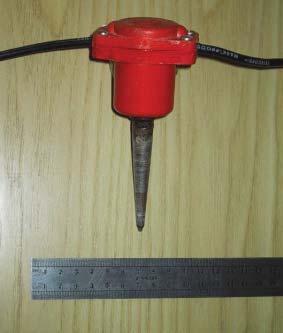
6 Monitoring stations An invaluable contribution for the understanding of such processes Moscardo Torrent Eastern Italian Alps 6
7 How to cope with debris flow risk? Structural measures Reduce hazard Non-structural measures Reduce vulnerability Their combination is in most cases needed 7


8 Structural measures Check-dams, retention basins, dikes, and artificial channels to stop, divert or flush debris flows Effective in most cases, but may present management problems (maintanance costs) 8
9 Non-structural measures Reduce permanently (land use planning) or temporarily (warning systems) the probability that humans and their belongings might be hit by debris flows Permanent solutions are ideal, but socio-economic conflicts! Two types of warning systems: Advance (early) warning systems predict the possible occurrence of a debris flow event by monitoring the possible onset of triggering conditions (rainfall threshold). Longer lead time, but low reliability Event (alert) warning systems detect a debris flow when it already started its propagation. Reliable, but shorter time (few minutes)! 9
10 Sketch of event warning system Rainfall thresholds curves 10


11 The best example in the Alps: The Illgraben torrent in Switzerland 11


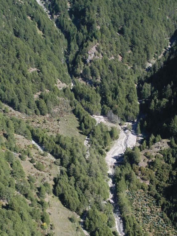
12 A new study site for monitoring and testing warning systems in the Italian Alps Basin area: 6 km 2 Gadria Min elevation: 1,400 m a.s.l. Strimm Max elevation: 2,930 m a.s.l. Average annual precipitation: 500 mm Lasa 12


13 Diffuse dissection In the upper part Consolidation check-dams along the channel Retention basin & open check-dam 13


14 ..but the open check-dam is not actually open! Each year the Province of Bolzano spends 200,000 for sediment removal and disposal 14
15 Objectives of the project Determine deposition patterns in the retention basin, in order to design improved filters of the check-dam Assess debris flow triggering and propagation dynamics (i.e. triggering conditions, flow velocity) Tests protocols of warning systems (to be applied in other basins), including the alert and evacuation stage (civil protection management) 15


16 16

17 Rain gauges In the upper basin 17


18 Server 18
19 Main technical issues of the project The main technical problem in similar basins is the communication of remote instruments (not cable transmission possible) GSM-GPRS may work well, but in certain areas (as in the Gadria) there is no coverage Radio transmission is then needed, but it suffers from certain limitations: range, power supply, costs Continuous instruments self-checks and redundancy is fundamental to guarantee reliable warning. Who is eventually responsible to issue the evacuation alert? When? We will test different protocols with Local Fire dept. and Civil protection 19

20 Conclusions We still know little about debris flow processes! We need to invest in long-term monitoring programme Combined use of structural and non-structural measures is often required. But need to achieve a positive cost-benefit balance. It is vital to map debris flow hazards also in presently unpopulated areas, because once urbanization starts, mitigation costs soar!! 20
Haydar Hussin (1), Roxana Ciurean (2), Paola Reichenbach (1), Cees van Westen (3), Gianluca Marcato (4), Simone Frigerio (4), V. Juliette Cortes (4)
, Roxana Ciurean (2), Paola Reichenbach (1), Cees van Westen (3), Gianluca Marcato (4), Simone Frigerio (4), V. Juliette Cortes (4)") 7/10/2013 Changing Hydro-meteorological Risks - as Analyzed by a New Generation of European Scientists Probabilistic 2D numerical landslide modeling: a first step towards assessing changes in risk due
7/10/2013 Changing Hydro-meteorological Risks - as Analyzed by a New Generation of European Scientists Probabilistic 2D numerical landslide modeling: a first step towards assessing changes in risk due
The SedAlp Project: WP6: INTERACTION WITH STRUCTURES
 The SedAlp Project: WP6: INTERACTION WITH STRUCTURES 6 th International conference Water in the Alps Herrenchiemsee, 12 th of October, 2016 Jošt Sodnik Contents Structure of SedAlp project (www.sedalp.eu)
Regional Flash Flood Guidance and Early Warning System
 WMO Training for Trainers Workshop on Integrated approach to flash flood and flood risk management 24-28 October 2010 Kathmandu, Nepal Regional Flash Flood Guidance and Early Warning System Dr. W. E. Grabs
FLORA: FLood estimation and forecast in complex Orographic areas for Risk mitigation in the Alpine space
 Natural Risk Management in a changing climate: Experiences in Adaptation Strategies from some European Projekts Milano - December 14 th, 2011 FLORA: FLood estimation and forecast in complex Orographic
EIT-Japan Symposium 2011 on Human Security Engineering
 EIT-Japan Symposium 2011 on Human Security Engineering 2011 Disastrous Landslides at Khao Panom, Krabi, Thailand Suttisak Soralump Geotechnical Engineering Research and Development Center (GERD) Faculty
Floods Lecture #21 20
 Floods 20 Lecture #21 What Is a Flood? Def: high discharge event along a river! Due to heavy rain or snow-melt During a flood, a river:! Erodes channel o Deeper & wider! Overflows channel o Deposits sediment
1. INTRODUCTION. EXAMPLE OF SECHILIENNE ROCKFALL (France)
") FORM OSE POST-GRADUATE COURSE Landslide vulnerability and risk 1 FORM OSE POST-GRADUATE COURSE Landslide vulnerability and risk 2 FORM OSE POST-GRADUATE COURSE Landslide vulnerability and risk 3 Christophe
FORM OSE POST-GRADUATE COURSE Landslide vulnerability and risk 1 FORM OSE POST-GRADUATE COURSE Landslide vulnerability and risk 2 FORM OSE POST-GRADUATE COURSE Landslide vulnerability and risk 3 Christophe
Long-term monitoring of bedload and debris flows in two small catchments of the Eastern Italian Alps
 Monitoring, Simulation, Prevention and Remediation of Dense and Debris Flows 147 Long-term monitoring of bedload and debris flows in two small catchments of the Eastern Italian Alps L. Mao 1, M. Cavalli
GENERAL. CHAPTER 1 BACKGROUND AND PURPOSE OF THE GUIDELINES Background of the Guidelines Purpose of the Guidelines...
 GENERAL CHAPTER 1 BACKGROUND AND PURPOSE OF THE GUIDELINES... 1 1.1 Background of the Guidelines... 1 1.2 Purpose of the Guidelines... 3 CHAPTER 2 APPLICATION OF THE GUIDELINES... 3 2.1 Potential Users
Multi-step hazard assessment of debris flows in an Alpine region
 Multi-step hazard assessment of debris flows in an Alpine region R. Genevois Department of Geosciences, University of Padova, Padova, Italy P.R. Tecca CNR-IRPI, Padova, Italy M. Floris, C. Squarzoni &
Landslide Disaster Management in Sri Lanka and Nichola Oya as a Case study. Group 16 Gamini Jayathissa Udeni Nawagamuwa
 Landslide Disaster Management in Sri Lanka and Nichola Oya as a Case study Group 16 Gamini Jayathissa Udeni Nawagamuwa Taiwan Sri lanka >2582 mm, max >5000mm NE= Nov. to Feb 1750 2500 mm >2500 mm Central
Climate change and natural disasters, Athens, Greece October 31, 2018
 Flood early warning systems: operational approaches and challenges Climate change and natural disasters, Athens, Greece October 31, 2018 Athens, October 31, 2018 Marco Borga University of Padova, Italy
The HYDRATE network of hydrometeorological observatories:
 The HYDRATE network of hydrometeorological observatories:. taking stock, looking ahead Marco Borga University of Padova Department of Land and Agroforest Environments marco.borga@unipd.it Outline HYDRATE-NHO:
APPROACH TO THE SPANISH WATER ORGANISATION IMPROVING FLOOD HAZARD MAPPING, LAWS AND AUTHORITIES COORDINATION
 "Workshop On Land Use Planning And Water Management, With Focus On Flood Risk Management Oslo, Norway. Wednesday 31 January and Thursday 1 February 2007 APPROACH TO THE SPANISH WATER ORGANISATION IMPROVING
Measures Also Significant Factors of Flood Disaster Reduction
 Non-Structual Measures Also Significant Factors of Flood Disaster Reduction Babiaková Gabriela, Leškov ková Danica Slovak Hydrometeorological Institute, Bratislava Hydrological Forecasts and Warning Department
URBAS Prediction and management of flash floods in urban areas
 URBAS Prediction and management of flash floods in urban areas 1 Thomas Einfalt, Klaus Friedeheim, Andreas Wagner Project funded by the Federal Ministry of Education and Research BMBF (Germany) as a part
Interpretive Map Series 24
 Oregon Department of Geology and Mineral Industries Interpretive Map Series 24 Geologic Hazards, and Hazard Maps, and Future Damage Estimates for Six Counties in the Mid/Southern Willamette Valley Including
A Roundup of Recent Debris Flow Events in Taiwan
 2015 International Workshop on Typhoon and Flood APEC Experience Sharing on Hazardous Weather Events and Risk Management A Roundup of Recent Debris Flow Events in Taiwan Hsiao-Yuan(Samuel) Yin Ph.D. sammya@mail.swcb.gov.tw
EFFECT OF SAND MINING ACTIVITY ON THE SEDIMENT CONTROL SYSTEM (A CASE STUDY OF SOMBE-LEWARA RIVER, DONGGALA, INDONESIA)
") Civil Engineering Forum Volume XXI/1 - January 01 EFFECT OF SAND MINING ACTIVITY ON THE SEDIMENT CONTROL SYSTEM (A CASE STUDY OF SOMBE-LEWARA RIVER, DONGGALA, INDONESIA) Y. A. Bawias Agency of Public Works,
Civil Engineering Forum Volume XXI/1 - January 01 EFFECT OF SAND MINING ACTIVITY ON THE SEDIMENT CONTROL SYSTEM (A CASE STUDY OF SOMBE-LEWARA RIVER, DONGGALA, INDONESIA) Y. A. Bawias Agency of Public Works,
Science of Natural Disasters: RIVERS& FLOODS! 27 April 2016
 Science of Natural Disasters: RIVERS& FLOODS! 27 April 2016 Rebecca Clotts Department of Geology, University of St Thomas Flood in St Paul, 2014, Star Tribune 1 2 What is a watershed? 3 4 5 6 7 What is
CLIMATE RESILIENT ALTITUDINAL GRADIENTS (CRAGs)
") CLIMATE RESILIENT ALTITUDINAL GRADIENTS (CRAGs) BUILDING CLIMATE CHANGE RESILIENCE IN THE KIVU- RUSIZI WATERSHEDS Great Lake Conference Entebbe 2017 Chris Magero WHAT ARE CRAGs? Climate-Resilient Altitudinal
CLIMATE RESILIENT ALTITUDINAL GRADIENTS (CRAGs) BUILDING CLIMATE CHANGE RESILIENCE IN THE KIVU- RUSIZI WATERSHEDS Great Lake Conference Entebbe 2017 Chris Magero WHAT ARE CRAGs? Climate-Resilient Altitudinal
EFFECT OF TWO SUCCESIVE CHECK DAMS ON DEBRIS FLOW DEPOSITION
 DOI: 10.4408/IJEGE.2011-03.B-116 EFFECT OF TWO SUCCESIVE CHECK DAMS ON DEBRIS FLOW DEPOSITION Farouk Maricar (*), Haruyuki Hashimoto (*), Shinya Ikematsu (*) & Tomohiro Miyoshi (*) (*) Department of Civil
Natural Terrain Risk Management in Hong Kong
 Natural Terrain Risk Management in Hong Kong Nick Koor Senior Lecturer in Engineering Geology School of Earth and Environmental Sciences Slope failures in Hong Kong Man-made Slope Failure - 300 landslides
Use of Climate information in Disaster Risk Management in Zimbabwe
 Use of Climate information in Disaster Risk Management in Zimbabwe WMO Regional Technical Meeting & User/CONOPS Workshop, 28 th October 2015 Lameck Betera Department of Civil Protection Institutional Arrangements
Emerging Needs, Challenges and Response Strategy
 Emerging Needs, Challenges and Response Strategy Development of Integrated Observing Systems in China JIAO Meiyan Deputy Administrator China Meteorological Administration September 2011 Geneva Outline
Hazard Resilience Index (HRI) Earthquakes, Tsunamis, and Volcanoes
 Earthquakes, Tsunamis, and Volcanoes") Hazard Index (HRI) Earthquakes, Tsunamis, and Volcanoes Earthquakes Tsunamis Volcano-Ash Falls, Projectiles and Lateral Blasts, Pyroclastic Flows and Lava Flows Earthquakes, Tsunamis and Volcanoes Please
Hazard Index (HRI) Earthquakes, Tsunamis, and Volcanoes Earthquakes Tsunamis Volcano-Ash Falls, Projectiles and Lateral Blasts, Pyroclastic Flows and Lava Flows Earthquakes, Tsunamis and Volcanoes Please
GUIDELINES FOR CONSTRUCTION TECHNOLOGY TRANSFER DEVELOPMENT OF WARNING AND EVACUATION SYSTEM AGAINST SEDIMENT DISASTERS IN DEVELOPING COUNTRIES
 GUIDELINES FOR CONSTRUCTION TECHNOLOGY TRANSFER DEVELOPMENT OF WARNING AND EVACUATION SYSTEM AGAINST SEDIMENT DISASTERS IN DEVELOPING COUNTRIES MARCH 2004 Ministry of Land, Infrastructure and Transport
LAYMAN S REPORT Floods and Fire Risk Assessment and Management
 LAYMAN S REPORT Floods and Fire Risk Assessment and Management FLIRE is 50% co-financed by LIFE + financial instrument of the European Union. Floods and Fire risk assessment and management Project s code
Understanding disaster risk ~ Lessons from 2009 Typhoon Morakot, Southern Taiwan
 Understanding disaster risk ~ Lessons from 2009 Typhoon Morakot, Southern Taiwan Wen Chi Lai, Chjeng-Lun Shieh Disaster Prevention Research Center, National Cheng-Kung University 1. Introduction 08/10
Experiences of rapid landslides monitoring and warning at catchment scale in the Pyrenees. The example of the Rebaixader test site.
 ID: 0045 Experiences of rapid landslides monitoring and warning at catchment scale in the Pyrenees. The example of the Rebaixader test site. J. Moya 1, M. Hürlimann 1, C. Abancó 1 and I. Vilajosana 2 1
Contribution to the Mountain-Risks project of the Rock Mechanics Laboratory of the Swiss Federal Institute of Technology of Lausanne
 Contribution to the Mountain-Risks project of the Rock Mechanics Laboratory of the Swiss Federal Institute of Technology of Lausanne PhD Student: Jacopo Abbruzzese Supervisor: Dr. Vincent Labiouse MOUNTAIN
National Public Weather and Warning Services in the Swaziland Meteorological Service Dennis S.Mkhonta /
 National Public Weather and Warning Services in the Swaziland Meteorological Service Dennis S.Mkhonta dennis.mkhonta@gmail.com / dennis@swazimet.gov.sz Introduction Swaziland s geographical position exposes
Some considerations on the application of the FLO-2D model for debris flow hazard assessment
 Monitoring, Simulation, Prevention and Remediation of Dense and Debris Flows 159 Some considerations on the application of the FLO-2D model for debris flow hazard assessment V. D Agostino 1 & P. R. Tecca
3/3/2013. The hydro cycle water returns from the sea. All "toilet to tap." Introduction to Environmental Geology, 5e
 Introduction to Environmental Geology, 5e Running Water: summary in haiku form Edward A. Keller Chapter 9 Rivers and Flooding Lecture Presentation prepared by X. Mara Chen, Salisbury University The hydro
ENGINEERING HYDROLOGY
 ENGINEERING HYDROLOGY Prof. Rajesh Bhagat Asst. Professor Civil Engineering Department Yeshwantrao Chavan College Of Engineering Nagpur B. E. (Civil Engg.) M. Tech. (Enviro. Engg.) GCOE, Amravati VNIT,
The Application of Sabo Technology for Lahars Flood Mitigation and Warning System in Volcanic Area. Agus Sumaryono Bambang Sukatja F.
 The Application of Sabo Technology for Lahars Flood Mitigation and Warning System in Volcanic Area Agus Sumaryono Bambang Sukatja F. Tata Yunita BACKGROUND The Indonesia Government has constructed several
New results from sediment transport measurements in two Alpine torrents
 Hydrology, Water Resources and Ecology in Headwaters (Proceedings of the HeadWater'98 Conference held at Meran/Merano, Italy, April 1998). IAHS Publ. no. 248, 1998. 283 New results from sediment transport
WP 5 Sediment Transport Monitoring. WPL: Helmut Habersack - BOKU, PP11
 WP 5 Sediment Transport Monitoring WPL: Helmut Habersack - BOKU, PP11 WP5 - Content 1. Background 2. Aims and actions 3. Monitoring Methods 4. Study Sites 5. Results and Output 6. Main Achievements/Key
COMMUNITY EMERGENCY RESPONSE TEAM FLOODS INTRODUCTION
 INTRODUCTION Floods are one of the most common hazards in the United States. A flood occurs any time a body of water rises to cover what is usually dry land. Flood effects can be local, impacting a neighborhood
International Symposium on Natural Disaster Mitigation. Local vulnerability assessment of landslides and debris flows
 International Symposium on Natural Disaster Mitigation of landslides and debris flows Lessons learnt from Cam Pha town and Van Don district, Quang Ninh province, Vietnam Nguyen Quoc Phi Faculty of Environment
Modeling Great Britain s Flood Defenses. Flood Defense in Great Britain. By Dr. Yizhong Qu
 Modeling Great Britain s Flood Defenses AIRCurrents Editor s note: AIR launched its Inland Flood Model for Great Britain in December 2008. The hazard module captures the physical processes of rainfall-runoff
Investigation of the 2013 Hadari Debris Flow in Korea Through Field Survey and Numerical Analysis
 Investigation of the 2013 Hadari Debris Flow in Korea Through Field Survey and Numerical Analysis Junghae Choi * Department of Earth Science Education, Kyungpook National University, Korea, Assistant Professor
12/07/2017. Flash Flood Warning Service, an advanced approach towards flood resilient cities Floodplain Management Association Conference, Newcastle
 12/07/2017 Worldwide problem: Flash Floods Flash Floods are a Global Problem Flash Flood Warning Service, an advanced approach towards flood resilient cities Floodplain Management Association Conference,
Debris flow hazard and mitigation works in Fiames slope (Dolomites, Italy)
") Monitoring, Simulation, Prevention and Remediation of Dense and Debris Flows 15 Debris flow hazard and mitigation works in Fiames slope (Dolomites, Italy) 1 2 2 P. R. Tecca, C. Armento & R. Genevois 1
Monitoring, Simulation, Prevention and Remediation of Dense and Debris Flows 15 Debris flow hazard and mitigation works in Fiames slope (Dolomites, Italy) 1 2 2 P. R. Tecca, C. Armento & R. Genevois 1
A STUDY ON DEBRIS FLOW DEPOSITION BY THE ARRANGEMENT OF SABO DAM
 Annual Journal of Hydraulic Engineering, JSCE, Vol.57, 2013, February A STUDY ON DEBRIS FLOW DEPOSITION BY THE ARRANGEMENT OF SABO DAM Namgyun Kim 1, Hajime NAKAGAWA 2, Kenji KAWAIKE 3, and Hao ZHANG 4
The 2005 Flood and Sediment Disaster in the Western Parts of Tyrol/Austria Facts und Conclusions
 Disaster Mitigation of Debris Flows, Slope Failures and Landslides 779 The 2005 Flood and Sediment Disaster in the Western Parts of Tyrol/Austria Facts und Conclusions Joerg Heumader Federal Service for
Luca Palmieri Thom Bogaard Miguel Gonzalez-Herraez Alessandro Pasuto. Water JPI WaterWorks2014 Cofunded Call 18 May 2016, Rome
 Luca Palmieri Thom Bogaard Miguel Gonzalez-Herraez Alessandro Pasuto Water JPI WaterWorks2014 Cofunded Call 18 May 2016, Rome Consortium Description ACRONYM TOPIC Coordination Partners DOMINO 3 DIKES AND
Floods. Floods COMMUNITY EMERGENCY RESPONSE TEAM FLOODS CONTENT INSTRUCTOR GUIDANCE
 Floods Floods Introduce this topic by explaining that floods are one of the most common hazards in the United States. A flood occurs any time a body of water rises to cover what is usually dry land. Display
Volume estimation and assessment of debris flow hazard in Mt Umyeon, Seoul
 Volume estimation and assessment of debris flow hazard in Mt Umyeon, Seoul *Ananta Man Singh Pradhan 1) Hyo-Sub Kang 1) Barsha Pradhan 1) Yun-Tae Kim 2) and 1), 2) Department of Ocean Engineering, Pukyong
Landslides & Debris Flows
 T.#Perron# #12.001# #Landslides#&#Debris#Flows# 1# Landslides & Debris Flows Many geologic processes, including those shaping the land surface, are slowacting, involving feedbacks that operate over many
Innovative Ways to Monitor Land Displacement
 ARTICLE Innovative Ways to Monitor Land Displacement When people think about landslides, they usually imagine large mud streams which cause considerable loss of life. Whereas such large-scale disasters
Debris flow: categories, characteristics, hazard assessment, mitigation measures. Hariklia D. SKILODIMOU, George D. BATHRELLOS
 Debris flow: categories, characteristics, hazard assessment, mitigation measures Hariklia D. SKILODIMOU, George D. BATHRELLOS Natural hazards: physical phenomena, active in geological time capable of producing
Smart use of Geographic Information System (GIS) platform for delivering weather information and nowcasting services
 platform for delivering weather information and nowcasting services") Smart use of Geographic Information System (GIS) platform for delivering weather information and nowcasting services C. K. Pan Hong Kong Observatory Hong Kong, China It is a world of beauty Source: Image
Smart use of Geographic Information System (GIS) platform for delivering weather information and nowcasting services C. K. Pan Hong Kong Observatory Hong Kong, China It is a world of beauty Source: Image
Flash Flood Guidance System On-going Enhancements
 Flash Flood Guidance System On-going Enhancements Hydrologic Research Center, USA Technical Developer SAOFFG Steering Committee Meeting 1 10-12 July 2017 Jakarta, INDONESIA Theresa M. Modrick Hansen, PhD
TRANSBOUNDARY FLOOD FORECASTING THROUGH DOWNSCALING OF GLOBAL WEATHER FORECASTING AND RRI MODEL SIMULATION
 TRANSBOUNDARY FLOOD FORECASTING THROUGH DOWNSCALING OF GLOBAL WEATHER FORECASTING AND RRI MODEL SIMULATION Rashid Bilal 1 Supervisor: Tomoki Ushiyama 2 MEE15624 ABSTRACT The study comprise of a transboundary
A Numerical Method for Determine the Dredging Requirements for Channel Restoration Using Alishan Creek in Central Taiwan as an Example
 A Numerical Method for Determine the Dredging Requirements for Channel Restoration Using Alishan Creek in Central Taiwan as an Example Instructors : Dr. Jie-Dar Cheng Dr. Honglay Chen Dr. Chao-Yuan Lin
Natural hazards in Glenorchy Summary Report May 2010
 Natural hazards in Glenorchy Summary Report May 2010 Contents Glenorchy s hazardscape Environment setting Flood hazard Earthquakes and seismic hazards Hazards Mass movement Summary Glossary Introduction
SPATIAL ANALYSIS AND DISASTER RISK MANAGEMENT: RETROSPECTIVE AND FUTURE DIRECTIONS
 SPATIAL ANALYSIS AND DISASTER RISK MANAGEMENT: RETROSPECTIVE AND FUTURE DIRECTIONS CEES VAN WESTEN C.J.VANWESTEN@UTWENTE.NL International workshop on Multi-Hazard and Risk 2015 25 March 2015, Universiti
SOCIO-ECONOMIC IMPACTS OF FLOODING IN DIRE DAWA, ETHIOPIA
 SOCIO-ECONOMIC IMPACTS OF FLOODING IN DIRE DAWA, ETHIOPIA Alemu Yonas Tadesse * Supervisor: Prof. A.W. Jayawardena ** MEE08182 ABSTRACT Dire Dawa, the second largest city of Ethiopia, has been suffering
Wainui Beach Management Strategy (WBMS) Summary of Existing Documents. GNS Tsunami Reports
 Summary of Existing Documents. GNS Tsunami Reports") Wainui Beach Management Strategy (WBMS) Summary of Existing Documents GNS Tsunami Reports a) Review of Tsunami Hazard and Risk in New Zealand ( National Risk Report ) b) Review of New Zealand s Preparedness
Wainui Beach Management Strategy (WBMS) Summary of Existing Documents GNS Tsunami Reports a) Review of Tsunami Hazard and Risk in New Zealand ( National Risk Report ) b) Review of New Zealand s Preparedness
Landslide Hazards: A Stealth Threat to the Nation
 Landslide Hazards: A Stealth Threat to the Nation Sponsored by the Geological Society of America Association of Environmental & Engineering Geologists American Society of Civil Engineers In Cooperation
MATHEMATICAL MODELS FOR FLOOD HAZARD ASSESSMENT
 D. de Wrachien & S. Mambretti, Int. J. of Safety and Security Eng., Vol. 1, No. 4 (2011) 353 362 MATHEMATICAL MODELS FOR FLOOD HAZARD ASSESSMENT D. DE WRACHIEN 1 & S. MAMBRETTI 2 1 Department of Agricultural
Civil protection. (public, government and local authorities institutions)
") 23 Civil protection (public, government and local authorities institutions) Overview Statistics from the Centre for Research on the Epidemiology of Disasters (CRED) at the University of Leuven, Belgium,
23 Civil protection (public, government and local authorities institutions) Overview Statistics from the Centre for Research on the Epidemiology of Disasters (CRED) at the University of Leuven, Belgium,
Considerations on debris-flow hazard analysis, risk assessment and management.
 European Geosciences Union General Assembly 2008, 14-18 April, Vienna Considerations on debris-flow hazard analysis, risk assessment and management. A. Remaître 1, J.-P. Malet 1, O. Maquaire 2 1. CNRS
Assessing Hazards and Risk
 Page 1 of 6 EENS 204 Tulane University Natural Disasters Prof. Stephen A. Nelson Assessing Hazards and Risk This page last updated on 07-Jan-2004 As discussed before, natural disasters are produced by
The PREVIEW project: general objectives and an overview of the landslides platform
 The PREVIEW project: general objectives and an overview of the landslides platform Risk Mitigation for Earthquakes and Landslides Giacomo Falorni Earth Sciences Dept. University of Firenze 19-20 July 2007
The Effects of Hydraulic Structures on Streams Prone to Bank Erosion in an Intense Flood Event: A Case Study from Eastern Hokkaido
 Symposium Proceedings of the INTERPRAENENT 2018 in the Pacific Rim The Effects of Hydraulic Structures on Streams Prone to Bank Erosion in an Intense Flood Event: A Case Study from Eastern Hokkaido Daisuke
Flood Frequency and Hazard Analysis of Santa Barbara s Mission Creek
 Flood Frequency and Hazard Analysis of Santa Barbara s Mission Creek Dylan Berry Andrew Donnelly Bruce Stevenson Dr. Professor Ed Keller ES 144: Rivers UC Santa Barbara Spring 2013 Abstract: The objective
VINCENT COOPER Flood Hazard Mapping Consultant
 FLOOD HAZARD MAPPING OF GRENADA FINAL REPORT (NON-TECHNICAL) By VINCENT COOPER Flood Hazard Mapping Consultant For the Caribbean Development Bank January, 2006 TABLE OF CONTENTS INTRODUCTION 1 METHODOLOGY
Severe Weather Watches, Advisories & Warnings
 Severe Weather Watches, Advisories & Warnings Tornado Watch Issued by the Storm Prediction Center when conditions are favorable for the development of severe thunderstorms and tornadoes over a larger-scale
The regional early warning system for rainfall-induced landslides operating in Campania (Italy): performance evaluation of two warning strategies
: performance evaluation of two warning strategies") 1st IMEKO TC-4 International Workshop on Metrology for geotechnics 17-18 March 2016, Benevento (Italy) The regional early warning system for rainfall-induced landslides operating in Campania (Italy): performance
1st IMEKO TC-4 International Workshop on Metrology for geotechnics 17-18 March 2016, Benevento (Italy) The regional early warning system for rainfall-induced landslides operating in Campania (Italy): performance
REQUIREMENTS FOR WEATHER RADAR DATA. Review of the current and likely future hydrological requirements for Weather Radar data
 WORLD METEOROLOGICAL ORGANIZATION COMMISSION FOR BASIC SYSTEMS OPEN PROGRAMME AREA GROUP ON INTEGRATED OBSERVING SYSTEMS WORKSHOP ON RADAR DATA EXCHANGE EXETER, UK, 24-26 APRIL 2013 CBS/OPAG-IOS/WxR_EXCHANGE/2.3
Managing Floods at Boscastle. Learning Objective: Examine the benefits of managing floods
 Managing Floods at Boscastle Learning Objective: Examine the benefits of managing floods Learning Outcomes: Describe how Boscastle has been affected by flooding Explain strategies to reduce the risk Evaluate
Debris flow hazard mapping with a random walk model in Korea
 Risk Analysis VII PI-627 Debris flow hazard mapping with a random walk model in Korea H.-J. Youn, C.-W. Lee & C.-S. Woo Korea Forest Research Institute, Korea Abstract Recently, the sediment-related disasters,
Flash flood disaster in Bayangol district, Ulaanbaatar
 Flash flood disaster in Bayangol district, Ulaanbaatar Advanced Training Workshop on Reservoir Sedimentation Management 10-16 October 2007. IRTCES, Beijing China Janchivdorj.L, Institute of Geoecology,MAS
Physical modelling of sediment transport in mountain torrents upstream of open check dams
 Physical modelling of sediment transport in mountain torrents upstream of open check dams Authors: Sebastian SCHWINDT Dr. Mário J. FRANCA Check dam in the region of Trent (Italy) Paper Code: EGU2015-6166
Spatial variability and potential impacts of climate change on flood and debris flow hazard zone mapping and implications for risk management
 Author(s) 2008. This work is distributed under the Creative Commons Attribution 3.0 License. Natural Hazards and Earth System Sciences Spatial variability and potential impacts of climate change on flood
United States Multi-Hazard Early Warning System
 United States Multi-Hazard Early Warning System Saving Lives Through Partnership Lynn Maximuk National Weather Service Director, Central Region Kansas City, Missouri America s s Weather Enterprise: Protecting
Striving Sufficient Lead Time of Flood Forecasts via Integrated Hydro-meteorological Intelligence
 Striving Sufficient Lead Time of Flood Forecasts via Integrated Hydro-meteorological Intelligence Dong-Sin Shih Assistant Professor, National Chung Hsing University, Taiwan, Sep. 6, 2013 Outlines Introductions
ISSN Vol.03,Issue.10 May-2014, Pages:
 www.semargroup.org, www.ijsetr.com ISSN 2319-8885 Vol.03,Issue.10 May-2014, Pages:2187-2191 YIN YIN HTWE 1, AYE AYE THANT 2 1 Dept of Civil Engineering, Mandalay Technological University, Mandalay, Myanmar,
PRECIPITATION. Assignment 1
 Assignment 1 PRECIPIAION Due: 25.10.2017 Monitoring of precipitation is based on an almost worldwide network of measuring stations (point measurements). However, for the investigation of fundamental questions
Systems and Sensors for Debris-flow Monitoring and Warning
 Sensors 2008, 8, 2436-2452 sensors ISSN 1424-8220 2007 by MDPI www.mdpi.org/sensors Review Systems and Sensors for Debris-flow Monitoring and Warning Massimo Arattano 1,* and Lorenzo Marchi 2 1 CNR-IRPI,
Flood Management in Japan
 Flood Management in Japan 1. Comprehensive Flood Control Measures 2. Provision of River information 3. Responses to the Niigata Torrential Rain Disaster 4. About ICHARM 5. Responses to 2011 Thailand Floods
Effect of land cover / use change on soil erosion assessment in Dubračina catchment (Croatia)
") European Water 57: 171-177, 2017. 2017 E.W. Publications Effect of land cover / use change on soil erosion assessment in Dubračina catchment (Croatia) N. Dragičević *, B. Karleuša and N. Ožanić Faculty
European Water 57: 171-177, 2017. 2017 E.W. Publications Effect of land cover / use change on soil erosion assessment in Dubračina catchment (Croatia) N. Dragičević *, B. Karleuša and N. Ožanić Faculty
Landslide monitoring system in Iceland. Harpa Grímsdóttir Jón Kristinn Helgason NVE, Oslo, October
 Landslide monitoring system in Iceland Harpa Grímsdóttir Jón Kristinn Helgason NVE, Oslo, October 26 2016 History Avalanches and landslides have caused extensive damages and loss of human lives in Iceland
GEOL 1121 Earth Processes and Environments
 GEOL 1121 Earth Processes and Environments Wondwosen Seyoum Department of Geology University of Georgia e-mail: seyoum@uga.edu G/G Bldg., Rm. No. 122 Seyoum, 2015 Chapter 6 Streams and Flooding Seyoum,
USING 3D GIS TO ASSESS ENVIRONMENTAL FLOOD HAZARDS IN MINA
 King Fahd University of Petroleum & Minerals College of Environmental Design Geographical Information system USING 3D GIS TO ASSESS ENVIRONMENTAL FLOOD HAZARDS IN MINA Prepared by : Ali AL-Zahrani OUTLINE
PLATE DEFORMATION - 2
 H4.SMR/1775-24 "8th Workshop on Three-Dimensional Modelling of Seismic Waves Generation, Propagation and their Inversion" 25 September - 7 October 2006 PLATE DEFORMATION - 2 Roberto Sabadini Dipartimento
Flood Hazard Inundation Mapping. Presentation. Flood Hazard Mapping
 Flood Hazard Inundation Mapping Verne Schneider, James Verdin, and JeradBales U.S. Geological Survey Reston, VA Presentation Flood Hazard Mapping Requirements Practice in the United States Real Time Inundation
Bhutan Country Report for JPTM 2010 (July, 2010) Department of Disaster Management Ministry of Home & Cultural Affairs Royal Government of Bhutan
 Department of Disaster Management Ministry of Home & Cultural Affairs Royal Government of Bhutan") Bhutan Country Report for JPTM 2010 (July, 2010) Department of Disaster Management Ministry of Home & Cultural Affairs Royal Government of Bhutan 1 Contents of Presentation 1. Disaster Hazards and Underlying
Bhutan Country Report for JPTM 2010 (July, 2010) Department of Disaster Management Ministry of Home & Cultural Affairs Royal Government of Bhutan 1 Contents of Presentation 1. Disaster Hazards and Underlying
DETECTION AND FORECASTING - THE CZECH EXPERIENCE
 1 STORM RAINFALL DETECTION AND FORECASTING - THE CZECH EXPERIENCE J. Danhelka * Czech Hydrometeorological Institute, Prague, Czech Republic Abstract Contribution presents the state of the art of operational
Sedimentation in the Nile River
 Advanced Training Workshop on Reservoir Sedimentation Sedimentation in the Nile River Prof. Dr. Abdalla Abdelsalam Ahmed 10-16 Oct. 2007, IRTCES, Beijing, China CWR,Sudan 1 Water is essential for mankind
Avalanches. Avalanche s
 Avalanches Avalanche s Avalanches were first imagined as giant snowballs which increased in size from accretion of underlying snow What are avalanches? They are flows which move under the influence of
PROF. DR HAB. PIOTR TRYJANOWSKI
 IMPACT OF EXTREME WEATHER EVENTS ON LOCAL COMMUNITIES AND POSSIBLE RESPONSE FROM THE LOCAL LEVEL PROF. DR HAB. PIOTR TRYJANOWSKI FACULTY OF VETERINARY MEDICINE AND ANIMAL SCIENCES Changes in natural
A STUDY ON DEBRIS FLOW OUTFLOW DISCHARGE AT A SERIES OF SABO DAMS
 A STUDY ON DEBRIS FLOW OUTFLOW DISCHARGE AT A SERIES OF SABO DAMS Namgyun KIM *, Hajime NAKAGAWA **, Kenji KAWAIKE *** and Hao ZHANG **** Abstract Debris flows are very dangerous phenomena in mountainous
What the. Just happened? THOMPSON WATERSHED DISASTER MITIGATION COMMUNITY FORUM FEBRUARY 14, 2018 Dwayne Meredith, P.Ag.
 What the Just happened? THOMPSON WATERSHED DISASTER MITIGATION COMMUNITY FORUM FEBRUARY 14, 2018 Dwayne Meredith, P.Ag. Agenda Historic context and recent events Policy and scientific information Why this
WATER ON AND UNDER GROUND. Objectives. The Hydrologic Cycle
 WATER ON AND UNDER GROUND Objectives Define and describe the hydrologic cycle. Identify the basic characteristics of streams. Define drainage basin. Describe how floods occur and what factors may make
Ridracoli Dam: surveillance and safety evaluation reported on internet page
 Ridracoli Dam: surveillance and safety evaluation reported on internet page P.P. MARINI; P. BALDONI; F. FARINA; F. CORTEZZI - Romagna Acque, Forlì, Italy A. MASERA - Enel.Hydro, ISMES Division, Bergamo,
8 Current Issues and Research on Sediment Movement in the River Catchments of Japan
 8 Current Issues and Research on Sediment Movement in the River Catchments of Japan YUTAKA ICHIKAWA INTRODUCTION Prediction of sediment movement is one of the challenging tasks in water-related research.
SECTION II Hydrological risk
 Chapter 3 Understanding disaster risk: hazard related risk issues SECTION II Hydrological risk Peter Salamon Coordinating lead author Hannah Cloke Lead author 3.4 Giuliano di Baldassarre Owen Landeg Florian