What the. Just happened? THOMPSON WATERSHED DISASTER MITIGATION COMMUNITY FORUM FEBRUARY 14, 2018 Dwayne Meredith, P.Ag.
|
|
|
- Luke Lawrence
- 5 years ago
- Views:
Transcription


1 What the Just happened? THOMPSON WATERSHED DISASTER MITIGATION COMMUNITY FORUM FEBRUARY 14, 2018 Dwayne Meredith, P.Ag.

2 Agenda Historic context and recent events Policy and scientific information Why this is happening What can be done
3 Take Away Message Flood and Debris Flows (maybe other natural hazards!) will be occurring more often. Risk Assessments are a valuable tool and are needed to complete mitigation efforts. To address these hazards, a wide range of individuals need to be involved.


4 History of Flood Costs Year Province Event 2016 (Millions) 2013 AB Calgary $6, ON Southern ON (Hurricane Hazel) $6, BC Fraser River $5, MB Winnipeg $5, QC Saguenay $3, ON Southern Ontario $1, AB High River, Southern AB $1, MB Southern Manitoba $1, ON Southern Ontario $ MB Winnipeg $ ON Southern Ontario $ NB Saint John River Basin $ SK/MB Manitoba and Saskatchewan $ AB Edmonton $ AB Southern Alberta $ NB Plaster Rock $ NB New Brunswick $ MB Melita $ ON Central Ontario $ NB Chester $ NB Saint John River Basin $ QC Montréal $ QC Montréal and Mauricie Region $ ON Southwestern Ontario $ BC Prince George $ ON Peterborough $ QC Richelieu River $ NF Newfoundland $ QC Maniwaki $117 High River, 2013 Calgary 2013


5 Flood 2017 Lumby, May 5 and June 21, 2017 Floodwaters are once again rising Armstrong, May 5, 2017 Vancouver, October 12, 2017


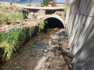
6 Flood 2017 Helmer Lake Dam Cache Creek Guichon Creek
7 BC Flood Management 2003/4 Amended Legislation to Local Authority from Province 2004 BC Flood Hazard Area Land Use Guidelines Designated FPs 30 years ago no longer considered designated Province retained authority for diking oversight Prepared flood guidelines but no standards/regulations ever produced Local Authority responsible for hazard mapping and development approval


8 Landslides 2017 May 6: Debris flow into Shuswap Lake May 14: evacuation order has been issued for 17 properties near West Kelowna Nov 23: Rainfall warning issued for Vancouver, Fraser Valley with up to 150mm expected
 responsible development approval Terrace")
9 Landslide Debris Flow Management 2004 BC Flood Hazard Area Land Use Guidelines Province considers protective works to be authorized under DMA No Provincial landslide guidelines Local Authority (or Provincial Approving Officers) responsible development approval Terrace 2007


10 Landslide Debris Flow Management Land Use Management Guidelines (2004) 3.4 Areas Subject to Debris Flows Development should be discouraged in areas where local knowledge, experience or studies indicate concern that there may be a debris flow hazard Professional Evaluation Consent to develop may be granted, with standard requirements as established for alluvial fans in section 3.3, where: There is no other land available, and Where an assessment of the land by a suitably qualified professional indicates that development may occur safely. Chilcotin River, August 29, 2004

11 Landslide Debris Flow Management What is a Landslide? Debris Flow? Landslide A movement of a mass of rock, debris, or earth down a slope (Cruden 1991). Usual triggering mechanism: Water Seismic Activity Volcanic Activity

12 Why is this happening?

13 Why is this happening?
14 Why is this Happening? Find the susceptible areas or system weak points: Post wildfire changed hydrology, hydrophobic soils Exposed streambanks following past flood. Tufa or other calcareous deposits Past forest practices Culvert placements Systems with little/no redundancies Systems with design compromises Etc.
15 What s Involved Starting Point: Understanding the Hazard Understanding the Consequences or at least what we currently value.

16 What s Involved Included in the process: determine who s included. Engagement: involving the right people to influence project outcomes Build public understanding Draw local knowledge Build public support for project $$$ Avoid contention & delays
 3. Who is your audience? (skills, absent voices) 4. What are public concerns/expectations? (who cares?")
17 What s Involved Participation Select your level of Engagement 1. Client expectations & tolerance (early buy-in) 2. Engagement objectives (desired outcomes) 3. Who is your audience? (skills, absent voices) 4. What are public concerns/expectations? (who cares?) $ $$ $$ $$$ $$$ INFLUENCE OVER OUTCOME
18 Mitigation Strategies Strategy Description Examples Construct and maintain dikes to keep floodwater within the river floodway Protect Protect existing development in its current form and location, balancing costs and increasing vulnerability against societal cost and risk associated with other strategies. Provide erosion protection works to mitigate the potential for channel migration toward developed areas Construct dams and diversions that can attenuate or bypass peak flows Raise land elevation with structural fill Accommodate Accommodate the potential consequences of ongoing changes by changing human activities and/or infrastructure to increase resilience. Raise elevation of habitable uses above riverine flood risk Provide floodproofed ground floor parking below residential/commercial uses Require flood resistant building materials for commercial uses at ground level Retreat Manage Retreat by gradually withdrawing potentially-vulnerable infrastructure and services from hazard areas in recognition of their increasing vulnerability. Allow water dependent industrial uses (e.g., log sort) Reclaim developed area to natural state as a community amenity Existing river floodway Avoid Avoid increasing the presence or density of potentially-vulnerable populations, infrastructure or services within hazard areas. Areas where a dike breach would result in unacceptable risk or consequence Areas where development could exacerbate hazards or risk for others

19 Risk Management: Stepping Down the Risk


20 I have a dream! What is an Integrated Flood Management Framework? Builds on existing templates: Metro Vancouver Integrated Stormwater Management, Squamish IFMP Considers Science, Safety, Environment, Community Values, Economics Is Holistic and Inclusive Balances risks, consequences and costs Assessing Hazards River and creek Lake Stormwater Groundwater Debris flow/flood Seismic Coastal Mitigation Best available to balance risk and consequences Decision Making Look at full range of impacts and benefits Cost to people Benefits to community and environment
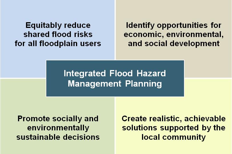
21 IFMP Principles
 IFMP")
22 Flood Tolerance Pressure Community Engagement Risk Vapour Risk Evaluation Tools Consequences Mitigation Condenser Hazards HEAT (Politics, Policy and Funding) IFMP COOLING
23 Take Away Message Flood and Debris Flows will be occurring more often. Risk Assessments are a valuable tool and are needed to complete mitigation efforts. To address these hazards, a wide range of individuals need to be involved.


24 THOMPSON WATERSHED DISASTER MITIGATION COMMUNITY FORUM FEBRUARY 14, 2018 Dwayne Meredith, P.Ag. Kerr Wood Leidal Associates
Delta Flood Protection Strategy Update. May 16, 2016
 Delta Flood Protection Strategy Update May 16, 2016 Presentation Overview 1. Background 2. Understanding the Dike Reaches/Issues 3. Future Dike Improvements 4. Next Steps Boundary Bay Village March 10,
1. INTRODUCTION. EXAMPLE OF SECHILIENNE ROCKFALL (France)
") FORM OSE POST-GRADUATE COURSE Landslide vulnerability and risk 1 FORM OSE POST-GRADUATE COURSE Landslide vulnerability and risk 2 FORM OSE POST-GRADUATE COURSE Landslide vulnerability and risk 3 Christophe
FORM OSE POST-GRADUATE COURSE Landslide vulnerability and risk 1 FORM OSE POST-GRADUATE COURSE Landslide vulnerability and risk 2 FORM OSE POST-GRADUATE COURSE Landslide vulnerability and risk 3 Christophe
They include earthquakes, volcanic eruptions, floods, landslides, and other processes and occurrences. They are included in the broader concept of.
 They include earthquakes, volcanic eruptions, floods, landslides, and other processes and occurrences. They are included in the broader concept of. In general, natural processes are labeled hazardous only
An overview of the applications for early warning and mapping of the flood events in New Brunswick
 Flood Recovery, Innovation and Reponse IV 239 An overview of the applications for early warning and mapping of the flood events in New Brunswick D. Mioc 1, E. McGillivray 2, F. Anton 1, M. Mezouaghi 2,
DEPARTMENT OF GEOLOGY AND MINERAL INDUSTRIES WAYS & MEANS SUBCOMMITTEE ON NATURAL RESOURCES MARCH 2, 2017
 DEPARTMENT OF GEOLOGY AND MINERAL INDUSTRIES WAYS & MEANS SUBCOMMITTEE ON NATURAL RESOURCES MARCH 2, 2017 1 ABOUT DOGAMI AGENCY MISSION, VISION & GOALS 2 Lidar image of a stream network along the Umpqua
Debris flow: categories, characteristics, hazard assessment, mitigation measures. Hariklia D. SKILODIMOU, George D. BATHRELLOS
 Debris flow: categories, characteristics, hazard assessment, mitigation measures Hariklia D. SKILODIMOU, George D. BATHRELLOS Natural hazards: physical phenomena, active in geological time capable of producing
Oregon APA Legal Issues Workshop December 7, Tricia Sears, DLCD With information from Bill Burns, DOGAMI
 Oregon APA Legal Issues Workshop December 7, 2018 Tricia Sears, DLCD With information from Bill Burns, DOGAMI How this Topic Arrived WE FREQUENTLY HEAR CONCERNS ABOUT LIABILITY AND TAKINGS. Current federal
GIS as a tool in flood management
 GIS for the United Nations and the International Community Conference Panel: GIS and Capacity - How Territorial Planning Benefits from Geospatial Information 3-5 April 2012 Geneva, Switzerland GIS as a
Natural hazards in Glenorchy Summary Report May 2010
 Natural hazards in Glenorchy Summary Report May 2010 Contents Glenorchy s hazardscape Environment setting Flood hazard Earthquakes and seismic hazards Hazards Mass movement Summary Glossary Introduction
MINISTRY OF FORESTS, LANDS AND NATURAL RESOURCE OPERATIONS, POST-WILDFIRE RISK ANALYSIS PRELIMINARY REPORT
 MINISTRY OF FORESTS, ANDS AND NATURA RESOURCE OPERATIONS, POST-WIDFIRE RISK ANAYSIS PREIMINARY REPORT NOTE: The results given on this form are preliminary in nature and are intended to be a warning of
Emergency Preparedness Questions
 Emergency Preparedness Questions 1. A family emergency plan should NOT include which of the following? a) Information about your children's school(s) b) The name and phone number of an out-of-town contact
Disaster Risk Assessment: Opportunities for GIS and data management with Open DRI
 Disaster Risk Assessment: Opportunities for GIS and data management with Open DRI Jacob Opadeyi Department of Geomatics Engineering and Land Management, The University of the West Indies, St. Augustine,
Interpretive Map Series 24
 Oregon Department of Geology and Mineral Industries Interpretive Map Series 24 Geologic Hazards, and Hazard Maps, and Future Damage Estimates for Six Counties in the Mid/Southern Willamette Valley Including
APPROACH TO THE SPANISH WATER ORGANISATION IMPROVING FLOOD HAZARD MAPPING, LAWS AND AUTHORITIES COORDINATION
 "Workshop On Land Use Planning And Water Management, With Focus On Flood Risk Management Oslo, Norway. Wednesday 31 January and Thursday 1 February 2007 APPROACH TO THE SPANISH WATER ORGANISATION IMPROVING
EFFECTS OF RIPARIAN RETENTION (IN WATERSHEDS) ON ALLUVIAL FANS
 ON ALLUVIAL FANS") EFFECTS OF RIPARIAN RETENTION (IN WATERSHEDS) ON ALLUVIAL FANS TIM GILES GEOMORPHOLOGIST FLNRO EFFECTS OF RIPARIAN RETENTION (IN WATERSHEDS) ON ALLUVIAL FANS Description of alluvial fans Three case studies
EFFECTS OF RIPARIAN RETENTION (IN WATERSHEDS) ON ALLUVIAL FANS TIM GILES GEOMORPHOLOGIST FLNRO EFFECTS OF RIPARIAN RETENTION (IN WATERSHEDS) ON ALLUVIAL FANS Description of alluvial fans Three case studies
Manitoba s Elevation (LiDAR) & Imagery Datasets. Acquisition Plans & Opportunities for Collaboration
 & Imagery Datasets. Acquisition Plans & Opportunities for Collaboration") Manitoba s Elevation (LiDAR) & Imagery Datasets Acquisition Plans & Opportunities for Collaboration Manitoba Planning Conference May 2017 Presentation Outline Manitoba s Elevation (LiDAR) and Imagery Datasets
Manitoba s Elevation (LiDAR) & Imagery Datasets Acquisition Plans & Opportunities for Collaboration Manitoba Planning Conference May 2017 Presentation Outline Manitoba s Elevation (LiDAR) and Imagery Datasets
FLOOD REPORT FOR MANITOBA. June 28, A Gale wind warning is in effect for Lake Manitoba and Lake Winnipeg
 FLOOD REPORT FOR MANITOBA June 28, 2014 A Gale wind warning is in effect for Lake Manitoba and Lake Winnipeg Flood Warning*: Flood Watch*: High Water Advisory*: - Assiniboine River, from Shellmouth Dam
Programmatic Approaches to Assessing and Mitigating Risk to Pipelines from Natural Forces
 Programmatic Approaches to Assessing and Mitigating Risk to Pipelines from Natural Forces 23 rd International Petroleum Environmental Conference New Orleans, Louisiana November 8-10, 2016 Introduction
Rock & Aggregate Drop Inlet Protection
 Rock & Aggregate Drop Inlet Protection SEDIMENT CONTROL TECHNIQUE Type 1 System Sheet Flow Sandy Soils Type 2 System [1] Concentrated Flow Clayey Soils Type 3 System Supplementary Trap Dispersive Soils
2017 January Conditions Report Manitoba Hydrologic Forecasting and Coordination Branch Manitoba Infrastructure
 2017 January Conditions Report Manitoba Hydrologic Forecasting and Coordination Branch Manitoba Infrastructure 1/30/2017 Page 1 of 22 Hydrologic Forecast Centre Manitoba Infrastructure and Transportation
Hydrologic Forecast Centre. Manitoba Infrastructure. Winnipeg, Manitoba FEBRUARY FLOOD OUTLOOK REPORT FOR MANITOBA.
 Page 1 of 20 Hydrologic Forecast Centre Manitoba Infrastructure Winnipeg, Manitoba FEBRUARY FLOOD OUTLOOK REPORT FOR MANITOBA February 28, 2019 Overview The February Outlook Report prepared by the Hydrologic
Dan Miller + Kelly Burnett, Kelly Christiansen, Sharon Clarke, Lee Benda. GOAL Predict Channel Characteristics in Space and Time
 Broad-Scale Models Dan Miller + Kelly Burnett, Kelly Christiansen, Sharon Clarke, Lee Benda GOAL Predict Channel Characteristics in Space and Time Assess Potential for Fish Use and Productivity Assess
RAILWAYS AND FISH: HOW TO PROTECT AND ENHANCE FISH HABITAT VALUES AT STREAM CROSSINGS THROUGH PROJECT DESIGN AND CONSTRUCTION
 RAILWAYS AND FISH: HOW TO PROTECT AND ENHANCE FISH HABITAT VALUES AT STREAM CROSSINGS THROUGH PROJECT DESIGN AND CONSTRUCTION Rail Environment Conference November 2016 AGENDA Objective Background Benefits
5.2 IDENTIFICATION OF HAZARDS OF CONCERN
 5.2 IDENTIFICATION OF HAZARDS OF CONCERN 2016 HMP Update Changes The 2011 HMP hazard identification was presented in Section 3. For the 2016 HMP update, the hazard identification is presented in subsection
3l NATURAL HAZARDS AND UNSTABLE GROUND
 Page 1 of Section 3l 3l NATURAL HAZARDS AND UNSTABLE GROUND 3l.1 Introduction A natural hazard is the result of natural processes that form, shape and change the environment and interact or potentially
RISK ASSESSMENT COMMUNITY PROFILE NATURAL HAZARDS COMMUNITY RISK PROFILES. Page 13 of 524
 RISK ASSESSMENT COMMUNITY PROFILE NATURAL HAZARDS COMMUNITY RISK PROFILES Page 13 of 524 Introduction The Risk Assessment identifies and characterizes Tillamook County s natural hazards and describes how
APPLICATION TO PAST DISASTERS OF A METHOD OF SETTING THE RANGE OF DEBRIS FLOW DAMAGE TO HOUSES
 APPLICATION TO PAST DISASTERS OF A METHOD OF SETTING THE RANGE OF DEBRIS FLOW DAMAGE TO HOUSES Hideaki MIZUNO Senior Researcher Erosion and Sediment Control National Institute for Land and Infrastructure
The last three sections of the main body of this report consist of:
 Threatened and Endangered Species Geological Hazards Floodplains Cultural Resources Hazardous Materials A Cost Analysis section that provides comparative conceptual-level costs follows the Environmental
9/13/2011 CHAPTER 9 AND SUBSIDENCE. Case History: La Conchita Landslide. Introduction
 CHAPTER 9 SLOPE PROCESSES, LANDSLIDES, AND SUBSIDENCE Case History: La Conchita Landslide La Conchita: small coastal community 80 km (50 mi) northwest of Los Angeles Landslide occurred on January 10, 2005
CASE STUDY #9 - Brushy Fork Dam, Sugar Grove, West Virginia
 CASE STUDY #9 - Brushy Fork Dam, Sugar Grove, West Virginia Brushy Fork Dam is a flood control structure built by the Soil Conservation Service southeast of the city of Franklin in Pendleton County, West
2016 Fall Conditions Report
 2016 Fall Conditions Report Prepared by: Hydrologic Forecast Centre Date: December 13, 2016 Table of Contents TABLE OF FIGURES... ii EXECUTIVE SUMMARY... 1 BACKGROUND... 5 SUMMER AND FALL PRECIPITATION...
New Zealand s Next Top Model: integrating tsunami modelling into land use planning
 New Zealand s Next Top Model: integrating tsunami modelling into land use planning Wendy Saunders (MZNZPI), Gegar Prasetya, Graham Leonard GNS Science, Lower Hutt, w.saunders@gns.cri.nz In April 2011 a
INTRODUCTION. Climate
 INTRODUCTION Climate Landslides are serious natural disasters in many parts of the world. Since the past 30 years, rainfall triggered landslides and debris flows had been one of the natural disasters of
Progress Report. Flood Hazard Mapping in Thailand
 Progress Report Flood Hazard Mapping in Thailand Prepared By: Mr. PAITOON NAKTAE Chief of Safety Standard sub-beuro Disaster Prevention beuro Department of Disaster Prevention and Mitigation THAILAND E-mail:
Assumption Parish Hazard Mitigation Plan Update Public Meeting. September 1, 2015 Napoleonville, LA
 Assumption Parish Hazard Mitigation Plan Update Public Meeting September 1, 2015 Napoleonville, LA Agenda Hazard Mitigation Planning Process SDMI Staff Risk Assessment SDMI Staff Update on Previous/Current
Stream Geomorphology. Leslie A. Morrissey UVM July 25, 2012
 Stream Geomorphology Leslie A. Morrissey UVM July 25, 2012 What Functions do Healthy Streams Provide? Flood mitigation Water supply Water quality Sediment storage and transport Habitat Recreation Transportation
TABLE OF CONTENTS LIST OF TABLES. Page
 TABLE OF CONTENTS Page 11.0 EFFECTS OF THE ENVIRONMENT ON THE PROJECT... 11-1 11.1 Weather Conditions... 11-1 11.2 Flooding... 11-2 11.3 Forest Fires... 11-2 11.4 Permafrost and Subsidence Risk... 11-3
Baldwin County, Alabama
 2015 Baldwin County, Alabama Multi-Hazard Mitigation Plan I. Comprehensive Plan A multi-jurisdiction plan City of Bay Minette City of Daphne Town of Elberta City of Fairhope City of Foley City of Gulf
Attachment 3. Updating UBC s Regional Context Statement. University of British Columbia CONSIDERATION MEMORANDUM OF CONSULTATION INPUT
 Attachment 3 University of British Columbia Updating UBC s Regional Context Statement CONSIDERATION MEMORANDUM OF CONSULTATION INPUT Campus and Community Planning February 24, 2014 1 CONSIDERATION MEMORANDUM
Sediment Disasters and Mass Movement (SD&M 2 ) NATIONAL DISASTER MANAGEMENT RESEARCH INSTITUTE
 NATIONAL DISASTER MANAGEMENT RESEARCH INSTITUTE") Sediment Disasters and Mass Movement (SD&M 2 ) Contents Outline of SD&M 2 Major outcomes Issues and conclusions Prologue Mass movement in Ulsan, Korea by Typhoon CHABA on Oct. 5. Outline of SD&M 2 Activities
Sediment Disasters and Mass Movement (SD&M 2 ) Contents Outline of SD&M 2 Major outcomes Issues and conclusions Prologue Mass movement in Ulsan, Korea by Typhoon CHABA on Oct. 5. Outline of SD&M 2 Activities
Hydrologic Forecast Centre Manitoba Infrastructure, Winnipeg, Manitoba. FEBRUARY OUTLOOK REPORT FOR MANITOBA February 23, 2018
 Page 1 of 17 Hydrologic Forecast Centre Manitoba Infrastructure, Winnipeg, Manitoba FEBRUARY OUTLOOK REPORT FOR MANITOBA February 23, 2018 Overview The February Outlook Report prepared by the Hydrologic
Assessing Hazards and Risk
 Page 1 of 6 EENS 204 Tulane University Natural Disasters Prof. Stephen A. Nelson Assessing Hazards and Risk This page last updated on 07-Jan-2004 As discussed before, natural disasters are produced by
Subcommittee on Sedimentation Draft Sediment Analysis Guidelines for Dam Removal
 Subcommittee on Sedimentation Draft Sediment Analysis Guidelines for Dam Removal August 4, 2011 Jennifer Bountry, M.S., P.E. Tim Randle, M.S., P.E., D.WRE. Blair Greimann, Ph.D., P.E. Sedimentation and
AHEAD OF THE STORM: Extreme Weather Resilience in the City of Toronto
 AHEAD OF THE STORM: Extreme Weather Resilience in the City of Toronto David MacLeod Toronto Environment and Energy Office Environmental Applied Science and Management Symposium 2013 March 21, 2013 Ahead
5.2 IDENTIFICATION OF HAZARDS OF CONCERN
 5.2 IDENTIFICATION OF HAZARDS OF CONCERN To provide a strong foundation for mitigation actions considered in Sections 6 and 9, County focused on considering a full range of s that could impact area, and
Term Knowledge Using and applying Grade Criteria Autumn 1 Assessment window October Natural hazards pose major risks to people and property.
 Assessment Schedule Year 9 2015/6 Term Knowledge Using and applying Grade Criteria Autumn 1 Assessment window October 2015 3.1.1.2 Tectonic Natural hazards pose major risks to people and property. Definition
SHELTER CAPACITY REPORT
 2013-2014 SHELTER CAPACITY REPORT 1 Table of Contents Introduction... 3 Highlights... 4 National Summary: Emergency Homeless Shelters... 5 Emergency Shelters by Clientele Served... 5 Emergency shelters
5.2 IDENTIFICATION OF HAZARDS OF CONCERN
 5.2 IDENTIFICATION OF HAZARDS OF CONCERN 2015 HMP Update Changes The 2010 HMP hazard identification was presented in Section 6. For the 2015 HMP update, the hazard identification is presented in subsection
Modeling Great Britain s Flood Defenses. Flood Defense in Great Britain. By Dr. Yizhong Qu
 Modeling Great Britain s Flood Defenses AIRCurrents Editor s note: AIR launched its Inland Flood Model for Great Britain in December 2008. The hazard module captures the physical processes of rainfall-runoff
International Journal of Modern Trends in Engineering and Research e-issn No.: , Date: April, 2016
 International Journal of Modern Trends in Engineering and Research www.ijmter.com e-issn No.:2349-9745, Date: 28-30 April, 2016 Landslide Hazard Management Maps for Settlements in Yelwandi River Basin,
SECTION II Hydrological risk
 Chapter 3 Understanding disaster risk: hazard related risk issues SECTION II Hydrological risk Peter Salamon Coordinating lead author Hannah Cloke Lead author 3.4 Giuliano di Baldassarre Owen Landeg Florian
12/05/2016. The First step in Adaptation to future climate change Reduce Vulnerability and Exposure to present Climate Variability (IPCC 2014)
") Integrating CCA, DRR and L+D to Address Emerging Challenges due to Slow Onset Processes Joy Jacqueline Pereira (Project Leader), SEADPRI-Universiti Kebangsaan Malaysia, Nguyen Van Thang (Collaborator),
Integrating CCA, DRR and L+D to Address Emerging Challenges due to Slow Onset Processes Joy Jacqueline Pereira (Project Leader), SEADPRI-Universiti Kebangsaan Malaysia, Nguyen Van Thang (Collaborator),
A Roundup of Recent Debris Flow Events in Taiwan
 2015 International Workshop on Typhoon and Flood APEC Experience Sharing on Hazardous Weather Events and Risk Management A Roundup of Recent Debris Flow Events in Taiwan Hsiao-Yuan(Samuel) Yin Ph.D. sammya@mail.swcb.gov.tw
West Carroll Parish Hazard Mitigation Plan Update Public Meeting. August 25, 2015 Oak Grove, LA
 West Carroll Parish Hazard Mitigation Plan Update Public Meeting August 25, 2015 Oak Grove, LA Agenda Hazard Mitigation Planning Process SDMI Staff Risk Assessment SDMI Staff Update on Previous/Current
River Response. Sediment Water Wood. Confinement. Bank material. Channel morphology. Valley slope. Riparian vegetation.
 River Response River Response Sediment Water Wood Confinement Valley slope Channel morphology Bank material Flow obstructions Riparian vegetation climate catchment vegetation hydrological regime channel
MULTI-HAZARD RISK ASSESSMENT AND DECISION MAKING
 MULTI-HAZARD RISK ASSESSMENT AND DECISION MAKING JULINDA KEÇI Epoka University Logo of the institution CONTENT: Introduction Multi Hazard Risks Multi-Hazard Risk Assessment Quantitative Assessment Event
Hazard Resilience Index (HRI) Earthquakes, Tsunamis, and Volcanoes
 Earthquakes, Tsunamis, and Volcanoes") Hazard Index (HRI) Earthquakes, Tsunamis, and Volcanoes Earthquakes Tsunamis Volcano-Ash Falls, Projectiles and Lateral Blasts, Pyroclastic Flows and Lava Flows Earthquakes, Tsunamis and Volcanoes Please
Hazard Index (HRI) Earthquakes, Tsunamis, and Volcanoes Earthquakes Tsunamis Volcano-Ash Falls, Projectiles and Lateral Blasts, Pyroclastic Flows and Lava Flows Earthquakes, Tsunamis and Volcanoes Please
2017 Fall Conditions Report
 2017 Fall Conditions Report Prepared by: Hydrologic Forecast Centre Date: November 15, 2017 Table of Contents TABLE OF FIGURES... ii EXECUTIVE SUMMARY... 1 BACKGROUND... 4 SUMMER AND FALL PRECIPITATION...
Red River Levee Panel
 Red River Levee Panel Mississippi River Commission Monday, August 9, 2017 Red River Levees in LA & AR NONE along TX & OK Boarder Red River Levee Issues Caddo Levee Cherokee Park Authorization Bossier Levee
Risk Evaluation. Todd Shipman PhD, Alberta Geological Survey/Alberta Energy Regulator November 17 th,2017 Induced Seismicity Workshop, Yellowknife NWT
 Risk Evaluation Todd Shipman PhD, Alberta Geological Survey/Alberta Energy Regulator November 17 th,2017 Induced Seismicity Workshop, Yellowknife NWT Risk Management Approach to Induced Seismicity Establishing
Global Map: A Tool for Disaster Mitigation for the Asia and Pacific Region
 Global Map: A Tool for Disaster Mitigation for the Asia and Pacific Region D. R. Fraser Taylor Chair, International Steering Committee for Global Mapping (ISCGM) fraser_taylor@carleton.ca www. 18 th United
Operative Chapter 13 Natural Hazards 31 January 2015 NATURAL HAZARDS
 CHAPTER 13: NATURAL HAZARDS 13.0 INTRODUCTION Natural hazards have the potential to damage property, infrastructure and ecosystems, and threaten health and safety. Remedying the damage can cost individuals
CLIMATE RESILIENT ALTITUDINAL GRADIENTS (CRAGs)
") CLIMATE RESILIENT ALTITUDINAL GRADIENTS (CRAGs) BUILDING CLIMATE CHANGE RESILIENCE IN THE KIVU- RUSIZI WATERSHEDS Great Lake Conference Entebbe 2017 Chris Magero WHAT ARE CRAGs? Climate-Resilient Altitudinal
CLIMATE RESILIENT ALTITUDINAL GRADIENTS (CRAGs) BUILDING CLIMATE CHANGE RESILIENCE IN THE KIVU- RUSIZI WATERSHEDS Great Lake Conference Entebbe 2017 Chris Magero WHAT ARE CRAGs? Climate-Resilient Altitudinal
THE 3D SIMULATION INFORMATION SYSTEM FOR ASSESSING THE FLOODING LOST IN KEELUNG RIVER BASIN
 THE 3D SIMULATION INFORMATION SYSTEM FOR ASSESSING THE FLOODING LOST IN KEELUNG RIVER BASIN Kuo-Chung Wen *, Tsung-Hsing Huang ** * Associate Professor, Chinese Culture University, Taipei **Master, Chinese
Geohazards in the Himalaya GEOL 3000 (3 Credits / 45 class hours)
") Geohazards in the Himalaya GEOL 3000 (3 Credits / 45 class hours) SIT Study Abroad Program: Nepal: Geoscience in the Himalaya PLEASE NOTE: This syllabus represents a recent term. Because courses develop
Geohazards in the Himalaya GEOL 3000 (3 Credits / 45 class hours) SIT Study Abroad Program: Nepal: Geoscience in the Himalaya PLEASE NOTE: This syllabus represents a recent term. Because courses develop
Assessing Climate Change Vulnerability of Cultural Resources
 National Park Service U.S. Department of the Interior Klondike Gold Rush National Historical Park Assessing Climate Change Vulnerability of Cultural Resources Cultural Resources Caitlin Rankin, YLCC Climate
Terms of Reference for the Comparative Environmental Review (CER) of. Options for the Mactaquac Project, Mactaquac, New Brunswick
 of. Options for the Mactaquac Project, Mactaquac, New Brunswick") Terms of Reference for the Comparative Environmental Review (CER) of Options for the Mactaquac Project, Mactaquac, New Brunswick Preamble The New Brunswick Power Corporation ( NB Power ) operates the Mactaquac
Terms of Reference for the Comparative Environmental Review (CER) of Options for the Mactaquac Project, Mactaquac, New Brunswick Preamble The New Brunswick Power Corporation ( NB Power ) operates the Mactaquac
Hydrologic Forecast Centre Manitoba Infrastructure, Winnipeg, Manitoba. MARCH OUTLOOK REPORT FOR MANITOBA March 23, 2018
 Page 1 of 21 Hydrologic Forecast Centre Manitoba Infrastructure, Winnipeg, Manitoba MARCH OUTLOOK REPORT FOR MANITOBA March 23, 2018 Overview The March Outlook Report prepared by the Hydrologic Forecast
Unit 2: The World in Spatial Terms (Lessons 6-7)
") Unit 2: The World in Spatial Terms (Lessons 6-7) Physical Features of Earth Create Challenges and Opportunities The physical features of Earth create both challenges and opportunities for the people living
Unit 2: The World in Spatial Terms (Lessons 6-7) Physical Features of Earth Create Challenges and Opportunities The physical features of Earth create both challenges and opportunities for the people living
Community Discovery Data Questionnaire
 Region III Community Discovery Data Questionnaire Thank you for taking the time to complete this questionnaire. It will provide important information to help FEMA understand flood risk issues in the Conococheague-Opequon
Impacts of Climate Change and Water-Related Disaster Reduction Management in the Asia-Pacific Region
 Impacts of Climate Change and Water-Related Disaster Reduction Management in the Asia-Pacific Region Katumi MUSIAKE Professor, Fukushima University Secretary General, Asia Pacific Association of Hydrology
2015 Fall Conditions Report
 2015 Fall Conditions Report Prepared by: Hydrologic Forecast Centre Date: December 21 st, 2015 Table of Contents Table of Figures... ii EXECUTIVE SUMMARY... 1 BACKGROUND... 2 SUMMER AND FALL PRECIPITATION...
New Service Provided by State Agency in Oregon: Base Flood Elevation Determinations
 New Service Provided by State Agency in Oregon: Base Flood Elevation Determinations Jed Roberts, MS, CFM Flood Mapping Coordinator Oregon Department of Geology and Mineral Industries (DOGAMI) About DOGAMI
International Symposium on Natural Disaster Mitigation. Local vulnerability assessment of landslides and debris flows
 International Symposium on Natural Disaster Mitigation of landslides and debris flows Lessons learnt from Cam Pha town and Van Don district, Quang Ninh province, Vietnam Nguyen Quoc Phi Faculty of Environment
Disaster Management and Spatial Data An Experience of Sri Lanka for Joint project team meeting 2012
 Disaster Management and Spatial Data An Experience of Sri Lanka for Joint project team meeting 2012 1 by Padma Kumara Withana Provincial Surveyor General Uva Province 2 Out line ü Introduction ü Natural
LONG POINT REGION CONSERVATION AUTHORITY
 LONG POINT REGION CONSERVATION AUTHORITY Reference Manual DETERMINATION OF REGULATION LIMITS L o n g P o i n t R e g i o n C o n s e r v a t i o n A u t h o r i t y D e t e r m i n a t i o n o f R e g
Using Weather and Climate Information for Landslide Prevention and Mitigation
 Using Weather and Climate Information for Landslide Prevention and Mitigation Professor Roy C. Sidle Disaster Prevention Research Institute Kyoto University, Japan International Workshop on Climate and
GEOL 1121 Earth Processes and Environments
 GEOL 1121 Earth Processes and Environments Wondwosen Seyoum Department of Geology University of Georgia e-mail: seyoum@uga.edu G/G Bldg., Rm. No. 122 Seyoum, 2015 Chapter 6 Streams and Flooding Seyoum,
Title: Concepts of Flood Risk
 Title: Concepts of Flood Risk Title Prepared by: Dr. Mohammed Abdulkadir and Dr. Micha Werner Outline of presentation Hazards Flood Event Flood losses Classification of floods Flood management Concepts
West Baton Rouge Parish Hazard Mitigation Plan Update Public Meeting. September 9, 2015 Port Allen, LA
 West Baton Rouge Parish Hazard Mitigation Plan Update Public Meeting September 9, 2015 Port Allen, LA Agenda Hazard Mitigation Planning Process SDMI Staff Risk Assessment SDMI Staff Update on Previous/Current
JCOMM-CHy Coastal Inundation Forecasting Demonstration Project (CIFDP)
") WMO World Meteorological Organization Working together in weather, climate and water JCOMM-CHy Coastal Inundation Forecasting Demonstration Project (CIFDP) Coastal Flooding & Vulnerable Populations Coastal
WMO World Meteorological Organization Working together in weather, climate and water JCOMM-CHy Coastal Inundation Forecasting Demonstration Project (CIFDP) Coastal Flooding & Vulnerable Populations Coastal
Geological Survey of Canada Lands and Minerals Sector Natural Resources Canada OneGeology, June 2018
 Geological Survey of Canada Lands and Minerals Sector Natural Resources Canada OneGeology, June 2018 Geological Survey of Canada Mission The Geological Survey of Canada provides public geoscience knowledge
EARTH S SYSTEMS: PROCESSES THAT SHAPE THE EARTH
 9 Week Unit UNIT 2 EARTH S SYSTEMS: PROCESSES THAT SHAPE THE EARTH Fourth Grade Rogers Public Schools : Earth s Systems: Processes that Shape the Earth 9 weeks In this unit, students develop understandings
Improving global coastal inundation forecasting WMO Panel, UR2014, London, 2 July 2014
 Improving global coastal inundation forecasting WMO Panel, UR2014, London, 2 July 2014 Cyclone Sidr, November 2007 Hurricane Katrina, 2005 Prof. Kevin Horsburgh Head of marine physics, UK National Oceanography
3.18 GEOLOGY AND SOILS
 3.18 GEOLOGY AND SOILS This section discusses geologic resource concerns as they relate to the environment, public safety, and project design both during construction and after completion of the project.
COMMUNITY EMERGENCY RESPONSE TEAM FLOODS INTRODUCTION
 INTRODUCTION Floods are one of the most common hazards in the United States. A flood occurs any time a body of water rises to cover what is usually dry land. Flood effects can be local, impacting a neighborhood
Why Hydrological Services are Important to Business
 Why Hydrological Services are Important to Business Dr. David Green Program Manager, Disasters Earth Science Division David.s.green@nasa.gov May 8, 2018 2 Communities and Areas of Intensive Risk Socio-Economic
USING 3D GIS TO ASSESS ENVIRONMENTAL FLOOD HAZARDS IN MINA
 King Fahd University of Petroleum & Minerals College of Environmental Design Geographical Information system USING 3D GIS TO ASSESS ENVIRONMENTAL FLOOD HAZARDS IN MINA Prepared by : Ali AL-Zahrani OUTLINE
August 14, James Bolton 312 Perry Lane Lovingston, VA
 August 14, 2017 James Bolton 312 Perry Lane Lovingston, VA 22949 jrbolton035@gmail.com Department of Environmental Quality Office of Wetlands & Stream Protection P.O. Box 1105 Richmond, VA 23218 comment-acp@deq.virginia.gov
Template for Sediment and Erosion Control Plan General Instructions. Section Instructions
 Template for Sediment and Erosion Control Plan General Instructions Introduction: Soil erosion and sediment deposition from farmlands can contribute to degraded surface water quality. Sediment delivery
New A-Level Physical Geography
 Half Term 1 3.1 Physical Geography: 3.1.5 Hazards: Plate Tectonics This optional section of our specification focuses on the lithosphere and the atmosphere, which intermittently but regularly present natural
This table connects the content provided by Education Perfect to the NSW Syllabus.
 Education Perfect Geography provides teachers with a wide range of quality, engaging and innovative content to drive positive student learning outcomes. Designed by teachers and written by our in-house
CR AAO Bridge. Dead River Flood & Natural Channel Design. Mitch Koetje Water Resources Division UP District
 CR AAO Bridge Dead River Flood & Natural Channel Design Mitch Koetje Water Resources Division UP District Old County Road AAO Bridge Map courtesy of Marquette County Silver Lake Basin McClure Basin
GENERAL. CHAPTER 1 BACKGROUND AND PURPOSE OF THE GUIDELINES Background of the Guidelines Purpose of the Guidelines...
 GENERAL CHAPTER 1 BACKGROUND AND PURPOSE OF THE GUIDELINES... 1 1.1 Background of the Guidelines... 1 1.2 Purpose of the Guidelines... 3 CHAPTER 2 APPLICATION OF THE GUIDELINES... 3 2.1 Potential Users
VULNERABILITY OF WATER SUPPLY TO NATURAL HAZARDS IN JAMAICA
 VULNERABILITY OF WATER SUPPLY TO NATURAL HAZARDS IN JAMAICA RAFI AHMAD rafi.ahmad@uwimona.edu.jm Unit for disaster studies, Department of Geography & Geology, The University of the West Indies, Mona Kingston
Attachment B to Technical Memorandum No.2. Operations Plan of Ross Valley Detention Basins
 Attachment B to Technical Memorandum No.2 Operations Plan of Ross Valley Detention Basins Operations Plan of Ross Valley Detention Basins Stetson Engineers Inc. January 26, 2011 1.0 Introduction Achieving
Flash Flood Guidance System On-going Enhancements
 Flash Flood Guidance System On-going Enhancements Hydrologic Research Center, USA Technical Developer SAOFFG Steering Committee Meeting 1 10-12 July 2017 Jakarta, INDONESIA Theresa M. Modrick Hansen, PhD
Grant 0299-NEP: Water Resources Project Preparatory Facility
 Document Produced under Grant Project Number: 45206 May 2016 Grant 0299-NEP: Water Resources Project Preparatory Facility Final Report Volume 3 East Rapti (1 of 9) Prepared by Pvt. Ltd. For Ministry of
Roles of NGII in successful disaster management
 The Second UN-GGIM-AP Plenary Meeting Roles of NGII in successful disaster management Republic of Korea Teheran Iran 28 October 2013 Sanghoon Lee, Ph.D. NGII Outline Type of Disasters Occur in Korea Practical
9/23/2013. Introduction CHAPTER 7 SLOPE PROCESSES, LANDSLIDES, AND SUBSIDENCE. Case History: La Conchita Landslide
 Introduction CHAPTER 7 SLOPE PROCESSES, LANDSLIDES, AND SUBSIDENCE Landslide and other ground failures posting substantial damage and loss of life In U.S., average 25 50 deaths; damage more than $3.5 billion