Pirai river (Bolivia)
|
|
|
- Raymond Barber
- 5 years ago
- Views:
Transcription
")


1 Pirai river (Bolivia) Confluent of the Amazon river which average discharge is only 6 m3/s, but with peak discharge over 5000 m3/s, a challenge for river basin management and for flood control HYDROEUROPE Prof. Ir. J.J.thisPeters are needed to see picture. VUB Consultant - River specialist
2 How the project began The Pirai river experiences regularly flash floods because of its location along the edge of the Andes (river basin ranging from 2600 m to 250 m) Erosion in the upper catchment produces a lot of sediment that deposits in the lower catchment as an large alluvial fan where the river course changes very often The area of the alluvial fan is an important agricultural area with a relatively (and unimportant ) city of Montero The German Cooperation had a long-term project for designing new types of hydraulic structures to control the stability of the river course, especially in the alluvial fan HYDROEUROPE Prof. Ir. J.J. Peters VUB Consultant - River specialist
3 How the project began In 1983, a flash flood occurred in the Pirai river basin which inundated the (rich part) of the (rich) city of Santa Cruz de la Sierra, the most important economic centre of the country The Bolivian Government requested the assistance of the European Commission for building flood defences along the city (the emergency phase) and to set up a master plan (the long-term management phase), project accepted for financing in 1986 In 1987, a consultancy consortium presented the plans for the city defences at a cost = 220% the available budget based on modelling and theoretical formulas for riverbed scouring HYDROEUROPE Prof. Ir. J.J. Peters VUB Consultant - River specialist

4 Bolivian Amazon Andes mountains HYDROEUROPE Prof. Ir. J.J. Peters VUB Consultant - River specialist

5 Pirai river basin HYDROEUROPE Prof. Ir. J.J. Peters VUB Consultant - River specialist

6 Slopes of the río Pirai, the alluvial fan starts in station 9 (inlet of canal Juan Latino) Middle reach Alluvial fan HYDROEUROPE Prof. Ir. J.J. Peters VUB Consultant - River specialist

7 A turbion in 1992, with velocities higher than 6m/s A meandering flow in a braided river, with very high velocities in only a part of the cross section HYDROEUROPE Prof. Ir. J.J. Peters VUB Consultant - River specialist
8 A very special river The flash floods start from an almost empty river till discharges of the order of thousands cubic meters per second in less than one day The riverbed is very wide ( meters), with cross-sections almost horizontal (bed level variation less than 1 m) The riverbed material observed during dry periods is very fine, about 0.3 mm, what is exceptional for a river with such strong slopes (> 3 m/km), but under the top layer are very coarse materials HYDROEUROPE Prof. Ir. J.J. Peters VUB Consultant - River specialist
9 Modelling this very special river The first 1-D modelling for designing the flood defences required the use of extreme flow resistance coefficients A second modelling for the Master Plan with a different numerical model also needed roughness smoother than glass Nobody could understand, but everybody (or almost) was happy because it had been possible to calibrate the models Observing the river s behaviour, the damages caused by the floods and the peculiar composition of the bed sediments, we suspected a strong reworking of the river bed during the floods HYDROEUROPE Prof. Ir. J.J. Peters VUB Consultant - River specialist
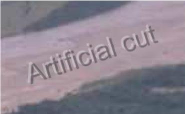
10 Modelling this very special river We designed a system to measure the scouring (erosion) of the riverbed during a flood: coring (drilling tubes) deep into the bed, removing the sediment and replacing it by an artificial sediment (moulded bricks) coloured in red and wait for the flood The idea was that the coloured material would be washed away down to the deepest scouring depth Results from significant (but not extraordinary) floods in 1992 gave fantastic results: the riverbed eroded locally to depths of more than 8 m The change in cross-section geometry makes that water level do not rise very much Modelling the floods with an adapted geometry did not require any adjustment of the roughness coefficients! HYDROEUROPE Prof. Ir. J.J. Peters VUB Consultant - River specialist
 HYDROEUROPE 2007 11 Prof. Ir. J.")
11 Tests by SEARPI of retard structures (to protect the river banks by retarding the flow along these banks) HYDROEUROPE Prof. Ir. J.J. Peters VUB Consultant - River specialist

12 Destruction La Angostura bridge during 1983 flood HYDROEUROPE Prof. Ir. J.J. Peters VUB Consultant - River specialist
13 The role of the Project Adviser The first task was to establish a potamological diagnostic The results of this was that the inundation had not been provoked by overtopping of the banks, but by outflanking of a channel This outflanking had been due to the deflection of the flow by the shape of the opposite bank, itself caused by bank protection structures more upstream The consultant had proposed to build 3 large groynes (big structures), but we instead suggested to correct the shape of the opposite bank, which was done successfully at almost no cost HYDROEUROPE Prof. Ir. J.J. Peters VUB Consultant - River specialist

14 Damages in the City Santa Cruz de la Sierra HYDROEUROPE Prof. Ir. J.J. Peters VUB Consultant - River specialist

15 Damages in the río Pirai (City Santa Cruz de la Sierra) HYDROEUROPE Prof. Ir. J.J. Peters VUB Consultant - River specialist

16 Defensive measures: gabion bank revetment Passage through the levee for crossing by wading HYDROEUROPE Prof. Ir. J.J. Peters VUB Consultant - River specialist

17 Bank revetment with gabion carpets Toe protection length was reduced from 40 to 10 m HYDROEUROPE Prof. Ir. J.J. Peters VUB Consultant - River specialist

18 HYDROEUROPE Prof. Ir. J.J. Peters VUB Consultant - River specialist

19 Correcting river bank alignment Have reduced the risk for attack of the bank HYDROEUROPE Prof. Ir. J.J. Peters VUB Consultant - River specialist

20 Retard structures - permeable groynes Have reduced the velocities along the banks HYDROEUROPE Prof. Ir. J.J. Peters VUB Consultant - River specialist

21 Retard structures - permeable groynes Have reduced the velocities along the banks HYDROEUROPE Prof. Ir. J.J. Peters VUB Consultant - River specialist
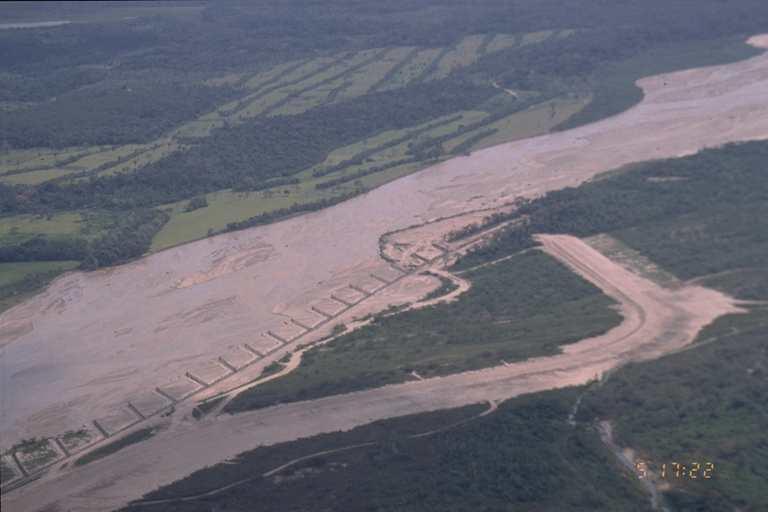
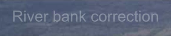


22 Construction of controlled inundation area In an abandoned branch, to store water and sediment River bank correction Permeable groynes Flow guiding structure Weir - dike HYDROEUROPE Prof. Ir. J.J. Peters VUB Consultant - River specialist

23 Construction of controlled inundation area Flow guiding structure HYDROEUROPE Prof. Ir. J.J. Peters VUB Consultant - River specialist


24 Construction of controlled inundation area Evolution of the structure (after one year) HYDROEUROPE Prof. Ir. J.J. Peters VUB Consultant - River specialist

25 HYDROEUROPE Prof. Ir. J.J. Peters VUB Consultant - River specialist

26 HYDROEUROPE Prof. Ir. J.J. Peters VUB Consultant - River specialist

27 Damage by oblique bank attack These aprons in gabions do not resist oblique attack HYDROEUROPE Prof. Ir. J.J. Peters VUB Consultant - River specialist
28 Avulsion phenomena in the alluvial fan The Pirai river has always developed new courses close to the city of Montero that grew quickly due to increased agricultural activities in the area with fine, rich sediments Construction of a road and a railway perpendicular to river courses and drainage system induced upstream sediment retention of sediments (according to Lane balance) Already in 1973, the river had abandoned its bed and was diverted close to the city of Montero A project of the German cooperation brought the river back almost in its previous course HYDROEUROPE Prof. Ir. J.J. Peters VUB Consultant - River specialist

29 HYDROEUROPE Prof. Ir. J.J. Peters VUB Consultant - River specialist
30 Avulsion phenomena in the alluvial fan History of avulsion phenomena in the vicinity of the city of Montero HYDROEUROPE Prof. Ir. J.J. Peters VUB Consultant - River specialist
31 Avulsion phenomena in the alluvial fan Impact of the construction of the road Santa Cruz de la Sierra to Cochabamba and of the Beni railway HYDROEUROPE Prof. Ir. J.J. Peters VUB Consultant - River specialist
32 Avulsion phenomena in the alluvial fan Degradation of the La Madre riverbed (Lane balance) During normal floods, the railway dike worked as a dam HYDROEUROPE Prof. Ir. J.J. Peters VUB Consultant - River specialist
33 Avulsion phenomena in the alluvial fan and produced a breach in the dike The Pirai flow followed then the La Madre river course, producing even more regressive riverbed degradation up to the road HYDROEUROPE Prof. Ir. J.J. Peters VUB Consultant - River specialist
34 Avulsion phenomena in the alluvial fan An extraordinary flood produced an avulsion in an upstream bend, with formation of a kind of a delta, upstream of the road dike HYDROEUROPE Prof. Ir. J.J. Peters VUB Consultant - River specialist
35 Avulsion phenomena in the alluvial fan The excavation of an artificial course in the Juan Latino canal brought the Pirai river back almost in its previous course, although it had insufficient hydraulic capacity for major flood discharges. HYDROEUROPE Prof. Ir. J.J. Peters VUB Consultant - River specialist
36 What did we learn from this project? Inundations are not only due to water levels, also attack and erosion of river banks can be very dangerous (happened in the Var river in 1983 in the Industrial Zone of Carros) Modelling is usually made with the geometry measured after the flood, not during it; the geometry may change a lot but how do we take this into account in the modelling (I have proposed for the Var experiment similar to the one in the Pirai, but this has been considered as not feasible ) Preventive and recurrent measures are often more effective and economic than heavy engineering (but decision makers don t like them because they prefer inaugurate big works) HYDROEUROPE Prof. Ir. J.J. Peters VUB Consultant - River specialist
37 Santa Cruz de la Sierra now HYDROEUROPE Prof. Ir. J.J. Peters VUB Consultant - River specialist

38 Location where the river left its course (Juan Latino, 1990) HYDROEUROPE Prof. Ir. J.J. Peters VUB Consultant - River specialist

39 Location where the river left its course (Juan Latino, 1992) HYDROEUROPE Prof. Ir. J.J. Peters VUB Consultant - River specialist

40 HYDROEUROPE Prof. Ir. J.J. Peters VUB Consultant - River specialist

41 HYDROEUROPE Prof. Ir. J.J. Peters VUB Consultant - River specialist

42 Flood water drained to Montero treatment plant (1992) HYDROEUROPE Prof. Ir. J.J. Peters VUB Consultant - River specialist
 eroded even more the La Madre riverbed River works were build to bring the Pirai river in its previous course HYDROEUROPE 2007 43 Prof. Ir. J.")
43 Drainage to La Madre (1992) The small canal from the Montero treatment plant became the Pirai river and destroyed de road bridges (old and new ones) The flow, free of sediment (retained by the sedimentation upstream from the road dikes) eroded even more the La Madre riverbed River works were build to bring the Pirai river in its previous course HYDROEUROPE Prof. Ir. J.J. Peters VUB Consultant - River specialist

44 Erosion at the main road HYDROEUROPE Prof. Ir. J.J. Peters VUB Consultant - River specialist

45 Destruction of one of the road bridges HYDROEUROPE Prof. Ir. J.J. Peters VUB Consultant - River specialist

46 Reconstruction of the closure works in Juan Latino HYDROEUROPE Prof. Ir. J.J. Peters VUB Consultant - River specialist

47 HYDROEUROPE Prof. Ir. J.J. Peters VUB Consultant - River specialist

48 HYDROEUROPE Prof. Ir. J.J. Peters VUB Consultant - River specialist

49 Reconstruction of the closure works in Juan Latino HYDROEUROPE Prof. Ir. J.J. Peters VUB Consultant - River specialist


50 Avulsion of the Pirai in La Madre HYDROEUROPE Prof. Ir. J.J. Peters VUB Consultant - River specialist

51 HYDROEUROPE Prof. Ir. J.J. Peters VUB Consultant - River specialist

52 Avulsion of the Pirai in La Madre La Madre Pirai HYDROEUROPE Prof. Ir. J.J. Peters VUB Consultant - River specialist

53 Collapse of the railway bridge in La Madre river HYDROEUROPE Prof. Ir. J.J. Peters VUB Consultant - River specialist

54 Railway bridge useless above earlier Pirai riverbed HYDROEUROPE Prof. Ir. J.J. Peters VUB Consultant - River specialist

55 Splay phenomenon in the new canal Juan Latino HYDROEUROPE Prof. Ir. J.J. Peters VUB Consultant - River specialist

56 HYDROEUROPE Prof. Ir. J.J. Peters VUB Consultant - River specialist

57 Formation of meanders in the new canal Juan Latino HYDROEUROPE Prof. Ir. J.J. Peters VUB Consultant - River specialist

58 HYDROEUROPE Prof. Ir. J.J. Peters VUB Consultant - River specialist
A STUDY OF LOCAL SCOUR AT BRIDGE PIERS OF EL-MINIA
 A STUDY OF LOCAL SCOUR AT BRIDGE PIERS OF EL-MINIA Dr. Gamal A. Sallam 1 and Dr. Medhat Aziz 2 ABSTRACT Bridges are critical structures that require a substantial investment to construct and serve an important
SCOUR AND EROSION ALONGSIDE BANK PROTECTION WORK: CASE STUDIES FROM BANGLADESH
 SCOUR AND EROSION ALONGSIDE BANK PROTECTION WORK: CASE STUDIES FROM BANGLADESH KNUT OBERHAGEMANN Northwest Hydraulic Consultants Lt. 4823 99 th Street Edmonton, Alberta T6E 4Y1, Canada ABDUN NOOR Bangladesh
Countermeasure Calculations and Design
 Countermeasure Calculations and Design Summarized from Bridge Scour and Stream Instability Countermeasures, Experience, Selection, and Design Guidance, Second Edition, Publication No. FHWA NHI 01-003,
Vetiver System for Stream Bank Stabilisation. Paul Truong
 Vetiver System for Stream Bank Stabilisation (With special references to the river and canal bank stabilisation in Australia and Vietnam) Paul Truong Director, The Vetiver Network International, Veticon
Appendix A Flood Damages in 2013
 Appendix A Flood Damages in 2013 RPT2-2014-07-09-App_A_Highwood_River_Flood_Damage_In_2013.Docx Table of Contents page Sign-Off 1. Flood Damage in 2013... 1 1.1 Background... 1 1.2 Town of High River...
[1] Performance of the sediment trap depends on the type of outlet structure and the settling pond surface area.
![[1] Performance of the sediment trap depends on the type of outlet structure and the settling pond surface area.](/thumbs/76/74245181.jpg "[1] Performance of the sediment trap depends on the type of outlet structure and the settling pond surface area.") Sediment Trench SEDIMENT CONTROL TECHNIQUE Type 1 System Sheet Flow Sandy Soils Type 2 System [1] Concentrated Flow Clayey Soils Type 3 System [1] Supplementary Trap Dispersive Soils [1] Performance of
Sediment Trench SEDIMENT CONTROL TECHNIQUE Type 1 System Sheet Flow Sandy Soils Type 2 System [1] Concentrated Flow Clayey Soils Type 3 System [1] Supplementary Trap Dispersive Soils [1] Performance of
WATER ON AND UNDER GROUND. Objectives. The Hydrologic Cycle
 WATER ON AND UNDER GROUND Objectives Define and describe the hydrologic cycle. Identify the basic characteristics of streams. Define drainage basin. Describe how floods occur and what factors may make
Upper Drac River restoration project
 Upper Drac River restoration project Restoration of a braided river bed incised in clay substratum through sediment reloading and bed widening SHF Conference, Nantes, 6 & 7 october 2014 Small scale morphological
Streams. Water. Hydrologic Cycle. Geol 104: Streams
 Streams Why study streams? Running water is the most important geologic agent in erosion, transportation and deposition of sediments. Water The unique physical and chemical properties of water make it
GEOL 1121 Earth Processes and Environments
 GEOL 1121 Earth Processes and Environments Wondwosen Seyoum Department of Geology University of Georgia e-mail: seyoum@uga.edu G/G Bldg., Rm. No. 122 Seyoum, 2015 Chapter 6 Streams and Flooding Seyoum,
Hydro-engineers.ch HEC-RAS ANALAYSIS. River: L Aïre Mesfin Tewolde. Hydro-engineers.ch 23 oct. 2017
 Hydro-engineers.ch HEC-RAS ANALAYSIS River: L Aïre Mesfin Tewolde 17 Hydro-engineers.ch 23 oct. 2017 PREPARED BY MESFIN TEWOLDE [TEMPORARY MISSION] Hydro-engineers.ch HEC-RAS ANALYSIS [January- March 2014]
Strategies for managing sediment in dams. Iwona Conlan Consultant to IKMP, MRCS
 Strategies for managing sediment in dams Iwona Conlan Consultant to IKMP, MRCS 1 Sediment trapping by dams Active storage capacity Dead storage coarse material (bed load) Fine materials (suspension) Francis
Why Geomorphology for Fish Passage
 Channel Morphology - Stream Crossing Interactions An Overview Michael Love Michael Love & Associates mlove@h2odesigns.com (707) 476-8938 Why Geomorphology for Fish Passage 1. Understand the Scale of the
IMPACTS OF SECONDARY FLOOD EMBANKMENTS ON THE WAIMAKARIRI FLOODPLAIN, NEW ZEALAND
 IMPACTS OF SECONDARY FLOOD EMBANKMENTS ON THE WAIMAKARIRI FLOODPLAIN, NEW ZEALAND Terry van Kalken (1), Tony Oliver (2), Ian Heslop (2), Tony Boyle (2) (1) DHI Water & Environment, e-centre, Oaklands Road,
6.11 Naas River Management Unit
 6.11 Naas River Management Unit 6.11.1 Site 41 Issue: Bed and bank erosion Location: E 0685848 N 6058358 Waterway: Naas River Management Unit: Naas River Facing downstream from Bobeyan Rd bridge Facing
HYDRAULIC STRUCTURES, EQUIPMENT AND WATER DATA ACQUISITION SYSTEMS - Vol. I - Hydraulics of Two-Phase Flow: Water and Sediment - G R Basson
 HYDRAULICS OF TWO-PHASE FLOWS: WATER AND SEDIMENT G R Basson Dept. of Civil Engineering, University of Stellenbosch, South Africa. Keywords: sediment, sediment transport, turbulence, river regime, stream
STUDY GUIDE FOR CONTENT MASTERY. Surface Water Movement
 Surface Water SECTION 9.1 Surface Water Movement In your textbook, read about surface water and the way in which it moves sediment. Complete each statement. 1. An excessive amount of water flowing downslope
Modeling Great Britain s Flood Defenses. Flood Defense in Great Britain. By Dr. Yizhong Qu
 Modeling Great Britain s Flood Defenses AIRCurrents Editor s note: AIR launched its Inland Flood Model for Great Britain in December 2008. The hazard module captures the physical processes of rainfall-runoff
Hydraulics Prof. Dr. Arup Kumar Sarma Department of Civil Engineering Indian Institute of Technology, Guwahati
 Hydraulics Prof. Dr. Arup Kumar Sarma Department of Civil Engineering Indian Institute of Technology, Guwahati Module No. # 04 Gradually Varied Flow Lecture No. # 07 Rapidly Varied Flow: Hydraulic Jump
Chapter 10. Running Water aka Rivers. BFRB Pages
 Chapter 10 Running Water aka Rivers BFRB Pages 101-116 Stream Erosion and Transportation Running water is all precipitation (rain, snow, etc) that falls on Earth and is pulled downhill by gravity. Running
Surface Water Short Study Guide
 Name: Class: Date: Surface Water Short Study Guide Multiple Choice Identify the letter of the choice that best completes the statement or answers the question. 1. The three ways in which a stream carries
Degradation Concerns related to Bridge Structures in Alberta
 Degradation Concerns related to Bridge Structures in Alberta Introduction There has been recent discussion regarding the identification and assessment of stream degradation in terms of how it relates to
STABILIZATION OF THE H&CT RAILWAY STONE DAM WALTER E. SKIPWITH, PE, JOYCE CRUM, AIA AND JOHN BAUMGARTNER, PE. Introduction.
 STABILIZATION OF THE H&CT RAILWAY STONE DAM WALTER E. SKIPWITH, PE, JOYCE CRUM, AIA AND JOHN BAUMGARTNER, PE I. A. Introduction General The Old Stone Dam is located in the upper reach of Cottonwood Creek
FLUVIAL LANDFORMS. Floodplains
 FLUVIAL LANDFORMS Floodplains fairly flat & continuous surface occupying much of a valley bottom normally underlain by unconsolidated sediments subject to periodic flooding (usually once every year or
Chapter 11. Rivers: Shaping our landscape
 Chapter 11 Rivers: Shaping our landscape Learning outcomes In this presentation you will learn: Common terms associated with rivers About the three stages of a river About the processes of river erosion
Streams. Stream Water Flow
 CHAPTER 14 OUTLINE Streams: Transport to the Oceans Does not contain complete lecture notes. To be used to help organize lecture notes and home/test studies. Streams Streams are the major geological agents
NATURAL RIVER. Karima Attia Nile Research Institute
 NATURAL RIVER CHARACTERISTICS Karima Attia Nile Research Institute NATURAL RIVER DEFINITION NATURAL RIVER DEFINITION Is natural stream of water that flows in channels with ih more or less defined banks.
27. Running Water I (p ; )
") 27. Running Water I (p. 424-436; 440-444) Hydrosphere How much of the Earth s surface is covered by water? Earth's water is collectively called the and is stored in a number of so-called as follows: 1.
27. Running Water I (p. 424-436; 440-444) Hydrosphere How much of the Earth s surface is covered by water? Earth's water is collectively called the and is stored in a number of so-called as follows: 1.
Aquifer an underground zone or layer of sand, gravel, or porous rock that is saturated with water.
 Aggradation raising of the streambed by deposition that occurs when the energy of the water flowing through a stream reach is insufficient to transport sediment conveyed from upstream. Alluvium a general
Earth Science Chapter 6 Section 2 Review
 Name: Class: Date: Earth Science Chapter 6 Section Review Multiple Choice Identify the choice that best completes the statement or answers the question. 1. Most streams carry the largest part of their
Historical channel change on the Upper Gila River, Arizona and New Mexico in response to anthropogenic modifications and extreme floods
 Historical channel change on the Upper Gila River, Arizona and New Mexico in response to anthropogenic modifications and extreme floods www.archives.gov www.paztcn.wr.usgs.gov wrh.noaa.gov Upper Gila River
Summary. Streams and Drainage Systems
 Streams and Drainage Systems Summary Streams are part of the hydrologic cycle and the chief means by which water returns from the land to the sea. They help shape the Earth s surface and transport sediment
The influence of a dam on the downstream degradation of a river bed: case study of the Tigris River
 Hydrology in Mountainous Regions. II - Artificial Reservoirs; Water and Slopes (Proceedings of two Lausanne Symposia, August 1990). IAHS Publ. no. 194, 1990. The influence of a dam on the downstream degradation
Optimization of Alignment of Proposed Canal and Revetment in the old Madhumati River Using Physical Modelling: A Case Study
 International Journal of Hydraulic Engineering 2014, 3(2): 68-75 DOI: 10.5923/j.ijhe.20140302.03 Optimization of Alignment of Proposed Canal and Revetment in the old Madhumati River Using Physical Modelling:
3/3/2013. The hydro cycle water returns from the sea. All "toilet to tap." Introduction to Environmental Geology, 5e
 Introduction to Environmental Geology, 5e Running Water: summary in haiku form Edward A. Keller Chapter 9 Rivers and Flooding Lecture Presentation prepared by X. Mara Chen, Salisbury University The hydro
GY 111 Lecture Note Series Sedimentary Environments 2: Rivers and Deltas
 GY 111 Lecture Notes D. Haywick (2008-09) 1 GY 111 Lecture Note Series Sedimentary Environments 2: Rivers and Deltas Lecture Goals A) Rivers and Deltas (types) B) Water Flow and sedimentation in river/deltas
Morphological Changes of Reach Two of the Nile River
 ICHE 2014, Hamburg - Lehfeldt & Kopmann (eds) - 2014 Bundesanstalt für Wasserbau ISBN 978-3-939230-32-8 Morphological Changes of Reach Two of the Nile River E. Said Egyptian Environmental Affairs Agency,
HYDRAULIC MODELLING OF NENJIANG RIVER FLOODPLAIN IN NORTHEAST CHINA
 HYDRAULIC MODELLING OF NENJIANG RIVER FLOODPLAIN IN NORTHEAST CHINA Xiao Fei MEE08181 Supervisor: A.W. Jayawardena ABSTRACT In 1998, the worst flood recorded for over 200 years hit the Songhua River Basin
MATHEMATICAL MODELING OF FLUVIAL SEDIMENT DELIVERY, NEKA RIVER, IRAN. S.E. Kermani H. Golmaee M.Z. Ahmadi
 JOURNAL OF ENVIRONMENTAL HYDROLOGY The Electronic Journal of the International Association for Environmental Hydrology On the World Wide Web at http://www.hydroweb.com VOLUME 16 2008 MATHEMATICAL MODELING
Rebuilding Flood-Conscious Society
 A zone where strong flood flow or river bank erosion by levee breach are anticipated, which likely to occur collapsing/washing away of house. Set up the joint councils by relative stakeholders(river managers,
Lab 13: Fluvial Processes and Landforms
 Name: Lab 13: Fluvial Processes and Landforms Geomorphology is the study of Earth s surface and of the processes acting to shape it. Streams, for example, are significant continental land-shaping agents.
Learning Objectives: I can identify and interpret river flows and directions.
 Learning Objectives: I can identify and interpret river flows and directions. Bellringer Review: Check for Understanding Questions: 1 2 What Are The Key Parts Of A River s Anatomy? In your data notebooks
GLG362/GLG598 Geomorphology K. Whipple October, 2009 I. Characteristics of Alluvial Channels
 I. Characteristics of Alluvial Channels Self-formed morphology set by entrainment, transport, and deposition They move unconsolidated sedimentary materials present in the valley fill flood plain/bank flow
Running Water Earth - Chapter 16 Stan Hatfield Southwestern Illinois College
 Running Water Earth - Chapter 16 Stan Hatfield Southwestern Illinois College Hydrologic Cycle The hydrologic cycle is a summary of the circulation of Earth s water supply. Processes involved in the hydrologic
Flooding in Dolgellau
 Flooding in Dolgellau Graham Hall MMath, PhD University of Wales, Bangor Background Flooding has historically been a cause for concern in Dolgellau. Following a serious flood in December 1964 when shops
SCOPE OF PRESENTATION STREAM DYNAMICS, CHANNEL RESTORATION PLANS, & SEDIMENT TRANSPORT ANALYSES IN RELATION TO RESTORATION PLANS
 DESIGN METHODS B: SEDIMENT TRANSPORT PROCESSES FOR STREAM RESTORATION DESIGN PETER KLINGEMAN OREGON STATE UNIVERSITY CIVIL ENGINEERING DEPT., CORVALLIS 2 ND ANNUAL NORTHWEST STREAM RESTORATION DESIGN SYMPOSIUM
Fresh Water: Streams, Lakes Groundwater & Wetlands
 Fresh Water:, Lakes Groundwater & Wetlands Oct 27 Glaciers and Ice Ages Chp 13 Nov 3 Deserts and Wind and EXAM #3 Slope hydrologic cycle P = precip I = precip intercepted by veg ET = evapotranspiration
11/12/2014. Running Water. Introduction. Water on Earth. The Hydrologic Cycle. Fluid Flow
 Introduction Mercury, Venus, Earth and Mars share a similar history, but Earth is the only terrestrial planet with abundant water! Mercury is too small and hot Venus has a runaway green house effect so
HYDROLOGY AND HYDRAULICS MUSKEG RIVER BRIDGE
 PUBLIC WORKS CANADA HYDROLOGY AND HYDRAULICS MUSKEG RIVER BRIDGE KILOMETRE 207.9, LIARD HIGKWAY December 1978 I I f I I I I # Bolter Parish Trimble Ltd. ONLIULTINO Public Works, Canada, 9925-109 Street,
LEVEE DESIGN FOR FLOOD PROTECTION ON ALLUVIAL FANS
 LEVEE DESIGN FOR FLOOD PROTECTION ON ALLUVIAL FANS BRUCE M. PHILLIPS 1 ABSTRACT The dynamic nature of alluvial fans in arid environments offers numerous floodplain management challenges primarily due to
Nipigon River Landslide, Ontario, Canada
 Nipigon River Landslide, Ontario, Canada A. Abdelaziz, S. Besner, R. Boger, B. Fu, J. Deng, and A. Farina Presenter: Jian Deng, Ph.D, P.Eng Centre of Excellence for Sustainable Mining and Exploration,
Year 6. Geography. Revision
 Year 6 Geography Revision November 2017 Rivers and World knowledge How the water cycle works and the meaning of the terms evaporation, condensation, precipitation, transpiration, surface run-off, groundwater
The last three sections of the main body of this report consist of:
 Threatened and Endangered Species Geological Hazards Floodplains Cultural Resources Hazardous Materials A Cost Analysis section that provides comparative conceptual-level costs follows the Environmental
STREAM SYSTEMS and FLOODS
 STREAM SYSTEMS and FLOODS The Hydrologic Cycle Precipitation Evaporation Infiltration Runoff Transpiration Earth s Water and the Hydrologic Cycle The Hydrologic Cycle The Hydrologic Cycle Oceans not filling
Precipitation Evaporation Infiltration Earth s Water and the Hydrologic Cycle. Runoff Transpiration
 STREAM SYSTEMS and FLOODS The Hydrologic Cycle Precipitation Evaporation Infiltration Earth s Water and the Hydrologic Cycle Runoff Transpiration The Hydrologic Cycle The Hydrologic Cycle Oceans not filling
CHANGES OF RUNOFF MECHANISM OF THE BRANTAS RIVER OVER THE PAST 30 YEARS
 CHANGES OF RUNOFF MECHANISM OF THE BRANTAS RIVER OVER THE PAST 30 YEARS TOSHIKATSU OMACHI Infrastructure Development Institute KATUMI MUSIAKE Fukushima University The Brantas River in the East Java originates
What do you need for a Marathon?
 What do you need for a Marathon? Water and a snack? What about just a normal day? 1 flush = 3.5 gallons 1 flush = 3.5 gallons 10 minute shower = 20 gal 1 flush = 3.5 gallons 10 minute shower = 20 gal Jeans
4.17 Spain. Catalonia
 4.17 Spain Catalonia In Spain, inundation studies are the responsibility of the respective Hydrographic Confederations of each river basin (River Basin Authorities). The actual status of inundation studies
PART 2:! FLUVIAL HYDRAULICS" HYDROEUROPE
 PART 2:! FLUVIAL HYDRAULICS" HYDROEUROPE 2009 1 HYDROEUROPE 2009 2 About shear stress!! Extremely complex concept, can not be measured directly!! Computation is based on very primitive hypotheses that
Technical Memorandum No
 Pajaro River Watershed Study in association with Technical Memorandum No. 1.2.10 Task: Evaluation of Four Watershed Conditions - Sediment To: PRWFPA Staff Working Group Prepared by: Gregory Morris and
Laboratory Investigation of Submerged Vane Shapes Effect on River Banks Protection
 Australian Journal of Basic and Applied Sciences, 5(12): 1402-1407, 2011 ISSN 1991-8178 Laboratory Investigation of Submerged Vane Shapes Effect on River Banks Protection Touraj Samimi Behbahan Department
Surface Water and Stream Development
 Surface Water and Stream Development Surface Water The moment a raindrop falls to earth it begins its return to the sea. Once water reaches Earth s surface it may evaporate back into the atmosphere, soak
Science EOG Review: Landforms
 Mathematician Science EOG Review: Landforms Vocabulary Definition Term canyon deep, large, V- shaped valley formed by a river over millions of years of erosion; sometimes called gorges (example: Linville
CHAPTER 07 CANAL DESIGN
 CHAPTER 07 CANAL DESIGN Dr. M. R. Kabir Professor and Head, Department of Civil Engineering University of Asia Pacific (UAP), Dhaka LECTURE 17 Canal Design Types Canal Design Drainage Channel Design Irrigation
Flash flood disaster in Bayangol district, Ulaanbaatar
 Flash flood disaster in Bayangol district, Ulaanbaatar Advanced Training Workshop on Reservoir Sedimentation Management 10-16 October 2007. IRTCES, Beijing China Janchivdorj.L, Institute of Geoecology,MAS
Erosion and Deposition
 CHAPTER 3 LESSON 2 Erosion and Deposition Landforms Shaped by Water and Wind Key Concepts What are the stages of stream development? How do water erosion and deposition change Earth s surface? How do wind
Technical Memorandum No Sediment Model
 Pajaro River Watershed Study in association with Technical Memorandum No. 1.2.9 Sediment Model Task: Development of Sediment Model To: PRWFPA Staff Working Group Prepared by: Gregory Morris and Elsie Parrilla
The Effects of Hydraulic Structures on Streams Prone to Bank Erosion in an Intense Flood Event: A Case Study from Eastern Hokkaido
 Symposium Proceedings of the INTERPRAENENT 2018 in the Pacific Rim The Effects of Hydraulic Structures on Streams Prone to Bank Erosion in an Intense Flood Event: A Case Study from Eastern Hokkaido Daisuke
Erosion Surface Water. moving, transporting, and depositing sediment.
 + Erosion Surface Water moving, transporting, and depositing sediment. + Surface Water 2 Water from rainfall can hit Earth s surface and do a number of things: Slowly soak into the ground: Infiltration
SUSTAINABLE SEDIMENT MANAGEMENT
 SUSTAINABLE SEDIMENT MANAGEMENT Shaping our world A company of OUR EXPERTISE Sediments can make or break a Project Numerous examples of dams and reservoirs can be found throughout the world whose live
Environmental Geology Chapter 9 Rivers and Flooding
 Environmental Geology Chapter 9 Rivers and Flooding Flooding in Pakistan 2010-1600 killed/20000 affected The hydrologic cycle is powered by the Sun The cycle includes evaporation, precipitation, infiltration,
Dolores River Watershed Study
 CHAPTER 4: RIVER AND FLOODPLAIN ISSUES The Dolores River falls into a category of streams in Colorado that share some unique characteristics. Like some other mountain streams in the state, it has a steep
Deposition and Resuspension of Sediments in Near Bank Water Zones of the River Elbe
 9th International Congress on Environmental Modelling and Software Brigham Young University BYU ScholarsArchive 4th International Congress on Environmental Modelling and Software - Barcelona, Catalonia,
Final Exam. Running Water Erosion and Deposition. Willamette Discharge. Running Water
 Final Exam Running Water Erosion and Deposition Earth Science Chapter 5 Pages 120-135 Scheduled for 8 AM, March 21, 2006 Bring A scantron form A calculator Your 3 x 5 paper card of formulas Review questions
FOLLOW-UP ON CHANNELIZATION IN SPRING CREEK SUB-WATERSHED
 FOLLOW-UP ON CHANNELIZATION IN SPRING CREEK SUB-WATERSHED Justin R. Beebe, Department of Earth Sciences, University of South Alabama, Mobile, AL 36688. jrb308@jaguar1.usouthal.edu. Spring Creek is a tributary
Rock & Aggregate Drop Inlet Protection
 Rock & Aggregate Drop Inlet Protection SEDIMENT CONTROL TECHNIQUE Type 1 System Sheet Flow Sandy Soils Type 2 System [1] Concentrated Flow Clayey Soils Type 3 System Supplementary Trap Dispersive Soils
Evaluation of Scour Depth around Bridge Piers with Various Geometrical Shapes
 Evaluation of Scour Depth around Bridge Piers with Various Geometrical Shapes Dr. P. D. Dahe * Department of Civil Engineering, SGGSIE&T, Vishnupuri, Nanded (Maharashtra) S. B. Kharode Department of Civil
Case Study: Hydraulic Model Study for Abandoned Channel Restoration
 Engineering, 2013, 5, 989-996 Published Online December 2013 (http://www.scirp.org/journal/eng) http://dx.doi.org/10.4236/eng.2013.512120 Case Study: Hydraulic Model Study for Abandoned Channel Restoration
Rivers T. Perron
 1 Rivers T. Perron 12.001 After our discussions of large-scale topography, how we represent topography in maps, and how topography interacts with geologic structures, you should be frothing at the mouth
Rock Sizing for Waterway & Gully Chutes
 Rock Sizing for Waterway & Gully Chutes WATERWAY MANAGEMENT PRACTICES Photo 1 Rock-lined waterway chute Photo 2 Rock-lined gully chute 1. Introduction A waterway chute is a stabilised section of channel
Stream Restoration and Environmental River Mechanics. Objectives. Pierre Y. Julien. 1. Peligre Dam in Haiti (deforestation)
") Stream Restoration and Environmental River Mechanics Pierre Y. Julien Malaysia 2004 Objectives Brief overview of environmental river mechanics and stream restoration: 1. Typical problems in environmental
Stream Restoration and Environmental River Mechanics Pierre Y. Julien Malaysia 2004 Objectives Brief overview of environmental river mechanics and stream restoration: 1. Typical problems in environmental
River Structural Works and Operation. River Training Works (by Teshome Seyoum)
") River Structural Works and Operation River Training Works (by Teshome Seyoum) Table of contents Chapter Five 5.0.River Training Works 5.1.Objectives: 5.1.1 Classification Of River Training Works: 5.2 Site
River Structural Works and Operation River Training Works (by Teshome Seyoum) Table of contents Chapter Five 5.0.River Training Works 5.1.Objectives: 5.1.1 Classification Of River Training Works: 5.2 Site
Controlling Processes That Change Land
 1 Name Date Controlling Processes That Change Land People try to control some of the processes that change land. To do this, people apply technology- the use of science to solve problems in everyday life.
Summary of Hydraulic and Sediment-transport. Analysis of Residual Sediment: Alternatives for the San Clemente Dam Removal/Retrofit Project,
 Appendix N SUMMARY OF HYDRAULIC AND SEDIMENT-TRANSPORT ANALYSIS OF RESIDUAL SEDIMENT: ALTERNATIVES FOR THE SAN CLEMENTE DAM REMOVAL/RETROFIT PROJECT, CALIFORNIA the San Clemente Dam Removal/Retrofit Project,
Birecik Dam & HEPP Downstream River Arrangement R. Naderer, G. Scharler Verbundplan GmbH, 5021 Salzburg, Austria
 Birecik Dam & HEPP Downstream River Arrangement R. Naderer, G. Scharler Verbundplan GmbH, 5021 Salzburg, Austria e-mail: scharlerg@verbund.co.at Abstract Birecik Dam & HEPP on the Euphrates river in Turkey
DOMINANT DISCHARGE IN THE KOR RIVER, FARS PROVINCE, IRAN
 Tenth International Water Technology Conference, IWTC10 2006, Alexandria, Egypt 299 DOMINANT DISCHARGE IN THE KOR RIVER, FARS PROVINCE, IRAN Keshavarzi Ali Reza 1 and Nabavi, S. H. 2 1 Associate Prof.,
MEMORANDUM 1. INTRODUCTION
 MEMORANDUM TO: Jim Well, Ducks Unlimited FROM: Mike Harvey, PhD, PG, Bob Mussetter, PhD, PE, Dai Thomas, PE SUBJECT: Two-dimensional Sediment-transport Modeling of the M&T/Llano Project No. US-CA-62-2
Each basin is surrounded & defined by a drainage divide (high point from which water flows away) Channel initiation
 Channel initiation") DRAINAGE BASINS A drainage basin or watershed is defined from a downstream point, working upstream, to include all of the hillslope & channel areas which drain to that point Each basin is surrounded &
DRAINAGE BASINS A drainage basin or watershed is defined from a downstream point, working upstream, to include all of the hillslope & channel areas which drain to that point Each basin is surrounded &
A SIMPLE GIS METHOD FOR OBTAINING FLOODED AREAS
 A SIMPLE GIS METHOD FOR OBTAINING FLOODED AREAS ROMAN P., I. 1, OROS C., R. 2 ABSTRACT. A simple GIS method for obtaining flooded areas. This paper presents a method for obtaining flooded areas near to
PRESSURE AND SCOURING AROUND A SPUR DIKE DURING THE SURGE PASS
 Annual Journal of Hydraulic Engineering, JSCE, Vol.3, 3, February PRESSURE AND SCOURING AROUND A SPUR DIKE DURING THE SURGE PASS Tomasz MIODUSZEWSKI and Shiro MAENO Student Member of JSCE, Doctoral Student,
Year 8 Practice Questions for Summative Assessment. NAME:...
 Year 8 Practice Questions for Summative Assessment. NAME:... Earthquakes and Volcanoes 1. (a) The diagram below shows a simple cross section of the Earth. Complete the labels. (b) Name an earthquake you
CONSIDERATIONS ON URBAN AREAS AND FLOATING DEBRIS IN DAM -BREAK FLOOD MODELLING. Peter Reiter *)
") 1 CONSIDERATIONS ON URBAN AREAS AND FLOATING DEBRIS IN DAM -BREAK FLOOD MODELLING. Peter Reiter *) 1. SUMMARY Every model is a story, describing real-life and more or less significant simplifications are
1 CONSIDERATIONS ON URBAN AREAS AND FLOATING DEBRIS IN DAM -BREAK FLOOD MODELLING. Peter Reiter *) 1. SUMMARY Every model is a story, describing real-life and more or less significant simplifications are
Texas A & M University and U.S. Bureau of Reclamation Hydrologic Modeling Inventory Model Description Form
 Texas A & M University and U.S. Bureau of Reclamation Hydrologic Modeling Inventory Model Description Form JUNE, 1999 Name of Model: Two-Dimensional Alluvial River and Floodplain Model (MIKE21 CHD & CST)
GLG598 Surface Processes and Landform Evolution K. Whipple Fall 2012 VERDE RIVER: FLOW MECHANICS, ROUGHNESS, AND SHEAR STRESS
 VERDE RIVER: FLOW MECHANICS, ROUGHNESS, AND SHEAR STRESS This lab will introduce you to some common field techniques and some general understanding of the geomorphic processes operating in a stream. The
River Meandering and Braiding. Pierre Y. Julien. Department of Civil and Environmental Engineering Colorado State University Fort Collins, Colorado
 River Meandering and Braiding Pierre Y. Julien Department of Civil and Environmental Engineering Colorado State University Fort Collins, Colorado River Mechanics and Sediment Transport Lima Peru January
HAW CREEK, PIKE COUNTY, MISSOURI-TRIB TO SALT RIVER ERODING STREAM THREATHENING COUNTY ROAD #107, FOURTEEN FT TALL ERODING BANK WITHIN 4 FT OF THE
 HAW CREEK, PIKE COUNTY, MISSOURI-TRIB TO SALT RIVER ERODING STREAM THREATHENING COUNTY ROAD #107, FOURTEEN FT TALL ERODING BANK WITHIN 4 FT OF THE ROAD, PROJECT CONSTRUCTED IN 1 DAY, MARCH 10, 2009 BY
Technical note about the monitoring of hydromorphological restoration/management of the Drava River in Slovenia
 Technical note about the monitoring of hydromorphological restoration/management of the Drava River in Slovenia 1 Project: HyMoCARES Work package: WPC. Communication Activity: Web Site Deliverable: Case
J-river engineering for Vietnam
 J-river engineering for Vietnam Workshop on erosion control in the Mekong Delta Soc Trang, June 2015 Onga river, Japan Dr. MATSUKI Trung: JICA Expert 1 Project for Building Disaster Resilient Society in
Section 5. Low-Gradient Streams. What Do You See? Think About It. Investigate. Learning Outcomes
 Chapter 4 Surface Processes Section 5 Low-Gradient Streams What Do You See? Learning Outcomes In this section, you will Use models and real-time streamflow data to understand the characteristics of lowgradient
Convention on the Protection and Use of Transboundary Watercourses and International Lakes
 Convention on the Protection and Use of Transboundary Watercourses and International Lakes Seminar on flood prevention, protection and mitigation (Berlin, 21-22 June 2004) Conference room paper MP.WAT/SEM.3/CRP.