Risk Management Strategy
|
|
|
- Felix Tate
- 5 years ago
- Views:
Transcription
1 Risk Management Strategy 1 Purpose To protect the component parts of the World Heritage property as well as the lives and the property of visitors and residents from disasters such as volcanic eruptions, storms, floods, landslides, and fires. 2 Existing State In its evaluation report, ICOMOS noted that there is no disaster plan for Fujisan. However, Yamanashi Prefecture, Shizuoka Prefecture, and the relevant municipal governments did already have the regional disaster prevention plan when the nomiation dossier was submitted to the UNESCO World Heritage Committee. This plan included disaster prevention, emergency disaster response, recovery, and reconstruction, from the pre-disaster stage throught to the disaster and post-disaster stages, to protect the lives and property of residents. The prefectures also conduct disaster prevention drills on an ongoing basis. In addition to this regional disaster prevention plan, the Agency for Cultural Affairs has established the Disaster Prevention Plan the Cultural Properties, which peratins to the cultural properties constituting the World Heritage property. Shizuoka Prefecture and relevant municipal governments within Yamanashi Prefecture, in coordination with Yamanashi Prefecture, additionally published the Cultural Properties Disaster Prevention Manual. Based on the Plan and Manual, the relevant municipal governments and related organizations within the two prefectures have been implementing measures to prevent disasters, recover from disasters, and ensure the protection of lives and physical safety of visitors at interpretation facilities etc. (1) Measures to respond to volcanic eruption As measures for responding to the eruption of Fujisan, the Basic Framework of Volcano Wide-Area Disaster Countermeasures for Mt. Fuji was drawn up in 2006 by the Central Disaster Management Council, which consists of all of Japan s ministers, including the Prime Minister, as well as academic experts. Based on the Report of the Committee for the Discussion of the Mt. Fuji Hazard Map, which was published in 2004, Yamanashi Prefecture, Shizuoka Prefecture, and the relevant municipal governments have added a volcano disaster prevention plan for Mt. Fuji, which mainly addresses evacuation measures in case of the eruption of Fujisan, to the regional disaster prevention plan. Furthermore, in February 2014, Yamanashi Prefecture, Shizuoka Prefecture, Kanagawa Prefecture, relevant municipal governments, etc. published the Wide-Area Evacuation Plan 81
2 for the Mt. Fuji Volcano, setting out basic evacuation principles such as the area where evacuation is needed, the number of people who need to be evacuated, evacuation destinations, and staged evacuation procedures. In March 2015, measures for the smooth evacuation of residents etc. from a wide area, including information sharing, wide-area evacuation, and traffic control, were identified and added to enhance the plan. In October 2014, Yamanashi Prefecture, Shizuoka Prefecture and Kanagawa Prefecture conducted joint disaster prevention drills of the simulated response and coordination procedures needed in case of the eruption of Mt. Fuji. In the summer of 2015, climbers were trained in safety measures in coordination with tourist companies, mountain hut associations, etc. The plan will be enhancedby training drills etc. with a view to improving safety and ensuring people s peace of mind. (2) Responses to storms, floods, landslides, earthquakes, fires. The Regional Disaster Prevention Plan sets out disaster prevention measures for different types of disaster, including storms, floods, earthquakes, and large-scale fires. Disaster prevention drills have been conducted on an ongoing basis. 3 Issues Measures to ensure the protection of lives and physical safety of visitors need to be enhanced. Measures for conserving component parts of Fujisan require review and strengthening. 4 Policies Yamanashi Prefecture, Shizuoka Prefecture, and the relevant municipal governments play a central role in increasing the visitor awareness of the regional disaster prevention plan. In addition, the relevant organizations will work together to review plans for conserving individual component parts of Fujisan to strengthen disaster-prevention measures. 5 Measures (1) Volcanic eruption and associated disasters Based on the Wide-Area Evacuation Plan for the Mt. Fuji Volcano published in February 2014, relevant plans are to be validated based on the lessons learned duiring previous disaster-prevention drills. This will allow the population targeted for evacuation to be evacuated as smoothly as possible if a volcanic eruption appears imminent. 82
3 Since the eruption of Mt. Ontake (3,067 m), on the border between Nagano Prefecture and Gifu Prefecture on 27 September 2014, Yamanashi Prefecture and Shizuoka Prefecture have been examining the information provided to climbers, in addition to the evacuation routes, requirements for evacuation facilities, and ways to raise awareness among people planning to make ascents (from the perspective of ensuring the safety of climbers in case of a sudden eruption etc). Future discussions will be led by the Mt. Fuji Volcano Disaster Prevention Council, and the results will be fed back to the Wide-Area Evacuation Plan for the Mt. Fuji Volcano (reference information 1 and 2, pages 86 and 90). In addition, the national government, Yamanashi Prefecture, and Shizuoka Prefecture will work together to develop the Emergency Disaster Damage Reduction Plan for the Eruption of Mt. Fuji. The Pland will mitigate damage from landslide disasters, resulting from an eruption of Mt. Fuji, to infrastructure, lifelines, etc., and will support broad evacuation efforts. Furthermore, equipment will be installed, and the monitoring mechanism enhanced, to identify early signs of an eruption for ensuring prompt emergency damge-mitigation measures. (2) Landslides and stone falls (i) Construction of facilities to prevent erosion-caused disasters In the Osawa Kuzure erosion area, measures to control erosion and prevent the collapse of mountain slopes are to be taken together with the constructionof sediment-control dams and sand-retention fields at the foot of the mountain of Fujisan in order to prevent debris-flow disasters, while taking consideration of the scenic landscape (reference information 3, page 91). (ii) Landslides and stone falls To prevent erosion, the cutting of trees etc. is restricted; and to protect climbers and visitors from stone falls etc., facilities such as training levees, protection walls, and protection fences are to be installed, in consideration of the scenic landscape. (3) Earthquakes Based on the Shizuoka Prefecture Action Programme 2013 for Countermeasures against Earthquakes and Tsunamis, measures against earthquakes and tsunamis are to be improved in terms of both hardware and software. Based on the regional disaster prevention plan, countermeasures against earthquakes are to be promoted. 83
4 (4) Fires (i) Mountain fires Yamanashi Prefecture and Shizuoka Prefecture conduct awareness-raising campaigns to prevent mountain fires in coordination with relevant municipal governments and other organizations. (ii) Prescribed fires Prescribed fires are necessary to eradicate harmful insects and prevent wild fires. When prescribed fires are set, the safety of workers must be ensured and the spread of fire is to be prevented based on good practice guidelines and the safety measures manual (reference information 4, page 92). (5) Safety of visitors in the mountain area Information will be provided to visitors and climbers by installing radio equipment and loudspeakers in the mountain huts, and the 5th Station, and pamphlets will be distributed to raise the awareness of visitors and climbers and ensure the safety of visitors to the mountain area (reference information 5, page 93). (6) Disaster affecting the component parts at the foot of the mountain Measures to prevent disaster, recover buildings designated as Cultural Properties, and ensure the safety of the people visiting them are to be taken based on the Disaster Prevention Plan for Cultural Properties of the Agency for Cultural Affairs and the Cultural Properties Disaster Prevention Manual, etc. (reference information 6, page 94). 84
5 Reference Information 85
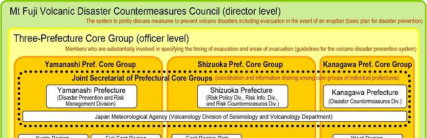
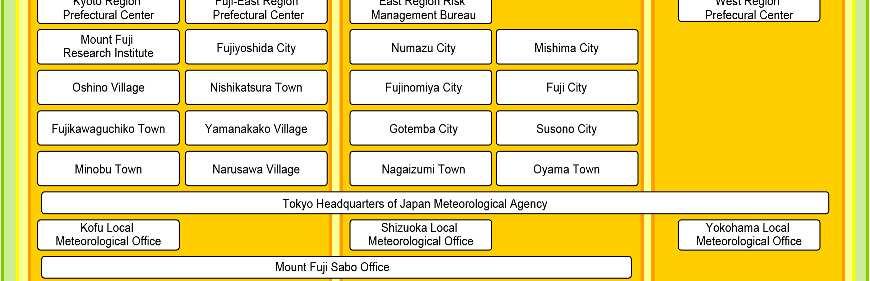
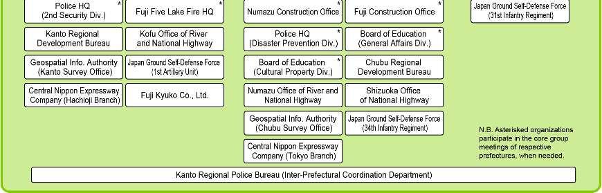
6 Reference Information 1: Volcanic Disaster Countermeasures for Fujisan Reference Information 1: Volcanic Disaster Countermeasures for Fujisan Summary The Fujisan Volcanic Disaster Management Council, consisting of the national government, Yamanashi Prefecture, Shizuoka Prefecture, Kanagawa Prefecture, other municipal governments, volcano experts, and relevant organizations, was set up in June 2012 in order to discuss comprehensive evacuation measures in case of the eruption of Fujisan and other matters jointly. It promotes the establishment of a disaster prevention system for volcanic disasters and contributes to raising awareness of local people etc. for disaster prevention. Within the Council, prefectural core groups, three-prefecture core group, and prefectural joint secretariat are established (see the figure on next page). At the prefectural core groups, matters to be discussed at each prefecture are considered by member departments and organizations. At the three-prefecture core group, all the core groups of the three prefectures gather together when needed for confirmation or coordination about overarching policies. At the joint secretariat of the prefectural core groups, the secretariats of individual prefectures put together the results of discussions at the individual groups and make necessary coordination. In case that the volcanic activities of Fujisan become active, residents and other people in wide areas need to be evacuated. Therefore, the Council has a role to play in taking measures to address volcanic disasters over a wide area, by ensuring the coordination and information sharing among member organizations and building consensus and making necessary coordination about disaster prevention measures, including wide-area evacuation, in light of the opinions of volcano experts etc. in preparation of the implementation of countermeasures that cover a wide area. 86

7 Reference Information 1: Volcanic Disaster Countermeasures for Fujisan 87
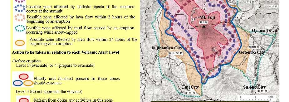
8 Reference Information 1: Volcanic Disaster Countermeasures for Fujisan Actions already implemented The Wide-area Evacuation Plan for the Eruption of Mt. Fuji provides evacuation plans consisting of specific information, such as who needs to be evacuated when from where to where, based on different types of volcanic phenomenon. Basically, in case of lava flow (generation of crater, pyroclastic flow, large volcanic ejecta, and lava flow), people are evacuated over a wide area to outside the Danger Area (area to be evacuated from); in case of snow melt triggered by volcanic eruption, ash fall, and small volcanic ejecta, people are evacuated to nearby (in robust buildings etc.). Period of evacuation and concept of to where the residents would evacuate are described below. "Climbing restriction" is issued to tourists and climbers when the announcement of "preparation for evacuation" is issued to the general public in the same area. Also, in order to prevent society from being thrown into confusion or panic due to evacuation and to avoid traffic congestions, the area to be evacuated from is delineated to the minimum necessary and the differentiated timing of evacuation is planned according to the specific conditions of locations. As a measure to ensure the public awareness of the volcanic alert levels for Fujisan and evacuation plans for different volcanic phenomena, pamphlets have been published and distributed. In October 2014, Three-Prefecture Joint Disaster Prevention Drill 2014 was conducted in order to verify and improve the effectiveness of the "Wide-area Evacuation Plan for the Eruption of Fujisan", based on three main training pillars: joint on-map training, residents evacuation training, and individual trainings of relevant organizations. In March 2015, the existing Wide-area Evacuation Plan for the Eruption of Mt. Fuji was revised, following the three points: (i) the organizational structures of the Council, the national government, Yamanashi Prefecture, Shizuoka Prefecture, and relevant municipal governments; (ii) procedures for mutual information sharing, designation of wide-area evacuation routes, principles and procedures of evacuee acceptance; and (iii) actions to be taken by different organizations to ensure the smooth wide-area evacuation according to different eruption alert levels. Future actions The Fujisan Volcanic Disaster Management Council will continue to conduct evacuation drills to verify and improve the effectiveness of the existing Wide-are Evacuation Plan for the Eruption of Mt. Fuji. In particular, the Council will have joint discussion, as appropriate, about the content of Mt. Fuji Hazard Map, the standards for robust buildings and their designation, the removal of objects obstructing wide-area evacuation routes, and the safety measures for tourists and climbers in case of sudden eruption, and will reflect the results of discussion in the Wide-area Evacuation Plan for the Eruption of Mt. Fuji. 88


9 Reference Information 1: Volcanic Disaster Countermeasures for Fujisan 89


10 Reference Information 2: Volcano Disaster Management for Visitors Summary In preparation of sudden eruption of Fujisan, a map showing the evacuation routes on the existing roads is developed and measures are taken to raise the awareness of climbers, other visitors, and other people about evacuation routes, in order to help them take actions for evacuation in case of eruption. Actions already implemented Yamanashi Prefecture surveyed the current conditions of the existing roads and, based on the records of past eruptions of Fujisan, simulated four representative patterns of eruption through exchange of opinions with experts in volcanoes, municipal governments, local stakeholders, etc., estimating the area to be affected by volcanic phenomena and developing a map showing the evacuation routes on the existing roads. The prepared map has been posted on the web site of Yamanashi Prefecture and distributed to climbers, other visitors, and other people at the facilities of the 5 th station and other places in an effort to raise awareness of the evacuation routes. Also, Shizuoka Prefecture is making a map of evacuation routes on the model of Yamanashi Prefecture s evacuation route map for the eruption of Mt. Fuji, so that they can complete the map by March Reference Information 2: Volcano Disaster Management for Visitors Future actions The issues that have been identified in the process of the survey on the current conditions of the existing roads for the development of the map and also in the process of the discussion on evacuation routes will be sorted out and translated into the future evacuation measures in case of eruption. Evacuation Route Map for the Eruption of Mt. Fuji 90


11 Reference Information 3: Development of Erosion Control Facilities at the Foot of Fujisan, Including Sabo Works for the Osawa Kuzure Summary The Ministry of Land, Infrastructure, Transport and Tourism is taking the initiative in implementing river-bed works to prevent erosion and hillside landslides at the head of the Osawa River, where land collapses have been continuing on the western slope of Fujisan (known as Osawa Kuzure). In relation to this, at the Osawa River and other steams with high risks of debris flows at the foot of Fujisan on the side of Shizuoka Prefecture, measures to prevent landslide and debris flows from flowing out to the downstream are implemented, including the installation of erosion control dams and sand retention areas at proper locations in order to prevent damage caused by debris flows. Actions already implemented The Ministry of Land, Infrastructure, Transport and Tourism has been constructing sediment-related disaster prevention facilities to prevent bank erosion, to stabilize unstable soil, and to prevent the spread of debris flows in the downstream valleys where erosion and collapses are taking place, including Osawa Kuzure, as a measure to protect the downstream areas from damage of debris flow. In addition, measures to prevent sediment-related disasters have been implemented at the streams to the southwest of Fujisan. Consolidation works at Osawa Kuzure Before After Sediment-related disaster prevention measures to the southwest of Fujisan Sand retention works Channel works Sabo dam Future actions In order to protect the downstream areas from sediment-related disasters,mount Fuji Sabo Office of the Ministry of Land, Infrastructure, Transport and Tourism will continue to construct dams for erosion and sediment control (Sabo dams) and sand retention works at Osawa Kuzure and steams to the southwest of Fujisan, and Shizuoka Prefecture will at other streams. Reference Information 3: Development of Erosion Control Facilities at the Foot of Fujisan, Including Sabo Works for the Osawa Kuzure 91
12 Reference Information 4: Prevention of the Spread of Fire during Prescribed Burning Summary Prescribed burning is a traditional process of burning dead grasses such as the miscanthus intentionally and is locally called hiire in local communities around Fujisan. Prescribed burning has been conducted for various reasons: acceleration of the growth of medicinal herbs and the miscanthus that is gathered by local people as roofing materials for traditional Japanese houses, maintenance of biodiversity, continuation of cultural traditions with the participation of local residents, and contribution to maintaining the landscapes of Fujisan, such as forests and grass fields. Reference Information 4: Prevention of the Spread of Fire during Prescribed Burning Actions already implemented Municipalities where prescribed burning is implemented have set ordinances to regulate the process of open burning. Ordinances are stipulating regulations to prevent the fire from spreading, such as suspension of the prescribed burning process when measured wind velocity exceeds the threshold value or humidity decreases below the threshold value, as well as the implementation structure of prescribed burning such as the allocation and roles of people participating in the process, and installation of fire safety zones. Safety manuals describing cautions to ensure the safety of prescribed burning are also prepared and distributed to increase the awareness of participants. Municipalities near the site of prescribed burning are also implementing safety measures such as installing fire safety zones with sufficient widths to prevent the fire from spreading to nearby forests and grass fields. Future actions The safety of people engaging in prescribed burning will continue to be ensured, based on work guidelines and safety manuals, and efforts are to be made to prevent the spread of fire. 92
13 Reference Information 5: Volcano Disaster Countermeasures for Visitors Summary Mt. Fuji Volcano Guide Map has been prepared, providing climbers and tourists visiting the northern foot of Fujisan with information of procedures for smooth evacuation in case of emergency. Mt. Fuji Volcano Guide Map has been made available at roadside stations and tourist spots for higher public awareness. Actions already implemented Mt. Fuji Volcano Guide Map has been published in Japanese, English, Chinese, and Korean in an effort to raise awareness of volcanic disaster prevention and evacuation procedures in case of eruption and has been made available at about 25 locations centering on roadside stations and tourist spots. So far, about 100 thousand copies have been distributed. Future actions Mt. Fuji Volcano Guide Map will continue to be distributed to climbers and tourists from other countries who do not have access to information about disaster prevention in advance and the information provision will be strengthened. Mt. Fuji Volcano Guide Map Reference Information 5: Volcano Disaster Countermeasures for Visitors 93
14 Reference Information 6: Disaster Controls at the Component Parts Located at the Foot of Fujisan Reference Information 6: Disaster Controls at the Component Parts Located at the Foot of Fujisan Summary With regard to the wooden buildings etc. associated with the World Heritage, Fujisan, designated by the national government, Yamanashi Prefecture, and Shizuoka Prefecture, measures have been taken based on the Disaster Prevention Business Plan by the Agency for Cultural Affairs and the Disaster Prevention Manual for Cultural Properties by Shizuoka Prefecture, such as fire prevention, recovery in case of damage due to disasters, and safety and security of lives of visitors at facilities. Efforts will be continued to call on owners of wooden buildings to maintain and manage fire prevention facilities in order to prevent fire. Also, in order to rescue cultural properties in case of a disaster, Shizuoka Prefecture has organized a network to support the rescue of cultural properties, consisting of organizations related to cultural properties within and outside Shizuoka Prefecture (hereinafter referred to as Rescue Network ). The secretariat of the Rescue Network organizes training courses for cultural property rescue supporters in order to train human resources who can work in the rescue and appointing those who completed these training courses and people with necessary skills to protect cultural properties as "cultural property rescue supporters". Actions already implemented With regard to fires at buildings such as Shinto shrines, owners or local governments which are designated as custodial bodies under the Law for the Protection of Cultural Properties are implementing measures such as the installation of fire prevention facilities including automatic fire alarm systems and the establishment of fire brigades. For the maintenance and management of these fire prevention facilities, financial assistance has been provided to owners and custodial bodies since before the inscription of Fujisan on the World Heritage List. Shizuoka Prefecture launched the rescue network in 2011 and training courses for cultural properties rescue supporters have been organized since In the Shizuoka Prefecture General Disaster Prevention Drill in 2013, cultural properties rescue supporters and the rescue network conducted a drill for information collection about damage to cultural properties and in 2014 the member organizations of the rescue network conducted the drill. Also the municipalities of Yamanashi Prefecture in coordination with Yamanashi Prefecture developed a manual for ensuring the safety of visitors to the relevant component parts (hereinafter referred to as manual ) in Future actions Financial assistance will continue to be provided for maintenance and management of fire prevention facilities. Also, training courses for cultural properties rescue supporters will be continued and the efforts to enhance the rescue network will also be continued. Municipal governments within Yamanashi Prefecture will conduct disaster prevention drills in accordance with the manual, while verifying and revising the manual. 94
Volcano Disaster Prevention Work of the Cabinet Office
 Volcano Disaster Prevention Work of the Cabinet Office Hideaki FUJIYAMA *, Shinichi TOKUMOTO *, Kiyotaka KOCHI *, and Toshiki SHIMBARU * 1. Introduction Our country, the volcanic islands of which are among
Final Presentation on Disaster Risk Management in Japan. Through ADRC V. R Programme. Main Findings and Action Plan:
 Final Presentation on Disaster Risk Management in Japan Through ADRC V. R Programme Main Findings and Action Plan: Problem/Hazard and Disaster in Japan Good Practiced on Disaster Risk Management in Japan
Sustainable Disaster Prevention Measures around the Kirishima Volcano
 Disaster Mitigation of Debris Flows, Slope Failures and Landslides 687 Sustainable Disaster Prevention Measures around the Kirishima Volcano Takeshi Honda, Kazuo Yamanaka, Hirokazu Iita, Munehiro Matsui,
KNOWLEDGE NOTE 5-1. Risk Assessment and Hazard Mapping. CLUSTER 5: Hazard and Risk Information and Decision Making. Public Disclosure Authorized
 Public Disclosure Authorized Public Disclosure Authorized Public Disclosure Authorized Public Disclosure Authorized KNOWLEDGE NOTE 5-1 CLUSTER 5: Hazard and Risk Information and Decision Making Risk Assessment
NGIAs' roles in successful disaster response
 The Second UN-GGIM-AP Plenary Meeting NGIAs' roles in successful disaster response Japan Teheran Iran 28 October 2013 Shin-ichi SAKABE, Director of International Affairs Division Geospatial Information
Hazard Resilience Index (HRI) Earthquakes, Tsunamis, and Volcanoes
 Earthquakes, Tsunamis, and Volcanoes") Hazard Index (HRI) Earthquakes, Tsunamis, and Volcanoes Earthquakes Tsunamis Volcano-Ash Falls, Projectiles and Lateral Blasts, Pyroclastic Flows and Lava Flows Earthquakes, Tsunamis and Volcanoes Please
Hazard Index (HRI) Earthquakes, Tsunamis, and Volcanoes Earthquakes Tsunamis Volcano-Ash Falls, Projectiles and Lateral Blasts, Pyroclastic Flows and Lava Flows Earthquakes, Tsunamis and Volcanoes Please
GENERAL. CHAPTER 1 BACKGROUND AND PURPOSE OF THE GUIDELINES Background of the Guidelines Purpose of the Guidelines...
 GENERAL CHAPTER 1 BACKGROUND AND PURPOSE OF THE GUIDELINES... 1 1.1 Background of the Guidelines... 1 1.2 Purpose of the Guidelines... 3 CHAPTER 2 APPLICATION OF THE GUIDELINES... 3 2.1 Potential Users
GUIDELINES FOR CONSTRUCTION TECHNOLOGY TRANSFER DEVELOPMENT OF WARNING AND EVACUATION SYSTEM AGAINST SEDIMENT DISASTERS IN DEVELOPING COUNTRIES
 GUIDELINES FOR CONSTRUCTION TECHNOLOGY TRANSFER DEVELOPMENT OF WARNING AND EVACUATION SYSTEM AGAINST SEDIMENT DISASTERS IN DEVELOPING COUNTRIES MARCH 2004 Ministry of Land, Infrastructure and Transport
Preparing for Eruptions What will happen in future eruptions and how can we be prepared?
 Lesson Plan 12 Activities 1. Read or listen to Matt s Volcano Story from What s the Plan Stan Stories on: http://www.whatstheplanstan.govt.nz/teacher.html#disasters Discuss what Matt saw and did before,
Also, when Cascade volcanoes do erupt, high-speed avalanches of pyroclastic flows
 INTRODUCTION A volcano is a vent through which molten rock escapes to the Earth s surface. Unlike other mountains, which are pushed up from below, volcanoes are built by surface accumulation of their eruptive
Born in Unzen The World s First Unmanned Construction of Multilayer Sediment Control Dam Using Sediment Forms Unzen Restoration Project Office
 Born in Unzen The World s First Unmanned Construction of Multilayer Sediment Control Dam Using Sediment Forms Unzen Restoration Project Office Unzen Restoration Project Office Kyushu Regional Construction
Volcanoes. Introduction
 Volcanoes Introduction Display Slide V-0 Explain that a volcano is a vent through which molten rock escapes to the Earth s surface. Unlike other mountains, which are pushed up from below, volcanoes are
SEISMIC RISK ASSESSMENT IN ARMENIA
 SEISMIC RISK ASSESSMENT IN ARMENIA Hovhannes Khangeldyan Head of National Crisis Management Center Rescue Service Ministry of Emergency Situations of the Republic of Armenia Tokyo, 2016 ARMENIA: GEOGRAPHICAL
In Issue of International Sabo News Letter
 In Issue of International Sabo News Letter I had an opportunity to make a keynote speech on March 18 2003 at the session on Sedimentrelated Issues at the 3rd World Water Forum held in (Kyoto) Japan. Chairing
Assessing Hazards and Risk
 Page 1 of 6 EENS 204 Tulane University Natural Disasters Prof. Stephen A. Nelson Assessing Hazards and Risk This page last updated on 07-Jan-2004 As discussed before, natural disasters are produced by
Outline of Guideline for Development and Utilization of Tsunami Disaster Management Map
 Outline of Guideline for Development and Utilization of Tsunami Disaster Management Map Port and Airport Research Institute, Japan The Overseas Coastal Area Development Institute of Japan Ports and Harbours
Interpretive Map Series 24
 Oregon Department of Geology and Mineral Industries Interpretive Map Series 24 Geologic Hazards, and Hazard Maps, and Future Damage Estimates for Six Counties in the Mid/Southern Willamette Valley Including
Progress Report. Flood Hazard Mapping in Thailand
 Progress Report Flood Hazard Mapping in Thailand Prepared By: Mr. PAITOON NAKTAE Chief of Safety Standard sub-beuro Disaster Prevention beuro Department of Disaster Prevention and Mitigation THAILAND E-mail:
4-3-1 Earthquake and Tsunami Countermeasures of Tokyo s
 4-3-1 Earthquake and Tsunami Countermeasures of Tokyo s Sewerage Masahiro Hikino* and Gaku Sato** *Planning Section, Planning and Coordinating Division, Bureau of Sewerage, Tokyo Metropolitan Government
Risk-based land use and spatial planning
 Risk-based land use and spatial planning Miho OHARA International Centre for Water Hazards and Risk Management (ICHARM) Public Works Research Institute PWRI), Japan Under the auspices of UNESCO Introduction
Geography Education Challenges Regarding Disaster Mitigation in Japan
 Geography Education Challenges Regarding Disaster Mitigation in Japan Koji OHNISHI 1 University of Toyama, Toyama, JAPAN Hiroshi MITSUHASHI 2 Ministry of Education, Culture, Sports, Science & Technology,
Flood Management in Japan
 Flood Management in Japan 1. Comprehensive Flood Control Measures 2. Provision of River information 3. Responses to the Niigata Torrential Rain Disaster 4. About ICHARM 5. Responses to 2011 Thailand Floods
Landslide Disaster Management in Sri Lanka and Nichola Oya as a Case study. Group 16 Gamini Jayathissa Udeni Nawagamuwa
 Landslide Disaster Management in Sri Lanka and Nichola Oya as a Case study Group 16 Gamini Jayathissa Udeni Nawagamuwa Taiwan Sri lanka >2582 mm, max >5000mm NE= Nov. to Feb 1750 2500 mm >2500 mm Central
Rebuilding Flood-Conscious Society
 A zone where strong flood flow or river bank erosion by levee breach are anticipated, which likely to occur collapsing/washing away of house. Set up the joint councils by relative stakeholders(river managers,
Safety Procedures for Volcanic Activity in the United States and Japan
 Parkland College A with Honors Projects Honors Program 2015 Safety Procedures for Volcanic Activity in the United States and Japan Ashley Eisenmenger Parkland College Recommended Citation Eisenmenger,
DIPLOMA IN DISASTER MANAGEMENT. (Non-Semester) (With effect from the academic year )
 (With effect from the academic year )") DIPLOMA IN DISASTER MANAGEMENT (Non-Semester) (With effect from the academic year 2013-14) Eligibility for the Course Candidate should have passed the Higher Secondary Examination conducted by the Board
DIPLOMA IN DISASTER MANAGEMENT (Non-Semester) (With effect from the academic year 2013-14) Eligibility for the Course Candidate should have passed the Higher Secondary Examination conducted by the Board
Outline and Future Strategies of SABO Works in Japan. Koji Nishiyama
 Outline and Future Strategies of SABO Works in Japan Koji Nishiyama Director General Sabo Department, Ministry of Land, Infrastructure, Transport and Tourism -MLIT Japan Jun. 15th, 2017 The 10 th Japan-Italy
What Are Disasters? The Rescue Kids Trio!
 The Rescue Kids Trio! What Are Disasters? This manual was made possible through funding by the Council of Local Authorities for International Relations. Disasters and emergency preparedness Emergency preparedness
CHALLENGES ON SEDIMENT- RELATED DISASTER MITIGATION
 CHALLENGES ON SEDIMENT- RELATED DISASTER MITIGATION Dolores M. Hipolito Project Manager II DPWH, PMO-FCSEC Types of Sediment-Related Disasters A. Direct Disaster Debris flows Landslides Slope failures
Disaster RISK Management : Bhutanese Scenario
 Disaster RISK Management : Bhutanese Scenario Expert Group Meeting (EGM) on Geo-referenced Information Systems for Disaster Risk Management (Geo-DRM) and sustaining the Community of Practice (COP), Bangkok,
They include earthquakes, volcanic eruptions, floods, landslides, and other processes and occurrences. They are included in the broader concept of.
 They include earthquakes, volcanic eruptions, floods, landslides, and other processes and occurrences. They are included in the broader concept of. In general, natural processes are labeled hazardous only
Emergency Sabo Works for Volcanic Disaster Reduction in Japan - Mt. Asamayama: A Case Study -
 Emergency Sabo Works for Volcanic Disaster Reduction in Japan - Mt. Asamayama: A Case Study - KANNO Tadahiro 1 *, ANDO Shohei 2, HASHINOKI Toshihiro 3 1 Tonegawa River System Sabo Office, MLIT (121-1 Shibukawa,
DEBRIS FLOW DISASTER MITIGATION THROUGH COMMUNITY-BASED INTEGRATED SEDIMENT MANAGEMENT (BEST PRACTICE IN MT. MERAPI AREA, INDONESIA)
") Civil Engineering Forum Volume XXI/3 - September 2012 DEBRIS FLOW DISASTER MITIGATION THROUGH COMMUNITY-BASED INTEGRATED SEDIMENT MANAGEMENT (BEST PRACTICE IN MT. MERAPI AREA, INDONESIA) K. Otani Yachiyo
Civil Engineering Forum Volume XXI/3 - September 2012 DEBRIS FLOW DISASTER MITIGATION THROUGH COMMUNITY-BASED INTEGRATED SEDIMENT MANAGEMENT (BEST PRACTICE IN MT. MERAPI AREA, INDONESIA) K. Otani Yachiyo
The Application of Sabo Technology for Lahars Flood Mitigation and Warning System in Volcanic Area. Agus Sumaryono Bambang Sukatja F.
 The Application of Sabo Technology for Lahars Flood Mitigation and Warning System in Volcanic Area Agus Sumaryono Bambang Sukatja F. Tata Yunita BACKGROUND The Indonesia Government has constructed several
Natural hazards in Glenorchy Summary Report May 2010
 Natural hazards in Glenorchy Summary Report May 2010 Contents Glenorchy s hazardscape Environment setting Flood hazard Earthquakes and seismic hazards Hazards Mass movement Summary Glossary Introduction
UNESCO World Heritage Centre - Arab States Unit
 UNESCO World Heritage Centre - Arab States Unit Post-Conflict Reconstruction in the Middle East Context and in the Old City of Aleppo in Particular UNESCO Headquarter, 18-19 June 2015 ACTION PLAN resulting
Practical Example of the Use of a Volcano Hazard Map in 2000 Eruption of the Usu Volcano
 Practical Example of the Use of a Volcano Hazard Map in 2000 Eruption of the Usu Volcano Efforts by the town of Sobetsu for coexistence with ever-changing Earth Toshiya TANABE * 1. Introduction On March
Sediment Disasters and Mass Movement (SD&M 2 ) NATIONAL DISASTER MANAGEMENT RESEARCH INSTITUTE
 NATIONAL DISASTER MANAGEMENT RESEARCH INSTITUTE") Sediment Disasters and Mass Movement (SD&M 2 ) Contents Outline of SD&M 2 Major outcomes Issues and conclusions Prologue Mass movement in Ulsan, Korea by Typhoon CHABA on Oct. 5. Outline of SD&M 2 Activities
Sediment Disasters and Mass Movement (SD&M 2 ) Contents Outline of SD&M 2 Major outcomes Issues and conclusions Prologue Mass movement in Ulsan, Korea by Typhoon CHABA on Oct. 5. Outline of SD&M 2 Activities
Hurricane Preparation and Recovery. October 11, 2011 Jon Nance, Chief Engineer, NCDOT
 Hurricane Preparation and Recovery October 11, 2011 Jon Nance, Chief Engineer, NCDOT North Carolina & Severe Weather Our state often bears the brunt of storms, which include: Ice storms Snow storms Heavy
COMMUNITY EMERGENCY RESPONSE TEAM
 COMMUNITY EMERGENCY RESPONSE TEAM INSTRUCTOR GUIDE 40 hour curriculum DEVELOPED FOR: FEDERAL EMERGENCY MANAGEMENT AGENCY EMERGENCY MANAGEMENT INSTITUTE UNITED STATES FIRE ADMINISTRATION DEVELOPED BY: HUMAN
Mitigation planning in Epirus- The case of frost and snowfalls. Thematic seminar Epirus September 2011
 Mitigation planning in Epirus- The case of frost and snowfalls Thematic seminar Epirus September 2011 1 Structure of Mitigation Planning in Greece First Level: General Plan for Civil Protection Ksenokratis
Chapter 5 THE DEVELOPMENT OF VOLCANIC EMERGENCY PLANS. 5.1 Introduction
 Chapter 5 THE DEVELOPMENT OF VOLCANIC EMERGENCY PLANS 5.1 Introduction It will be assumed in this chapter: (0) That in any community exposed to volcanic hazards there is general awareness of the hazard
Fukien Secondary School Monthly Vocabulary/Expression List for EMI Subjects Secondary Two. Subject: Geography
 Focus: General Specific : Section Two : Unit One 1 Landslide 2 Downslope movement 3 Rock 4 Soil 5 Gravity 6 Natural hazard 7 Rainwater 8 Friction 9 Hilly relief 10 Unstable 11 Season 12 Saturated 13 Construction
Jeopardy. Final Jeopardy $100 $100 $100 $100 $100 $200 $200 $200 $200 $200 $300 $300 $300 $300 $400 $400 $400 $500 $500 $500 $500 $500
 Jeopardy Earthquakes Volcanoes Tsunamis Wildfires Landslides/ Droughts $100 $100 $100 $100 $100 $200 $200 $200 $200 $200 $300 $300 $300 $300 $300 $400 $400 $400 $400 $400 $500 $500 $500 $500 $500 Final
EVALUATION ON THE IMPLEMENTATION OF EARLY WARNING SYSTEM FOR DEBRIS FLOW IN MERAPI AREA (CASE STUDY AT BOYONG RIVER)
") Journal of the Civil Engineering Forum Vol. 1 No. 3 (September 2015) EVALUATION ON THE IMPLEMENTATION OF EARLY WARNING SYSTEM FOR DEBRIS FLOW IN MERAPI AREA (CASE STUDY AT BOYONG RIVER) Ali Cahyadi Achmad
Journal of the Civil Engineering Forum Vol. 1 No. 3 (September 2015) EVALUATION ON THE IMPLEMENTATION OF EARLY WARNING SYSTEM FOR DEBRIS FLOW IN MERAPI AREA (CASE STUDY AT BOYONG RIVER) Ali Cahyadi Achmad
GOAL 7 AREAS SUBJECT TO NATURAL DISASTERS AND HAZARDS. To protect life and property from natural disasters and hazards.
 GOAL 7 AREAS SUBJECT TO NATURAL DISASTERS AND HAZARDS A. GOALS: To protect life and property from natural disasters and hazards. B. POLICIES: 1. Floodplains shall be maintained as natural drainage-ways.
Lessons learnt from 2014 Mt Ontake and 2000 Mt Usu eruptions: findings from a post-eruption ballistic impact assessment trip to Japan
 Lessons learnt from 2014 Mt Ontake and 2000 Mt Usu eruptions: findings from a post-eruption ballistic impact assessment trip to Japan Rebecca Fitzgerald, Ben Kennedy, Thomas Wilson, Graham Leonard, Kae
LOCATIONS OF SELECTED MITIGATION SITES IN JAPAN
 LOCATIOS OF SELECTED MITIGATIO SITES I JAPA Hyogo prefecture near Kobe, Japan Hyogo province Gifu province Osaka Kobe Gifu prefecture near Takayama, Japan akao Kamikochi ational Park Mount Yake Tateyama
RELATIONSHIP BETWEEN AGE OF GROUND AND LIQUEFACTION OCCURRENCE IN THE 2011 GREAT EAST JAPAN EARTHQUAKE
 Proceedings of the International Symposium on Engineering Lessons Learned from the 2011 Great East Japan Earthquake, March 1-4, 2012, Tokyo, Japan RELATIONSHIP BETWEEN AGE OF GROUND AND LIQUEFACTION OCCURRENCE
Volcanoes: Help or Hindrance?
 Volcanoes: Help or Hindrance? Volcanic eruptions can range from violent to mild. All kinds of eruptions have effects that can be both harmful and beneficial to people and the environment. Volcanoes Can
Wildfire Preparedness
 Wildfire Preparedness Wildfires are common disasters that can spread quickly, especially during dry conditions. More than 100,000 wildfires clear 4-5 million acres of land in the US every year. Wildfires
City of Punta Gorda Community Emergency Management Plan 2013
 City of Punta Gorda Community Emergency Management Plan 2013 Hurricane Andrew- August 24, 1992 Category 5 hurricane. The second-most-destructive hurricane in U.S. history. The first named storm of the
Using Operating Experience to Prevent or Mitigate Nuclear Events. What Is, Was and Will Be Available
 Using Operating Experience to Prevent or Mitigate Nuclear Events What Is, Was and Will Be Available Introduction Remember, it is by understanding the lessons learned from past events that we can adequately
The Third UN-GGIM-AP Plenary Meeting. Use of Geospatial Information in Disaster and Coordination among NDMA and Relevant Organizations/Stakeholders
 The Third UN-GGIM-AP Plenary Meeting Use of Geospatial Information in Disaster and Coordination among NDMA and Relevant Organizations/Stakeholders Bali Indonesia 10 November 2014 Bernardus Wisnu Widjaja
3l NATURAL HAZARDS AND UNSTABLE GROUND
 Page 1 of Section 3l 3l NATURAL HAZARDS AND UNSTABLE GROUND 3l.1 Introduction A natural hazard is the result of natural processes that form, shape and change the environment and interact or potentially
Hurricane Readiness for Coastal Communities
 Hurricane Readiness for Participant Guide Developed for: Federal Emergency Management Agency Emergency Management Institute 16825 South Seton Avenue Emmitsburg, MD 21727-8998 Developed by: C² Technologies,
The 26 th Session of the International Coordination Council of the Man and the Biosphere (MAB) Programme (10-13 June 2014 UNESCO) NATIONAL REPORT
 Programme (10-13 June 2014 UNESCO) NATIONAL REPORT") The 26 th Session of the International Coordination Council of the Man and the Biosphere (MAB) Programme (10-13 June 2014 UNESCO) NATIONAL REPORT Republic of Korea Following the 25 th session of MAB-ICC,
The 26 th Session of the International Coordination Council of the Man and the Biosphere (MAB) Programme (10-13 June 2014 UNESCO) NATIONAL REPORT Republic of Korea Following the 25 th session of MAB-ICC,
Application for Geotourism Charter
 Application for Geotourism Charter Thank you for the interest in geotourism as a long-term strategy to foster wisely managed tourism and enlightened destination stewardship. National Geographic s Center
Declaration Population and culture
 Declaration Population and culture The ministers of the parties to the Alpine Convention regard the socio-economic and socio-cultural aspects mentioned in Article 2, Paragraph 2, Item a., as being central
Oregon APA Legal Issues Workshop December 7, Tricia Sears, DLCD With information from Bill Burns, DOGAMI
 Oregon APA Legal Issues Workshop December 7, 2018 Tricia Sears, DLCD With information from Bill Burns, DOGAMI How this Topic Arrived WE FREQUENTLY HEAR CONCERNS ABOUT LIABILITY AND TAKINGS. Current federal
ACADEMIC YEAR SOCIAL STUDIES YR 9 CONCEPT REVIEW NOTES UNIT 2 : EARTHQUAKES & VOLCANOES What are volcanoes and earthquakes like?
 ACADEMIC YEAR 2016-2017 SOCIAL STUDIES YR 9 CONCEPT REVIEW NOTES UNIT 2 : EARTHQUAKES & VOLCANOES What are volcanoes and earthquakes like? Pages 26-27 1) What are you going to learn about in this unit?
Beyond the Book. FOCUS Book
 FOCUS Book Suppose your city wants to build a new housing development on a steep slope outside town. Design a model to test whether the land is safe from the types of landslides you read about in this
GIS present situation in Japan
 GIS present situation in Japan September 26, 2006 INTERPREVENT 2006 in Niigata University Geographic Information Analysis Research Div. Geography and Crustal Dynamics Research Senter Geographical Survey
Natural Disaster :.JP s Experience and Preparation
 Natural Disaster :.JP s Experience and Preparation 14 March. 2018 Hiro Hotta 1 Where s Japan Japan Puerto Rico earthquakes large enough to feel : 2,000-20,000 times a year typhoons disastrous
Internationales Symposion INTERPRAEVENT 2004 RIVA / TRIENT
 APPLICATION TO PAST DISASTERS OF A METHOD OF SETTING APPLICATION THE RANGE TO OF PAST DEBRIS DISASTERS FLOW OF DAMAGE A METHOD TO HOUSES OF SETTING THE RANGE OF DEBRIS FLOW DAMAGE TO HOUSES Hideaki Mizuno
Safety Issue: Types of weather emergencies and natural. Weather Emergencies
 Overview Safety Issue: Rapid and effective response to weather emergencies and other natural disasters whether during or after work hours takes forethought and careful planning. Types of weather emergencies
Tornadoes Module 2. - Tornado Watch -
 1 2 - Tornado Watch - Issued by the National Weather Service when tornadoes are possible in an area Remain alert for approaching storms Remind family/employees of location of safest places Listen to the
ENSURE. Coordinator: Hormoz MODARESSI Website:
 ENSURE Coordinator: Hormoz MODARESSI h.modaressi@brgm.fr Website: http://ensureproject.eu/ The project is financed by the European Commission under the 7th Framework Programme for Research and Technological
Emergency Preparedness Questions
 Emergency Preparedness Questions 1. A family emergency plan should NOT include which of the following? a) Information about your children's school(s) b) The name and phone number of an out-of-town contact
Prevention Tsunami wall 10m high (breached by the tsunami due to land level falling by 3m)
") Plate margin Plates Causes Sendai, Japan Convergent plate margin Pacific and Eurasian Plates Convergent plate margin Sima (Pacific plate) moves towards the sial (Eurasian plate) Sima (Pacific plate) is
Plate margin Plates Causes Sendai, Japan Convergent plate margin Pacific and Eurasian Plates Convergent plate margin Sima (Pacific plate) moves towards the sial (Eurasian plate) Sima (Pacific plate) is
LANDSCAPES LANDSCAPES HUMAN IMPACT. PART II: People and their 4/10/2018. GEOG 101 Part II People and their Physical Environment R E M I N D E R S
 R E M I N D E R S Get study guide from course home page. TEXTBOOK READING FOR EXAM II WEATHER and CLIMATE: Ch. 2 LITHOSPHERE: chapter 3 BIOSPHERE: chapter 4 EARTH RESOURCES: chapter 5 Two required essays
DISATER MANAGEMENT IN LIBRARIES
 DISATER MANAGEMENT IN LIBRARIES by S. Padmashree National Seminar cum Workshop on Trends & Challenges in LIS Education and Profession March 24 25 th 2017 Andhra University, Visakhapatnam Disaster - A
Floods 2014 a wake up call to natural hazards
 Floods 2014 a wake up call to natural hazards Floods affected 119 municipalities (out of 165) 22% of total population affected by floods More than 30 municipalities sustained extensive damage 57 lives
Lesson 8. Natural Disasters
 Lesson 8 Natural Disasters 1 Reading is NOT a spectator sport! 2 Reading requires active participation! 3 PREDICT Try to figure out what information will come next and how the selection might end. 4 Natural
Mass Wasting: The Work of Gravity
 Chapter 15 Lecture Earth: An Introduction to Physical Geology Twelfth Edition Mass Wasting: The Work of Gravity Tarbuck and Lutgens Chapter 15 Mass Wasting The Importance of Mass Wasting Slopes are the
Overview of Early Warning Systems and the role of National Meteorological and Hydrological Services
 Overview of Early Warning Systems and the role of National Meteorological and Hydrological Services South Africa Second Experts Symposium on Multi-Hazard Early Warning Systems With focus on the Role of
Geologic Management. Contents
 Geologic Management Contents Introduction... GM-3 Definitions... GM-3 Legislation and Other Guidance... GM-3 Policy Management for Representation... GM-5... GM-5 Inventory of Significant Geologic Features
HISTORY OF HEAVY RAINFALL DISASTER INFORMATION IN JAPAN
 transmission, for a state-of-the-art review. In addition, issues expected to arise in the future are discussed. HISTORY OF HEAVY RAINFALL DISASTER INFORMATION IN JAPAN Progress of Rainfall Observation
Responders Organized for Pass Emergencies (ROPE)
") Responders Organized for Pass Emergencies (ROPE) Miles H. Wagner Emergency Services Officer San Bernardino County Fire Department Office of Emergency Services Mark A. Hartwig Fire Chief/Fire Warden ROPE
Responders Organized for Pass Emergencies (ROPE) Miles H. Wagner Emergency Services Officer San Bernardino County Fire Department Office of Emergency Services Mark A. Hartwig Fire Chief/Fire Warden ROPE
Copernicus Overview. Major Emergency Management Conference Athlone 2017
 Copernicus Overview Major Emergency Management Conference Athlone 2017 Copernicus is a European programme implemented by the European Commission. The services address six thematic areas: land, marine,
2014 Annual Mitigation Plan Review Meeting
 2014 Annual Mitigation Plan Review Meeting Highland County EMA MEETING OBJECTIVES Understand Your Natural Disaster Risk Review of Previous Plans Current Plan Status Future Activity Plan/Needs of Each Community
19. Esan Continuously Monitored by JMA
 19. Esan Continuously Monitored by JMA Latitude: 41 48'17" N, Longitude: 141 09'58" E, Elevation: 618 m (Esan) (Triangulation Point) Overview of Esan, taken from east side on March 13, 2009 by the Japan
- Information before strong ground motion -
 -Earthquake Early Warning - Information before strong ground motion - Mitsuyuki HOSHIBA Japan Meteorological Agency January 12, 2007 1 Distribution of Earthquakes Causing Tsunami (1896~2004) in Japan Distribution
Use of Climate information in Disaster Risk Management in Zimbabwe
 Use of Climate information in Disaster Risk Management in Zimbabwe WMO Regional Technical Meeting & User/CONOPS Workshop, 28 th October 2015 Lameck Betera Department of Civil Protection Institutional Arrangements
JICA s Experiences of Connecting Japanese Science & Technologies for Disaster Risk Reduction in Developing Countries
 JICA s Experiences of Connecting Japanese Science & Technologies for Disaster Risk Reduction in Developing Countries Junji WAKUI Deputy Director General, Group Leader Disaster Risk Reduction Group Global
Introduction to Environmental Geology, 5e Case History: Indonesian Tsunami Indonesian Tsunami (2) Introduction Historic Tsunamis
 Introduction Historic Tsunamis") 1 2 3 4 5 6 7 8 9 Introduction to Environmental Geology, 5e Chapter 7 Tsunami Case History: Indonesian Tsunami December 26, 2004, within a few hours, close to 250,000 people were killed With no warning
1 2 3 4 5 6 7 8 9 Introduction to Environmental Geology, 5e Chapter 7 Tsunami Case History: Indonesian Tsunami December 26, 2004, within a few hours, close to 250,000 people were killed With no warning
Experimental Study on Effect of Houses on Debris-Flow Flooding and Deposition in Debris Flow Fan Areas
 DATA ACQUISITION AND MODELLING (MONITORING, PROCESSES, TECHNOLOGIES, MODELS) Experimental Study on Effect of Houses on Debris-Flow Flooding and Deposition in Debris Flow Fan Areas Kana Nakatani, Dr. 1
SCIENCE. Natural Disasters ARTHUR P. SCHALICK HIGH SCHOOL CURRICULUM PITTSGROVE TOWNSHIP SCHOOL DISTRICT PITTSGROVE, NJ
 SCIENCE Natural Disasters ARTHUR P. SCHALICK HIGH SCHOOL CURRICULUM PITTSGROVE TOWNSHIP SCHOOL DISTRICT PITTSGROVE, NJ 2013 PITTSGROVE BOARD OF EDUCATION Melissa Conover Cheryl Berwick William H. Rumpp
Rapid Changes on Earth: Earthquakes, Volcanoes, Landslides. Chapter 6 Study Guide
 Rapid Changes on Earth: Earthquakes, Volcanoes, Landslides Chapter 6 Study Guide Magma is 1. The point underground where an earthquake starts. 2. Molten rock beneath the Earth s surface. 3. Molten rock
Term Knowledge Using and applying Grade Criteria Autumn 1 Assessment window October Natural hazards pose major risks to people and property.
 Assessment Schedule Year 9 2015/6 Term Knowledge Using and applying Grade Criteria Autumn 1 Assessment window October 2015 3.1.1.2 Tectonic Natural hazards pose major risks to people and property. Definition
Disaster Management in Republic of Korea
 The Third UN-GGIM-AP Plenary Meeting Disaster Management in Republic of Korea ~Coordination among NGIA & Other Related Organizations and Recommendations~ Bali Indonesia 10 November 2014 Sanghoon Lee, Ph.D.
CONFERENCE STATEMENT
 CONFERENCE STATEMENT We, the elected representatives from Canada, Denmark/Greenland, Finland, Iceland, Norway, Russia, Sweden and the United States of America; In collaboration with the indigenous peoples
Land-use planning and volcanic hazards: Opportunities for New Zealand
 Land-use planning and volcanic hazards: Opportunities for New Zealand Julia Becker, Wendy Saunders, Graham Leonard, David Johnston, Lower Hutt Clare Robertson, Massey University, Palmerston North Presentation
A Survey of Refuge and Evacuation Path on Seoul Flood Disaster Information Map
 , pp.142-146 http://dx.doi.org/10.14257/astl.2015.89.29 A Survey of Refuge and Path on Seoul Flood Disaster Information Map Ji-Eun Sun 1, Ji-Soo Lee 2, Won-Hwa Hong 3, 1 Graduate Student, Department of
WMO/WWRP FDP: INCA CE
 WMO/WWRP FDP: INCA CE Yong Wang ZAMG, Austria This project is implemented through the CENTRAL EUROPE Programme co-financed by the ERDF INCA CE: implementation over Central Europe A Nowcasting Initiative
Debris flow: categories, characteristics, hazard assessment, mitigation measures. Hariklia D. SKILODIMOU, George D. BATHRELLOS
 Debris flow: categories, characteristics, hazard assessment, mitigation measures Hariklia D. SKILODIMOU, George D. BATHRELLOS Natural hazards: physical phenomena, active in geological time capable of producing
Disaster Management and Spatial Data An Experience of Sri Lanka for Joint project team meeting 2012
 Disaster Management and Spatial Data An Experience of Sri Lanka for Joint project team meeting 2012 1 by Padma Kumara Withana Provincial Surveyor General Uva Province 2 Out line ü Introduction ü Natural
WHAT S CIVIL DEFENCE?
 WHAT S CIVIL DEFENCE? The Civil Protection Department was found in 1982 in order to prevent, forecast and supervise the natural disasters in agreement with regional and local governments. It also cooperates
New Tsunami Disaster Mitigation System considering Local Conditions of Indian Ocean Rim Regions
 New Tsunami Disaster Mitigation System considering Local Conditions of Indian Ocean Rim Regions Kimiro Meguro Professor, Institute of Industrial Science, The University of Tokyo, Japan Shunichi Koshimura
National Public Weather and Warning Services in the Swaziland Meteorological Service Dennis S.Mkhonta /
 National Public Weather and Warning Services in the Swaziland Meteorological Service Dennis S.Mkhonta dennis.mkhonta@gmail.com / dennis@swazimet.gov.sz Introduction Swaziland s geographical position exposes