Lessons learnt from 2014 Mt Ontake and 2000 Mt Usu eruptions: findings from a post-eruption ballistic impact assessment trip to Japan
|
|
|
- Thomas Hill
- 6 years ago
- Views:
Transcription


1 Lessons learnt from 2014 Mt Ontake and 2000 Mt Usu eruptions: findings from a post-eruption ballistic impact assessment trip to Japan Rebecca Fitzgerald, Ben Kennedy, Thomas Wilson, Graham Leonard, Kae Tsunematsu, George Williams rebecca.fitzgerald@pg.canterbury.ac.nz
2 VOLCANIC UNREST Forecasting large eruptions Major Eruption (Mount St. Helens, 1980;Pinatubo 1991) Decision Window when civil officials face critical decisions about public safety before the volcanic outcome is known. Time C.D. Miller, USGS
3 VOLCANIC UNREST Other possible outcomes of heightened unrest. Sudden onset, no decision window Decision Chaiten, Window 2008 MAJOR ERUPTION: MSH 1980, EVENTUAL ERUPTION: Soufriere Hills 1995 Variable unrest &/or small eruptions RETURN TO QUIET: Cotopaxi 2002 RETURN TO QUIET: Guadeloupe Time C.D. Miller, USGS


4 What are ballistics? Pieces of lava or rock ejected in an eruption on a ballistic trajectory Can travel hundreds of m/s and up to ~10 km from the vent Range from a few cm to tens of metres in diameter


5 Why do we care? Ballistics can kill, injure and severely damage buildings and infrastructure Ballistics are a potential hazard at many of New Zealand s volcanoes including Ruapehu, Tongariro and within the Auckland Volcanic Field Tricky risk management We need to better understand their potential impacts and how best to mitigate them

6 Trip Overview Ballistic impact assessment trip to Japan in July 2015 Mt Usu Life Safety Impacts to buildings Mt Ontake Collaborative project with: University of Canterbury, GNS Science, EQC, Mount Fuji Research Institute, Nagoya University and Geological Survey of Japan


7 Te Maari 2012 vs. Mt Ontake 2014 Very similar eruptions with very different consequences. Both the same eruption: style, size and types of hazards Both have popular hiking trails Te Maari eruption occurred at night in low season. Ontake occurred around midday in peak season when hundreds of people were on the mountain No injuries or fatalities at Te Maari, 58 fatalities and over 70 injuries at Ontake


8 Risk context Te Maari ~ 100,000 visitors/yr Three permanent unreinforced huts along TAC Well monitored Had 6 minutes of increasing precursory seismicity Mt Ontake ~ 1,000,000 visitors/yr 15 permanent unreinforced huts and lodges Well monitored Had 7 mins of increasing precursory seismicity and inflation
 However both Te Maari and Ontake ballistics show that they can be much")
9 Ballistic size Ballistics generally thought of as bomb/block size (> 6.4cm) However both Te Maari and Ontake ballistics show that they can be much smaller
10 Revising protection actions All hikers that hid in buildings survived Many of those sheltering around buildings unable to get inside, died. As did those in the open. Reports of survivors using hiking packs as shields successfully Both successful and unsuccessful attempts at sheltering behind large boulders.

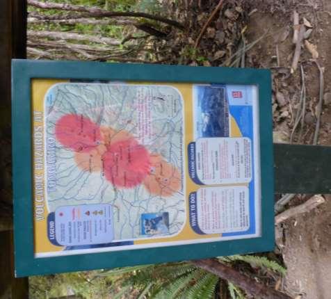
11 Hazard maps and signage

12 While in Japan, Grahem Leonard (GNS Science) had meetings with the JMA and GSJ to help improve their alert level system and posed in front of bakeries
13 NZ JAPAN Ballistic risk cooperation NZ alert levels focused on current volcano status and hazard distance forecasting given in alert bulletins. Japanese alert levels include forecasting and evacuation so reluctant to raise Volcanic research, the production of hazard maps and research around disaster impacts are not connected to JMA Working with JMA and GSJ to improve community linkage and risk management approaches NZ and JMA recently announced rapid warning via mobile phones. NZ = Auckland app, Red Cross, ERS, Google. Still won t help with unheralded eruptions.

 Level 3 (2km)")
14 Alert levels and restriction zones Level 3 (4km) Level 3 (3km) Level 3 (2km) Level 2 (1km)
15 Overview Ballistic impact assessment trip to Japan in July 2015 Mt Usu Building Damage Mt Ontake Collaborative project with University of Canterbury, GNS Science, EQC, Mount Fuji Research Institute, Nagoya University and Geological Survey of Japan


16 Mt. Usu 2000 eruption During the eruption > 60 new craters were formed Produced a wide range of hazards: Ballistics, mudflows, severe ground deformation Surrounded by populated towns Precursory earthquakes 4 days before eruption Residents evacuated the day before eruption

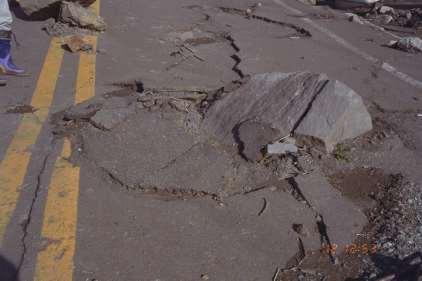
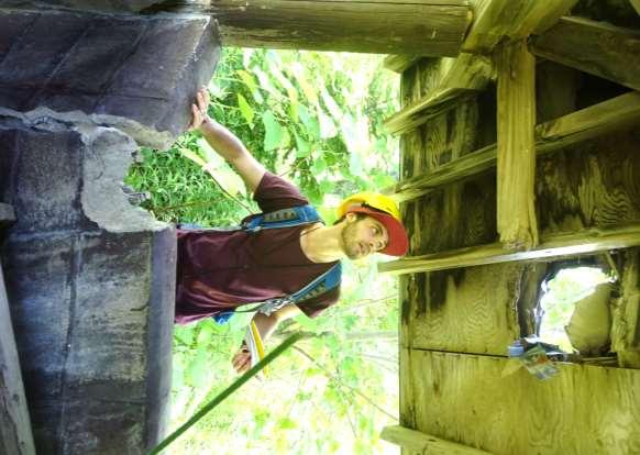
17 Severe building and infrastructure damage by ballistics
18

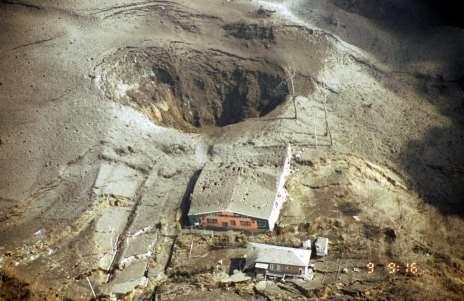
19 Severe building and infrastructure damage by ballistics
20 Take away messages Visited Mt Usu and Mt Ontake to learn more about ballistic impacts and Japanese risk management Ballistic risk management presents an immense challenge in populated areas NZ
21 Questions?? Thanks to: EQC, GNS and DeVoRA for funding this trip Ngai Tahu Research Centre for PhD scholarship Professors Yamaoka and Okada for sharing their data, photos and time.

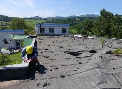
22 Recurring ballistic hazard The same buildings were damaged in the 1979 eruption but only repaired NIED report recommended building ballistic shelters but nothing was done


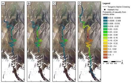
23 Ballistic mapping and casualty modelling


24 Post-eruption recovery Land use planning: Land in the worst impacted areas was bought by the Ministry of the Environment Turned into a Geopark educational/tourist attraction Becker et al Toya-usu-geopark.org


25 Hazard management Sabo dams Becker et al. 2010

26 Early warning systems? Both well monitored volcanoes with unheralded eruptions Had ~6-7 mins precursory activity before eruptions might be enough time to move people off summit or into shelters.
Land-use planning and volcanic hazards: Opportunities for New Zealand
 Land-use planning and volcanic hazards: Opportunities for New Zealand Julia Becker, Wendy Saunders, Graham Leonard, David Johnston, Lower Hutt Clare Robertson, Massey University, Palmerston North Presentation
( ) USGS (United States Geological Survey) Watch Green. Normal. alert level 1 Normal
 USGS (United States Geological Survey) Watch Green. Normal. alert level 1 Normal") (200610.1) USGS (United States Geological Survey) 1014 alert level 1 Normal Watch Green Normal USGS WARNING WATCH ADVISORY NORMAL SUMMARY OF VOLCANIC-ALERT LEVELS Highly hazardous eruption underway or
(200610.1) USGS (United States Geological Survey) 1014 alert level 1 Normal Watch Green Normal USGS WARNING WATCH ADVISORY NORMAL SUMMARY OF VOLCANIC-ALERT LEVELS Highly hazardous eruption underway or
Deterministic Ballistic Hazard Assessment of Mount Ruapehu, New Zealand
 1 2 3 4 5 6 7 8 9 10 11 12 13 14 15 16 17 18 19 20 21 22 23 24 25 26 27 28 29 30 31 32 33 34 35 36 37 38 39 40 41 42 43 44 Frontiers Abroad, New Zealand 10 June 2016 Deterministic Ballistic Hazard Assessment
LECTURE #11: Volcanoes: Monitoring & Mitigation
 GEOL 0820 Ramsey Natural Disasters Spring, 2018 LECTURE #11: Volcanoes: Monitoring & Mitigation Date: 15 February 2018 I. What is volcanic monitoring? the continuous collection of one or more data sources
Preparing for Eruptions What will happen in future eruptions and how can we be prepared?
 Lesson Plan 12 Activities 1. Read or listen to Matt s Volcano Story from What s the Plan Stan Stories on: http://www.whatstheplanstan.govt.nz/teacher.html#disasters Discuss what Matt saw and did before,
Wainui Beach Management Strategy (WBMS) Summary of Existing Documents. GNS Tsunami Reports
 Summary of Existing Documents. GNS Tsunami Reports") Wainui Beach Management Strategy (WBMS) Summary of Existing Documents GNS Tsunami Reports a) Review of Tsunami Hazard and Risk in New Zealand ( National Risk Report ) b) Review of New Zealand s Preparedness
Wainui Beach Management Strategy (WBMS) Summary of Existing Documents GNS Tsunami Reports a) Review of Tsunami Hazard and Risk in New Zealand ( National Risk Report ) b) Review of New Zealand s Preparedness
Understanding the impacts of an Auckland Volcanic Field eruption on Auckland s infrastructure
 Understanding the impacts of an Auckland Volcanic Field eruption on Auckland s infrastructure Graham Leonard & Natalia Deligne g.leonard@gns.cri.nz Roadmap DEVORA Research programme investigating all matters
Practical Example of the Use of a Volcano Hazard Map in 2000 Eruption of the Usu Volcano
 Practical Example of the Use of a Volcano Hazard Map in 2000 Eruption of the Usu Volcano Efforts by the town of Sobetsu for coexistence with ever-changing Earth Toshiya TANABE * 1. Introduction On March
Kadovar Eruption: Multi-Hazard Monitoring and Response
 2018/SOM1/EPWG/016 Agenda Item: 11.10 Kadovar Eruption: Multi-Hazard Monitoring and Response Purpose: Information Submitted by: Papua New Guinea 13 th Emergency Preparedness Working Group Meeting Port
Interpretive Map Series 24
 Oregon Department of Geology and Mineral Industries Interpretive Map Series 24 Geologic Hazards, and Hazard Maps, and Future Damage Estimates for Six Counties in the Mid/Southern Willamette Valley Including
Risk Management Strategy
 Risk Management Strategy 1 Purpose To protect the component parts of the World Heritage property as well as the lives and the property of visitors and residents from disasters such as volcanic eruptions,
Name: Page 1. 2) What do increases and decreases in RSAM data indicate about magma movement inside the volcano?
 What do increases and decreases in RSAM data indicate about magma movement inside the volcano?") Name: Page 1 Living on the Edge Unit 5: SEISMOLOGISTS A report on the seismic activity must be prepared in order to assess and forecast future activity. Complete the following components of the seismology
Name: Page 1 Living on the Edge Unit 5: SEISMOLOGISTS A report on the seismic activity must be prepared in order to assess and forecast future activity. Complete the following components of the seismology
Erupted and killed approximately 15,000 people 200 years ago
 1 2 3 4 5 6 7 8 Introduction to Environmental Geology, 5e Chapter 8 Volcanic Activity Volcanoes: summary in haiku form A volcano forms. Magma comes to the surface - explodes, if felsic. Case History: Mt.
Hazard assessment: Auckland Volcanic Field
 Hazard assessment: Auckland Volcanic Field Jan Lindsay SGGES & Institute of Earth Science and Engineering Hazard assessment The use of all available tools to determine the location, intensity, frequency
Hazard Resilience Index (HRI) Earthquakes, Tsunamis, and Volcanoes
 Earthquakes, Tsunamis, and Volcanoes") Hazard Index (HRI) Earthquakes, Tsunamis, and Volcanoes Earthquakes Tsunamis Volcano-Ash Falls, Projectiles and Lateral Blasts, Pyroclastic Flows and Lava Flows Earthquakes, Tsunamis and Volcanoes Please
Hazard Index (HRI) Earthquakes, Tsunamis, and Volcanoes Earthquakes Tsunamis Volcano-Ash Falls, Projectiles and Lateral Blasts, Pyroclastic Flows and Lava Flows Earthquakes, Tsunamis and Volcanoes Please
VOLCANO MONITORING PRACTICAL. Hazard alert levels established for communication at Mt. Pinatubo
 VOLCANO MONITORING PRACTICAL Predicting volcanic eruptions is a hazardous and stressful business. If an eruption has occurred and was not predicted then the volcanologists get the blame for not giving
Also, when Cascade volcanoes do erupt, high-speed avalanches of pyroclastic flows
 INTRODUCTION A volcano is a vent through which molten rock escapes to the Earth s surface. Unlike other mountains, which are pushed up from below, volcanoes are built by surface accumulation of their eruptive
GEOLOGY 285: INTRO. PETROLOGY
 Dr. Helen Lang Dept. of Geology & Geography West Virginia University FALL 2005 GEOLOGY 285: INTRO. PETROLOGY Mount St. Helens 1980 Eruption Small earthquakes Small steam and ash eruptions in March and
Module 1, Investigation 3: Predicting Eruptions
 Module 1, Investigation 3: Predicting Eruptions Introduction Welcome! Volcanoes are either "active" or "extinct". Active means that the volcano has erupted during the past 10,000 years. It can also mean
Debris Avalanches. Debris avalanche deposits on a volcano in Chile. All of the area in the foreground is buried by a thick debris avalanche.
 Debris Avalanches Volcanoes are not very stable structures. From time to time, they collapse producing large rock and ash avalanches that travel at high speeds down valleys. Collapse maybe caused by an
Volcanoes. Introduction
 Volcanoes Introduction Display Slide V-0 Explain that a volcano is a vent through which molten rock escapes to the Earth s surface. Unlike other mountains, which are pushed up from below, volcanoes are
Change detection at the recently erupted Te Maari crater, Tongariro, from stereo aerial photographs
 Change detection at the recently erupted Te Maari crater, Tongariro, from stereo aerial photographs Strong, D.T., Jones, K.E., Ashraf, S. and Lee, J. Outline Geographic context Setting and eruption Science
Level 2 Earth and Space Science, 2017
 91191 911910 2SUPERVISOR S Level 2 Earth and Space Science, 2017 91191 Demonstrate understanding of the causes of extreme Earth events in New Zealand 9.30 a.m. Thursday 30 November 2017 Credits: Four Achievement
Natural Processes. Were you prepared for the fast approaching storm? Were you able to take shelter? What about pets, livestock or plants?
 Have you ever been caught in a storm? You are outside on a summer night and all of a sudden here come the wind, lightning and heavy rain. It starts raining so hard that you can hardly see in front of you.
Year 9 Revision. The exam will be based on two topics: Natural hazards and Population. The Exam
 Year 9 Revision The exam will be based on two topics: Natural hazards and Population This document is designed to help you revise. You should use it alongside your class notes. In places there are some
Volcanoes. Environmental Geology, Mr. Paul Lowrey Stacey Singleton, Cassandra Combs, Dwight Stephenson, Matt Smithyman
 Volcanoes Environmental Geology, Mr. Paul Lowrey Stacey Singleton, Cassandra Combs, Dwight Stephenson, Matt Smithyman EMPACTS Project, Spring 2017 Northwest Arkansas Community College, Bentonville, AR
GIS modelling in support of earthquake-induced rockfall risk assessment in the Port Hills, Christchurch
 GIS modelling in support of earthquake-induced rockfall risk assessment in the Port Hills, Christchurch Biljana Lukovic, David Heron, William Ries & Chris Massey Natural Hazards Division GNS Science, Lower
Safety Procedures for Volcanic Activity in the United States and Japan
 Parkland College A with Honors Projects Honors Program 2015 Safety Procedures for Volcanic Activity in the United States and Japan Ashley Eisenmenger Parkland College Recommended Citation Eisenmenger,
Final Presentation on Disaster Risk Management in Japan. Through ADRC V. R Programme. Main Findings and Action Plan:
 Final Presentation on Disaster Risk Management in Japan Through ADRC V. R Programme Main Findings and Action Plan: Problem/Hazard and Disaster in Japan Good Practiced on Disaster Risk Management in Japan
2/25/2013. Volcanoes: summary in haiku form A volcano forms. Magma comes to the surface - explodes, if felsic.
 Introduction to Environmental Geology, 5e Edward A. Keller Chapter 8 Volcanic Activity Volcanoes: summary in haiku form A volcano forms. Magma comes to the surface - explodes, if felsic. Lecture Presentation
Key words: Volcano, hazard, risk communication, ballistic, bomb, Vanuatu, White island, Tongariro, Red Crater
 Assessing risk from ballistic impacts through aerial hazard mapping, numeric modelling, and laboratory experiments to enhance risk management and risk communication (EQC grant 16/727) Principal Investigator:
3/7/17. #16 - Case Studies of Volcanoes II. Announcements Monday 2/27
 Announcements Monday 2/27 Exam #1: Monday Feb. 27 th, 7:15-8:15 (see web site) Last Names A - N Loomis 141 Last Names O - Z Loomis 151 Bring your student ID An old exam is posted in Compass If you are
Aim: To be able to describe and explain techniques used to predict or reduce the impacts of volcanic eruptions in NAMED locations.
 C/W Qu: Can we predict volcanoes? 18/10/12 Aim: To be able to describe and explain techniques used to predict or reduce the impacts of volcanic eruptions in NAMED locations. Starter: Read and correct the
MANAGING VOLCANIC IMPACTS IN CANTERBURY. Tom Wilson University of Canterbury & Natural Hazard Research Platform
 MANAGING VOLCANIC IMPACTS IN CANTERBURY Tom Wilson University of Canterbury & Natural Hazard Research Platform Talk Outline Risk of a Volcanic eruption affecting Canterbury Putting it in context (likelihood/consequence)
United States Multi-Hazard Early Warning System
 United States Multi-Hazard Early Warning System Saving Lives Through Partnership Lynn Maximuk National Weather Service Director, Central Region Kansas City, Missouri America s s Weather Enterprise: Protecting
Predicting and Preparing for Volcanoes
 Predicting and Preparing for Volcanoes Prediction methods for volcanic eruptions are more reliable than those for earthquakes. Some volcanoes such as Mount Etna in Italy are monitored all of the time because
Advanced Workshop on Evaluating, Monitoring and Communicating Volcanic and Seismic Hazards in East Africa.
 2053-13 Advanced Workshop on Evaluating, Monitoring and Communicating Volcanic and Seismic Hazards in East Africa 17-28 August 2009 Hazard Communication: Examples From Tanzania, Mozambique, and Cameroon
FINAL EXAM December 20 th, here at 1:00 3:00 pm
 FINAL EXAM December 20 th, here at 1:00 3:00 pm REVIEW SESSION December 11 th at 6:00-7:30 pm Morrill I Auditorium (Room N375) Same as last time Don t forget your online course evaluations! Major Volcanic
GLG Ch 6: Volcanoes & Volcanic Hazards. 3. Name, describe (DSC) and draw the three types of volcanoes from smallest to largest.
 and draw the three types of volcanoes from smallest to largest.") GLG 101 - Ch 6: Volcanoes & Volcanic Hazards Name 6.1 What Is and and Is Not a Volcano? 1. Three common characteristics of a volcano include A B C 2. How did the Hopi Buttes (figure 06 01.b1) form? 3.
GLG 101 - Ch 6: Volcanoes & Volcanic Hazards Name 6.1 What Is and and Is Not a Volcano? 1. Three common characteristics of a volcano include A B C 2. How did the Hopi Buttes (figure 06 01.b1) form? 3.
GFS Geography Medium Term Plan Year 7 SUMMER
 Context: This unit investigates the processes that cause the Earth s plates to move and the landforms that result. It then investigates the interaction between people and these potentially hazardous environments.
Graham Leonard, Esline Garaebiti, Sylvain Todman, Sandrine Cevuard, Shadrack Welegtabit, Gill Jolly and Steve Sherburn
 Development of a collaborative consistent volcano communication framework in Vanuatu: Hazard maps, education, alert levels, bulletins, signs and procedures. Graham Leonard, Esline Garaebiti, Sylvain Todman,
Disclaimer. This report was compiled by an ADRC visiting researcher (VR) from ADRC member countries.
 from ADRC member countries.") Disclaimer This report was compiled by an ADRC visiting researcher (VR) from ADRC member countries. The views expressed in the report do not necessarily reflect the views of the ADRC. The boundaries and
Disclaimer This report was compiled by an ADRC visiting researcher (VR) from ADRC member countries. The views expressed in the report do not necessarily reflect the views of the ADRC. The boundaries and
EAS 116 Earthquakes and Volcanoes
 EAS 116 Earthquakes and Volcanoes J. Haase Forecasting Volcanic Eruptions Assessment of Volcanic Hazard Is that volcano active? Mount Lassen: 12000 BP and 1915 Santorini, IT: 180,000 BP, 70,000 BP, 21000
Assessing Hazards and Risk
 Page 1 of 6 EENS 204 Tulane University Natural Disasters Prof. Stephen A. Nelson Assessing Hazards and Risk This page last updated on 07-Jan-2004 As discussed before, natural disasters are produced by
Lesson 6: Predicting Eruptions. Grade Level 6-8. Volcanoes Educator Guide
 Lesson : Predicting eruptions Lesson : Predicting Eruptions Grade Level -8 Volcanoes Educator Guide Volcanoes Educator Guide Lesson : Predicting Eruptions Grade Level -8 () minute prep lesson () minute
Landforms from Volcanoes
 Landforms from Volcanoes Lesson Concept Link Volcanoes are classified by how they are formed (quiet or explosive eruption) and the resulting land formation (shield, cinder cone, or composite/stratovolcano).
GEOL1 Physical Geology Laboratory Manual College of the Redwoods Lesson Five: Volcanoes Background Reading: Volcanoes Volcanic Terms: Silca:
 Name: Date: GEOL1 Physical Geology Laboratory Manual College of the Redwoods Lesson Five: Volcanoes Background Reading: Volcanoes Volcanic Terms: Silca: SiO 2 silicon dioxide. This is quartz when it crystallizes.
Virtual Design Center Deliverable 4-2: Three Levels of Assessment
 Virtual Design Center Deliverable 4-2: Three Levels of Assessment Project Name Operation Montserrat Test Questions 1. Which of these is an immediate result of the movement of tectonic plates: a) Ocean
Risk Perception, Warning Systems and Evacuation Plans for Volcanic Hazards
 Dominican Scholar Collected Faculty and Staff Scholarship Faculty and Staff Scholarship 2007 Risk Perception, Warning Systems and Evacuation Plans for Volcanic Hazards Matt Davis Department of Psychology,
GENERAL. CHAPTER 1 BACKGROUND AND PURPOSE OF THE GUIDELINES Background of the Guidelines Purpose of the Guidelines...
 GENERAL CHAPTER 1 BACKGROUND AND PURPOSE OF THE GUIDELINES... 1 1.1 Background of the Guidelines... 1 1.2 Purpose of the Guidelines... 3 CHAPTER 2 APPLICATION OF THE GUIDELINES... 3 2.1 Potential Users
New Zealand s Next Top Model: integrating tsunami modelling into land use planning
 New Zealand s Next Top Model: integrating tsunami modelling into land use planning Wendy Saunders (MZNZPI), Gegar Prasetya, Graham Leonard GNS Science, Lower Hutt, w.saunders@gns.cri.nz In April 2011 a
Chapter: Earthquakes and Volcanoes
 Table of Contents Chapter: Earthquakes and Volcanoes Section 1: Earthquakes Section 2: Volcanoes Section 3: Earthquakes, Volcanoes, and Plate Tectonics 1 Earthquakes What causes earthquakes? Elastic Rebound
Montserrat Eruption = Monster rat
 Montserrat Eruption 1997 = Monster rat Small island in the Caribbean sea Montserrat is a small... Soufriere Hills volcano Key facts: Date: 25 th June 1997 (small eruptions began in July 1995) Size: 4.5
Hazard assessment and risk mitigation for tourists at Hekla volcano, South Iceland. Jorge Montalvo Magnús Tumi Guðmundsson
 Hazard assessment and risk mitigation for tourists at Hekla volcano, South Iceland Jorge Montalvo Magnús Tumi Guðmundsson Volcandpark. Olot, Cataluña 25th of May 2012 1 Overview Introduction Classification
Assessing the Volcanic Threat in Latin America. Jose L. Palma, University at Buffalo Bill Rose, Michigan Technological University
 Assessing the Volcanic Threat in Latin America Jose L. Palma, University at Buffalo Bill Rose, Michigan Technological University PASI Workshop, January 2011 Natural Disasters by Type, 1991-2005 90% 7%
How to communicate Cascadia Subduction Zone earthquake hazards
 How to communicate Cascadia Subduction Zone earthquake hazards Tom Brocher Research Geophysicist Earthquake Science Center U.S. Geological Survey Menlo Park, California Seattle Post-Intelligencer Lessons
The Orting Community College of Vulcanology
 The Orting Community College of Vulcanology A Recommendation For His Honourable Mayor A. Young By DAG (Doom-and-Gloom), LLP (Michael, Chris, Bryan, Lauren, Dave) Agenda 1. 2. 3. 4. 5. 6. Description of
25. National warnings and advisories
 25. National warnings and advisories Summary Warnings and advisories are used to advise agencies, authorities, and/or the public of threats, enabling them to take appropriate action. Contents The section
Released Science Inquiry Task Encounter with an Active Volcano Grade 11
 Date: Your Name: Released Science Inquiry Task Encounter with an Active Volcano 2016 Grade 11 Directions: Science You will be reading a story and analyzing the data provided to answer a set of questions.
Outline of Guideline for Development and Utilization of Tsunami Disaster Management Map
 Outline of Guideline for Development and Utilization of Tsunami Disaster Management Map Port and Airport Research Institute, Japan The Overseas Coastal Area Development Institute of Japan Ports and Harbours
KNOWLEDGE NOTE 5-1. Risk Assessment and Hazard Mapping. CLUSTER 5: Hazard and Risk Information and Decision Making. Public Disclosure Authorized
 Public Disclosure Authorized Public Disclosure Authorized Public Disclosure Authorized Public Disclosure Authorized KNOWLEDGE NOTE 5-1 CLUSTER 5: Hazard and Risk Information and Decision Making Risk Assessment
Kīlauea Volcano: Be a Volcanologist. Image Credit: Julien Millet / Unsplash. Final Project
 The Kīlauea Volcano: Be a Volcanologist Image Credit: Julien Millet / Unsplash Final Project Final Project The Kīlauea Volcano: Be a Volcanologist In this two-day project, students apply their previous
Earthquakes Science & Safety. Dr. Richard Robertson Geologist & Head Seismic Research Unit
 Earthquakes Science & Safety Dr. Richard Robertson Geologist & Head Seismic Research Unit Summary The Eastern Caribbean islands are in a seismically active part of the world. Earthquake safety tips should
Lessons Learned from Past Tsunamis Warning and Emergency Response
 UNESCO IOC CTIC US NOAA ITIC Regional Training Workshop on Strengthening Tsunami Warning and Emergency Response Standard Operating Procedures and the Development of the ICG/CARIBE-EWS PTWC New Enhanced
Volcanoes. Volcanoes July 2004
 Volcanoes Learn about your community s risk from hazards created by volcanic eruptions. While you may be located far from a volcano, the ash from an explosive eruption could affect your area. Contact your
Publishable Summary. Summary Description of the project context and main objectives
 Publishable Summary Summary Description of the project context and main objectives Tsunamis are low frequency but high impact natural disasters. In 2004, the Boxing Day tsunami killed hundreds of thousands
Volcanoes Shake and Bake Indoor Activity
 Mount St Helens National Volcanic Monument Teacher s Corner 2011 Gifford Pinchot National Forest USDA Forest Service Volcanoes Shake and Bake Indoor Activity Time Commitment: Trail: Location: 45 minutes
Living Near a Volcano
 living near a volcano Grade Level 3-5 Grade Level 3-5 (1) 15 minute prep lesson (3) 45 minute lessons Lesson overview: Is it possible to build a volcano-safe home? In this lesson, students will learn about
Images from: Boston.com
 Images from: Boston.com Ireland in the shadow of a volcano: Understanding the 2010 eruption at Eyjafjallajökull, Iceland. Chris Bean, School of Geological Sciences, UCD. World Quakes and Volcanoes 1960-2010
Figure 8-21 Distribution of Lava Flow for the Model
 Figure 8-21 Distribution of Lava Flow for the Model 2) Pyroclastic Flow The energy cone model was used for the simulation. a. The angle of inclination of Energy Line, φ, from the summit was 5.3 degrees
 Hazard Warnings GE 4150 Natural Hazards September 17, 2007 http://www.sdr.gov/ndis_rev_oct27.pdf Sorensen, J.H. (2000) Hazard warning systems: Review of 20 years of progress. Natural Hazards Review, May,
Situation Report. Situation Overview. Volcanic Activity Ambae & Ambrym. Situation Report 08. Time & Date 17:00 18 th October 2017
 Situation Report Response Name Volcanic Activity Ambae & Ambrym Situation Report 08 Time & Date 17:00 18 th October 2017 Reporting period 18/10/2017 Provinces affected Penama, Sanma, Malampa Attachment(s)
Tsunami hazard risk and early warning projects at Global Geophysics Institute, Vietnam
 Tsunami hazard risk and early warning projects at Global Geophysics Institute, Vietnam presented by Dr Kelvin Berryman, GNS Science, New Zealand k.berryman@gns.cri.nz on behalf of Prof. Bui C. Que,, Director
What Are Disasters? The Rescue Kids Trio!
 The Rescue Kids Trio! What Are Disasters? This manual was made possible through funding by the Council of Local Authorities for International Relations. Disasters and emergency preparedness Emergency preparedness
Volcanoes. 11/25/2013. Geology 15 Lecture 27 VOLCANO!
 Hazard Update Surprise POP Review Tsunami Activity 10 B Today s Material Volcanoes Volcanic Hazards Geology 15 Lecture 27 VOLCANO! http://motherboard.vice.com/blog/watch an erupting volcano create a newisland
Growth of International Collaboration in Monitoring Volcanic Ash Eruptions in the North Pacific
 Growth of International Collaboration in Monitoring Volcanic Ash Eruptions in the North Pacific John C. Eichelberger and Christina Neal U.S. Geological Survey U.S. Department of the Interior U.S. Geological
GRADE VI BEING PREPARED DURING VOLCANIC ACTIVITIES
 GRADE VI BEING PREPARED DURING VOLCANIC ACTIVITIES At the end of the module, you should be able to: Differentiate an active from an inactive volcano Describe the harmful effects of a volcanic eruptions
Homework III. Volcanological Exercises
 Page 1 of 5 EENS 3050 Tulane University Natural Disasters Prof. Stephen A. Nelson Homework III. Volcanological Exercises This page last updated on 16-Feb-2018 1. In your work as an insurance company executive
Take a Chance on the volcano erupting How hazardous is the volcano?
 Earthlearningidea - http://www.earthlearningidea.com/ Take a Chance on the volcano erupting How hazardous is the volcano? Earth Learning Idea has already published Party time for volcanoes! How much force
Earthquake Hazards. Tsunami
 Earthquake Hazards Tsunami Review: What is an earthquake? Earthquake is the vibration (shaking) and/or displacement of the ground produced by the sudden release of energy. The point inside the Earth where
Describe the layers of the Earth Understand what plates are and how they move
 Lesson links Lesson 1 layers of the earth and plate boundaries Lesson 2 How and why a volcano erupts Lesson 3 The impacts of a volcanic eruption Mt St Helen s (learning Milestone) Lesson 4 How an earthquake
Geohazards and disaster risk reduction
 Geohazards and disaster risk reduction Susanne Sargeant 8 November 2017 Overview University and my PhD Seismology at BGS Learning other skills Working at the interface between science and resilience building
Guidance for GEOGRAPHY End of Year Examination 2016
 Guidance for GEOGRAPHY End of Year Examination 2016 The End of Year Examination takes place in Week 4 of the Summer Term. The Geography Examination will last 50 minutes. The Examination will include questions
Establishment and Operation of a Regional Tsunami Warning Centre
 Establishment and Operation of a Regional Tsunami Warning Centre Dr. Charles McCreery, Director NOAA Richard H. Hagemeyer Pacific Tsunami Warning Center Ewa Beach, Hawaii USA Why A Regional Tsunami Warning
Hazard Warnings and Warning Systems
 Hazard Warnings and Warning Systems Lecture Objectives: -Know the main features and limitations of our national warning system -learn the key features of an effective warning system Sorensen, J.H. (2000)
Lessons from the 2004 Sumatra earthquake and the Asian tsunami
 Lessons from the 2004 Sumatra earthquake and the Asian tsunami Kenji Satake National Institute of Advanced Industrial Science and Technology Outline 1. The largest earthquake in the last 40 years 2. Tsunami
11. Shake It Out 12/06/2016
 11. Shake It Out 12/06/2016 EQOD : How do citizens determine the best thing to do in an emergency? Initial Thoughts: In a Level 0 Silence Voice, take 5 minutes to answer the question. If you still have
Year 11 Geography GCSE Assessment Booklet Section A: The challenge of natural hazards
 Year 11 Geography GCSE Assessment Booklet Section A: The challenge of natural hazards Question Mark & Grade 9 1 Explain why the majority of earthquakes and volcanoes occur at plate margins (6 marks) Choose
Chapter 4. The Earth s Surface: Shaping the crust
 Chapter 4 The Earth s Surface: Shaping the crust Learning outcomes In this chapter you will learn: That the earth is made up of layers Why the earth is shaped as it is What plates are and how they move
City of Punta Gorda Community Emergency Management Plan 2013
 City of Punta Gorda Community Emergency Management Plan 2013 Hurricane Andrew- August 24, 1992 Category 5 hurricane. The second-most-destructive hurricane in U.S. history. The first named storm of the
Earthquakes Science & Safety. Ms Joan L. Latchman Seismologist Seismic Research Unit
 Earthquakes Science & Safety Ms Joan L. Latchman Seismologist Seismic Research Unit Summary Trinidad lies in an area of high earthquake activity for the Caribbean. Earthquake safety tips should be practiced
The Cascading Hazards from Cascadia s Earthquakes
 Tsunamis The Cascading Hazards from Cascadia s Earthquakes Earthquakes (Nisqually earthquake, Seattle, WA) Volcanoes (Mt St Helens eruption, WA) Joan Gomberg gomberg@usgs.gov Landslides (Oso landslide,
GEOLOGY 285: INTRO. PETROLOGY
 Dr. Helen Lang Dept. of Geology & Geography West Virginia University SPRING 2015 GEOLOGY 285: INTRO. PETROLOGY The Cascade Volcanoes are a good example of the Circum- Pacific ring of fire of subductionrelated
Emergency Situation Report, 18 April 2005
 WHO Indonesia Emergency and Humanitarian Action (EHA) Section Emergency Situation Report, 18 April 2005 Up-date on Increased Volcanic Activities in Indonesia Krakatau Talang Padang Tangkuban Perahu Jakarta
Chapter 5 THE DEVELOPMENT OF VOLCANIC EMERGENCY PLANS. 5.1 Introduction
 Chapter 5 THE DEVELOPMENT OF VOLCANIC EMERGENCY PLANS 5.1 Introduction It will be assumed in this chapter: (0) That in any community exposed to volcanic hazards there is general awareness of the hazard
GUIDELINES FOR CONSTRUCTION TECHNOLOGY TRANSFER DEVELOPMENT OF WARNING AND EVACUATION SYSTEM AGAINST SEDIMENT DISASTERS IN DEVELOPING COUNTRIES
 GUIDELINES FOR CONSTRUCTION TECHNOLOGY TRANSFER DEVELOPMENT OF WARNING AND EVACUATION SYSTEM AGAINST SEDIMENT DISASTERS IN DEVELOPING COUNTRIES MARCH 2004 Ministry of Land, Infrastructure and Transport
Two-Dimensional Stability and Seismic Loading Models of Crater Lake Outlet, Mount Ruapehu, New Zealand
 Two-Dimensional Stability and Seismic Loading Models of Crater Lake Outlet, Mount Ruapehu, New Zealand Grace Guryan, Marlène Villenueve, Samuel Hampton G. Guryan a (corresponding author: grace.guryan@coloradocollege.edu)
DEBRIS FLOW DISASTER MITIGATION THROUGH COMMUNITY-BASED INTEGRATED SEDIMENT MANAGEMENT (BEST PRACTICE IN MT. MERAPI AREA, INDONESIA)
") Civil Engineering Forum Volume XXI/3 - September 2012 DEBRIS FLOW DISASTER MITIGATION THROUGH COMMUNITY-BASED INTEGRATED SEDIMENT MANAGEMENT (BEST PRACTICE IN MT. MERAPI AREA, INDONESIA) K. Otani Yachiyo
Civil Engineering Forum Volume XXI/3 - September 2012 DEBRIS FLOW DISASTER MITIGATION THROUGH COMMUNITY-BASED INTEGRATED SEDIMENT MANAGEMENT (BEST PRACTICE IN MT. MERAPI AREA, INDONESIA) K. Otani Yachiyo
Geography. Sixth Form Examination Mark Scheme
 Geography Sixth Form Examination 2015 Mark Scheme Sixth Form Specimen Examination Mark Scheme - Geography All Questions are compulsory SECTION A 1. Use the picture of Mount Ontake and draw a labelled sketch