Responders Organized for Pass Emergencies (ROPE)
|
|
|
- Marcia Antonia Franklin
- 5 years ago
- Views:
Transcription
 Miles H.")


1 Responders Organized for Pass Emergencies (ROPE) Miles H. Wagner Emergency Services Officer San Bernardino County Fire Department Office of Emergency Services Mark A. Hartwig Fire Chief/Fire Warden
2 ROPE Goal The ROPE Field Operations Guide (FOG) and Standard Operating Guidelines (SOG) were developed to assist first responders in - preparing for, - responding to, - recovering from, and - mitigating a significant or catastrophic incident within the Cajon Pass area of San Bernardino County.
3 Development The first ROPE Plan was developed in the 1990 s by the Office of Emergency Services in response to fires and transportation accidents that closed the Cajon Pass for several days at a time. In 2012, the need for a new and comprehensive ROPE Plan was recognized by the Office of Emergency Services. This started a three year effort to produce a comprehensive and usable plan.
4 Stakeholders Cajon Pass stakeholders include USFS, BLM; State agencies (CalFire, CalTrans, CHP, DWR, DFG), San Bernardino County Fire Department, Sheriff s Department, Public Works, Flood Control, County Museum, public utilities including Southern California Edison and the City of Los Angeles Department of Water and Power, Burlington Northern Santa Fe and Union Pacific Railroads; Kinder- Morgan Pipelines, The Gas Company; etc. It total there were 28 agencies involved in the development of the ROPE FOG/SOG. All stakeholders were part of the ROPE Committee. Subject matter experts were drawn from the stakeholders where possible.
5 Purpose of ROPE: 1. Provide common communications plan 2. Provide locations for: Incident Command Post Staging Areas Helispots Helibase Camps Fire Stations Fuel locations Water sources Evacuation Centers Arial Hazards School Sites Parks Pipelines Electrical Transmission Lines Railroads Critical Routes
6 USE First responders with primary responsibility for the Cajon Pass have ROPE FOGs in their response vehicles A Cache of FOGS is available for distribution for any first responders assigned to an incident from out of the area An electronic version is also available to first responders The first edition of ROPE FOGs was limited to 200 copies
7 Required Analysis In order to develop the ROPE FOG, a thorough analysis of the Cajon Pass was needed Analysis was conducted on three areas of information: 1. Geographic Setting 2. Hazard/Risks 3. Infrastructure Additional analysis was conducted on: - Responders Recovery Needs - Responders Communications Interoperability
8 Geographic Setting The Cajon Pass is a mountain pass between the San Bernardino and San Gabriel Mountains, created by movements of the San Jacinto Section of the San Andreas Fault. The pass rises 2,200 from 2,000 to 4,200 at Cajon Summit in about 13 ¼ miles The area is covered with chaparral brush with a few intermittent streams Access is severely limited

9 Geographic Area
10 Critical Infrastructure Cajon Pass Critical Transportation Route from s. California to the rest of the United States - Highways - Railroads - Electrical Transmission Lines - Refined Petroleum Pipelines - Natural Gas pipelines - Communications Infrastructure
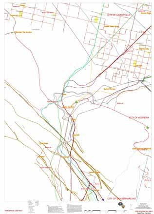
11 Critical Infrastructure
12 HAZARDS Natural Hazards - Earthquake - Fire - Flood - Wind Manmade Hazards - Railroad Accidents - Highway Accidents - Powerline Accidents - Pipeline Accidents

13 Manmade Hazards

14 Natural Hazards
15 Spatial Analysis Spatial Analysis was conducted on three types of information: - Geographic Area - Hazards/Threats - Critical Infrastructure Stakeholders personal knowledge of the Cajon Pass made the collection of data and spatial analysis easier - Where personal knowledge was weak, Subject Matter Experts (SME s) were consulted Recognition of lack of expertise in a particular area and the use of SME s made for accurate analysis.
16 Spatial Analysis Experts Spatial analysis was conducted by the GIS Specialist at the Office of Emergency Services and selected stakeholders Subject Matter Experts were used wherever possible to assist and validate data analysis for the Cajon Pass The SME s were drawn from the ROPE Committee created to develop a comprehensive Field Operations Guide (FOG) and Standard Operating Guidelines (SOG) for first responders to the Cajon Pass after an earthquake or other significant or catastrophic incident that impacts the Pass.
17 Geographic Spatial Analysis Analysis of the geography of Cajon Pass was done by review of maps for hazards: Natural - Waterways - Faults - Terrain - Landslides - Vegetation Manmade - Earth Cuts/Fills - Infrastructure Location All analysis was confirmed by field confirmation and ROPE Committee review.
18 Hazard/Threat Analysis Analysis of the Hazards/Threats was conducted: - Earthquake Faults/Known earthquakes - Historic - Prehistoric - Flooding and flood channels - Weather Records - Flood Channels - Fires - Fire Records - Personal Fire Suppression Knowledge of ROPE members Locations were plotted on maps
19 Analysis of Critical Infrastructure was completed on: Roadways - Freeways - State Highways - Critical Routes - Priority Routes Railroads - BNSF - UP Pipelines - Natural Gas - Refined Petroleum Products Water Sources - Wells - Reservoirs - Ponds/lakes Electrical Distribution Systems Commercial Business Sites - Fuel - Lodging - Dangerous Locations - Hazmat - Exotic Animals
20 Critical Infrastructure

21 Combined Spatial Analysis Results
22 Analysis Conclusions Time Closure Lasts - Fire Closure Hours to Days - Transportation Accident Hours to Days - Earthquake Weeks to Months Effect: - Up to 20,000 people stranded in Cajon Pass - Electrical Supply Disrupted - Gas Supply Disrupted - Freight Distribution Interrupted - Communications Interrupted Economic Costs
23 Spatial Analysis Hints Obtain the best data possible Verify all data - Some data was not properly located - Agencies are in the process of correcting data Field review of analysis to validate conclusions Confirm locations of all Incident specific pre-planned sites at least annually. Any similar development requires a cooperative effort by all stakeholders.
24 Display of Spatial Analysis Results

25 Insert ROPE cover here

26 ROPE FOG Scope - Contents Westbound I210 at Roxford St. February 9, 1971 E ticket ride!
27 ROPE FOG Scope Interoperable communications planning guidance Communications Plan template Pre-identified communications capabilities Detailed maps of the Cajon Pass (21 maps total) 4 Branches, each with 4 Divisions Each Division Map has an Information Sheet Information sheet contains: Existing Infrastructure/Scene Safety Available Water Supply Communications Issues Local Response Agencies/Facilities Access Routes Potential Staging/ICP/LZ/Fuel Locations

28 Cajon Pass Branch Map

29 Detailed Information Sheet

30 Division Map
31 ADDITIONAL ICS FORMS INCLUDED Additional ICS Forms include: - ICS 201 Resource Summary - ICS 202 Incident Objectives - ICS Organization Assignment List - ICS 205 Incident Radio Communications Plan - ICS 207 Incident Organization Chart Having forms available allows for rapid implementation of the Incident Command System
32 FORMAT ROPE FOG: - Tabloid size (11 x 17 ) in landscape orientation - Color Ink - Double sided printing - Laminated - Can be written on with markers or grease pencil - Wire bound on the top (long) side NOTE: - Maps and Information Pages are portrait orientation due to the geographic footprint of the Cajon Pass Cost: - Each ROPE FOG is about $40.


33 Tabletop/ Field Exercise September 24, 2013
34 Recognition National Association of Counties - Achievement Award - June,2014 Model Plan - Other jurisdictions now following our footsteps in developing similar plans
35 Questions? Contact Information:
2014 San Gabriel Valley Water Forum. October 2, 2014
 2014 San Gabriel Valley Water Forum October 2, 2014 Panel 3 Are we Ready? Flooding, Fires and Earthquakes Don Boland, California Utilities Emergency Association Southern California Catastrophic Earthquake
4.1 Hazard Identification: Natural Hazards
 data is provided in an annex, it should be assumed that the risk and potential impacts to the affected jurisdiction are similar to those described here for the entire Sacramento County Planning Area. This
Flood Scenario Worksheet
 Flood Scenario Worksheet Scenario adapted from: http://www.epa.gov/watersecurity/tools/trainingcd/simple/source/scenario-8/ssc8-0.pdf Simple Tabletop Exercise, Interdependency Natural Disaster Scenario,
STEUBEN COUNTY, NEW YORK. Hazard Analysis Report
 STEUBEN COUNTY, NEW YORK Hazard Analysis Report Prepared by: April 1, 2014 Background On April 1, 2014 the Steuben County Office of Emergency Management conducted a hazard analysis using the automated
City of Saginaw Right of Way Division Snow and Ice Removal Policy January 18, 2016
 Snow and Ice Removal Policy January 18, 2016 It is the policy of the to provide snowplowing and ice removal services in order to: Provide safe traveling conditions for motorists and pedestrians Assist
Hazard Vulnerability Analysis Union County
 Hazard Vulnerability Analysis Union County Union County Geographic Description Union County is located in northeastern Oregon and bordered by Baker and Grant County to the south, Wallowa County to the
Dunn County Snow Removal Policy
 Dunn County Snow Removal Policy OVERVIEW With the advent of another winter season in the northern plains comes the possibility of snow, freezing rain and slippery roadways, and area resident s concern
WHAT HAPPENS WHEN A TORNADO STRIKES THE COMMUNITY? Carroll County Sheriff s Office Emergency Management
 WHAT HAPPENS WHEN A TORNADO STRIKES THE COMMUNITY? Carroll County Sheriff s Office Emergency Management WHAT IS EMERGENCY MANAGEMENT? Carroll County Sheriff s Office Emergency Management Agency is responsible
West Hollywood General Plan
 ITEM 2.RR. EXHIBIT B Providing a safe living environment is a fundamental goal and one of the most important challenges cities face today. Anticipating, planning for, and guarding against threats to public
Emergency Action Guidelines for NH 4-H Animal Events
 Emergency Action Guidelines for NH 4-H Animal Events Purpose: This plan outlines guidelines designed to help ensure NH 4-H Animal Events and Shows are prepared for emergencies and severe weather conditions.
May 31, Flood Response Overview
 May 31, 2013 Flood Response Overview Suppression 867 Personnel on three (3) shifts 289 Red Shift (A) 289 Blue Shift (B) 289 Green Shift (C) Department Overview Department Overview EMS: 40,934 False Alarm:
WINTER STORM Annex II
 WINTER STORM Annex II I. PURPOSE A. This annex has been prepared to ensure a coordinated response by state agencies to requests from local jurisdictions to reduce potential loss of life and to ensure essential
Baldwin County, Alabama
 2015 Baldwin County, Alabama Multi-Hazard Mitigation Plan I. Comprehensive Plan A multi-jurisdiction plan City of Bay Minette City of Daphne Town of Elberta City of Fairhope City of Foley City of Gulf
2014 Russell County Hazard Mitigation Plan Update STAKEHOLDERS AND TECHNICAL ADVISORS MEETING 2/6/14
 2014 Russell County Hazard Mitigation Plan Update STAKEHOLDERS AND TECHNICAL ADVISORS MEETING 2/6/14 Welcome and Introductions We cannot direct the wind, but we can adjust our sails. 44 CFR 201.6; Local
Southern California Edison Wildfire Mitigation & Grid Resiliency
 Southern California Edison Wildfire Mitigation & Grid Resiliency California State Legislative Conference Committee on Wildfire Preparedness and Response August 7, 2018 CALIFORNIA S WILDFIRE RISK Year-Round
ICE STORM! a mini tabletop exercise for home care agencies
 1 ICE STORM! a mini tabletop exercise for home care agencies HCA Education and Research Winter 2010 2011 2 What is a tabletop exercise? People come together to review and discuss a hypothetical emergency
Southern California Edison ESRB-8 Report Regarding Pro-Active De-Energization Event December 29 to January 1, 2019
 Southern California Edison Submitted to: California Public Utilities Commission Director of the Safety and Enforcement Division January 15, 2019 Southern California Edison (SCE) submits the following report
Weather Information for Surface Transportation (WIST): Update on Weather Impacts and WIST Progress
: Update on Weather Impacts and WIST Progress") Weather Information for Surface Transportation (WIST): Update on Weather Impacts and WIST Progress Samuel P. Williamson Office of the Federal Coordinator for Meteorological Services and Supporting Research
Weather Information for Surface Transportation (WIST): Update on Weather Impacts and WIST Progress Samuel P. Williamson Office of the Federal Coordinator for Meteorological Services and Supporting Research
DEVELOPING A TRANSPORTATION PLAN FOR EVACUATION OF BUILDUP AREAS IN CASE OF EARTHQUAKE "CASE STUDY"
 DEVELOPING A TRANSPORTATION PLAN FOR EVACUATION OF BUILDUP AREAS IN CASE OF EARTHQUAKE "CASE STUDY" Osama A. Abaza Associate Professor, Civil Engineering Dept., University of Alaska Anchorage, Anchorage,
CALIFORNIA GOVERNOR'S OFFICE OF EMERGENCY SERVICES CAL OES CALIFORNIA DEPARTMENT OF FORESTRY AND FIRE PROTECTION CAL FIRE
 CALIFORNIA GOVERNOR'S OFFICE OF EMERGENCY SERVICES CAL OES CALIFORNIA DEPARTMENT OF FORESTRY AND FIRE PROTECTION CAL FIRE California Joint Incident Briefing 7/4/28 4: hours Weather Report - Northern Region
Complete Weather Intelligence for Public Safety from DTN
 Complete Weather Intelligence for Public Safety from DTN September 2017 White Paper www.dtn.com / 1.800.610.0777 From flooding to tornados to severe winter storms, the threats to public safety from weather-related
Lessons Learned and Shared
 Lessons Learned and Shared Plan for the worst. Hope for the best. Remember that hope is not a strategy. Agnes 8 Lessons 1. Identify Susceptible Communities 2. Develop a Plan 3. Threat Recognition 4. Review
2014 Annual Mitigation Plan Review Meeting
 2014 Annual Mitigation Plan Review Meeting Highland County EMA MEETING OBJECTIVES Understand Your Natural Disaster Risk Review of Previous Plans Current Plan Status Future Activity Plan/Needs of Each Community
APPLICATIONS OF EARTHQUAKE HAZARD MAPS TO LAND-USE AND EMERGENCY PLANNING EXAMPLES FROM THE PORTLAND AREA
 APPLICATIONS OF EARTHQUAKE HAZARD MAPS TO LAND-USE AND EMERGENCY PLANNING EXAMPLES FROM THE PORTLAND AREA O. Gerald Uba Metro, Portland, Oregon OVERVIEW The extent to which we understand "below ground"
2018 NASCIO Award Submission Category: Cross-Boundary Collaboration and Partnerships. Project Title: Tennessee Wildfires: A Coordinated GIS Response
 2018 NASCIO Award Submission Category: Cross-Boundary Collaboration and Partnerships Project Title: Tennessee Wildfires: A Coordinated GIS Response Sevier County, Tennessee State of Tennessee, Emergency
Improvement of the National Hydrography Dataset for Parts of the Lower Colorado Region and Additional Areas of Importance to the DLCC
 Improvement of the National Hydrography Dataset for Parts of the Lower Colorado Region and Additional Areas of Importance to the DLCC Carlos Reyes-Andrade California State University, Northridge September
INDIANA ACADEMIC STANDARDS FOR SOCIAL STUDIES, WORLD GEOGRAPHY. PAGE(S) WHERE TAUGHT (If submission is not a book, cite appropriate location(s))
 WHERE TAUGHT (If submission is not a book, cite appropriate location(s))") Prentice Hall: The Cultural Landscape, An Introduction to Human Geography 2002 Indiana Academic Standards for Social Studies, World Geography (Grades 9-12) STANDARD 1: THE WORLD IN SPATIAL TERMS Students
Prentice Hall: The Cultural Landscape, An Introduction to Human Geography 2002 Indiana Academic Standards for Social Studies, World Geography (Grades 9-12) STANDARD 1: THE WORLD IN SPATIAL TERMS Students
PUBLIC SAFETY POWER SHUTOFF POLICIES AND PROCEDURES
 PACIFIC GAS AND ELECTRIC COMPANY PUBLIC SAFETY POWER SHUTOFF POLICIES AND PROCEDURES SEPTEMBER 2018 1 PACIFIC GAS AND ELECTRIC COMPANY PUBLIC SAFETY POWER SHUTOFF POLICIES AND PROCEDURES SEPTEMBER 2018
On Page 1, following Paragraph 2 of the Planning Participants subsection, insert the following: 2012 Committee members included:
 Appendix 4: City of West Linn Addendum to the Clackamas County Natural Hazards Mitigation Plan 2012 Amendments and Update The Oregon Partnership for Disaster Resilience prepared this Appendix to the City
Physical Geography: Patterns, Processes, and Interactions, Grade 11, University/College Expectations
 Geographic Foundations: Space and Systems SSV.01 explain major theories of the origin and internal structure of the earth; Page 1 SSV.02 demonstrate an understanding of the principal features of the earth
GREEN SHEET. California Department of Forestry and Fire Protection (CAL FIRE)
") GREEN SHEET California Department of Forestry and Fire Protection (CAL FIRE) Informational Summary Report of Serious CAL FIRE Injuries, Illnesses, Accidents and Near-Miss Incidents Electrical Shock Downed
GREEN SHEET California Department of Forestry and Fire Protection (CAL FIRE) Informational Summary Report of Serious CAL FIRE Injuries, Illnesses, Accidents and Near-Miss Incidents Electrical Shock Downed
John Laznik 273 Delaplane Ave Newark, DE (302)
") Office Address: John Laznik 273 Delaplane Ave Newark, DE 19711 (302) 831-0479 Center for Applied Demography and Survey Research College of Human Services, Education and Public Policy University of Delaware
Office Address: John Laznik 273 Delaplane Ave Newark, DE 19711 (302) 831-0479 Center for Applied Demography and Survey Research College of Human Services, Education and Public Policy University of Delaware
The Tampa Bay Catastrophic Plan Presentation to CFGIS Users Group FDOT District 5 Urban Offices - Orlando July 30, 2010
 The Tampa Bay Catastrophic Plan Presentation to CFGIS Users Group FDOT District 5 Urban Offices - Orlando July 30, 2010 Brady Smith Senior Planner Tampa Bay Regional Planning Council Introduction Recent
Dust Storms in Arizona: The Challenge to Ensure Motorist Safety Jennifer Toth, P.E. Deputy Director for Transportation
 Dust Storms in Arizona: The Challenge to Ensure Motorist Safety Jennifer Toth, P.E. Deputy Director for Transportation Arizona Department of Transportation AASHTO Extreme Weather Event Symposium May 21,
CATEX Hurricane Zachary
 CATEX Hurricane Zachary EXERCISE, EXERCISE,EXERCISE East Coast CATEX Power Restoration Functional Exercise 2013 This document was prepared under a grant from FEMA's Grants Programs Directorate, U.S. Department
Chapter 1 Overview of Maps
 Chapter 1 Overview of Maps In this chapter you will learn about: Key points when working with maps General types of maps Incident specific maps Map legend and symbols Map sources A map is a navigational
Comprehensive Emergency Management Plan
 Comprehensive Emergency Management Plan Section 6-Earthquake Annex Blank Intentionally 2 CEMP Annex 6 1 Earthquake Annex I. PURPOSE II. SITUATION The earthquake annex is a hazard-specific annex to be used
RISK ASSESSMENT COMMUNITY PROFILE NATURAL HAZARDS COMMUNITY RISK PROFILES. Page 13 of 524
 RISK ASSESSMENT COMMUNITY PROFILE NATURAL HAZARDS COMMUNITY RISK PROFILES Page 13 of 524 Introduction The Risk Assessment identifies and characterizes Tillamook County s natural hazards and describes how
APPENDIX V VALLEYWIDE REPORT
 APPENDIX V VALLEYWIDE REPORT Page Intentionally Left Blank 1.2 San Joaquin Valley Profile Geography The San Joaquin Valley is the southern portion of the Great Central Valley of California (Exhibit 1-1).
SPEARFISH FIRE DEPARTMENT POLICIES AND PROCEDURES
 SPEARFISH FIRE DEPARTMENT POLICIES AND PROCEDURES Page 1 of 5 Volume: Operation Section: 20.00 Number: 20.09 Subject: Weather Watches, Warnings, Advisory s and Spotter Activation Date Issued: 28 March
Crime Analysis. GIS Solutions for Intelligence-Led Policing
 Crime Analysis GIS Solutions for Intelligence-Led Policing Applying GIS Technology to Crime Analysis Know Your Community Analyze Your Crime Use Your Advantage GIS aids crime analysis by Identifying and
COMMENT CARD RESPONSES (SEISMIC)
") COMMENT CARD 1 1. Please explain once and for all why the original route isn t an option while it s safer and cheaper, instead of going under the high school? Response: Please refer to the November Community
COMMENT CARD 1 1. Please explain once and for all why the original route isn t an option while it s safer and cheaper, instead of going under the high school? Response: Please refer to the November Community
6TH ANNUAL BUILDING EMERGENCY PLAN SUMMIT
 CAMPUS EMERGENCY PREPAREDNESS TRAINING SERIES 6TH ANNUAL BUILDING EMERGENCY PLAN SUMMIT Ron Wright, Director Jefferson Howells, Asst Director Campus Emergency Preparedness & Planning Office 205 South Martin
MISSOURI LiDAR Stakeholders Meeting
 MISSOURI LiDAR Stakeholders Meeting East-West Gateway June 18, 2010 Tim Haithcoat Missouri GIO Enhanced Elevation Data What s different about it? Business requirements are changing.fast New data collection
Incident Status Summary (ICS-209)
") 1. Incident Name: 2. Incident Number: Spillway - DWR Assist 3. Report Version (check one box): Initial X Update Final 7. Current Incident Size or Area Involved (use unit label e.g., Acres, Square Miles
1. Incident Name: 2. Incident Number: Spillway - DWR Assist 3. Report Version (check one box): Initial X Update Final 7. Current Incident Size or Area Involved (use unit label e.g., Acres, Square Miles
[LLAZC X.L EA0000; AZ SRP ] Notice of Temporary Closures: Selected Public Lands in La Paz County, AZ
![[LLAZC X.L EA0000; AZ SRP ] Notice of Temporary Closures: Selected Public Lands in La Paz County, AZ](/thumbs/89/100188672.jpg "[LLAZC X.L EA0000; AZ SRP ] Notice of Temporary Closures: Selected Public Lands in La Paz County, AZ") This document is scheduled to be published in the Federal Register on 12/29/2017 and available online at https://federalregister.gov/d/2017-28217, and on FDsys.gov 4310-32 DEPARTMENT OF THE INTERIOR Bureau
This document is scheduled to be published in the Federal Register on 12/29/2017 and available online at https://federalregister.gov/d/2017-28217, and on FDsys.gov 4310-32 DEPARTMENT OF THE INTERIOR Bureau
World Geography. WG.1.1 Explain Earth s grid system and be able to locate places using degrees of latitude and longitude.
 Standard 1: The World in Spatial Terms Students will use maps, globes, atlases, and grid-referenced technologies, such as remote sensing, Geographic Information Systems (GIS), and Global Positioning Systems
Geospatial natural disaster management
 Geospatial natural disaster management disasters happen. are you ready? Natural disasters can strike almost anywhere at any time, with no regard to a municipality s financial resources. These extraordinarily
Using Operating Experience to Prevent or Mitigate Nuclear Events. What Is, Was and Will Be Available
 Using Operating Experience to Prevent or Mitigate Nuclear Events What Is, Was and Will Be Available Introduction Remember, it is by understanding the lessons learned from past events that we can adequately
National Weather Service 1
 National Weather Service 1 National Weather Service Source: FEMA 2 The Need for a Robust/Diverse Severe Weather Plan Presidential Disaster Declarations 2015 Kentucky Disaster Declarations DR-4216 (Feb
[CLUB NAME] HURRICANE ACTIVATION PLAN [EXCERPT VERSION]
![[CLUB NAME] HURRICANE ACTIVATION PLAN [EXCERPT VERSION]](/thumbs/78/78180924.jpg "[CLUB NAME] HURRICANE ACTIVATION PLAN [EXCERPT VERSION]") [CLUB NAME] HURRICANE ACTIVATION PLAN [EXCERPT VERSION] Club Main Phone: [number] Club Email Address: [email] Date of last update: [date] Updated by: [Name] Template Developed By: The Burgee Program and
[CLUB NAME] HURRICANE ACTIVATION PLAN [EXCERPT VERSION] Club Main Phone: [number] Club Email Address: [email] Date of last update: [date] Updated by: [Name] Template Developed By: The Burgee Program and
Alleghany County Schools Curriculum Guide GRADE/COURSE: World Geography
 GRADE/COURSE: World 2013-14 GRADING PERIOD: 1 st Six Weeks Time Frame Unit/SOLs SOL # Strand Resource Assessment 8 days* The student will use maps, globes, satellite images, photographs, or diagrams to
5.2 IDENTIFICATION OF HAZARDS OF CONCERN
 5.2 IDENTIFICATION OF HAZARDS OF CONCERN 2016 HMP Update Changes The 2011 HMP hazard identification was presented in Section 3. For the 2016 HMP update, the hazard identification is presented in subsection
CITY OF LOS ANGELES EXTREME HEAT AND COLD ANNEX
 CITY OF LOS ANGELES EXTREME HEAT AND COLD ANNEX Original - January 28, 2008 Adopted by Emergency Operations Board September 15, 2008 Reviewed and Updated for Summer, 2009 June 1, 2009 Reviewed and Updated
Emergency Preparedness Questions
 Emergency Preparedness Questions 1. A family emergency plan should NOT include which of the following? a) Information about your children's school(s) b) The name and phone number of an out-of-town contact
Appendix C Fluvial Flood Hazards
 Appendix C Fluvial Flood Hazards Sea Level Rise Vulnerability Assessment and Adaptation Project March 2019 Contents Contents... i Figures... i Tables... i Definitions, Acronyms, & Abbreviations... ii
Table G - 6. Mitigation Actions Identified for Implementation by the City of Kent ( ) (From Wilkin County Master Mitigation Action Chart)
 (From Wilkin County Master Mitigation Action Chart)") Table G - 6. Actions Identified by the () (From Master Action Chart) Multi-Hazard Plan, 2017 Action Comments 5 All-Hazards Local Planning & Regulations Update the Operations Plan on an annual basis. Work
Table G - 6. Actions Identified by the () (From Master Action Chart) Multi-Hazard Plan, 2017 Action Comments 5 All-Hazards Local Planning & Regulations Update the Operations Plan on an annual basis. Work
NATIONAL HYDROGRAPHY DATASET (NHD) UPDATE PROJECT FOR US FOREST SERVICE REGION 3
 UPDATE PROJECT FOR US FOREST SERVICE REGION 3") NATIONAL HYDROGRAPHY DATASET (NHD) UPDATE PROJECT FOR US FOREST SERVICE REGION 3 Allison Moncada California State University, Northridge February 2018 July 2018 Advisor: Joel Osuna Center for Geospatial
NATIONAL HYDROGRAPHY DATASET (NHD) UPDATE PROJECT FOR US FOREST SERVICE REGION 3 Allison Moncada California State University, Northridge February 2018 July 2018 Advisor: Joel Osuna Center for Geospatial
SEISMIC RISK ASSESSMENT IN ARMENIA
 SEISMIC RISK ASSESSMENT IN ARMENIA Hovhannes Khangeldyan Head of National Crisis Management Center Rescue Service Ministry of Emergency Situations of the Republic of Armenia Tokyo, 2016 ARMENIA: GEOGRAPHICAL
Chippewa County Natural Hazards Mitigation Plan
 2014 Chippewa County Natural Hazards Mitigation Plan Prepared for: Chippewa County Office of Emergency Management With the Assistance of: Eastern U.P. Regional Planning & Development Commission April,
PW 001 SNOW REMOVAL AND SANDING FOR ROADWAYS AND SIDEWALKS October 6, 2014 (#223-14) Original October 19, 2015; October 15, 2018 Public Works
 Original October 19, 2015; October 15, 2018 Public Works") Policy Statement: The Village of Kitscoty will provide snow and ice control on municipal streets and sidewalks according to determined priorities. Purpose: To provide direction and information to employees
Policy Statement: The Village of Kitscoty will provide snow and ice control on municipal streets and sidewalks according to determined priorities. Purpose: To provide direction and information to employees
What are Intelligent Transportation Systems? Major ITS Areas
 Intelligent Transportation Systems in Small Cities and Rural Areas Indiana Road School March 20, 2001 Steven Beningo Federal Highway Administration Midwestern Resource Center What are Intelligent Transportation
1,836 people die and 136,309 people are injured every year from icy roads in the US.
 Winter Driving The United States Department of Transportation (USDOT) Federal Highway Administration reports that 1,836 people die and 136,309 people are injured every year from icy roads in the US. 2
USING 3D GIS TO ASSESS ENVIRONMENTAL FLOOD HAZARDS IN MINA
 King Fahd University of Petroleum & Minerals College of Environmental Design Geographical Information system USING 3D GIS TO ASSESS ENVIRONMENTAL FLOOD HAZARDS IN MINA Prepared by : Ali AL-Zahrani OUTLINE
Hazardous Weather and Flooding Preparedness. Hazardous Weather and Flooding Preparedness
 Hazardous Weather and Flooding Preparedness 1 A Cooperative Effort 2 Administrative Information Emergency exits and procedures Location of restrooms Mobile devices Procedure for questions Course materials
New Jersey Department of Transportation Extreme Weather Asset Management Pilot Study
 New Jersey Department of Transportation Extreme Weather Asset Management Pilot Study Overview Prepared for: June 26, 2018 Introduction Overview of Pilot Study New Jersey s Climate New Jersey s Transportation
[LLAZC03000.L EA0000 LVRCA13SA A, AZ SRP Notice of Temporary Closures of Public Lands in La Paz County, AZ
 This document is scheduled to be published in the Federal Register on 01/15/2013 and available online at http://federalregister.gov/a/2013-00542, and on FDsys.gov 4310-32-P DEPARTMENT OF THE INTERIOR Bureau
Geologic Hazards. Montour County Multi-jurisdictional. General. Earthquake
 Geologic Hazards General s are very rare in Pennsylvania and have caused little damage with no reported injuries or causalities. s that do occur in Pennsylvania happen deep within the Earth s crust. This
Joseph E. Boxhorn, Ph.D., Senior Planner Southeastern Wisconsin Regional Planning Commission #
 Joseph E. Boxhorn, Ph.D., Senior Planner Southeastern Wisconsin Regional Planning Commission # 228395 Chapter I Introduction and Background Chapter II Basic Study Area Inventory and Analysis Hazard
Exploring the boundaries of your built and natural world. Geomatics
 Exploring the boundaries of your built and natural world Geomatics Before the Luxor brought magic to the Las Vegas strip and before the South LRT extension in Edmonton gave residents a new route to travel,
Disaster RISK Management : Bhutanese Scenario
 Disaster RISK Management : Bhutanese Scenario Expert Group Meeting (EGM) on Geo-referenced Information Systems for Disaster Risk Management (Geo-DRM) and sustaining the Community of Practice (COP), Bangkok,
1 IA 1 Severe Weather (Including. Landslides)
") 1 IA 1 Severe Weather (Including Landslides) THIS PAGE LEFT BLANK INTENTIONALLY 1 Purpose The purpose of this annex is to provide a framework of coordination among agencies to help ensure the safety of
1 IA 1 Severe Weather (Including Landslides) THIS PAGE LEFT BLANK INTENTIONALLY 1 Purpose The purpose of this annex is to provide a framework of coordination among agencies to help ensure the safety of
VISIT MISSISSIPPI GULF COAST CRISIS COMMUNICATION MANUAL 2016
 VISIT MISSISSIPPI GULF COAST CRISIS COMMUNICATION MANUAL 2016 This manual was prepared for Visit Mississippi Gulf Coast staff in the event of a crisis, and will help to distinguish the appropriate course
GEOGRAPHIC INFORMATION SYSTEMS Session 8
 GEOGRAPHIC INFORMATION SYSTEMS Session 8 Introduction Geography underpins all activities associated with a census Census geography is essential to plan and manage fieldwork as well as to report results
Aid to Critical Infrastructure and Key Resources During a Disaster. Pete Grandgeorge MidAmerican Energy Company
 Aid to Critical Infrastructure and Key Resources During a Disaster Pete Grandgeorge MidAmerican Energy Company MidAmerican Energy Company Approximately 3,000 employees and 100 staffed facilities 1.4 million
GIS ANALYSIS METHODOLOGY
 GIS ANALYSIS METHODOLOGY No longer the exclusive domain of cartographers, computer-assisted drawing technicians, mainframes, and workstations, geographic information system (GIS) mapping has migrated to
Session 6: and Evaluation. M c Farland Management, LLC
 Session 6: Performance Measurement and Evaluation State of the Practice Overview 1 Why Evaluate WRTM Strategies Understand system performance and benefits Specific benefits directly attributable to WRTM
Paul Bridge Meteorologist Vaisala/UKMO Work Groups/Committees: WMO/TRB/AMS
 Paul Bridge Meteorologist Vaisala/UKMO Work Groups/Committees: WMO/TRB/AMS Introduction (a) Identify and establish, if possible, inventories of transport networks in the ECE region which are vulnerable
United States Multi-Hazard Early Warning System
 United States Multi-Hazard Early Warning System Saving Lives Through Partnership Lynn Maximuk National Weather Service Director, Central Region Kansas City, Missouri America s s Weather Enterprise: Protecting
MAPS AND THEIR CLASSIFICATION
 MAPPING MAPS AND THEIR CLASSIFICATION WHAT IS A MAP? A map is representation of the Earth's surface, showing how things are related to each other by distance, direction, and size. Maps are a way of showing
THE IMPACT OF WEATHER
 The United States is the most severe weather prone country in the world. Each year, people in this country cope with an average of 10,000 thunderstorms, 5,000 floods, 1,200 tornadoes and two landfalling
Geospatial Data Model for Archaeology Site Data
 Authors: David T. Hansen, Barbara D. Simpson, Anastasia Leigh, Patrick Welch, and Lorri Peltz-Lewis Geospatial Data Model for Archaeology Site Data Presented by David T. Hansen and Barbara D. Simpson at
EXCEPTIONAL CLOSURES - CHECKLIST FOR GOOSTREY COMMUNITY PRIMARY SCHOOL
 EXCEPTIONAL CLOSURES - CHECKLIST FOR GOOSTREY COMMUNITY PRIMARY SCHOOL To be reviewed Spring 2018 It is the policy of Goostrey Community Primary School to remain open unless we are forced to close because
Debris flow: categories, characteristics, hazard assessment, mitigation measures. Hariklia D. SKILODIMOU, George D. BATHRELLOS
 Debris flow: categories, characteristics, hazard assessment, mitigation measures Hariklia D. SKILODIMOU, George D. BATHRELLOS Natural hazards: physical phenomena, active in geological time capable of producing
Pacemaker World Geography and Cultures. correlated to. Louisiana Social Studies Grade Level Expectations: World Geography Geography Grades 9-12
 Pacemaker World and Cultures correlated to Louisiana Social Studies Grade Level Expectations: World Grades 9-12 Pacemaker World and Cultures Pearson Learning Group correlated to Louisiana Social Studies
5.2 IDENTIFICATION OF HAZARDS OF CONCERN
 5.2 IDENTIFICATION OF HAZARDS OF CONCERN 2015 HMP Update Changes The 2010 HMP hazard identification was presented in Section 6. For the 2015 HMP update, the hazard identification is presented in subsection
MUNICIPALITY OF ANCHORAGE PUBLIC TRANSPORTATION DEPARTMENT AnchorRIDES TRANSPORTATION SYSTEM
 Purpose: The Public Transportation Department and contracted provider will provide safe transportation for AnchorRIDES customers and employees during severe weather or emergency conditions. AnchorRIDES
OUT OF THE DARKNESS AN ECLIPSE AND A POWER OUTAGE. Or..
 OUT OF THE DARKNESS AN ECLIPSE AND A POWER OUTAGE Or.. HOW ZAC BROWN AND A COSMIC EVENT SAVED TETON COUNTY COLORADO ASSOCIATION OF SKI TOWNS CONFERENCE TETON VILLAGE, WY JANUARY 17, 2019 No one can whistle
IMPLEMENTING GOVERNMENT-WIDE ENTERPRISE GIS; THE FEDERATED MODEL
 IMPLEMENTING GOVERNMENT-WIDE ENTERPRISE GIS; THE FEDERATED MODEL James E. Mitchell, Ph. D. IT GIS Manager Louisiana Department of Transportation and Development presented at the ESRI International Users
Layers (Layers in italics indicate group layers.) MyHazards MyPlan* Floods and Drought Landslides - USGS
 MyHazards MyPlan* Floods and Drought Landslides - USGS") MyHazards and MyPlan WebApps for Nevada Geohazards Over 100 hazard layers related to floods, fires, earthquakes, radon, and other supporting reference layers. Powerful educational and decision-making tools
MyHazards and MyPlan WebApps for Nevada Geohazards Over 100 hazard layers related to floods, fires, earthquakes, radon, and other supporting reference layers. Powerful educational and decision-making tools
FLORIDA DIVISION OF EMERGENCY MANAGEMENT STATE WATCH OFFICE DAILY INCIDENT REPORT
 FLORIDA DIVISION OF EMERGENCY MANAGEMENT STATE WATCH OFFICE DAILY INCIDENT REPORT Incident Number: 2018-7477 Incident Name: Woodville Highway Closed Occurred: 12/6/2018 05:29 ET Reported to SWO: 12/6/2018
August 14, James Bolton 312 Perry Lane Lovingston, VA
 August 14, 2017 James Bolton 312 Perry Lane Lovingston, VA 22949 jrbolton035@gmail.com Department of Environmental Quality Office of Wetlands & Stream Protection P.O. Box 1105 Richmond, VA 23218 comment-acp@deq.virginia.gov
University of Oklahoma Emergency Response Plan for INSERT EVENT NAME HERE.
 University of Oklahoma Emergency Response Plan for INSERT EVENT NAME HERE. Time/Date of Event: INSERT BOTH START & END TIME/DATE HERE. Location of Event: LIST ALL LOCATIONS HERE OF EVENT, INCLUDING ADDRESS.
Earthquakes. & Expansive Soils
 Earthquakes & Expansive Soils January 22, 2009 Plan Update Flanagan & Associates, LLC Consultants Tulsa, OK www.rdflanagan.com rdflanagan@rdflanagan.com Plan can be reviewed at: www.rdflanagan.com/.html
Winter Storm Response - January 2016 Due to the uncertainty of the event, we must be prepared
 Winter Storm Response - January 2016 Due to the uncertainty of the event, we must be prepared 1 Highway Patrol Winter Storm Operations 48 Hours Pre-Storm Met with State Emergency Management Team to discuss
BOONE COUNTY Snow Removal Program and Policy SECTION 1, INTRODUCTION:
 BOONE COUNTY Snow Removal Program and Policy SECTION 1, INTRODUCTION: The Roads Department of Boone County is responsible for providing snow removal for approximately 1100 miles of county roads. The Roads
NEWARN Tabletop Exercise Norfolk, Nebraska
 NEWARN Tabletop Exercise Norfolk, Nebraska August 21, 2012 Participant Situation Manual Sponsored by: U.S. EPA and NEWARN Facilitated by: The Horsley Witten Group, Inc. TABLE OF CONTENTS Subject Page Exercise
5. Environmental Analysis
 5.9 MINERAL RESOURCES 5.9.1 Methodology The California Geological Survey Mineral Resources Project provides information about California s nonfuel mineral resources. The primary focus of the Mineral Resources
NOAA Surface Weather Program
 NOAA Surface Weather Program Maintenance Decision Support System Stakeholder Meeting #9 Jim O Sullivan NOAA Surface Weather Program Manager NWS Office of Climate, Water, and Weather Services September
Volcanic Hazards of Mt Shasta
 Volcanic Hazards of Mt Shasta Introduction Mt Shasta is a volcano in the northern part of California. Although it has been recently inactive for over 10,000 years. However, its eruption would cause damage