Photo credit: Dallas Dunlap, BEG. Growing Experience with HR3D Marine Seismic
|
|
|
- Della Sparks
- 5 years ago
- Views:
Transcription


1 Photo credit: Dallas Dunlap, BEG Growing Experience with HR3D Marine Seismic
 Vessel, mobilization, deployment, positioning, array geometry, source, processing.")
2 SUMMARY HR3D is a mature but evolving technology capable of addressing a range of geoscience topics. Learnings from UT: 150 sq. km. surveys in GoM; Japan Many others (Tromso, Geomar, Southampton, etc.) Vessel, mobilization, deployment, positioning, array geometry, source, processing. Technology & datasets can evaluate geologic history and/or active processes: Characterization: Success imaging overburden in detail. 1) GEOLOGY: Well-resolved faults and stratigraphy down to 1+ sec (90 cu. in. source) Complex stratigraphic heterogeneity (inner shelf) Subtle fault expression toward seafloor. 2) FLUIDS: Identification of leaky/non-leaky geo-systems. Potential migration pathways & re-accumulations not seen in conventional data. Integration with Coring, CPT, EM, etc.
3 OVERVIEW The Pcable TM HR3D system (there are others) Intro: what defines HR3D? Resolution -> applications System geometry & specifications. Operations: HSE, weather tolerance, production rates. Data examples inspirational Stratigraphy & structure Gas anomalies Integrated sediment coring Nested geophysical observations - Faulting Mass transport deposits [Processing aspects] FORWARD PLANS
4 VERTICAL RESOLUTION Bin/Pixel Size 25 m 12.5 m 5 m 3 m OPTICAL 0.01 m Shallow Soil/sediment studies Video, Camera 0.1 m 1 m 10 m FWI 3D U/HR 2D-3D Subbottom profilers 10 Hz 100 Hz 1 khz 10 khz 1000 khz FREQUENCY (Hz) SONAR Seafloor studies OPTICAL Exploration High-resolution Very high Ultra-high Hz Hz Hz khz Modified from Hill et al., 2015, Leading Edge

5
6 REC Position Accuracy Pixels 0.5 m x 0.5 m

7 Horizontal Resolution? Pixels 6.25 m x 6.25 m Survey bin size


8 Urquhart (2011) MS Thesis, UT-Austin: Structural controls on CO 2 leakage and diagenesis in a natural long-term carbon sequestration analogue : Little Grand Wash fault, Utah

9 Little Grand Wash Fault System: ~6.25 m pixel resolution meters Those features may be visible in overburden Function(depth, frequency, Fresnel Zone, Moduli, etc.)


10 Conventional 3D HR3D - PCable = 15 meters = 2. 5 meters 25 hz 150 hz Existing conventional 3D 1500 ms ~ 1125 meters depth 2012 UT Pcable HR3D
11 APPLICATIONS Photo credit: Dallas Dunlap, BEG Quaternary studies RSL, processes, geology, etc. Transition zone Geohazard Fault, slump, etc. (seismicity and tsunami) Geotechnical : Drilling & installations Integrated JPC / CPT for 3D distribution of shallow properties. OBS options for velocity (shear strength). Fluid Systems Overburden characterization: Stratigraphy, faults, seals, secondary accumulations Modern/Recent Reservoir Analog Studies: Clastics, Carbonates Monitoring Acquisition (NRMS); 4D repeatability currently being explored. Fluid effects; Saturation changes. Gas Hydrates IODP See also: Near Surface Geophysics V 15 #4 Applied Marine Geophysics


12 P-Cable Development History 2001: P-Cable concept testing 2004: P-Cable1 prototype; patent 2006: P-Cable2 system / 24 streamer digital system 2007: P-Cable2 Peon survey; better resolution than conventional 3D 2008: P-Cable 3D Seismic established 2009: Commercial P-Cable2 data on Peon, Statoil (188 km 2 ) 2010: P-Cable3 tested 2011: Commercial P-Cable3 sales 2011: P-Cable3 Snøhvit survey 2011: P-Cable3 San Luis Obispo survey : Three UT GoM surveys 2014: NCS, WGP commercial system orders 2015: NCS GoM SAFEBAND 2016: NSF Langseth New Jersey Shelf 137 km 2 ~6 active systems globally; >70 surveys


13 12.5 m Geometry Detail: UT System Baro #3 Paravane 25 m GPS Compass Source ~300 m 85 m 100 m m S-R Offsets 2-3 m towing depth
 ~3-4 knots through water")
 8 Channels per streamer (3.")


 Coverage and positioning: 3 rd")
14 UT System/Survey Specifications Water Depth = m (CA, NS, NCS-SB much deeper) ~3-4 knots through water 12 streamers: GeoEel Solid 25 m streamer length (short offset, low fold) 8 Channels per streamer (3.125 spacing; 96 total) Streamer separation: ~12.5m CC compasses for orientation, positioning. Source: in 3 Sercel GI (compressed air) 12.5 m shot spacing (6.25 m 2 bins, 4 fold) Dominant frequency: 150 Hz ( Hz typical) Coverage and positioning: 3 rd party navigation hardware/software with proprietary processing


15 HSE Aspects No unique operational HSE considerations High tension, pressure, electricity, deck wash. Solid core streamers (no oil; permitting) Streamer deployment involving graduate students Leave some things to the professionals!


16 HOUSTON HOUSTON DATE High-resolution TX LOCATION 3D seismic 2012July, 2012 San Luis Pass 2013 October, 2013 San Luis Pass April, 2014 High Island


17 OCTOBER 2013 and April 2014 R/V Brooks-McCall based out of Freeport, TX 50 m length, A-Frame Primary operations: Sediment coring JPC

18 Portable air compression Four 100 scfm units

19 Sources Starboard Paravane Port Paravane Data Cable Cross Cable Streamers Tow Winch Tow Winch


20 2013 Survey: San Luis Pass, TX Photo by Eddie Tausch, courtesy of TDI-Brooks, Int.
 3 environmental monitors (MMO) 13 ship crew 2-3 day mobilization (welding, etc.) Deployment/Recovery: 2-3 hours Data collection: 5-7 sq.")
21 Example Survey Statistics GLO Permitting to date (weeks, MMO) 24 hour operations 27 crew aboard 5 science (acquisiton / QC) 6 support (Nav., guns, compr.) 3 environmental monitors (MMO) 13 ship crew 2-3 day mobilization (welding, etc.) Deployment/Recovery: 2-3 hours Data collection: 5-7 sq. km / day 2 days demobilization Weather issues: Seas and GPS visibility Deployment/recovery; streamers 3 ft seas cutoff; but NS up to 10 ft DATE TX LOCATION AREA (sq. km.) LINE KM AIRGUN SOURCE July, 2012 San Luis Pass 58 1,077 Two 210 cu. in. GI October, 2013 San Luis Pass One 90 cu. in. GI April, 2014 High Island Two 90 cu. in. GI

22 h=15 m Shallow water can be challenging h=15 m A offset=110m D B C water V=1500 m/s direct wave refracted wave reflected wave sediments V>1500 m/s


23 Spectral 500 ms 2012 dataset D. Dunlap, BEG


24 100 msec UT 2014 Pcable Survey High Island 125 msec


25 B Osmond thesis, 2016


26 Regional conventional 3D 2013 HR3D 10 km Meckel and Mulcahy, Interpretation,

27 Largest anomaly is ~0.5 sq. km.
28 500m 86m Discontinuous

29 500m 86m Discontinuous


30 Meckel and Mulcahy, 2016, INTERPRETATION c a 500 m


31 Integrated coring opportunities MeBo >50 m possible; goal of deeper Sediments & rocks m water depths Transport in six 20 containers

 amplitud e anomaly P22 P16 P15 P14 P20 P11 P19 P13 P10 P18")
32 Shallow Sediment Piston Coring - San Luis Pass, TX HR3D Gas Anomalies February, 2015 Anderson et al., in review 20ms P23 100ms 500m UC1 Surface P21 40ms (11.5m) amplitud e anomaly P22 P16 P15 P14 P20 P11 P19 P13 P10 P18 P17 P1,2 P3 P7 P8 P9 P4 P6 P5

33 60 Depth (ms TWT) 3,200 2,400 1, ,600 1, Nested Geophysical Datasets Osmond thesis, 2016 Vertical Resolution: ~ 80 ft Vertical Resolution: ~ ft Vertical Resolution: ~ 2 in
34 Salt MTD Interactions Salt MTD Interactions 1.5 s 2.0 s Mississippi Canyon N 15km UHR3D UHR3D Mississippi Canyon 700 TWT ms 1450 Atwater Valley UHR3D N-MB SALT 700 TWT ms N 15km 1450 Atwater Valley
35 Salt MTD Interactions S12 Holocene 1.5 s 2.0 s SALT Mississippi Canyon UHR3D N 15km 700 TWT ms 1450 Atwater Valley
36 Salt MTD Interactions S12 Holocene 1.5 s 2.0 s SALT Mississippi Canyon UHR3D N 15km 700 TWT ms 1450 Atwater Valley
37 Salt MTD Interactions Salt MTD Interactions 1.5 s 2.0 s Mississippi Canyon N 15km UHR3D UHR3D Mississippi Canyon 700 TWT ms 1450 Atwater Valley UHR3D N-MB SALT 700 TWT ms N 15km 1450 Atwater Valley


38 TOMAKOMAI CO 2 Injection Project


39 Area of 3D Baseline Survey in 2009 Well Bottom of Injection Well UHR3D Working Area (incl. Ship's turn-round) Image on Oct.13, 2009 Tanker Berth ~$400,000 USD 6 days acquisition (daylight) 3 days mob, 1.5 demob 3 science; 6 navigation ship crew 4 x 25 m (8-channel; 3.125) 6.25 m shot spacing (4 sec) 0.25 msec sampling GI source 2.75 km lines
")

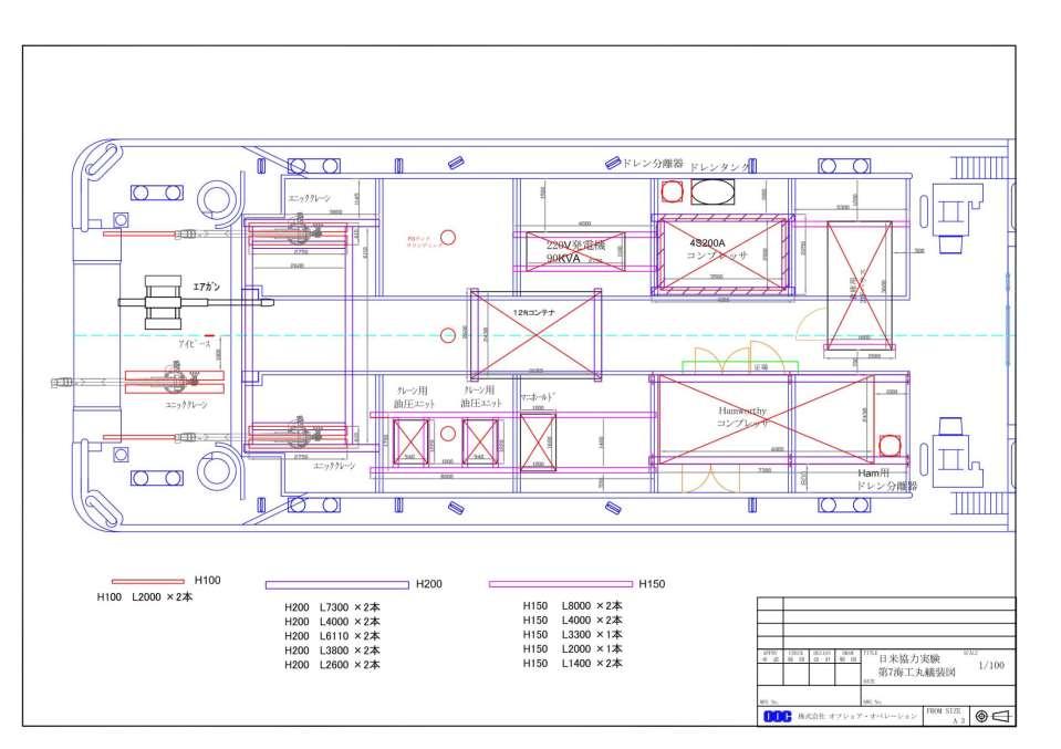
40 August, 2017: Kaiku Maru Equipment from USA (CA) ~40 days door to door Permanent Hamworthy compressor

41 August, 2017: Kaiku Maru


42 August 2017 Tomakomai Survey BEG & JGI New long streamer interconnects Cross cable on deck 30 minute deployment / recovery

43 Single-channel field record minimal processing 500 msec

44 Single-channel field record minimal processing 500 msec


45


46 Acquisition Challenges, but surmountable Receiver Positioning Accuracy; GPS method Leakage Signal Cable / Tri-point connection Custom sheave (3PS) Junction boxes: connectors Streamers Optimize Geometry Source tuning (Multiples)

47 Forward plans UT 2013 HR3D GoM dataset is publically available UTIG ASP Data Portal: Looking for research partners for a variety of HR3D +/- coring/em/other applications. Some funds and partners in hand. HR3D training cruise? New equipment? Japan second UT survey late Repeatability; direct ranging?

 3 Sercel GI airguns (210 cu.in.")
48 Forward plans UT Service Center established Broader use of equipment: academic, government, industry.?? Hire new staff to support program development. >$2M equipment investment 15 x 25 m solid Geoeel streamers 2 Baro #3 paravanes 4 winches: 2 tow, 1 data, 1 cross-cable Acquisition computer rack (2 SPSU + PC) 3 Sercel GI airguns (210 cu.in. + inserts) (lack streamer/umbilical spool) No ITAR restrictions 2 LMF Compressors From R/V Thompson, Univ. WA 300 scfm, 2175 psi ABS: All But Ship

49 QUESTIONS?
50 Technical Photo credit: Dallas Dunlap, BEG PROGRAM DEVELOPMENT Navigation / Positioning Equipment repair & replacement Platform / vessel Personnel Dedicated acquisition team Training Equipment function of intended investigation Streamer length: 25, 50, 200 m Source: mini-gi, GI, sparker, etc. Other Other
51 SELECT PUBLICATIONS Petersen, 2010, MPG, HR3D imaging of gas chimney structures in hydrated sediments of an Arctic sediment drift. Hustof, 2010, BR, 3D seismic analysis of the morphology and spatial distribution of chimneys beneath the Nyegga pockmark field, Norway. Moss, 2010, BR, 3D seismic expression of km-scale fluid escape pipes from offshore Namibia. Lippus, 2013, SAGEEP, High-resolution offshore 3D seismic geophysical studies of infrastructure geohazards (PG&E Diablo Canyon, California). Kluesner, 2016, Seismic attribute detection of faults and fluid pathways within an active strike-slip shear zone New insights from HR3D P-Cable seismic data along the Hosgri Rault, offshore California. Brookshire, 2015, UT, Applicability of ultra-high-resolution 3D seismic for hazard identification at midslope depths GoM. Meckel, 2016, Use if novel high-resolution 3D marine seismic data to evaluate Quaternary fluvial valley development and geologic controls on distribution of shallow gas anomalies, inner shelf, GoM.
52 APPLICATIONS Photo credit: Dallas Dunlap, BEG Quaternary Studies Sea level change Geohazard Natural systems: Fault, slump, etc. Drilling: NTL 2008-G05 (update soon via BOEM) Integrated JPC and CPT for 3D distribution of shallow physical properties. OBS/long 2D streamer options for velocity (fluids, shear data). Fluid Systems: Overburden characterization: Stratigraphy, faults, seals, secondary accumulations. Monitoring: 4D repeatability currently being explored (positioning critical) Acquisition (NRMS), Signal-to-distortion-ratio (SDR), time shifts Fluid effects; Saturation changes. Modern/Recent Reservoir Analog Studies: outcrop resolution Rio Grande Delta/Fan = Analog for Paleogene Wilcox Other GoM clastic settings; inner-shelf, slope, to deep water. Carbonates: RCRL, Caicos Gas Hydrates IODP Indian Ocean (NGHP-02); Flemings GoM DOE FOA.798 (2013) Alaminos Canyon, unfunded - but ideas transfer. CO2 Storage (CCS) Faults Shallow Gas Quaternary Stratigraphy...Coring

53


54
55 Deployment Acquisition ion (kg) ry Line (m) Payout Port Vane (m) Gross Tension (kg) Speed Starborad Paravane (m/min) Net Tension (kg) Payout Signal Cable (m) Payout Recovery Line (m) Speed Recovery Line (m/min) Net Tension (kg) Payout Signal Cable (m) Sheave Angle Payout Starborad Paravane (m) Sheave Angle Payout Starborad Paravane (m) Speed Signal Cable (m/min) Speed Starborad Paravane (m/min)


56
 [m] 3.0 3.5 4.0 4.")
57 SHORTENING FACTOR SHORTENING FACTOR Modeling Array Geometry Field data m 0.72 shortening Factor (184.71) m SHORTENING FACTOR VERSUS LAYBACK SHORTENING FACTOR VERSUS TOW SPEED Layback (Stern to Junction Boxes #12 & #13) [m] Tow Speed for Baseline Scenario [knots]

58 Statics Corrections GPS + acoustics
 Salt dynamics June 1 July 6, 2015 New Jersey Shelf Rutgers University (Greg Mountain) and UT-Austin (Austin &")
59 Recent news from North America 2014 SAFE-BAND, Phase 1 survey by NCS Subsea. Mid-shelf GoM (~1,000 m) Salt dynamics June 1 July 6, 2015 New Jersey Shelf Rutgers University (Greg Mountain) and UT-Austin (Austin & Fulthorpe). Brookshire et al., 2015, Underwater Technology
 Courtesy DownUnder Geosolutions Amplitude (db) @ ~12 db down, 23.5 Hz vs. 7.5 Hz (no deghost vs.")
60 2D Test Line ms, deghosted (w/ freq. enhancement) Courtesy DownUnder Geosolutions Amplitude ~12 db down, 23.5 Hz vs. 7.5 Hz (no deghost vs. deghost) deghosted raw no deghost deghosted w/ freq. enhancement 100 Hz 200 Hz 300 Hz

61 HR3D Reprocessed 3D
62 June 1 July 6, 2015 MGL1510 Geometry
63
64 p San Luis Pass
65 p High Island


66 Primary Observations Gas-bearing Sandstones Structurally complex area. Evidence of charge. Non-economic well history locally. Is this a good place to inject CO2? HR3-D seismic Near-surface faults Anomalies: chimney and shallow Quaternary stratigraphy HR3D ~ 1 mi Top of LM2 Reservoir Near-surface faults SW ~ 0.5 mi HR3D 66 NE

67

68

69
70

71


72 Meckel and Mulcahy, 2016, INTERPRETATION

73 Meckel and Mulcahy, 2016, INTERPRETATION


74

75
76 SELECT RESOURCES Petersen, 2010, Marine and Petroleum Geology, HR3D imaging of gas chimney structures in hydrated sediments of an Arctic sediment drift. Hustof, 2010, Basin Research, 3D seismic analysis of the morphology and spatial distribution of chimneys beneath the Nyegga pockmark field, Norway. Lippus, 2013, SAGEEP, High-resolution offshore 3D seismic geophysical studies of infrastructure geohazards (PG&E Diablo Canyon, California). Brookshire, 2015, Underwater Technology, Applicability of ultra-high-resolution 3D seismic for hazard identification at mid-slope depths GoM. Kluesner, 2016, Interpretation, Seismic attribute detection of faults and fluid pathways within an active strike-slip shear zone New insights from HR3D P-Cable seismic data along the Hosgri Rault, offshore California. USGS PC&MSC Meckel, 2016, Interpretation, Use if novel high-resolution 3D marine seismic data to evaluate Quaternary fluvial valley development and geologic controls on distribution of shallow gas anomalies, inner shelf, GoM.
77 Relative Methane Concentrations (Ongoing work of PhD Jacob Anderson) 20ms P23 P21 P20 P16 P15 P14 P13 P19 P11 P10 40ms (11.5m) amplitude anomaly P18 P17 P3 P7 P8 P9 100ms 500m P1,2 P4 P5 P6 UC1 Surface P22
P-Cable UHR3D Seismic What is it, and when is it better? Presented by: Brian Brookshire, NCS SubSea By Invitation of: SUT Houston's Offshore Site
 P-Cable UHR3D Seismic What is it, and when is it better? Presented by: Brian Brookshire, NCS SubSea By Invitation of: SUT Houston's Offshore Site Investigation and Geotechnics Committee Contents What is
Monitoring of CO2 Leakage Using High-Resolution 3D Seismic Data Examples from Snøhvit, Vestnesa Ridge and the Western Barents Sea
 Monitoring of CO2 Leakage Using High-Resolution 3D Seismic Data Examples from Snøhvit, Vestnesa Ridge and the Western Barents Sea Bellwald, B. 1, Waage, M. 2, Planke, S. 1,3,4, Lebedeva-Ivanova, N. 1,
Z046 Seismic Characteristics of Gas Migration Structures on the North Atlantic Margin Imaged by High-resolution 3D Seismic
 Z046 Seismic Characteristics of Gas Migration Structures on the North Atlantic Margin Imaged by High-resolution 3D Seismic O.K. Eriksen* (P-Cable 3D Seismic), C. Berndt (IFM-GEOMAR), S. Buenz (University
Towed Streamer EM Integrated interpretation for accurate characterization of the sub-surface. PETEX, Tuesday 15th of November 2016
 Towed Streamer EM Integrated interpretation for accurate characterization of the sub-surface. PETEX, Tuesday 15th of November 2016 Joshua May Sales and Marketing Manager Agenda Introduction to Towed Streamer
SONGS Seismic Research Projects
 SONGS Seismic Research Projects Energy Division Independent Peer Review Group September 21, 2012 Agenda Background Overview Project Support Permits, Approvals, and Reviews Schedule Use of Advanced Technologies
Gulf of México Mapping NATCARB Atlas
 Gulf of México Mapping NATCARB Atlas Presenter: Ramón Treviño Gulf Coast Carbon Center University of Texas at Austin, Bureau of Economic Geology NACAP Cuernavaca, Morelos, México March 9, 2010 Acknowledgements
FloatSeis Technologies for Ultra-Deep Imaging Seismic Surveys
 FloatSeis Technologies for Ultra-Deep Imaging Seismic Surveys 25 th January, 2018 Aleksandr Nikitin a.nikitin@gwl-geo.com Geology Without Limits Overview 2011-2016 GWL Acquired over 43000 km 2D seismic
IODP Science Evaluation Panel: Guidelines and Rationale for Site Characterization Data (Revised: August 2013)
") Site Characterization Data Guidelines IODP Science Evaluation Panel: Guidelines and Rationale for Site Characterization Data (Revised: August 2013) This document outlines the method and rationale for data
Site Characterization Data Guidelines IODP Science Evaluation Panel: Guidelines and Rationale for Site Characterization Data (Revised: August 2013) This document outlines the method and rationale for data
Constraining fluid flow processes and the physical properties of sediments relevant to CCS
 Constraining fluid flow processes and the physical properties of sediments relevant to CCS Jonathan M. Bull University of Southampton National Oceanography Centre Southampton Acknowledgements: Ben Callow,
Marine Geophysical Methods: What Can and Cannot Be Done to Iden8fy Hazards to Dredging & Marine Construc8on
 Marine Geophysical Methods: What Can and Cannot Be Done to Iden8fy Hazards to Dredging & Marine Construc8on Marine Geophysics Sham or Savior? Seen alternatively as the silver bullet or snake oil, marine
BERG-HUGHES CENTER FOR PETROLEUM AND SEDIMENTARY SYSTEMS. Department of Geology and Geophysics College of Geosciences
 BERG-HUGHES CENTER FOR PETROLEUM AND SEDIMENTARY SYSTEMS Department of Geology and Geophysics College of Geosciences MISSION Integrate geoscience, engineering and other disciplines to collaborate with
Detailed structure of buried glacial landforms revealed by high-resolution 3D seismic data in the SW Barents Sea
 Detailed structure of buried glacial landforms revealed by high-resolution 3D seismic data in the SW Barents Sea Benjamin Bellwald 1, Sverre Planke 1,2, Stéphane Polteau 1, Nina Lebedova-Ivanova 1, Amer
Global Opportunities for Offshore CCS : Assessing Offshore Storage on Continental Shelves
 Global Opportunities for Offshore CCS : Assessing Offshore Storage on Continental Shelves International Workshop on Offshore Geological CO 2 Storage Austin, Texas April 19 20, 2016 Dr. Tip Meckel, Research
Offshore Geosequestration Potential in the Gulf of Mexico. Carbon Sequestration Opportunities in the North Sea Conference March, 2010
 Offshore Geosequestration Potential in the Gulf of Mexico Presenter: Ramón Treviño Gulf Coast Carbon Center Bureau of Economic Geology University of Texas at Austin, Carbon Sequestration Opportunities
Vertical Hydrocarbon Migration at the Nigerian Continental Slope: Applications of Seismic Mapping Techniques.
 ROAR HEGGLAND, Statoil ASA, N-4035 Stavanger, Norway Vertical Hydrocarbon Migration at the Nigerian Continental Slope: Applications of Seismic Mapping Techniques. Summary By the use of 3D seismic data,
Gas Hydrate BSR and Possible Fluid Migration in the Nankai Accretionary Prism off Muroto
 Gas Hydrate BSR and Possible Fluid Migration in the Nankai Accretionary Prism off Muroto Sumito Morita 1), Yasuyuki Nakamura 2), Shin ichi Kuramoto 3), Nathan Bangs 4) and Asahiko Taira 3) 1) Geological
Offshore Operations and Project Execution Geophysical Site Surveys
 Offshore Operations and Project Execution Geophysical Site Surveys Chris Almond Senior Geophysicist Fugro Survey Limited 22/04/2015 Presentation Summary: Office-based Personnel Project Awarded Pre Offshore
Marine Heat Flow Measurements Information Brochure
 Marine Heat Flow Measurements Information Brochure 5 1 2 3 4 5 5 6 7 8 5 9 10 11 12 13 14 5 15 16 17 18 19 20 21 5 22 0 200 400 600 800 1000 1200 1400 1600 Time (s) What is the use of heat flow measurements?
CO2 Storage- Project list
 a) NGI involvement with CO 2 storage field sites, pilots and demos 1. In Salah CO2 storage In Salah is located in Krechba, central Algeria. Injection of CO 2 started in 2004 and halted in 2011. A total
IOGP Hazard Survey Guidelines and Technical Notes. Andy W Hill, BP America, March 2016
 IOGP Hazard Survey Guidelines and Technical Notes Andy W Hill, BP America, March 2016 Summary Background to the IOGP Guidelines for the Conduct of Offshore Drilling Hazard Site Surveys (DHSS) Objective
PG&E OFFSHORE CENTRAL COASTAL CALIFORNIA SEISMIC IMAGING PROJECT
 PG&E OFFSHORE CENTRAL COASTAL CALIFORNIA SEISMIC IMAGING PROJECT Public Scoping Meeting California State Lands Commission July 21, 2011 Project Area Project Commitments Assessment of the Hosgri, Shoreline,
PETE/GEOS 445/645 Petroleum Geology 3 credits
 PETE/GEOS 445/645 Petroleum Geology 3 credits Tuesday, Thursday 3:40-5:10 Reichardt 233 Hydrocarbons fuel today s economy, but remain a relatively rare natural resource. The objective of this course is
BAUER MeBo Sea Bed Drill Rig
 BAUER MeBo Sea Bed Drill Rig Spotlights BAUER Maritime Experiences 1993 Diamond deposit exploration with a BC cutter in water depth of 160 m (South Africa) Atlantic Ocean 2005 Drilling inside of a monopile
SEISMIC CAMPAIGN SIMON STEVIN (Cruise No ) 10-4 OCTOBER 2016
 10-4 OCTOBER 2016") IWT SBO PROJECT 120003 SEARCH Archaeological heritage in the North Sea Development of an efficient assessment methodology and approach towards a sustainable management policy and legal framework in Belgium.
IWT SBO PROJECT 120003 SEARCH Archaeological heritage in the North Sea Development of an efficient assessment methodology and approach towards a sustainable management policy and legal framework in Belgium.
Indonesia Frontier Basin SUNDA (SU-08) NON-EXCLUSIVE 2-D SURVEY 3084km
 NON-EXCLUSIVE 2-D SURVEY 3084km") Indonesia Frontier Basin SUNDA (SU-08) NON-EXCLUSIVE 2-D SURVEY 3084km SEISMIC ACQUISITION PARAMETERS Acquisition Date: January - March 2008 Vessel: M/V Osprey Explorer Shooting Orientation: Strike-Dip
Indonesia Frontier Basin SUNDA (SU-08) NON-EXCLUSIVE 2-D SURVEY 3084km SEISMIC ACQUISITION PARAMETERS Acquisition Date: January - March 2008 Vessel: M/V Osprey Explorer Shooting Orientation: Strike-Dip
Comparative Study of Multi-channel and High Resolution Seismic data for Gas Hydrate Exploration in Krishna-Godavari basin, Bay of Bengal.
 Comparative Study of Multi-channel and High Resolution Seismic data for Gas Hydrate Exploration in Krishna-Godavari basin, Bay of Bengal. Pawan Dewangan Gas Hydrate Group National Institute of Oceanography,
Yev Kontar. Illinois State Geological Survey, University of Illinois at Urbana-Champaign
 Addressing Caribbean Geophysical Hazards through the Continuously Operating Caribbean GPS Observational Network (COCONet) and International Ocean Drilling Program (IODP) Yev Kontar Illinois State Geological
Deep-Water Reservoir Potential in Frontier Basins Offshore Namibia Using Broadband 3D Seismic
 Deep-Water Reservoir Potential in Frontier Basins Offshore Namibia Using Broadband 3D Seismic E. Polyaeva* (Petroleum Geo-Services), I. Thomas (Chariot Oil and Gas), C. Reiser (Petroleum Geo-Services),
Multicomponent seismic survey at Spring Coulee: a data repeatability study
 Multicomponent repeatability Multicomponent seismic survey at Spring Coulee: a data repeatability study Don Lawton, Peter Gagliardi, Malcolm Bertram, Hanxing Lu, Kevin Hall, Joanna Cooper, Eric Gallant,
Hydrofest The Hydrographic Society in Scotland
 Hydrofest 2017 The Hydrographic Society in Scotland Offshore Survey in the Oil and Gas Industry Hydrofest 2017 Chris Leaf Head Offshore Surveys Shell Projects and Technology, Europe Presentation Overview
Hague and London Oil Plc
 Hague and London Oil Plc Exploiting Shallow Gas Offshore Netherlands De-Gassing Shallow Hazards or De-Risking Shallow Gas November 2016 The Shallow Gas Play can be Summarized as Schematic evolution of
PETROLEUM GEOSCIENCES GEOLOGY OR GEOPHYSICS MAJOR
 PETROLEUM GEOSCIENCES GEOLOGY OR GEOPHYSICS MAJOR APPLIED GRADUATE STUDIES Geology Geophysics GEO1 Introduction to the petroleum geosciences GEO2 Seismic methods GEO3 Multi-scale geological analysis GEO4
Imaging Deep into the Gulf of
 TECHNOLOGY EXPLAINED Imaging Deep into the Gulf of Houston Houston The Gulf of Mexico as viewed from space. This Mediterraneantype sea is located at the southeastern corner of North America. It covers
James A. Austin, Jr. phone: (512) fax: (512)
 fax: (512)") High-Resolution Seismic Surveying for Neogene-Quaternary Sequence Stratigraphy, Northern California Continental Shelf and Upper Slope, in Support of STRATAFORM Craig S. Fulthorpe University of Texas Institute
High-Resolution Seismic Surveying for Neogene-Quaternary Sequence Stratigraphy, Northern California Continental Shelf and Upper Slope, in Support of STRATAFORM Craig S. Fulthorpe University of Texas Institute
Tutorial on Methane Hydrate. Presented by Ad Hoc Group on Methane Hydrate Research March 24, 2004
 Tutorial on Methane Hydrate Presented by Ad Hoc Group on Methane Hydrate Research March 24, 2004 Tutorial on Methane Hydrate What is it and how is it formed? Where is it found? How much may exist? Multi-National
OFFSHORE SURVEY IN THE OIL & GAS INDUSTRY WHAT S THAT ALL ABOUT? Ian Douglas Head, Offshore Surveys, Shell Projects & Technology Europe
 OFFSHORE SURVEY IN THE OIL & GAS INDUSTRY WHAT S THAT ALL ABOUT? Ian Douglas Head, Offshore Surveys, Shell Projects & Technology Europe Hydrofest 2014 13 March 2014 1 Why Position Matters The Exploration
COVER STORY LUKE TWIGGER, CGG, UK, EXAMINES RECENT ADVANCES IN SEISMIC TECHNOLOGY THAT REDUCE SUBSALT RISK.
 COVER STORY LUKE TWIGGER, CGG, UK, EXAMINES RECENT ADVANCES IN SEISMIC TECHNOLOGY THAT REDUCE SUBSALT RISK. O il and gas exploration, especially in areas of complex geology such as salt provinces, is a
Full-waveform inversion application in different geological settings Denes Vigh*, Jerry Kapoor and Hongyan Li, WesternGeco
 Full-waveform inversion application in different geological settings Denes Vigh*, Jerry Kapoor and Hongyan Li, WesternGeco Summary After the synthetic data inversion examples, real 3D data sets have been
Tu 23 A12 Multi-frequency Seafloor Characterization Using Seismic Sources of Opportunity
 Tu 23 A12 Multi-frequency Seafloor Characterization Using Seismic Sources of Opportunity M.N. Banda* (University of Bath/Seiche Ltd), Ph. Blondel (University of Bath), M. Burnett (Seiche Ltd), R. Wyatt
Economic Geology Unconventional Energy Research
 Bureau of Economic Geology Unconventional Energy Research Overview for CEE meeting December, 2011 QAd2349x BUREAU OF ECONOMIC GEOLOGY Oldest research unit of The University of Texas at Austin Geological
Identified a possible new offset location where the customer is currently exploring drill options.
 GroundMetrics was hired to conduct a Full-Field Resistivity Survey for an oil and gas producer that needed to make crucial decisions to drive profitability at the location. The results saved them hundreds
Geosciences Career Pathways (Including Alternative Energy)
") Geosciences Career Pathways (Including Alternative Energy) Shale Carbonates Clastics Unconventionals Geology Characterization and Production Properties of Gas Shales Geomechanics in International Shale
Geosciences Career Pathways (Including Alternative Energy) Shale Carbonates Clastics Unconventionals Geology Characterization and Production Properties of Gas Shales Geomechanics in International Shale
Introduction to Acoustic Remote Sensing and Seafloor Mapping (AE4-E13) May 19, 2010
 May 19, 2010") Introduction to Acoustic Remote Sensing and Seafloor Mapping (AE4-E13) May 19, 2010 1 Delft Vermelding Institute onderdeel of Earth organisatie Observation and Space Systems Why Acoustic Remote Sensing?
Introduction to Acoustic Remote Sensing and Seafloor Mapping (AE4-E13) May 19, 2010 1 Delft Vermelding Institute onderdeel of Earth organisatie Observation and Space Systems Why Acoustic Remote Sensing?
An Overview of the Tapia Canyon Field Static Geocellular Model and Simulation Study
 An Overview of the Tapia Canyon Field Static Geocellular Model and Simulation Study Prepared for Sefton Resources Inc. Jennifer Dunn, Chief Geologist Petrel Robertson Consulting Ltd. Outline Background
SUMMARY OF SCIENTIFIC STUDY RESULTS SUPPORTING THE FEDERAL POSITION ON MC-20 SITE
 SUMMARY OF SCIENTIFIC STUDY RESULTS SUPPORTING THE FEDERAL POSITION ON MC-20 SITE 10-23-2018 The united Federal position on the MC-20 site is as follows, with summaries of the studies relied upon to reach
Last Time. GY 305: Geophysics. Seismology (Marine Surveys) Seismology. Seismology. Other Seismic Techniques UNIVERSITY OF SOUTH ALABAMA
 Seismology. Seismology. Other Seismic Techniques UNIVERSITY OF SOUTH ALABAMA") UNIVERSITY OF SOUTH ALABAMA Last Time GY 305: Geophysics Lecture 12: Introduction to (resolution versus penetration) Techniques (marine versus terrestrial) (Marine Surveys) http://www.glossary.oilfield.slb.com/displayimage.cfm?id=236
UNIVERSITY OF SOUTH ALABAMA Last Time GY 305: Geophysics Lecture 12: Introduction to (resolution versus penetration) Techniques (marine versus terrestrial) (Marine Surveys) http://www.glossary.oilfield.slb.com/displayimage.cfm?id=236
Geophysical Site Surveys
 Geophysical Site Surveys Simon Oakley Geoscience Team Leader Fugro Survey Limited 16/04/2014 Contents Menu Introduction Section 1 - Geophysical Site Surveys - Seabed Bathymetry - Shallow Geology - Seabed
Hydrocarbon Trap Classification Based on Associated Gas Chimneys
 Chapter 14 Hydrocarbon Trap Classification Based on Associated Gas Chimneys Roar Heggland 1 Abstract Oil seeps, shallow gas, and surface features such as seabed pockmarks and mud volcanoes are historically
Developments in Storage and Monitoring for CCUS
 Developments in Storage and Monitoring for CCUS Steve Whittaker Director Energy Research & Development Illinois State Geological Survey 4 th Beijing International Forum on Carbon Capture, Utilization and
Training the Next Generation of Geoscientists to Solve Realworld Environmental Problems using Advanced Techniques: Year Two Report
 Illinois State Geological Survey 615 E. Peabody Dr. Champaign, IL 61820 Training the Next Generation of Geoscientists to Solve Realworld Environmental Problems using Advanced Techniques: Year Two Report
Peter Polito 27 July 2012 BEG Summer Seminar Series
 Peter Polito 27 July 2012 BEG Summer Seminar Series Motivation Working with IODP What is the T2PMDHDSERSMFTM anyway? the old and the new four parts Out to sea and life on the JR Testing The next steps
High Resolution Geophysics: A Better View of the Subsurface. By John Jansen, P.G., Ph.D., Aquifer Science and Technology
 High Resolution Geophysics: A Better View of the Subsurface By John Jansen, P.G., Ph.D., Aquifer Science and Technology Geologist Use Only Part of the Information Available To Them Most Geologist rely
Diablo Canyon SSHAC Level 3 Study
 1 Diablo Canyon SSHAC Level 3 Study Workshop 1 Summary of SSC Hazard Significant Issues and Data Needed William Lettis November 29 to December 1, 2011 PG&E DCPP SSHAC Study 2 Hosgri Hosgri Location Hosgri
Source Sink Pipeline
 An Overview of Carbon Storage presented by Robert J. Finley Advanced Energy Technology Initiative Illinois State Geological Survey University of Illinois USA IEA Summer School Longyearbyen, Norway August,
June 13-July 8, Astoria-Astoria
 MGL1211: Cascadia Basin Ridge to Trench June 13-July 8, Astoria-Astoria Motivation 1. How does the JdF plate evolve from ridge to trench and is there significant hydration of the crust and upper mantle
Short Cruise Report R/V MARIA S. MERIAN MSM34/2
 Dr. Joerg Bialas GEOMAR Helmholtz-Centre fpr Marine Sciences Kiel Wischhofstr. 1-3 24148 Kiel Tel.: +49 (0)431 600 2329 Fax: +49 (0)431 600 2922 email: jbialals@geomar.de Short Cruise Report R/V MARIA
7.0 Project Reports 7.1 Geophysical Mapping of Submarine Environments
 7.0 Project Reports 7.1 Geophysical Mapping of Submarine Environments Suzanne Carbotte, Robin Bell, Roger Flood 7.1.1 METHODS In April 2000 we deployed the R/V Onrust, operated by MSRC at SUNY Stony Brook,
A 3D seismic survey for mapping shallow targets
 A 3D seismic survey for mapping shallow targets Don C. Lawton, Robert R. Stewart, and Malcolm B. Bertram Department of Geoscience University of Calgary 2500 University Drive N.W. Calgary, Alberta T2N 1N4
Ocean bottom seismographs GNS for active and passive seismic observation for the depth range from 0 to 7000 meters
 www.geonodalsolutions.com Ocean bottom seismographs GNS for active and passive seismic observation for the depth range from 0 to 7000 meters Self popup Ocean bottom seismic recorders key operational features
Seismic applications in coalbed methane exploration and development
 Seismic applications in coalbed methane exploration and development Sarah E. Richardson*, Dr. Don C. Lawton and Dr. Gary F. Margrave Department of Geology and Geophysics and CREWES, University of Calgary
CO2 storage modelling and capacity estimates for the Trøndelag Platform a basin modelling approach
 CO2 storage modelling and capacity estimates for the Trøndelag Platform a basin modelling approach Ane E. Lothe, Benjamin U. Emmel & Per Bergmo NORDICCS Conference Contribution D 6.1.1407 (4) August 2014
Seafloor Mapping and Research Activities
 Seafloor Mapping and Research Activities Marco D Emidio Mississippi Mineral Resources Institute Advisory Board Meeting Jackson, MS February 12, 2015 Outline 1. Define your Goal/Target What do you want
Exploration research at SINTEF Petroleum
 Joining Forces 2016, Stavanger 2 nd and 3 rd of February 2016 Exploration research at SINTEF Petroleum Ane Lothe Research Manager, Basin Modelling Group Technology for a better society 1 Overview Short
National Marine Sanctuary Program
 National Marine Sanctuary Program NMSP/USGS Joint Seabed Mapping Initiative: September 2004 AA National Ocean Service National Marine Sanctuaries Interim Report September 2004 Background: Since 2002,
3. UNDERWAY GEOPHYSICS 1
 Sawyer, D.S., Whitmarsh, R.B., Klaus, A., et al., 1994 Proceedings of the Ocean Drilling Program, Initial Reports, Vol. 149 3. UNDERWAY GEOPHYSICS 1 Shipboard Scientific Party 2 EQUIPMENT AND METHODS Navigation
DE-FG26-06NT Line 120. Line ft ft
 A B 1240 ms ms PreSTM-RMOTC 1212 1212 ms ms PreSTM-UH PreSTM-UH Figure 13. Coherence time slices near top granite basement extracted from UH processed and commercially processed (RMOTC data) prestack time
Gas Hydrate as a Resource - Statoil s Hydrate Initiative
 Gas Hydrate as a Resource - Statoil s Hydrate Initiative Thomas Reichel & Jarle Husebø Exploration Global New Ventures / R&D Explore Unconventionals 1 - Outline Gas hydrate occurances & resource potential
Chapter Overview. Bathymetry. Measuring Bathymetry. Measuring Bathymetry
 CHAPTER 3 Marine Provinces Chapter Overview The study of bathymetry determines ocean depths and ocean floor topography. Echo sounding and satellites are efficient bathymetric tools. Most ocean floor features
3D time-lapse seismic monitoring of the pilot CO 2 storage site at Ketzin, Germany
 3D time-lapse seismic monitoring of the pilot CO 2 storage site at Ketzin, Germany Reflections on Seismic Acquisition, Utrecht, Feb 2017 Monika Ivandic, Christopher Juhlin and Fengjiao Zhang Department
An Open Air Museum. Success breeds Success. Depth Imaging; Microseismics; Dip analysis. The King of Giant Fields WESTERN NEWFOUNDLAND:
 VOL. 7, NO. 4 2010 GEOSCIENCE & TECHNOLOGY EXPLAINED GEO EXPRO VOL. 7, NO. 4 2010 Success breeds Success geoexpro.com Country Profile: Senegal Ocean Bottom Node Seismic WESTERN NEWFOUNDLAND: An Open Air
Submarine Debris flow Project Proposal to Force August 2018/v1.02
 Submarine Debris flow Project Proposal to Force August 2018/v1.02 Summary The main objective of the Submarine Debris Flow study is to implement the concept of debris flow in the MassFlow3DÔ code as an
2. Identify other PIs associated with the cruise: 3. Identify the at-sea Chief Scientist: Charles Langmuir
 Pre-Cruise Meeting April 17, 2014 AT26-19, Charles Langmuir, Aug 28 Sept 11, 2014. RV Atlantis with OSU Coring Facility General Program Overview: 1. Scientific Objectives: Our aim is to obtain as many
GEOPHYSICAL SURVEYS: What are Seismic Surveys and How are They Done?
 GEOPHYSICAL SURVEYS: What are Seismic Surveys and How are They Done? Marine Geophysical Exploration Purpose Image the subsurface Evaluate the acreage Identify potential hydrocarbon accumulations Reducing
Bathymetry Measures the vertical distance from the ocean surface to mountains, valleys, plains, and other sea floor features
 1 2 3 4 5 6 7 8 9 10 11 CHAPTER 3 Marine Provinces Chapter Overview The study of bathymetry determines ocean depths and ocean floor topography. Echo sounding and satellites are efficient bathymetric tools.
Appendix H High Resolution Marine Seismic Reflection Surveys
 Appendix H High Resolution Marine Seismic Reflection Surveys Shoreline Fault Zone Report, Appendix H Seis. Reflection Page H-1 of 8 Introduction Single-channel seismic-reflection data were acquired in
B048 Seabed Properties Derived from Ambient Noise
 B048 Seabed Properties Derived from Ambient Noise E. Muyzert* (Schlumberger Cambridge Research) SUMMARY An extensive study of low-frequency ambient noise wavefields in the seabed has resulted in a new
Engineering in Support of Transformative Science
 Engineering in Support of Transformative Science Scientific Ocean Drilling of Mid-Ocean Ridge and Ridge-Flank Setting Workshop August 27, 2009 Austin, Texas Greg Myers IODP-MI Outline o Main engineering
Modeling and interpretation of CSEM data from Bressay, Bentley and Kraken area of East Shetland Platform, North Sea
 from Bressay, Bentley and Kraken area of East Shetland Platform, North Sea Anwar Bhuiyan*, Rune Sakariassen, Øystein Hallanger and Allan McKay, PGS Summary The heavy oil reservoirs of the Bentley, Bressay
Downloaded 11/20/12 to Redistribution subject to SEG license or copyright; see Terms of Use at
 AVO crossplot analysis in unconsolidated sediments containing gas hydrate and free gas: Green Canyon 955, Gulf of Mexico Zijian Zhang* 1, Daniel R. McConnell 1, De-hua Han 2 1 Fugro GeoConsulting, Inc.,
Tu G Mapping of Sand Injectites from Colourprocessed Multimeasurement Seismic Data
 Tu G107 08 Mapping of Sand Injectites from Colourprocessed Multimeasurement Seismic Data A. Laake* (Schlumberger) SUMMARY In a PSDM data set from the Central North Sea we found sand injectite structures
Multicomponent seismic surveys at Sibbald Flats, Alberta
 Multicomponent seismic surveys at Sibbald Flats, Alberta Robert R. Stewart and Don C. Lawton ABSTRACT We conducted a 3C seismic survey, using vibrators, over a 5 km line in the Sibbald Flats area some
The Seafloor deformation and well bore stability monitoring during gas production in unconsolidated reservoirs
 The Seafloor deformation and well bore stability monitoring during gas production in unconsolidated reservoirs *Joo Yong Lee, Jong-Hwa Chun and Se Joon Kim Petroleum & Marine Research Division, KIGAM,
region includes nine states and four provinces, covering over 1.4 million square miles. The PCOR Partnership
 Overview of Phase II PCOR Partnership MVA Activities IEAGHG Monitoring Network Meeting Natchez, MS May 6-8, 2010 Steven A. Smith, Energy & Environmental Research Center The Plains CO 2 Reduction (PCOR)
Pluto 1.5 2D ELASTIC MODEL FOR WAVEFIELD INVESTIGATIONS OF SUBSALT OBJECTIVES, DEEP WATER GULF OF MEXICO*
 Pluto 1.5 2D ELASTIC MODEL FOR WAVEFIELD INVESTIGATIONS OF SUBSALT OBJECTIVES, DEEP WATER GULF OF MEXICO* *This paper has been submitted to the EAGE for presentation at the June 2001 EAGE meeting. SUMMARY
Hydrocarbon Volumetric Analysis Using Seismic and Borehole Data over Umoru Field, Niger Delta-Nigeria
 International Journal of Geosciences, 2011, 2, 179-183 doi:10.4236/ijg.2011.22019 Published Online May 2011 (http://www.scirp.org/journal/ijg) Hydrocarbon Volumetric Analysis Using Seismic and Borehole
Seismoelectric Ground-flow DC-4500 Locator
 Seismoelectric Ground-flow DC-4500 Locator Introduction The seismoelectric survey is a new technology combined the electro kinetic potential method and geophysical technology. It is applied directly to
SEISMIC STRUCTURE, GAS-HYDRATE CONCENTRATIONS, AND SLUMPING ALONG THE IODP X311 TRANSECT ON THE N. CASCADIA MARGIN
 Proceedings of the 6th International Conference on Gas Hydrates (ICGH 2008), Vancouver, British Columbia, CANADA, July 6-10, 2008. SEISMIC STRUCTURE, GAS-HYDRATE CONCENTRATIONS, AND SLUMPING ALONG THE
Block 43B - Onshore Oman
 Block 43B - Onshore Oman SUMMARY Block 43B is an 11,967 km 2 area located along the coastal area of Oman north of the Hajar Mountains. This is an unexplored region, both geographically and stratigraphically.
Geologic CO 2 Storage Options for California
 Geologic CO 2 Storage Options for California Larry Myer WESTCARB Technical Director California Energy Commission lrmyer@lbl.gov Carbon Capture & Sequestration Public Workshops February 13 14, 2008 Outline
We A Multi-Measurement Integration Case Study from West Loppa Area in the Barents Sea
 We-16-12 A Multi-Measurement ntegration Case Study from West Loppa Area in the Barents Sea. Guerra* (WesternGeco), F. Ceci (WesternGeco), A. Lovatini (WesternGeco), F. Miotti (WesternGeco), G. Milne (WesternGeco),
Charleston to Woods Hole R/V Armstrong Transit: Atlantic Margin Upper Slope Fluid Flow Features, Seafloor and Water Column Surveys
 Charleston to Woods Hole R/V Armstrong Transit: Atlantic Margin Upper Slope Fluid Flow Features, Seafloor and Water Column Surveys Contacts: Carolyn Ruppel (US Geological Survey, cruppel@usgs.gov, 508-457-2339)
Time-Lapse Seismic: A Geophysicist s Perspective. Rob Staples Shell E & P Europe. SPE / EAGE workshop Copenhagen, March 2004
 Time-Lapse Seismic: A Geophysicist s Perspective Rob Staples Shell E & P Europe SPE / EAGE workshop Copenhagen, March 2004 1. What do we observe? 2. Noise and detectability 3. Resolution, scale, interference
3-D seismic data acquisition, with special reference to recovery programme, in Contai area, Bengal Basin, India
 P - 352 3-D seismic data acquisition, with special reference to recovery programme, in Contai area, Bengal Basin, India *A. K. Roy, S. Shanmugaswamy, T. R. Verma,Y.P. Babu, & B. K. Sharma, ONGC, akroy_ongc@yahoo.co.in
Downloaded 09/16/16 to Redistribution subject to SEG license or copyright; see Terms of Use at
 Ehsan Zabihi Naeini*, Ikon Science & Russell Exley, Summit Exploration & Production Ltd Summary Quantitative interpretation (QI) is an important part of successful Central North Sea exploration, appraisal
Improved Exploration, Appraisal and Production Monitoring with Multi-Transient EM Solutions
 Improved Exploration, Appraisal and Production Monitoring with Multi-Transient EM Solutions Folke Engelmark* PGS Multi-Transient EM, Asia-Pacific, Singapore folke.engelmark@pgs.com Summary Successful as
ENVIRONMENTAL GEOSCIENCE UNIFORM SYLLABUS
 ENVIRONMENTAL GEOSCIENCE UNIFORM SYLLABUS The Association of Professional Engineers and Geoscientists of the Province of British Columbia Note: 1. This Syllabus May Be Subject To Change 2. These Courses
Small area of the ocean that is partially surrounded by land. The Ocean Basins. Three Major Oceans. Three Major Oceans. What is a SEA?
 The Ocean Basins How Deep is the Ocean? 1 2 Three Major Oceans Three Major Oceans Pacific Atlantic the shallowest ocean (3.3km average depth) Indian second shallowest ocean (3.8km average depth) Pacific
Exploration, Drilling & Production
 Nontechnical Guide to PETMOLEUM Geology, Exploration, Drilling & Production Third Edition Norman J. Hyne, Ph.D. Contents Preface *i Introduction 1 The Nature of Gas and Oil 1 Petroleum 1 The Chemistry
Geological Expression A New Approach to Volume Interpretation. Gaynor Paton, ffa
 Geological Expression A New Approach to Volume Interpretation Gaynor Paton, ffa The Value of Data Frontier exploration High exploration costs Uncertain returns $$$ Mature basins Marginal Returns Geological