PG&E OFFSHORE CENTRAL COASTAL CALIFORNIA SEISMIC IMAGING PROJECT
|
|
|
- Stanley Pierce Wilkins
- 5 years ago
- Views:
Transcription

1 PG&E OFFSHORE CENTRAL COASTAL CALIFORNIA SEISMIC IMAGING PROJECT Public Scoping Meeting California State Lands Commission July 21, 2011

2 Project Area
3 Project Commitments Assessment of the Hosgri, Shoreline, and other faults in the vicinity of Diablo Canyon Power Plant (DCPP) California Public Utilities Commission Fault survey using the following methods Offshore three-dimensional (3D) high energy survey Onshore two-dimensional (2D) high energy scope near coast Seafloor geophones nearshore in low water levels
4 Project Objectives Obtain improved deep (>1 km [>0.6 mi]) imaging of the Hosgri and Shoreline fault zones to better define fault geometry - in the vicinity of the DCPP - at the intersection of the Hosgri and Shoreline fault zones near Point Buchon - at the intersection of the San Simeon and Hosgri fault zones near Point Estero Expand regional seismic database

5 Offshore Seismic Imaging Survey Cambria to Point San Luis in water up to 1,400 ft. Specialized survey vessel approximately 240 ft in length Vessel-towed individual or multiple strings of tuned air guns with a volume of 3,300 in 3 Vessel-towed hydrophone streamer array of 3 to 5 miles length Additional scout and support vessels

6 Towed Air Gun Array and Acoustic Streamers

7 Seismic Survey Process
 Southern Survey Area 765 miles 30 day survey duration")
8 Survey Track Lines Northern Survey Area 547 miles 22 day survey duration (24/7) Southern Survey Area 765 miles 30 day survey duration (24/7)
 Includes both offshore and onshore sound")
9 Nearshore Seismic Imaging Survey Nearshore areas too shallow for larger survey vessels Seafloor geophones will be placed by smaller vessel Geophone strings to -300 ft water depth (approximately 3 miles offshore) Includes both offshore and onshore sound sources


10 Geophone Lines in Southern Survey Area

11 Pacific Gas and Electric Company Onshore Source and Receiver Lines Receiver Lines Only


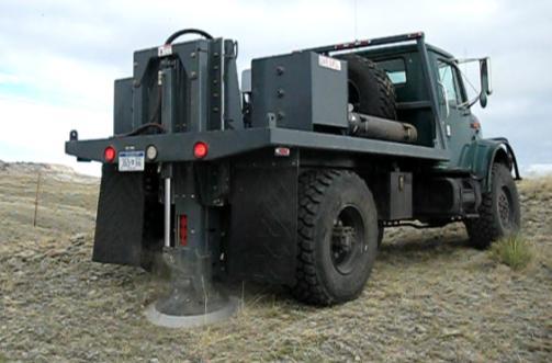
12 Source and Receiver Equipment


13 Survey Schedule and Duration Proposed survey to be conducted September through December 2012 Estimated work period is 3 months with 24 hour operations (6 months if daylight only operations)
14 Offshore Survey Procedures Marine Wildlife Contingency Plan approved by NOAA Fisheries Pre-activity aerial surveys and equipment noise level testing Established Safety and Exclusion Zones Ramp-up of all air guns Marine mammal monitors onboard all survey vessels Scheduled to coincide with low marine mammal activity (late fall/early winter) Notification to mariners and commercial fishers Avoidance of sensitive resource areas to extent feasible
15 Anticipated Agency Approvals California State Lands Commission Geophysical Permit (Seismic Survey) California Environmental Quality Act (CEQA) Lead Agency NOAA Fisheries Incidental Harassment Authorization (IHA)/Endangered Species Act (ESA) Consultation Army Corps of Engineers Section 10/404 Certification for marine operations National Environmental Policy Act (NEPA) Lead California Coastal Commission Coastal Development Permit (CDP)/Federal Consistency County of San Luis Obispo CDP for onshore sources/receiver line and Encroachment Permit U.S. Fish and Wildlife Service (FWS) - ESA Consultation California Department of Fish & Game CESA Permits/MPA Authorization California Dept. of Parks and Recreation Encroachment Permit Regional Water Quality Control Board Section 401 Certification U.S. Coast Guard Notice to Mariners
SONGS Seismic Research Projects
 SONGS Seismic Research Projects Energy Division Independent Peer Review Group September 21, 2012 Agenda Background Overview Project Support Permits, Approvals, and Reviews Schedule Use of Advanced Technologies
8.0 SUMMARY AND CONCLUSIONS
 8.0 SUMMARY AND CONCLUSIONS In November 2008, Pacific Gas and Electric (PG&E) informed the U.S. Nuclear Regulatory Commission (NRC) that preliminary results from the Diablo Canyon Power Plant (DCPP) Long
GEOPHYSICAL SURVEYS: What are Seismic Surveys and How are They Done?
 GEOPHYSICAL SURVEYS: What are Seismic Surveys and How are They Done? Marine Geophysical Exploration Purpose Image the subsurface Evaluate the acreage Identify potential hydrocarbon accumulations Reducing
Appendix H High Resolution Marine Seismic Reflection Surveys
 Appendix H High Resolution Marine Seismic Reflection Surveys Shoreline Fault Zone Report, Appendix H Seis. Reflection Page H-1 of 8 Introduction Single-channel seismic-reflection data were acquired in
RECORD OF REVISIONS. Page 2 of 17 GEO. DCPP.TR.14.06, Rev. 0
 Page 2 of 17 RECORD OF REVISIONS Rev. No. Reason for Revision Revision Date 0 Initial Report - this work is being tracked under Notification SAPN 50638425-1 8/6/2014 Page 3 of 17 TABLE OF CONTENTS Page
Diablo Canyon SSHAC Level 3 Study
 1 Diablo Canyon SSHAC Level 3 Study Workshop 1 Summary of SSC Hazard Significant Issues and Data Needed William Lettis November 29 to December 1, 2011 PG&E DCPP SSHAC Study 2 Hosgri Hosgri Location Hosgri
Offshore Evidence for Uplift Rate Boundaries. Hans AbramsonWard Diablo Canyon SSHAC SSC Workshop 2 November 7, 2012
 Offshore Evidence for Uplift Rate Boundaries Hans AbramsonWard Diablo Canyon SSHAC SSC Workshop 2 November 7, 2012 Questions asked by the TI team Discuss your ability to distinguish and correlate offshore
UNITED STATES NUCLEAR REGULATORY COMMISSION WASHINGTON, D.C January 11, 2016
 UNITED STATES NUCLEAR REGULATORY COMMISSION WASHINGTON, D.C. 20555-0001 Mr. Edward D. Halpin Senior Vice President and Chief Nuclear Officer Pacific Gas and Electric Company P.O. Box 56 Mail Code 104/6
DCPP Seismic FAQ s Geosciences Department 08/04/2011 GM1) What magnitude earthquake is DCPP designed for?
 What magnitude earthquake is DCPP designed for?") GM1) What magnitude earthquake is DCPP designed for? The new design ground motions for DCPP were developed after the discovery of the Hosgri fault. In 1977, the largest magnitude of the Hosgri fault was
GM1) What magnitude earthquake is DCPP designed for? The new design ground motions for DCPP were developed after the discovery of the Hosgri fault. In 1977, the largest magnitude of the Hosgri fault was
San Andreas and Other Fault Sources; Background Source
 1 San Andreas and Other Fault Sources; Background Source SSC TI Team Evaluation Steve Thompson Diablo Canyon SSHAC Level 3 PSHA Workshop #3 Feedback to Technical Integration Team on Preliminary Models
Shoreline Fault Zone Report, Section 2 Data Collection Page 2-1
 2. DATA COLLECTION Continued seismic monitoring and the acquisition of high-resolution potential field (magnetics and gravity), seismic reflection, bathymetric, and topographic data have significantly
Seismic Surveys Regulatory Process
 Seismic Surveys Regulatory Process SEISMIC WORKSHOP RAMADA INN/MARINE INSTITUTE, ST. JOHN S, NL NOVEMBER 1 2, 2006 Seismic Surveys: Regulatory Process Brief overview of C-NLOPB Historical overview of seismic
Utilizing Pro-bono Commercial Assets for Marine Mammal Surveys in High Naval Activity Area in Hawaiian Waters
 DISTRIBUTION STATEMENT A: Approved for public release; distribution is unlimited. Utilizing Pro-bono Commercial Assets for Marine Mammal Surveys in High Naval Activity Area in Hawaiian Waters Whitlow W.
Last Time. GY 305: Geophysics. Seismology (Marine Surveys) Seismology. Seismology. Other Seismic Techniques UNIVERSITY OF SOUTH ALABAMA
 Seismology. Seismology. Other Seismic Techniques UNIVERSITY OF SOUTH ALABAMA") UNIVERSITY OF SOUTH ALABAMA Last Time GY 305: Geophysics Lecture 12: Introduction to (resolution versus penetration) Techniques (marine versus terrestrial) (Marine Surveys) http://www.glossary.oilfield.slb.com/displayimage.cfm?id=236
UNIVERSITY OF SOUTH ALABAMA Last Time GY 305: Geophysics Lecture 12: Introduction to (resolution versus penetration) Techniques (marine versus terrestrial) (Marine Surveys) http://www.glossary.oilfield.slb.com/displayimage.cfm?id=236
Heather Schlosser Army Corps of Engineers Coastal Studies Group August 28, 2008
 Got sand? Regional Sediment Management in Orange County Heather Schlosser Army Corps of Engineers Coastal Studies Group August 28, 2008 Regional Sediment Management Regional sediment management recognizes
Planning and Operating a Transition Zone 2D Seismic Survey on Lake Tanganyika*
 Planning and Operating a Transition Zone 2D Seismic Survey on Lake Tanganyika* Doug Roberts 1 and Jeremy P. FitzPatrick 2 Search and Discovery Article #41765 (2016) Posted January 25, 2016 *Adapted from
BOEM G&G DPEIS Page 2
 Mr. Gary D. Goeke, Chief, Regional Assessment Section Office of Environment (MS 5410) Bureau of Ocean Energy Management Gulf of Mexico OCS Region 1201 Elmwood Park Blvd. New Orleans, Louisiana 70123-2394
Vineyard Wind NGO Agreement January 22, 2019
 This Agreement dated as of, is made by and between VINEYARD WIND, LLC ( Vineyard Wind ), which has its principal place of business at Suite 510, Bank Plaza, 700 Pleasant Street, New Bedford, MA 02740,
Overview of Seismic Source Characterization for the Diablo Canyon Power Plant
 Overview of Seismic Source Characterization for the Diablo Canyon Power Plant Steve Thompson (LCI and SSC TI Team), for SWUS GMC Workshop 1, March 19, 2013 Questions from TI Team Summarize tectonic setting.
12/2/15. Providing observa.ons, data and informa.on products to meet agency and stakeholder needs
 12/2/15 Providing observa.ons, data and informa.on products to meet agency and stakeholder needs 1 Part of the Integrated Ocean Observing System (IOOS) Governed through a Memorandum of Agreement Fiscal
Port of Kalama, 2013 TEMCO Berth Maintenance Dredging and In-water Flow-Lane Placement Project
 2014 WEDA ENVIRONMENTAL EXCELLENCE AWARDS Category: Navigation Dredging Port of Kalama, 2013 TEMCO Berth Maintenance Dredging and In-water Flow-Lane Placement Project Port of Kalama, Washington 18 April
Biogeographic Approach to Coastal Assessments & Spatial Planning
 NOAA s Biogeographic Approach to Coastal Assessments & Spatial Planning Mark E. Monaco Mark.Monaco@noaa.gov Center for Coastal Monitoring and Assessment http://ccma.nos.noaa.gov/about/biogeography Biogeography
Central Coast Seismicity Locations. Jeanne Hardebeck US Geological Survey Menlo Park, CA
 Central Coast Seismicity Locations Jeanne Hardebeck US Geological Survey Menlo Park, CA 11/29/2011 Seismic Network Issues for Earthquake Location: - Many stations are single-component, difficult to identify
AtO. Southwest Research Institute. December 2, 2015 PG&E Letter DCL CFR 50.54(f)
") WI Pacific Electric Gas Company" and Adorn Peck Director Nuclear Engineering Diablo Canyon Power Plant P.O. Box 58 Anita Beach, CA 93424 805.545.6675 E-Mail: ANPNl~pge.com December 2, 2015 PG&E Letter
WI Pacific Electric Gas Company" and Adorn Peck Director Nuclear Engineering Diablo Canyon Power Plant P.O. Box 58 Anita Beach, CA 93424 805.545.6675 E-Mail: ANPNl~pge.com December 2, 2015 PG&E Letter
City of Chino Hills General Plan Update 13GPA02 Scoping Meeting. June 4, 2013
 13GPA02 Scoping Meeting June 4, 2013 Every California city must adopt a comprehensive, long-term general plan. The General Plan is the City s constitution or blueprint for its long-range physical development.
RECORD OF REVISIONS. Page 2 of 50 GEO. DCPP.TR.14.05, Rev. 0
 Page 2 of 50 RECORD OF REVISIONS Rev. No. Reason for Revision Revision Date 0 Initial Report this work is tracked in SAPN 50638227 (Rietman), 505100993 (Greene), and 50533445 (Graham) 9/2/2014 Page 3 of
ALASKA DEEP-DRAFT ARCTIC PORT EVALUATION
 ALASKA DEEP-DRAFT ARCTIC PORT EVALUATION Joint Study of Federal and State June 20, 2012 Opportunity and Constraint Warming of Arctic region is leading to new maritime opportunities. Thawing of permafrost
NOAA S Arctic Program in 2017
 NOAA S Arctic Program in 2017 NOAA s Arctic Mission To determine how the Arctic system is changing on time scales of weeks to decades, particularly with respect to the consequences that the loss of sea
Non-Technical Summary
 Non-Technical Summary Proposed Project TGS-NOPEC Geophysical Company ASA (TGS) proposes to undertake a two dimensional (2D) seismic survey and seabed sampling in the western Greenland Sea off North East
South Bay Coastal Ocean Observing System California Clean Beaches Initiative
 South Bay Coastal Ocean Observing System California Clean Beaches Initiative Second Quarterly Report January, 2003 to City of Imperial Beach Eric Terrill 1 1 Scripps Institution of Oceanography, University
Page 7 1 NON-TECHNICAL SUMMARY
 Page 7 1 NON-TECHNICAL SUMMARY This section provides a non-technical summary of the Environmental Impact Assessment (EIA) for Shell and its Consortium partners shallow coring program proposed to occur
TABLE OF CONTENTS Page
 Page 1 of 24 TABLE OF CONTENTS Page Lists of Tables and Figures... 2 Abbreviations and Acronyms... 3 1.0 INTRODUCTION... 4 1.1 Geologic Setting... 4 1.2 CCCSIP Project Selection... 5 1.3 Organization of
The Field Research Facility, Duck, NC Warming Ocean Observations and Forecast of Effects
 The Field Research Facility, Duck, NC Warming Ocean Observations and Forecast of Effects A potential consequence of a warming ocean is more frequent and more intense wind events (Hurricanes & Typhoons)
Sediment to Sanctuary Beaches: Potential for Beneficial Reuse and Beach Nourishment
 Sediment to Sanctuary Beaches: Potential for Beneficial Reuse and Beach Nourishment Max Delaney and Douglas George (PhD) Greater Farallones National Marine Sanctuary Brad Damitz San Mateo County Harbor
Marine Geomorphology as a Determinant for Essential Life Habitat III
 Marine Geomorphology as a Determinant for Essential Life Habitat III marinecoastalgis.net/aag08 10:10 Dawn Wright, Oregon 10:30 Will McClintock, California 10:50 Daniel Sampson, Massachusetts 11:10 Gary
South Bay Coastal Ocean Observing System California Clean Beaches Initiative
 South Bay Coastal Ocean Observing System California Clean Beaches Initiative Third Quarterly Report April, 2003 to City of Imperial Beach Eric Terrill 1 1 Scripps Institution of Oceanography, University
Improving Marine Mammal Monitoring Survey on Langseth using Streamer Data
 Improving Marine Mammal Monitoring Survey on Langseth using Streamer Data Marcus Langseth Science Oversight Commi5ee, December 2014 ALEUT: Alaska Langseth Experiment to Understand the megathrust, July
Impact of Noise on the Marine Environment a Regulatory Perspective
 Impact of Noise on the Marine Environment a Regulatory Perspective John Hartley Hartley Anderson Ltd. Photographs courtesy of JNCC Over-arching Objective Minimise the Impact of Oil and Gas Activities &
Tu 23 A12 Multi-frequency Seafloor Characterization Using Seismic Sources of Opportunity
 Tu 23 A12 Multi-frequency Seafloor Characterization Using Seismic Sources of Opportunity M.N. Banda* (University of Bath/Seiche Ltd), Ph. Blondel (University of Bath), M. Burnett (Seiche Ltd), R. Wyatt
Near-Field Sturgeon Monitoring for the New NY Bridge at Tappan Zee. Quarterly Report October 1 December 31, 2014
 Near-Field Sturgeon Monitoring for the New NY Bridge at Tappan Zee Quarterly Report October 1 December 31, 2014 Prepared by AKRF, Inc. 7250 Parkway Drive, Suite 210 Hanover, MD 21076 for New York State
NOAA Nautical Charts and Coastal and Marine Spatial Planning. Meredith Westington Chief Geographer NOAA/NOS/Office of Coast Survey
 NOAA Nautical Charts and Coastal and Marine Spatial Planning Meredith Westington Chief Geographer NOAA/NOS/Office of Coast Survey Ocean Policy Task Force What is CMSP? A comprehensive, adaptive, integrated,
Fish and Fish Habitat Follow-up Program. Scotian Basin Exploration Project
 Fish and Fish Habitat Follow-up Program Scotian Basin Exploration Project April 2018 Contents 1 Introduction... 1 2 Scope... 1 3 EIS Commitments and Predictions... 2 4 Methodology and Reporting... 2 4.1
Seismic Issues for California's Nuclear Power Plants. Norman Abrahamson University of California, Berkeley
 Seismic Issues for California's Nuclear Power Plants Norman Abrahamson University of California, Berkeley From UCERF 2 Seismic Setting for California s Nuclear Power Plants Major Offshore Strike-Slip Faults
Appendix A. Background Information Document
 Appendix A Background Information Document BACKGROUND INFORMATION DOCUMENT Proposed oil and gas exploration activities in the Deepwater Durban Exploration Area, offshore of the East Coast of South Africa
GXT SOUTHWEST GREENLAND 2D BASIN SPAN SEISMIC SURVEY
 GXT SOUTHWEST GREENLAND 2D BASIN SPAN SEISMIC SURVEY ENVIRONMENTAL IMPACT ASSESSMENT NON-TECHNICAL SUMMARY This is a non-technical summary of the Environmental Impact Assessment (EIA) for GX Technology
Boundary Expansion of Thunder Bay National Marine Sanctuary; Correction and Expansion of Fagatele Bay National Marine
 This document is scheduled to be published in the Federal Register on 12/23/2015 and available online at http://federalregister.gov/a/2015-32265, and on FDsys.gov Billing Code 3510-NK-P DEPARTMENT OF COMMERCE
June 13-July 8, Astoria-Astoria
 MGL1211: Cascadia Basin Ridge to Trench June 13-July 8, Astoria-Astoria Motivation 1. How does the JdF plate evolve from ridge to trench and is there significant hydration of the crust and upper mantle
March 11, 2011 Japanese Tsunami
 John Fassell March 11, 2011 Japanese Tsunami An earthquake occurred 30 miles under ground which lifted the seafloor Incoming wave as seen from shore Tsunami up to 130 feet tall in Miyako, JA that averaged
Marine Spatial Data for Marine Spatial Planning. Ocean Leadership 2010 Public Policy Forum
 Marine Spatial Data for Marine Spatial Planning Ocean Leadership 2010 Public Policy Forum March 10, 2010 Edward Saade President, Fugro EarthData, Inc 1 Marine Spatial Data What is Marine Spatial Data?
John Baldwin and Brian Gray Lettis Consultants International, Inc. Alexis Lavine AMEC Josh Goodman and Janet Sowers Fugro Consultants, Inc.
 John Baldwin and Brian Gray Lettis Consultants International, Inc. Alexis Lavine AMEC Josh Goodman and Janet Sowers Fugro Consultants, Inc. December 1, 2011 Pacific Gas & Electric SSHAC Workshop 1 San
Final Report for DOEI Project: Bottom Interaction in Long Range Acoustic Propagation
 Final Report for DOEI Project: Bottom Interaction in Long Range Acoustic Propagation Ralph A. Stephen Woods Hole Oceanographic Institution 360 Woods Hole Road (MS#24) Woods Hole, MA 02543 phone: (508)
RECORD OF REVISIONS. Page 2 of 82 GEO. DCPP.TR.14.07, Rev. 0. Rev. No. Reason for Revision Revision Date
 Page 2 of 82 RECORD OF REVISIONS Rev. No. Reason for Revision Revision Date 0 Initial Release. This work was defined and tracked under SAPN 50638223. 8/1/2014 Page 3 of 82 TABLE OF CONTENTS Page Signatories...
CW3E Atmospheric River Update Outlook
 Outlook provided by B. Kawzenuk, J. Kalansky, and F.M. Ralph; 12 PM PT Wednesday 7 March 2018 CW3E Atmospheric River Update Outlook Weak Atmospheric River expected to impact the U.S. West Coast this week
Kate Labrum
 2010-2011 Bren Group Project Proposal Boats, Whales, & the Santa Barbara Channel: An economic analysis & policy options for reducing the risk of vessel strikes to endangered whales Bren Student Proposers
Fault Models SSC TI Team Evaluation Hans AbramsonWard
 1 Fault Models SSC TI Team Evaluation Hans AbramsonWard PG&E DCPP SSHAC Study 2 Outline Constraints on location of active faults: Uplift of ranges Quaternary fault map Constraints on Depth of seismogenic
Produced by Canadian Ice Service of. 2 December Seasonal Outlook Gulf of St Lawrence and East Newfoundland Waters Winter
 Environment Canada Environnement Canada Produced by Canadian Ice Service of Environment Canada 2 December 2010 Seasonal Outlook Gulf of St Lawrence and East Newfoundland Waters Winter 2010-2011 2010 Canadian
Redwood City Harbor, California, Navigation Improvement Feasibility Study. Appendix D. Geotechnical Engineering. DRAFT April 2015
 1 Redwood City Harbor, California, Navigation Improvement Feasibility Study Appendix D Geotechnical Engineering DRAFT April 2015 2 Contents 1 Purposes of Report... 3 2 Background... 3 3 References and
Utilizing Pro-bono Commercial Assets for Marine Mammal Surveys In A High Naval Activity Area in Hawaiian Waters
 DISTRIBUTION STATEMENT A. Approved for public release; distribution is unlimited. Utilizing Pro-bono Commercial Assets for Marine Mammal Surveys In A High Naval Activity Area in Hawaiian Waters Whitlow
ALASKA OCEAN OBSERVING SYSTEM 2016 ANNUAL IMPACT REPORT
 ALASKA OCEAN OBSERVING SYSTEM 2016 ANNUAL IMPACT REPORT 1 ALASKA OCEAN OBSERVING SYSTEM 2016 ANNUAL IMPACT REPORT 2 ALASKA OCEAN OBSERVING SYSTEM 2016 ANNUAL IMPACT REPORT Letter from Executive Director
PROGRESS REPORT ON THE ANALYSIS OF THE SHORELINE FAULT ZONE, CENTRAL COASTAL CALIFORNIA. Report to the U.S. Nuclear Regulatory Commission January 2010
 PROGRESS REPORT ON THE ANALYSIS OF THE SHORELINE FAULT ZONE, CENTRAL COASTAL CALIFORNIA Report to the U.S. Nuclear Regulatory Commission January 2010 1.0 INTRODUCTION In November 2008, PG&E informed the
Introduction to Acoustic Remote Sensing and Seafloor Mapping (AE4-E13) May 19, 2010
 May 19, 2010") Introduction to Acoustic Remote Sensing and Seafloor Mapping (AE4-E13) May 19, 2010 1 Delft Vermelding Institute onderdeel of Earth organisatie Observation and Space Systems Why Acoustic Remote Sensing?
Introduction to Acoustic Remote Sensing and Seafloor Mapping (AE4-E13) May 19, 2010 1 Delft Vermelding Institute onderdeel of Earth organisatie Observation and Space Systems Why Acoustic Remote Sensing?
Alaska Ocean Observing System 101 Anchorage, Alaska
 Alaska Ocean Observing System 101 Anchorage, Alaska Molly McCammon, Director Alaska Ocean Observing System (AOOS) A Regional Observing System within the Integrated Ocean Observing System www.aoos.org IOOS
BLOCKS 5 (ANY), 6 (PITU) AND 8 (NAPU)
, 6 (PITU) AND 8 (NAPU)") August, 2013 SHELL GREENLAND 2013 SITE SURVEY IN BAFFIN BAY BLOCKS 5 (ANY), 6 (PITU) AND 8 (NAPU) FINAL EIA - ADDITIONAL WORK SCOPE NON-TECHNICAL SUMMARY 2013 SITE SURVEY IN BAFFIN BAY BLOCKS 5 (ANY),
August, 2013 SHELL GREENLAND 2013 SITE SURVEY IN BAFFIN BAY BLOCKS 5 (ANY), 6 (PITU) AND 8 (NAPU) FINAL EIA - ADDITIONAL WORK SCOPE NON-TECHNICAL SUMMARY 2013 SITE SURVEY IN BAFFIN BAY BLOCKS 5 (ANY),
Marine Spatial Planning: A Tool for Implementing Ecosystem-Based Management
 Marine Spatial Planning: A Tool for Implementing Ecosystem-Based Management Steven Murawski, Ph.D., Ecosystem Goal Team Lead National Oceanic and Atmospheric Administration NOAA November 16, 2009 1 To
Appendix I: Geographic Information System Data Sources
 Appendix I: Geographic Information System Data Sources Draft Environmental Impact Statement/Overseas Environmental Impact Statement Hawaii-Southern California Training and Testing TABLE OF CONTENTS...
Bathymetry Measures the vertical distance from the ocean surface to mountains, valleys, plains, and other sea floor features
 1 2 3 4 5 6 7 8 9 10 11 CHAPTER 3 Marine Provinces Chapter Overview The study of bathymetry determines ocean depths and ocean floor topography. Echo sounding and satellites are efficient bathymetric tools.
NOAA s OCM: Services, tools and collaboration opportunities & Puerto Rico s NE Marine Corridor as a case study
 NOAA s OCM: Services, tools and collaboration opportunities & Puerto Rico s NE Marine Corridor as a case study Dr. Antares Ramos Álvarez NOAA s Office of Coastal Management September 15 th, 2016 Conservation
Environmental Risk from Ship traffic along the Norwegian Coast Odd Willy Brude, Det Norske Veritas, Veritasveien 1, 1322 Høvik, Norway
 Environmental Risk from Ship traffic along the Norwegian Coast 15.02.2012 Odd Willy Brude, Det Norske Veritas, Veritasveien 1, 1322 Høvik, Norway Marte Braathen, Det Norske Veritas, Veritasveien 1, 1322
County of San Diego, Planning & Development Services
 County of San Diego, Planning & Development Services E N V I R O N M E N T A L R E V I E W U P D A T E A P P L I C A T I O N F O R A P P L I C A T I O N S C O V E R E D B Y A P R E V I O U S L Y C O M
Geography 3202 Unit 4 S.C.O. 4.3 & 4.5. Primary Resource Activities Offshore Oil And Gas
 Geography 3202 Unit 4 S.C.O. 4.3 & 4.5 Primary Resource Activities Offshore Oil And Gas Factors Affecting The Decision To Recover Offshore Oil And Gas (4.3.1) Physical Factors 1. Ocean Related Factors
Geospatial Data Sources. SLO GIS User Group June 8, 2010
 Geospatial Data Sources SLO GIS User Group June 8, 2010 Presenters Drew Decker USGS Southern California Geospatial Liaison Kelly Bobbitt Mike Bobbitt & Associates Joe Larson Cal Fire Peter Meertens Regional
P-Cable UHR3D Seismic What is it, and when is it better? Presented by: Brian Brookshire, NCS SubSea By Invitation of: SUT Houston's Offshore Site
 P-Cable UHR3D Seismic What is it, and when is it better? Presented by: Brian Brookshire, NCS SubSea By Invitation of: SUT Houston's Offshore Site Investigation and Geotechnics Committee Contents What is
TABLE OF CONTENTS LIST OF FIGURES. Figure : Mineral Resource Zone Map of the Proposed Project LIST OF TABLES
 TABLE OF CONTENTS 4.11 MINERAL RESOURCES... 4.11-1 4.11.0 Introduction... 4.11-1 4.11.1 Methodology... 4.11-1 4.11.2 Existing Conditions... 4.11-2 4.11.3 Impacts... 4.11-6 4.11.4 Applicants-Proposed Measures...
Common Exploration Methods.
 Common Exploration Methods. The following list contains the most common methods which a company with a mineral prospecting licence in Northern Ireland might use to carry out a mineral prospecting programme.
Northwest Outlook October 2016
 Northwest Outlook October 2016 Rainfall Opportunities and Challenges Rainfall over the month of September presented some challenges for the fall harvest while other producers benefitted. Figure 1a shows
Chapter Overview. Bathymetry. Measuring Bathymetry. Measuring Bathymetry
 CHAPTER 3 Marine Provinces Chapter Overview The study of bathymetry determines ocean depths and ocean floor topography. Echo sounding and satellites are efficient bathymetric tools. Most ocean floor features
Arctic Hydrographic Adequacy an Update
 Arctic Hydrographic Adequacy an Update Lt Cmd. Samuel F. Greenaway 1 and Amber Batts 1,2 1. NOAA Office of Coast Survey Development Lab, Hydrographic Systems & Technology Branch, Silver Spring, Maryland,
Folsom Dam Water Control Manual Update Joint Federal Project, Folsom Dam
 Folsom Dam Water Control Manual Update Joint Federal Project, Folsom Dam Public Workshop May 25, 2016 Sacramento Library Galleria 828 I Street, Sacramento, CA US Army Corps of Engineers BUILDING STRONG
National Marine Sanctuary Program
 National Marine Sanctuary Program NMSP/USGS Joint Seabed Mapping Initiative: September 2004 AA National Ocean Service National Marine Sanctuaries Interim Report September 2004 Background: Since 2002,
Land seismic sources
 Seismic Sources HOW TO GENERATE SEISMIC WAVES? Exploration seismology mostly artificial sources à active technique Natural sources can also be used (e.g. earthquakes) usually for tectonic studies (passive
Ocean Observatories Initiative
 Ocean Observatories Initiative Pioneer Array Micro-Siting Process Meeting URI Coastal Institute November 15, 2010 Jean McGovern, NSF Al Plueddemann, WHOI Action Items from 5 Oct Meeting NSF will address
Regional Sediment Management
 Regional Sediment Management Linda S. Lillycrop Program Manager Coastal Engineer US Army Engineer Research and Development Center Coastal and Hydraulics Laboratory Q AVG Coastal Resilience: The Environmental,
Stabilization Study. Prepared For: The Town of Bethlehem. Henry Hudson Park Shoreline Stabilization Study. June 2011
 Henry Hudson Park Shoreline Stabilization Study Prepared For: The Town of Bethlehem 1 Company Introduction - OCC Ocean and Coastal Consultants (OCC) is a 50 person engineering consulting firm that specializes
1 INTRODUCTION 1.1 BACKGROUND
 1 INTRODUCTION 1.1 BACKGROUND Shell recently acquired a 90% controlling interest in Petroleum Exploration Licence 39 (PEL 39) located offshore of Namibia. The Government of the Republic of Namibia holds
Prepared by the North American Ice Service. 4 December Seasonal Outlook Great Lakes Winter
 Prepared by the North American Ice Service A collaboration of the Canadian Ice Service and the National/Naval Ice Center 4 December 2008 Seasonal Outlook Great Lakes Winter 2008-2009 - 1 - Table of contents
MARINE SPATIAL PLANNING
 MARINE SPATIAL PLANNING Washington Uses Spatial Planning to Honor its Pacific Coast and Offshore Waters Past, Present and Future The Washington State Pacific Coast and offshore waters are diverse in both
Hosgri Fault Location and Dip SSC TI Team Evaluation Hans AbramsonWard
 1 Hosgri Fault Location and Dip SSC TI Team Evaluation Hans AbramsonWard PG&E DCPP SSHAC Study 2 Key Data Sources PE Models: Johnson WS2 presentation Hardebeck WS2 presentation Watt WS2 presentation AbramsonWard
CALIFORNIA GOVERNOR'S OFFICE OF EMERGENCY SERVICES CAL OES CALIFORNIA DEPARTMENT OF FORESTRY AND FIRE PROTECTION CAL FIRE
 CALIFORNIA GOVERNOR'S OFFICE OF EMERGENCY SERVICES CAL OES CALIFORNIA DEPARTMENT OF FORESTRY AND FIRE PROTECTION CAL FIRE California Joint Incident Briefing 7/4/28 4: hours Weather Report - Northern Region
GROUNDFISH AMENDMENT 28 REGULATION DEVELOPMENT UPDATE
 Agenda Item I.2.a NMFS Report 1 September 2018 GROUNDFISH AMENDMENT 28 REGULATION DEVELOPMENT UPDATE In drafting regulations for the Council s final preferred alternative for Amendment 28, recommended
225 Bush Street Suite 1700 San Francisco, CA phone fax
 225 Bush Street Suite 1700 San Francisco, CA 94104 415.896.5900 phone 415.896.0332 fax www.esassoc.com memorandum date July 29, 2009 to from subject Craig Nikitas, San Francisco Planning Department Daniel
Geographic Response Plan Mapping and Digital Area Contingency Plan
 Geographic Response Plan Mapping and Digital Area Contingency Plan Ryan Druyor Digital ACP Coordinator Florida Fish and Wildlife Conservation Commission Fish and Wildlife Research Institute Background
East Coast whale, dolphin grounds to endure oil exploration blasts By McClatchy Washington Bureau, adapted by Newsela staff Oct.
 East Coast whale, dolphin grounds to endure oil exploration blasts By McClatchy Washington Bureau, adapted by Newsela staff Oct. 08, 2014 1:00 AM Pictured is a North Atlantic right whale (Eubalaena glacialis).
TREASURE COAST REGIONAL PLANNING COUNCIL M E M O R A N D U M. To: Council Members AGENDA ITEM 4B10
 TREASURE COAST REGIONAL PLANNING COUNCIL M E M O R A N D U M To: Council Members AGENDA ITEM 4B10 From: Date: Subject: Staff December 14, 2018 Council Meeting Local Government Comprehensive Plan Review
OFFSHORE SAND PROSPECTING IN HAWAII
 OFFSHORE SAND PROSPECTING IN HAWAII James H. Barry Sea Engineering, Inc. Waimanalo, HI Honolulu, Hawaii Makai Research Pier, Waimanalo, Hawaii Santa Cruz and Santa Barbara, California www.seaengineering.com
DRAFT. APPENDIX B Review of Existing Data and Proposed Site- Specific Investigations to Assess Feasibility of Horizontal Well Intakes
 APPENDIX B Review of Existing Data and Proposed Site- Specific Investigations to Assess Feasibility of Horizontal Well Intakes 3415 South Sepulveda Blvd, Suite 500 Los Angeles, California 90034 PH 310.957.6100
Dolores Public Lands Office Highway 184 Dolores, CO Ph (970) Fax (970)
 Fax (970)") USDA Forest Service San Juan National Forest Mancos/Dolores Ranger District http://www.fs.fed.us/r2/sanjuan Dolores Public Lands Office 29211 Highway 184 Dolores, CO 81323 Ph (970) 882-7296 Fax (970) 882-6841
USDA Forest Service San Juan National Forest Mancos/Dolores Ranger District http://www.fs.fed.us/r2/sanjuan Dolores Public Lands Office 29211 Highway 184 Dolores, CO 81323 Ph (970) 882-7296 Fax (970) 882-6841
South Bay Coastal Ocean Observing System California Clean Beaches Initiative
 South Bay Coastal Ocean Observing System California Clean Beaches Initiative Quarterly Report December 2003 to City of Imperial Beach Eric Terrill 1 1 Scripps Institution of Oceanography, University of
Characteristics of Sounds Emitted During High Resolution Marine Geophysical Surveys
 CAUV/15-44 10 th Meeting of the Consultative Committee for Acoustics, Ultrasound and Vibration (CCAUV) Characteristics of Sounds Emitted During High Resolution Marine Geophysical Surveys Dr. Steven Crocker
Exploitation of Ocean Predictions by the Oil and Gas Industry. GODAE OceanView Symposium 2013
 Exploitation of Ocean Predictions by the Oil and Gas Industry GODAE OceanView Symposium 2013 Introduction Information needs Challenges Acknowledgements IMarEST/SUT Metocean Awareness Course Colleagues
1.0 PURPOSE AND FORMAT OF THE FINAL EIR
 1.0 PURPOSE AND FORMAT OF THE FINAL EIR 1.1 PROJECT OVERVIEW CEMEX (RMC Pacific Materials, dba CEMEX) operates the Bonny Doon Shale and Limestone Quarries in Santa Cruz County for the production of Portland